周文佐,,
何万华,
赵晓,
刘东红,
章金城
西南大学地理科学学院 重庆 400715
基金项目: 科技基础资源调查专项课题2017FY100901-4
详细信息
作者简介:田罗, 主要从事GIS与RS在农业领域的应用研究。E-mail:awei32@outlook.com
通讯作者:周文佐, 主要从事遥感与GIS在资源与环境中的应用研究。E-mail:zhouwz@swu.edu.cn
中图分类号:S127计量
文章访问数:884
HTML全文浏览量:2
PDF下载量:1158
被引次数:0
出版历程
收稿日期:2017-11-24
录用日期:2018-01-18
刊出日期:2018-08-01
Spatio-temporal evolution and potential analysis of cropping index in Sichuan Province during 2000-2016
TIAN Luo,ZHOU Wenzuo,,
HE Wanhua,
ZHAO Xiao,
LIU Donghong,
ZHANG Jincheng
School of Geographic Science, Southwest University, Chongqing 400715, China
Funds: the Project of National Science & Technology Basic Resources Investigation of China2017FY100901-4
More Information
Corresponding author:ZHOU Wenzuo, E-mail:zhouwz@swu.edu.cn
摘要
HTML全文
图
参考文献
相关文章
施引文献
资源附件
访问统计
摘要
摘要:种植指数是反映耕地利用强度的基础性指标,明确其空间格局、时间演变是合理制定农业决策的基础。本文以四川省2000-2016年MODIS-NDVI长时间序列数据为数据源,通过提取耕地NDVI时序曲线峰值频数,进而提取四川省2000-2016年耕地种植指数,分析其时空格局及演变,并结合积温-降水模型对区域耕地潜力种植指数分布进行了分析,为明确四川省耕地种植指数时空特征及演变和引导耕地合理集约利用提供科学依据。结果显示:研究时段内,一年1熟一直是四川省主要的熟制制度,其面积占耕地面积比达78.05%,主要分布在川西北高原区、川东北和川南的低山丘陵区以及攀西河谷区;一年2熟/3熟制主要分布在成都市及其周边地区,空间分布上呈现由成都市及其周边地区向四周下降的态势。可提升潜力种植指数(PMCIp)方面,省内89.7%的耕地仍具有较高的可提升潜力;成都市及其周边地区可提升潜力较低(PMCIp < 50%),且实际种植指数年际变化剧烈(标准差>60%);川东北和川南地区可提升潜力种植指数在50%以上,面积占耕地面积比达65.6%,是未来耕地种植潜力挖掘的理想区域;川西北高原区、攀西河谷区和川东北大巴山中山区为过度耕作的主要分布区(PMCIp < 0),面积占耕地面积10.3%,是未来农业生态退耕的重点区域。本文结合农作物节律性,利用长时间序列的遥感数据反演,实现对区域耕地种植指数的动态监测,并分析区域耕地种植指数的潜力及可提升潜力的空间格局,为区域农业政策制定提供有益参考。
关键词:四川省/
耕地复种/
种植指数/
潜力种植指数/
MODIS-NDVI/
积温-降水模型
Abstract:Cropping index is one of the basic indexes used to measure use intensity, space-time distribution and changes of farmlands at regional scale, which is essential for basis agricultural decision-making. To investigate cropping indexes, the related changes and potential cropping indexes of farmlands in Sichuan Province, a long-term (2000-2016) series of MODIS-NDVI remote sensing data products were used to reconstruct NDVI time-series curve using Asymmetric Gauss Fitting Function (AGFF). The peak frequencies of the NDVI time-series curves were used for determining the spatial distributions and temporal changes of annual cropping indexes by using the second order difference method. Then the spatial pattern of potential and promotable potential cropping indexes of farmland in Sichuan Province were simulated using the temperature-rainfall model, meteorological data and land-use maps to refine farmland dynamics in the region. The aim of the study was to provide scientifically-drive recommendations to local governments on the regulation of intensive development of farmlands in the study area. The results showed that single cropping pattern, which made up 78.05% of cultivated land, was the main cropping system in Sichuan Province for the period 2000-2016. This mainly distributed in the Northwest Sichuan Plateau region, Northeast Sichuan, Southwest Sichuan Hilly area and Panxi Valley region. The double cropping system mainly distributed in Chengdu region and the surroundings. Overall, the spatial distribution of cropping index (MCI) in Sichuan Province decreased in trend from Chengdu and the surroundings to other regions. According to the promotable and potential cropping indexes, Sichuan Province had 89.7% of cultivated land with higher promotable potential in multiple cropping. Chengdu and the surroundings had lower promotable potential cropping index (PMCIp < 50%) and higher inter-annual fluctuation (standard deviation of cropping index > 60%) than other regions in Sichuan Province. Cultivated land in the northeastern and southern areas of Sichuan (which accounted for 65.6% of the total area of Sichuan), was higher in promotable potential cropping index (PMCIp ≥ 50%) and less inter-annual fluctuation compared with Chengdu and the surroundings. There was the likelihood for this to become the best suitable land with the highest cropping index in Sichuan Province. Accounting for 10.3% of cultivated land area of Sichuan in the northwest and northeast mountainous areas (with negative promotable cropping index) formed the main region of agricultural over-development in the study area. There was therefore the need to classify these farmlands into ecological restoration areas. The cropping indexes extracted by integrating the phenology of crops and long-term series of remote sensing data were significantly correlated with the statistics values in Sichuan, indicating the method was applicable in evaluation of cropping index in provincial scale. The result was beneficial reference to policy decision of regional planting structure.
Key words:Sichuan Province/
Multiple cropping of farmland/
Cropping index/
Potential cropping index/
MODIS-NDVI/
Temperature-rainfall model
HTML全文
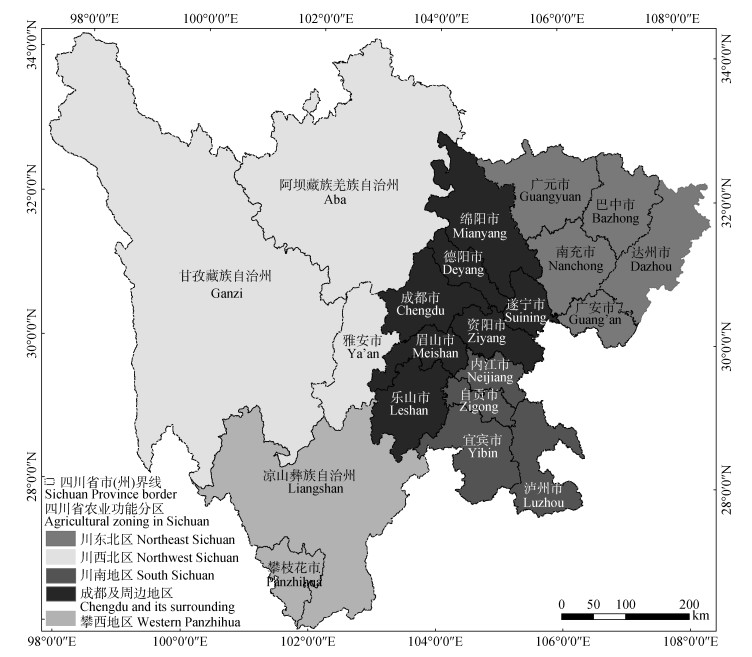
图1四川省农业功能分区
Figure1.Agricultural zoning in Sichuan Province
 下载: 全尺寸图片幻灯片
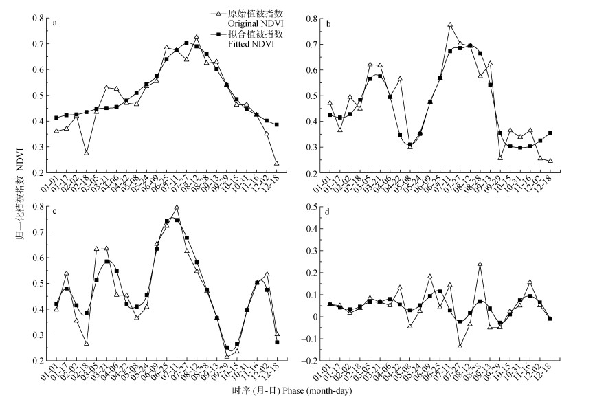
图2不同耕地熟制的NDVI时序曲线(a: 1熟制; b: 2熟制; c: 3熟制; d:撂荒地)
Figure2.Time series NDVI curves of farm land with different cropping systems (a: single cropping system; b: double cropping system; c: triple-cropping system; d: non-cultivated land)
下载: 全尺寸图片幻灯片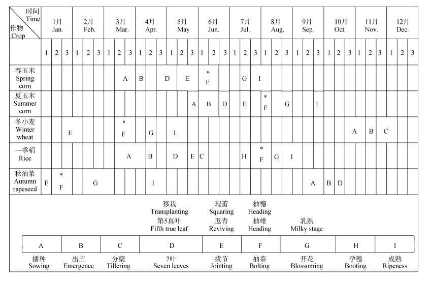
图3四川省主要作物物候节律
图中1、2、3分别表示各月的上、中、下旬; *表示该作物种的NDVI峰值物候期。
Figure3.Phenology stages of main crops in Sichuan Province
In the figure, 1, 2 and 3 respectively indicate the first, middle and last ten-day of each month; * indicate the phonological stages when the NDVI value reaches the theoretically maximum value.
下载: 全尺寸图片幻灯片
图42000—2016年四川省耕地熟制空间格局演变
Figure4.Spatio-temporal pattern of cropping index in Sichuan Province from 2000 to 2016
下载: 全尺寸图片幻灯片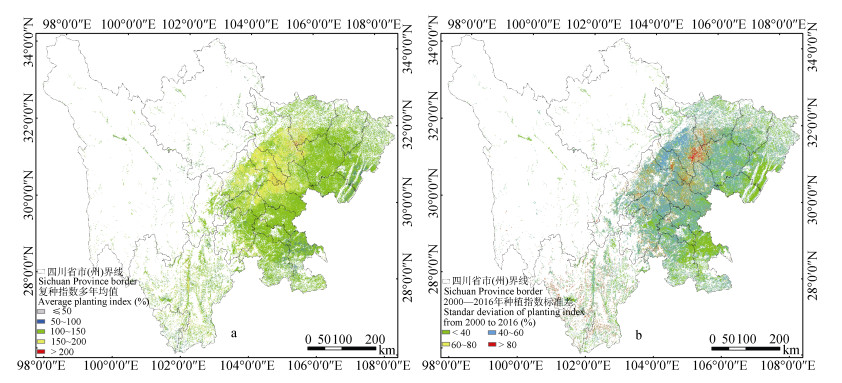
图5四川省2000—2016年耕地平均种植指数(a)及其标准偏差(b)的空间分布
Figure5.Spatial distribution patterns of average annual cropping index (MCI, a) and its standard deviation of MCI (b) in Sichuan Province from 2000 to 2016
下载: 全尺寸图片幻灯片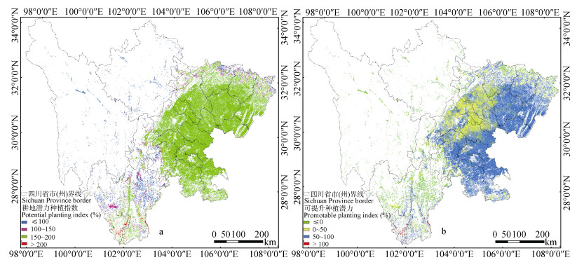
图6四川省耕地潜力种植指数(a)和可提升潜力种植指数(b)空间分布
Figure6.Spatial distribution pattern of potential cropping index (PMCI, a) and promotable PMCI (b) in Sichuan Province
下载: 全尺寸图片幻灯片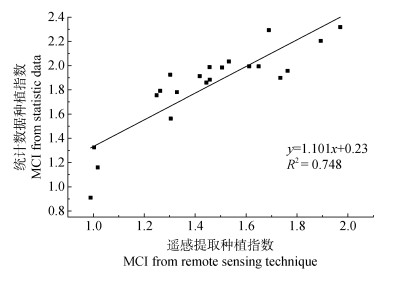
图7四川省耕地种植指数遥感提取结果与统计数据的相关分析(2000年)
Figure7.Correlation analysis of cropping index (MCI) from RS and that from statistical data of Sichuan Province (2000)
下载: 全尺寸图片幻灯片表1四川省各市(州)实际种植指数与潜力种植指数
Table1.Cropping index and potential cropping index of each city in Sichuan Province
| 市(州) City | 实际种植指数 Mean cropping index (%) | 潜力种植指数 Potential cropping index (%) | 市(州) City | 实际种植指数 Mean cropping index (%) | 潜力种植指数 Potential cropping index (%) | 市(州) City | 实际种植指数 Mean cropping index (%) | 潜力种植指数 Potential cropping index (%) | ||
| 甘孜州 Ganzi | 118.33 | 102.97 | 德阳市 Deyang | 165.12 | 199.34 | 内江市 Neijiang | 126.71 | 200.00 | ||
| 阿坝州 Aba | 112.88 | 102.95 | 成都市 Chengdu | 152.32 | 198.18 | 乐山市 Leshan | 130.20 | 186.77 | ||
| 绵阳市 Mianyang | 150.99 | 193.69 | 遂宁市 Suining | 144.41 | 200.00 | 自贡市 Zigong | 122.24 | 200.00 | ||
| 广元市 Guangyuan | 136.01 | 185.15 | 雅安市 Ya’an | 134.68 | 165.79 | 泸州市 Luzhou | 114.78 | 196.62 | ||
| 巴中市 Bazhong | 123.12 | 186.94 | 广安市 Guang’an | 117.95 | 199.98 | 凉山州 Liangshan | 130.90 | 144.05 | ||
| 达州市 Dazhou | 117.20 | 190.48 | 资阳市 Ziyang | 144.11 | 200.00 | 宜宾市 Yibin | 122.78 | 199.20 | ||
| 南充市 Nanchong | 128.98 | 200.00 | 眉山市 Meishan | 142.12 | 197.85 | 攀枝花市 Panzhihua | 128.91 | 200.90 |
下载: 导出CSV参考文献
| [1] | 卞新民, 冯金侠.多元多熟种植制度复种指数计算方法探讨[J].南京农业大学学报, 1999, 22(1):11-15 http://mall.cnki.net/magazine/Article/NJNY901.002.htm BIAN X M, FENG J X. Method of calculating cropping system index of diversified multiple cropping systems[J]. Journal of Nanjing Agricultural University, 1999, 22(1):11-15 http://mall.cnki.net/magazine/Article/NJNY901.002.htm |
| [2] | 闫慧敏, 曹明奎, 刘纪远, 等.基于多时相遥感信息的中国农业种植制度空间格局研究[J].农业工程学报, 2005, 21(4):85-90 http://www.cqvip.com/Main/Detail.aspx?id=15529786 YAN H M, CAO M K, LIU J Y, et al. Characterizing spatial patterns of multiple cropping system in China from multi-temporal remote sensing images[J]. Transactions of the CSAE, 2005, 21(4):85-90 http://www.cqvip.com/Main/Detail.aspx?id=15529786 |
| [3] | Pryor F L. The invention of the plow[J]. Comparative Studies in Society & History, 1985, 27(4):727-743 |
| [4] | 刘巽浩, 陈阜, 吴尧.多熟种植——中国农业的中流砥柱[J].作物杂志, 2015, (6):1-9 http://cdmd.cnki.com.cn/Article/CDMD-10537-2010061407.htm LIU X H, CHEN F, WU Y. Multiple cropping:The principal part of China's agriculture[J]. Crops, 2015, (6):1-9 http://cdmd.cnki.com.cn/Article/CDMD-10537-2010061407.htm |
| [5] | 何文斯, 吴文斌, 余强毅, 等. 1980-2010年中国耕地复种可提升潜力空间格局变化[J].中国农业资源与区划, 2016, 37(11):7-14 doi: 10.7621/cjarrp.1005-9121.20161102 HE W S, WU W B, YU Q Y, et al. Changes in spatio-temporal distribution of potential increment multiple cropping in China during 1980-2010[J]. Chinese Journal of Agricultural Resources and Regional Planning, 2016, 37(11):7-14 doi: 10.7621/cjarrp.1005-9121.20161102 |
| [6] | 左丽君, 张增祥, 董婷婷, 等.耕地复种指数研究的国内外进展[J].自然资源学报, 2009, 24(3):553-560 doi: 10.11849/zrzyxb.2009.03.021 ZOU L J, ZHANG Z X, DONG T T, et al. Progress in the research on the multiple cropping index[J]. Journal of Natural Resources, 2009, 24(3):553-560 doi: 10.11849/zrzyxb.2009.03.021 |
| [7] | 杨忍, 刘彦随, 陈玉福, 等.环渤海地区耕地复种指数时空变化遥感反演及影响因素探测[J].地理科学, 2013, 33(5):588-593 http://geoscien.neigae.ac.cn/CN/Y2013/V33/I5/588 YANG R, LIU Y S, CHEN Y F, et al. The remote sensing inversion for spatial and temporal changes of multiple cropping index and detection for influencing factors around Bohai rim in China[J]. Scientia Geographica Sinica, 2013, 33(5):588-593 http://geoscien.neigae.ac.cn/CN/Y2013/V33/I5/588 |
| [8] | 范锦龙, 吴炳方.基于GIS的复种指数潜力研究[J].遥感学报, 2004, 8(6):637-644 doi: 10.11834/jrs.20040614 FAN J L, WU B F. A study on cropping index potential based on GIS[J]. Journal of Remote Sensing, 2004, 8(6):637-644 doi: 10.11834/jrs.20040614 |
| [9] | 谢花林, 刘桂英. 1998-2012年中国耕地复种指数时空差异及动因[J].地理学报, 2015, 70(4):604-614 http://www.geog.com.cn/CN/article/downloadArticleFile.do?attachType=PDF&id=36403 XIE H L, LIU G Y. Spatiotemporal difference and determinants of multiple cropping index in China during 1998-2012[J]. Acta Geographica Sinica, 2015, 70(4):604-614 http://www.geog.com.cn/CN/article/downloadArticleFile.do?attachType=PDF&id=36403 |
| [10] | 谢花林, 邹金浪, 彭小琳.基于能值的鄱阳湖生态经济区耕地利用集约度时空差异分析[J].地理学报, 2012, 67(7):889-902 doi: 10.11821/xb201207003 XIE H L, ZOU J L, PENG X L. Spatial-temporal difference analysis of cultivated land use intensity based on emergy in Poyang Lake Eco-Economic Zone[J]. Acta Geographica Sinica, 2012, 67(7):889-902 doi: 10.11821/xb201207003 |
| [11] | 刘成武, 李秀彬.基于生产成本的中国农地利用集约度的变化特征[J].自然资源学报, 2006, 21(1):9-15 doi: 10.11849/zrzyxb.2006.01.002 LIU C W, LI X B. The changing characteristics of agricultural land use intensity in China based on the production cost[J]. Journal of Natural Resources, 2006, 21(1):9-15 doi: 10.11849/zrzyxb.2006.01.002 |
| [12] | 闫慧敏, 刘纪远, 曹明奎.近20年中国耕地复种指数的时空变化[J].地理学报, 2005, 60(4):559-566 doi: 10.11821/xb200504004 YAN H M, LIU J Y, CAO M K. Remotely sensed multiple cropping index variations in China during 1981-2000[J]. Acta Geographica Sinica, 2005, 60(4):559-566 doi: 10.11821/xb200504004 |
| [13] | 汪涌, 王滨, 马仓, 等.基于耕地面积订正的中国复种指数研究[J].中国土地科学, 2008, 22(12):46-52 doi: 10.3969/j.issn.1001-8158.2008.12.007 WANG Y, WANG B, MA C, et al. Study on the multiple cropping index based on revised cultivated land area in China[J]. China Land Science, 2008, 22(12):46-52 doi: 10.3969/j.issn.1001-8158.2008.12.007 |
| [14] | 石淑芹, 曹玉青, 吴文斌, 等.耕地集约化评价指标体系与评价方法研究进展[J].中国农业科学, 2017, 50(7):1210-1222 doi: 10.3864/j.issn.0578-1752.2017.07.004 SHI S Q, CAO Y Q, WU W B, et al. Progresses in research of evaluation index system and its method on arable land intensification:A review[J]. Scientia Agricultura Sinica, 2017, 50(7):1210-1222 doi: 10.3864/j.issn.0578-1752.2017.07.004 |
| [15] | 徐昔保, 杨桂山.太湖流域1995-2010年耕地复种指数时空变化遥感分析[J].农业工程学报, 2013, 29(3):148-155 http://www.cqvip.com/QK/90712X/201303/44964497.html XU X B, YANG G S. Spatial and temporal changes of multiple cropping index in 1995-2010 in Taihu Lake Basin, China[J]. Transactions of the CASE, 2013, 29(3):148-155 http://www.cqvip.com/QK/90712X/201303/44964497.html |
| [16] | 张霞, 焦全军, 张兵, 等.利用MODIS-EVI图像时间序列提取作物种植模式初探[J].农业工程学报, 2008, 24(5):161-165 http://www.cqvip.com/QK/90712X/200805/27466098.html ZHANG X, JIAO Q J, ZHANG B, et al. Preliminary study on cropping pattern mapping using MODIS-EVI image time series[J]. Transactions of the CSAE, 2008, 24(5):161-165 http://www.cqvip.com/QK/90712X/200805/27466098.html |
| [17] | 朱孝林, 李强, 沈妙根, 等.基于多时相NDVI数据的复种指数提取方法研究[J].自然资源学报, 2008, 23(3):534-544 doi: 10.11849/zrzyxb.2008.03.021 ZHU X L, LI Q, SHEN M G, et al. A methodology for multiple cropping index extraction based on NDVI time-series[J]. Journal of Natural Resources, 2008, 23(3):534-544 doi: 10.11849/zrzyxb.2008.03.021 |
| [18] | 彭代亮, 黄敬峰, 金辉民.基于MODIS-NDVI的浙江省耕地复种指数监测[J].中国农业科学, 2006, 39(7):1352-1357 http://www.cqvip.com/qk/90161X/200607/22414202.html PENG D L, HUANG J F, JIN H M. The monitoring for sequential cropping index of arable land in Zhejiang Province using MODIS-NDVI[J]. Scientia Agricultura Sinica, 2006, 39(7):1352-1357 http://www.cqvip.com/qk/90161X/200607/22414202.html |
| [19] | 张峰, 吴炳方, 刘成林, 等.利用时序植被指数监测作物物候的方法研究[J].农业工程学报, 2004, 20(1):155-159 http://www.cnki.com.cn/Article/CJFDTotal-DLGT201502007.htm ZHANG F, WU B F, LIU C L, et al. Methods of monitoring crop phonological stages using time series of vegetation indicator[J]. Transactions of the CSAE, 2004, 20(1):155-159 http://www.cnki.com.cn/Article/CJFDTotal-DLGT201502007.htm |
| [20] | 王文国, 何明雄, 潘科, 等.四川省水资源生态足迹与生态承载力的时空分析[J].自然资源学报, 2011, 26(9):1555-1565 doi: 10.11849/zrzyxb.2011.09.011 WANG W G, HE M X, PAN K, et al. Analysis of spatio-temporal characteristics of water resources ecological footprint and ecological carrying capacity in Sichuan Province[J]. Journal of Natural Resources, 2011, 26(9):1555-1565 doi: 10.11849/zrzyxb.2011.09.011 |
| [21] | 梁涛, 陈轩敬, 赵亚南, 等.四川盆地水稻产量对基础地力与施肥的响应[J].中国农业科学, 2015, 48(23):4759-4768 doi: 10.3864/j.issn.0578-1752.2015.23.017 LIANG T, CHEN X J, ZHAO Y N, et al. Response of rice yield to inherent soil productivity of paddies and fertilization in Sichuan Basin[J]. Scientia Agricultura Sinica, 2015, 48(23):4759-4768 doi: 10.3864/j.issn.0578-1752.2015.23.017 |
| [22] | 冯小琼, 陈军辉, 姜涛, 等.四川省2005-2014年农业源氨排放清单及分布特征[J].环境科学, 2017, 38(7):2728-2737 http://mall.cnki.net/magazine/Article/HJXX201401006.htm FENG X Q, CHEN J H, JIANG T, et al. Agricultural ammonia emission inventory and its spatial distribution in Sichuan Province from 2005 to 2014[J]. Environmental Science, 2017, 38(7):2728-2737 http://mall.cnki.net/magazine/Article/HJXX201401006.htm |
| [23] | 刘卫东, 石承苍, 任国业.四川省农业功能区划研究[J].中国农业资源与区划, 2008, 29(3):27-32 http://www.oalib.com/paper/5251846 LIU W D, SHI C C, REN G Y. Studies on regional planning of agriculture function of Sichuan Province[J]. Chinese Journal of Agricultural Resources and Regional Planning, 2008, 29(3):27-32 http://www.oalib.com/paper/5251846 |
| [24] | 林正雨, 何鹏, 李晓, 等.基于耕地压力指数的四川省粮食安全状况研究[J].中国农业资源与区划, 2015, 36(7):19-24 doi: 10.7621/cjarrp.1005-9121.20150703 LIN Z Y, HE P, LI X, et al. Food security of Sichuan Province based on cropland pressure index[J]. Chinese Journal of Agricultural Resources and Regional Planning, 2015, 36(7):19-24 doi: 10.7621/cjarrp.1005-9121.20150703 |
| [25] | 林正雨, 何鹏, 李晓, 等.四川省粮食安全状况研究[J].中国农学通报, 2015, 31(6):284-290 http://www.wanfangdata.com.cn/details/detail.do?_type=degree&id=Y1763408 LIN Z Y, HE P, LI X, et al. Study on food security in Sichuan Province[J]. Chinese Agricultural Science Bulletin, 2015, 31(6):284-290 http://www.wanfangdata.com.cn/details/detail.do?_type=degree&id=Y1763408 |
| [26] | 曾雨晴, 潘洪义, 周介铭.基于灰色马尔科夫模型的四川省耕地面积及耕地压力指数的分析与预测[J].江苏农业科学, 2016, 44(9):447-451 http://industry.wanfangdata.com.cn/dl/Detail/Periodical?id=Periodical_ghqzyyhj201508008 ZENG Y Q, PAN H Y, ZHOU J M. Analysis and prediction of cropland area and pressure index in Sichuan Province based on grey Markov model[J]. Jiangsu Agricultural Sciences, 2016, 44(9):447-451 http://industry.wanfangdata.com.cn/dl/Detail/Periodical?id=Periodical_ghqzyyhj201508008 |
| [27] | 江东, 王乃斌, 杨小唤, 等. NDVI曲线与农作物长势的时序互动规律[J].生态学报, 2002, 22(2):247-252 http://www.cnki.com.cn/Article/CJFDTOTAL-YGXB200406012.htm JIANG D, WANG N B, YANG X H, et al. Principles of the interaction between NDVI profile and the growing situation of crops[J]. Acta Ecologica Sinica, 2002, 22(2):247-252 http://www.cnki.com.cn/Article/CJFDTOTAL-YGXB200406012.htm |
| [28] | 张宏斌, 杨桂霞, 李刚, 等.基于MODIS-NDVI和NOAANDVI数据的空间尺度转换方法研究——以内蒙古草原区为例[J].草业科学, 2009, 26(10):39-45 http://www.wanfangdata.com.cn/details/detail.do?_type=perio&id=caoyekx200910005 ZHANG H B, YANG G X, LI G, et al. Study on the MODIS NDVI and NOAA NDVI based spatial scaling method-A case study in Inner Mongolia[J]. Pratacultural Science, 2009, 26(10):39-45 http://www.wanfangdata.com.cn/details/detail.do?_type=perio&id=caoyekx200910005 |
| [29] | 边金虎, 李爱农, 宋梦强, 等. MODIS植被指数时间序列Savitzky-Golay滤波算法重构[J].遥感学报, 2010, 14(4):725-741 http://www.oalib.com/paper/4367998 BIAN J H, LI A N, SONG M Q, et al. Reconstruction of NDVI time-series datasets of MODIS based on Savitzky-Golay filter[J]. Journal of Remote Sensing, 2010, 14(4):725-741 http://www.oalib.com/paper/4367998 |
| [30] | 唐鹏钦, 姚艳敏, 吴文斌, 等.基于遥感技术的耕地复种指数研究进展[J].中国农业资源与区划, 2010, 31(2):21-27 doi: 10.11821/dlxb201504008 TANG P Q, YAO Y M, WU W B, et al. Progress in multiple crop index based on remote-sensing technologies[J]. Chinese Journal of Agricultural Resources and Regional Planning, 2010, 31(2):21-27 doi: 10.11821/dlxb201504008 |
| [31] | 张晗, 任志远.多种时序NDVI重建方法比较与应用分析[J].中国农业科学, 2014, 47(15):2998-3008 doi: 10.3864/j.issn.0578-1752.2014.15.010 ZHANG H, REN Z Y. Comparison and application analysis of several NDVI time-series reconstruction methods[J]. Scientia Agricultura Sinica, 2014, 47(15):2998-3008 doi: 10.3864/j.issn.0578-1752.2014.15.010 |
| [32] | 殷悦, 陈倩, 时光训. NDVI时间序列数据的去噪重建方法对比[J].江苏科技信息, 2017, (7):39-47 http://www.cnki.com.cn/Article/CJFDTOTAL-YGJS201402026.htm YIN Y, CHEN Q, SHI G X. Comparison of techniques for reconstructing NDVI time series data sets[J]. Jiangsu Science & Technology Information, 2017, (7):39-47 http://www.cnki.com.cn/Article/CJFDTOTAL-YGJS201402026.htm |
| [33] | HIRD J N, MCDERMID G J. Noise reduction of NDVI time series:An empirical comparison of selected techniques[J]. Remote Sensing of Environment, 2009, 113(1):248-258 doi: 10.1016/j.rse.2008.09.003 |
| [34] | 曹云锋, 王正兴, 邓芳萍. 3种滤波算法对NDVI高质量数据保真性研究[J].遥感技术与应用, 2010, 25(1):118-125 doi: 10.11873/j.issn.1004-0323.2010.1.118 CAO Y F, WANG Z X, DENG F P. Fidelity performance of three filters for high quality NDVI time-series analysis[J]. Remote Sensing Technology and Application, 2010, 25(1):118-125 doi: 10.11873/j.issn.1004-0323.2010.1.118 |
| [35] | 吴文斌, 杨鹏, 唐华俊, 等.两种NDVI时间序列数据拟合方法比较[J].农业工程学报, 2009, 25(11):183-188 doi: 10.3969/j.issn.1002-6819.2009.11.033 WU W B, YANG P, TANG H J, et al. Comparison of two fitting methods of NDVI time series datasets[J]. Transactions of the CSAE, 2009, 25(11):183-188 doi: 10.3969/j.issn.1002-6819.2009.11.033 |
| [36] | RAMACHANDRAN B, JUSTICE C O, ABRAMS M J. Land Remote Sensing and Global Environmental Change[M]. New York:Springer, 2011 |
| [37] | 周增光, 唐娉.基于质量权重的Savitzky-Golay时间序列滤波方法[J].遥感技术与应用, 2013, 28(2):232-239 doi: 10.11873/j.issn.1004-0323.2013.2.232 ZHOU Z G, TANG P. VI-quality-based Savitzky-Golay method for filtering time series data[J]. Remote Sensing Technology and Application, 2013, 28(2):232-239 doi: 10.11873/j.issn.1004-0323.2013.2.232 |
| [38] | 申健, 常庆瑞, 李粉玲, 等. 2000-2013年关中地区耕地复种指数遥感动态监测[J].农业机械学报, 2016, 47(8):280-287 doi: 10.6041/j.issn.1000-1298.2016.08.037 SHEN J, CHANG Q R, LI F L, et al. Dynamic monitoring of cropping index in Guanzhong area using remote sensing in 2000-2013[J]. Transactions of the Chinese Society for Agricultural Machinery, 2016, 47(8):280-287 doi: 10.6041/j.issn.1000-1298.2016.08.037 |
| [39] | 梁守真, 马万栋, 施平, 等.基于MODIS NDVI数据的复种指数监测——以环渤海地区为例[J].中国生态农业学报, 2012, 20(12):1657-1663 http://www.ecoagri.ac.cn/zgstny/ch/reader/view_abstract.aspx?file_no=20121215&flag=1 LIANG S Z, MA W D, SHI P, et al. Monitoring multiple cropping index using MODIS NDVI data-A case study of Bohai Rim[J]. Chinese Journal of Eco-Agriculture, 2012, 20(12):1657-1663 http://www.ecoagri.ac.cn/zgstny/ch/reader/view_abstract.aspx?file_no=20121215&flag=1 |
| [40] | 高应波, 柳钦火, 李静, 等.基于时序植被指数特征时相识别的多熟制耕地提取新方法[J].遥感技术与应用, 2015, 30(3):431-438 http://www.geog.com.cn/CN/article/showVolumnArticle.do?nian=2011&juan=66 GAO Y B, LIU Q H, LI J, et al. A new methodology for extracting multiple cropping land based on distinguishing characteristic phases of time series vegetation index[J]. Remote Sensing Technology and Application, 2015, 30(3):431-438 http://www.geog.com.cn/CN/article/showVolumnArticle.do?nian=2011&juan=66 |
| [41] | 范锦龙, 吴炳方.复种指数遥感监测方法[J].遥感学报, 2004, 8(6):628-636 doi: 10.11834/jrs.20040613 FAN J L, WU B F. A methodology for retrieving cropping index from NDVI profile[J]. Journal of Remote Sensing, 2004, 8(6):628-636 doi: 10.11834/jrs.20040613 |
| [42] | 丁明军, 陈倩, 辛良杰, 等. 1999-2013年中国耕地复种指数的时空演变格局[J].地理学报, 2015, 70(7):1080-1090 http://www.cqvip.com/QK/90059X/201507/665433438.html DING M J, CHEN Q, XIN L J, et al. Spatial and temporal variations of multiple cropping index in China based on SPOT-NDVI during 1999-2013[J]. Acta Geographica Sinica, 2015, 70(7):1080-1090 http://www.cqvip.com/QK/90059X/201507/665433438.html |
