HTML
--> --> -->The moving-off TPVs are found to have some relevance to the lower tropospheric vortexes over the eastern and southeastern flanks of the TP in southwestern China (Chen et al., 2004; Cheng, 2016; Li et al., 2017). Such vortexes are commonly referred to as Southwest China Vortexes (SWCVs), with the strongest cyclonic center occurring mostly around 700 hPa or 850 hPa (Wang et al., 1993; Cheng et al., 2016). SWCVs are important mesoscale to synoptic-scale systems that occur during summer and not only bring about locally intense rainfall over southwestern China (Wang et al., 1993; Chen et al., 2004) but also lead to downstream heavy rainfall over even wider swaths of eastern China as they migrate large distances eastward (Zhao et al., 2007; Chen et al., 2015; Wang and Liu, 2017). For instance, the record-breaking rainstorm event over Henan Province in May 2013 was caused by the eastward movement of a SWCV, resulting in severe damage to crops and houses (Wang and Liu, 2017).
During the summer of 2016, a series of persistent heavy rainfall events occurred within and south of the middle and lower reaches of the Yangtze Basin (MLY, Shao et al., 2018; Zhang et al., 2021); one record-breaking heavy rainfall event took place from 30 June to 6 July. Specifically, the weekly accumulated rainfall amount for some stations in Hubei and Anhui provinces exceeded 500 mm, with a maximum amount even greater than 1000 mm in the downtown areas of Wuhan City. This long-lasting rainfall event led to devastating floods and severe casualties of more than 330 people, with economic losses of at least $22 billion (U.S. dollars), becoming the second largest weather-related natural disaster in Chinese history (Zhou et al., 2018). The most intense rainfall was observed around 2100 UTC 30 June, with the 24-hour (from 0600 UTC 30 June to 0600 UTC 1 July) accumulated rainfall amount being greater than 160 mm and occurring mostly over the Hubei–Anhui–Jiangxi provinces (29.5°–33°N, 113°–119°E) within the MLY (Fig. 1h). As such, this target domain is selected as a key region to represent the MLY in examining the dynamical mechanism of the strongest rainfall event during the sub-period from 30 June to 1 July 2016. Following Ma et al. (2020), this strongest rainfall event over the MLY key region for the sub-period from 0600 UTC 30 June to 0600 UTC 1 July was thus deemed as an extreme MLY rainfall event in the present study. Ma et al. (2020) linked the occurrence of this extreme rainfall event with the potential vorticity (PV) advection associated with an eastward migrating TPV. Through the quantitative diagnostics for the PV-related omega equation, they found that during the event the strong ascending motion was dynamically induced by the PV advection increasing with height, and the positive PV advection in the middle-upper troposphere was produced because the off-TP TPV was advected by westerlies toward the MLY region (cf. Figs. 1b–d). However, they did not examine the contributions of the TPV-related diabatic heating feedback and the low-level SWCV (Figs. 1f–h) located over the middle Yangtze River during this extreme event.
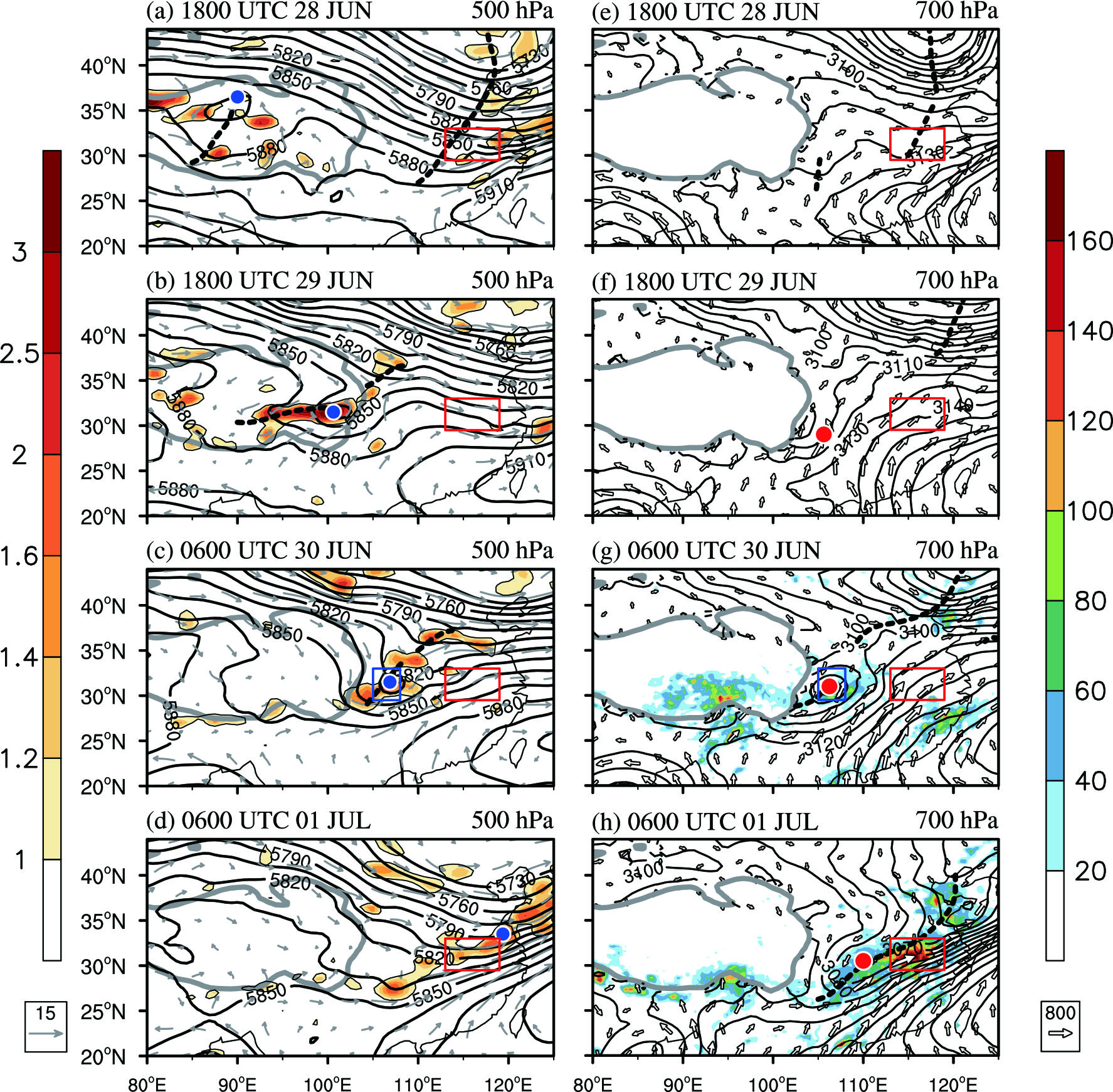 Figure1. Geopotential height (thick black contours; units: gpm), horizontal wind (gray vectors; units: m s?1), and PV (color shading with respect to left color bar; units: PVU, 1 PVU = 10?6 K m2 s?1 kg?1; the 1-PVU contours are highlighted by thin black curves) on the 500-hPa isobaric surface at (a) 1800 UTC 28 June, (b) 1800 UTC 29 June, (c) 0600 UTC 30 June, and (d) 0600 UTC 1 July 2016. Blue solid circles (dashed black curves) mark the center position of the TPV (the location of the trough-line) at 500 hPa. (e)–(h) Same as (a)–(d), but for the 700-hPa geopotential height (contours; units: gpm) and vertically integrated (1000–300 hPa) water vapor flux (hollow vectors; units: kg m?1 s?1). Red solid circles (dashed black curves) mark the center position of the SWCV (the location of the trough-line) at 700 hPa. The color shadings (with respect to right color bar) in (g) and (h) respectively show the 24-hour accumulated rainfall (units: mm) from 0600 UTC 29 June to 0600 UTC 30 June and from 0600 UTC 30 June to 0600 UTC 1 July 2016. The red rectangle in each panel denotes the key region (29.5°–33°N, 113°–119°E) representing the middle and lower reaches of the Yangtze Basin (MLY) where the extreme rainfall event occurred. The blue rectangles in (c) and (g) denote the eastern Sichuan Basin (ESB) region. The Tibetan Plateau with terrain altitude above 3000 m is outlined by thick gray curve.
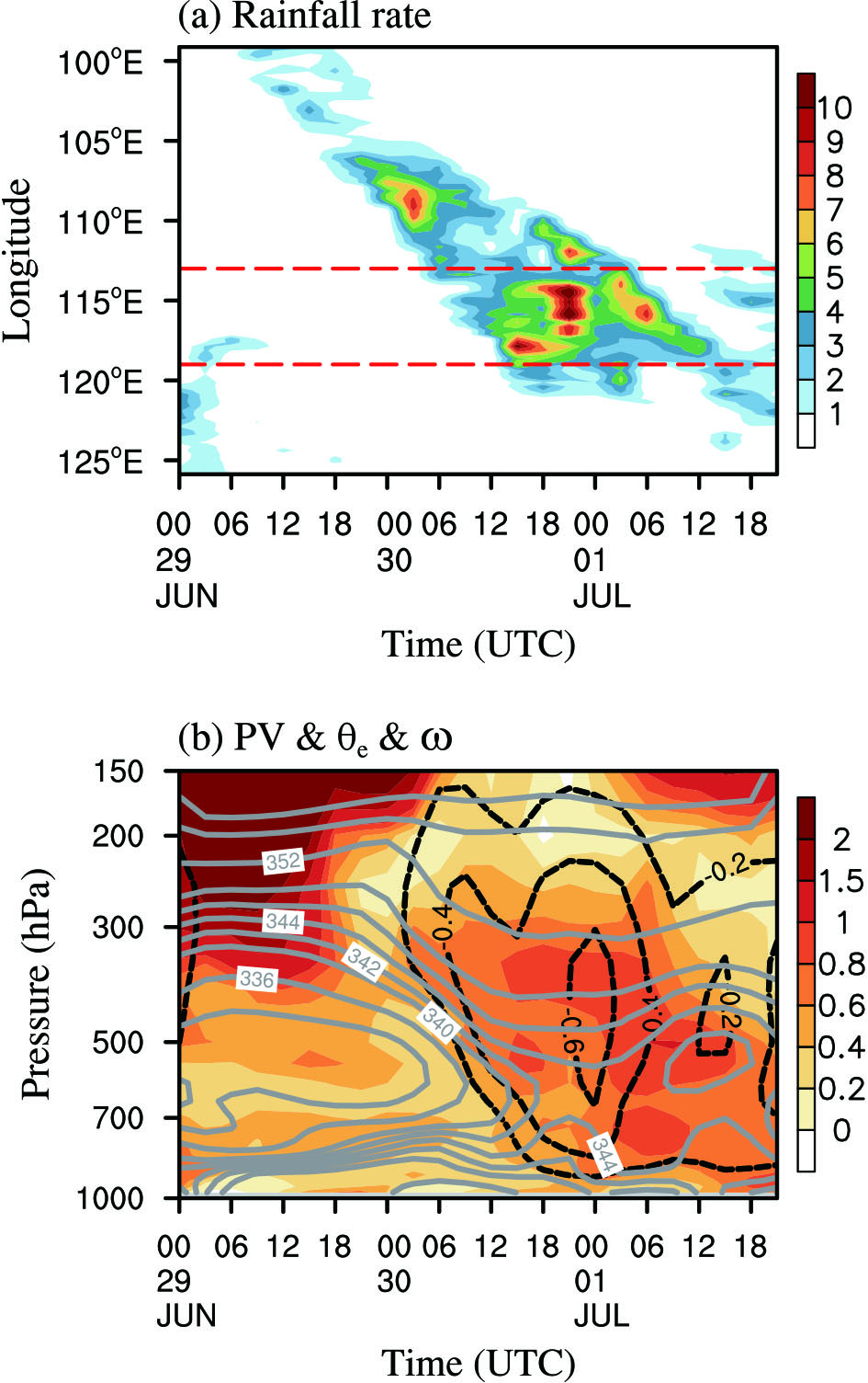 Figure2. (a) Longitude–time cross section of TRMM-derived rainfall rate averaged over the latitudinal band (29.5°–33°N) of the MLY key region (color shading, units: mm h?1) from 0000 UTC 29 June to 2100 UTC 01 July 2016. The dashed red lines show the western and eastern boundaries of the MLY key region. (b) Pressure–time cross section of area-averaged PV (color shading; units: PVU), equivalent potential temperature (θe, solid gray curves, units: K), and vertical velocity (
For the mesoscale to synoptic-scale system such as the TPV or SWCV, except for variations in relative vorticity, changes in vertical velocity are crucial to its development and movement (Hoskins et al., 1985). Hoskins et al. (2003) linked the omega variation with the PV forcing, reexamining how the vertical motion is generated even in the presence of diabatic heating under the quasigeostrophic or the semigeostrophic frameworks. The components of vertical velocity associated with the system development were found to satisfy an omega equation with forcing determined from the relative advection of interior PV and boundary temperature as well as diabatic heating effect.
Ma et al. (2020) only investigated the impact of the TPV-related PV advection on the MLY extreme rainfall event from 30 June to 1 July 2016 (or “MLY extreme rainfall event” in short), without examining the contribution of the SWCV and its combined effect with the TPV. Therefore, the objective of the present study is to explore the downstream influences on this MLY extreme rainfall event of the TPV in conjunction with the SWCV from a PV perspective. Based on the PV–omega equation, the different components of vertical motion arising from PV forcing are also examined to reveal the dynamical mechanism of how the upstream TPV migrated eastward to coalesce and re-separate with the SWCV, thereby explaining the cause for the MLY extreme rainfall event.
Section 2 introduces the data and methods used in this study. Section 3 describes the MLY extreme rainfall event in association with the TPV and SWCV. Section 4 analyzes the downstream impact of the two vortexes on the MLY extreme rainfall event from a PV perspective, and different ascending components of vertical velocity related to PV are examined in section 5. Finally, a summary and discussion are given in section 6.
2.1. Data
The 3-hourly gridded satellite-observed rainfall data with a spatial resolution of 0.25° longitude × 0.25° latitude are provided by the National Aeronautics and Space Administration’s Tropical Rainfall Measuring Mission (TRMM, Huffman et al., 2007). The atmospheric circulation data including air temperature, wind field, PV, geopotential height, and specific humidity are extracted from Version 2 of the Modern-Era Retrospective Analysis for Research and Applications (MERRA-2) products produced by the Global Modeling and Assimilation Office (Gelaro et al., 2017), which are available at 3-hour intervals. The MERRA-2 reanalysis data include 42 isobaric surfaces from 1000 hPa to 0.1 hPa, with a horizontal resolution of 0.625° longitude × 0.5° latitude.2
2.2. Methods
32.2.1. Identification for the TPV and SWCV
Generally, a TPV is defined as a local minimum in the geopotential height field at 500 hPa appearing over the TP, with one or more closed geopotential height contours or cyclonic winds in the vicinity of three neighboring weather stations (Lhasa Project Group on Qinghai-Xizang Plateau Meteorology, 1981). In combination with the method for defining the surface cyclone (Wernli and Schwierz, 2006), the present study defines the TPV center as a local minimum of the 500-hPa geopotential height within closed or semi-closed height contours, with the maximum relative vorticity in cyclonic flow during the TPV generated and migrated eastward over the TP and before it incorporated into the downstream 500-hPa trough of geopotential height fields. For convenience of describing and highlighting its subsequent effect on the MLY extreme rainfall event during and after the TPV merged into the 500-hPa height trough, we still tracked this vortex system and continued to call it as the TPV, except that the TPV center was determined as a local minimum within the trough corresponding to maximum relative vorticity. Similarly, the SWCV center is defined on the 700-hPa isobaric surface with local minimum geopotential height together with maximum relative vorticity.3
2.2.2. PV equation
The PV equation in the isobaric coordinate system can be expressed as follows (Ertel, 1942; Hoskins et al., 1985; Hoskins, 1991, 1997, 2015):where P is Ertel PV and is the dot product of the absolute vorticity vector for unit mass and the potential temperature gradient:


3
2.2.3. Vertical motion decomposition
Following Hoskins et al. (2003), Wu et al. (2020) divided the vertical velocity (


where
and
where


In the isobaric and isentropic coordinate systems,
It follows that
The weather system under current consideration is dominated by an isolated region of large PV, and the tilt of isentropic surfaces is small in both the longitudinal and latitudinal directions, as shown in Fig 3. Thus, the second term on the right-hand side of the above formula can be neglected, and we can reach the following approximation:
 Figure3. Pressure–longitude cross sections (30°–32°N) of PV (color shading and contours; units: PVU; the 1-PVU contours are highlighted by black solid curves), zonal-vertical circulation (vectors; zonal wind in m s?1 and vertical motion (multiplied by a factor of ?50) in Pa s?1, reference vector is given at bottom right), and magnitude of horizontal water vapor flux (purple contours; units: 10?3 kg m?1 Pa?1 s?1) superimposed on the potential temperature (dashed curves; units: K) during the coalescence stage of the TPV with the SWCV over the ESB region for (a) 1800 UTC 29 June, (b) 0000 UTC 30 June, (c) 0600 UTC 30 June, and during the re-separation stage of the TPV from the SWCV over the MLY key region for (d) 1200 UTC 30 June, (e) 1800 UTC 30 June, and (f) 0000 UTC 01 July 2016. The gray shading shows the terrain altitude associated with the Tibetan Plateau. The blue and red bold solid lines marked along the abscissa represent the zonal ranges of the ESB region and MLY key region, respectively.
Because in the limit of small Rossby number for large-scale atmospheric motion, the wind vector can be replaced by geostrophic wind, in this case, the omega equation for

Eq. (10) indicates that isentropic-displacement vertical velocity


3.1. Middle and lower tropospheric flow configurations
As introduced in section 1, the focus of this study is on the extreme rainfall event over the MLY key region (red rectangles in Fig. 1) for the period of 30 June to 1 July 2016. Thus, Fig. 1 shows the 500-hPa and 700-hPa circulation evolutions before and during this extreme event from 1800 UTC 28 June to 0600 UTC 1 July 2016 to illustrate the large-scale flow reconfiguration relating to the TPV and SWCV.Note in Fig. 1a that almost two days before the event, an extraordinarily strong western Pacific subtropical high (WPSH) was present in the middle troposphere on 1800 UTC 28 June, with an unprecedented intensity characterized by the 5910-gpm contour located west of the southeastern coast of China. To the north of the zonal ridge line of the WPSH around 25°N, there was a meridionally-elongated large-scale westerly trough in the midlatitudes around 115°E (Fig. 1a). Thus, the strong northwesterlies behind the trough intruded southward to reach south of 30°N over central China, while the southwesterlies prevailed in front of the trough over eastern China, with discrete high PV greater than 1 PVU (1 PVU = 1 × 10?6 K kg?1 m2 s?1). On the other hand, there was an almost closed cyclonic circulation over the western and central TP at 1800 UTC 28 June (Fig. 1a), signifying the existence of a TPV. Meanwhile, some areas with high PV greater than 1.2 PVU were observed to exist around the TPV or within the entire trough zone over the TP, indicating that the TPV had already formed. Data analysis indicates that this TPV had formed at 1800 UTC 27 June (Ma et al. 2020). Its formation mechanism will be given in a separate study.
Similar to 500 hPa, the westward-extended WPSH was also evident at 700 hPa (Fig. 1e), with strong southwesterlies on its northwestern side transporting moisture toward the south of the MLY key region, as evidenced by a poleward-directed corridor of strong vertically integrated water vapor flux (Simmonds et al., 1999). Note that the midlatitude trough elongating southward into the key region and its upstream ridge at 700 hPa (Fig. 1e) were located east of the corresponding trough and ridge at 500 hPa (Fig. 1a), clearly reflecting the baroclinic structure of Rossby waves in the middle and lower troposphere. Note also that in the lower troposphere a shallow trough existed over Sichuan Basin along 104°E between 25°N and 30°N (Fig. 1e), which facilitated the subsequent cyclogenesis of a SWCV (Fig. 1f).
With the TPV migrating continually eastward to reach the eastern edge of the TP by 1800 UTC 29 June (Fig. 1b), the TPV-related northeast–southwest oriented trough of the previous day (Fig. 1a) at 500 hPa was transformed into a narrow and zonally-elongated trough (cyclonic shear line), accompanied by extraordinarily high PV greater than 3 PVU locally (Fig. 1b), indicating that the TPV was intensified concomitantly. Meanwhile, another shallow off-TP trough was generated to the northeast of the TPV (Fig. 1b), forming a typical flow pattern of "Northern trough and Southern vortex", as suggested by previous studies such as Yu and Gao (2008). Consequently, the southwesterlies in front of these two troughs were evidently strengthened (Fig. 1b) due to an enhanced horizontal gradient of the geopotential height relative to the WPSH at 500 hPa. In turn, such warm and moist southwesterlies were conducive to the further intensification and subsequent movement of the TPV (Figs. 1b and 1c), as suggested by Li et al. (2011, 2014). In correspondence with the intensified TPV (Fig. 1b), a SWCV formed at 700 hPa in northeastern Yunnan province with the vortex center around 26°N and 104°E (Fig. 1f), because more moisture was transported to the north of 30°N along the periphery of the eastern TP, as evidenced by southwesterly water vapor flux (Fig. 1f).
Subsequently, the TPV moved completely away from the TP to reach the Sichuan Basin and was embedded in a northeast–southwest elongated 500-hPa trough at 0600 UTC 30 June (Fig. 1c). This moving-off TPV resulted in a wide range of locally moderate rainfall along its migrating path over the southern TP as well as the large downhill terrain area during the period from 0600 UTC 29 June to 0600 UTC 30 June (as shown in Fig. 1g). According to Zheng et al. (2013), the diabatic latent heating ahead of a vortex not only intensifies the local vertical vorticity but also affects the migrating direction of the vortex (as discussed further in section 4). In response to the moving-off TPV (Fig. 1c), the SWCV developed explosively with a local minimum of geopotential height less than 3070 gpm (Fig. 1g). The centers of these two vortexes were located within almost the same domain over the Eastern Sichuan Basin (ESB, 29.5°–33°N, 105°–108°E), indicating that the SWCV coalesced vertically with the TPV to form a deep cyclonic circulation system. Thus, this ESB domain (shown as blue rectangles in Figs. 1c and 1g) is defined as another key region to demonstrate the coalescence process of these two vortexes in the following sections. On the other hand, such a deepened SWCV also sped up the southwesterlies on its eastern side, which worked in conjunction with the eastward-propagating and southward-extending midlatitude trough to cause the water vapor flux to veer right, favoring the moisture transport towards the MLY (Fig. 1g). Noticeably, the TPV migrated drastically across the MLY key region to the coastal area from 0600 UTC 30 June to 0600 UTC 1 July (Fig. 1d), whereas the SWCV moved less, indicating that the TPV was re-separated from the SWCV. The almost stagnant SWCV was connected with the 700-hPa trough to the north in such a way that the low-level jet stream (LLJ) between the SWCV and WPSH became stronger (Fig. 1h), resulting in enhanced moisture convergence over the MLY key region and extremely intense rainfall during this 24-hour period (Fig. 1h). Note also that the TPV was mainly incorporated with the southern segment of the 500-hPa trough over eastern China during the heavy rainfall episode (Figs. 1c and 1d), thus the midlatitude Rossby wave acted as a carrier to propagate the TPV. In fact, the extreme rainfall event resulted mostly from the downstream impacts of the TPV together with the SWCV (as discussed below).
2
3.2. Dynamical and thermodynamical conditions before and during the extreme rainfall event
For the MLY key region, as shown in Figs. 1g and 1h, the extreme rainfall happened mostly during the period when the TPV re-separated from the SWCV. Figure 2a illustrates the longitude-time cross section (averaged along the key-region latitudes) of 3-hourly rainfall rate. The rainfall belt originated from at least 106°E and then propagated eastward into the MLY key region, corresponding to the eastward-moving TPV. Note from Fig. 2a that the heavy rainfall over the MLY key region started after 0600 UTC 30 June when the two vortexes were merged vertically around 106°E, suggesting an important role of the SWCV coalescing with the overlying TPV in generating the MLY extreme rainfall event (as discussed below).Since the rainfall occurrence depends on ascending motion of warm and moist air, the pressure-time cross section of the area-averaged equivalent potential temperature and vertical velocity over the MLY key region is investigated and shown in Fig. 2b. Note that before 0600 UTC 30 June, very warm and moist air was present in the lower troposphere, as evidenced by large-value equivalent potential temperature (θe > 334 K below 700 hPa). Importantly, the equivalent potential temperature decreased with increasing height in the lower troposphere (below 700 hPa), indicating that the low-level atmosphere was thermodynamically unstable to vertical motion and that regional convection could be likely to develop.
As expressed dynamically in Eq. (10), the isentropic-displacement vertical motion (


4.1. PV evolution associated with the TPV and SWCV
The above analyses indicate that the coalescence and re-separation of the TPV–SWCV system have an important impact on the variations in downstream circulation. To clarify the vertical interactions of the TPV with the SWCV and their influences on the extreme rainfall event, Fig. 3 illustrates pressure–longitude cross sections of PV fields as well as the zonal–vertical circulation averaged along the conjunct track (30°–32°N) of the two vortexes during the period from 1800 UTC 29 June to 0000 UTC 1 July. Note in Fig. 3a that the TPV exhibited a slightly eastward-tilted high-PV column over the eastern edge of the TP between 98°E and 103°E from the surface to 300 hPa, corresponding to the arrival of the TPV on 1800 UTC 29 June (Fig. 1b), with a maximum PV center greater than 2 PVU indeed located at 500 hPa. Moist air was transported upward by strong ascending motion, with large horizontal water vapor fluxes greater than 5 × 10?3 kg m?1 Pa?1 s?1 occurring above 400 hPa within and ahead of the TPV center. As shown in Fig. 1b, such large water vapor fluxes around the eastern TP resulted mostly from the 500-hPa southwesterlies. Note that another center of larger water vapor fluxes existed over the MLY key region, especially below 700 hPa (Fig. 3b), which was caused by low-level southwesterlies on the northwestern side of the WPSH (Fig. 1f).Six hours later, the high-PV column of the TPV was far from the high-altitude platform of the eastern TP (Fig. 3b), and the intensity of the TPV was evidently enhanced. Below and ahead of the TPV-related high-PV column, a weak PV zone associated with the SWCV was present around 105°E (Fig. 3b), accompanied by large water vapor fluxes greater than 1 × 10?2 kg m?1 Pa?1 s?1. As such, the SWCV-generated ascent in the middle and lower troposphere happened to superimpose with the TPV-related updrafts in the middle and upper troposphere, further enhancing the ascending motion in the entire troposphere (Fig. 3b), resulting in locally heavy rainfall over the ESB region (Fig. 2a). Obviously, such considerable ascending motion consisted of different components (


Note in Fig. 3b that the high-PV column of the TPV tended to be advected eastward by the horizontal westerlies, and the westerlies were stronger in the middle-upper troposphere than in the lower troposphere, causing the TPV to completely merge with the underlying SWCV to form a deep high-PV system over the downstream region at 0600 UTC 30 June (Fig. 3c). The SWCV, which was manifested by high PV in lower troposphere, was intensified significantly by 0600 UTC (Fig. 3c) compared with 0000 UTC (Fig. 3b), indicating the great effect of the TPV on the development of the underlying SWCV. The merged TPV–SWCV then caused the flow amplification in the midtroposphere over eastern China around 0600 UTC 30 June (as shown in Fig. 1c), triggering significant downstream development of ascending motion (Fig. 3c). As a result, extreme rainfall began over the MLY key region (Fig. 2a). Note in Fig. 3c that the isentropic surfaces, especially in the upper troposphere, formed as a concave distribution around the merged system. As suggested by Hoskins et al. (1985), an isolated tropospheric high-PV forcing could induce warm temperature anomalies above the PV forcing center and cold anomalies below the center due to the thermal wind relationship (see their Fig. 8). Therefore, in addition to the airmass rising along the sloping surfaces in the meridional direction (as discussed later in section 5), the contractive isentropic surfaces around the merged PV system guide the airmass to climb in strong westerlies, inducing distinct ascending


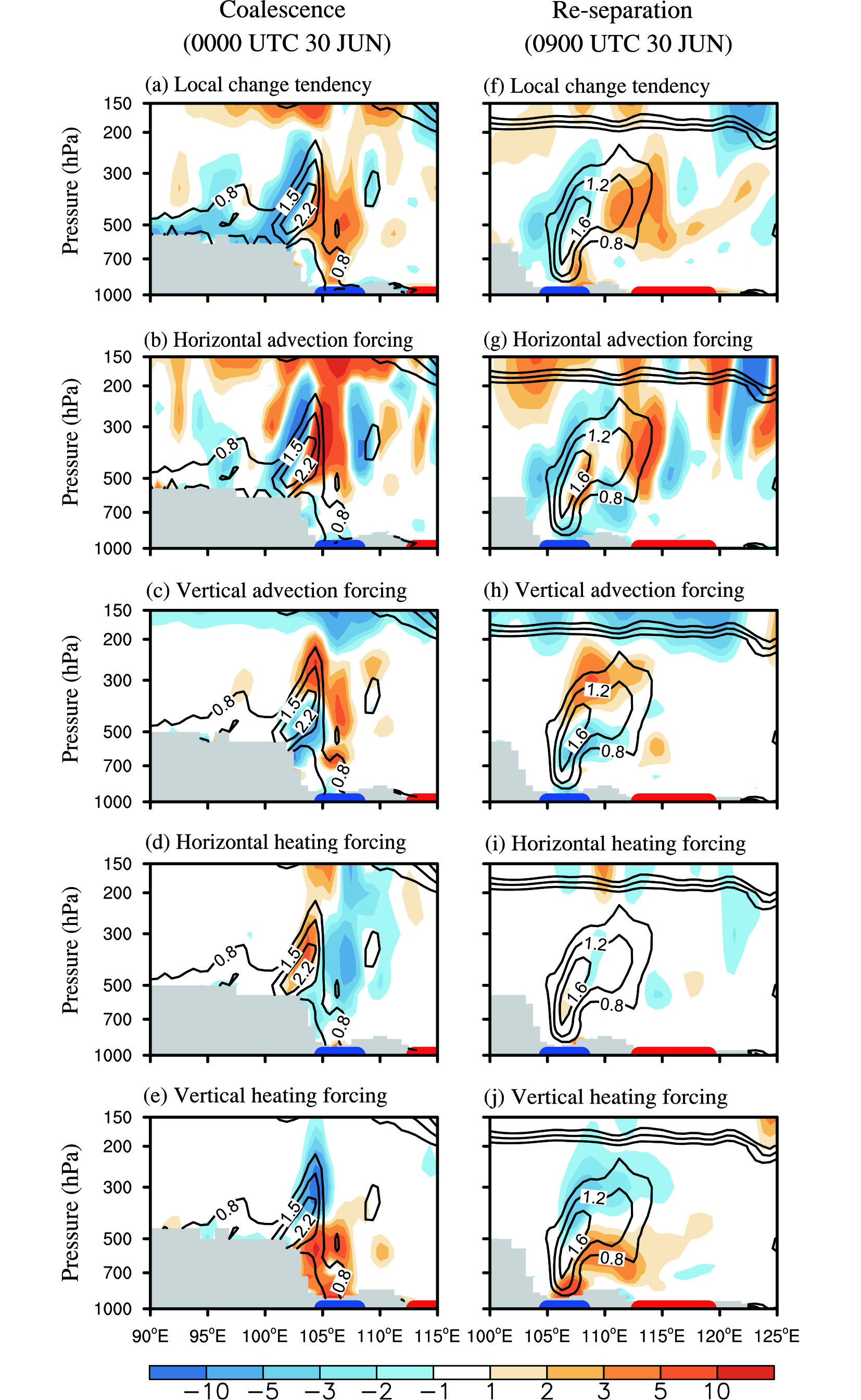 Figure4. Pressure–longitude cross sections (30°–32°N) of (a) local PV tendency (color shading; units: 10?5 PVU s?1) and its forcing terms (color shading; units: 10?5 PVU s?1) in Eq. (1) due to (b) horizontal PV advection, (c) vertical PV advection, (d) horizontal diabatic heating, and (e) vertical diabatic heating for the coalescence stage of the moving-off TPV with the SWCV around 0000 UTC 30 June 2016. Black contours show the actual PV distribution at 0000 UTC 30 June (indicated by several contours of 0.8, 1.5, and 2.2 PVU) in each panel. (f)–(j) Same as (a)–(e), but for the re-separation stage of the TPV–SWCV at 0900 UTC 30 June 2016. The gray shading shows the terrain altitude associated with the Tibetan Plateau. The blue and red bold solid lines marked along the abscissa represent the zonal ranges of the ESB region and MLY key region, respectively.
2
4.2. Quantitative PV diagnosis
To substantiate the relative importance of the PV advection-related dynamical factors in causing the TPV to coalesce with and re-separate from the SWCV through PV redistribution, a quantitative PV budget was performed based on Eq. (1) to calculate the net PV tendency and its components created by horizontal and vertical PV advection as well as nonuniform diabatic heating at 0000 UTC 30 June and 0900 UTC 30 June.As shown in Fig. 4a, net positive PV tendency occurred ahead of the high-PV column (indicated by solid lines) of the TPV before the coalescence of the two vortexes, with net negative PV tendency in the rear, signifying that the high-PV column would develop eastward, with the low-level vortex intensifying concurrently over the ESB region. For the forcing terms contributing to the net PV tendency, there was strong positive horizontal PV advection ahead of the high-PV column of the TPV above 500 hPa extending to 150 hPa over the ESB region (Fig. 4b), accompanied by strong negative PV advection to its west and east. The PV tendency component created by the vertical gradient of diabatic heating had positive values in the lower troposphere over the ESB region (Fig. 4e), indicating the essential role of diabatic heating in the creation of high PV. Obviously, such newly generated high PV will be advected upward by vertical PV advection under strong ascending motion (Fig. 3b), with positive anomalies above the centers of both the TPV and SWCV and negative anomalies below (Fig. 4c). However, the PV tendency component created by the horizontal gradient of diabatic heating was negative (positive) ahead of (within) the high-PV column (Fig. 4d), which partly offset the positive horizontal PV advection (Fig. 4b). This made it clear that the TPV–SWCV coalescence resulted mostly from positive horizontal and vertical PV advection ahead of the high-PV column as well as the low-level PV generation by the nonuniform vertical diabatic heating, which also explain the rapid eastward movement of the TPV after 0000 UTC 30 June as shown in Fig. 3c.
The PV budget diagnoses (Figs. 4f–j) for the TPV–SWCV re-separation stage around 0900 UTC 30 June show that the net positive tendency in the middle-upper troposphere (Fig. 4f) over the western MLY key region (around 115°E) similarly resulted from the middle-upper tropospheric positive horizontal PV advection (Fig. 7g), while negative PV advection dominated in lower troposphere due to intense southerlies ahead of the SWCV transporting negative PV anomalies northward (this type of southerlies can be seen in Fig. 1g). This occurs because of atmospheric PV being spatially distributed with high values in the north and low values in the south (not shown). However, the net positive PV tendency in the lower troposphere (Fig. 4f) responsible for the intensification of the local SWCV was ascribed to the PV generation by nonuniform vertical diabatic heating (Fig. 4j). Note that the diabatic heating-generated PV component within 400–700 hPa (Fig. 4j) was completely offset by negative vertical PV advection (Fig. 4h). Thus, the TPV was then re-separated from the low-level SWCV due to the dominating horizontal PV advection (Fig. 3d). In fact, moderate rainfall over the MLY key region happened to begin after 0600 UTC 30 June, with the most intense rainfall concentrating from 0900 UTC 30 June to 1200 UTC 1 July (Fig. 2a). These facts reinforce the importance of the coalescence of the TPV with SWCV and their subsequent re-separation for the extreme rainfall event.


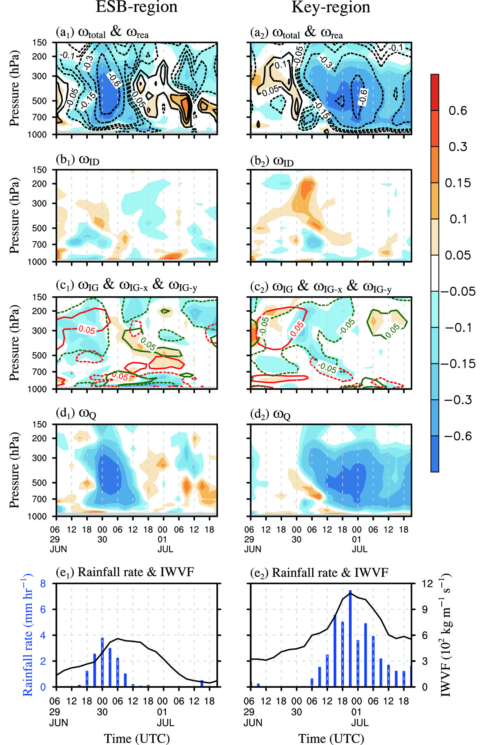 Figure5. Pressure–time cross sections of area-averaged (a1–a2) MERRA-2 data-provided vertical velocity (


As discussed in the previous sections, the interaction of the TPV and SWCV exerts great effect on the downstream circulation. Such a downstream effect of the merged TPV–SWCV system can be understood according to the spatiotemporal evolutions of the vertical velocity components. Note in Figs. 5b1–5b2 and 5c1–5c2 that ascending


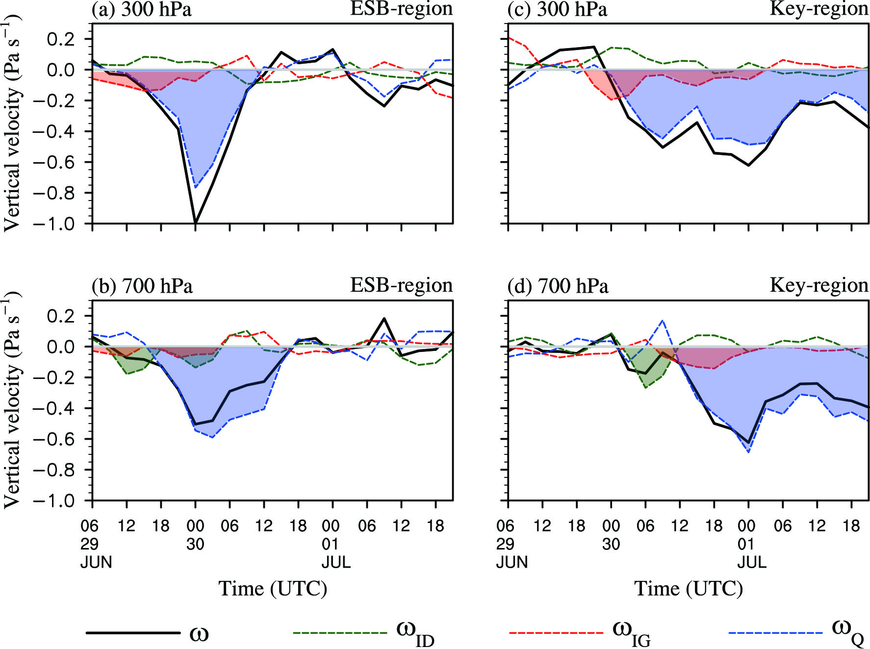 Figure6. Evolutions of area-averaged vertical velocity (ω; black curve; units: Pa s?1) and its components


 Figure7. Same as Fig. 6, but for the area-averaged
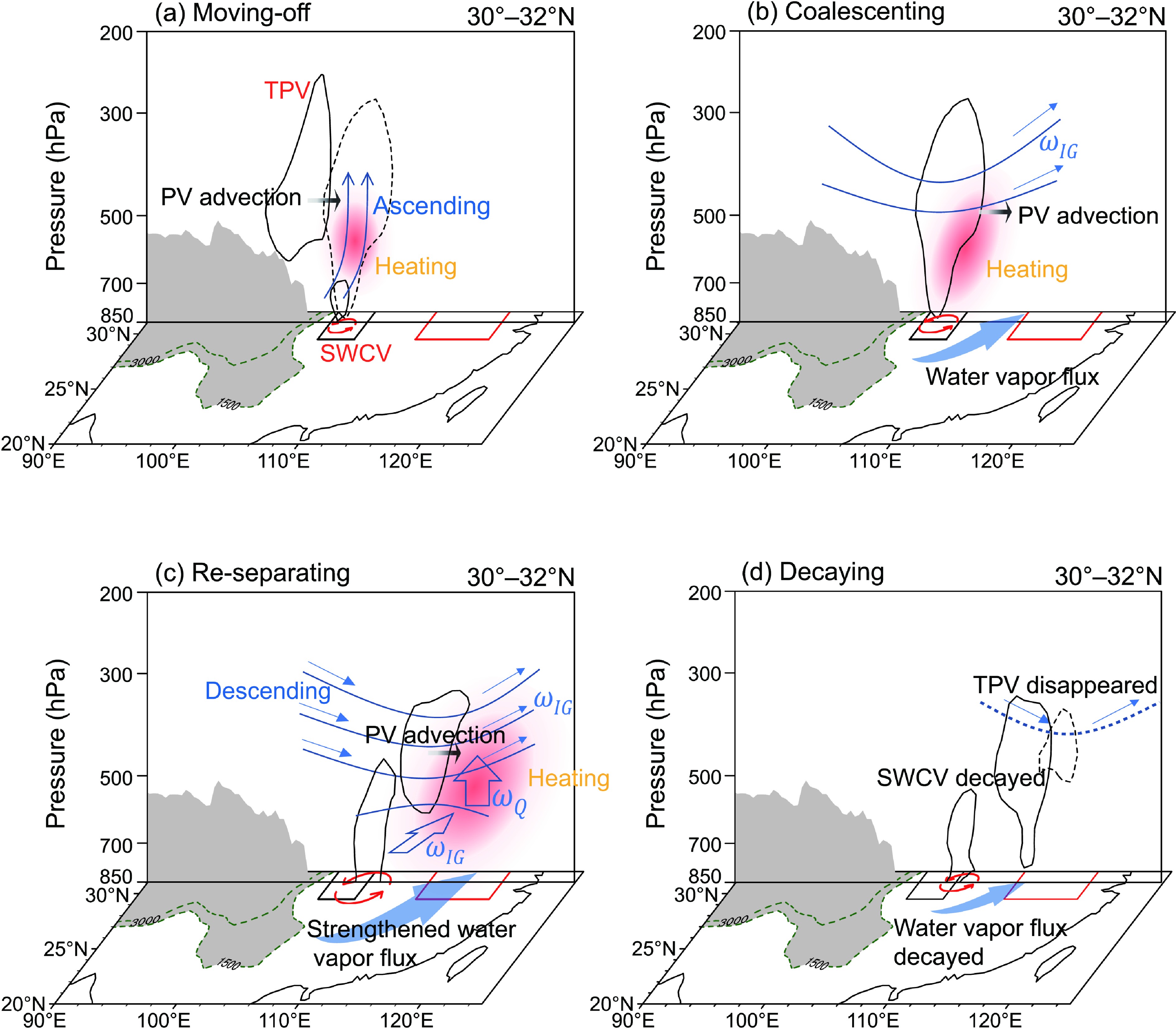 Figure8. Schematic diagram showing the 2016 MLY extreme rainfall event stages with the TPV and/or SWCV (cyclonic arrows) behavior and concomitant variations in PV (arbitrary polygons indicated by black solid or dashed curves represent the high PV equal to 1 PVU), vertical motion (upward arrows denote ascending motion and downward arrows signify descending motion) along the isentropic surfaces (concave-downward and convex-upward solid blue curves), and diabatic heating (red shading). The dashed curves denote the distribution of PV (dashed black lines) and isentropes (dashed blue lines) in the next moment. Red (black) parallelograms denote the MLY key region (ESB region). Vertical cross sections are averaged between 30°–32°N across the central key region. The gray shading shows the range and height of the Tibetan Plateau with terrain altitude greater than 1500 m. (a) Stage for the TPV moving off the TP in conjunction with the development of the SWCV. (b) Stage for the TPV coalescing with the SWCV over the ESB region to trigger upper-tropospheric ascending motion and to enhance lower-tropospheric convergent water vapor flux over the downstream MLY key region. (c) Stage for the MLY extreme rainfall peak, during which the TPV was re-separated from the SWCV to generate the strengthened water vapor flux and stronger ascending motion in terms of the lower-tropospheric isentropic-gliding vertical velocity (

More importantly, because the middle tropospheric air temperature was increasing due to rainfall-released condensation latent heating, the isentropic surfaces became more concave over the ESB region, leading to more sloping isentropic surfaces prevailing over the downstream key region, as illustrated in Fig. 3b. However, prior to the coalescence of the TPV and SWCV, the northwesterlies dominated the middle and upper troposphere over the key region (cf. Fig. 1b). Due to the sloping meridional distribution of isentropic surfaces (not shown), the meridional component of such northwesterlies could have induced descending


As discussed above, the ascending


However, the extreme ascending


Before the extreme rainfall event, the TPV was initially formed within a 500-hPa geopotential height trough over the northwestern TP around 1800 UTC 27 June and then migrated eastward, which resulted in the large amplification of the downstream meridional disturbance. When the moving TPV arrived at the eastern slope of the TP, it manifested as a slightly eastward-tilted high-PV column. Considerable ascending motion was induced ahead by a positive vertical gradient of horizontal PV advection created by the TPV-related high PV, giving rise to moderate rainfall locally and resultant diabatic latent heating, which also facilitated the development of the SWCV over the ESB region (Fig. 8a). Because the SWCV-related nonuniform vertical diabatic heating was also conducive to PV generation in the lower troposphere (as diagnosed by the PV budget), the SWCV-related low-level PV generation together with the TPV-related midtropospheric PV advection favored these two vortexes to coalesce vertically around 0600 UTC 30 June (Fig. 8b). The merged TPV–SWCV acted as a high-PV forcing feature and caused the middle-upper tropospheric isentropic surfaces to become concave downward over the ESB region. This enabled the airmass to glide along the upward-sloping isentropic surfaces over the MLY key region, generating the strong isentropic-gliding ascending motion (

Because the PV generation caused by the nonuniform diabatic heating in middle-upper troposphere was mostly offset by negative vertical PV advection, the net positive tendency in the middle-upper troposphere over the western MLY key region largely resulted from the positive horizontal PV advection, while negative PV advection was dominant in the lower troposphere due to intense southerlies in front of the SWCV transporting negative PV anomalies northward. Consequently, the TPV was re-separated from the low-level SWCV (Fig. 8c). The two re-separated high-PV systems favored even stronger isentropic gliding (


It should be noted that the present study only analyzes how the internal PV forcing and diabatic heating affect the development and variation of atmospheric vertical ascent and the associated precipitation. The validity of the omega equation analysis in the paper depends on the conditions for the quasigeostrophic equations: small Rossby number and small static stability differences from a basic stratification that is a function of p only. Because these conditions are not strictly satisfied in the TPV case study, the results of the analysis should be viewed as a qualitative indication of the processes involved. Besides, how the boundary forcing influences the development and variation has not been touched upon and deserves further investigation. In addition to the extreme rainfall stage of 1200 UTC 30 June–1200 UTC 12 July that was mainly examined in the present study, the subperiod of 4–5 July experienced the second most intense rainfall within the long-lasting rainfall period from 30 June to 6 July over the MLY key region. Given that this long-lasting period of rainfall was actually a wet episode of a quasi-biweekly oscillation of the Yangtze rainfall in summer 2016 (Zhang et al., 2021), we will explore how and to what extent the quasi-biweekly disturbances affect the above synoptic-scale extreme rainfall events based on multiscale interactions in the future.
Acknowledgements. The TRMM-based rainfall data are available at
