HTML
--> --> -->As a synoptic disturbance, Pakistan rainfall is greatly affected by large-scale circulations in both the lower and upper troposphere. Syed et al. (2010) found that an upper-tropospheric anticyclonic anomaly appears to the northwest of Pakistan a few days before the active phase of rainfall, and is centered at the northernmost region of Pakistan on the onset day of the active phase. In addition, Latif and Syed (2016) indicated that the upper-tropospheric anticyclonic anomaly over West Asia shows its strongest intensity two days before the monsoon onset (their Fig. 4), while the lower-tropospheric cyclonic anomaly to the south of Pakistan reaches its peak on the onset day (their Fig. 5). This lag of the lower-tropospheric anomaly to the upper-tropospheric anomaly suggests that the former may be affected by the latter. That is, the upper-tropospheric anticyclonic anomaly over West Asia, which is associated with upstream circulation anomalies such as the summer North Atlantic Oscillation (SNAO), may induce the lower-tropospheric cyclonic anomaly, which is further favorable to enhanced rainfall in Pakistan.
 Figure4. (a) Standardized time series of JJA mean precipitation anomalies in Pakistan (PKprec), the ACI, and the EASTI. (b?d) Scatterplots of the (b) PKprec and ACI, (c) PKprec and EASTI, and (d) ACI and EASTI. Red symbols in (b?d) indicate the values in 2010.
 Figure5. Horizontal wind anomalies (vectors; units: m s?1) at (a) 200 hPa and (b) 700 hPa regressed onto the standardized Pakistan JJA rainfall index (PKprec). Shading in (a) indicates zonal or meridional wind anomalies significant at the 0.05 level based on the Student’s t-test, and in (b) indicates the moisture flux divergence integrated from 925 to 600 hPa (units: 10?6 kg m?2 s?1) regressed onto the standardized PKprec. The blue and red shading indicates anomalous convergence and divergence of the moisture flux, respectively, and dots represent regions significant at the 0.05 level based on the Student’s t-test. Zonal or meridional wind anomalies significant at the 0.05 level are emboldened in (b). Red boxes indicate the domain used to define the ACI in (a) and EASTI in (b). The solid line in (b) delineates the topography higher than 3000 m.
Summer rainfall in Pakistan shows strong interannual variability, particularly relative to seasonal rainfall amounts (Naheed and Rasul, 2011). The coefficient variation, i.e., the ratio of the interannual standard deviation to the climatological average of seasonal rainfall amounts, is as high as 26% for summer rainfall in Pakistan (Hussain and Lee, 2016). Therefore, it is of great importance to better understand the mechanisms responsible for the interannual variability of summer rainfall in Pakistan.
It has been well documented that, on the interannual time scale, the upper-tropospheric anticyclonic/cyclonic anomalies over West Asia are closely related to more/less precipitation in Pakistan or India (Kripalani et al., 1997; Wu, 2002, 2017; Krishnan et al., 2009; Hong and Lu, 2016; Latif et al., 2017; Yadav, 2017). The upper-tropospheric anticyclonic/cyclonic anomalies are closely associated with the circumglobal teleconnection (CGT; Ding and Wang, 2005) or Silk Road Pattern (SRP; Lu et al., 2002; Enomoto et al., 2003), which are the two teleconnection patterns similar to each other at least over the Eurasian continent (Zhou et al., 2019). Previous studies have indicated that the CGT and SNAO affect summer rainfall in North Pakistan and Northwest India (Ding and Wang, 2005; Syed et al., 2012). Syed et al. (2012) showed that the positive phases of the CGT and SNAO, characterized by upper-tropospheric anticyclonic anomalies over the Northeast Atlantic and West Asia, respectively, are related to enhanced rainfall over Pakistan during the core summer season (July?August). Kazmi et al. (2016) utilized April?June upper-tropospheric zonal wind at 200 hPa over the northeastern Atlantic as a predictor for the interannual variation of July?August Pakistan rainfall, and explained this relationship through the appearance of the CGT in July?August.
The lower-tropospheric circulation anomalies associated with the interannual variation of Pakistan summer rainfall have been relatively less well investigated, as compared to their upper-tropospheric counterparts. Ullah and Gao (2012) suggested that the route of water vapor transport from the Arabian Sea to South Asia, which is associated with the monsoon trough, is crucial for the wet and dry conditions in Pakistan during summer. They arrived at this conclusion by analyzing two contrasting summers: 1994, an above-normal rainfall year in Pakistan, and 2002, a below-normal rainfall year. It has been well documented that the monsoon trough, which appears in the lower troposphere, is an important component of the South Asian summer monsoon, favoring active monsoon rainfall (e.g., Krishnamurti and Bhalme, 1976; Bollasina and Nigam, 2011). Therefore, it is reasonable to hypothesize that the lower-tropospheric circulation anomalies may play a crucial role in affecting the interannual variation of Pakistan summer rainfall.
In this study, we hypothesize that the interannual variability of Pakistan summer rainfall is a result of the tropical?extratropical interaction, which is characterized by the interaction between the tropical monsoon troughs and extratropical disturbances. Actually, some previous studies have demonstrated that such tropical?extratropical interaction plays a crucial role in triggering extreme rainfall weather events in Pakistan or South Asia (e.g., Hong et al., 2011; Vellore et al., 2016). On the other hand, this interaction may also be manifested as that between the upper and lower troposphere, i.e., the interaction between the anticyclonic anomaly to the northwest of Pakistan in the upper troposphere and the stronger monsoon trough in the lower troposphere. Therefore, the aim of this study is to investigate the interactions of the circulations associated with Pakistan rainfall variability, both meridionally and vertically.
The rest of this paper is organized as follows. The data and methods are described in section 2. The circulation anomalies associated with monthly Pakistan rainfall from June to September are shown in section 3, which indicates that these monthly circulation anomalies are similar in June, July and August. Therefore, in section 4, focusing on the June-July-August (JJA) averages, we show the upper- and lower-tropospheric circulation anomalies and compare these anomalies. Section 5 presents the main conclusions of this study and discusses some associated issues.
The monthly circulation reanalysis data are from the National Centers for Environmental Prediction?National Center for Atmospheric Research (Kalnay et al. 1996), with a horizontal resolution of 2.5° × 2.5°. In addition, the monthly precipitation data from the Climatic Research Unit (CRU), which are based on weather station records (version 4.04) (Harris et al. 2014), at a 0.5° × 0.5° horizontal resolution, were also applied. The time span of all the datasets is 1981?2017, consistent with that of the Pakistan station precipitation data. The anomalies stated in this study, for both precipitation and circulation, indicate the deviations relative to the climatological mean during 1981?2017.
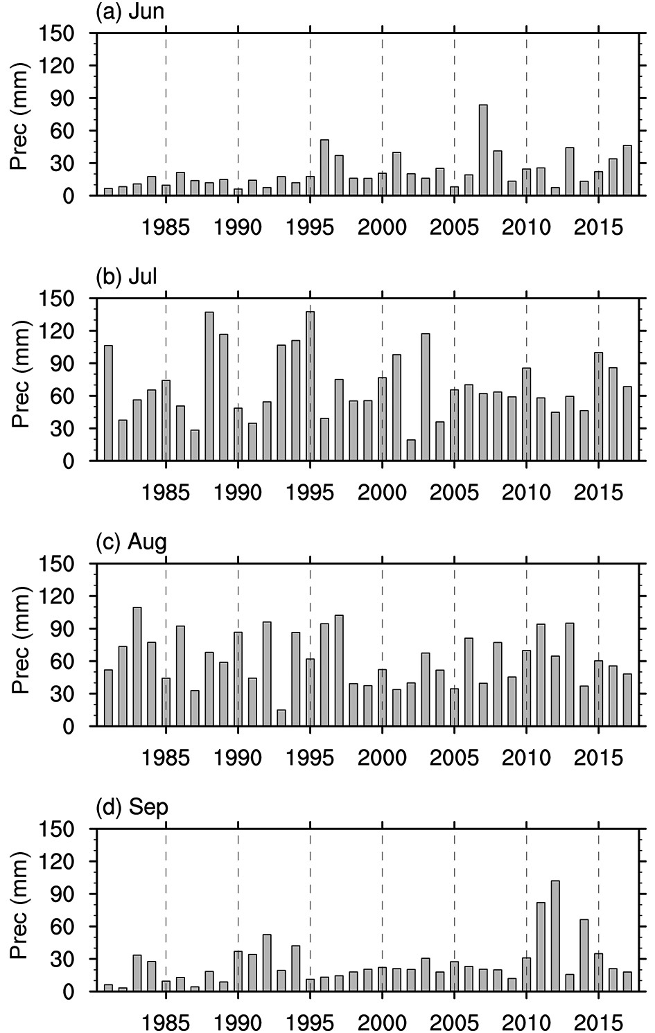 Figure1. Interannual variations of station-averaged monthly precipitation (unit: mm) in Pakistan for (a) June, (b) July, (c) August and (d) September.
Figure 2 shows the 200-hPa horizontal wind anomalies regressed onto monthly Pakistan rainfall each month from June. There is a significant anticyclonic anomaly to the northwest of Pakistan for all three months from June to August. This is consistent with previous studies, which reported that the upper-tropospheric anticyclonic anomaly over West Asia is related to more precipitation in Pakistan or India during summer (e.g., Kripalani et al., 1997; Wu, 2002, 2017). However, the September precipitation corresponds to weak circulation anomalies to the northwest of Pakistan (Fig. 2d), or in other words, the anticyclonic anomaly over this region appearing in the preceding months (Figs. 2a-c) is almost invisible in September (Fig. 2d). We have also analyzed the composite circulation anomalies in the excessive and deficient rainfall years, respectively, for each month from June to September, and found that there is an anticyclonic anomaly over West Asia in excessive years and a cyclonic anomaly in deficient years for each month from June to August, but the wind anomalies are weak in both the excessive and deficient years for September (not shown), consistent with the regression results.
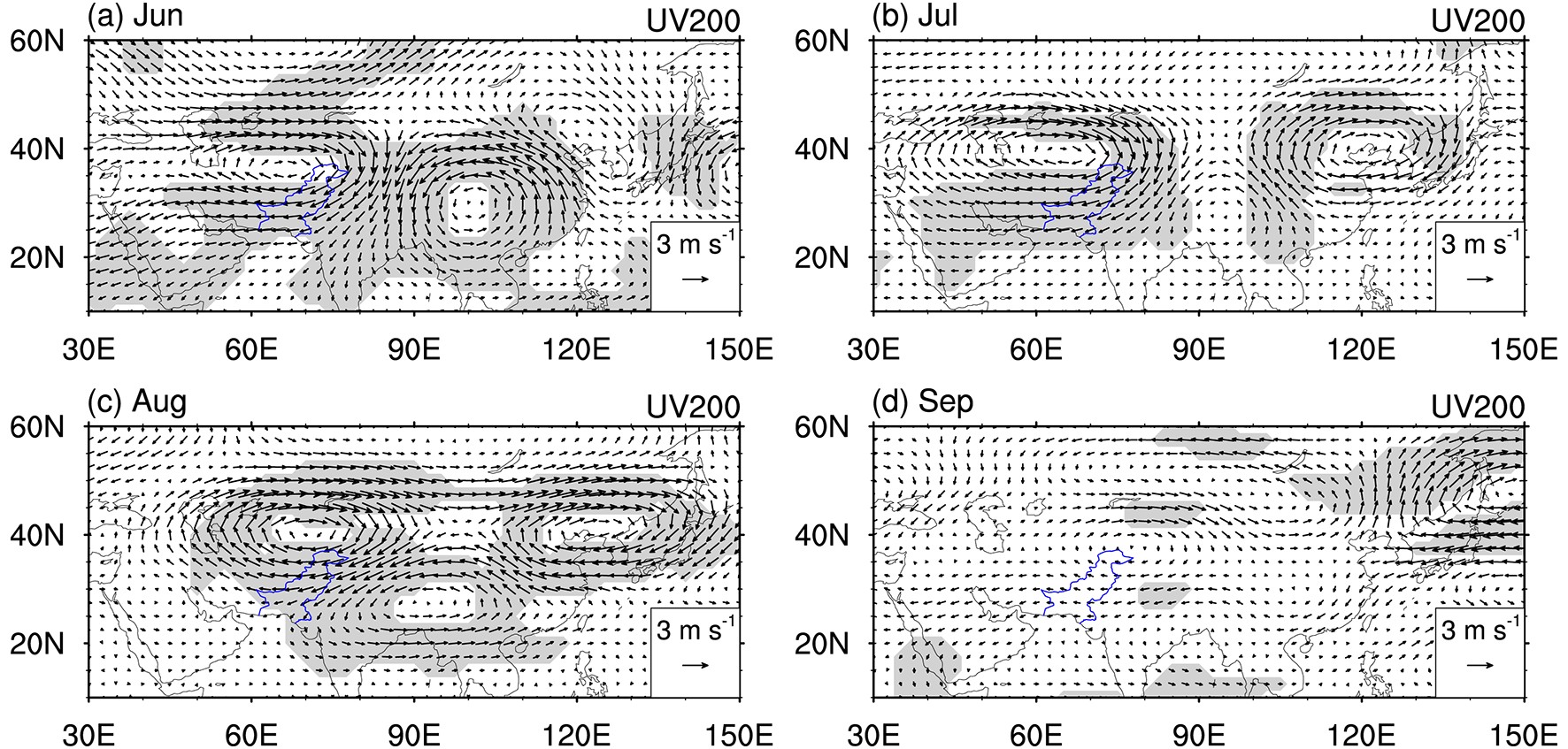 Figure2. 200-hPa horizontal wind anomalies (vectors; units: m s?1) regressed onto the standardized monthly Pakistan rainfall for (a) June, (b) July, (c) August and (d) September. Shading indicates zonal or meridional wind anomalies significant at the 0.05 level based on the Student’s t-test.
In addition to the anticyclonic anomaly over West Asia, an anomalous anticyclone appears over East Asia for all the months from June to August. A cyclonic anomaly appears between these two anticyclonic anomalies, but exhibits apparent changes in shape and location from month to month. Despite the monthly changes, the circulation anomalies over the Eurasian continent generally resemble the CGT or SRP, confirming the relationship between these teleconnection patterns and Pakistan rainfall. In September, there is no clear teleconnection pattern along the Asian jet (Fig. 2d), again showing a distinct change compared to the preceding months.
Figure 3 shows the lower-tropospheric wind anomalies and moisture flux divergence regressed on the standardized monthly Pakistan rainfall from June to September. There is a cyclonic anomaly to the south of Pakistan associated with increased June, July and August rainfall (Figs. 3a-c), indicating a strengthened monsoon trough and more water vapor transport into Pakistan as a result. This is further confirmed by the moisture flux divergence integrated from 925 to 600 hPa regressed onto the standardized monthly Pakistan rainfall. There are negative anomalies, which represent inward flux of moisture, over most regions of Pakistan, particularly over the southern part of the country. Weak outward moisture flux appears over the central-north region of Pakistan, which is inconsistent with heavier rainfall. This discrepancy is possibly due to the errors of moisture flux in the reanalysis data related to topographic effects, and needs more investigation. Associated with the cyclonic circulation anomaly, significant easterly anomalies appear over Pakistan. The monthly circulation anomalies are similar to the vertically integrated water vapor transport anomalies shown in Ullah and Gao (2012, their Fig. 2), who contrasted two typical years (wet year of 1994 vs dry year of 2002). Note that the anomalous moisture fluxes integrated from 925 to 600 hPa (not shown) have almost the same directions as the 700-hPa anomalous winds from June to August, suggesting that the winds play a crucial role in inducing the moisture fluxes. For September, by contrast, the cyclonic anomaly shifts westwards, the wind anomalies are much weaker over Pakistan, and the inward flux of moisture is also much weakened and appears hardly significant over the southern part of Pakistan. These suggest that the wind and moisture transport anomalies associated with monthly rainfall variability in September are distinct from the other three months, i.e., June, July, and August.
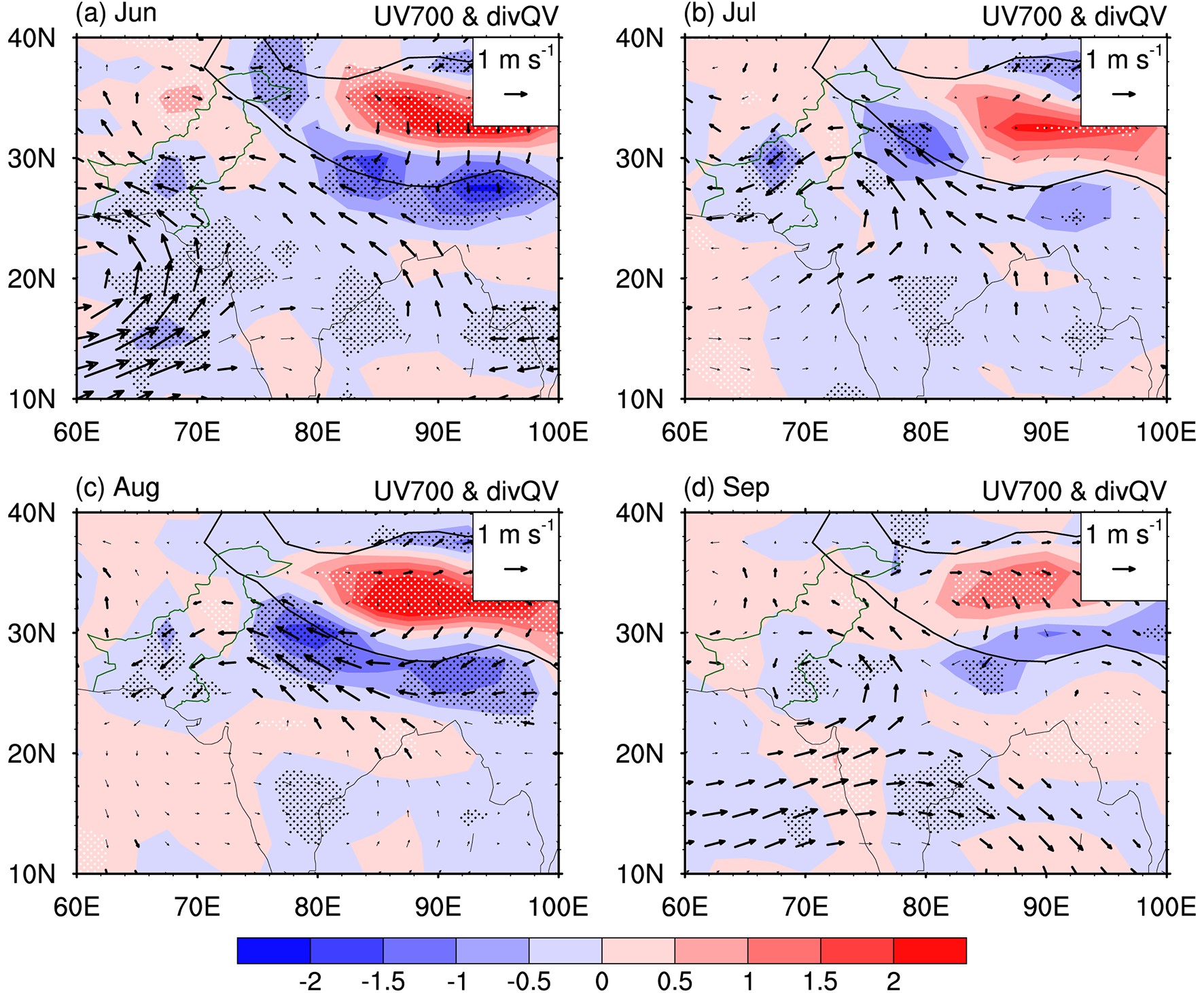 Figure3. 700-hPa horizontal wind anomalies (vectors; units: m s?1) and the moisture flux divergence integrated from 925 to 600 hPa (shading; units: 10?6 kg m?2 s?1) regressed onto the standardized monthly Pakistan rainfall for (a) June, (b) July, (c) August and (d) September. The blue and red shading indicates anomalous convergence and divergence of the moisture flux, respectively, and the dots represent the regions significant at the 0.05 level based on the Student’s t-test. The zonal or meridional wind anomalies significant at the 0.05 level are emboldened. The solid lines delineate the topography of 3000 m.
The time series of standardized JJA-average precipitation variation (PKprec) is shown in Fig. 4a. Figure 5 shows the horizontal wind anomalies in the upper and lower troposphere regressed onto PKprec. Both the upper-tropospheric anticyclonic anomaly to the northwest of Pakistan and the lower-tropospheric cyclonic anomaly to the south of Pakistan tend to be clearer in comparison with the anomalies associated with monthly precipitation (Figs. 2 and 3). The anticyclonic anomaly in the upper troposphere is also manifested as a component of the SRP, and the cyclonic anomaly over central Asia tends to be weaker and southward-shifted in comparison with the anticyclonic anomalies over West Asia and East Asia (Fig. 5a), somewhat similar to the monthly results for June, July and August (Figs. 2a-c). On the other hand, in the lower troposphere, the significant easterly anomalies at the southern side of the Tibetan Plateau and moisture transport into the southern part of Pakistan are associated with the cyclonic anomaly to the south (Fig. 5b). We have also analyzed the composite wind anomalies for the above-normal and below-normal precipitation years, respectively, and found that the results show approximately out-of-phase circulation patterns and similar circulation intensities in both the upper and lower troposphere (figures not shown, but can be partially found in Figs. 4b and c), suggesting a general linear relationship between the Pakistan summer precipitation with the upper-tropospheric anticyclonic/cyclonic anomaly to the northwest of Pakistan and the lower-tropospheric easterly/westerly anomaly over Pakistan.
In the following we use the upper-tropospheric anticyclonic anomaly and lower-tropospheric easterly anomaly to represent the typical circulation anomalies responsible for more rainfall in Pakistan, and accordingly define two indexes. The anticyclonic anomaly index (ACI) is defined as the 200-hPa vorticity anomalies averaged over the region (35°?45°N, 55°?80°E) and multiplied by minus one so positive values correspond to anticyclonic flow. In addition, the easterly anomaly index (EASTI) is defined as the 700-hPa zonal wind anomalies averaged over the region (25°?35°N, 60°?80°E) and likewise multiplied by minus one so positive values correspond to easterly flow. Note that these two regions do not overlap. The time series for these indices are included in Fig. 4a, and they are both significantly correlated to the Pakistan rainfall index. The correlation coefficients between the ACI/EASTI and Pakistan rainfall index are 0.39/0.67, significant at the 0.05 and 0.01 level, respectively. The higher correlation with the lower-tropospheric circulation index implies the crucial role of moisture transport in affecting the Pakistan summer rainfall. Scatterplots between the Pakistan rainfall index with both the ACI (Fig. 4b) and EASTI (Fig. 4c) also confirm the close relationship between the rainfall and upper- and lower-tropospheric circulation anomalies: Most dots (26 in Fig. 4b and 30 in Fig. 4c out of 37) are scattered in the first and third quadrants. In Fig. 4c, particularly, there is not a dot in the second quadrant, and the EASTI is weak (lower than 0.5 standard deviations) in the fourth quadrant, confirming the close relationship between the Pakistan rainfall and lower-tropospheric wind anomalies. On the other hand, the ACI and EASTI also have a significant relationship with each other (Fig. 4d), with the correlation efficient being 0.49. This suggests a vertical coupling between the larger-scale upper- and lower-tropospheric anomalies, possibly via vertical motion and diabatic heating associated with the rainfall anomalies, although we cannot strictly exclude the possibility that the relationship is induced by other unknown factor(s).
Figure 6 shows the spatial distributions of station rainfall anomalies regressed onto the standardized time series of the ACI, EASTI and Pakistan rainfall index, respectively. The ACI is positively related to precipitation over most stations (Fig. 6a). Particularly, the six stations with a significant (0.05 level) relation all have positive regression. The nine stations with negative relation are all in northern and central Pakistan, where rainfall is relatively weak. By contrast, the EASTI is more clearly related to the station rainfall and there is only one station showing a negative relationship (Fig. 6b), in agreement with the higher correlation coefficient between the EASTI and Pakistan rainfall index. The Pakistan rainfall index is positively correlated with rainfall at almost all the stations, and there are only five stations showing an insignificant relationship.
 Figure6. Rainfall anomalies (units: mm d?1) at the stations used in this study regressed onto the standardized time series of the (a) ACI, (b) EASTI and (c) Pakistan rainfall index. The definitions of these three indexes can be found in the text. Solid dots indicate anomalies significant at the 0.05 level.
Figure 7 shows the horizontal wind anomalies at 200 and 700 hPa regressed onto the standardized ACI. The anticyclonic anomaly to the northwest of Pakistan at 200 hPa is stronger and more significant (Fig. 7a), in comparison with that associated with the Pakistan rainfall index (Fig. 5a). Correspondingly, the SRP is clearer, manifested as the anticyclonic anomalies over West Asia and East Asia and the cyclonic anomaly over central Asia. The meridional wind anomalies associated with these anticyclonic and cyclonic anomalies exhibit alternately southerly and northerly anomalies along the Asian upper-tropospheric westerly jet.
 Figure7. As in Fig. 5 but for anomalies regressed onto the standardized ACI.
On the other hand, the ACI is associated with the significant easterly anomalies in the lower troposphere at the southern side of the Tibetan Plateau (Fig. 7b). The relationship between the ACI and lower-tropospheric easterly anomalies suggests a vertical coupling of circulation anomalies over South Asia. The correlation coefficient between the ACI and EASTI is 0.49, significant at the 0.01 level, confirming the vertical coupling. However, we could not find a clear cyclonic anomaly to the south of Pakistan, which appears in the anomalies regressed onto the Pakistan rainfall index (Fig. 5b), and the anomalous moisture transport into Pakistan (Fig. 7b) seems to be weaker than that related to the Pakistan rainfall (Fig. 5b).
Figure 8 shows the horizontal wind anomalies at 200 and 700 hPa regressed onto the EASTI. The EASTI-related wind anomalies in the upper troposphere (Fig. 8a) are similar to those associated with the Pakistan rainfall index (Fig. 5a), and tend to be more significant. In particular, there is a significant anticyclonic anomaly to the northwest of Pakistan. This anticyclonic anomaly resembles that associated with the ACI (Fig. 7a), but extends southwestward into North Africa. Therefore, the southerly anomaly associated with this anticyclonic anomaly appears over the Mediterranean Sea, rather than over the Caspian Sea like the ACI-related anomalies. The southerly or northerly anomalies centered at the Caspian Sea are a typical feature of the SRP, and thus it can be inferred that the SRP is more closely related to the ACI than the EASTI. Another remarkable difference with the ACI-related anomalies is that there is a strong and significant cyclonic anomaly over southern and central China. In the lower troposphere, the EASTI is more closely related to the cyclonic anomaly over the Arabian Sea and Indian subcontinent, and a clear branch of moisture transport related to this cyclonic anomaly appears (Fig. 8b), in comparison with those associated with the ACI (Fig. 7b) and Pakistan rainfall index (Fig. 5b).
 Figure8. As in Fig. 5 but for anomalies regressed onto the standardized EASTI.
The above results suggest that there may be a vertical coupling between the upper- and lower-tropospheric circulation anomalies. In the following, we further investigate the vertical structure of circulation anomalies associated with Pakistan rainfall variability. Figure 9 shows a latitude?height cross section of zonal wind anomalies averaged over 60°?80°E, regressed onto the standardized time series of Pakistan rainfall index, ACI and EASTI, respectively. The zonal winds can depict well both the anticyclonic anomaly in the upper troposphere and easterly anomaly in the lower troposphere. Above-normal rainfall in Pakistan is associated with easterly anomalies approximately over 25°?35°N and westerly anomalies over 40°?50°N (Fig. 9a). These zonal wind anomalies are strongest at about 200 hPa, and roughly in a barotropic structure, but with a northward tilt with height. The easterly anomalies extend to the surface, confirming that the easterly anomalies along the foothills of the Himalayas favor more rainfall in Pakistan. The ACI corresponds to a similar distribution of zonal wind anomalies (Fig. 9b). These anomalies also tilt northward with height, but the westerly anomalies tend to tilt southwards in the lower troposphere. The easterly anomalies also tend to tilt southwards in the lower troposphere, but note that these anomalies may be artificial due to the plateaus over 30°?40°N. In addition, the easterly anomalies are mainly concentrated in the upper troposphere, and decrease sharply in the lower troposphere, especially when compared with the anomalies associated with the Pakistan rainfall index. The ACI-related easterly anomalies at 200 hPa are roughly two times larger than those associated with the Pakistan rainfall index, but at 700 hPa the former are smaller than the latter. The EASTI-related anomalies (Fig. 9c) are similar to those associated with the Pakistan rainfall (Fig. 9a), but they are relatively stronger throughout the entire troposphere, which is consistent with the fact that the EASTI is more highly correlated with the ACI than the Pakistan rainfall index (correlation coefficients 0.49 vs 0.39). In addition, there are westerly anomalies over 10°?20°N, and they are limited basically below the mid troposphere, suggesting the existence of significant cyclonic anomalies to the south of Pakistan. Despite the existence of differences, all the vertical structures of zonal wind anomalies shown in Fig. 9, particularly the easterly anomalies, suggest a vertical coupling, i.e., there is a close relationship in the vertical direction.
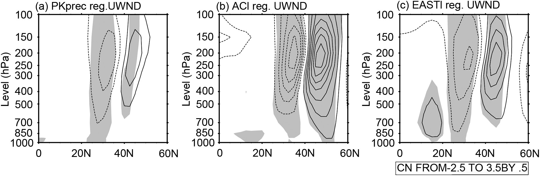 Figure9. Latitude?height cross section of zonal wind anomalies (contours; units: m s?1) regressed onto the standardized time series of the (a) Pakistan rainfall index, (b) ACI and (c) EASTI. These anomalies are averaged over 60°?80°E. Contour intervals are 0.5 m s?1, and zero contours are omitted. Shading indicates anomalies significant at the 0.05 level.
5.1. Conclusions
In this study, we investigate the circulation anomalies associated with interannual variations of Pakistan rainfall during summer. It is found that wind anomalies associated with Pakistan monthly rainfall are similar between June, July and August, in both the upper and lower troposphere. Therefore, we focus on the summer-mean (i.e., JJA mean) results.The results indicate that more Pakistan summer rainfall is significantly associated with an upper-tropospheric anticyclonic anomaly to the northwest of Pakistan and lower-tropospheric easterly anomalies along the foothills of the Himalayas, including Pakistan. The lower-tropospheric easterly anomalies, in comparison with the upper-tropospheric anticyclonic anomaly, show a closer relationship with Pakistan rainfall, suggesting the important role of lower-tropospheric zonal wind anomalies in affecting rainfall through modulating water vapor transport. These upper- and lower-tropospheric circulation anomalies also show a close relationship, and the vertical section of anomalies indicates a roughly barotropic structure throughout the entire troposphere.
On the other hand, the upper- and lower-tropospheric anomalies show separate features. The upper-tropospheric anticyclonic anomaly is closely related to the SRP along the upper-tropospheric Asian jet and the easterly anomalies along the foothills of the Himalayas, but not to the lower-tropospheric cyclonic anomaly to the south of Pakistan. By contrast, the lower-tropospheric easterly anomalies are closely related to the cyclonic anomaly to the south of Pakistan, but do not correspond well to the SRP, although showing a close relationship to the upper-tropospheric anticyclonic anomaly. Thus, attention should also be paid to different physical mechanisms responsible for these upper- and lower-tropospheric circulation anomalies associated with Pakistan rainfall.
2
5.2. Discussion
35.2.1. Comparison with flooding in 2010
An unusually heavy rainfall event occurred during late July to early August 2010 in Pakistan, causing tremendous disasters, including widespread landslides, and a death toll of nearly 3000 in the country. The event triggered many studies (Hong et al., 2011; Galarneau et al., 2012; Lau and Kim, 2012; Ullah and Gao, 2012; Martius et al., 2013; Rasmussen et al., 2015), the results of which suggest that this heavy rainfall event came about due to a combination of upper-tropospheric extratropical Rossby waves and lower-tropospheric monsoonal depressions. However, as noted by Wang et al. (2011), a cyclonic anomaly appeared to the northwest of Pakistan in the upper troposphere during the Pakistan flood period in summer 2010, in sharp contrast to the anticyclonic anomaly associated with more summer rainfall in Pakistan on the interannual time scale shown by previous studies (e.g., Syed et al., 2012; Wu, 2017) and the present study. In our analysis, the upper-tropospheric ACI has its largest negative value in 2010 in the 1981?2017 analysis period (see Fig. 4), confirming the existence of a cyclonic anomaly to the west of Pakistan in summer 2010.Such a discrepancy may be attributable to differences in time scales. The flooding during summer 2010 essentially was caused by synoptic events with time scales of days, while in this study we focused on the interannual variability of monthly or seasonal rainfall. The rains that caused the flooding do not contribute much to the monthly precipitation in Pakistan, as can be seen from the slightly above-normal July and August 2010 rainfall in Fig. 1. Moreover, as mentioned by Webster et al. (2011), there were some other factors resulting in the devastating flooding of summer 2010, in addition to the fact that rainfall was high, but not unexceptionally so. These factors include the precursory severe drought and resultant sparser vegetation during 2010, deforestation in northern Pakistan, and the concurrence between heavy rainfall and the mountainous region. Furthermore, the flooding during summer 2010 tended to appear over a limited spatial scope, which can be supported by the findings of Vellore et al. (2016): 34 extreme rainfall events occurred in the northwest region of India, which is the eastern neighbor of Pakistan, were selected in their study, but none of them occurred during summer 2010.
3
5.2.2. Subseasonal change
The similarity of circulation anomalies associated with monthly Pakistan rainfall from June to August, shown in Figs. 2 and 3, suggests that the relationship between circulation and rainfall is stable during summer. However, there are also some appreciable differences in the monthly relationship between circulation and rainfall, including that the upper-tropospheric cyclonic anomaly over southern China is strong in June and August but weak in July, and the lower-tropospheric cyclonic anomaly to the south of Pakistan is strongest in June but weakest in August. These monthly differences suggest that there would be a subseasonal change in the relationship between circulation and Pakistan rainfall.In the following, we further discuss the subseasonal difference based on a comparison with the results of Wang et al. (2019), who identified a negative relationship in July?August precipitation between the southeastern Tibetan Plateau and Pakistan on the interannual time scale, and suggested that the former affects the latter. Figure 10 shows that in July and August a negative rainfall anomaly appears over the southeastern Tibetan Plateau, corresponding to more rainfall in Pakistan, consistent with Wang et al. (2019), but the rainfall anomaly is weak in June. Thus, this difference in rainfall anomaly over the southeastern Tibetan Plateau may partially explain the monthly different circulation anomalies associated with Pakistan rainfall, and there would be other influencing factor(s), especially for June. In summary, the subseasonal difference in the relationship between rainfall variability over Pakistan and circulation anomalies should be further investigated.
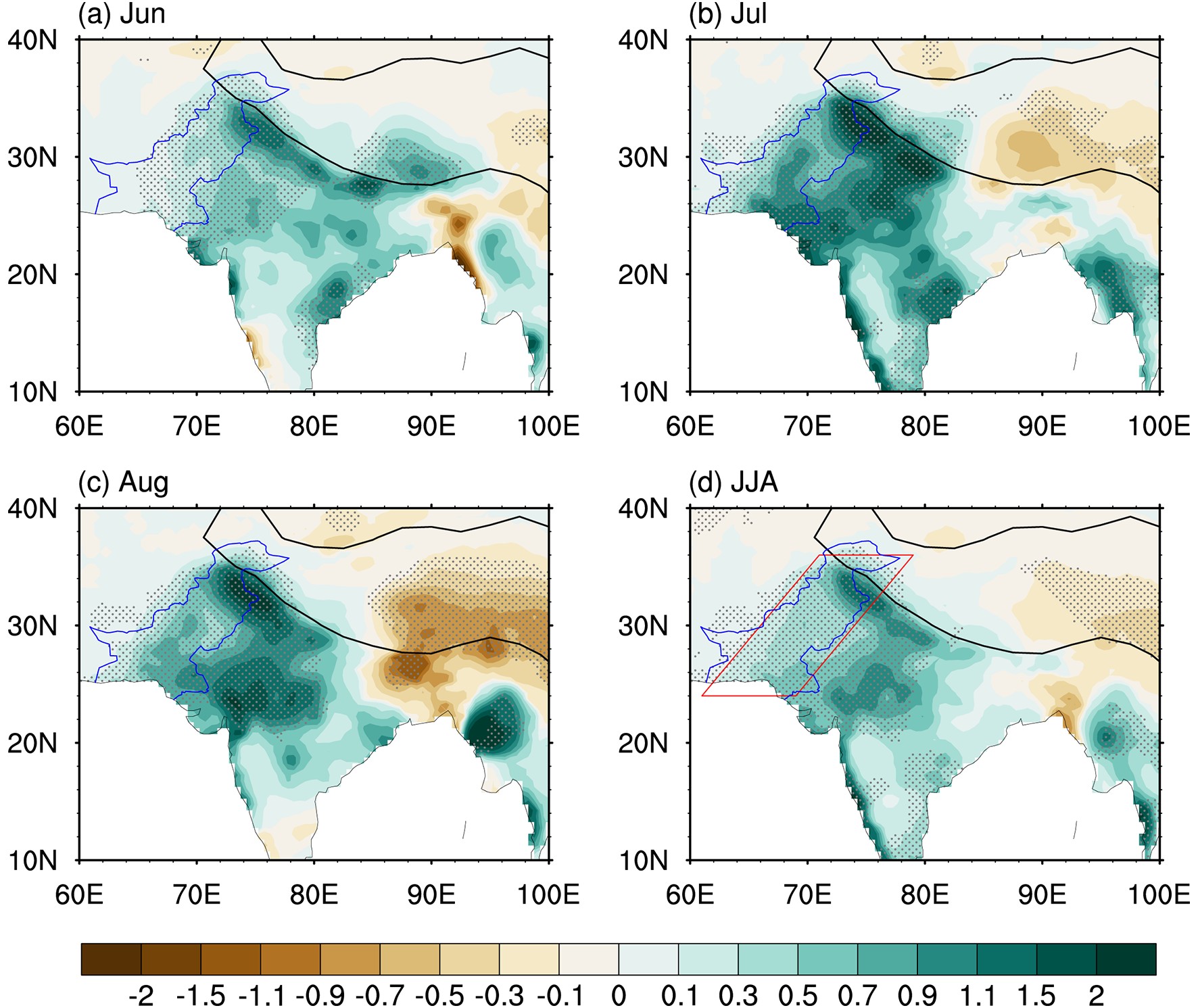 Figure10. CRU rainfall anomalies (shading; units: mm d?1) regressed onto the standardized time series of the Pakistan rainfall index in (a) June, (b) July, (c) August, and (d) JJA. Marked areas indicate anomalies significant at the 0.05 level, and solid lines delineate the topography higher than 3000 m. The red parallelogram in (d) is used to obtain the domain-averaged precipitation anomalies, in order to calculate its temporal correlation coefficient with the Pakistan station rainfall.
3
5.2.3. Vertical coupling
In this study, we suggest that both the upper- and lower-tropospheric circulation anomalies are crucial in affecting Pakistan summer rainfall. These circulation anomalies are related to each other through vertical coupling. Regarding the causality between the upper-tropospheric anticyclonic anomaly and lower-tropospheric easterly anomalies, we incline to the view that the former affects the later, considering that the former can be induced by the upstream circulation anomalies which are associated with the SRP. However, caution should be applied to any conclusion on causality. First, the upper-tropospheric anticyclonic anomaly and lower-tropospheric easterly anomalies show some unique features, suggesting that they might be affected by different factors. The upper-tropospheric anomalies tend to be more closely related to the extratropical circulation anomalies over the Eurasian continent, while the lower-tropospheric ones more closely related to the tropical or monsoonal anomalies. Second, the anomalous rainfall, as a diabatic heating forcing, may in turn have a feedback to the upper- and lower-tropospheric circulation anomalies.The large-scale circulation anomalies associated with Pakistan summer rainfall can be helpful for an understanding of the predictability of rainfall. On the one hand, the upper-tropospheric anomalies, which are related to the extratropical SRP, might be of low predictability (Kosaka et al., 2012). On the other hand, the more influential lower-tropospheric easterly anomalies are in the tropical regions and thus may be of greater predictability. The predictive relation between circulation factors such as the EASTI and ACI and Pakistan summer rainfall would be an interesting topic for further investigation.
3
5.2.4. Other issues
Although this study focuses on the rainfall variation in Pakistan, the results can be extended to Northwest India. On the one hand, Pakistan rainfall is closely associated with rainfall anomalies in Northwest India, in each month of summer and in terms of the summer mean (Fig. 10). On the other hand, various previous studies have indicated that the SRP or CGT can influence rainfall in Northwest India, as well as in Pakistan (e.g., Kripalani et al., 1997; Wu, 2002, 2017; Ding and Wang, 2005; Syed et al., 2012).In addition, there is good agreement between the CRU precipitation data and Pakistan station rainfall data, which can be found in Fig. 10. This consistency between the two datasets can be further confirmed by the high correlation coefficients between them. We used the parallelogram in Fig. 10d to represent Pakistan rainfall in the CRU precipitation data and obtained the correlation coefficients between the two datasets: 0.77 for June, 0.88 for July, 0.81 for August, and 0.90 for JJA. This result suggests that both datasets are reliable for investigating the interannual variability of precipitation in Pakistan.
Situated at the northernmost edge of the Asian monsoonal region and to the south of the Asian upper-tropospheric westerly jet, Pakistan experiences complex climate variability in summer, and further studies on Pakistan’s climate variability may be of great help towards a better understanding of tropical?extratropical interaction related to the strongest monsoon (i.e., Asian summer monsoon) in the world.
Acknowledgements. We sincerely thank the Executive Editor-in-Chief, anonymous reviewers and Editor, who gave us insightful and constructive comments and suggestions. This research was jointly sponsored by the National Natural Science Foundation of China (Grant Nos. 41705044 and 41721004), the Joint Open Project of KLME and CIC-FEMD (Grant No. KLME20 1802), and the second Tibetan Plateau Scientific Expedition and Research (STEP) Program (Grant No. 2019QZKK0102).
