 ,, 戴全厚,, 甘艺贤, 高儒学, 严友进, 王玉红贵州大学林学院,贵阳550025
Effects of Rainfall Intensity and Underground Hole (Fracture) Gap on Nutrient Loss in Karst Sloping Farmland
YAO YiWen,, DAI QuanHou,, GAN YiXian, GAO RuXue, YAN YouJin, WANG YuHongCollege of Forestry, Guizhou University, Guiyang 550025通讯作者:
责任编辑: 李云霞
收稿日期:2020-04-20接受日期:2020-09-2网络出版日期:2021-01-01
| 基金资助: |
Received:2020-04-20Accepted:2020-09-2Online:2021-01-01
作者简介 About authors
姚一文,E-mail:

摘要
关键词:
Abstract
Keywords:
PDF (994KB)元数据多维度评价相关文章导出EndNote|Ris|Bibtex收藏本文
本文引用格式
姚一文, 戴全厚, 甘艺贤, 高儒学, 严友进, 王玉红. 雨强和地下孔(裂)隙度对喀斯特坡耕地养分流失的影响[J]. 中国农业科学, 2021, 54(1): 140-151 doi:10.3864/j.issn.0578-1752.2021.01.010
YAO YiWen, DAI QuanHou, GAN YiXian, GAO RuXue, YAN YouJin, WANG YuHong.
开放科学(资源服务)标识码(OSID):

0 引言
【研究意义】以贵州省为中心的西南喀斯特区是全球三大岩溶最为集中、发育最为强烈的典型生态脆弱区[1]。坡耕地是该地区重要的耕地资源,由于频繁耕作和不科学的土地管理措施导致水土流失严重使坡耕地土壤肥力及土地生产力下降[2,3]。大量的水土流失使土壤养分通过径流、泥沙等方式流入河流水库,造成地表水体富营养化[4]。此外,土壤养分还会通过沿岩溶孔(裂)隙、漏斗、落水洞等向地下流失[5]。因此,通过人工降雨试验,研究不同雨强和地下孔(裂)隙条件下坡耕地土壤养分流失状况,为喀斯特坡耕地土壤养分流失控制和农业面源污染防治提供理论基础和技术支撑。【前人研究进展】认识坡耕地养分流失规律,减少坡耕地土壤养分流失成为近年来学术界研究的热点。国外****[6]利用同位素示踪等技术对氮元素流失路径进行研究,通过利用短脉冲[7]、示踪剂[8]等方法研究喀斯特区表层岩土界面污染物运移状况;国内****通过室内模拟降雨,研究土壤养分流失机理,发现各养分流失与雨强均呈现一定的相关性[9,10]。郑子成等[11]发现喀斯特坡耕地坡面产流量和坡度与磷素流失总量呈显著正相关,王全九等[12]通过调节雨滴下落高度,研究雨滴动能对土壤钾随地表径流迁移的影响。还有****通过对野外坡耕地养分流失长期定位监测,发现全钾易溶于水,容易随地表径流流失,而全磷易附着于土壤颗粒随泥沙流失[13]。总体而言,已有研究大部分主要针对喀斯特区坡耕地地表养分流失的探究,对该地区独特地表-地下二元空间结构[14]中坡耕地坡面地下养分流失仅处于初步探索阶段,缺乏在二元结构下土壤养分流失的系统研究。【本研究切入点】坡耕地作为我国西南喀斯特地区重要的耕地资源,由于坡耕地下的伏基岩以碳酸盐岩为主,在溶蚀作用下表层岩溶带溶蚀会形成不同形态的裂隙所组成的地下岩溶管道,使坡耕地养分不光通过地表流失,还通过此类通道向地下流失。但该地区复杂的地下构造使得对土壤养分流失研究方法受限,研究结果具有一定差异。故通过模拟不同雨强和地下孔(裂)隙度深入系统地研究喀斯特坡耕地在短历时降雨条件下土壤养分流失的过程及作用机制。【拟解决的关键问题】通过模拟喀斯特坡耕地地表微地貌及地下孔(裂)隙双层空间构造特征,利用可调节降雨强度和地下孔(裂)隙度的人工降雨装置,研究雨强和地下孔(裂)隙度对喀斯特坡耕地土壤侵蚀、土壤养分流失量、土壤养分流失途径的影响,将有助于明确坡耕地土壤养分流失特征和主要途径流失,为喀斯特地区坡耕地养分流失控制和农业面源污染控制具有重要的参考作用。1 材料与方法
1.1 试验土样及设备
试验土壤采自贵州省贵阳市花溪区喀斯特坡耕地(26°19′17″N、106°39′18″E)0—30 cm土层由碳酸盐岩发育形成的石灰土[15],土壤基本性质如表1所示。花溪区石灰土面积占全区土壤面积的37.4%[16],因此土壤具有一定的典型性。试验土壤不过筛,首先剔除动植物残体及较大石块,然后对较大的土壤团块进行分散处理,待风干后,混合均匀后备用。Table 1
表1
表1供试土壤基本性质
Table 1
| 颗粒组成Particle composition (%) | 养分Nutrient | ||||
|---|---|---|---|---|---|
| 砂粒 Sand (0.02-2 mm) | 粉粒 Silt (0.002-0.02 mm) | 黏粒 Clay (<0.002 mm) | 全氮TN (g·kg-1) | 全磷TP (g·kg-1) | 全钾TK (g·kg-1) |
| 37.34 | 47.53 | 15.00 | 1.72±0.11 | 1.69±0.10 | 8.47±0.06 |
新窗口打开|下载CSV
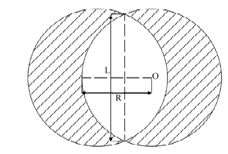
试验设备由可调孔(裂)隙度的变坡钢槽[17]和QYJY-501(502)便携式全自动下喷式人工降雨器两部分组成(图1),降雨器降雨高度6 m,雨滴终点速度满足天然降雨特性,雨强可遥控调节,其变化范围为10—200 mm·h-1,调节变化时间低于30 s,调节精度为7 mm·h-1,降雨有效范围6.5 m×6.5 m,均匀度>85%。在土槽两侧放置两个雨量筒以校验本次试验的实际雨强。可调孔(裂)隙度的变坡钢槽长宽深分别为4、1.5和0.35 m,坡度在0—45°可调,钢槽底部为两块可活动且带有均匀打孔的钢板组成,每块钢板的孔直径和数量分别为5 cm、192个。钢槽下端分别设有地表、地下孔隙流集流槽,集流槽出水口下方采用塑料小桶收集径流泥沙样,其中为雨水通过两块穿孔钢板孔洞错开的空间向下流到钢板上,再通过集流槽流入地下径流桶中的为地下孔隙流。地下孔(裂)隙度的大小通过钢槽底部上下两块钢板间孔洞的重合面积进行调节,范围在0—8%任意可调,其中上下两块钢板间孔洞完全重合时地下孔(裂)隙度最大,两块钢板的孔洞完全错开时最小。地下孔(裂)隙度调节方法为:先通过计算得到地下孔(裂)隙度在设计水平时底板孔洞重合区域的最大弦长,通过摇臂调节孔洞重合区域弦长至设计水平。地下孔(裂)隙度计算公式、示意图见公式(1)、(2)和图2。
式中,P为地下孔(裂)隙度(%);π为圆周率,取3.14;S孔为孔洞重合区域的面积(m2);R为底板孔洞半径(m),0.025 m;L为孔洞重合区域最大弦长(m);S钢板为钢板的面积(m2),6 m2。
图1
 新窗口打开|下载原图ZIP|生成PPT
图1试验装置示意
Fig. 1Sketch of the experimental apparatus
图2
 新窗口打开|下载原图ZIP|生成PPT
图2地下孔(裂)隙度调节示意图[18]
O为圆心,R为半径,L为弦长
Fig. 2Layout of underground hole (crack) regulation
O stands for center of the circle,R for radius, L for chord length
1.2 试验设计
根据前期研究结果[19]发现贵州省喀斯特坡耕地的基岩裸露率在10%—30%、坡度在10°—25°内,地下孔(裂)隙度最大为5.98%。采用15°为试验坡度,基岩裸露率20%。雨强和孔(裂)隙度为本试验的控制因子,雨强设置是根据张文源等[20]提出喀斯特坡耕地侵蚀性降雨指标,并结合近年来贵州省的降雨特征划分为4个降雨强度,其中小雨强(30 mm·h-1),中雨强(50、70 mm·h-1),大雨强(90 mm·h-1)3个等级;通过钢槽底部均匀打孔来模拟喀斯特岩溶裂隙,地下孔(裂)隙度为地下裂隙水平投影面积与钢槽底板面积的百分比,分为3个等级,地下孔(裂)隙度1%为微度发育,地下孔(裂)隙3%为轻度发育,地下孔(裂)隙5%为中度发育,两者进行交叉试验,每个处理重复3次,共计36场降雨。为模拟喀斯特缓坡耕地自然坡面,选择直径≥35 cm的石灰岩块石随机排列在钢槽内并标记出30 cm以上部分露头面积,使块石30 cm以上部分的岩石裸露率达到试验标准,然后装填土壤,钢槽填土厚度为30 cm,按10 cm为一层共3层,自下而上按野外实测土壤紧实度分层装填土壤,其土壤紧实度平均值依次为1 070、760、410 kPa。表土用特制木板拨平,压实填土边缘以减少边界效应影响,土壤和岩石达到设计水平后,用数码相机垂直拍摄坡面照片并利用ArcGIS校核坡面岩石裸露率使其达到试验标准[21]。试验开始前先将钢槽调到试验要求坡度后,用15 mm·h-1的雨强进行沉降,使坡面土壤含水量达到饱和,待坡面出现产流后停止小雨沉降,静置,使土壤水在重力作用下自然滴落,10 min内不再下滴即可开始试验。当地表或地下开始产流后,每隔3 min用500 mL聚乙烯瓶收集径流水样,用于测定径流水样中TN、TP、TK含量,其余径流全部收集在径流大桶内,测定径流及泥沙量。每场降雨历时30 min,重复3次,每场降雨结束后更换土壤使其土壤含水量和容重等指标达到与上一场相同后再进行下一次降雨。试验于2017年9月在贵州大学人工模拟降雨大厅内进行。
1.3 样品分析
水样采集后现场加硫酸保存于4℃冰箱中,并在24 h内进行室内分析测定。水样中TP、TK浓度分别采用紫外分光光度法和原子吸收光谱仪法测定。泥沙中TP、TK浓度分别采用重铬酸钾硫酸消化法和火焰光度法测定。TP浓度采用钼锑抗比色法测定,具体操作方法参考国家环境保护总局《水和废水监测分析方法》[22]。测定试验用水养分含量作为空白样,径流养分的结果扣除该空白即为径流流失的养分含量。1.4 数据处理
采用Excel 2016进行数据整理和制表,SPSS 20.0统计分析。2 结果
2.1 喀斯特坡耕地产流产沙对雨强和地下孔(裂)隙度的响应
径流和泥沙作为土壤养分流失在两种载体,研究雨强和地下孔(裂)隙度对产流产沙的影响,能够深入了解喀斯特坡耕地土壤养分流失特征。雨强和地下孔(裂)隙度对喀斯特坡耕地地表、地下径流和泥沙的影响如表2所示。对径流量而言,小雨强(30 mm·h-1)下以地下径流为主;当雨强大于50 mm·h-1时地表开始产流,径流产生后随着降雨强度的增加而增加且各雨强之间径流量差异显著(P<0.05),说明喀斯特坡耕地表产流可能存在临界雨强,在30—50 mm·h-1之间。地下孔(裂)隙度与地表径流量呈现负相关,与地下径流量呈现正相关,且随地下孔(裂)隙度增加径流量差异逐渐明显。在大雨强(90 mm·h-1)下,孔(裂)隙度从1%增加到5%时,地表径流量减小了1.11%,而地下径流量增加了1.41%,地下径流量增加的幅度大于地表减少的幅度,即孔(裂)隙度越大对地下径流影响越大。Table 2
表2
表2喀斯特坡耕地产流产沙量特征
Table 2
| 指标 Index | 孔(裂)隙度 Fissure porosity (%) | 地表Surface | 地下Underground | ||||||
|---|---|---|---|---|---|---|---|---|---|
| 30 mm·h-1 | 50 mm·h-1 | 70 mm·h-1 | 90 mm·h-1 | 30 mm·h-1 | 50 mm·h-1 | 70 mm·h-1 | 90 mm·h-1 | ||
| 产流量Runoff yield | 1 | 0 | 59.15±3.57Ac | 88.35±4.42Ab | 111.24±5.56Aa | 27.78±1.67Cd | 36.63±1.83Bc | 49.26±2.46Bb | 56.06±3.38Ba |
| 3 | 0 | 58.74±3.54Ac | 69.18±3.46Bb | 84.59±4.23Ba | 34.55±2.08Bd | 41.15±2.06Bc | 47.66±2.38Bb | 62.46±3.77Ba | |
| 5 | 0 | 26.23±1.58Bc | 46.76±2.34Cb | 52.76±2.64Ca | 53.62±3.32Ad | 65.52±3.28Ac | 104.49±5.22Ab | 135.21±6.76Aa | |
| 产沙量Sediment yield | 1 | 0 | 32.84±1.98Ab | 47.31±2.37Aa | 48.93±2.45Aa | 4.84±0.29Bd | 6.31±0.32Bc | 7.82±0.39Ba | 7.08±0.43Cb |
| 3 | 0 | 16.56±1.00Bc | 24.22±1.21Bb | 41.61±2.08Ba | 5.02±0.30Bd | 6.85±0.34Bc | 8.45±0.42Bb | 11.73±0.71Ba | |
| 5 | 0 | 7.77±0.47Cc | 17.14±0.86Cb | 28.21±1.41Ca | 7.39±0.45Ad | 11.90±0.59Ac | 20.19±1.01Ab | 34.89±2.10Aa | |
新窗口打开|下载CSV
对泥沙量而言,在同孔(裂)隙度下,小雨强下(30 mm·h-1)地表不产沙,地下孔隙流作为侵蚀产沙的主要载体。当降雨强度为50 mm·h-1时,地表开始产沙,且单位面积产沙量随降雨强度增加而增大,表明喀斯特坡耕地土壤侵蚀过程是从地下漏失到地表流失。同雨强下,地表产沙量随孔(裂)隙度增大而减小,地下反之。对比地表地下产沙量发现,中、大雨强下地表产沙量占总产沙量比重较大,说明小雨强下土壤侵蚀以地下为主,中、大雨强下以地表为主。
2.2 径流养分输出特征
2.2.1 降雨强度对径流养分影响 喀斯特坡耕地土壤养分流失主要通过径流溶解和泥沙携带两种途径,其中径流养分流失分为地表、地下径流两种形式。通过对不同雨强下地表和地下径流养分变化分析汇聚成表3。结果发现,在30 min的降雨时间里,各养分浓度随时间变化呈现一定波动性,但均未表现出明显的初期冲刷效应。小雨强下(30 mm·h-1),土壤径流养分流失主要通过孔(裂)隙以地下漏失为主,当雨强大于50 mm·h-1,土壤养分则通过地表、地下两种形式流失,土壤养分流失量和养分流失模数随降雨强度增加而增加,且各雨强下TN、TP、TK流失量差异显著(P<0.05)。在中雨强(70 mm·h-1)下地表TN、TP、TK平均流失浓度分别为2.51、0.20、0.43 mg·L-1,3种者地下平均流失浓度依次为2.01、0.19、0.23 mg·L-1,地表径流流失浓度高于地下;大雨强(90 mm·h-1)下地表径流中TN、TP、TK流失模数分别是地下的2.8、3.2、3.7倍,大雨强下三者地表养分流失量占其总量比例分别为TN(73.95%)、TP(76.10%)、TK(78.55%),说明在30 min短历时降雨情况下,土壤养分流失主要以地表流失为主,径流中全氮平均流失浓度、流失量和养分流失模数均高于全磷和全钾,全磷在地表、地下径流中浓度和流失量均较低,表明磷素很难被水溶解带离土壤;全钾地表径流与地下径流流失量差异较大,地表平均流失量是地下的2.6倍。Table 3
表3
表3不同雨强下地表、地下径流养分流失状况
Table 3
| 养分 Nutrient | 降雨强度 Rainfall intensity (mm·h-1) | 地表径流Surface runoff | 地下径流Underground runoff | 地下流失比 Underground loss ratio (%) | ||||
|---|---|---|---|---|---|---|---|---|
| 平均流失浓度 Average loss concentration (mg·L-1) | 流失量 Total loss (mg) | 养分流失模数 Nutrient loss modulus (mg·m-2·h-1) | 平均流失浓度 Average loss concentration (mg·L-1) | 流失量 Total loss (mg) | 养分流失模数 Nutrient loss modulus (mg·m-2·h-1) | |||
| 全氮 TN | 30 | 0 | 0 | 0 | 2.00 | 55.98c | 19.32 | 100.00 |
| 50 | 2.76 | 160.44c | 55.37 | 1.98 | 71.84b | 24.79 | 30.93 | |
| 70 | 2.51 | 219.18b | 75.64 | 2.01 | 92.23a | 31.83 | 29.62 | |
| 90 | 2.51 | 276.06a | 95.27 | 1.69 | 97.24a | 33.56 | 26.05 | |
| 全磷 TP | 30 | 0 | 0 | 0 | 0.11 | 2.56c | 0.88 | 100.00 |
| 50 | 0.39 | 14.90b | 5.14 | 0.21 | 7.88b | 2.72 | 34.59 | |
| 70 | 0.20 | 23.30a | 8.04 | 0.19 | 9.03a | 3.12 | 27.93 | |
| 90 | 0.23 | 23.75a | 8.20 | 0.14 | 7.46b | 2.57 | 23.90 | |
| 全钾 TK | 30 | 0 | 0 | 0 | 0.22 | 5.28d | 1.82 | 100.00 |
| 50 | 0.44 | 26.12c | 9.01 | 0.21 | 7.19c | 2.48 | 21.59 | |
| 70 | 0.43 | 35.59b | 12.28 | 0.23 | 11.47b | 3.96 | 24.37 | |
| 90 | 0.41 | 47.58a | 16.42 | 0.23 | 12.99a | 4.48 | 21.45 | |
新窗口打开|下载CSV
2.2.2 地下孔(裂)隙度对径流养分影响 喀斯特区由于独特的“二元三维结构”导致地下孔(裂)隙的发育是影响地表土壤养分流失的重要因子,通过对不同地下孔(裂)隙度地表和地下径流养分变化特征汇聚成表4。研究结果表明,不同地下孔(裂)隙径流养分流失浓度均在微度发育的孔(裂)隙表现最低,TN在轻度地下孔(裂)隙(3%)下相对TP和TK平均流失浓度最高,TP和TK地表地下平均养分流失浓度在中度地下孔(裂)隙(5%)最高。地表径流养分流失量和养分流失模数随地下孔(裂)隙度增加而下降,地下反之(表4)。在不同地下孔(裂)隙下TN养分流失量差异显著(P<0.05),其地表径流平均养分流失量为226.03 mg,是地下径流平均流失量(181.27 mg)的1.25倍;地表和地下TP径流平均养分流失量分别为18.14和17.02 mg,表明TP地表和地下径流平均流失量差异不显著;地下孔隙对径流TK浓度有较大影响,地下径流浓度和流失量明显低于地表,在中度发育的地下孔(裂)隙(5%)时,地表TK径流平均浓度是地下的1.7倍,地表径流TK平均流失量(40.02 mg)是地下(27.60 mg)1.5倍。
Table 4
表4
表4地下孔(裂)隙度下地表、地下径流养分流失状况
Table 4
| 养分 Nutrient | 孔(裂)隙度 Fissure porosity (%) | 地表径流Surface runoff | 地下径流Underground runoff | 地下流失比 Underground loss ratio (%) | ||||
|---|---|---|---|---|---|---|---|---|
| 平均流失浓度 Average loss concentration (mg·L-1) | 流失量 Total loss (mg) | 养分流失模数 Nutrient loss modulus (mg·m-2·h-1) | 平均流失浓度 Average loss concentration (mg·L-1) | 流失量 Total loss (mg) | 养分流失模数 Nutrient loss modulus (mg·m-2·h-1) | |||
| 全氮 TN | 1 | 2.51b | 276.06a | 95.27 | 1.69 | 92.23c | 31.83 | 25.04 |
| 3 | 3.18a | 272.52a | 94.05 | 2.55 | 157.82b | 54.46 | 36.67 | |
| 5 | 2.47c | 129.51b | 44.69 | 2.18 | 293.77a | 101.38 | 69.40 | |
| 全磷 TP | 1 | 0.23a | 23.75a | 8.20 | 0.14 | 7.46c | 2.57 | 23.90 |
| 3 | 0.24a | 20.76a | 7.16 | 0.19 | 11.50b | 3.97 | 35.64 | |
| 5 | 0.19b | 9.91b | 3.42 | 0.25 | 32.11a | 11.08 | 76.42 | |
| 全钾 TK | 1 | 0.43c | 47.58a | 16.42 | 0.23 | 12.99c | 4.48 | 21.44 |
| 3 | 0.58b | 45.69a | 15.77 | 0.34 | 20.97b | 7.24 | 31.46 | |
| 5 | 0.63a | 32.86b | 11.34 | 0.37 | 48.84a | 16.85 | 59.78 | |
新窗口打开|下载CSV
2.3 泥沙养分输出特征
2.3.1 降雨强度对泥沙养分影响 对不同雨强下泥沙养分流失进行对比分析(表5)。由表5可知,地表泥沙养分平均流失浓度、流失总量及养分流失模数均随雨强的增大而增大,且泥沙平均流失浓度和流失总量在各雨强之间差异显著。地表泥沙中TK流失平均浓度远高于TN和TP,TN平均流失浓度为1.26— 1.66 mg·L-1,TP平均流失浓度1.59—1.72 mg·L-1,TK平均流失浓度8.70—9.37 mg·L-1。对地下漏失的泥沙而言,TN平均流失浓度、流失总量和养分流失模数变化趋势与地表相同,其养分流失模数在0.20—0.42 mg·m-2·h-1之间;TP平均流失浓度随降雨强度增加反而减小,养分流失模数为0.31—0.47 mg·m-2·h-1;TK平均流失浓度、流失总量和养分流失模数变化趋势具有一定的波动性,呈现出先增加后减小的趋势,其中养分流失模数变化在1.32—1.86 mg·m-2·h-1之间。总体上看,地下泥沙流失量占总量比值(除雨强30 mm·h-1外)为10.61%—17.85%,说明雨强对地表泥沙养分影响较大。Table 5
表5
表5不同雨强下地表、地下泥沙养分流失状况
Table 5
| 养分 Nutrient | 降雨强度 Rainfall intensity (mm·h-1) | 地表泥沙Surface sediment | 地下泥沙Underground sediment | 地下流失比 Underground loss ratio (%) | ||||
|---|---|---|---|---|---|---|---|---|
| 平均流失浓度 Average loss concentration (mg·L-1) | 流失量 Total loss (mg) | 养分流失模数 Nutrient loss modulus (mg·m-2·h-1) | 平均流失浓度 Average loss concentration (mg·L-1) | 流失量 Total loss (mg) | 养分流失模数 Nutrient loss modulus (mg·m-2·h-1) | |||
| 全氮 TN | 30 | 0.00 | 0.00 | 0.00 | 1.21c | 0.59c | 0.20 | 100.00 |
| 50 | 1.26c | 4.12b | 1.42 | 1.41b | 0.90b | 0.31 | 17.85 | |
| 70 | 1.48b | 7.46a | 2.58 | 1.42b | 1.10b | 0.38 | 12.83 | |
| 90 | 1.66a | 7.48a | 2.58 | 1.72a | 1.22a | 0.42 | 14.05 | |
| 全磷 TP | 30 | 0.00 | 0.00 | 0.00 | 1.83a | 0.89b | 0.31 | 100.00 |
| 50 | 1.59b | 5.38c | 1.86 | 1.64b | 1.05a | 0.36 | 16.32 | |
| 70 | 1.69ab | 7.94b | 2.74 | 1.63b | 1.29a | 0.45 | 13.97 | |
| 90 | 1.72a | 8.37a | 2.89 | 1.62b | 1.16a | 0.47 | 12.20 | |
| 全钾 TK | 30 | 0.00 | 0.00 | 0.00 | 8.04a | 3.81d | 1.32 | 100.00 |
| 50 | 8.70c | 28.62b | 9.88 | 7.82a | 4.87c | 1.68 | 14.55 | |
| 70 | 9.13b | 43.17a | 14.90 | 8.11a | 6.25a | 2.16 | 12.65 | |
| 90 | 9.37a | 45.34a | 15.65 | 7.75a | 5.38b | 1.86 | 10.61 | |
新窗口打开|下载CSV
2.3.2 地下孔(裂)隙度对泥沙养分影响 在同雨强下,对不同地下孔(裂)隙度地表和地下泥沙流失状况分析(表6)。从表6可知,对地表泥沙中养分流失而言,TN、TP和TK的养分流失总量和养分流失模数均随孔(裂)隙度的增大而减小。TN流失量为3.96—7.48 mg,TP和TK分别为4.97—8.37 mg、25.34—45.34 mg。三者养分流失模数分别为1.37—2.58、1.71—2.89、8.75—15.65 mg·m-2·h-1。对地下漏失的泥沙而言,除TN平均流失浓度随孔隙度增加而减小外,其他养分平均流失浓度、流失总量和养分流失模数均随地下孔(裂)隙度增大而增大,且差异逐渐加大。当地下孔(裂)隙度为中度发育(5%)时,TK在地下泥沙流失量占总量比例达到50.66%,TP更达到55.12%,说明随地下孔(裂)隙度的增加,养分通过地下孔隙流失的情况逐渐严重。
Table 6
表6
表6不同地下孔(裂)隙度地表、地下泥沙养分流失状况
Table 6
| 养分 Nutrient | 孔(裂)隙度 Fissure porosity (%) | 地表泥沙Surface sediment | 地下泥沙Underground sediment | 地下流失比 Underground loss ratio (%) | ||||
|---|---|---|---|---|---|---|---|---|
| 平均流失浓度 Average loss concentration (mg·L-1) | 流失量 Total loss (mg) | 养分流失模数 Nutrient loss modulus (mg·m-2·h-1) | 平均流失浓度 Average loss concentration (mg·L-1) | 流失量 Total loss (mg) | 养分流失模数 Nutrient loss modulus (mg·m-2·h-1) | |||
| 全氮 TN | 1 | 1.53a | 7.48a | 2.58 | 1.76a | 1.22b | 0.42 | 14.03 |
| 3 | 1.16b | 4.82b | 1.66 | 1.44b | 1.65b | 0.57 | 25.49 | |
| 5 | 1.47a | 3.96c | 1.37 | 0.85c | 2.92a | 1.01 | 42.42 | |
| 全磷 TP | 1 | 1.68b | 8.37a | 2.89 | 1.67b | 1.16c | 0.40 | 12.17 |
| 3 | 2.04a | 8.31a | 2.86 | 1.75ab | 2.02b | 0.70 | 19.58 | |
| 5 | 1.74b | 4.97b | 1.71 | 1.78a | 6.10a | 2.11 | 55.12 | |
| 全钾 TK | 1 | 9.18a | 45.34a | 15.65 | 7.72a | 5.38c | 1.86 | 10.61 |
| 3 | 8.70b | 36.21b | 12.50 | 7.37a | 8.50b | 2.93 | 19.01 | |
| 5 | 9.07a | 25.34c | 8.75 | 7.58a | 26.02a | 8.98 | 50.66 | |
新窗口打开|下载CSV
2.4 雨强和孔(裂)隙度与养分流失量相关性分析
降雨强度和地下孔(裂)隙度对养分流失具有不同程度影响。降雨产生的径流能够挟运泥沙运动,对养分进行迁移,导致土壤养分流失;地下孔(裂)隙度的变化能够影响地下径流和泥沙量,径流和泥沙作为土壤养分的载体进而导致养分流失。为进一步探究降雨强度和地下孔(裂)隙度与各流失养分之间的关系,通过对各养分径流和泥沙流失量与降雨强度和地下孔(裂)隙度进行相关性分析(表7)。结果表明,降雨强度与地表和地下各径流养分流失量均呈现极显著正相关关系(P<0.01),对泥沙养分(TN、TP、TK)也呈现显著正相关关系(P<0.05);地下孔(裂)隙度与径流(地表、地下)养分呈现负相关性,与泥沙养分(地表、地下)呈现正相关关系,其中与地下各泥沙养分呈现极显著正相关关系(P<0.01)。对比各养分地表地下与雨强和地下孔(裂)隙度分析发现,雨强对径流(地表、地下)中各养分流失量影响高于地下孔(裂)隙度,而在泥沙养分中低于地下孔(裂)隙度。Table 7
表7
表7雨强和孔(裂)隙度与各养分流失量相关性
Table 7
| 类型 Type | 因子 Factor | 径流Runoff | 泥沙Sediment | ||||
|---|---|---|---|---|---|---|---|
| TN | TP | TK | TN | TP | TK | ||
| 地表 Surface | 降雨强度 Rainfall intensity | 0.921** | 0.942** | 0.928** | 0.790** | 0.687* | 0.734* |
| 孔(裂)隙度 Fissure porosity (%) | -0.696* | -0.632* | -0.316 | 0.734* | 0.690* | 0.700* | |
| 地下Underground | 降雨强度 Rainfall intensity | 0.905** | 0.795** | 0.881** | 0.722* | 0.666* | 0.677* |
| 孔(裂)隙度 Fissure porosity (%) | -0.781* | -0.804** | -0.809** | 0.833** | 0.806** | 0.844** | |
新窗口打开|下载CSV
3 讨论
3.1 雨强和地下孔(裂)隙度对径流养分流失影响
坡耕地是西南喀斯特地区重要的耕地资源,也是水土流失的主要策源地,水土流失往往导致土壤养分流失[23],进而影响作物生长的同时也会降低土地生产力。相关研究[24]发现降雨强度是影响坡面土壤养分流失的关键因素之一,且坡面养分流失量随雨强的增大而增加,而喀斯特区特殊的地质构造,土壤养分还会通过地下孔隙、管道等方式向下漏失[25]。地下孔(裂)隙度是指地下岩层单位投影面积上,因溶蚀、断裂等营力作用所形成的渗水孔裂缝的面积百分数[26]。本研究表明,小雨强(30 mm·h-1)下坡耕地土壤养分流失主要通过孔隙以地下漏失为主,其原因在于喀斯特区表层土壤水分入渗率(133 mm·d-1)远小于孔(裂)隙水分入渗率(8 464 mm·d-1)[27],养分通过融于径流而向地下流失。随雨强的增大,径流TN、TK、TP流失量和流失模数也增加,地表径流流失量明显高于地下,其中TP地表流失量是地下漏失的2.4倍左右。其原因可能是降雨会击打土壤表面,对坡耕地地表土壤具有剪切和剥蚀作用,雨滴会破坏土壤结构,被雨滴溅散的土粒会堵住土壤孔隙,地表易结皮,使雨水的入渗能力下降[28],进而导致地表径流养分流失量增加。地下孔(裂)隙的变化会影响径流量分布格局[19],研究结果表明随地下孔(裂)隙度的增大,地表径流养分流失量逐渐减小,而地下流失量逐渐升高。张信宝等[29]指出在石质化严重的纯碳酸盐岩坡地,地下漏失往往是最主要的土壤流失方式,而地下孔(裂)隙作为坡耕地土壤向下漏失的重要途径之一,其面积增大致使地表径流及其携带的养分向下流失速率加快,导致地下径流养分流失量增加。通过对不同流失途径下的养分流失量与降雨强度和地下孔(裂)隙度相关性分析也发现地表径流养分流失受降雨强度的影响极显著(P<0.01),而地下孔(裂)隙度变化对地下养分流失影响更加明显。此外,RAMOS等[30]发现不同雨强下地表径流中养分均存在明显的初期径流冲刷效应,这与本试验结果有一定差异,本研究发现径流养分浓度虽有一定的波动,但均未表现出明显的初期冲刷效应,这可能是降雨初期较小的径流量与土壤养分作用强度不高,部分元素来不久溶解于水中,导致降雨初期径流养分浓度变化不大。
3.2 雨强和地下孔(裂)隙度对泥沙养分流失影响
坡耕地养分除随径流流失外,还会通过附着在对养分具有吸附作用细颗粒泥沙,在径流的影响下泥沙呈流塑态运动而流失。研究表明降雨强度越大,流失泥沙携带的养分也越多[31]。这与本研究结果基本相同,大雨强(90 mm·h-1)条件下泥沙中TN、TP、TK养分平均流失浓度、流失总量及养分流失模数均高于其他雨强,即相同地下孔(裂)隙度下,地表、地下泥沙中养分流失随雨强的增大而增加,这是因为降雨强度增大雨滴对表土的冲击能力越强,使土壤颗粒越易分散,也使坡面水流流速增加,水流的输移能力加强,从而增加径流和泥沙养分的流失,而部分泥沙养分以径流为载体向地下漏失,导致地下泥沙养分流失量上升;另一方面,地表泥沙养分流失总量和养分流失模数显著高于地下泥沙。张信宝等[32]认为这是由于土粒间摩擦力大于向下的重力,土粒淤积在地下孔(裂)隙里,土粒无法向下移动,从而使地下泥沙产量下降,此外,雨滴的持续打击还会促使地表产生物理结皮,泥沙运动的向上摩擦力减小,使地表产沙量增加,部分养分通过附着于泥沙流失,导致地表养分的流失量显著高于地下,即喀斯特坡耕地泥沙养分流失主要以地表为主。在同降雨条件下,地表、地下泥沙TN平均流失浓度随孔隙度增加整体呈现下降趋势,地表流失量和养分流失模数随孔(裂)隙度的增加而减小,地下反之。TK也呈现类似的变化规律,原因在于相同时间内地下孔(裂)隙度的增大能够通过更多的径流和泥沙,而TN和TK能够溶于水中及其附着土体上使地下泥沙养分浓度降低而流失量和养分流失模数上升。也有研究发现元素的流失形态不同,其流失形式也将发生变化,如王双等[33]对黄壤坡耕地氮元素流失研究发现溶态氮为氮素流失的主要形式,陈玲等[34]发现地表径流氮素流失以颗粒态为主,而壤中流以溶解态为主,所以研究元素在不同条件下在地表和地下形态流失特征将是下一步重点。本研究表明喀斯特区坡耕地土壤养分通过径流流失的量要高于泥沙,径流和泥沙流失又以地表流失为主要途径,地表的流失量主要受降雨强度影响,地下养分流失同时受地下孔(裂)隙和降雨强度的影响,地下泥沙养分主要以孔(裂)隙为主。随地下孔(裂)隙度的增大喀斯特区坡耕地地下养分流失量明显上升,表明土壤养分因地下孔(裂)隙的增大而导致地下养分流失逐渐严重。地下养分的富集会导致地下水污染,控制喀斯特区地下孔(裂)隙流对防止岩溶非点源污染至关重要,但人为手段很难控制地下孔隙裂隙的形成,可通过采取一些植物措施来控制,如植物根系可以固定土壤,防止向地下渗漏。此外,增加植被覆盖率[35]、横坡垄作和秸秆覆盖[36]的共同作用不仅可以有效地减少水土养分流失,还能提升土壤养分能力和作物产量。因此,在耕作期间采取合理的耕作方式,休耕时期可以种植高覆盖率的作物,增加其植被覆盖加上添加林地的枯落物以拦截降雨,减少雨滴对表土打击力,减缓坡耕地产流产沙量,进而达到减少土壤养分流失的目的。
4 结论
4.1 短历时降雨条件下,降雨强度对喀斯特坡耕地产流产沙具有显著影响,雨强增大使坡耕地产流产沙量增加,而地下孔(裂)隙度增加让地表产流产沙量下降,地下增加。坡耕地产流产沙从地下漏失到地表流失的临界雨强可能在30—50 mm·h-1之间,其产流产沙途径以地表为主。4.2 雨强对径流和泥沙养分流失量和流失模数都有明显的影响,径流和泥沙中TN、TP、TK流失量随雨强的增加而流失加重,且地表的流失高于地下;地下孔(裂)隙度的增加使土壤养分通过地下流失的状况越加严重,养分流失从以地表为主到地表地下二者并重的一个转变过程。降雨强度和地下孔(裂)隙虽然对养分浓度影响不明显,但浓度值远超过水体富营养化的阈值。
4.3 地表径流为喀斯特坡耕地养分流失的主要途径,养分通过径流流失的量高于泥沙。降雨强度对径流养分流失影响显著,而地下孔(裂)隙对泥沙养分流失影响较大。在坡耕地养分流失防治上应从地表、地下两方面入手,地表通过增加植被覆盖度和添加林地枯落物等方式减缓坡耕地产流产沙量,地下通过控制地下孔(裂)隙的发育进而达到减少坡耕地土壤养分流失。
参考文献 原文顺序
文献年度倒序
文中引用次数倒序
被引期刊影响因子
DOI:10.1007/s12665-016-5288-zURL [本文引用: 1]
[本文引用: 1]
URL [本文引用: 1]
URL [本文引用: 1]
DOI:10.1007/s11356-018-04067-0URLPMID:30778937 [本文引用: 1]

Soil erosion induced by rainfall has become one of the major environmental disasters. It can lead to degradation of land productivity and water pollution, which limit human survival and development. Therefore, understanding the effects of rainfall intensities on soil nutrient and sediment transportation from farmland via surface runoff is important. This study simulated three types of rainfall intensities (low intensity 0.83 mm min(-1); medium intensity 1.17 mm min(-1) and 1.67 mm min(-1); and high intensity 2.50 mm min(-1)). Field plots were established to evaluate the effects of rainfall intensities on sediment yield and phosphorus enrichment ratio (ERP) in runoff sediment. Each plot was 2 m long and 1 m wide. The rainfall lasted for 30 min after effective runoff generation. Runoff and sediment, as well as the phosphorus (P) concentration of sediment, were measured. Results showed that the low rainfall intensity had a longer time to begin runoff than high rainfall intensity. The runoff volume increased with the rainfall intensity; however, no obvious differences were observed in the runoff rate under three rainfall intensities, except for 2.50 mm min(-1). The curve value of sediment concentration increased after 5-10 min of effective runoff decreased slightly, and then relatively became stable after 20 min of effective runoff. Although no obvious differences were observed in the dynamic changes of sediment concentration and rainfall intensity, a power function existed between rainfall intensity and sediment loss. The similar curves of ERP value showed that it was higher in the initial stage, decreased gradually, and reached a stable level after 25 min of effective runoff, which varied around 1. During the rainfall-runoff event, no significant correlation was noted between ERP and sediment yield. Whether any relationship existed between them needs to be further studied by setting up different field plots under large-scale conditions. The findings of this study provide valuable aid to farmers on how to manage farmland effectively to prevent soil nutrient loss and reduce water eutrophication.
URL [本文引用: 1]
URL [本文引用: 1]
URLPMID:20018336 [本文引用: 1]
[本文引用: 1]
[本文引用: 1]
[本文引用: 1]
URL [本文引用: 1]
URL [本文引用: 1]
[本文引用: 1]
URL [本文引用: 1]
[本文引用: 1]
[本文引用: 1]
URL [本文引用: 1]
URL [本文引用: 1]
[本文引用: 1]
URL [本文引用: 1]
URL [本文引用: 1]
[D].
[本文引用: 1]
[D].
[本文引用: 1]
[本文引用: 1]
[本文引用: 1]
URL [本文引用: 1]
URL [本文引用: 1]
URL [本文引用: 2]
URL [本文引用: 2]
URL [本文引用: 1]
[本文引用: 1]
URL [本文引用: 1]
[本文引用: 1]
[本文引用: 1]
[本文引用: 1]
[本文引用: 1]
[本文引用: 1]
[本文引用: 1]
[本文引用: 1]
[本文引用: 1]
[本文引用: 1]
URL [本文引用: 1]
URL [本文引用: 1]
[本文引用: 1]
[本文引用: 1]
[本文引用: 1]
DOI:10.1016/j.enggeo.2018.06.007URL [本文引用: 1]
[本文引用: 1]
[本文引用: 1]
URL [本文引用: 1]
[本文引用: 1]
[本文引用: 1]
[本文引用: 1]
[本文引用: 1]
DOI:10.1016/j.agwat.2018.07.032URL [本文引用: 1]
