 ,1,2
,1,2The rule cognition and theoretical construction of spatial pattern in China
LU Yuqi,1,2收稿日期:2020-07-9修回日期:2021-09-24
| 基金资助: |
Received:2020-07-9Revised:2021-09-24
| Fund supported: |
作者简介 About authors
陆玉麒(1963-), 男, 江苏张家港人, 教授, 博士生导师, 主要从事空间结构与区域发展研究。E-mail:

摘要
关键词:
Abstract
Keywords:
PDF (1559KB)元数据多维度评价相关文章导出EndNote|Ris|Bibtex收藏本文
本文引用格式
陆玉麒. 中国空间格局的规律认知与理论提炼. 地理学报, 2021, 76(12): 2885-2897 doi:10.11821/dlxb202112002
LU Yuqi.
1 引言
地理学的研究对象是地球表层,在此基础上进行规律性的认知并进一步提炼理论模型,是地理学的学科研究任务。其中,自然地理学领域的地域分异规律和人文地理学领域的中心地学说,被称为地理学的两大基础理论。基于地理学研究对象的特殊性,事实上地理学所有的理论都基于地球表层而提出,更具体地说都以地球表层或其中的某一个片段(区域)为原型。如地域分异规律以地球整体作为分析对象,而中心地学说的分析原型则为德国南部;再如,塔夫模式(海港空间作用理论)的原型为非洲东海岸地区,核心边缘结构理论和都市连绵带理论的原型区则为美国及其东海岸地区等[1,2,3]。中国的人文地理****一直以中国为主体研究对象,甚至有一段时间内以中国为唯一研究对象。在近代以来的研究过程中,中国人文地理****从不同角度基本理清了中国的地域分异规律,也进行了一系列的规律认知与理论模型的构建,这些都大大推动了中国地域分异规律和空间格局的全面认知。本文将对其中的3个互有关联且有历史传承内蕴的代表性理论成果进行分析探讨,试图总结以中国为对象进行理论凝练的内在规律性。
2 中国空间格局的认知过程与研究范式
胡焕庸的胡焕庸线、陆大道的“T”型模式以及陆玉麒的双核结构不仅提出的时间背景不同,其规律认知的方式与理论提炼的特点也各不相同。因此,对其作进一步的梳理分析,不仅有助于对中国空间格局的科学认知,也可为进行地理学规律挖掘和理论提炼提供思路上的启发。2.1 基于地域分异规律的胡焕庸线
1935年胡焕庸在《地理学报》中发表了一篇题为《中国人口之分布》的论文,用定量分析的方式第一次明确理清了中国人口分布的特点[4]。胡焕庸根据当时民国政府创制的1933年人口分布图和人口密度图,提出了著名的黑龙江瑷珲—云南腾冲人口地理分界线。到1987年,胡焕庸又以1982年人口普查数据为标准,通过分析1932年与1982年全国人口普查数据,发现40年时间里中国人口仅有1.6个百分点的变化[5,6,7]。虽然后来中国又进行了多次人口普查,但是人口数量与分布规律都只是在这条线之间有小幅度波动,中国宏观的人口分布格局基本没变。应该说,胡焕庸线揭示出了中国最为宏观的区域差异。但从研究思路和范式看,胡焕庸线明显是基于地理学的差异性现象分析,在此基础上通过规律性的总结而提炼出来。因此与自然地理学地域分异规律(尤其是关键界线的识别与验证)的分析方法无异,不过是影响要素不仅限于自然地理要素,而且包含着自然与人文更为综合的影响要素。
2.2 基于点轴系统理论的“T”型模式
按照地域分异规律的研究范式,接下来的分析思路是进一步的细化,如由秦岭淮河线再将东部地区分为北方和南方,甚至可作更进一步的细分。陆大道的“T”型模式则超越了这样的研究思路与分析范式,是以功能区域为基本假设、点轴系统理论为理论基础,提出了由沿海地区和沿江地区为主轴线的中国空间开发的“T”型模式。20世纪80年代初,陆大道在德国进修区位论和区域分析方法,在总结国内外实践和理论发展的基础上,于1984年9月在全国经济地理学术讨论会上第一次明确提出生产力和经济布局的“点轴开发”模式和“点轴系统”理论。他认为仅有三大地带的划分还不能准确地指导国土开发的布局,因为每个地带面积和内部差异仍然很大,而且工业、城镇、第三产业等都是集中于“点”上并由交通线等线状基础设施联系起来的。因而要确定国土开发和建设布局的战略重点,就要确定重点开发的轴线和轴线上的“点”(体现为各种规模的中心城市和工矿区等)[8,9,10,11,12,13,14]。为此,1984年陆大道在“点轴系统”理论基础上,提出中国未来几十年区域经济发展和国土开发以沿海和长江沿岸为一级轴线、两者组成“T”型的宏观架构。根据“点轴系统”理论模式,通过分析中国各地区资源、经济潜力分布等因素,东部沿海地带和长江沿岸地带应作为中国国土开发和经济布局的战略重点,这两个一级轴线构成“T”型。“T”型结构战略科学地反映了中国经济发展潜力的空间分布框架。这个战略使中国的生产力布局与交通运输、水土资源、城市依托和国内外市场实现了最佳的空间组合,将这两条一级轴线建设好,可以带动全国的经济社会发展[15,16,17,18,19,20,21,22]。
2.3 基于双核结构现象提炼出的一般性理论
与地域分异规律一样,点轴系统理论同样构成自身完善的等级体系。具体地说,点轴是可以分等级的,除陆大道将全国性轴线分为一级和二级外,还可以进一步分为省级、市县级轴线体系。由此,后继研究者和规划者将其作为国土空间规划时的基础性理论工具。从现象上看,双核结构似乎与“T”型模式高度关联,但其研究思路与范式又发生了重大变化,从而成为揭示中国空间格局的又一理论工具。更具体地说,从分布现象和产生的渊流看,双核结构现象是寄生于“T”型模式基础上的一种特殊空间结构现象,但后继研究则超出了双核结构现象的分析,而是完成了现象发现、机理分析、数学推导与实践应用的全过程科学研究,将特殊的个案研究转化为普适性的结论分析,从而将这一现象上升为通用性和普适性的区域空间结构理论。
双核结构是指在某个区域中由区域中心城市和港口门户城市及其连线构成轴线,由此引领和推动所在区域发展的一种空间结构现象。陆玉麒最早于1996年在皖赣地区发现了双核结构现象,后来发现双核结构现象还广泛存在于中国沿江地区,如成都—重庆、长沙—岳阳、南昌—九江、合肥—芜湖等,以及沿海地区,如沈阳—大连、北京—天津、济南—青岛、徐州—连云港、南京—上海、杭州—宁波、福州—厦门、广州—深圳、南宁—北海等。中国沿海和沿江地区土地总面积255.56万km2,占全国26.62%,2019年人口为9.68亿人,占全国69.11%;同年GDP总量为769672.65亿元,占全国77.68%。亦即大致以全国不到三成的国土面积,拥有全国七成的人口,生产全国接近八成的国内生产总值。显然,理解了双核结构,就可以理解中国沿海和沿江地区的空间结构。由于中国沿海和沿江地区构成的“T”型模式基本代表了中国的经济主体,因此,可以认为双核结构是中国区域发展的空间基因。
2.4 中国空间格局的总体认知
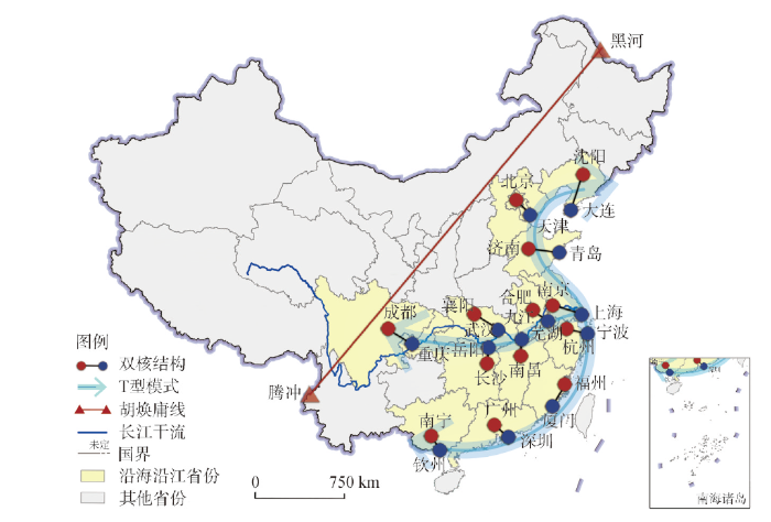
胡焕庸线、“T”型模式和双核结构虽然提出的时代背景不同,但都是对于中国空间格局的总体把握与规律性认知,因此将其进行综合集成表达,至少可以从人文地理学的角度揭示出中国空间格局的总体态势与基本规律(图1)。图1
 新窗口打开|下载原图ZIP|生成PPT
图1中国“一线两轴双核”结构
注:基于自然资源部标准地图服务网站GS(2020)4632号的标准地图制作,底图边界无修改。
Fig. 1The "one-line, two-axis and dual-nuclei" structure in China
从图1中可以看出,胡焕庸线划分了中国的东部和西部,认为东部是中国的人口、城市、经济等的核心区;“T”型模式在此基础上界定了东部地区的发展潜力和开发重心位于沿海和沿江轴线;双核结构则进一步标明,其中起着龙头作用和引领作用的是由区域中心城市和港口门户城市构成的双核轴线,这样分段深入、分层递进,逐步揭示出了中国空间格局的宏观态势、空间差异的内在规律,以及人口、产业和城市的空间集聚特征。再从核心边缘结构理论角度考察,胡焕庸线将中国划分为东西两部分,相当于认知为东部地区为核心区,西部地区为边缘区;在东部地区中,“T”型模式进一步认定沿海和沿江地区为核心区,其他地区为边缘区;在“T”型模式中,双核结构理论更进一步认定由省会城市与港口城市构成的双核及其沿线为核心区,其他为边缘区。这样,由宏观至微观、由国家级至省级分层确定了中国的核心边缘结构,理清了中国区域发展的宏观空间格局。
总之,胡焕庸线、“T”型模式和双核结构是揭示中国空间格局规律性的3个理论,将其进行集成分析可以大致勾绘出中国空间格局的总体态势。更为重要的是3个理论合在一起清晰地展现出了基于人文地理视角对于中国区域差异以及空间格局的认知结论。这与自然地理视角的地域分异规律认识论与方法论,呈现出完全不一样的图景,从而为以人文地理学视角为主导进行区域分析提供了重要的方法论启示。
3 中国空间格局的形成机理与分析视角
从形成机理看,胡焕庸线基于自然地理基础又迭加了一定的人文地理效应;“T”型模式从形态上看属于水轴类型,有一定的自然地理基础,但更重要的形成原因则源于近代以来全球化导致的海运时代到来的影响,因为当代全球贸易联系85%左右依靠海运;双核结构的形成则是区域发展过程中内生力量与外源力量共同作用的结果。其中自然地理的影响已较为薄弱,更主要受制于所在区域对外开放程度与范围的影响,由此与一个国家或地区的社会经济发展状况的关联程度更为紧密。因此,从胡焕庸线经“T”型模式至双核结构,事实上反映了本土人文地理学家从更关注自然地理要素到更为重视人文地理要素对于空间格局影响的转变。3.1 胡焕庸线的自然地理基础与人文地理效应
3.1.1 胡焕庸线的自然地理基础 胡焕庸线的形成主要是基于中国的自然本底基础,其与中国的400 mm等降水量线基本吻合,而400 mm等降水量线蕴含着众多的其他自然地理意义,是中国东部季风区和西北内陆区的分界线,从而构成中国东部湿润地区和西部干旱地区的分界线,具体是半湿润区和半干旱地区的分界线,在此基础上又构成中国森林类原始植被与草原的分界线。另外,地形因素也是影响胡焕庸线的重要因素。总体上,在中国三大地形阶梯背景上,胡焕庸线属于第二与第三阶梯的交界线上,只不过到了长江流域,由于上游成都平原的存在导致该线向西跃至第一与第二阶梯的交界线上。也正是如此,该线以东,平原、河流众多,以西则以高原大漠为主等。3.1.2 胡焕庸线的人文地理效应 胡焕庸线两侧相异的自然本底进一步产生出完全不同的人文景观。基于天然森林植被产生的是农耕定居生产方式,基于草原大漠产生的是草原游牧生产生活方式,基于此的文明也分别称之为农耕文明和游牧文明,于是在此基础上进一步形成各种类型的早期部落和后期的民族,从而奠定了中国丰富多样的民族文化版图。一方面,不同的生产生活方式承载完全不同的人口密度;另一方面,胡焕庸线沿线也成为各种生产生活方式交融、融合的地带,费孝通则称之为“藏彝走廊”“内部边疆”等[23,24,25]。进入当代,随着工业化、城市化的推进,尤其是全球化的推进更使得东部沿海地区的区位优势更加突出,使得胡焕庸线两侧的景观进一步发生了差异性的变化。无论是交通网络,还是工业集聚区以及城市群,都主要集中于中国东部地区。实际上,东部地区完全成为支撑中国经济发展的核心区,而此线以西地区的主要功能则是维系国家安全的生态和军事等的屏障区,构成了典型的核心边缘结构[26,27,28,29,30,31,32,33,34,35,36,37,38,39]。
3.2 “T”型模式的本质是水轴
在基于点轴系统理论提出“T”型开发模式后,国内学术界还相继提出了“∏”型、半“非”型、“弗”型、方格型等各种各样的开发理论和模式,其中尤以“∏”型模式的影响最为突出。1990年编制的《全国国土总体规划纲要》最终采纳的事实上是“∏”型模式:“2000年前后,中国生产力布局以沿海、沿长江、沿黄河为主轴线,结合陇海、京广、浙赣—湘黔、太焦—焦枝、哈大、南昆铁路沿线等二级轴线,构成中国国土开发和建设总体布局的基本框架。”对此,陆大道坚持认为应当是“T”型而不是“∏”型或其他开发模式。事实上,陆大道的观点是对的。仔细分析可以发现,“T”型模式中沿海轴线和沿江构成有其共同点,均与水有关,都属于“水轴”。3.2.1 沿江轴线的发展优势 海运的优势自不必说,自近代以来全球就进入了海运为主的贸易新时代,全球贸易的85%左右均通过海运,由此大幅度提升了沿海港口的区位优势,推进了沿海地带的经济隆升。基本上都不例外,几乎所有国家的发达地区都位居沿海,因此中国沿海纵轴是没有争议的。长江经济带包括9省2市,总面积约205万km2,人口总量和国内生产总值均超过全国的40%。具有以下特点:① 居中区位优势。长江开发轴线位居中国中部,是中国北方和南方的过渡地带。区位特点决定了该地带的发展,具有对于全国最为强烈和有效的带动作用。从农业发展角度看,正是因为地理位置居中,长江经济带以亚热带气候资源为主,使得该地带成为中国唯一的小麦和水稻均适宜大面积种植的地区;② 上游综合开发优势。一般而言,流域内平原的主要分布区为其中下游,上游一般为山地丘陵为主体的地区,如珠江流域即是如此。但长江上游却存在着面积如此之大的成都平原。这在全球范围内的大江大河中可谓绝无仅有;③ 综合性交通运输走廊优势。已形成铁路、公路、航空、水运四位一体的综合运输走廊,交通便捷,水运是其突出优势。2018年长江干线完成货运量26.9亿t,占同期全国内河水运货运量(37.43亿t)的71.82%,占全国铁路货运量(40.26亿t)的66.82%。此外,集装箱吞吐量也达到1750万标箱。由于内河水运成本只有铁路成本的1/4~1/5左右,所以长江水运具有特别突出的运输成本优势;④ 中国最大的横向人口带、城市带。优越的自然条件和适宜的农业生产条件,使得长江流域成为中国人口分布的密集区,人口总量约占全国40%左右。进入近代以后,更成为中国工业化、城镇化的主要地区之一,构成中国最大的横向城市带。在中国五大城市群中,已经基本成形的有位于沿海轴的长三角、珠三角、京津冀城市群,即将成形的有位于长江中游的武汉城市群和长江上游的成渝城市群。
显然,如果沿海轴线和沿江轴线仅是作为点轴系统理论结合中国实际分析的产物,那么,“T”型开发模式不能称为(个例式)理论。但“T”型开发模式本身存在内在规律性,这就是这两条轴线具有共通点:都是水轴。长江开发轴线与中国其他横向开发轴线的最大不同,就在于该轴线属于“水轴”(沿海开发轴线同样属于“水轴”),具有丰沛的淡水资源优势以及巨大的航运价值[40]。
3.2.2 水轴结构的稳定性 特别需要指出,以水轴为基础形成的“T”型开发模式有其稳定性。在中国所有一级、二级轴线中,沿海作为一级轴线没有争议,陇海—兰新线是否应该与沿江轴线一起成为一级轴线,则争议甚多。仅从GDP而论,2018年陇海—兰新线和沿江轴线(仅计滨江城市)分别占全国的比重为5.94%和17.43%,两者完全不成比例。但在“一带一路”倡议的背景下,由于陇海—兰新线是丝绸之路经济带的重要组成部分,显然将在中国未来对外开放格局中提升其战略地位。长江经济带似乎偏离了“一带一路”倡议的实施范围,但实际情况并非如此。一方面,当代的丝绸之路经济带并不会像古代那样以西安为单一起点或终点,而是可以进一步向东延伸。而西安以东已进入中国网络化的路网地区,对长江开发轴而言,境内所有的中心城市都可以成为丝绸之路经济带的东延节点。另一方面,长江开发轴还将以云南昆明为起点,通过与东南亚基础设施的互联互通,从而进入中南半岛和印度洋。实际上,与20世纪90年代仅仅东向通过上海对外开放不同,未来长江开发轴的发展,将进一步拓展西向开放路径,形成东、西同时开放的新格局。
总之,“T”型开发模式是由点轴系统理论这一基础理论指导结合中国实际提炼出的个例式理论。如果与胡焕庸线对应,那么,“T”型模式中的沿海轴线和沿江两个轴线也可称为“陆大道轴”。胡焕庸线揭示的是中国最为宏观的区域差异,陆大道轴则揭示的是中国恒定的基础性、主导性发展轴线。这事实上也说明,地理学家揭示出的空间规律性能够承受得住时间的检验,表明的是不随时间摆动的空间分布上的规律性和稳定性。
3.3 双核结构是区域发展过程中内生性与外源性力量共同作用的结果
归纳双核结构现象的共同点可以发现,一方是政治、经济、文化三位一体的区域性中心城市,以省会城市为主;另一方则是重要的港口城市,行使着区域中心城市的门户港城的功能。那么,在一个区域中,港口城市与区域中心城市为什么能构成相对固定的空间组合,又是如何走向空间耦合的?通过对众多案例的双核结构进行归纳分析,可以发现双核结构的形成与演化导源于区域演化的两种基本的类型,一种是内生型,即双核结构的形成,源起于中心城市率先形成,发育到一定程度后随着对外交往的需要,门户城市逐步兴起,从而导致双核结构的产生、发展与成型。中国双核结构的形成,基本上走的都是一条由内向外、先有核心城市再有门户城市之路,即主要是内生型发展之路。另一种是外源型,即在区域发展过程中门户城市率先发育并成长,后随着对内陆腹地开发的需要,再导致区域中心城市的发育与成长,从而最终形成双核结构。一方面,港口城市由于可以充分发挥水运的低成本优势而往往成为中转枢纽,并可以在此发展相应的临水型产业;另一方面,港口城市的发展同样依赖于区域中心城市的支撑。换言之,从形成机理看,区域双核结构模式所揭示的是某个区域中两个不同功能的城市之间的空间藕合关系。具体而言,在同一个区域中,港口城市与区域中心城市之所以能形成一种固定的空间结构,就在于这种空间组合可以实现区位上和功能上的互补。那么互补的依据是什么?原因在于中心城市要对所在区域充分发挥作用,在其他因素相同下,其对区位的最基本要求是趋中性,即应当尽可能位于所在区域的几何中心。新近出现的区域形态研究,之所以认为团聚状形态优于长条状形态,主要出于中心城市的趋中性的考虑。然而,与区外交往的需要,则拉动中心城市的区位向区域边界方向推移,以至有不少区域中心城市位于区域边界上。显然,这虽然利于与区外的交往,但并不利于对所在区域的带动。而双核结构则兼顾了上述两个方面的需要。因此,双核结构实现了区域中心城市的趋中性与港口城市的边缘性的有机结合[41,42,43,44,45,46]。
4 空间格局理论的类型辨析与内在逻辑
胡焕庸线、“T”型模式和双核结构不仅从不同角度揭示了中国空间格局的基本规律,更重要的是代表了3种不同类型的区域分析的方法论以及人文地理学理论类型,对其作进一步的分析显然有重要的理论与方法论意义。4.1 地理学理论的个例性与普遍性
4.1.1 个例式理论是地理学中的特殊理论 地理学以地球表层为研究对象,侧重于地球表层空间分异规律的挖掘,其中自然地理学上的地域分异规律最为典型。虽然地域分异规律的分析方法是通用的,但地域分异规律的结论在地球上则是唯一的,这就是地理学的个例式理论。胡焕庸线可看作是从人文地理要素角度对中国地域分异规律的揭示,它不仅仅限于人口地理意义,而具有更为综合的人文地理意义,包括农业、民族、文化等多个角度。但它又有空间上的唯一性特点,因为中国有胡焕庸线,其他国家和地区未必能有胡焕庸线。事实上通过初步分析可知,其他国家和地区基本上不存在形成胡焕庸线的条件和基础,因此可以说胡焕庸线在地球上是独一无二的。
特别需要指出的是,胡焕庸线揭示了中国地域分异的内在规律,完全可以称之为一个理论。因此为了纪念胡焕庸先生,将这条线命名为“胡焕庸分界线”。2009年中国地理学会“中国地理百年大发现”评选中,将“胡焕庸线”定为20世纪中国地理最重要发现之一;2017年和2020年黑龙江黑河和云南腾冲县分别建成中国人口地理分界线主题公园。对于胡焕庸线以及胡焕庸先生本人而言,所有这些都是实至名归。
4.1.2 双核结构现象的普适性与理论构建 如果双核结构仅仅是中国存在的一种空间结构现象,那么就还是属于一种个例性理论。但双核结构现象除中国外还广泛存在于其他国家和地区中。如构成美国经济地理横轴的芝加哥—纽约、欧洲的杜伊斯堡—鹿特丹、俄罗斯的莫斯科—圣彼得堡、法国的巴黎—勒阿勿尔与里昂—马赛、巴西的巴西里亚—里约热内卢、阿根廷的布宜诺斯艾利斯—科尔多瓦等。其中,与中国规模相似的美国除国家层面的经济地理横轴外,在省州一级也存在着大量的双核结构现象。双核结构现象分布的广泛性,表明了该理论的普遍适用性。
一些国家尤其是前殖民地国家,历史上由于多种原因而导致首都分布于沿海地带。显然,这虽有利于加强与其他国家的经济联系,却不利于对国内其他地区尤其是广大内陆地区的带动,区域中心的效能未能得到充分发挥。为此,有不少国家进行了首都迁移,从而从根本上改变了所在国家的区域经济发展格局。这样,原来的首都行使港口城市职能,新首都则充分利用政治、经济、文化三位一体的综合作用而发挥着区域中心城市的职能,从而构成一种特殊的双核结构。
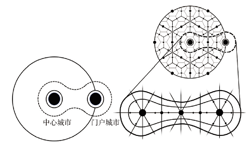
双核结构之所以广泛存在,原因在于区域发展始终是内外两种力量共同作用的结果,这与一个国家采用何种制度无关,也与一个国家采用内生型还是外源型的发展路径无关。而区域中心城市和门户城市则由于对于区域发展的带动能力和对外交往的效果不同,从而对于区域发展的推动作用也不相同,因此,就有可能产生双核结构广泛存在的现象。因此,可以把区域中心城市与门户结构的简单组合视作是双核结构的简易理想图式,而将中心地学说、都市连绵带理论与双核结构简易图式融于一体,形成双核结构的标准理想图式(图2)[47,48,49,50,51,52,53,54,55]。
图2
 新窗口打开|下载原图ZIP|生成PPT
图2双核结构理论的简易图式和理想图式
Fig. 2Simple and ideal schemas of the dual-nuclei structure theory
4.2 区域分析的过程、阶段及其规律性
4.2.1 区域差异、均质区域与胡焕庸线 地理学的研究对象既然是区域,那么研究的第一步就是进行(特定)区域分析,包括区域个性的提炼与区域差异的挖掘,在此基础上进行演化过程与形成机理的分析。然而,区域差异如何表征?这就是均质区域的分析思路。事实上地域分异规律的提炼就是以均质区域为基本前提。胡焕庸线的提出是基于中国人口分布差异现象,以及在此基础上的人口分布规律的分析而提出,其背景是民国时期国内一些地理****将欧美区划论思想、理论与方法引入中国。于是当时还同时产生了秦岭—淮河线的划分,以及中国早期的各类自然区划等研究成果。概而言之,胡焕庸线的提出是基于均质区域假设和地理区划思想而提出,但其闪光点是通过一条直线而体现,从而达到了高度简洁且极为震撼的表达效果。
4.2.2 空间格局、功能区域与“T”型模式 虽然地理学的空间学派始于古典区位论,但功能区域的概念在第二次世界大战以后才由美国****提出。如果说均质区域可以通过数量指标来确定,那么功能区域更强调区内点、线、面要素之间的功能联系,并最终整合为一个整体。显然,如果基于均质区域的分析视角,由沿海和沿江的“T”型轴线无论如何也识别不出来。
将胡焕庸线与“T”型模式比较,可以发现胡焕庸线的理论基础是地理区划理论。显然,前者在基础理论方面并没有明显创新,但“T”型模式则有着陆大道先生在吸收了西方尤其是德国先进区位论基础上原创性提出的点轴系统理论,不仅基于功能区域的研究视角并且结合中国实际而提出。从这一角度考虑,“T”型模式现象的发现较之胡焕庸线的提出,无疑在基础理论的推进上以及中国空间格局的识别上,又前进了一大步。
4.2.3 特殊理论、重复检验与一般理论 双核结构基于“T”型模式之上,因此仅就对中国空间格局的认知而言,其意义和价值不如“T”型模式。然而,双核结构后继的研究已远远超越了对于中国空间格局的现象发现与规律认知,而是沿着两个层面展开:一是在实证层面上进行了全球尺度的大量双核结构的实证分析;二是在理论层面上完成了现象发现、机理分析、数学推导、实践应用的全过程科学研究。
据此,双核结构就与胡焕庸线、“T”型模式完全不同,后两者仅是针对中国空间格局的规律认知,识别的是特殊性空间规律,提炼的是个例式理论,双核结构则升格为一个可重复检验的完整的地理学理论。与基于德国南部的中心地理论、基于美国东海岸的都市连绵带理论等一样,双核结构理论是一个以中国沿海和沿江地区为原型、但完成了由特殊到一般转换、通用性和普适性较强的区域空间结构理论。
上述分析事实上梳理出了有关中国区域差异、空间格局认知的三大理论的逻辑关系,即基于区域差异现象和规律分析而提炼出的胡焕庸线,基于空间格局机理分析而提炼出的“T”型模式,以及在此基础上双核结构现象的发现并进一步构建通用性的地理学理论,基本上相当于区域分析、规律凝炼和理论提炼的三大阶段,由此构成了以中国为实证区域、相对连续的规律凝炼和理论提炼谱系,从而可为人文地理学理论的提炼提供研究思路和方法论角度的重要启示。
5 结论与讨论
胡焕庸线、“T”型模式与双核结构3个理论均提出于20世纪。进入21世纪以来,国内外发展态势发生了重大变化。中国在不断地融入全球经济体系的同时,工业化、城市化水平也有了明显提升,2019年中国城市化水平已超过60%,进入了都市圈、城市群时代。那么,3个理论在新时期的适应性如何?在当前中国正在构建双循环新发展格局的背景下,这些问题有待做进一步的深化研究。5.1 胡焕庸线和“T”型模式体现出高度的稳定性
虽然表面上胡焕庸线是一条人口线,但背后却有400 mm等降水量线支撑,从而构成中国东部湿润地区和西部干旱地区的分界线,以及中国森林类原始植被与草原的分界线,在此基础上又成为农耕文明和游牧文明的分界线。有这样综合的自然地理和人文地理要素为基础,不仅过去近百年来两侧人口比例的变化不大,即使展望未来,胡焕庸线将依然是中国最为重要的东西分界线。因此,所谓胡焕庸线的突破,纯粹是一个伪命题。基于点、线、网络的分析思路以及单核、双核、多核的分析方法,一些****认为中国未来的发展图景应该是多轴线、网络式空间格局,但无论如何,由沿海轴线和沿江轴线构成的“T”型模式,依然是其中最为重要的也是等级最高的2条。其中,沿海轴线的重要性自不必说,东西横向上,珠江轴线难说成形,陇海—兰新线的体量与长江轴线完全不成比例。因此,展望未来,沿海轴线和沿江轴线,将一直是中国最为重要的开发轴线。这就是客观规律和基础理论的稳定性特征。
5.2 双核结构表现出稳定性与动态性的统一
与胡焕庸线和“T”型模式比较,双核结构则不仅具有一定的稳定性特征,同时还具有明显的动态性特征,体现出稳定性与动态性的统一。(1)从规模结构看,中国沿海和沿江地区双核结构中,沈阳—大连、北京—天津、济南—青岛、杭州—宁波、成都—重庆在所在区域体现出稳定性特点,双核结构现象比较明显。而另外一些双核结构,如合肥—芜湖、南昌—九江、长沙—岳阳、南宁—钦州等,则要么双核结构特征不太明显,要么处于动态变化之中。
(2)从影响因素看,双核结构的形成与演化与所在区域的对外开放度有关。显然,对外开放度较高的情形下,港口门户城市的优势就比较突出;对外开放度下降的情形下,港口门户城市的优越度就明显下降。近年来,强省会战略的实施,省会城市地位的相对上升对原来的双核结构产生重大的影响。例如,安徽省原来实施的是由合肥和芜湖双核驱动的发展战略,但近年来却在大力推动强省会战略。特别需要指出,中国正在实施的以内循环为主导的“双循环”战略,将更加强调内需市场的作用。这对中国双核结构会产生何种影响,显然值得做进一步的深入研究。
(3)从空间形态看,由于中国总体上进入了都市圈和城市群的时代,中国空间格局的演化将深受中心城市的驱动和带动,因此,双核结构的组织结构和空间形态也将可能发生重大的变化。例如,广西在“十三五”时提出双核驱动发展战略,即通过以南宁为核心的桂中城市群和以北海为核心的北部湾城市群作为双核,共同带动广西的区域发展。在这里,“核”的概念已不限于单一的城市,而是都市圈和城市群的概念;又如,湖南未来的空间结构,可能是长株潭城市群与岳阳组合的“城市群+城市”式的双核结构,等等。因此,未来中国沿海和沿江地区的双核结构,完全有可能演化为都市圈(城市群)与都市圈(城市群)构成的新的双“核”的空间组织形态。这显然需要进行专门的分析探讨。
致谢
该文研究思路得到清华大学顾朝林教授启发;点轴理论和“T”型开发模式的相关资料由中国科学院地理科学与资源研究所陈明星研究员提供,特此致谢!参考文献 原文顺序
文献年度倒序
文中引用次数倒序
被引期刊影响因子
[本文引用: 1]
[本文引用: 1]
[本文引用: 1]
[本文引用: 1]
[本文引用: 1]
DOI:10.11821/xb193502002 [本文引用: 1]

China is the most populous country of the world.Besides her great numberof population she has also the most densely inhabited regions which are notcomparable with any other country of the world.
[本文引用: 1]
[本文引用: 1]
[本文引用: 1]
PMID:12284413 [本文引用: 1]
PMID:12284413 [本文引用: 1]
[本文引用: 1]
[本文引用: 1]
[本文引用: 1]
[本文引用: 1]
DOI:10.11821/xb200102001 [本文引用: 1]
This paper is a further analysis of the “Pole Axis Theory” and related “T shaped” spatial structure of the industrial allocation in China, which was developed by the author a decade ago. It starts with an analysis of the relationship between different types of spatial structure and regional development, and of how to achieve optimal regional development through optimal spatial organization as well. Then, based upon existing theories and practices in China, it discusses the formation of the “pole & axis” system by disclosing the evolution of socio economic organization and demonstrates that such a system is the most efficient spatial structure that can lead to optimal regional/national development. Lastly, the paper concludes that the strategy of a “T shaped” spatial structure of industrial allocation, which is an application of the “Pole Axis Theory”, has played a very important role in the spatial economic development in China in the last decade.
[本文引用: 1]
[本文引用: 1]
[本文引用: 1]
[本文引用: 1]
[本文引用: 1]
[本文引用: 1]
[本文引用: 1]
[本文引用: 1]
[本文引用: 1]
[本文引用: 1]
[本文引用: 1]
DOI:10.11821/xb198702001 [本文引用: 1]
In China there exists enormous regional differences in territorial exploitation and economic development. We have two regional developing macrostratogies to chose from: stressed (focal point) exploitation and balanced development. On the basis of Chinese and foriegn practices and theories of regional development, the author points out, China should adopt the strategy of stressed exploitation. That is, Chinese regional economic development ought to follow the model of sequenced diffusion in the way of point-axis to realize relative balance. In order to strengthen the ties between the Eastern and Western China and put the strategy into practice. We must set up prior industrial zones throughout the country. This is possible especiully along the coast and the Chang Jiang (yangtze) River, both of which are first class axises and there by can form an economic macro-pattern in the shape of a "T". Besides, the economic zones should widely establish their horitontal relations among themselves as well.
[本文引用: 1]
[本文引用: 1]
[本文引用: 1]
[本文引用: 1]
[本文引用: 1]
DOI:10.11821/xb199906003 [本文引用: 1]
The paper condensed the m ajor viewpoints of 1997 RegionalDevelopm ent Re- port ofChina. The report took the regionaleconom ic developm ent as the m ajor them e, sum m arized m ainly the regionalpoliciesatnationaland provinciallevelsduring theeighth- five-yearplan and early stageoftheninth-five-yearplan, analyzed and evaluated thepolicy effects, developm entstates, existing problem s, and put forw ard som e recom m endations for regionaldevelopm entpolicies. Based on thesystem aticdiscussions, thepaperdrew the conclusions as follows: 1) The m acro-strategy to develop the coastalregions as priority exactly m atched our country’s situations atpresentstage, and the policies to im prove the Middle and WestChina developm enthad positive effectsto reverse the trends ofenlarged differencesbetw een the Eastand WestChina; 2) To realize the overallstrategictargetsof “Three-stage-theory”stillrequired theenforcem entofcoastalm odernization pulling strat- egy, and the infrastructure and socialdevelopm entshould be the priorities in the Middle and WestChina developm ent; 3) The pole ofregionaldevelopm entshiftsouthwards, the econom ic grow th in theSouth wasm oreactive, thestructuralissuesin theNorth hinderedthe socialand econom icdevelopm ent. During the processes ofreducing the regionaldiffer- encesbetween the Eastand the West, the difference ofeconom ic activities and structures between the North and the South should also be taken into considerations; 4) The abso- lute differences ofeconom ic developm entlevels enlarged rapidly am ong allprovinces, au- tonom y regionsand m unicipalities. How ever, therelative differencesshow ed thetrendsof declining; 5) There were w idely progressatprovinciallevelsin industrialstructuralalter- nations and new econom ic growth pole innovations, the provincialdevelopm entcharacter- ized with uniquefeatures,thedifferencesoftransportation, com m unication, infrastructure becam e m ore obvious, the allocation of grain production bases shifted northw ards and westw ards, and the problem s eagerto success and ofduplicate construction w ere very se- vere in grain production aspects; 6) The out-wards econom ic developm enthavegreatcon- tributions to sustainable and rapid econom icgrowth since reform and opennessbegan, but the effectsoffavorite policies in specialregionsand coastalopen cities declined gradually, thecontinued absorption offoreign fundsdepended gradually on econom icdevelopm entac- tivities of particular regions. Our country’s out-ward econom ic developm ent should en- force the regionalcore rolesofspecialregionsand coastalopen cities w hich were m ore ac- tive in econom ic developm ent; 7)The changes ofpoverty alleviation strategies have taken place from quantity to quality. The differences ofpoverty alleviation effectsam ong differ- entregionswereobvious, so did the facing problem s; 8)Thetaxation reform m etthe sub- jectneedsto controlthe regionalresourcesin m arketeconom y, and itincreased the finan- cialcapacity ofcentralgovernm ent, butthedream to im prove theregionalcoordinated de- velopm ent did not com e true. The distribution ofcentralgovernm ent financialaids were unfair between the less developed and m ore developed regions, and the correlation was very w eak between the financialaids percapita and GDPper capita ofeach province, au- tonom y region orm unicipality; 9)Thescopeofregionaleconom iccooperation enlarged and the form s diversified. The cooperation betw een the East and the West had obvious progress, but the cross-regions econom ic and technicalcooperation w as facing financial and banking barriers; 10)High developm entgrowth rate resulted in m ore and m oresevere ecologicalproblem swith therelatively seriousw aterand airpollution and very severe eco- logicaldegradations.
[本文引用: 1]
[本文引用: 1]
[本文引用: 1]
[本文引用: 1]
[本文引用: 1]
[本文引用: 1]
[本文引用: 1]
[本文引用: 1]
[本文引用: 1]
[本文引用: 1]
[本文引用: 1]
[本文引用: 1]
[本文引用: 1]
[本文引用: 1]
[本文引用: 1]
[本文引用: 1]
[本文引用: 1]
[本文引用: 1]
[本文引用: 1]
[本文引用: 1]
[本文引用: 1]
[本文引用: 1]
[本文引用: 1]
DOI:10.11821/dlxb201701012 [本文引用: 1]
Hu Line uncovers one of China's most important characteristics of population paper distribution: East is dense, while west is sparse. Different from most previous research, this paper examined the differentiation and changes of population distribution on both sides of Hu Line from a perspective of spatial stratified heterogeneity instead. Geodetector was employed based on the spatial database of China's census data of 1953, 1982, 1990, 2000 and 2010 to reconfirm spatial position of Hu Line and analyzed changes of spatial stratified heterogeneity of population between southeast and northwest sides of Hu Line in different periods. Changes of population distribution since the founding of New China were found and the reasons for these changes were discussed. Major findings include: (1) From the spatial stratified heterogeneity perspective, Hu Line could be improved and optimized, at least, in some periods. Although the ratio of total population on both sides of Hu Line has roughly been kept at 94:6 since 1953, spatial stratified heterogeneity of population between the two sides (the southeastern side: the northwestern side) increased when Hu Line moves to south slightly in 1953, 2000 and 2010, which means population distribution was more homogeneous within either southeastern or northwestern region and heterogeneity was more remarkable between the two regions. (2) Heterogeneity decreased gradually since the reform and opening up. We found characteristics of population distribution converged on the two sides, especially since the 1990s when convergence between the two sides became apparent. This finding is significantly different from the conclusion of "remain unchanged" from most literatures. The reasons why heterogeneity reduced were: pattern of population distribution on the southeastern side changed from relatively even distribution among cities before 1990 to agglomeration in a few huge cities after 2000, while the degree of spatial agglomeration of population decreased slightly after the reform on the northwestern side. These changes have been confirmed by the analysis from cumulative distribution function and Gini coefficient. (3) On the whole, the effect of economic factors on population distribution has become more and more important, while the effect of natural environment and institution reduced. Combined effect from economic development, natural environment and institution resulted in two opposite directions of changes of population spatial distribution on the two sides. It should be emphasized that although general effect of natural environment has decreased, some natural factors, such as Three Gradient Terrains, still have significantly influence on population distribution in China.
[本文引用: 1]
[本文引用: 1]
[本文引用: 1]
DOI:10.1007/s11442-016-1346-4URL [本文引用: 1]
DOI:10.1007/s11442-016-1347-3URL [本文引用: 1]
DOI:10.11821/dlyj201605001 [本文引用: 1]
Hu Huanyong, a famous geographer, discovered a divide of population geography in China in 1935 (hereinafter referred to as the Hu Line), which was an important achievement in the development of the discipline of geography in China, and was widely accredited and cited. In November, 2014, Premier Li Keqiang raised a question about the Hu Line, when he visited the exhibition of sciences of human settlements in the National Museum of China. This question is whether the Hu Line can be broken or not again caused a stir. Hereby we invited some geographers to have academic discussion on this question, aiming to demonstrate their understanding and reflection on the Hu Line from different perspectives. Thus, the scientific value and practical significance of the Hu Line are deepened, and furthermore, the Hu Line can provide reference for the implementation and regional planning of the new-type urbanization in China.
[本文引用: 1]
DOI:10.11821/dlxb201602001 [本文引用: 1]
In November, 2014, Premier Li Keqiang raised a problem about Hu Huanyong population line (hereinafter referred to as "Hu line"), when visiting the exhibition of sciences of human settlements in National Museum of China, which was called "Premier's Question" by the press. Hence, Hu line has become a highlight currently, and aroused great controversy and different views. Aiming at such dilemma of cognition, this paper gives a general review of the origins of Hu line, which was put forward by the famous population geographer Hu Huanyong in 1935, under the background of a debate on the surplus of domestic population. Based on population census data and GIS platform, the paper analyzes the change of population scale, proportion and density in both southeast and northwest sides of Hu line. The results indicate that the population urbanization and migration do not change the pattern of population distribution determined by Hu line. On such basis, the pattern that the population density of southeast part is large, while that of northwest part is relatively small will not radically change over a longer period, and the pattern that urban agglomeration is mainly located in southeast part as well. The long-term existence of Hu line depends on integrated physical geographical conditions, like climate. At the meantime, this paper argues that the core issue of the Premier's concern is solvable, by positive policy guidance and reasonable spatial organization. It is definitely promising for western China to realize a higher level of modernization and a better quality of urbanization, and central region as well.
[本文引用: 1]
[本文引用: 1]
[本文引用: 1]
[本文引用: 1]
[本文引用: 1]
DOI:10.11821/dlxb201504004 [本文引用: 1]
The Hu Line for population distribution in China has been regarded as one of the greatest geographical discoveries in China because it reveals the significant spatial characteristics of China's human-land relationship. Thus, the stability and significance for spatial development of Hu Line have become a major concern after the dramatic economic and social changes since China's reform and opening-up in 1978. With the support of GIS, this paper conducts a statistical analysis and systematic investigation on the stability and spatial patterns of population growth on both sides of Hu Line by constructing the spatial database of China's census data from 1982 to 2010 and initiating a new method for identifying the spatial patterns of population growth. The findings are as follows: (1) The Hu Line has been rather stable, while a new tendency of population change has emerged. On the whole, the ratio of population on both sides of Hu Line has roughly been kept at 94:6 (the southeastern side: the northwestern side) in the last 30 years. However, the proportion of population on the southeastern side of Hu Line has been slightly decreasing, while that on the northwestern side of Hu Line has been slightly increasing, which is benefited from its higher rate of natural population growth. (2) The spatial patterns of population growth on both sides of Hu Line were quite different. The agglomeration degree of population distribution on the southeastern side of Hu Line increased greater. The areas with negative population growth rate have rapidly expanded, mainly located south of the Qinling Mountains - Huaihe River line and the northeastern China, while the areas with the fast population growth rate concentrated in the areas such as the Yangtze River Delta, the Pearl River Delta and Beijing-Tianjin metropolitan region. Thus, the spatial pattern of population growth on the southeastern side of Hu Line presented an aggregating and diffusion mode of Matthew effect. (3) The spatial pattern of population growth on the northwestern side of Hu Line could be referred as the relative balance type. In this region, the positive rate of population growth and the lower agglomeration degree of population have been identified. There were lots of ethnic groups located on the northwestern side of Hu Line, and they generally lived dispersedly but with a higher rate of natural population growth due to preferential population policy. However, there were also some areas with negative rate of population growth on the northwestern side of Hu Line and they were mainly distributed close to the Hu Line and new Eurasia Land Bridge. (4) In the future, the spatial patterns of population growth on both sides of Hu Line will continue to change. On the southeastern side of Hu Line, the capacity of population agglomeration for those small and medium-sized cities and towns should be enhanced. As for the northwestern side of Hu Line, the emphasis should be placed on promoting its urbanization and enhancing the capacity of population agglomeration for major cities.
[本文引用: 1]
[本文引用: 1]
[本文引用: 1]
[本文引用: 1]
[本文引用: 1]
[本文引用: 1]
[本文引用: 1]
[本文引用: 1]
[本文引用: 1]
[本文引用: 1]
[本文引用: 1]
[本文引用: 1]
[本文引用: 1]
[本文引用: 1]
[本文引用: 1]
[本文引用: 1]
[本文引用: 1]
[本文引用: 1]
[本文引用: 1]
[本文引用: 1]
[本文引用: 1]
[本文引用: 1]
[本文引用: 1]
[本文引用: 1]
[本文引用: 1]
[本文引用: 1]
[本文引用: 1]
[本文引用: 1]
[本文引用: 1]
[本文引用: 1]
[本文引用: 1]
[本文引用: 1]
[本文引用: 1]
[本文引用: 1]
[本文引用: 1]
