 ,1,2, 刘昌明2, 郝秀平,3, 邱冰1, 王中根2
Theoretical basis and priority areas of the interconnected river system network research
LI Zongli,1,2, LIU Changming2, HAO Xiuping,3, QIU Bing1, WANG Zhonggen2通讯作者:
收稿日期:2019-06-26修回日期:2020-12-28网络出版日期:2021-03-25
| 基金资助: |
Received:2019-06-26Revised:2020-12-28Online:2021-03-25
| Fund supported: |
作者简介 About authors
李宗礼(1964-), 男, 甘肃武威人, 博士, 教授级高工, 主要从事水文水资源、水利规划与水战略研究。E-mail:

摘要
关键词:
Abstract
Keywords:
PDF (1203KB)元数据多维度评价相关文章导出EndNote|Ris|Bibtex收藏本文
本文引用格式
李宗礼, 刘昌明, 郝秀平, 邱冰, 王中根. 河湖水系连通理论基础与优先领域. 地理学报[J], 2021, 76(3): 513-524 doi:10.11821/dlxb202103002
LI Zongli, LIU Changming, HAO Xiuping, QIU Bing, WANG Zhonggen.
1 引言
河湖水系连通战略作为中国江河治理和水资源开发利用保护的新理念,已经被确立为国家重大治水战略[1],不仅得到了学术界的广泛关注,也在实践领域得到积极响应,国内许多省、市、自治区纷纷开始推进各具特色的河湖水系连通战略与工程[2]。蓬勃发展的河湖水系连通实践迫切需要理论的指导和支撑。河湖水系连通的理论研究必须以可持续发展为战略目标,运用现代水文水资源学、经济学、社会学、生态学、环境学、地理学、系统工程、信息学等相关学科理论知识,构建促进水资源、经济社会和生态环境协同演进的河湖水系连通理论框架,研究河湖连通水循环变化与过程、流域安全保障与风险控制、流域系统整体调配等相关的理论基础,为河湖水系连通实践提供科学依据。基于河湖水系连通概念框架、分类体系等方面的研究[2,3,4,5]以及实践案例的分析,本文梳理可以支撑河湖水系连通的相关科学理论,以期推动河湖水系连通理论研究的深入和进步,并逐步形成河湖水系连通的理论体系;根据当前国家河湖水系连通实施中迫切需要解决的问题,展望河湖水系连通理论研究的优先领域。
2 河湖水系连通的理论基础与体系框架
随着人类社会的发展,现代社会的河湖水系已发展为由自然过程形成的江河、湖泊、湿地等水体以及人工修建的水库、闸坝、泵站、渠道等水工程共同组成的复杂的“自然—人工”复合的河湖水系。河湖水系连通是以提高水资源统筹调配能力、改善河湖生态环境、增强抵御水旱灾害能力,实现水资源可持续利用为目标,通过疏导、沟通、引排、调度等措施,建立和改善河流、湖泊、湿地等水体之间的水力联系,优化调整河湖水系格局,形成引排顺畅、蓄泄得当、丰枯调剂、多源互补、可调可控的江河湖库水网体系[2,3,4,5,6,7,8]。河湖水系连通具有丰富的内涵,既是传统水利的丰富与发展,也是适应治水新要求和变化环境的水利发展新理念[9,10,11,12]。河湖水系连通战略实施亟需丰富和系统的理论体系做支撑。与传统水利相比,河湖水系连通的理论研究具有显著的复杂性、系统性和多学科交叉的特征。
(1)复杂性。人类文明的发展与进步对河湖治理与开发保护提出了需求变化、功能增加、尺度增大、风险加大、泛流域化等新挑战,河湖水系连通将多个复杂系统组合为新的巨系统,导致巨系统的复杂性呈指数级增长,特别是经济问题、社会问题、生态问题与水问题叠加后更加难以定量表达与模拟,将是未来河湖水系连通研究的重大难题。
(2)系统性。河湖水系连通将形成一个多目标、多功能、多层次、多要素的泛流域复杂水网巨系统。其理论研究必须以系统科学理论为基础和方法论,以河湖水系系统和经济社会系统、生态与环境系统交互融合的复杂大系统为研究对象,综合研究泛流域复杂巨系统的内部要素与结构组成、系统层次与相互关联、系统动态与外部环境之间的相互关系,揭示河湖水系格局与经济社会、生态环境格局相互的作用关系,探求巨系统协调发展的机制与途径。
(3)多学科交叉。河湖水系连通基于水循环机理,着重研究不同尺度下的河湖水系连通的复杂特性,以及河湖水系与生态环境、经济社会之间的作用机制,其理论基础涉及可持续发展理论、水循环理论、水资源配置理论、生态系统健康理论等多学科内容以及系统论、控制论、协同论、自组织理论和风险管理理论等多种系统科学方法论[13,14,15,16],这些学科的理论是河湖水系连通理论体系研究的有力支撑和有益借鉴。
相关学科与河湖水系连通理论研究的关系及河湖水系连通理论体系框架如图1。
图1
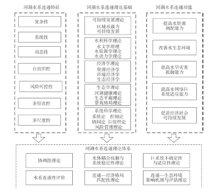 新窗口打开|下载原图ZIP|生成PPT
图1河湖水系连通理论体系研究框架
Fig. 1The research framework of the theory system on IRSN
2.1 可持续发展理论
可持续发展理论是河湖水系连通研究和实践的目标引领,也是河湖水系连通理论研究的重要基础。2.1.1 可持续发展 可持续发展是不断提高人群生活质量和环境承载能力的、满足当代人需求又不损害子孙后代满足其需求能力的、满足一个地区或国家需求又未损害别的地区或国家人群满足其需求能力的发展。水资源的可持续利用是经济社会可持续发展的重要基础,是可持续发展思想在水资源开发利用中的具体应用。
河湖水系连通利用合理的人工调控措施恢复或新建河湖水系之间的水力联系,旨在提高流域/区域水资源统筹调配能力、修复和改善水生态环境、降低水旱灾害风险、保障水安全,最终实现水资源的可持续利用,支撑经济社会的可持续发展,促进生态文明建设。因此,实现可持续发展是河湖水系连通的根本宗旨和目标,其理论应贯穿并指导于河湖水系连通规划、实施、运行和管理等各个环节。
2.1.2 区域承载力 区域承载力理论将资源环境作为统一体,研究其同人类及人类经济社会活动相互匹配与适应的关系。区域承载力作为衡量区域可持续发展的重要标志之一,可定量揭示区域发展中存在的主要问题和发展方向。许多地区的水资源、水环境和水生态问题已经成为区域产业布局和经济发展的重要制约因素,其承载能力关系到区域经济未来发展的前景[17,18]。
河湖水系连通必须统筹考虑流域/区域发展需求、安全需求、生态需求和文化需求,通过建设合理的引调水工程,实施科学的调度管理,提高水资源调控能力,实现丰枯调剂、多源互补,改善水资源和社会经济发展布局、生态文明建设进程的匹配程度,从而提高区域水资源、水环境、水生态的承载能力,最终实现水资源的可持续利用与经济社会可持续发展。因此,区域水资源承载力理论是河湖水系连通研究的重要指导理论。
2.2 水利科学理论
水利科学是治水事业最根本的知识体系,是河湖水系连通的基础性理论,是河湖水系连通研究、实践的重要支撑和依据,是河湖水系连通理论体系的重要基础。水利科学体系庞大、内容甚多,此处只选择关系最紧密的水文、水资源、水动力学简要分析。2.2.1 水文学原理 河湖水系是地球水循环的产物,水循环理论是河湖水系连通的核心基础理论。目前,自然水循环过程已受到人类活动的严重影响,水循环理论研究内容也扩展至耦合自然现象和人类活动的“自然—社会”二元水循环。
河湖水系连通将从水循环路径和特征2个方面显著改变区域水循环过程,并对经济社会和生态环境产生重要影响。河湖水系连通的研究需从“自然—人工”复合系统的水循环机理出发,探讨自然演变、人类活动对河湖水系格局和状况变化的贡献,研究基于河湖水系连通的水循环要素之间的相互作用机制,建立基于河湖水系连通的分布式水循环模拟模型,模拟河湖水系连通后相关区域降水、地表水、土壤水和地下水的转化规律,揭示连通对水循环的影响,进而从河湖水系连通所带来的重大变化、产生的重大影响等方面研究河湖水系连通伴生的水循环变化机制和过程,揭示河湖水系连通对不同区域/流域水资源统筹调配、河湖健康、洪水风险控制、经济社会格局、生态环境功能的影响机制、后果与演变趋势。
2.2.2 水资源学理论 水资源学是对水资源进行评价、合理配置、综合开发、合理利用和保护,为经济社会的可持续发展提供水源保障,处理好水资源和社会经济发展及环境、生态系统间关系,以及对水资源实行科学管理和保护经验的系统总结所形成的知识体系,是河湖水系连通的指导性理论基础。
提高国家层面水资源宏观调配能力,需要在保护生态环境的前提下,通过科学论证兴建长距离大规模跨流域引调水工程,必须深入开展连通区域之间的水资源供需平衡分析、丰枯遭遇分析,模拟连通之后调水区、调入区水量变化伴生的水质、水生态、水环境的改变及其对经济社会和生态环境的影响,开发超大尺度泛流域水资源优化配置模型与方法、水量调度模型与方法;这些都需要在水资源学理论的支撑之下不断探索、发展。
2.2.3 水动力学理论 河流生命在于水的流动,维系河流生命的核心是水循环,健康的河湖水体首先要有维系其流动的动力条件。水动力学理论是研究水及其它液体的运动规律及其与边界相互作用形成的知识体系,是研究河湖水体流动规律及边界条件的基础理论学科。
人类社会发展过程中,由于城市扩张、围湖造田、侵占河道滩涂等活动,削弱了河道与两岸、湖泊湿地的连通性,扰乱甚至阻断了水系的水力联系,使洪涝水蓄泄空间和排洪通道受阻,河道泄洪能力减弱,防洪安全受到威胁;也有一些水系由于水流通道受阻,水循环动力不足,水环境承载能力降低,引发水体富营养化乃至形成黑臭水体。河湖水系连通旨在通过合理的人工措施,恢复和增强河湖水系的连通性,改善河湖水体水动力条件,增加河道泄洪能力,维护河湖健康。水动力学理论为河湖水系连通增加水体联系,改善水体流动性,构建河湖水系连通水动力学模型提供不可或缺的理论基础。
2.3 经济学理论
经济学理论是为河湖水系连通提供经济学理念和方法,经济学理论是河湖水系连通的重要技术和方法理论支撑,也是河湖水系连通理论体系的重要基础理论。2.3.1 资源经济学与水资源优化配置 自然资源的稀缺性和天然分布的空间差异性,以及其与社会经济需求的不匹配等特点,决定了资源优化配置的重要性。基于资源经济学的水资源优化配置理论,通过投入产出分析,从流域/区域经济结构和发展规模分析入手,将水资源优化配置纳入宏观经济系统,促进流域/区域经济和资源利用的协调发展。
河湖水系连通是解决水资源时空分布不均问题、缓解产业布局和水资源匹配矛盾、提高水资源统筹调配能力的有效措施。资源经济学为河湖水系连通的实施和管理提供了经济学基础,将经济学理论融入河湖水系连通的理论研究,丰富水资源优化配置理论,发展基于河湖水系连通的水资源优化配置理论,构建以水资源系统、社会经济系统、生态系统相互制约模型为基础、以维系生态系统良性循环为控制约束、以支撑最大社会经济规模为优化目标的河湖水系优化配置模型,制定科学的河湖水系优化配置方案,在更大尺度上实现水资源在流域/区域之间、部门之间、产业之间的优化配置,促进国家、流域/区域等不同层面水资源的可持续利用和经济社会的可持续发展。
2.3.2 环境经济学与水环境管理 环境经济学是指运用经济科学和环境科学的原理和方法,分析经济发展和环境保护的矛盾,以及经济再生产、人口再生产和自然再生产三者之间的关系,选择经济、合理的物质变换方式,以使用最小的劳动消耗为人类创造清洁、舒适、优美的生活和工作环境。宏观层面,环境经济学提出了将环境问题考虑在内的新的国民经济核算体系;微观层面,环境经济学根据环境问题的外部性特点,提出环境污染控制的最优水平应该是社会纯收益最大化时的污染水平。
以河湖水系连通提升河湖生态环境质量,除采用必要的工程手段改善河湖水体水力联系,提高河湖水体的纳污能力和自净能力,还必须充分考虑产生水环境问题的经济原因和利益驱动,考虑经济发展与河湖环境改善之间的博弈关系。河湖水系连通理论研究应充分融合环境经济学理论,基于水权、排污权界定和管理,采用边际分析法、均衡分析法、影子价格、机会成本等方法合理衡量水环境的经济价值,通过税收、财政、信贷等经济杠杆,调节经济活动与环境保护之间的关系、污染者与受污染者之间的关系,促使生产和消费活动符合保护环境和维护生态平衡的要求,以技术先进、经济合理的河湖水系连通战略,达到水污染有效治理、水环境大力改善的目标。
2.3.3 生态经济学与河湖生态保护 生物多样性和生态系统服务是人类社会生存和发展的基础,生态经济学是以生态经济复合系统的结构及其矛盾运动发展规律为研究对象,从经济学和生态学的结合上,围绕着人类经济活动与自然生态之间相互作用的关系,研究生态经济结构、功能、规律、平衡、生产力、效益以及宏观管理和数学模型等内容,寻求人类经济发展和自然生态发展相互适应、保持平衡的对策和途径。
河湖水系连通以改善河湖生态功能、保障河湖健康为其三大功能之一,是人类寻求自然生态健康与经济社会协同发展的战略举措。生态经济学理论及其研究结果可为科学合理实施河湖水系连通工程及措施,解决环境资源问题提供科学依据。河湖水系连通理论研究也应基于生态经济学基本理论和研究成果,根据流域/区域水生态问题的成因,分析人类活动干扰河湖生态系统的经济学驱动机制,从更高层次、更大尺度上提出保护、改善河湖生态的科学对策和模式,全面提高河湖健康保障能力。
2.4 生态学理论
生态学理论为河湖水系连通修复、改善河湖生态系统提供重要的理论指导和技术方法,是河湖水系连通理论体系重要的理论基础。2.4.1 河湖健康理论 河湖健康理论是伴随着生态系统健康概念形成的,以维护河湖良好的生态状况和可持续的社会服务功能为目标,主要从河湖健康评价、河湖生态系统的保护以及河湖健康的维持和恢复等方面对河湖生态系统的现状及存在的问题进行诊断评价,对河湖生态修复的进程进行监测,为河湖健康的适应性管理提供反馈信息,为河湖管理提供目标和方向,进而促进流域实现水资源的综合管理和流域生态系统良性循环。
河湖水系连通改变了水体之间的水力联系,同时也必然影响水体生态系统,影响河湖的结构和功能。发展基于河湖水系连通的河湖健康理论,充分吸收河湖健康理论中生态基流、生态水位、河湖健康指标体系等知识点和知识体系,创立基于河湖水系连通水网络的泛流域河湖健康评价模型、方法,从而在更大尺度上维系河湖水体的流动性和连续性,提高水体自净能力和纳污能力,充分发挥水生态系统自我修复能力,同时发挥湿地、湖泊水体的综合功能,实现河流健康与河流水体可持续开发利用。
2.4.2 生态平衡理论 生态平衡是一种动态的平衡、相对的平衡。生态系统对外界的干扰和压力具有一定的弹性,外界干扰或压力在一定范围之内,生态系统通过自我调节能力而恢复;如果超出所能承受的极限,生态系统就会衰退,甚至崩溃。生态平衡理论是河湖水系连通维持河湖生态健康的重要理论基础。
河湖水系连通通过合理的、适当的人工调控措施进行水资源统筹调配,改善水动力条件,打破原有生态平衡状况,促成新的生态平衡。在维护生态平衡的基础上,满足河湖水体生物生存的生态需水量和水体自净能力的基流量,充分发挥河湖水系连通的功能,维护良好的水体生态环境,改善河湖生态系统结构,实现更高效的生态功能和效益。
2.4.3 景观生态学理论 景观生态学以整个景观为研究对象,运用生态系统原理和系统方法研究景观结构和功能、景观动态变化以及相互作用机理,强调景观的美化格局、优化结构、合理利用和保护[19]。水域景观生态学作为生态学与水利科学的交叉学科和生长点,为河湖水系连通的理论研究提供了新的研究视角。水域景观生态学定量地描述水域景观中结构与功能的关系,比如异质性、等级性、方向性或不同空间尺度上的过程反馈,其中涉及到一些主要理论有河流连续体理论、洪水脉动理论、水域廊道理论等[20]。同时,城市化进程的迅猛发展和城市人居环境要求的提高,使城市水域景观价值不断提升,城市水景观、城市水生态廊道等概念应运而生,滨水景观格局的规划和设计成为城市景观建设的重要部分[21]。
基于水域景观生态学,河湖水系连通工程应高度重视景观格局安全和优化,统筹考虑流域/区域水域景观生态结构和功能,充分发挥水景观和流域内河湖水系之间的相互作用,以河湖水系连通促进景观结构的优化[22],维护生物多样性,提高生态稳定性,美化人居环境;此外河湖水系连通工程必须符合生态化、景观化的要求,尊重水的自然规律,使城市水景观的建设规模和用水与当地的水资源、水环境承载能力相适应。
2.5 系统科学理论
系统科学理论是以系统为研究对象,研究各类系统的关系和属性,揭示其活动规律,探讨有关系统的各种理论和方法。系统科学理论为河湖水系连通研究和实践提供有力的方法论支撑,是河湖水系连通理论体系的基础方法理论。2.5.1 系统论:复杂巨系统理论 河湖水系连通是在“自然—人工”复合水系的基础上,统筹考虑社会经济与生态环境因素,融入技术与控制、管理体系等因子构建的复杂水网络系统。因此,系统理论是河湖水系连通研究的基本理论,系统论是最根本的方法论。经济社会、生态环境、河湖水系等作为系统的有机组成部分,通过水资源的配置、利用、消耗,在结构和功能上相互交织、相互影响、相互作用,推动着复杂巨系统不断运动、发展。河湖水系连通的研究、规划和管理必须从系统的角度出发,综合考虑不同区域、不同流域、不同部门、不同行业之间的利益关系,以整体提高水资源统筹调配能力、河湖生态环境健康保障能力和水旱灾害抵御能力为目标,使系统内各有机组成部分竞争、共生、再生和自生原理得到充分的体现,最终实现水资源的高效利用、人水高度和谐和经济社会的可持续发展。
2.5.2 协同论:协同发展理论 河湖水系连通必须合理协调和平衡河湖水系生态功能与社会服务功能之间的关系,促进区域间河湖水系、经济社会、生态环境格局相互适应和协同发展是河湖水系连通战略实施的主要目标。基于协同学理论,河湖水系连通应通过对经济、社会和生态环境子系统中的序参量进行调节、控制,提高其协同作用,实现水资源系统的有序演化。实质是协调不同区域间河湖水系、经济社会和生态环境子系统的关系,保持不同区域及系统之间的动态平衡,使河湖水系连通复合水网络系统达到一种整体、综合和内性发展的组合,呈现出水资源高效利用、社会用水结构合理、经济健康发展、生态环境良好的稳定状态。协同学理论运用自组织、序参量、竞争以及协同等概念和原理[23],可通过协调开放复杂系统中各子系统的协同行动来促使系统有序演化,为简化水资源配置等复杂问题的计算维数、协调多目标利益冲突提供了一个普适的理论研究框架[23,24]。
2.5.3 自组织理论:水系自然演进规律 河湖水系是水循环的产物,既有自组织现象,又存在自组织作用。其自组织作用主要发生在系统内部,如自然水循环系统在地表水资源开采后通过地表水与地下水的转换进行自我调整,维系其再生能力;河湖水体受污染后的自净过程,也是河湖水体自组织现象。河湖水系连通作为人类干预自然水系的一种措施,需在尊重河湖水系、生态环境自组织演变规律的基础上,积极引导和发展自组织作用向有利方向演变。如河湖水系连通要为河流生态修复和保护创造条件,加强物质、能量与信息的输入,维系河流自组织过程,激励河流生态系统内部各因素的非线性相互作用,通过循环耦合,维系生态系统自组织过程,从而保护河流生态廊道、生物多样性和水生态系统的健康稳定。
2.5.4 控制论:反馈与调整 由区域“水资源—社会经济—生态环境”复合系统的总体特性可知,区域水资源优化配置是一个动态发展的过程,且这种动态的变化与经济发展的动态变化紧密相连。在水资源的优化配置研究中,只有充分考虑这种动态过程才能保证优化配置方案的科学与可行。因此,河湖水系连通研究和规划需建立在经济社会、生态环境动态变化和发展的基础上,研究各系统之间的反馈与调整机制,以最优控制理论、大系统理论、动态规划和微分对策等理论为基础,寻求系统最优控制规律,建立一套相应的预警机制和预控方案,从而保障社会经济和水资源的可持续利用实现长期协同发展。
2.5.5 风险管理理论 风险是人类历史上长期存在的客观现象,河湖水系连通形成的泛流域复杂水网络巨系统包涵要素多、涉及范围广。河湖水系连通工程连接多个存在一定社会经济水平差异的水资源分区,其运行管理涉及到自然、社会、经济及生态系统的方方面面。众多不确定因素的存在不可避免的会对工程的运行造成影响,给项目的实施效果带来风险,如工程风险、水文风险、生态与环境风险、经济风险和社会风险等,直接影响河湖水系连通功能正常运行。
风险管理理论为河湖水系连通风险管理提供了重要的理论基础[25]。基于风险管理理论,河湖水系连通应分区域、分类型研究评估潜在风险,制定风险控制措施,提出应对风险的策略,以降低河湖水系连通可能造成的不利影响,达到工程的预期目标。
3 河湖水系连通理论研究优先领域
目前,河湖水系连通的基本原理、内在机制、过程规律的系统认知还没有形成,部分地区实践环节存在认识不清、系统性不强、协调性不足、碎片化严重、盲目上马开工等问题,急需加大研究和创新力度,借鉴相关学科理论,确定优先部署领域,加快构建并逐步完善河湖水系连通理论体系。根据前述河湖水系连通理论体系框架,初步提出河湖水系连通理论研究的优先领域。(1)河湖水系连通性与功能评价理论与方法。水系完整性是维系河湖自然功能的基础,但却是一个长期以来受到忽视的领域;对水系完整性研究不足、认识不深,是水系遭受人类活动影响而受损的主要原因,也是水利部聚焦“盛水的盆”和“盆中的水”的重要出发点。科学的连通应是在维系水系完整性前提下的泛流域化,是基于水系完整性基础之上的适应经济社会发展等多功能需求的连通。首先应建立水系完整性(结构完整性、功能完整性)评价体系,在此基础上发展水系连通性与功能评价理论与方法;其连通性和功能评价应在河流地貌学、景观生态学和图论等领域相关研究的基础上,借鉴生态学、经济学等相关理论,研究提出综合反映河湖水系结构连通、功能连通和社会连通等多方面连通性的概念与指标,深入分析河湖水系连通的自然功能和社会功能,构建量化连通功效的准则、指标体系和评价模型等,逐步形成完整的河湖水系连通性与功能评价理论与方法。
(2)河湖水系连通水体耦合机制与系统稳定性理论。河湖水系连通不是不同水体之间简单的疏、堵、连、断,而是本就非常复杂的多个系统的功能组合和提升;特别是不同流域、河流与湖泊、流域与城市、城市外江与内河水体之间的连通,涉及到水量交换、泥沙输移、污染物质与营养物质的转移扩散、水生生境改变、水旱灾害风险转移等许多复杂且敏感的问题,必须慎重论证。应在复杂系统理论、水文学、水动力学等领域相关研究的基础上,借鉴生态水文学、社会水文学相关原理、方法和模型,重点研究河湖水系连通各水体之间耦合作用机理、河湖水系连通自然因素与人工措施的耦合与作用机制、基于河湖水系连通的“水量—水质—水生态”耦合系统演变机制、“河湖水系—经济社会—生态环境”复杂巨系统稳定性及稳态控制原理等,形成河湖水系连通水体耦合机制与系统稳定性理论,结合已有相关研究成果[26,27]丰富和完善河湖健康评价理论与方法,为河湖水系连通的规划、河湖水系连通的水循环宏观调控和管理奠定科学基础。
(3)河湖水系连通协调性理论。人类社会的发展和进步不断对河湖治理与开发保护提出新要求和新目标,特别是生态文明建设、美丽中国建设战略更是要求统筹协调安全、经济、美丽、舒适等多部门利益关系和多功能冲突需求。应在系统科学理论、生态学、经济学等领域相关研究的基础上,关注生态文明、美丽中国等国家重大战略研究进展,研究河湖水系连通巨系统生态功能与社会服务功能之间的协调关系、河湖水系连通与区域经济社会发展的协调关系、河湖水系连通与生态系统健康稳定的协调关系,逐步形成河湖水系连通协调性理论,促进河湖水系连通复杂水网络巨系统协调稳定发展。
(4)水系连通—经济格局匹配性理论。必须正确处理水系连通与经济社会发展之间的相关关系。融合系统科学、经济学等相关理论,重点借鉴国内外区域经济布局、城市群发展、高质量发展与资源承载力的最新研究成果,关注京津冀、长三角、粤港澳大湾区、长江经济带与长江大保护等国家重大战略需求,研究河湖水系与经济社会发展之间的相互作用、水系格局与经济发展格局之间的匹配关系,重点突破匹配关系的关键表征指标、量化分析模型和方法,逐步形成并发展完善水系连通—经济格局匹配性理论,为改善河湖水系—经济格局匹配程度,提高水资源宏观调配能力,保障重要经济区和城市群、能源和粮食生产基地等区域供水安全提供理论基础。
(5)水系连通—生态环境影响机理与评估理论。必须正确处理水系连通与生态环境保护之间的相关关系。融合系统科学、生态学等相关理论,重点借鉴国内外水文连通性、河湖治理活动与水系变化等方面的重要研究成果[28,29,30,31],研究河湖水系与生态环境之间的互依互馈关系、河湖水系连通与生态环境相互作用机理,重点突破河湖水系连通关键生态环境指标及其量化分析模型、方法,加快构建重点河湖生态环境用水及过程保障理论与方法体系,创新发展基于水体流动性的城市河湖水系水环境承载力改善提升理论与方法,逐步形成水系连通—生态环境影响机理与评估理论,为保障河湖健康、维系生物多样性、建设生态文明提供理论支撑。
(6)巨系统不确定性与适应性理论。以水文学、水动力学理论及气象学、风险管理等相关理论为基础,以河湖水系连通巨系统为对象,关注并借鉴气候变化应对、极端水文事件应对等方面的国内外重要研究成果[32,33,34,35,36],重点研究气候变化对河湖水系连通复杂水网络巨系统的影响、变化环境下河湖水系连通系统不确定性机理,创新发展复杂水网络巨系统不确定性与适应性理论,重点提出河湖水系连通系统应对大尺度极端水文事件、重大灾害事件、突发公共安全事件的模型、方法和对策,创新推进大尺度河湖水系连通“目标—代价”风险方法与模型,为加快构建基于大数据、物联网、超算等新技术的河湖水系连通复杂水网络巨系统风险调控体系及平台提供理论支撑,促进河湖水系连通管理政策的模拟与制定能力不断提升。
4 结语
科学实施河湖水系连通必须有科学理论的指导,但目前河湖水系连通理论比较零散,尚未形成系统的理论体系,理论研究已经落后于实践的需求;借鉴相关学科理论,为河湖水系连通提供理论支持非常必要和紧迫。综合考虑河湖水系连通特征和目标,以及已有相关学科理论与河湖水系连通理论研究的关联性,认为可持续发展、水利科学、经济学、生态学、系统科学等相关学科可为河湖水系连通提供理论基础,河湖水系连通理论研究必须在广泛吸纳相关科学理论的基础上,关注相关领域最新研究进展并合理借鉴其研究成果,不断凝练、创新独有理论,逐步形成河湖水系连通的理论体系。从当前国家河湖水系连通实施中迫切需要解决的问题出发,构建河湖水系连通理论体系,应在借鉴相关学科理论基础上,优先在河湖水系连通性与功能评价理论与方法、水体耦合机制与系统稳定性理论、水系连通协调性理论、水系连通—经济格局匹配性理论、水系连通—生态环境影响机理与评估理论、巨系统不确定性与适应性理论等方面优先开展研究工作。参考文献 原文顺序
文献年度倒序
文中引用次数倒序
被引期刊影响因子
URL [本文引用: 1]
[本文引用: 1]
DOI:10.11849/zrzyxb.2011.03.018URL [本文引用: 3]

The remarkable growth in China’s population and economy over the past several decades has come to realize at a tremendous cost to the country’s environment, particularly around water. China’s water resources are over-allocated, inefficiently used, and grossly polluted by domestic and industrial wastes, to the point that vast stretches of rivers are dead and dying, lakes are cesspools of waste, groundwater aquifers are over-pumped and unsustainably consumed, and direct adverse impacts on both human and ecosystem health are widespread and growing. For addressing these crippling water problems, a new strategy of Interconnected River System Network (IRSN) is put forward, which is of great necessity for improving the capacity of water resources allocation, sustaining river’s heath and enhancing flood and drought control. However, up to now both the theory and technology of IRSN have still been a blank, far from the practices. Based on the further requirement of national water security and the improvement of the ecological civilization, with the new idea of human-water harmony and water resources livelihood, this paper presents a concept of IRSN, which can be defined as a river system network formed by constructing the hydraulic connection of water bodies of rivers, lakes and wetlands with various kinds of water projects, characterized by proper diversion and drainage,reasonable storage and discharge, adjustment of low and high runoff, complementary water multisource, controllable capacity, and the river system network appears to be complex, systematic, dynamic, temporal and spatial. Then the general thoughts of IRSN is proposed on the basis of the river system connection goal, the study of the IRSN can be carried out at four steps: 1) mechanism analysis, the theoretical basis of the whole study; 2) system identification and assessment, the analysis of the current status of IRSN in the researched region/basin, and the construction of Safety Evaluation Model with the complete indicators; 3) IRSN project plan, the make-out of the programmers with the requirement and problems of the society, and choosing the optimal decision from the solutions set; and 4) river system optimization and adjustment, the river system network will be reevaluated with the information of the monitoring system, and adjusted according to the principle of realizing the goal of sustainable development. According to the general thought of IRSN, some key problems worth specially concerning in the study are discussed, including different scales of IRSN, the process of river network connection, the pattern matching, the function of IRSN and the control methods.
[本文引用: 3]
DOI:10.11849/zrzyxb.2011.11.016URL [本文引用: 2]
Presently, operating Interconnected River System Network (IRSN) is the new policy and strategy for guiding various water activities and ensuring the water safety in China. Generally speaking, the IRSN is a multi-factor, multi-scale and multi-function system with the prominent feature of extreme complexity and hugeness. While scientific classification of IRSN practices is the foremost and required issue, which aims at providing reliable basis for the researches and practices of IRSN activities. In the present paper, according to the property and essence of the IRSN, we first proposed five criteria for the classification of IRSN, namely scientificalness, systematicness, dominance, direction and maneuverability. Then, by considering the natural, economic and social properties of the IRSN practices, and also followed the above five criteria we comprehensively analyzed various factors concerning the IRSN, including the contention properties, contention functions, contention regions, contention scales, contention objectives, contention duration, contention pattern, and contention direction, and further established an IRSN classification system. Furthermore, based on the IRSN classification system established, we summed up and classed a large number of typical ISRN practices in China. Finally, we selected the connection property-based, connection function-based, and regional water resources character-based classification types, and discussed the contention characteristics, contention objective as well as several other main problems of the three classification types, respectively. The results gained from this paper can provide helpful guide for the researches and policy making about the IRSN activities in China in the future.
[本文引用: 2]
DOI:10.11849/zrzyxb.2011.03.019URL [本文引用: 2]
Climate change and human activities affected water supply and water management, and brought a lot of water issues, such as drought, flood, water shortage, deterioration of water environment, etc. In order to fundamentally increase water resources allocation ability, improve ecological environment quality, and enhance the capacity to withstand flood and drought disasters, in China, a new national strategic plan on the constructing river system network was put forward. We have called this plan as IRSN (Interconnected River System Network) plan. To grasp the strategic thinking of IRSN, this paper, based on the basic concept of river, lake, and water system, discussed the hydrological characteristics of rivers and lakes, and analyzed the role of rivers and lakes in the river system network, and pointed out that the river is the main component and lake is the "connector ", "converter" and "storage device" of constructing river system network, and reservoir can be seen as an artificial lake. How to keep the river water mobility and continuity and play the role of lake water storage capacity and ecological benefits as wetland, are the keys to IRSN plan. This paper presents four basic water cycle issues that should be concerned in the implementation process of IRSN plan. First is about water balance. As the structure and characteristics of the natural water system were changed by engineering measures (such as water diversion project, construction of dams, reservoirs, etc. ), the original water balance must be broken. We need to re-examine the new relationship of water balance of the changed river water system. Second is energy balance. The connection of rivers and lakes should be done according to the conversion law of water, the potential energy and kinetic energy, and as far as possible using water bodies own energy to maintain water mobility. Third is about water resources renewability. Just improve river mobility to enhance water resources renewability in river water network. This is the most basic goal of IRSN plan. Fourth is about water cycle scale. As for different water cycle scales, the water connectivity rules are different. So, IRSN plan has the characteristics of multi-temporal and multi-spatial scales.As IRSN plan is an important new plan on water management in China, the related theoretical researches have lagged behind the practices. The purpose of this study is to promote the establishment of theoretical system on IRSN plan. The results of this paper will lay the theoretical basis of hydrology for implementation of the IRSN strategic plan.
[本文引用: 2]
URL [本文引用: 2]
The issue of sustainable water resources has been receiving much attention for years. With the development of economy and society in China, increasing requirements on water resources will necessitate a strategic shift. Being the new strategy of China, the Interconnected River System Network (IRSN) plan will play a significant role in water resources management in the future. To that end, it is urgent to prompt the research on the theoretical and technology system. Nowadays, studies on IRSN are more loosely scattered and have not been developed into a systemic and scientific theory system. Within IRSN, three major functions will be realized, i.e., increasing water resources allocation, improving river health, and enhancing flood and drought control. IRSN is a pan-regional concept, with different scales showing different characteristics. In terms of reality of water resources exploitation and protection in China, the authors stated in the paper that the research on IRSN can be essentially divided into three levels, i.e., national, regional, and basin levels. Differences are highlighted at each scale, i.e., 1) at the national scale, it primarily focuses on regional differences and how to make sustainable use of water resources, and coordinate the relationships among resources, society, economy and the environment. This will greatly promote the national and regional development; 2) at the regional scale, according to the functional position, comparative advantages, and water system characters of the region, it will contribute to rational water resources allocation, adapting to productive layout, and ultimately realize sustainable development of the region; and 3) at the river basin scale, the principle is the integration of the interest of every user among different reaches, and the development of nature and human within the whole river basin, with the aim to ultimately realize the sustainable water resource use, the environmental health, and sustainable development of economic society at the basin level. In the changing environment, there will be a series of challenges in the research, e.g., 1) how to match best between the distribution of river systems, and the eco-social layout. This is an effective measure of solving water shortages and ensuring stable economic development, and also the key point and great challenge of the IRSN; 2) uncertainty of climate change and the effects on IRSN. In particular, increasing extreme events will impose a big challenge for flood and drought control of the IRSN; and 3) interdisciplinary and comprehensive research. Due to the complexity of the system, the research on the IRSN will involve interdisciplinary theory, which is also a challenge for the researchers.
[本文引用: 2]
DOI:10.11821/dlxb201903012URL [本文引用: 1]
Based on the monthly runoff data of five stations in three outlets of Jingjiang river from 1956 to 2016, hydrologic drought characteristic variables were identified by run length theory. The probability distribution functions of drought duration, drought intensity and peak value were selected by Kolmogorow-Smirnov's goodness test. A Copulas function was constructed to deeply study the river hydrologic drought characteristics after the river connectivity variation in this region. The results showed that: (1) The year 1989 was the break point of the river system connectivity in three outlets of Jingjiang river (1956-2016). (2) The hydrologic drought characteristics changed significantly before and after river system connectivity break point. The frequency, duration, intensity and peak value of hydrologic drought increased. (3) The two-dimensional joint recurrence periods under the same single variable recurrence period in the pre-variation era in each site were much longer than those in the post-variation era but the two-dimensional co-occurrences return periods of pre-variation were shorter than those of post-variation. (4) The hydrologic drought duration, drought intensity and peak value in river system of the three outlets in Jingjiang river showed an increasing trend after river system connectivity variation. Under the same single variable recurrence period, the drought duration was longer, the drought intensity was greater and the peak value was higher. (5) The magnitude of hydrologic drought characteristics was different before and after variation of river system connectivity, and the variation ranges of hydrologic drought characteristics were different in different river systems.
[本文引用: 1]
[本文引用: 1]
[本文引用: 1]
DOI:10.5814/j.issn.1674-764x.2017.03.005URL [本文引用: 1]
Interconnected river system networks is a national water conservancy strategy in China and focus of research. Here we discuss the classification system, material and energy exchange between rivers and lakes, various dynamic flows and ecological functions of river-lake interconnected relationships. We then propose a novel method for the health assessment of river systems based on interconnected water system networks. In a healthy river system there is “material and energy exchange” and it is the first and foremost relationship of material and energy exchange between rivers and lakes. There are unobstructed various “flows” between rivers and lakes including material flows (water, dissolved substances, sediments, organisms and contaminants), energy flows (water levels, flow and flow velocity), information flows (information generated with water flows, organisms and human activities) and value flows (shipping, power generation, drinking and irrigation). Under the influences of nature and human activity, various flows are connected by river-lake interconnection to carry material and energy exchange between rivers and lakes to achieve river-lake interactions. The material and energy exchange between rivers and lakes become one of the approaches and the direct driving forces of changes in river-lake interconnected relationships. The benignant changes in river-lake interconnected relationship tend to be in relatively steady state and in ideal dynamic balance.
DOI:10.11821/dlxb201801010URL [本文引用: 1]
3-N, TN and TP were chosen as the water quality indexes to simulate the flow field and water quality of the Tangxun Lake group under different IRSN schemes. In addition, a comprehensive evaluation system based on evaluation indexes from the aspects of water hydrodynamics, water quality and socioeconomics was established to evaluate the IRSN effects of the Tangxun Lake group. The results showed that the fluidity of lakes improved greatly after the water diversion. The IRSN project can improve water quality of the lakes in a short time, while the improvement rate decreased gradually as the water diversion time increased. The comparison of these five schemes mentioned in this paper indicated that the fifth scheme (concurrent diversion from Donghu Lake and Liangzi Lake) can achieve the most obvious improvement in both hydrodynamics and water quality and generate the most economic benefits.]]>
[本文引用: 1]
DOI:10.11821/dlxb201601006URL [本文引用: 1]
Based on the river system data in the 1960s, 1980s and 2010s, the indicator system of quantitative description of river systems change characteristics was established, then the spatial-temporal changes of river systems and its relationship with urbanization in Jiaxing over the past 50 years was analyzed. Results indicated that: (1) Over the past half century, river systems of Jiaxing showed a decline trend. Specifically, the river development coefficient, river density and water surface ratio decreased by 58.91%, 28.94% and 14.09%, respectively. However, the degradation of the river systems varies in different urbanization stages. (2) In the whole urbanization process, the spatial differences of the changes of the river development coefficient and main river area length ratio were extremely large, and the spatial differences of the changes of the river density and water surface ratio were larger, but the spatial differences of the changes of the box dimension and river sinuosity were relatively small. (3) The decline trend of the river development coefficient, box dimension and river density was more significant in the urban area than that in the suburbs and outer suburbs, the decline trend of the water surface ratio was more significant in the outer suburbs than that in the suburbs and urban area, and the decline trend of the river sinuosity was more significant in the suburbs than that in the urban area and outer suburbs, but the spatial change trend of the main river area length ratio was insignificant. (4) The impacts of urbanization on river systems changes were extremely significant, and the changes of river systems were more drastic in higher urbanization level regions, but the impacts of urbanization on main river area length ratio and river sinuosity were larger than that on river development coefficient and river density.
[本文引用: 1]
[本文引用: 1]
[本文引用: 1]
[本文引用: 1]
[本文引用: 1]
[本文引用: 1]
[本文引用: 1]
[本文引用: 1]
[本文引用: 1]
[本文引用: 1]
[本文引用: 1]
[本文引用: 1]
[本文引用: 1]
[本文引用: 1]
[本文引用: 1]
[本文引用: 1]
[本文引用: 1]
[本文引用: 1]
[本文引用: 1]
[本文引用: 1]
[本文引用: 1]
[本文引用: 1]
[本文引用: 1]
[本文引用: 1]
[本文引用: 1]
[本文引用: 2]
[本文引用: 2]
[本文引用: 1]
[本文引用: 1]
[本文引用: 1]
[本文引用: 1]
[本文引用: 1]
[本文引用: 1]
[本文引用: 1]
[本文引用: 1]
[本文引用: 1]
[本文引用: 1]
[本文引用: 1]
[本文引用: 1]
[本文引用: 1]
[本文引用: 1]
[本文引用: 1]
[本文引用: 1]
[本文引用: 1]
[本文引用: 1]
[本文引用: 1]
[本文引用: 1]
[本文引用: 1]
[本文引用: 1]
[本文引用: 1]
[本文引用: 1]
[本文引用: 1]
[本文引用: 1]
