黄峰,
中国农业大学资源与环境学院/农业部华北耕地保育重点实验室 北京 100193
基金项目: 国家重点研发计划项目2016YFD0300801013
详细信息
作者简介:连勰, 主要从事流域水文-作物建模和水资源配置研究。E-mail:lianxie@cau.edu.cn
通讯作者:黄峰, 主要从事流域生态水文建模与全国/区域生态与粮食安全用水权衡研究。E-mail:fhuang@cau.edu.cn
中图分类号:X37计量
文章访问数:529
HTML全文浏览量:6
PDF下载量:375
被引次数:0
出版历程
收稿日期:2019-01-09
录用日期:2019-03-20
刊出日期:2019-09-01
Green/blue water allocation as affected by Grain-for-Green practices in the upper reaches of the Yiluo River
LIAN Xie,HUANG Feng,
College of Resources and Environmental Sciences, China Agricultural University/Key Laboratory of Arable Land Conservation(North China), Ministry of Agriculture, Beijing 100193, China
Funds: the National Key Research and Development Program of China2016YFD0300801013
More Information
Corresponding author:HUANG Feng, E-mail:fhuang@cau.edu.cn
摘要
HTML全文
图
参考文献
相关文章
施引文献
资源附件
访问统计
摘要
摘要:土地利用变化对区域水循环具有重要影响,土地利用决策就是水资源决策,这一命题已经被诸多研究证实并被研究者和决策者所认识。本文以黄河流域中游的伊洛河上游流域为研究区域,应用分布式流域农业生态水文模型SWAT(Soil and Water Assessment Tool),在我国退耕还林还草的生态恢复和重建的重大背景下,分别设置了6种不同的土地利用变化情景,基于蓝水和绿水的视角,研究土地利用/覆被对流域水循环的影响。本文对SWAT模型输出的月径流结果进行了率定和验证,证明该模型对研究流域水文循环的模拟达到了可接受水平的准确性与合理性。采用单因素方差分析和多重比较,分析基于不同水文年型下土地利用变化对各水文要素变化的影响。结果表明:1)2010-2015年多年平均降水资源总量为34.94亿m3,多年平均蓝水绿水资源总量为34.09亿m3,蓝水资源量占多年蓝水绿水资源总量的33.73%,绿水资源量占多年蓝水绿水资源总量的66.27%。2)不同情景退耕还林或还草,蓝水资源量均减少,绿水流均增加,绿水库均减少。在丰水年和平水年,退耕还林还草对蓝水资源量中地表径流分量影响较明显。该结论对于加深认识伊洛河上游流域土地利用/覆被和水资源的相互关系具有一定意义,为该区域高效合理利用水土资源提供了科学依据。
关键词:蓝水/
绿水/
土地利用/
退耕还林还草/
伊洛河上游流域/
SWAT
Abstract:Land use/cover change (LUCC) is of significant impact on regional water cycle. Land use decision-making is water resources decision-making, which has been confirmed by many studies and recognized by researchers and decision makers. Taking the upper reaches of Yiluo River in the middle reaches of the Yellow River Basin as the case study area, this paper applied the distributed watershed agricultural eco-hydrological model SWAT (Soil and Water Assessment Tool). According to the important background of ecological restoration and reconstruction of Grain-for-Green in China, six different land use change scenarios were set up to study the impact of land use/cover change on watershed water cycle from the perspective of blue/green water. This paper calibrated and validated the monthly runoff output of SWAT model, and proved that the model achieved acceptable accuracy and rationality in simulating the hydrological cycle of the river basin. One-way ANOVA and multiple comparisons were used to analyze the effects of land use change on the changes of various hydrological factors based on different hydrological years. The results showed that:1) From 2010 to 2015, the annual average precipitation resources was 3.494 billion m3, and the annual average of total blue water and green water resources was 3.409 billion m3. Blue water resources accounted for 33.73%, and green water resources accounted for 66.27% of the total blue water and green water resources in multi-year average. 2) Under different scenarios of Grain-for-Green, the amount of blue water resources decreased, the green water flow increased, and the green reservoirs decreased. In the year of the wet year and normal year, the impact of land use/cover change on the surface runoff component of the blue water resources was more obvious. This conclusion has certain significance for deepening the understanding of the relationship between land use/cover and water resources in the upper reaches of the Yiluo River, and provides a scientific basis for efficient and rational utilization of water and soil resources in the region.
Key words:Blue water/
Green water/
Land use/
Grain-for-Green/
Upper-stream basin of Yiluo River/
SWAT
HTML全文
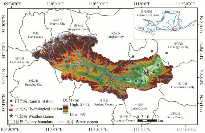
图1伊洛河上游流域地理位置及水文气象测站分布
Figure1.Geographical location and hydrometeorological station distribution in the upper reaches of the Yiluo River
 下载: 全尺寸图片幻灯片
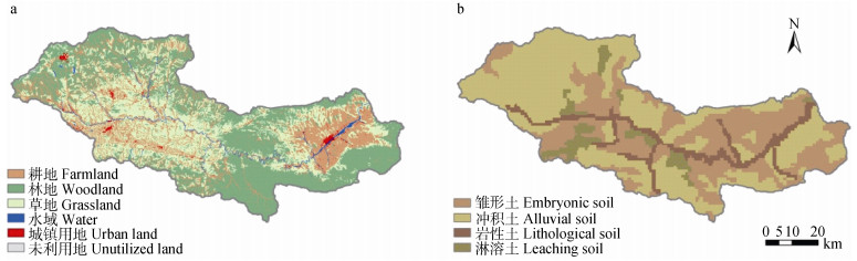
图2伊洛河上游流域土地利用/覆被图(a)和土壤图(b)
Figure2.Land use/coverage map (a) and soil types map (b) of the upper reaches of the Yiluo River
下载: 全尺寸图片幻灯片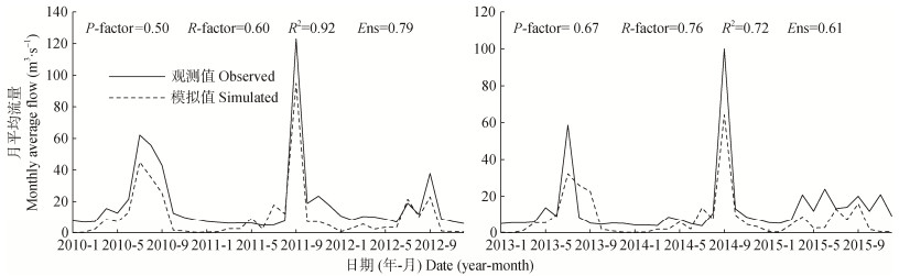
图3伊洛河上游流域灵口水文站率定期(左)和验证期(右)的月平均流量模拟结果
Figure3.Monthly average flows in calibration (left) and validation (right) periods of the Lingkou Hydrological Station in the upper reaches of the Yiluo River
下载: 全尺寸图片幻灯片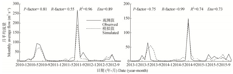
图4伊洛河上游流域卢氏水文站率定期(左)和验证期(右)的月平均流量模拟结果
Figure4.Monthly average flows in calibration (left) and validation (right) periods of the Lushi Hydrological Station in the upper reaches of the Yiluo River
下载: 全尺寸图片幻灯片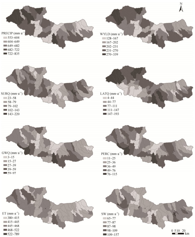
图5伊洛河上游流域多年平均降水量(PRECIP)、产水量(WYLD)、地表径流(SURQ)、壤中流(LATQ)、回归流(GWQ)、渗漏量(PERC)、实际蒸散量(ET)和土壤含水量(SW)
Figure5.Annual average precipitation (PRECIP), water yield (WYLD), surface runoff (SURQ), lateral flow (LATQ), return flow (GWQ), percolation flow (PERC), actual evapotranspiration (ET), and soil water content (SW) in the upper reaches of the Yiluo River
下载: 全尺寸图片幻灯片表1伊洛河上游流域基础数据内容及来源
Table1.Contents and sources of basic data in the upper reaches of the Yiluo River
| 数据类型Type of data | 数据描述Data description | 数据来源Data sources |
| 数字高程模型 Digital elevation model | 分辨率为30 m×30 m The resolution is 30 m × 30 m. | 地理空间数据云 Geospatial Data Cloud |
| 数字水系图 Digital water system | 1:100万数字水系图 1:1 million digital water system diagram | 全国地理信息资源目录服务系统 National Catalogue Service for Geographic Information |
| 土地利用/覆被数据 Land use/coverage data | 2015年土地利用/覆被数据(30 m × 30 m) Land use/coverage data in 2015 (30 m × 30 m) | 中国科学院资源环境科学数据中心 Resource and Environmental Science Data Center of Chinese Academy of Sciences |
| 土壤空间数据 Soil spatial data | 0~30 cm、30~100 cm土壤机械组成(1 km × 1 km) 0-30 cm、30-100 cm soil mechanical composition (1 km × 1 km) | 中国科学院资源环境科学数据中心 Resource and Environmental Science Data Center of Chinese Academy of Sciences |
| 土壤属性数据 Soil attribute data | 利用SPAW软件和EXCEL对土壤组成、容重等进行计算 Calculation of soil composition, bulk density, etc. using SPAW software and EXCEL | 中国科学院资源环境科学数据中心 Resource and Environmental Science Data Center of Chinese Academy of Sciences |
| 气象数据 Meteorological data | 2009—2015年41个雨量站 Fourth-one rain stations from 2009 to 2015 | 黄河流域水文年鉴 Hydrological data of Yellow River Basin |
| 1980—2016年国家卢氏气象站日值气象数据 Daily value weather data of the National Lushi Weather Station from 1980 to 2016 | 中国气象数据网 China Meteorological Data Network | |
| 水文数据 Hydrological data | 2009—2015年灵口和卢氏水文站月平均流量 Monthly average flow of Lingkou and Lushi Hydrological Stations from 2009 to 2015 | 黄河流域水文年鉴 Hydrological data of Yellow River Basin |
下载: 导出CSV表2伊洛河上游流域退耕还林/还草情景设置
Table2.Scenarios of Grain-for-Green in the upper reaches of the Yiluo River
| 情景模拟 Scenario simulation | 描述 Description |
| 情景1 Scenario 1 | 大于25°以上坡耕地进行退耕还林 Sloping farmland above 25° returned to forest |
| 情景2 Scenario 2 | 大于15°以上坡耕地进行退耕还林 Sloping farmland above 15° returned to forest |
| 情景3 Scenario 3 | 全部耕地退耕还林 All farmland returned to forests |
| 情景4 Scenario 4 | 大于25°以上坡耕地退耕还草 Sloping farmland above 25° returned to grassland |
| 情景5 Scenario 5 | 大于15°以上坡耕地退耕还草 Sloping farmland above 15° returned to grassland |
| 情景6 Scenario 6 | 全部耕地退耕还草 All farmland returned to grassland |
下载: 导出CSV表3SWAT模型主要参数取值
Table3.Main parameters of the SWAT model
| 参数名称 Parameter name | 参数含义 Parameter meaning | 初始范围Initial range | 参数调整值 Parameter adjustment value | |
| 最小值 Minimum value | 最大值 Maximum value | |||
| v__SLSUBBSN.hru | 平均坡长Average slope length (m) | 10 | 150 | 13.15 |
| v__SMTMP.bsn | 融雪基温Snow melt base temperature (℃) | -5 | 5 | -1.43 |
| v__CANMX.hru | 最大冠层截留量Maximum canopy storage (mm) | 0 | 100 | 59.75 |
| r__SOL_K.sol | 土壤饱和导水率Soil saturated hydraulic conductivity (mm·h -1) | -0.5 | 0.5 | -0.03 |
| v__ALPHA_BF.gw | 基流alpha因子Base flow alpha factor (d) | 0 | 1.0 | 0.95 |
| v__ESCO.hru | 土壤蒸发补偿系数Soil evaporation compensation factor | 0.01 | 1.0 | 0.18 |
| r__SOL_Z.sol | 土壤表层到底层的深度Depth from soil surface to bottom of layer (mm) | -0.5 | 0.5 | -0.17 |
| v__CH_N2.rte | 主河道河床曼宁系数Mainning’s n value for the main channel | 0 | 0.3 | 0.14 |
| r__SOL_ALB.sol | 湿润土壤反照率Moist soil albedo | -0.5 | 0.5 | 0.12 |
| v__REVAPMN.gw | 浅层含水层“再蒸发”或渗透到深层含水层的阈值深 Threshold depth of water in the shallow aquifer for “revap” or percolation to the deep aquifer to occur (mm) | 0 | 500 | 111.25 |
| v__:参数值被给定值代替或绝对变化; r__:参数值乘以(1+给定值)或相对改变。v__: the parameter value is replaced by given value or absolute change; r__: the parameter value is multiplied by (1 + a given value) or relative change. | ||||
下载: 导出CSV表4伊洛河上游流域逐年水文要素平衡和变化情况
Table4.Balance and change of hydrological elements in the upper reaches of the Yiluo River
| ×108m3 | |||||||||||
| 年份Year | PRECIP | WR | SURQ | LATQ | GWQ | WYLD | PERC | SW | ΔSW | ET | ΔSW* |
| 2010 | 38.63 | 37.77 | 7.26 | 6.16 | 3.09 | 16.51 | 3.95 | 3.29 | -2.51 | 23.77 | -2.51 |
| 2011 | 42.49 | 40.65 | 6.78 | 7.31 | 3.67 | 17.76 | 5.50 | 6.06 | 2.77 | 20.12 | 2.78 |
| 2012 | 26.09 | 26.48 | 2.09 | 3.71 | 0.73 | 6.53 | 0.36 | 3.72 | -2.34 | 22.29 | -2.36 |
| 2013 | 28.56 | 28.17 | 3.44 | 4.12 | 0.17 | 7.73 | 0.57 | 3.07 | -0.65 | 21.09 | -0.66 |
| 2014 | 37.81 | 35.99 | 3.71 | 6.32 | 1.25 | 11.28 | 3.08 | 5.81 | 2.75 | 21.96 | 2.74 |
| 2015 | 36.08 | 35.47 | 3.45 | 5.06 | 0.67 | 9.18 | 1.27 | 4.84 | -0.97 | 27.26 | -0.96 |
| 平均Average | 34.94 | 34.09 | 4.45 | 5.45 | 1.60 | 11.50 | 2.46 | 4.47 | -0.16 | 22.75 | -0.16 |
| PRECIP:多年平均降水量; WR:蓝水绿水资源总量; SURQ:地表径流; LATQ:壤中流; GWQ:回归流; WYLD:产水量; PERC:渗漏量; SW:土壤含水量; ΔSW:一段时间内土壤中的含水量变化; ET:实际蒸散量。PRECIP: annual average precipitation; WR: total amount of blue water and green water resources; SURQ: surface runoff; LATQ: lateral flow; GWQ: return flow; WYLD: water yield; PERC: percolation flow; SW: soil water content; ΔSW: change of soil water content; ET: actual evapotranspiration; ΔSW*=PRECIP-SURQ-ET-PERC-LATQ; WYLD=SURQ+LATQ+GWQ. | |||||||||||
下载: 导出CSV表5不同退耕还林/还草情景模拟下丰水年伊洛河上游流域各水文要素变化率
Table5.Change rates of hydrological elements in the upper reaches of the Yiluo River during the wet year under different scenario simulation of Grain-for-Green
| % | ||||||||
| 年型 Year type | 情景模拟 Scenario simulation | SURQ | LATQ | GWQ | PERC | SW | ET | WYLD |
| 丰水年 Wet year | 情景1 Scenario 1 | -4.11 | 0.98 | 4.18 | 2.74 | -1.41 | 0.48 | -0.43 |
| 情景2 Scenario 2 | -12.79** | 5.98 | 7.33 | 4.72 | -4.44 | 1.33 | -1.36 | |
| 情景3 Scenario 3 | -21.55** | 5.38 | 19.85** | 14.12 | -6.83 | 2.35 | -2.57 | |
| 情景4 Scenario 4 | -2.63 | 0.26 | 0.58 | 0.32 | -2.28 | 0.54 | -0.85 | |
| 情景5 Scenario 5 | -8.74** | 3.66 | -1.31 | -1.21 | -6.50 | 1.59 | -2.38 | |
| 情景6 Scenario 6 | -13.29** | 1.80 | 1.05 | 0.88 | -10.49 | 3.06 | -4.48** | |
| SURQ:地表径流; LATQ:壤中流; GWQ:回归流; PERC:渗漏量; SW:土壤含水量; ET:实际蒸散量; WYLD:产水量。SURQ: surface runoff; LATQ: lateral flow; GWQ: return flow; PERC: percolation flow; SW: soil water content; ET: actual evapotranspiration; WYLD: water yield; **: P < 0.01, *: P < 0.05. | ||||||||
下载: 导出CSV表6不同退耕还林/还草情景模拟下平水年伊洛河上游流域各个水文要素变化率
Table6.Change rates of hydrological elements in the upper reaches of the Yiluo River during the normal year under different scenario simulation of Grain-for-Green
| % | ||||||||
| 年型 Year type | 情景模拟 Scenario simulation | SURQ | LATQ | GWQ | PERC | SW | ET | WYLD |
| 平水年 Normal year | 情景1 Scenario 1 | -5.13** | 0.31 | 6.30 | 3.29 | -0.23 | 0.47 | -0.99 |
| 情景2 Scenario 2 | -17.00** | 4.79 | 8.31 | 3.90 | -1.21 | 1.20 | -2.44 | |
| 情景3 Scenario 3 | -28.48** | 4.02 | 35.47* | 15.89 | -1.61 | 2.16 | -4.20 | |
| 情景4 Scenario 4 | -3.20 | -0.18 | 1.71 | 0.70 | -1.24 | 0.42 | -1.04 | |
| 情景5 Scenario 5 | -11.71** | 2.84 | -4.25 | -2.64 | -3.61 | 1.17 | -2.91 | |
| 情景6 Scenario 6 | -18.28** | 0.97 | -4.81 | -3.42 | -5.23 | 2.30 | -6.26 | |
| SURQ:地表径流; LATQ:壤中流; GWQ:回归流; PERC:渗漏量; SW:土壤含水量; ET:实际蒸散量; WYLD:产水量。SURQ: surface runoff; LATQ: lateral flow; GWQ: return flow; PERC: percolation flow; SW: soil water content; ET: actual evapotranspiration; WYLD: water yield; **: P < 0.01, *: P < 0.05. | ||||||||
下载: 导出CSV表7不同退耕还林/还草情景模拟下枯水年伊洛河上游流域各个水文要素变化率
Table7.Change rates of hydrological elements in the upper reaches of the Yiluo River during the dry year under different scenario simulation of Grain-for-Green
| % | ||||||||
| 年型 Year type | 情景模拟 Scenario simulation | SURQ | LATQ | GWQ | PERC | SW | ET | WYLD |
| 枯水年 Dry year | 情景1 Scenario 1 | -5.09 | 0.73 | 2.38 | 7.28 | -0.47 | 0.28 | -1.36 |
| 情景2 Scenario 2 | -17.54 | 5.75 | 4.20 | 15.51 | -0.70 | 0.77 | -3.28 | |
| 情景3 Scenario 3 | -27.80* | 4.97 | 32.61 | 50.83** | -1.00 | 1.29 | -5.68 | |
| 情景4 Scenario 4 | -3.85 | 0.41 | -1.19 | 1.16 | -3.38 | 0.57 | -1.33 | |
| 情景5 Scenario 5 | -13.87 | 4.08 | -6.64 | -0.28 | -10.41* | 1.60 | -3.55 | |
| 情景6 Scenario 6 | -20.40 | 2.23 | -5.62 | 4.53 | -18.84** | 3.25* | -7.00 | |
| SURQ:地表径流; LATQ:壤中流; GWQ:回归流; PERC:渗漏量; SW:土壤含水量; ET:实际蒸散量; WYLD:产水量。SURQ: surface runoff; LATQ: lateral flow; GWQ: return flow; PERC: percolation flow; SW: soil water content; ET: actual evapotranspiration; WYLD: water yield; **: P < 0.01, *: P < 0.05. | ||||||||
下载: 导出CSV参考文献
| [1] | 夏军, 翟金良, 占车生.我国水资源研究与发展的若干思考[J].地球科学进展, 2011, 26(9):905-915 http://d.old.wanfangdata.com.cn/Periodical/hljslkj201307059 XIA J, ZHAI J L, ZHAN C S. Some reflections on the research and of development water resources in China[J]. Advances in Earth Sciences, 2011, 26(9):905-915 http://d.old.wanfangdata.com.cn/Periodical/hljslkj201307059 |
| [2] | MALIN F, ZDZISLAW M. The key role of water in the landscape system[J]. GeoJournal, 1994, 33(4):355-363 http://d.old.wanfangdata.com.cn/OAPaper/oai_doaj-articles_eb97d0e667b57424a3397d05837a065f |
| [3] | 李保国, 黄峰.蓝水和绿水视角下划定"中国农业用水红线"探索[J].中国农业科学, 2015, 48(17):3493-3503 doi: 10.3864/j.issn.0578-1752.2015.17.015 LI B G, HUANG F. Defining the baselines for China agricultural water use in green and blue water approach[J]. Scientia Agricultura Sinica, 2015, 48(17):3493-3503 doi: 10.3864/j.issn.0578-1752.2015.17.015 |
| [4] | FALKENMARK M, ROCKSTR?M J. The new blue and green water paradigm:Breaking new ground for water resources planning and management[J]. Journal of Water Resources Planning and Management, 2006, 132(3):129-132 doi: 10.1061/(ASCE)0733-9496(2006)132:3(129) |
| [5] | SCHUOL J, ABBASPOUR K C, YANG H, et al. Modeling blue and green water availability in Africa[J]. Water Resources Research, 2008, 44(7):W07406 doi: 10.1029-2007WR006609/ |
| [6] | RINGERSMA J, BATJES N H, DENT D. Green water: Definitions and data for assessment[R]. Wageningen, Netherlands: ISRIC-World Soil Information, 2003 |
| [7] | 程国栋, 赵文智.绿水及其研究进展[J].地球科学进展, 2006, 21(3):221-227 doi: 10.3321/j.issn:1001-8166.2006.03.001 CHENG G D, ZHAO W Z. Green water and its research progresses[J]. Advances in Earth Science, 2006, 21(3):221-227 doi: 10.3321/j.issn:1001-8166.2006.03.001 |
| [8] | VIALA E. Water for food, water for life a comprehensive assessment of water management in agriculture[J]. Irrigation and Drainage Systems, 2008, 22(1):127-129 doi: 10.1007/s10795-008-9044-8 |
| [9] | 甘红, 刘彦随, 李宪文.区域土地利用变化与水资源利用相关分析[J].南京师大学报:自然科学版, 2003, 26(3):82-88 http://d.old.wanfangdata.com.cn/Periodical/njsdxbz200303019 GAN H, LIU Y S, LI X W. Analysis of the correlativity between regional land use change and water resources optimal use[J]. Journal of Nanjing Normal University:Natural Science, 2003, 26(3):82-88 http://d.old.wanfangdata.com.cn/Periodical/njsdxbz200303019 |
| [10] | 王艳君, 吕宏军, 施雅风, 等.城市化流域的土地利用变化对水文过程的影响——以秦淮河流域为例[J].自然资源学报, 2009, 24(1):30-36 doi: 10.3321/j.issn:1000-3037.2009.01.004 WANG Y J, LV H J, SHI Y F, et al. Impacts of land use changes on hydrological processes in an urbanized basin-a case study in the Qinhuai River Basin[J]. Journal of Natural Resources, 2009, 24(1):30-36 doi: 10.3321/j.issn:1000-3037.2009.01.004 |
| [11] | 王宗明, 张树清, 张柏.土地利用变化对三江平原生态系统服务价值的影响[J].中国环境科学, 2004, 24(1):125-128 doi: 10.3321/j.issn:1000-6923.2004.01.028 WANG Z M, ZHANG S Q, ZHANG B. Effects of land use change on values of ecosystem services of Sanjiang Plain, China[J]. China Environmental Science, 2004, 24(1):125-128 doi: 10.3321/j.issn:1000-6923.2004.01.028 |
| [12] | 丁新辉, 谢永生, 魏富娟, 等.波状坡耕地拦挡淀排技术水沙调控效果[J].中国水土保持科学, 2016, 14(3):123-129 http://d.old.wanfangdata.com.cn/Periodical/zgstbckx201603016 DING X H, XIE Y S, WEI F J, et al. Regulating effects of the interception-precipitation-drainage technology on water and sediment in wave type slope farmland[J]. Science of Soil and Water Conservation, 2016, 14(3):123-129 http://d.old.wanfangdata.com.cn/Periodical/zgstbckx201603016 |
| [13] | 柳礼香.商洛市坡耕地水土流失现状及治理对策[J].中国水土保持, 2017, (6):6-8 doi: 10.3969/j.issn.1000-0941.2017.06.005 LIU L X. Current situation of soil and water loss on slope land in Shangluo City and control measures[J]. Soil and Water Conservation in China, 2017, (6):6-8 doi: 10.3969/j.issn.1000-0941.2017.06.005 |
| [14] | 黄少燕, 查轩.坡耕地侵蚀过程与土壤理化特性演变[J].山地学报, 2002, 20(3):290-295 doi: 10.3969/j.issn.1008-2786.2002.03.006 HUANG S Y, ZHA X. Study on soil erosion process and evolution of soil physicochemisty characteristics on sloping farmland[J]. Journal of Mountain Science, 2002, 20(3):290-295 doi: 10.3969/j.issn.1008-2786.2002.03.006 |
| [15] | 孙泉忠, 刘瑞禄, 陈菊艳, 等.贵州省石漠化综合治理人工种草对土壤侵蚀的影响[J].水土保持学报, 2013, 27(4):67-72 http://d.old.wanfangdata.com.cn/Periodical/trqsystbcxb201304014 SUN Q Z, LIU R L, CHEN J Y, et al. Effect of planting grass on soil erosion in karst demonstration areas of rocky desertification integrated rehabilitation in Guizhou Province[J]. Journal of Soil and Water Conservation, 2013, 27(4):67-72 http://d.old.wanfangdata.com.cn/Periodical/trqsystbcxb201304014 |
| [16] | 王一超, 郝海广, 翟瑞雪, 等.农户退耕还林生态补偿预期及其影响因素——以哈巴湖自然保护区和六盘山自然保护区为例[J].干旱区资源与环境, 2017, 31(8):69-75 http://www.wanfangdata.com.cn/details/detail.do?_type=perio&id=ghqzyyhj201708005 WANG Y C, HAO H G, ZHAI R X, et al. Determinants of farm households' ecological compensation expectation to the Grain for Green Project:An empirical analysis based on Haba Lake National Nature Reserve and Liupanshan Mountain National Nature Reserve[J]. Journal of Arid Land Resources and Environment, 2017, 31(8):69-75 http://www.wanfangdata.com.cn/details/detail.do?_type=perio&id=ghqzyyhj201708005 |
| [17] | 史晓亮, 李颖, 杨志勇.基于SWAT模型的诺敏河流域径流对土地利用/覆被变化的响应模拟研究[J].水资源与水工程学报, 2016, 27(1):65-69 http://www.wanfangdata.com.cn/details/detail.do?_type=perio&id=xbszyysgc201601011 SHI X L, LI Y, YANG Z Y. Response of runoff on land use/cover change in Nuomin River Basin based on SWAT model[J]. Journal of Water Resources and Water Engineering, 2016, 27(1):65-69 http://www.wanfangdata.com.cn/details/detail.do?_type=perio&id=xbszyysgc201601011 |
| [18] | 王莺, 张强, 王劲松, 等.基于分布式水文模型(SWAT)的土地利用和气候变化对洮河流域水文影响特征[J].中国沙漠, 2017, 37(1):175-185 http://d.old.wanfangdata.com.cn/Periodical/zgsm201701023 WANG Y, ZHANG Q, WANG J S, et al. Appling SWAT Model to explore the impacts of land use and climate changes on the hydrological characteristics in Taohe River Basin[J]. Journal of Desert Research, 2017, 37(1):175-185 http://d.old.wanfangdata.com.cn/Periodical/zgsm201701023 |
| [19] | ALEMAYEHU T, VAN GRIENSVEN A, TADDESSE WOLDEGIORGIS B, et al. An improved SWAT vegetation growth module and its evaluation for four tropical ecosystems[J]. Hydrology and Earth System Sciences, 2017, 21(9):4449-4467 doi: 10.5194/hess-21-4449-2017 |
| [20] | 袁宇志, 张正栋, 蒙金华.基于SWAT模型的流溪河流域土地利用与气候变化对径流的影响[J].应用生态学报, 2016, 26(4):989-998 http://d.old.wanfangdata.com.cn/Periodical/yystxb201504004 YUAN Y Z, ZHANG Z D, MENG J H. Impact of changes in land use and climate on the runoff in Liuxihe Watershed based on SWAT model[J]. Chinese Journal of Applied Ecology, 2016, 26(4):989-998 http://d.old.wanfangdata.com.cn/Periodical/yystxb201504004 |
| [21] | ARNOLD J, SRINIVASAN R, NEITSCH S, et al. Soil and Water Assessment Tool (SWAT) Global Applications[M]. Bangkok, Thailand:World Association of Soil and Water Conservation, 2009:3-4 |
| [22] | GEBREMICAEL T G, MOHAMED Y A, BETRIE G D, et al. Trend analysis of runoff and sediment fluxes in the upper blue Nile basin:A combined analysis of statistical tests, physically-based models and Landuse maps[J]. Journal of Hydrology, 2013, 482(9):57-68 |
| [23] | 黎云云, 畅建霞, 王义民, 等.渭河流域径流对土地利用变化的时空响应[J].农业工程学报, 2016, 32(15):232-238 doi: 10.11975/j.issn.1002-6819.2016.15.032 LI Y Y, CHANG J X, WANG Y M, et al. Spatiotemporal responses of runoff to land use change in Wei River Basin[J]. Transactions of the CSAE, 2016, 32(15):232-238 doi: 10.11975/j.issn.1002-6819.2016.15.032 |
| [24] | 耿润哲, 李明涛, 王晓燕, 等.基于SWAT模型的流域土地利用格局变化对面源污染的影响[J].农业工程学报, 2015, 31(16):241-250 doi: 10.11975/j.issn.1002-6819.2015.16.032 GENG R Z, LI M T, WANG X Y, et al. Effect of land use/landscape changes on diffuse pollution load from watershed based on SWAT model[J]. Transactions of the CSAE, 2015, 31(16):241-250 doi: 10.11975/j.issn.1002-6819.2015.16.032 |
| [25] | GAO X X, ZUO D P, XU Z X, et al. Evaluation of blue and green water resources in the upper Yellow River basin of China[J]. Proceedings of the International Association of Hydrological Sciences, 2018, 379:159-167 doi: 10.5194/piahs-379-159-2018 |
| [26] | VEETTIL A V, MISHRA A K. Water security assessment using blue and green water footprint concepts[J]. Journal of Hydrology, 2016, 542:589-602 doi: 10.1016/j.jhydrol.2016.09.032 |
| [27] | FARAMARZI M, ABBASPOUR K C, SCHULIN R, et al. Modelling blue and green water resources availability in Iran[J]. Hydrological Processes, 2009, 23(3):486-501 doi: 10.1002/hyp.7160 |
| [28] | GLAVAN M, PINTAR M, VOLK M. Land use change in a 200-year period and its effect on blue and green water flow in two Slovenian Mediterranean catchments-Lessons for the future[J]. Hydrological Processes, 2013, 27(26):3964-3980 doi: 10.1002/hyp.9540 |
| [29] | 荣琨, 陈兴伟.用SWAT模拟土地利用对绿水蓝水的影响:以晋江西溪流域为例[J].环境科学与技术, 2016, 39(1):199-204 http://www.cqvip.com/QK/90776X/201601/667998900.html RONG K, CHEN X W. Simulation of the effect of land use/cover change on green and blue water resource in Xixi watershed of Jinjiang Basin with SWAT model[J]. Environmental Science & Technology, 2016, 39(1):199-204 http://www.cqvip.com/QK/90776X/201601/667998900.html |
| [30] | 张杰, 贾绍凤.基于SWAT模型的湟水流域蓝绿水与不同土地利用类型的绿水差异研究[J].水资源与水工程学报, 2013, 24(4):6-10 http://d.old.wanfangdata.com.cn/Periodical/xbszyysgc201304002 ZHANG J, JIA S F. Study on difference of blue-green water in Huangshui basin and green water under different types of land use based on SWAT model[J]. Journal of Water Resources & Water Engineering, 2013, 24(4):6-10 http://d.old.wanfangdata.com.cn/Periodical/xbszyysgc201304002 |
| [31] | ARNOLD J G, SRINIVASAN R, RAMANARAYANAN T S, et al. Water resources of the Texas gulf basin[J]. Water Science and Technology, 1999, 39(3):121-133 doi: 10.2166/wst.1999.0151 |
| [32] | DI LUZIO M, SRINIVASAN R, ARNOLD J G. A GIS-coupled hydrological model system for the watershed assessment of agricultural nonpoint and point sources of pollution[J]. Transactions in GIS, 2004, 8(1):113-136 http://cn.bing.com/academic/profile?id=7ddecfc13d6e6537f46409b614fcf705&encoded=0&v=paper_preview&mkt=zh-cn |
| [33] | 李国平, 石涵予.退耕还林生态补偿标准、农户行为选择及损益[J].中国人口·资源与环境, 2015, 25(5):152-161 doi: 10.3969/j.issn.1002-2104.2015.05.020 LI G P, SHI H Y. The payment of grain to green project, the behavior choice of peasants and their gains and losses[J]. China Population Resources and Environment, 2015, 25(5):152-161 doi: 10.3969/j.issn.1002-2104.2015.05.020 |
| [34] | 杨小勇.方差分析法浅析——单因素的方差分析[J].实验科学与技术, 2013, 11(1):41-43 doi: 10.3969/j.issn.1672-4550.2013.01.015 YANG X Y. Discussion of variance analysis:The single factor variance analysis[J]. Experiment Science and Technology, 2013, 11(1):41-43 doi: 10.3969/j.issn.1672-4550.2013.01.015 |
| [35] | ABBASPOUR K C, JOHNSON C A, VAN GENUCHTEN M T. Estimating uncertain flow and transport parameters using a sequential uncertainty fitting procedure[J]. Vadose Zone Journal, 2004, 3(4):1340-1352 doi: 10.2136/vzj2004.1340 |
| [36] | ABBASPOUR K C, YANG J, MAXIMOV I, et al. Modelling hydrology and water quality in the pre-alpine/alpine Thur watershed using SWAT[J]. Journal of Hydrology, 2007, 333(2/4):413-430 http://www.wanfangdata.com.cn/details/detail.do?_type=perio&id=ddaced4966f67c9c012f104f37ca52f2 |
| [37] | 降亚楠, 王蕾, 魏晓妹, 等.基于SWAT模型的气候变化对泾河径流量的影响[J].农业机械学报, 2017, 48(2):262-270 http://d.old.wanfangdata.com.cn/Periodical/nyjxxb201702035 JIANG Y N, WANG L, WEI X M, et al. Impacts of climate change on runoff of Jinghe River based on SWAT model[J]. Transactions of the Chinese Society for Agricultural Machinery, 2017, 48(2):262-270 http://d.old.wanfangdata.com.cn/Periodical/nyjxxb201702035 |
| [38] | ROUHOLAHNEJAD E, ABBASPOUR K C, VEJDANI M, et al. A parallelization framework for calibration of hydrological models[J]. Environmental Modelling & Software, 2012, 31:28-36 http://www.wanfangdata.com.cn/details/detail.do?_type=perio&id=9ff83f196d1e392f81f665c7a3d61bdf |
| [39] | 左德鹏, 徐宗学.基于SWAT模型和SUFI-2算法的渭河流域月径流分布式模拟[J].北京师范大学学报:自然科学版, 2012, 48(5):490-496 http://d.old.wanfangdata.com.cn/Periodical/bjsfdxxb201205011 ZUO D P, XU Z X. Distributed hydrological simulation using SWAT and SUFI-2 in the Wei River Basin[J]. Journal of Beijing Normal University:Natural Science, 2012, 48(5):490-496 http://d.old.wanfangdata.com.cn/Periodical/bjsfdxxb201205011 |
| [40] | GOWDA P H, MULLA D J, DESMOND E D, et al. ADAPT:Model use, calibration, and validation[J]. Transactions of the ASABE, 2012, 55(4):1345-1352 doi: 10.13031/2013.42246 |
| [41] | SCHUOL J, ABBASPOUR K C, SRINIVASAN R, et al. Estimation of freshwater availability in the West African sub-continent using the SWAT hydrologic model[J]. Journal of Hydrology, 2008, 352(1/2):30-49 http://www.wanfangdata.com.cn/details/detail.do?_type=perio&id=a1048cfb47e880d8065e4ed8ae62e7d9 |
| [42] | 孙翔, 邢勇志. EXCEL在水文频率分析中的应用[J].江淮水利科技, 2006, (6):42-44 doi: 10.3969/j.issn.1673-4688.2006.06.021 SUN X, XING Y Z. Application of Excel in hydrological frequency analysis[J]. Jianghuai Water Resources Science and Technology, 2006, (6):42-44 doi: 10.3969/j.issn.1673-4688.2006.06.021 |
| [43] | 甄婷婷, 徐宗学, 程磊, 等.蓝水绿水资源量估算方法及时空分布规律研究——以卢氏流域为例[J].资源科学, 2010, 32(6):1177-1183 http://www.wanfangdata.com.cn/details/detail.do?_type=perio&id=zykx201006024 ZHEN T T, XU Z X, CHENG L, et al. Spatiotemporal distributions of blue and green water resources:A case study on the Lushi watershed[J]. Resources Science, 2010, 32(6):1177-1183 http://www.wanfangdata.com.cn/details/detail.do?_type=perio&id=zykx201006024 |
| [44] | 杨国胜, 黄介生, 李建, 等.基于SWAT模型的绿水管理生态补偿标准研究[J].水利学报, 2016, 47(6):809-815 http://d.old.wanfangdata.com.cn/Periodical/slxb201606011 YANG G S, HUANG J S, LI J, et al. Study on ecological compensation standard of green water management based on SWAT model[J]. Journal of Hydraulic Engineering, 2016, 47(6):809-815 http://d.old.wanfangdata.com.cn/Periodical/slxb201606011 |
| [45] | 罗巧, 王克林, 王勤学.基于SWAT模型的湘江流域土地利用变化情景的径流模拟研究[J].中国生态农业学报, 2011, 19(6):1431-1436 http://www.ecoagri.ac.cn/zgstny/ch/reader/view_abstract.aspx?file_no=20110633&flag=1 LUO Q, WANG K L, WANG Q X. Using SWAT to simulate runoff under different land use scenarios in Xiangjiang River Basin[J]. Chinese Journal of Eco-Agriculture, 2011, 19(6):1431-1436 http://www.ecoagri.ac.cn/zgstny/ch/reader/view_abstract.aspx?file_no=20110633&flag=1 |
