 ,1,2,3, 汤国安,1,2,3, 杨昕1,2,3, 李发源1,2,3
Geomorphology-oriented digital terrain analysis: Progress and perspectives
XIONG Liyang,1,2,3, TANG Guoan,1,2,3, YANG Xin1,2,3, LI Fayuan1,2,3通讯作者:
收稿日期:2020-07-9修回日期:2021-03-9网络出版日期:2021-03-25
| 基金资助: |
Received:2020-07-9Revised:2021-03-9Online:2021-03-25
| Fund supported: |
作者简介 About authors
熊礼阳(1989-), 男, 博士, 副教授, 主要从事地貌演化建模与模拟研究。E-mail:

摘要
关键词:
Abstract
Keywords:
PDF (2871KB)元数据多维度评价相关文章导出EndNote|Ris|Bibtex收藏本文
本文引用格式
熊礼阳, 汤国安, 杨昕, 李发源. 面向地貌学本源的数字地形分析研究进展与展望. 地理学报[J], 2021, 76(3): 595-611 doi:10.11821/dlxb202103008
XIONG Liyang, TANG Guoan, YANG Xin, LI Fayuan.
1 引言
地貌在相当程度上制约着地表物质和热量的区域再分配,影响着地表景观与生态系统的变迁和发展,也在一定程度上控制着人类活动的方式和规模[1,2,3,4,5]。地貌学作为研究地表形态起伏、成因机理、分布格局及其演变规律的学科,其学科属性及研究领域决定了它在地理学中所具有的极其重要的根基地位。20世纪70年代以来,现代地理信息科学理论与技术的发展,给传统的地理学分析方法带来了一场涅槃式的重大变革[6,7,8,9,10,11,12,13]。在地貌学研究领域,随着地貌形态的基本表达方法从传统的等高线转变为数字高程模型(Digital Elevation Model, DEM),其基本表达模式发生了革命性的变化。基于DEM的数字地形分析(Digital Terrain Analysis, DTA)又通过GIS平台完成了各种地形因子、地形特征要素的高效提取与深度分析,传统的地貌学研究方法也随之发生了根本的转型。集中体现在:在认知视野上,不同空间尺度的DEM数据既可以从宏观全局视野审视区域地貌格局,也可以从微观局部视角探寻微地貌形态的点点滴滴,还可以从正面、侧面多视点看层峦山叠的千姿百态,进而实现宏观和微观深度耦合、平面和侧面交相呼应的多层次认知地貌学;在分析维度上,基于DEM数据的数字地形分析方法已经可以对各类坡面地形因子、特征地形要素进行自动提取与分析,实现了对地貌形态在属性维与特征维的多维度分析,进而可以为进行深层次的地学知识发现奠定新基础和开辟新道路;在研究范式上,地貌学研究从传统的定性描述、半定量表达的研究范式逐步走向可定性、可定量和可定位的三维一体式研究范式,这种研究范式的转变实现了对地貌形态的科学认知、地貌特征的量化表达、以及地貌过程建模模拟的突破与提升。
目前,基于DEM的数字地形分析已经初步形成了自身特有的理论、方法体系与应用模式,成为国际GIS学术界,以及地貌学和测绘学界具有相当影响力的、多学科融合的新兴学科方向。但是,研究应该要清醒地认识到:现有数字地形分析理论与方法研究虽然取得一定研究进展,但摆在研究者面前的问题仍然显而易见。特别是,所取得的成绩主要集中在地貌形态建模及其属性特征的表达上,这种建模与表达为认知地貌研究奠定了重要基础。然而,地貌的基本要素包含形态、成因、物质、过程和年龄等属性,且地貌是地球表面形形色色的各种空间实体,它并不是抽象的几何对象组合,而是各种空间属性及关系的地理综合体。该综合体具有确定的地质构造和物质组成,并受到地球内外动力的不断作用和影响[14,15,16,17,18,19,20,21,22]。所以,不清楚组成地貌的岩石成分和性质,便不可能理解地貌;不了解促进地貌发展的生物圈、水圈和大气圈的物理及化学状态不断变化的过程,也不可能研究地貌。可见,面向地貌学本源的数字地形分析,需要研究地球表层各种形体特点,需要了解形成这些形体的内外动力作用及过程,需要考虑组成这些形体的物质组成及其理化性质和动力关系,需要认真学习传统地貌学的思想方法论,尊重与传承地貌学研究业已形成的科学传统与研究范式精华。唯有此,才能真正使数字地形分析从“形态”走向“过程”,从“地形”走向“地貌”。使得数字地形分析不至于成为偏离地貌学科学本源的、华而不实的数字游戏,不至于偏离正确的发展方向。
2 面向地貌学本源的数字地形分析的相关研究进展
2.1 地貌学本源认识与地貌学研究
地貌学本源决定了地貌学研究的内核与宏观方向,是地貌学认识论、方法论的核心与基础。从地貌学的发展历程来看,那些不断扩展和创新的地貌学理论模型和分析方法,一定程度上反映了人们对地貌学本源认识的发展脉络,并逐步形成了完备的地貌学认识论体系,为地貌学研究提供了理论基础[23,24]。地貌学的本源研究及其理论构建最早可以追溯到希罗多德所处的古希腊时期和沈括所在的北宋时期[25,26],但地貌这一术语由德国地理****劳曼于1858年首次提出便得到了广泛使用[27,28]。此后,在相当一段时间内,彭克和戴维斯的地貌演化理论在思想碰撞与理论交锋进程中相互发展,并各自代表了一定时期内主流的地貌成因研究理论及地貌学本源关注点[29,30]。尽管他们的学术观点不同,但都可以归结为描述和演绎式的地貌研究。此外,在19世纪期间,也有****展开了通过气候背景解释大尺度地貌形成的研究,预示着气候地貌学的兴起[31,32]。以上关于地貌认识的理论和模型成果,代表了早期****对地貌学本源的认识和解释方式。20世纪以来,不同****开始强调内外营力作用下的动力地貌学研究[33,34,35];这些研究逐步重视内动力的控制作用,并依据内外动力相互作用而展开地貌学本源研究,从而形成了构造地貌学、岩石地貌学等门类[36,37,38],取得了诸多的研究进展。以上研究极大地丰富和完善了人们对地貌学本源的认识,对地貌形成的内外营力、地质构造、物质组成等因素的认知取得了突破性的研究进展,并在一定程度上实现了从机理上定性回答地貌形态特征与地球深层板块活动的联动,可以说是地貌学研究史上的一场革命[39,40]。这一时期的地貌学发展为地貌学本源认识提供了丰富的知识积累,形成了对地貌本体较为完备的认识,达到了对客观存在的地貌形态进行真实地成因、机理及格局的描述,以及关于地表形态的科学性的解释目的。可以看出,地貌学家对地貌学本源问题的讨论以及对地貌本体的认识从来都未停止过,并经历了从浅入深、由片面到完整、由单一向系统的认识过程,并在此基础上形成了诸如侵蚀循环、气候地貌、动力学地貌等不同研究范式。但是,随着现代对地观测技术与数字地形分析方法的应用与发展,给传统地貌学研究带来了一场根本性的变化。这种变化反过来又对数字地形分析提出新的要求。据此,研究需要基于数字地形分析视角,深入审视地貌学本源问题,并由此进一步升级现有数字地形分析方法,形成新的地理信息科学视角下的地貌学研究范式。
2.2 地貌形态建模研究
地貌形态是内外营力交互作用于地表物质并在一定时间条件下的外在表现,它是地理环境中的一个重要因素。长期以来,人们不断尝试采用各种方法描述、表达地貌形态,以满足实际应用的需求。研究早期,地貌形态主要以象形绘图方式对地表形态进行简单的描述和归纳[41]。随着数学、物理学、计算机科学和地理信息科学的发展,地貌形态的建模与可视化表达研究也逐渐兴起,诸多****先后提出地形晕渲图、地貌写景图、地形素描图、等高线地形图等方法对地貌形态进行建模与可视化表达。当前,DEM数据通过对地表高程的连续采样与建模,实现了对地貌形态的数字化模拟,使得DEM已经是当前最广泛采用的地貌形态建模模型。在DEM数据模型研究中,王家耀等系统总结了DEM数据模型包括不规则三角网DEM、规则格网DEM、等高线DEM、断面线DEM、离散点DEM和混合式DEM等6种类型[42]。龚健雅等诸多国内外****提出了混合数据模型、多层次细节模型等地貌形态建模方法[43,44,45]。在DEM构建方法研究中,不同****从传统高程内插、地图代数模拟、高精度数学曲面建模、以及特征嵌入式高保真DEM构建等[46,47,48,49,50]方面实现了对DEM数据构建。此外,也有****研究了二元样条函数、Coons曲面、及多层曲面叠加内插等局部地形的插值方法[51,52]。这些成果都在相当程度上提高了地貌形态建模与表达的保真性与实用性。
现代遥感对地观测技术的飞速发展,高分辨率遥感影像立体测量、合成孔径雷达干涉测量、无人机航测、激光雷达、倾斜摄影等[53,54,55,56,57,58,59,60]新技术的出现极大地促进了DEM数据采集方法的发展。海量、高精度DEM点云数据能够便捷且快速地获取,为多时相、多层次、多尺度的地貌形态建模与表达奠定了坚实的数据基础。
可以看出,DEM实现了对地貌形态的几何信息精确表达,不仅能逼真地表达地球表面,增进人们对地貌形态的认识和理解,同时还能帮助人们进行各种量算、分析和可视化操作。但是,不可否认,当前DEM数据仅包含位置和高程信息,仅能简单表达地貌形态的表面信息,难以揭示地貌形态的内部结构和物质组成,也就难以科学把握地貌的发育演变过程。再者,地貌过程是一个物质成因交织、形态机理耦合的非线性自组织动态演变系统,单一的形态学数理模型往往难以科学表达与模拟地貌过程,现有单一高程属性的DEM数据严重地制约了对地貌学本源问题的深入研究。因此,研究亟须发展新的、包含多种地貌学本源信息的、多属性DEM增值模型,为服务于地貌学本源研究的数字地形分析奠定基础。
2.3 地形因子提取研究
基于DEM的地形因子的提取一直是DTA研究的核心和基础内容,也是从不同视角认知地貌形态特征[61,62,63,64]、建模地貌发育过程[65,66,67,68,69]、理解地貌成因机制[70,71,72]的重要研究要点。研究至今,已有超过100余种地形因子为****所提出[73],形成了日臻完善的数字地形分析地形因子体系。在已提出地形因子研究当中,它们的提取方法、算法稳定性、算法性能、功能应用及其分类是诸多****研究的热点[74,75,76]。地形因子的提取方法可以总结为对象型地形因子提取方法和场型地形因子提取方法[73]。其中,场型地形因子的提取方法主要是基于格网数字高程模型,在给定的分析半径或窗口内,计算出高程变化的相关特征变量[77],进而得出不同的一阶或者二阶地形因子[78],如地面坡度、坡向、SOS、SOA、地表曲率、汇流累积流量、汇流方向、地形粗糙度、地形湿度指数等[79,80,81,82,83,84,85,86,87,88]。而对象型地形因子则不同于场型地形因子。对象型地形因子一般是面向具体地形对象的因子。据此,众多研究人员依据特定的分析对象和目标,提出了对应的对象型地形因子。如针对河流特征的长度、等级、密度等[89,90];针对流域特征的流域圆度和流域面积等[91,92,93];针对沟谷特征的沟谷密度、沟沿线逼近程度和沟头点密度等[94,95]。在地形因子提取算法的稳定性和计算性能中,随着现有研究的不断深入,地形因子计算效率、稳定性和精度也在不断地得到提高。当前研究中,地形因子提取方法的不确定性特征[96,97,98]、适宜分析半径和窗口[99,100,101,102]、地形对象尺度特征[103,104]等科学问题已经得到了深入的分析与挖掘;此外,高性能地学计算也逐步成为提升地形因子计算效率的又一解决手段。相关研究成果显示,对比地形因子的传统串行计算算法,并行化、集群化地形因子计算方法的加速比可达10倍或者以上[105,106,107,108]。最后,针对****们已经提出的100余种地形因子,也有研究尝试对它们进行科学的分类。这种分类显著地提升了对地形特征的科学理解与认知,也在相当程度上能够促进传统地貌学研究走向定量化的目标。当前,地形因子的数目和类型繁多,提出背景也各有侧重。已有****从地形因子的应用目标[109]、复杂特征[110]、计算性能[111]、应用领域和不确定性特征[112]、空间关系[87]、表达特点[113]等方面对地形因子进行了系统的梳理和整合。另外,还有研究基于不同的研究对象和目标,初步地提出了相应的基于DEM的地形因子分类体系[94, 112]。
尽管前人提出了诸多分类方法或围绕某个对象的因子体系,但缺乏从地貌学本源视角展开地形因子表达机制和因子间关联性的研究。地形因子由其地貌形态所计算得到,而地貌形态则是诸多地球内外动力及时间作用的结果。此外,地貌形态具有其自身蕴含的地形因子特征与结构。同时,相同地貌区域,地形因子间的相互组合及其结构在相当程度上映射着该样区地貌的发育机制。因此,挖掘不同地貌形态的地形因子组合特征和表达方式、地形因子间的关联关系与分异特征,对于深入探索深层次的地貌特征与过程,揭示地貌发育演化规律与驱动机制具有重要意义。
2.4 其他地形分析方法研究
除地形因子提取方法外,DTA还包含坡谱分析法、要素分析法、纹理分析法、地貌分类与制图等诸多数字地形分析方法[113]。其中,要素是代表地貌形态核心特征的“点—线—面”地形特征要素(如山顶点、山脊线、正负地形)。这些地形特征要素有效地表达与解释不同区域的地貌基本结构与空间格局。近年来,不同****基于DEM开展了丰富的地形特征要素分析研究,取得了显著地研究成果[114,115,116,117]。此外,还有研究通过特殊的数学模型,将数字高程模型提取的地形特征要素构建成既相互独立,又密切联系的空间有机综合体,为科学地、系统性、完整的地形分析提供借鉴[118]。20世纪以来,陈述彭院士提出了地学信息图谱的研究,为基于图谱的DTA理论与方法研究提供了新的思路[119]。地学信息图谱基于图的表达方法和谱的逻辑性特征,来分析空间中的各种地学现象、过程、机理及其时空分异特征,为基于DTA的传统地貌学研究提供了新的思考。据此,地面坡谱、面积高程积分谱、流域边界谱、地形剖面谱、地形纹理谱等诸多DTA图谱分析法取得了显著地研究成果[120,121,122,123,124]。例如,黄土高原地区内,地貌形态的坡谱特征与地貌类型特征具有一定的映射关系,在一定程度上表达了黄土地貌特征的空间差异性。这些图谱研究使得DTA能够从“形—数—理”的视角揭示地貌形态的空间分异格局。
此外,地貌分类是地貌表达与制图的基础理论研究[125]。当前研究中,地貌分类研究总体采纳形态和成因相结合的原则和方法对其进行科学划分[126]。中国****也据此做出了突出且重要的研究进展[127,128]。还有一些****在特殊地貌分类与制图中取得了丰富研究成果,如黄土高原黄土地貌[129,130,131,132,133,134]、风沙地貌[135,136]、岩溶喀斯特地貌[137,138]以及冰川地貌[139,140]等。在DEM数据条件下,众多****提出了不同的地貌形态自动分类方法[141,142,143,144,145,146]。
现阶段,已有的DTA方法可以较为完整地对特定样区的地貌形态进行科学描述及定量分析。然而,由于DEM数据的先天缺陷以及当前DTA理论与方法的不足,已有基于DTA的地貌学研究还难以对地貌的过程、成因、机理进行科学有效的表达与分析,进而使得DTA研究尚不能对地貌发生、发育、发展的进程进行科学、全面的刻画,使得当前针对成因型的地貌自动分类仍然具有一定的挑战。因此,如何利用DTA方法,嵌入可转换的地貌发育机理的专家规则,实现地貌类型的自动分类是地貌学本源研究的一个亟待解决的问题。
3 面向地貌学本源的数字地形分析研究展望
长期以来,基于DTA的地貌学研究集中于地貌形态建模、地形因子提取与分析等方面。在地貌形态建模上,从全球宏观尺度到局部微观尺度,再到侧面精细尺度,现代遥感探测、倾斜摄影、GIS等技术与方法已可实现对地貌形态的多层次感知、多尺度表达与高保真建模,这些基于DEM的地貌形态表达为地貌学本源研究提供了初步的地貌形态特征的外在表现数据基础。在地形因子提取上,从坡度、坡向、坡长、坡形、坡位等坡面地形因子,到反映地表汇流特征的汇流方向、汇流累积、汇水线密度等流域地形因子,再到更注重地理综合特征的面积高程积分、地形湿度指数、地形动力指数等复合地形因子,地形因子的种类不断丰富和多样化;而不同地形因子映射着地貌形态及其过程的不同侧面,在相当程度上丰富了对地貌学本源问题的认知。此外,在地形因子分析上,通过基于邻域窗口或追踪分析的手段,实现了微观层面不同地貌位置的地表物质流与能量流的动态关联,这种关联在相当程度上可以辅助地貌学本源的地表过程模拟(如水文分析中汇流累计量计算即把汇水的“源”和“汇”进行科学计算,以实现水流在地表的动态关联)。一般而言,任何地貌都是以一定的形态作为外在表现,任何地貌形态都是这种地貌及其发育阶段的一种映射。反过来,任何地貌形态都是内外营力对地表物质作用的结果,这种作用的外在表现就是一定的地貌形态。而这种地貌形态恰好是可以用数字高程模型进行刻画的,所刻画的地貌形态在相当程度上映射了某种物质在内外营力共同作用下,并在一定时间下发展到一定阶段形成的某种结果。可以看出,DEM与DTA具有天然的解决地貌学本源问题的潜力与优势,而当今学界的研究发展态势也到了数字地形分析研究从重视地貌形态走向揭示地貌学本源的关键阶段。据此,研究提出DEM数据模型增值、地形空间关系、以及宏观地形分析的面向地貌学本源的数字地形分析研究展望。
3.1 DEM数据模型增值
传统的基于DEM的DTA更加注重地表形态特征的探讨。但是,地貌学研究的特点表现为形态与机理相结合、静态与动态相结合、空间与时间相结合、定性与定量相结合等特征。从当今DEM数据研究本身来看,地貌形态及其特征表达只是在一定程度上满足了地貌学空间性特征的研究需要。但是,不可否认,由于DEM中缺乏“时间”和“地表物质”等地貌分析中几个主要地貌要素,使得目前数字地形分析方法难以真正实现从形态到地貌过程、机理的分析。例如:地表物质往往既是产生地貌现象的原因,又是地貌作用的结果。人们根据黄土物质的粒度,分析沉积地与物源地之间的距离;根据碎屑物的个体形态与堆积特征,判断是冰川还是泥石流堆积物;根据物质测年的结果,判别物质裸露的年代及地貌效应,等等。但遗憾的是,当前的数字地形分析由于缺失对所对应地面物质属性的有效标定,面向地貌学本源的数字地形分析就失去了重要的分析支撑。因此,研究中迫切需要对DEM数据的组织与模型进行地貌要素增值,即在传统DEM中位置与高程(I、J、H)要素的基础上,有效增加诸如“时间”“物质”“下伏地形”等核心地貌要素,构建新型“增值型DEM”,并构建新型DEM数据模型的DTA理论与方法研究体系(图1)。在新型DEM数据与DTA方法的研究支撑下,研究才可望为从单纯的地表形态分析,拓展到地貌过程与机理分析,实现DEM数字地形分析的方法创新。图1
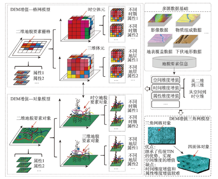 新窗口打开|下载原图ZIP|生成PPT
图1面向地貌学本源的DEM增值
Fig. 1Geomorphology-oriented value-added DEM
3.2 地形因子及其地形空间关系
DTA的核心研究之一是基于地形因子对地貌形态的定量表达。但是,自数字高程模型诞生以来,至今已提出了上百种地形因子。地形因子不同于数学变量,它只有与具体的地学问题相结合,才能反映其内涵与价值。例如,人们正是根据河流两侧不同距离、不同高程的台地,判断不同级别的河流阶地;根据黄土地貌中沟沿线对分水线的逼近距离,分析黄土侵蚀地貌发育的进程;根据群山山顶高度的一致性程度,分析地质历史时期的夷平面;根据风成地貌中新月形沙丘的走向,分析盛行风向;根据黄土现今地形与下伏第三纪原始古地形的相似性,分析地貌的继承性关系等。可见,基于地形因子及要素的空间关系来剖析地貌形态以及成因机理的分析方法,从一开始就是地貌学研究的基本方法。但当前,所提出的上百种地形因子,难以用来表达这种地形空间关系。更为重要的是,目前100多种地形因子实质上仍处于杂乱无章的状态,研究尚没有从地貌学本源问题出发,以科学的原则及依据,对当前的地形因子进行语义界定、功能剖析、归纳演绎、有效补缺、系统整合,形成集科学性、系统性、实用性于一体的地形因子体系(图2)。这个集成创新目标的实现,将为新一代的数字地形分析的出现奠定重要的基础。图2
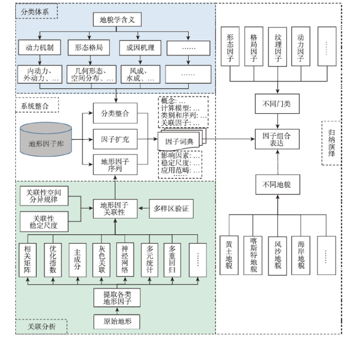 新窗口打开|下载原图ZIP|生成PPT
图2面向地貌学本源的地形因子分析
Fig. 2Geomorphology-oriented terrain derivative analysis
3.3 宏观地形分析
以往的数字地形分析都是以窗口分析为基本的分析方法,这种邻域分析在一定程度上解决了相邻栅格位置间的结构及其过程的模拟与表达。但是,它所存在“近视眼”的视野局限,使得DEM难以真正解决地理学重点需要解决的区域地貌分析与地貌制图难题。内外营力长期对地表物质作用,造就了宏观尺度大地貌区域格局和微观尺度上不同类型的地貌单元。研究中,既需要自下而上式的栅格单元聚类分析并实现地貌单元融合与归纳,也需要对地貌格局进行宏观解读并实现地貌单元自上而下式的分解与演绎。对于具有显著形态或地学属性变异的地貌对象,例如:地形起伏显著变化的黄土沟沿线、汇流方向显著变异的流域边界线等,基于邻域分析的DTA方法尚能有效提取。但是,对于涉及要素更为复杂、更依赖对周边地形空间关系综合分析的地貌,现有分析方法就显得捉襟见肘,甚至无能为力。必须走出栅格的“近视眼”分析束缚,提出新的空间分析理论与方法,实现科学的方法创新。此外,地貌分类与分区制图,往往是地貌学研究成果的有效体现。但是,地貌界线的划定有其相当的复杂性。纵观前人对黄土高原不同黄土地貌区的划定,就是对黄土地貌进行了充分的综合考察与多地形要素系统分析的结果。应当讲,目前海量、多分辨率的DEM数据的存在,以及多种地形因子的高精度自动提取,为开展地貌制图提供了重要的支撑。然而,地理边界问题,本身又是一个极为复杂、极为抽象、极为综合的理论难题,几十年前的地貌科学家们可以面对一张地形图和野外踏勘的感性认识,利用专家经验进行地貌边界的手动标绘。但在GIS时代,研究首先要做的是将这些地貌学家的思想进行科学的提炼,变为GIS可以识别的专家模型。为此,首先要厘清“地貌边界”这个具有地理学根本理论问题的科学内涵及地貌制图的技术需求;在此基础上,需要发展特征要素集分析法、图谱分析法、纹理分析法等一整套全新的地形分析新理论与新方法,最终形成地貌界线、格局与规律三者的有机整体,成为基于新一代DEM数据进行地貌分类与分区研究的重要理论探索与方法实践(图3)。图3
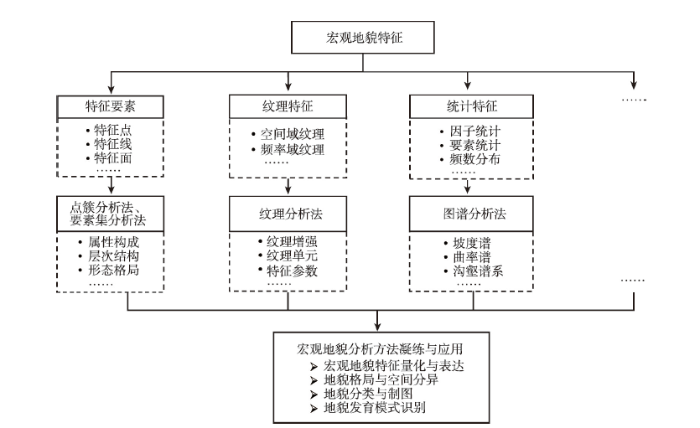 新窗口打开|下载原图ZIP|生成PPT
图3面向宏观地貌特征的宏观地形分析方法
Fig. 3Macro-terrain analysis methods for macro-geomorphological characteristics
4 结论与讨论
数字地形分析取得很大进展的今天,构建面向地貌学本源的新一代数字地形分析,是地貌学学科发展的必然要求。作为地理学中最基础的分支学科,地貌学也亟待通过现代地理信息科学理论与技术的发展与支撑,实现研究范式与重点从单纯的基于DEM的地貌形态研究,走向面向地貌学本源问题研究的根本转型。在研究中,如果忽略地貌只搞形态,研究将难以理解地貌形态特征与其物质组成的内在辩证关系,这种内在辩证关系的不完整认知,就可能会造成诸如对一般台地与河流阶地“形似而神不似”的认知误区;如果离开地貌空谈形态,研究将难以科学认知不同地貌发育时的内在成因机理,易于造成地貌认知上的本末倒置以及研究上的形而上学,从而缺乏正确理解地貌形成的自然规律、成因机理与形态特征之间的因果关系;如果任由形态脱离地貌,研究将难以有效解读不同发育模式下的地貌演化过程,难以准确认知地貌演化过程中的过去、现在与未来,形态研究也将会过于理想化,最终陷入地貌学研究中演化过程表达的“数字游戏”陷阱;如果形态没有走向地貌,研究将无法立足于地理学,科学解读地貌形态在空间上的分异格局,而这种分异格局往往是地球表面物质与能量在空间上分配与重组的界限与基础,是指导国土资源战略调整的重要因素。当前,数字地形分析进入到一个重要的发展瓶颈时期,已经形成了“基于DEM的地形因子与地形特征提取及可视化表达、地形特征统计与地貌分区制图”的分析范式。但是,数字地形分析研究急需从当前的地貌形态研究走向真正的面向成因机理、演化过程、及分异格局的地貌学本源研究。从当前的研究来看,面向地貌学本源的数字地形分析研究,在现有的研究基础上,亟需从不同的侧面进行突破。
(1)基于多种对地探测技术的发展,为地貌学深入研究地貌的成因、机理、过程创造了重要的条件,地貌学的发展也在呼唤现代地理信息技术的深度融合,呼唤通过对传统DEM及DTA的改造升级,特别是面向地貌学本源的数字地形分析的发展,推进地貌学、以及地理学的发展。
(2)现今,多尺度、高精度、全域覆盖的DEM数据体系已经形成,且各种地质、地表覆盖等其他要素数据也日益丰富。这些为DEM属性增值提供了有利的条件。因此,研究中应对当前DEM数据进行面向地貌学本源问题研究的属性增值。此外,地理信息科学领域应探讨对增值型DEM的数据模型与数据结构进行理论与方法。
(3)当前的DTA研究,无疑是以基于DEM的地形因子提取与分析为核心的。初步统计显示,已经提出的各种地形因子达到100多个。今后的研究应对其进行实际语义的标定、地貌学含义的标定及应用适宜性的标定;并有效提出对地貌学机理、过程、地貌要素空间关系、和区域地貌特征描述的地形因子。
(4)DTA方法在不断完善地形因子分析法、特征要素分析法、地形统计分析法的基础上,以我国科学家率先进行了地形信息图谱分析法、地貌发育机理与过程分析法的初步探索,在国际上独树一帜,形成了一定的特色与优势,为系统地进行面向地貌学本源的数字地形分析奠定了一定的基础,但成果是分散的、初探型的,亟待进行系统的顶层设计与研究规划。
诚然,本文没有指望数字地形分析的发展能够全面覆盖地貌学。一方面,当前的地貌学研究拥有丰富地貌专家知识与规则,它们是数字地形分析开展地貌学本源研究的重要基础,DTA即便实施了DEM数据增值、地形空间关系和宏观地形分析等研究,也替代不了业已形成的地貌专家知识与规则(如阶地成因知识与地貌演化规则)。另一方面,从地貌学研究来看,纵然是考虑了DEM、时间、地层、物质等因素的地貌演化模型,仍需要GIS数字地形分析研究中数据模型、数据结构、数据表达、数据分析、算法设计等多方面的支撑。此外,增值型DEM的构建并不仅仅是不同地貌要素数据层的简单叠加,而是从数据模型和数据结构的重构(即如图1中基于时空立方体和四面体等全新增值型DEM构建方法)。但是上述一系列研究侧面(或部分核心问题)的科学解答与突破,都将带来地貌学重要的理论创新与方法创新,同时丰富新时代的地理学的研究内涵。特别值得强调的是,构建面向地貌学本源的新一代数字地形分析,更是地理信息科学发展的必然要求。当今基于DEM的数字地形分析研究,正像当前的GIS是否能够真正支撑地理学发展一样,已经处于一个非常关键的十字路口。近年来,国内外科学家都在深入探索地理信息科学如何形成自身特有的理论体系与方法体系,如何走出当前数据处理与分析方法局限,真正支撑地理学及其他相应学科的发展,部分****更是在深入分析当前GIS发展存在问题的基础上,提出了“重新发现GIS”的构想。地理信息科学在得到大数据、人工智能、高性能计算等新兴技术支撑的今天,如果在分析理念、分析模式、分析方法上有重要突破,必将带来新的变革与突破性发展。面向地貌学本源的数字地形分析研究思路如果得以实现,可望成为地理信息科学领域理论与方法创新的一次重要探索与实践。特别是,如果中国科学家率先在数字地形分析理论与方法中带头展开该领域研究,并取得实质性突破,就可望进一步巩固我们在国际数字地形分析领域的优势与地位,并形成独具特色的“中国学派”。
参考文献 原文顺序
文献年度倒序
文中引用次数倒序
被引期刊影响因子
[本文引用: 1]
[本文引用: 1]
DOI:10.1126/science.1259172URLPMID:25593179 [本文引用: 1]

Our understanding of when and how humans adapted to living on the Tibetan Plateau at altitudes above 2000 to 3000 meters has been constrained by a paucity of archaeological data. Here we report data sets from the northeastern Tibetan Plateau indicating that the first villages were established only by 5200 calendar years before the present (cal yr B.P.). Using these data, we tested the hypothesis that a novel agropastoral economy facilitated year-round living at higher altitudes since 3600 cal yr B.P. This successful subsistence strategy facilitated the adaptation of farmers-herders to the challenges of global temperature decline during the late Holocene.
[本文引用: 1]
[本文引用: 1]
[本文引用: 1]
[本文引用: 1]
[本文引用: 1]
[本文引用: 1]
[本文引用: 1]
[本文引用: 1]
[本文引用: 1]
[本文引用: 1]
[本文引用: 1]
[本文引用: 1]
[本文引用: 1]
[本文引用: 1]
[本文引用: 1]
[本文引用: 1]
[本文引用: 1]
[本文引用: 1]
[本文引用: 1]
[本文引用: 1]
[本文引用: 1]
[本文引用: 1]
URL [本文引用: 1]
The Holocene sea-level rise of the Nile Delta is reconstructed on the basis of radiocarbon dates that are derived from 33 peat samples and 65 lagoon samples obtained from many boreholes located in the lower delta plain.The result indicates that the lagoonal curve is more reliable than that of the peat curve,the latter is much influenced by the sediment compact.The result also shows that the sea level was about 10 m below the present during 7 000 a B.P.,about 5 m below the present in 5 000 a B.P.,and was nearer to the present in 2 000 a B.P.Affected by the paleotopography and regional subsidence of the study area,the largest impact from transgressive intensity and scope tends to occur in the northeastern Nile sector.This influence becomes progressively reduced toward the central and northwestern Nile sectors.A vast Nile Delta Plain dominated by lagoon-sand beach and fluvial plain system had began to build at about 7 000 a B.P.,when rise in sea level started to decelerate and deltaic sedimentation rate overwhelmed the sea contribution.As sea level tends to be stabilized in Late Holocene,human activity,such as reclamation and channelisation,induces environmental deterioration,represented by largely shrunken lagoonal system.A comparable example of the Changjiang Delta is cited in the present study.It is shown that the Holocene Changjiang sea level did not fluctuate coincidentally as the Nile,much likely due to the differences of regional subsidence between the two regions.The fertile delta plain that was formed by the delta-coast construction at about 7 000 a B.P.induced the Neolithic civilization.However,intensifying human activity since 2000 a B.P.also has aggravated the delta-coast environment.Many lakes and drainage networks are diminishing.
[本文引用: 1]
[本文引用: 1]
[本文引用: 1]
[本文引用: 1]
[本文引用: 1]
[本文引用: 1]
[本文引用: 1]
[本文引用: 1]
[本文引用: 1]
[本文引用: 1]
[本文引用: 1]
[本文引用: 1]
[本文引用: 1]
[本文引用: 1]
[本文引用: 1]
[本文引用: 1]
[本文引用: 1]
[本文引用: 1]
[本文引用: 1]
[本文引用: 1]
[本文引用: 1]
[本文引用: 1]
DOI:10.1016/j.geomorph.2011.04.024URLPMID:22053124 [本文引用: 1]
The transition zone of the Eastern Alps to the Pannonian Basin provides one of the best sources of information on landscape evolution of the Eastern Alpine mountain range. The region was non-glaciated during the entire Pleistocene. Thus, direct influence of glacial carving as a landscape forming process can be excluded and relics of landforms are preserved that date back to at least the Late Neogene. In this study, we provide a correlation between various planation surfaces across the orogen-basin transition. In particular, we use stream terraces, planation surfaces and cave levels that cover a vertical spread of some 700 m. Our correlation is used to show that both sides of the transition zone uplifted together starting at least about 5 Ma ago. For our correlation we use recently published terrestrial cosmogenic nuclide (TCN) burial ages from cave sediments, new optically stimulated luminescence (OSL) ages of a stream terrace and U-Th ages from speleothems. Minimum age constraints of cave levels from burial ages of cave sediments covering the last ~ 4 Ma are used to place age constraints on surface features by parallelizing cave levels with planation surfaces. The OSL results for the top section of the type locality of the Helfbrunn terrace suggest an Early Wurm development (80.5 +/- 3.7 to 68.7 +/- 4.0 ka). The terrace origin as a penultimate gravel deposit (in classical Alpine terminology Riss) is therefore questioned. U-series speleothem ages from caves nearby indicate formation during Marine Isotope Stages (MIS) 5c and 5a which are both interstadial warm periods. As OSL ages from the terrace also show a time of deposition during MIS 5a ending at the MIS 5/4 transition, this supports the idea of temperate climatic conditions at the time of deposition. In general, tectonic activity is interpreted to be the main driving force for the formation and evolution of these landforms, whilst climate change is suggested to be of minor importance. Obvious hiatuses in Miocene to Pleistocene sediments are related to ongoing erosion and re-excavation of an uplifting and rejuvenating landscape.
DOI:10.1080/00385417.1970.10770483URL [本文引用: 1]
[本文引用: 1]
[本文引用: 1]
[本文引用: 1]
[本文引用: 1]
[本文引用: 1]
[本文引用: 1]
[本文引用: 1]
DOI:10.1016/j.geomorph.2009.07.004URL [本文引用: 1]
DOI:10.1016/j.geomorph.2013.02.008URL [本文引用: 1]
DOI:10.1007/s11442-009-0587-xURL [本文引用: 1]
Present granite landform characteristics and distribution are the integrated result of climate, tectonics and lithology. Various types of granite landforms in China signify climate zonality and differential vertical movement of earth surface, while published research results on Chinese granite landforms are very rare, especially in international journals. Based on the process analysis of chemical weathering and physical disintegration, four granite landform regions in China are classified according to the present climate regime. On the Tibetan Plateau, the cold and freezing climate induced periglacial landscapes; the northeast region is characterized by physical disintegration and low round mounds are widespread; in the northwest region controlled by arid climate, wind-carved minor landscapes are extremely prominent. The most spectacular granite landscapes in China are presented in southeast as a result of longtime chemical weathering under humid and warm conditions, as well as the differential uplift after Neogene. Correlating the weathering crust in southern China, Tibetan Plateau and India, a possible unified planation surface in Neogene is proposed. With corestones as indicators of original weathering front, the differential uplift extent of dissected planation surfaces can be estimated. At least three landforms implying uplift can be identified in southeastern China, with elevations of 300–400 m, 2000 m and 3600 m above the sea level respectively.]]>
[本文引用: 1]
[本文引用: 1]
[本文引用: 1]
[本文引用: 1]
[本文引用: 1]
[本文引用: 1]
[本文引用: 1]
[本文引用: 1]
[本文引用: 1]
[本文引用: 1]
[本文引用: 1]
[本文引用: 1]
[本文引用: 1]
[本文引用: 1]
[本文引用: 1]
[本文引用: 1]
[本文引用: 1]
[本文引用: 1]
[本文引用: 1]
[本文引用: 1]
[本文引用: 1]
[本文引用: 1]
[本文引用: 1]
[本文引用: 1]
[本文引用: 1]
[本文引用: 1]
[本文引用: 1]
[本文引用: 1]
[本文引用: 1]
[本文引用: 1]
[本文引用: 1]
[本文引用: 1]
[本文引用: 1]
[本文引用: 1]
[本文引用: 1]
[本文引用: 1]
[本文引用: 1]
[本文引用: 1]
[本文引用: 1]
[本文引用: 1]
[本文引用: 1]
[本文引用: 1]
[本文引用: 1]
[本文引用: 1]
[本文引用: 1]
[本文引用: 1]
[本文引用: 1]
[本文引用: 1]
[本文引用: 1]
[本文引用: 1]
[本文引用: 1]
[本文引用: 1]
[本文引用: 1]
[本文引用: 2]
[本文引用: 1]
[本文引用: 1]
[本文引用: 1]
[本文引用: 1]
[本文引用: 1]
[本文引用: 1]
[本文引用: 1]
[本文引用: 1]
[本文引用: 1]
[本文引用: 1]
[本文引用: 1]
[本文引用: 1]
[本文引用: 1]
[本文引用: 1]
[本文引用: 1]
[本文引用: 1]
[本文引用: 1]
[本文引用: 1]
[本文引用: 1]
[本文引用: 1]
[本文引用: 1]
[本文引用: 1]
[本文引用: 1]
[本文引用: 2]
[本文引用: 2]
[本文引用: 1]
[本文引用: 1]
[本文引用: 1]
[本文引用: 1]
[本文引用: 1]
[本文引用: 1]
[本文引用: 1]
[本文引用: 1]
[本文引用: 1]
[本文引用: 2]
[D].
[本文引用: 1]
[D].
[本文引用: 1]
[本文引用: 1]
[本文引用: 1]
[本文引用: 1]
[本文引用: 1]
[本文引用: 1]
[本文引用: 1]
[本文引用: 1]
[本文引用: 1]
[本文引用: 1]
[本文引用: 1]
[本文引用: 1]
[本文引用: 1]
[本文引用: 1]
[本文引用: 1]
URL [本文引用: 1]
This paper takes an overall review on the former researches firstly.Focus mainly on the concept,types,scaling effect,key problems of DEM scale,as well as its impact on DEM based digital terrain analysis.A few key research topics were put forward through an overall analysis of the research development in recent years,i.e.the property of scale conflict and scale matching between natural and DEM simulated surface;the principle and mechanism of how the spatial scale parameters impact the terrain analysis,the heterogeneity effect in terrain analysis within DEM grid cells.And then,from the view point of regional scale level,both the certainty and uncertainty property in digital terrain analysis should be investigated.In addition,more work should be done to establish a scale depended multi-scaled terrain analysis model as well as DTM scale converting models.Finally,the research development tendency was prospected.
[本文引用: 1]
DOI:10.3724/SP.J.1047.2009.00737URL [本文引用: 1]
[本文引用: 1]
[本文引用: 1]
[本文引用: 1]
[本文引用: 1]
DOI:10.3724/SP.J.1047.2015.00562URL [本文引用: 1]
Parallel raster- based programming libraries have been proposed to make the details of parallel programming and the parallel hardware architecture to be transparent to users in some degrees. Thus these libraries can facilitate the development of parallel programs of raster-based geocomputation. Among the existing parallel programming libraries, parallel raster-based geocomputation operators (PaRGO), which is recently proposed by Qin et al, shows great advantages. This is not only because PaRGO encapsulates the general steps in parallel raster- based geocomputation, but also because PaRGO is compatible with multiple commonly used parallel computing platforms. Currently, PaRGO is designed for supporting local operation, focal operation and global operation directly. However, the availability of PaRGO for supporting regional operation in raster-based geocomputation has not been evaluated. In this paper, we evaluate PaRGO to testify its performance in this circumstance by using a multiple-flow-direction algorithm as a representation of the regional operation. Different versions of PaRGObased parallel programs for this algorithm are tested on a symmetrical multiprocessing (SMP) cluster and evaluated from two aspects: the performability and the parallel efficiency. The experimental results show that the current PaRGO cannot directly support the parallelization of regional operations. But it can be supportive when the regional operation is transformed into an iteration process of focal operation. On a SMP cluster, MPI-version parallel program performs better than MPI/OpenMP-version parallel program.
[本文引用: 1]
[D].
[本文引用: 1]
[本文引用: 1]
[本文引用: 1]
[本文引用: 1]
DOI:10.11821/dlxb201409006URL [本文引用: 2]
Digital elevation model (DEM) is known to be one of the most important national fundamental geographic information data. The theory, method and application of digital terrain analysis (DTA) based on GIS is a hot research issue in geography, especially in the field of geographical information science. This paper makes an overall review on Chinese scholars’ contribution to the research of DEM and DTA, especially to DEM data model, uncertainty, analysis method, scaling effect and high performance computing method, as well as its application in DTA. A few research groups in this field have made great progress recently, and young scholars are playing a critical role in the process. Their research has caught up with the international forefront, and achieved fruitful results in significant innovation. Some research, like DEM based regional geomorphological research on the Loess Plateau and Tibetan Plateau of China highlighted the contribution of Chinese scientists, which have had influence in the international academia to a certain degree.
[本文引用: 2]
DOI:10.1016/j.geomorph.2010.09.029URL [本文引用: 2]
DOI:10.1111/cgf.1995.14.issue-3URL [本文引用: 1]
DOI:10.1080/13658816.2016.1205193URL [本文引用: 1]
[本文引用: 1]
[本文引用: 1]
URL [本文引用: 1]
Planation surface is a remnant of landform in old age and the erosion surface is of a mature landform, according to the Davisian cycle. Studies on the long-term landscape evolution show that there are four types of planation surface, peneplain, pediplain, double leveling surfaces and cryoplain. The peneplain is formed through lowering of relief in wet region. The pediplain is developed by slope retreating in dry region. The double leveling surfaces appeares in Savanna landscape. The cryoplain is formed in periglacial environment. Measurement of erosion rates and retreating rates of slope indicated that formation of planation surface needs the tectonic equability for severl million years or thousands million years. In the the Qinghai-Xizang Plateau, there are two planation surfaces and one erosion surface, Summit Surface, Main Surface and Erosion Surface. The Summit Surface have formed in the Oligocene and early Miocene, and the Main Surface between 20-3.6Ma B.P. Tectonics on the Qinghai-Xizang Plateau were relatively stable between 3.6Ma B.P. and 1.7Ma B.P. and the Erosion Surfaces was formed. Because the Main Surface is a "jumping-off point" of the Qinghai-Xizang Plateau, studies on its mode of formation and height have great significance in determining the altitude of the Qinghai-Xizang Plateau before uplift. Synthesizing the proofs from mammal fauna, regolith and geomorphology, we think the Main Surface was developed as a typical double level surface. There could be the peneplain in the south of it and the pediplain on north. Its altitude should not exceed 1000 m when it was formed. The Intense tectonic uplift, which resulted in the present Qinghai-Xizang Plateau with an altitude of 4500-5000m, happened in last 3.6Ma when the Main Surface was destroyed.
[本文引用: 1]
URL [本文引用: 1]
In the loess gullies, a series of key features points set play important roles such as central control and calibration for its Morphology and development. For the gully feature points set, systematically studying the scientific meaning, building the structural integrated data model, and studying the loess gully landform's spatial differentiation of evolutionary tracks and development by using the data model have important scientific significance and practical application value. So, the concept meaning of loess gully feature points cluster is presented and analyzed. Loess gully feature points cluster is a points'organic whole which plays a decisive role (such as gully head point, break point, et al.) or Calibration role of the terrain (such as gully node point, runoff source point, et al.) in a loess watershed. Based on DEM data, the gully feature points of a typical completed watershed in the loess landform are extracted. Using object-oriented modeling ideas, an unstructured file storage mode of the loess gully points cluster is researched and created. The data model can effectively describe a performance points cluster topology and spatial information. The loess gully points cluster model of test area is achieved through programming. A case study as the feature points retrospective sought, the processing efficiency is higher by comparing .shp data mode. The research results show that: the loess gully feature points cluster retains the key character of loess gully, and especially has obvious advantage on expressing the morphological structure characters. The points cluster space model uses the tree and non storage structure, so its structure is clear and its description information storage is simple. At the same time, the points cluster model application has higher efficiency in the valley spatial structure analysis.
[本文引用: 1]
[本文引用: 1]
[本文引用: 1]
DOI:10.1007/s11431-008-5002-9URL [本文引用: 1]
[本文引用: 1]
[本文引用: 1]
[本文引用: 1]
URL [本文引用: 1]
2, the HI tends to be stable, which is regarded as a critical area for extracting HI in this study. Then, the geomorphic feature HI is proposed and the correlation of each kind of HI is calculated. There exist two feature groups in which the correlation coefficient is rather large. They are respectively catchment HI, positive terrain HI, shoulder line HI and peak HI, ridge line HI, and catchment boundary HI. Finally, the landform division based on HI is created through multiresolution segmentation in loess area. The coupling relationships exist in this division and water & soil loss map, sediment transport value map. The division in this paper refines the original map to a certain extent.]]>
[本文引用: 1]
[D].
[本文引用: 1]
[D].
[本文引用: 1]
URL [本文引用: 1]
This article aims at making a comparative study of various schemes of geomorphological classification formulated both at home and abroad.By absorbing their strong points.Such classification is done by means of combining morphology with morphogenesis,taking into account the comprehensive indexes of geomorphological ages.The hierarchy of mountainous relief is classified in accordance with the indexes of the altitude ranging from 5,000m,3,500m to 800m as against the relative height of 200m to 100m.The continental geomorphology of our country is divided into 12 major types or groups and 5 major classes,as shown in the proposed table of geomorphological classification here attached(see Table2),which can be used for geomorphological mapping on different scales.
[本文引用: 1]
DOI:10.1007/s11442-011-0831-zURL [本文引用: 1]
Geomorphologic maps are one of the most fundamental materials of the natural environment. They have been widely used in scientific research, resource exploration and extraction, education and military affairs etc. An editorial committee was established in 2001 to collect materials for researching and compiling a set of new 1:1,000,000 geomorphologic atlas of China. A digital geomorphologic database was created with visual interpretation from Landsat TM/ETM imageries and SRTM-DEM etc. The atlas compiled from the database was finished. The main characteristics of the atlas are as follows: Firstly, Landsat TM/ETM imageries, published geomorphologic maps or sketches, geographical base maps, digital geological maps, and other thematic maps were collected, which were uniformly geometrically rectified, clipped into uniform sheets, and stored in the foundation database. Secondly, based on the legends of 15 sheets 1:1,000,000 maps published in the 1980s, a geomorphologic classification system was built by combining morphology and genesis types. The system comprised seven hierarchical layers: basic morphology, genesis, sub-genesis, morphology, micro-morphology, slope and aspect, material composition and lithology. These layers were stored in the database during visual image interpretation. About 2000 kinds of morphogenesis and 300 kinds of morpho-structure were interpreted. Thirdly, the legend system was built, which included color, symbol bases and note bases etc., compilation standards and procedures were developed, 74 sheets of 1:1,000,000 covering all land and sea territories of China were compiled, the 1:1,000,000 geomorphologic atlas of the People’s Republic of China was finished and published. The atlas will fill the blanks in national basic scale thematic maps, and the geomorphologic database could be applied widely in many fields in the future.
[本文引用: 1]
[本文引用: 1]
URL [本文引用: 1]
In the past one hundred years,the classification of landforms has been discussed considerably.Some authors called the terms like plain,platform,hill and mountain as basic morphologies but we think they are landform types,because these terms are defined not only by their morphological characteristics,but also by their formations.By systemically analyzing and evaluating the existing fundamental geomorphological classification systems,we consider that it is suitable to classify the complicated geomorphological types of China according to two main indicators,i.e.,relative relief height and absolute altitude above sea level.The first indicator is used to divide landforms into four types,i.e.,plain,platform,hill,and mountain.We here suggest to further divide them into seven types according to the relative relief height.They are plain,platform,hill(<200m),low relief mountain(200~500m),intermediate relief mountain(500~1000m),high relief mountain(1000~2500m),and extremely high relief mountain(>2500m).The second indicator is actually just the meters above the sea level.We propose to replace the previous classification criteria of modern snowline,lower boundary of permafrost,and upper boundary of forest belt by the elevation above sea level,because the exact heights of modern snowline,lower boundary of permafrost,and upper boundary of forest belt vary remarkably in China.Through observing the distribution pattern of mountain ridges' altitudes on topographic maps(1 ∶500000)of key regions in China and the distribution map of ground elevation(1 ∶1000000)in national digital topography model(DTM)database,we suggest the following criteria: Low altitude(<1000m),intermediate altitude(1000~2000m),sub-high altitude(2000~4000m),high altitude(4000~6000m),and extremely-high altitude(>6000m).Applying the classification system with seven types of the relative relief heights and five types of absolute altitudes,landforms in China can be divided into 28 basic geomorphological types(Table 1),ranging from low altitude plains to extremely high mountains.
[本文引用: 1]
[本文引用: 1]
[本文引用: 1]
[本文引用: 1]
[本文引用: 1]
[本文引用: 1]
[本文引用: 1]
DOI:10.1007/s11430-016-0211-5URL [本文引用: 1]
DOI:10.1002/esp.v41.9URL [本文引用: 1]
DOI:10.1016/j.geomorph.2013.12.009URL [本文引用: 1]
URL [本文引用: 1]
Desert geomorphic map can provide the basic information for studying deserts. Compilation of the Geomorphic Map of the Kumtagh Desert was listed as the basic work in the China National Sci-Tech Basic Work Program "Comprehensive Scientific Expedition of the Kumtagh Desert"(No. 2006FY110800). This paper presents the general ideas and technologies employed in compiling this thematic map. The scale of the map was determined to be 1∶350 000, considering the thematic details to be shown and the required specification of printing paper. 1∶250 000 topographic maps prepared in the 1970s were selected as the geography base maps, supplemented by the 1∶100 000 topographic maps for details of some elements. Thematic contents were based on TM data of 2000 to 2007, supplemented by the high-resolution images provided by Google Earth in some areas. The thematic contents included geomorphic types, height and activities. The geomorphic types were classified as aeolian landforms, fluvial landforms, dry denuded landforms, glacial and periglacial landforms and other landforms. Aeolian landforms were the key elements to be manifested in the thematic map. Aeolian landforms were classified into 13 types represented by symbols, their relative height represented by colours and activities represented by arrows. Primary dunes generally higher than 10 m were sited and those less than 10 m in height were non-sited to show the distribution and patterns of aeolian landforms and consider the limitation of mapping scale. Alluvial fans and dry streams were also the key factors to be presented because the Kumtagh Desert was developed on the inclined alluvial plains to the north of the Altyn Mountains. Computer mapping and digitization technology were applied to their best. All the information that could be digitized was digitized. Geomorphic Map of the Kumtagh Desert would provide rich information for studying this desert.]]>
[本文引用: 1]
DOI:10.11867/j.issn.1001-8166.2014.06.0734URL [本文引用: 1]
Aeolian geomorphology is formed by wind power in arid, semi-arid, and even humid regions. It is the study of the characteristics of land surface patterns, spatial combinations, formation, and development. Wind regime controls aeolian geomorphology patterns, spatial combinations, and development. Near surface air flow and aeolian flow control the development and movement of dunes. Recently, the field has developed rapidly. This paper summarized recent progress in aeolian geomorphology patterns, wind regime, and dune morphodynamics based on aeolian geomorphology observation methods, analysis method and morphodynamics. The new terrain observation techniques, such as Total Station and three dimensional terrain scanner, provided accuracy terrain data for morphodynamics study. Meanwhile, three dimensional sonic sensor measured high frequency field wind velocity data, which gave more information on the relationship between terrain and near surface air flow. However, the analysis method, such as the relationship between wind regime and dune types, high frequency wind velocity data and reciprocal relationship between dune pattern and near surface air flow, is still not solved.
[本文引用: 1]
[本文引用: 1]
[本文引用: 1]
[本文引用: 1]
[本文引用: 1]
[本文引用: 1]
[本文引用: 1]
[本文引用: 1]
[本文引用: 1]
URL [本文引用: 1]
2,or 6.77% of the total area,with an average retreat rate of 0.24 km2·a-1.Lake area was obviously in reduction in the last 30 years,shrinking from 1974 to 1999,but expanding from 1999 to 2003 to some extent.Many small lakes have disappeared.Lake shrinkage was smaller and smaller and then has shifted to lake expansion since 1999.But generally speaking,lake area was in shrinkage from 1974 to 2003,with a total area decrease of 37.58 km2,accounting for 4.81% of the total area,and an average retreat rate of 1.25 km2·a-1.In addition,the glacier and lake variations with meteorological data during the last 30 years in the basin were analyzed.According to meteorological data from the Burang Station(with an elevation of 3 900 m a.s.l.),which is located in the southwest of Mapam Yumco basin,the average air temperature increases very obviously.Temperature increase in the Mapam Yumco basin consists with a prevailing warming over the Tibetan Plateau during the last decades.Annual precipitation and annual evaporation decreased slightly as shown in its linear fitting.The glacier retreat was most likely due to the negative glacial mass balance and was affected by rising temperature and decreasing precipitation over the Tibetan Plateau.Early lake decrease was likely to be caused by less precipitation in the basin.On the other hand,lake expansion has accelerated since 1999,which was most likely due to more water supplies from intensive melting of glaciers,in addition to less water loss due to evaporation and less precipitation income in the basin.]]>
[本文引用: 1]
[本文引用: 1]
[本文引用: 1]
[本文引用: 1]
DOI:10.1016/j.geomorph.2006.04.013URL [本文引用: 1]
DOI:10.2136/sssaj2003.1810URL [本文引用: 1]
[本文引用: 1]
