 ,2, 程千钉3, 邬真真3
The sources and fate of nitrogen in groundwater under different land use types: Stable isotope combined with a hydrochemical approach
LU Lu1,2, DAI Erfu,2, CHENG Qianding3, WU Zhenzhen3通讯作者:
收稿日期:2018-05-31修回日期:2019-07-31网络出版日期:2019-09-25
| 基金资助: |
Received:2018-05-31Revised:2019-07-31Online:2019-09-25
| Fund supported: |
作者简介 About authors
路路(1985-),男,博士,主要从事土地利用变化下的环境效应研究E-mail:lulu@igsnrr.ac.cn。

摘要
关键词:
Abstract
Keywords:
PDF (2527KB)元数据多维度评价相关文章导出EndNote|Ris|Bibtex收藏本文
本文引用格式
路路, 戴尔阜, 程千钉, 邬真真. 基于水环境化学及稳定同位素联合示踪的土地利用类型对地下水体氮素归趋影响. 地理学报[J], 2019, 74(9): 1878-1889 doi:10.11821/dlxb201909013
LU Lu.
1 引言
土地利用类型是影响集约化农区内地下水体氮素污染的重要因素之一[1]。三江平原是中国“新增千亿斤粮食建设规划”的核心区域。受人类高强度农业开发活动的干扰,三江平原地区原生生态系统向农业生态系统大规模转变。这一过程打破了长期历史条件下形成的生态和水文平衡,破坏了原有的元素平衡,加快了氮素等营养物质的输移过程[2,3]。同时,不合理开采地下水使得区域性地下水位持续下降,加上大量农药化肥的使用,土壤中大量溶解态氮素向地下水运移,从而导致地下水环境质量持续恶化[4,5]。近年来,区域内正在实施大规模的“旱改水”工程,下垫面条件(如土地类型、地膜覆盖)的变化势必会对地下水补、径、排条件产生重要的影响,而施肥状态以及土壤水分环境的改变将直接影响到硝酸盐向地下水体的输入通量[6,7]。集约化农业活动所引发的地下水体中氮素污染早已经被农业、环境等研究领域证实[8,9,10],对于地下水体氮素的来源以及削减机制等相关信息仍缺少深入细致的调查研究,为何不同土地利用类型下地下水体氮素污染存在显著差别?大规模的土地变化对该区域地下水体中氮素污染的影响机制是什么?以上问题目前仍然难以做出合理科学的解释。同时,由于大规模的农业活动,原始的景观生态结构被改变,单一自然的生态环境被替换为更为复杂的生态环境,而这些具有混合土地利用类型的流域往往使得进行氮素归趋解析变得更为复杂[11,12]。
随着检测技术的进步,具有原位及过程标记特性的同位素技术,成为示踪氮素来源及迁移转化的有力工具。近年来,氮稳定同位素技术已经在示踪氮污染来源、氮素循环过程和氮肥利用率等方面得到广泛应用。已有的研究表明,δ15N-NO3-是区分水环境中硝酸盐来源(化肥、土壤有机质硝化以及污水粪便等)的重要指标,而δ18O-NO3-是区分硝酸盐化肥以及大气沉降来源的硝酸盐的重要指标。在氮循环的过程中往往涉及硝酸盐同位素的分馏作用,根据同位素δ值的改变可以有效地分析污染物在迁移过程中所发生的物理化学反应,有助于氮素在流域和水体中迁移转化规律的研究[13,14,15]。同时,水体中水化学特征可以提供一些辨别硝酸盐来源和氮循环过程的常规信息[16,17]。因此,硝酸盐同位素联合水化学信息能够有效示踪流域地下水体中氮素的来源和潜在的氮素循环过程。
本文采用水环境化学及同位素联合示踪法对土地利用类型影响下地下水体中氮素的归趋进行研究,拟揭示不同土地利用类型影响下,地下水体氮素时空变化特征,明确地下水体中氮素污染的成因及主要氮循环过程,阐明土地利用类型对地下水体氮素归趋的影响,以期为实现区域粮食安全生产和地下水环境安全协调发展提供技术支撑。
2 材料及方法
2.1 研究区域概况
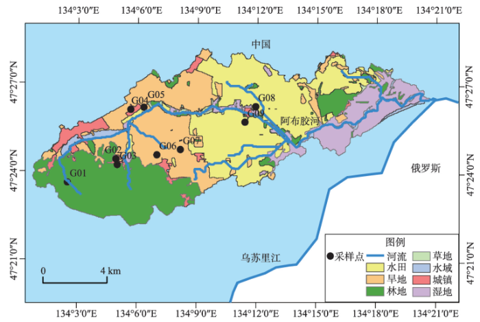
阿布胶河流域位于47°22′N~47°28′N、134°0′E~134°20′,流域面积约140 km2。该流域位于传统开发型国营农场内,从20世纪50年代起,经历过4次农业开发高潮,大规模的湿地向农业耕地转化,其开发模式及发展历程在三江平原农场群中具有较强的代表性及典型性。受温带大陆性季风气候影响,流域典型的气候特征是夏季炎热多雨,冬季寒冷干旱。在早春和晚冬季节主要呈现低温天气,最低月平均气温约为-19.27 ℃。夏季短暂而潮湿。进入10月份以后,气温迅速降到0 ℃以下。该流域内农业用地占总流域面积的56.12%、森林占25.41%、湿地占11.78%、建设用地占3.97%、其他用地类型约占2.72%(图1)。图1
 新窗口打开|下载原图ZIP|生成PPT
图1研究区域概况及采样点分布
Fig. 1Location of the study area and distribution of sampling sites
2.2 样品采集和分析
考虑到当地的气象及水文状况,项目组于2015年进行了3次地下水样采集,主要包括冻融期(4月)、丰水期(8月)、枯水期(11月)。水样采集依据流域内主要的土地利用类型设置相关采样点(图1),具体采样点信息如表1所示。Tab. 1
表1
表1地下水采样点采样信息
Tab. 1
| 采样点 | 井深(m) | 使用目的 | 土地利用类型 | 采样时间 |
|---|---|---|---|---|
| G01 | - | 泉水 | 森林 | 共计3次采样: 2015年4月10日; 2015年8月2日; 2015年11月6日; |
| G02 | 20 | 饮用 | 城镇 | |
| G03 | 23 | 饮用 | 城镇 | |
| G04 | 25 | 饮用 | 城镇 | |
| G05 | 78 | 饮用 | 城镇 | |
| G06 | 106 | 灌溉 | 玉米地 | |
| G07 | 32 | 灌溉 | 玉米地 | |
| G08 | 30 | 饮用、灌溉 | 水稻田 | |
| G09 | 27 | 饮用、灌溉 | 水稻田 |
新窗口打开|下载CSV
水样使用聚乙烯塑料瓶进行采集。采集时,先将采样瓶用待采集的水样润洗3次,以保证采样瓶中无空气残留,然后取约300 ml的水样装入瓶中,盖好瓶塞,置于4 °C移动冰箱中,尽快运回实验室。取水样的同时采用GPS测定并记录采样点的地理位置,在采集地下水时调查井深和使用功能并进行记录。此外,在取样现场,使用便携式多水质测定仪(YSI,USA)测定水体中的溶解氧(Dissolved Oxygen, DO)、总悬浮固体(Total dissolved solids, TDS)、pH值和水温等水质参数。
在实验室内,样品采集后24 h内,采用稀硫酸—甲基橙滴定法测定碳酸氢根离子(HCO3-)含量。之后所有待测样品使用0.45 μm醋酸纤维滤膜过滤后进行主要阴阳离子及同位素测定。其中阴阳离子测定在北京师范大学分析中心完成。水样中的铁锰离子含量通过电感耦合等离子体发射光谱仪(ICP,ULTIM,France,JY Company)进行测定,检测限为1 μg/L;样品中其它的阴阳离子浓度由离子色谱仪(Dionex,DX-600和 ICS-2100,USA)测定,检测限为0.01 mg/L,测定精度为1%。所有水样的阴阳离子平衡误差<10%。
水样中硝酸盐同位素测定采用反硝化细菌方法[18,19],在中国农业科学院稳定同位素实验室分析测试中心通过C/N质谱仪CE EA111进行δ15N的测定,δ18O通过MAT 253质谱仪进行测定。IAEA-N3的国际标准被用于δ15N和δ18O测量的校准。同位素测定分析精度为:δ18O < 0.9‰(平均值± 0.3‰)和δ15N < 0.3‰(平均值± 0.2‰)。
2.3 统计分析方法
所有样品数据使用SPSS 20 软件进行统计分析处理。在本研究中,首先使用SPSS对所有数据进行正态分布检验(采用洛夫—斯米尔诺夫检验)以及方差的同质性检验(Levene test)。如果数据没有达到正态分布或者方差同质性的假设,采用基于非参数检验的方差分析(Kruskall-Wallis ANOVAs test)进行下一步的数据分析。采用多变量方差检验(ANOVA检验)来评估各氮素以及主要离子浓度的时间(季节)和空间(位置)之间的差异。在此基础上,通过主成分分析来探求流域内氮素污染的潜在来源。3 结果分析
3.1 地下水体中氮素的污染特征
研究区域地下水氮素浓度分布如表2所示。其中NO3-含量约占DIN含量的90%以上,为14.57±16.55 mg/L,其中最大值为57.18 mg/L,约为地下水环境质量标准(GB/T14848-2017)Ⅲ类水限值(简称标准限值)20 mg/L的2.86倍。NH4+含量为0.30±0.63 mg/L,其中最大值为1.93 mg/L,约为标准限值0.5 mg/L的3.86倍。NO2-含量为0.01±0.002 mg/L,低于标准限值0.02 mg/L。上述结果表明,研究区域内地下水体中存在严重的氮素污染,部分点位超出标准限值近4倍,对区域人群健康具有潜在的危害。Tab. 2
表2
表2地下水体中溶解态无机氮素浓度含量统计特征(mg/L)
Tab. 2
| 统计量 | NO3- | NH4+ | NO2- |
|---|---|---|---|
| 极小值 | 0.04 | Nulla | 0.006 |
| 极大值 | 57.18 | 1.93 | 0.013 |
| 均值 | 14.56 | 0.30 | 0.01 |
| 标准差 | 16.55 | 0.63 | 0.002 |
| 质量标准 | 20b | 0.5b | 0.02b |
新窗口打开|下载CSV
区域地下水体中氮素浓度随时间波动较小(P > 0.05),而空间分布上具有显著的差异(P < 0.001),主要受土地利用类型影响。不同土地利用区域地下水NO3-含量分别为:30.14±12.01 mg/L(城镇)> 4.46±2.03 mg/L(旱田)> 2.18±0.32 mg/L(林地)> 0.12±0.10 mg/L(水田);而NH4+含量主要分布在水田区域,为1.44±0.66 mg/L,其他区域均未检出。此外,氮素组成同样受土地利用类型影响,在城镇、旱田、林地区域内主要以硝态氮为主(样品中NO3-/TIN > 99%),然而在水田区域内则以铵态氮为主(NH4+/TIN > 85%)。
3.2 地下水体水化学特征
Piper图能够反映地下水环境化学成分组成及演化,结合氮素浓度分布进行分析,是进行地下水体氮素污染研究的重要手段[20,21]。因此,通过绘制Piper图来研究区域地下水体中水环境化学演变特征(图2)。由piper图可知,该流域内地下水类型主要属于Ca2+-Cl--HCO3-、以及Na+-HCO3--Cl--NO3-类型。地下水体中阳离子以Na+为主,阴离子以HCO3-为主(表3)。阳离子浓度由高到低分别为Na+(30.75±26.56 mg/L)>Ca2+(24.73±12.38 mg/L)>Mg2+(15.97±10.47 mg/L)>K+(1.74±2.45 mg/L)>Fe2+(1.30±2.41 mg/L)>Mn2+(0.30±0.44 mg/L);阴离子浓度分别为HCO3-(49.67±22.18 mg/L)>Cl-(21.56±23.34 mg/L)>SO42-(12.29±14.39 mg/L)。图2
 新窗口打开|下载原图ZIP|生成PPT
图2研究区域地下水Piper图
Fig. 2Piper diagram of ions in groundwater in the study area
Tab. 3
表3
表3地下水水环境化学特征统计信息(mg/L)
Tab. 3
| 统计量 | 极小值 | 极大值 | 均值 | 标准差 |
|---|---|---|---|---|
| Na+ | 1.69 | 101.83 | 30.75 | 26.56 |
| K+ | 0.31 | 10.2 | 1.74 | 2.45 |
| Mg2+ | 2 | 40.56 | 15.97 | 10.47 |
| Ca2+ | 6.2 | 51.54 | 24.73 | 12.38 |
| Cl- | 0.11 | 58.28 | 21.56 | 23.34 |
| SO42- | 0.04 | 52.48 | 12.29 | 14.39 |
| HCO3- | 7.86 | 75.72 | 49.67 | 22.18 |
| Fe2+ | Nulla | 6.69 | 1.3 | 2.42 |
| Mn2+ | Nulla | 1.44 | 0.3 | 0.44 |
新窗口打开|下载CSV
地下水水化学分布受土地利用类型所控制,在空间上具有明显的演变趋势。其中在阿布胶河源头,地下水主要以泉水形式存在,水岩之间的交互作用明显,主要化学类型显示为Ca2+-SO42-、Ca2+-HCO3-等类型。在中下游城镇地区,主要化学类型向Na+-Ca2+-HCO3--Cl--NO3-转变,较高的NO3-、Na+及Cl-离子浓度表明,地下水体中硝态氮污染与人类生活排污密切相关。在其下游的旱田区域,主要化学类型转变为Ca2+-HCO3--NO3-;在水田地区Ca2+-HCO3-成为主导离子,NH4+离子浓度较高。
3.3 主成分分析结果
为进一步探求地下水体中氮素的潜在来源,本文对地下水环境中各离子进行主成分分析,尝试通过解析离子之间的内部结构关系,探究地下水中氮素的归趋。在主成分分析过程中,采用特征根大于1作为主成分选择标准,选取2个主成分内容:第一主成分(PC1)以及第二主成分(PC2),其方差分别占总方差的46.48%,以及27.57%。根据主成分分析结果(表4),第一主成分(PC1)包括离子NO3-、Na+、K+、Mg2+、Ca2+、Cl-、SO42-,第二主成分(PC2)主要包括离子HCO3-、NH4+、Fe2+、Mn2+。Tab. 4
表4
表4主成分分析成分矩阵以及旋转成分矩阵结果
Tab. 4
| 变量 | 成分矩阵 | 旋转成分矩阵a | ||
|---|---|---|---|---|
| 主成分1 | 主成分2 | 主成分1 | 主成分2 | |
| SO42- | 0.907 | 0.200 | 0.931 | -0.099 |
| Mg2+ | 0.873 | 0.338 | 0.898 | -0.237 |
| NO3- | 0.861 | -0.062 | 0.861 | -0.189 |
| Cl- | 0.853 | -0.126 | 0.844 | 0.031 |
| Na+ | 0.852 | 0.226 | 0.770 | -0.076 |
| K+ | 0.737 | 0.414 | 0.738 | -0.449 |
| Ca2+ | 0.719 | 0.285 | 0.701 | -0.502 |
| HCO3- | 0.102 | 0.782 | -0.257 | 0.861 |
| NH4+ | -0.578 | 0.664 | -0.211 | 0.855 |
| Fe2+ | -0.622 | 0.648 | -0.212 | 0.760 |
| Mn2+ | -0.536 | 0.579 | 0.449 | 0.649 |
| 累积贡献率(%) | 53.275 | 74.056 | 46.481 | 74.056 |
新窗口打开|下载CSV
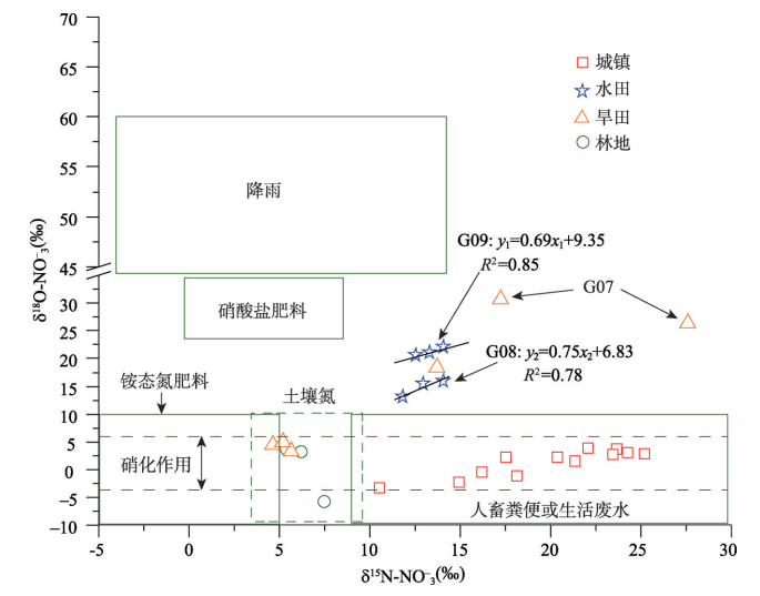
3.4 地下水硝酸盐同位素特征
地下水体中δ15N-NO3-和δ18O-NO3-值的时空变化特征(图3)。其中,地下水体中δ15N-NO3-值为15.19±6.79‰,位于4.67‰~27.59‰之间;δ18O-NO3-值为7.84±9.87‰,位于 -5.79‰~30.78‰之间。与氮素浓度时空变化趋势类似,硝酸盐氮氧同位素值不存在显著的时间变化趋势,而空间变化趋势较为显著。其中,δ15N-NO3-含量为19.83±4.42‰(城镇)>13.14±0.88‰(旱田)>12.36±9.09‰(水田)>6.38±1.08‰(林地)。δ18O-NO3-含量分别为18.05±3.65‰(水田)>14.70±12.17‰(旱田)>1.19±2.43‰(城镇)>0.30±5.28‰(林地)。水环境化学及同位素特征的空间变化,暗示着土地利用类型对氮素循环过程及来源具有较大的影响。图3
 新窗口打开|下载原图ZIP|生成PPT
图3地下水体中δ15N-NO3-及δ18O-NO3-变化特征
Fig. 3Trends of δ15N-NO3- and δ18O-NO3- variations during the sampling period
4 讨论
4.1 土地利用类型对地下水体中氮素循环过程的影响
土地利用类型的变化势必会对植被、土壤、微生物种群等因素产生重要的影响,进而直接间接影响地下水体中氮循环过程,致使氮循环过程具有显著差异[22]。硝化反应是水体中一个重要的氮循环过程,是在硝化细菌的作用下水体中的铵态氮逐渐削减的过程。在此过程中,由于微生物偏好质子较轻的元素,使得在硝化过程中所产生的硝酸盐氮、氧同位素值较轻,其残留物中的元素较重,引起同位素分馏。硝化过程中δ15N和δ18O的分馏系数取决于当地的环境条件和反应速度。室内硝化作用试验结果表明:在硝化过程中产生的NO3-中的氧,通常有1/3来自于大气,其余2/3来自周围的水体。因此,硝化过程的发生可以由水体中δ18O-NO3-值的范围来指示。与硝化作用相反,反硝化作用通常会导致残留的NO3-中的氮、氧同位素富集,造成同位素分馏。反硝化程度主要取决于所消耗的硝酸根离子浓度。研究表明:在反硝化过程中δ15N-NO3-增加值约为δ18O-NO3-增加值的1.5~2.0倍,并且这种线性关系可以用于指示反硝化过程的发生[23]。参照Lu等[24]的研究成果,该区域内硝化作用δ18O-NO3-理论计算值范围位于-4.04‰~6.15‰。通过样品δ18O-NO3-观测值与理论计算值进行对比分析可知(图3b、图4),在森林(G01)、城镇(G02~G05)及旱田(G06)深水井等区域的样品的δ18O-NO3-观测值位于理论计算值范围之内,约占总样品数量的63%,表明在林地及城镇区域内,硝化作用是其主导的氮循环过程。
图4
 新窗口打开|下载原图ZIP|生成PPT
图4地下水中硝酸盐同位素组成关系图
Fig. 4The composition of nitrate isotope in groundwater
在农田区域(G07~G09)样品δ18O-NO3-的观测平均值为20.43‰,最小值为13.10‰,远高于理论计算值上限值6.15‰,约占总样品数量的约33%。较高的δ18O-NO3-值可能与反硝化过程、降雨以及硝酸盐肥料混合过程有关。依据当地施肥习惯,区域肥料施用主要为还原性氮肥,因此,可以排除样品中高δ18O-NO3-值来源于硝酸盐肥料的可能。
根据研究区硝酸盐的同位素组成关系图(图4)可知:在水田区域内,δ15N-NO3-跟 δ18O-NO3-存在显著的线性相关关系。其中,采样点G08、G09样品中δ15N-NO3-跟δ18O-NO3-线性关系:
同时,该区域地下水体中较低的溶解氧(0.8±0.2 mg/L),利于反硝化过程产生(反硝化作用一般发生在DO浓度< 0.1~2 mg/L的情况下[25])。以上结果表明,在水田区域内,反硝化过程是主导的氮素循环过程。
旱田采样点G07同样具有较高的δ15N-NO3-和δ18O-NO3-值,但二者线性关系并不明显,可能受反硝化及雨水混合过程等多重影响。其中,δ18O-NO3-的最大值出现在8月份(雨季),较高的降雨量可能会对地下水产生补给作用,致使δ18O-NO3-值升高。
4.2 土地利用类型对地下水体氮素来源的影响
4.2.1 基于同位素示踪方法 结合区域内潜在硝酸盐来源同位素分布范围,采用双同位素联合示踪法[25](bi-plot approach,δ15N-NO3-和δ18O-NO3-)识别地下水体中主要的NO3-来源。图4显示,氮素的来源具有显著的空间差异。其中,林地及旱田深水井样品的δ15N-NO3-和δ18O-NO3-值位于土壤有机氮来源范围内(表5),结合该区域内主要氮循环过程,表明该区域硝态氮主要来源于土壤中有机氮素的硝化反应。城镇区域δ15N-NO3-跟δ18O-NO3-位于粪便及生活废水源范围内(表5),表明城镇区域生活源氮素输入是影响区域地下水质的重要因素。该结果与Matiatos[11]及Barnes等[26]的研究结果较为一致,林地水体中硝酸盐主要受土壤不饱和带控制,土壤有机氮硝化作用是其主要来源,而城镇区域粪便及污水是影响地下水中硝酸盐分布的重要因素。Tab. 5
表5
表5硝酸盐潜在污染源同位素值分布
Tab. 5
| 来源 | δ15N-NO3-(‰) | δ18O-NO3-(‰) |
|---|---|---|
| 降雨 | -13~13 | 25~75 |
| 粪便及废水 | 4~25 | -5~10 |
| 土壤氮 | -3~8 | -10~10 |
| 还原性氮肥 | -6~6 | -10~10 |
新窗口打开|下载CSV
水田区域及旱田浅水井内的水样,受反硝化等过程影响,硝酸盐同位素发生较大的同位素分馏作用,已改变同位素的初始信号,具有较高的δ15N-NO3-和δ18O-NO3-值,已超出潜在污染源同位素范围,从而硝酸盐同位素进行溯源解析时受到限制[27,28]。
4.2.2 基于主成分分析(PCA)方法 地下水中较高的硝酸盐含量一般与生活废水的注入、下渗以及农业活动密切相关。一般城镇区域中地下水高含量的硝态氮往往伴随着大量营养盐类的注入如:NaCl等。而SO42-离子除了来源于石膏以及硫酸矿物盐的的溶解外,人类活动所产生的有机质的分解也是其主要来源[29]。本文将各样品在第一主成分上的得分按照采样点的土地利用类型进行分类(图5a),各样品在第一主成分上的得分由人类活动影响区向自然区域递减(城镇>旱地>水田>森林),证明了区域内高浓度的硝酸盐与人类活动密切相关,因此,第一主成分为硝态氮污染,主要来源于生活污水。
图5
 新窗口打开|下载原图ZIP|生成PPT
图5不同土地利用类型中第一及第二主成分得分箱体图
Fig. 5The box plots of the first and second principal components for different land use types
在地下水环境中,HCO3-、NH4+主要来源于还原态氮肥的施入,如碳酸氢铵(NH4HCO3)和尿素(H2NCONH2(CO(NH2)2))。一般情况下,铵肥施用到农田中,会受到硝化作用影响生成大量的硝酸盐,由于NH4+离子带正电荷被大量吸附在土壤中,而生成的硝酸盐由于易迁移性将会经过不饱和带大量地进入地下水。然而,由于水田环境处于长期厌氧条件下,硝化作用受到抑制,且较高的田间持水量将会增加NH4+离子在不饱和带的迁移性致使其进入地下水中[30]。地下水环境中较高浓度的Fe2+离子会抑制地下水中硝酸根的产生,由于其还原作用使得地下水中硝酸盐被去除[31]。按照采样点的土地利用类型进行分类(图5b),各样品在第二主成分上的得分由农业区域向其他区域递减(水田>旱地>城镇>森林)。因此,第二主成分因子代表“铵态氮污染”,主要来源于水田还原性氮肥。
4.2.3 基于同位素及水化学方法联合示踪 根据同位素及水环境化学(PCA)源解析结果可知:基于同位素示踪方法能够有效示踪林地、城镇等区域硝态氮来源,而农业区域内,由于受反硝化等过程影响,在微生物的作用下,硝酸盐同位素往往发生较大的同位素分馏作用,改变同位素的初始信号,导致原本界限清晰的各个污染来源的硝酸盐同位素变得模糊不清,从而使得运用硝酸盐同位素进行溯源解析时受到限制。而基于地下水水化学特征的“PCA”方法(聚类分析)难以识别森林区域内氮素来源,但对于城镇、旱田等区域内的高浓度硝态氮及水田区域内的铵态氮的来源具有较好的指示效果。
在森林区域内,地下水主要化学类型显示为Ca2+-SO42-、Ca2+-HCO3-等类型,表明地下水体元素主要是水岩交互产物,为自然本底来源。同位素示踪结果表明该区域内氮素主要来源于土壤有机氮硝化过程。因此通过联合示踪能够进一步揭示该区域内氮素来源结果。
在城镇区域内,地下水主要化学类型向Na+-Ca2+-HCO3--Cl--NO3-转变,NO3-、Na+及Cl-浓度及主成分1得分较高,表明该区域硝态氮污染与城镇生活排污密切相关。同时,地下水体硝酸盐同位素位于典型的粪便及生活废水源范围内,同样证明了地下水体中较高的硝态氮污染来源于城镇生活源。因此,通过联合示踪能够相互验证区域内氮素来源结果。
在水田区域内,铵态氮污染严重,同时由于反硝化过程致使同位素来源示踪受限。而水环境化学聚类分析结果表明,该区域主成分2得分最高,铵态氮污染与水田还原性氮肥密切相关。由此可见,通过联合示踪能够补充该区域氮素来源识别工作的缺陷,进一步提高氮素污染解析的精度。
5 结论
(1)研究区域内,地下水体中存在严重的氮素污染,主要受土地利用类型影响,部分点位超出标准限值近4倍,其中硝态氮污染区域主要位于城镇区域,铵态氮污染主要位于水田区域,对区域人群健康具有潜在的危害。(2)地下水类型主要属于Ca2+-Cl--HCO3-以及Na+-HCO3--Cl--NO3-类型,在空间上具有明显的演变趋势,受土地利用类型所控制。上游林地区域属于Ca2+-SO42-、Ca2+-HCO3-等类型,水岩交互作用明显。中游城镇区域受生活源污染影响,向Na+-Ca2+-HCO3--Cl--NO3-类型转变。受化肥施入影响,下游旱田区域转变为Ca2+-HCO3--NO3-类型,水田地区转变为Ca2+-HCO3-类型。
(3)同位素示踪研究结果显示,不同土地利用类型下氮素循环过程有着显著的差异,林地及城镇区域内,硝化作用是其主导的氮循环过程,在水田区域存在着显著的反硝化过程,而在旱田区域可能受反硝化及雨水混合过程等多重影响。
(4)基于同位素及离子联合示踪结果表明,不同土地利用类型下氮素来源同样有着显著的差异,林地区域主要来源于土壤有机氮;城镇区域主要来源于粪便及废水;农田区域主要来源于还原性肥料。基于水环境化学解析和同位素示踪法相互补充,能够进一步提高地下水体氮素污染解析的精度。
(5)本研究证实了土地利用类型不仅是影响地下水体氮素浓度和水化学类型演变的主导因素,而且对区域氮素循环过程及来源具有重要的影响。研究成果能够丰富人们对高纬度地区不同景观单元在地下水体氮素输送过程中所扮演的角色及不同土地利用类型对地下水体中氮素的补给来源及途径的认识。同时,本研究成果有助于深入了解高纬度农区地下水循环演化过程、氮素污染的成因以及土地利用变化对地下水污染的影响机制,从而为开展重大政策对地下水资源影响评价等工作提供理论依据。
参考文献 原文顺序
文献年度倒序
文中引用次数倒序
被引期刊影响因子
DOI:10.1007/s11442-006-0403-9Magsci [本文引用: 1]

<a name="Abs1"></a>Taking the typical karst agricultural region, Xiaojiang watershed in Luxi of Yunnan Province as a research unit, utilizing the groundwater quality data in 1982 and 2004, the aerial photos in 1982 and TM images in 2004, supported by the GIS, we probe into the law and the reason of its space-time change of the groundwater quality over the past 22 years in the paper. The results show: (1) There were obvious temporal and spatial changes of groundwater quality during the past 22 years. (2) Concentrations of NH <sub>4</sub> <sup>+</sup> , SO <sub>4</sub> <sup>2−</sup> , NO <sub>3</sub> <sup>−</sup> , NO <sub>2</sub> <sup>−</sup> , Cl<sup>−</sup> and the pH value, total hardness, total alkalinity increased significantly, in which NH <sub>4</sub> <sup>+</sup> , NO <sub>3</sub> <sup>−</sup> , and NO <sub>2</sub> <sup>−</sup> of groundwater exceeded the drinking water standards as a result of non-point pollution caused by the expansion of cultivated land and mass use of the fertilizer and pesticide. (3) Oppositely, Ca<sup>2+</sup> and HCO <sub>3</sub> <sup>−</sup> showed an obvious decline trend due to forest reduction and degradation and stony desertification. Meantime, there was a dynamic relation between the groundwater quality change and the land use change.
[本文引用: 1]
[本文引用: 1]
[本文引用: 1]
[本文引用: 1]
.
[本文引用: 1]
[本文引用: 1]
[本文引用: 1]
[本文引用: 1]
[本文引用: 1]
[本文引用: 1]
[本文引用: 1]
[本文引用: 1]
[本文引用: 1]
[本文引用: 2]
[本文引用: 1]
[本文引用: 1]
DOI:10.1016/j.watres.2008.12.048Magsci [本文引用: 1]
<h2 class="secHeading" id="section_abstract">Abstract</h2><p id="">Nitrate (NO<sub>3</sub><sup>−</sup>) contamination of surface- and groundwater is an environmental problem in many regions of the world with intensive agriculture and high population densities. Knowledge of the sources of NO<sub>3</sub><sup>−</sup> contamination in water is important for better management of water quality. Stable nitrogen (<em>δ</em><sup>15</sup>N) and oxygen (<em>δ</em><sup>18</sup>O) isotope data of NO<sub>3</sub><sup>−</sup> have been frequently used to identify NO<sub>3</sub><sup>−</sup> sources in water. This review summarizes typical <em>δ</em><sup>15</sup>N- and <em>δ</em><sup>18</sup>O-NO<sub>3</sub><sup>−</sup> ranges of known NO<sub>3</sub><sup>−</sup> sources, interprets constraints and future outlooks to quantify NO<sub>3</sub><sup>−</sup> sources, and describes three analytical techniques (“ion-exchange method”, “bacterial denitrification method”, and “cadmium reduction method”) for <em>δ</em><sup>15</sup>N- and <em>δ</em><sup>18</sup>O-NO<sub>3</sub><sup>−</sup> determination. Isotopic data can provide evidence for the presence of dominant NO<sub>3</sub><sup>−</sup> sources. However, quantification, including uncertainty assessment, is lacking when multiple NO<sub>3</sub><sup>−</sup> sources are present. Moreover, fractionation processes are often ignored, but may largely constrain the accuracy of NO<sub>3</sub><sup>−</sup> source identification. These problems can be overcome if (1) NO<sub>3</sub><sup>−</sup> isotopic data are combined with co-migrating discriminators of NO<sub>3</sub><sup>−</sup> sources (e.g. <sup>11</sup>B), which are not affected by transformation processes, (2) contributions of different NO<sub>3</sub><sup>−</sup> sources can be quantified via linear mixing models (e.g. SIAR), and (3) precise, accurate and high throughput isotope analytical techniques become available.</p>
[本文引用: 1]
DOI:10.1007/s12665-011-1320-5Magsci [本文引用: 1]
The nitrate of groundwater in the Gimpo agricultural area, South Korea, was characterized by means of nitrate concentration, nitrogen-isotope analysis, and the risk assessment of nitrogen. The groundwaters belonging to Ca-(Cl + NO3) and Na-(Cl + NO3) types displayed a higher average NO3 (-) concentration (79.4 mg/L), exceeding the Korean drinking water standard (< 44.3 mg/L NO3 (-)). The relationship between delta O-18-NO3 (-) values and delta N-15-NO3 (-) values revealed that nearly all groundwater samples with delta N-15-NO3 (-) of +7.57 to +13.5aEuro degrees were affected by nitrate from manure/sewage as well as microbial nitrification and negligible denitrification. The risk assessment of nitrate for groundwater in the study area was carried out using the risk-based corrective action model since it was recognized that there is a necessity of a quantitative assessment of health hazard, as well as a simple estimation of nitrate concentration. All the groundwaters of higher nitrate concentration than the Korean drinking water standard (< 44.3 mg/L NO3 (-)) belonged to the domain of the hazard index < 1, indicating no health hazard by nitrate in groundwater in the study area. Further, the human exposure to the nitrate-contaminated soil was below the critical limit of non-carcinogenic risk.
[本文引用: 1]
[本文引用: 1]
[本文引用: 1]
[本文引用: 1]
[本文引用: 1]
[本文引用: 1]
[本文引用: 1]
[本文引用: 1]
[本文引用: 1]
[本文引用: 1]
[本文引用: 1]
[本文引用: 2]
[本文引用: 1]
DOI:10.1007/s11356-010-0422-zMagsci [本文引用: 1]
Background Environmental agencies have to take measures to either reduce discharges and emissions of nitrate or to remediate nitrate-polluted water bodies where the nitrate concentrations exceed threshold values. Isotope data can support the identification of nitrate pollution sources and natural attenuation processes of nitrate.<br/>Review This review article gives an overview of the information available to date regarding nitrate source apportionment in surface waters with the ambition to help improving future studies. Different isotope approaches in combination with physicochemical and hydrological data can successfully be used in source apportionment studies. A sampling strategy needs to be developed based on possible nitrate sources, hydrology and land use. Transformations, transport and mixing processes should also be considered as they can change the isotope composition of the original nitrate source.<br/>Conclusion Nitrate isotope data interpreted in combination with hydrological and chemical data provide valuable information on the nitrate pollution sources and on the processes nitrate has undergone during its retention and transport in the watershed. This information is useful for the development of an appropriate water management policy.
DOI:10.1016/j.watres.2012.03.004Magsci [本文引用: 1]
N-15 and O-18 isotope abundance analyses in nitrate (NO3-) (expressed as delta N-15-NO3- and delta O-18-NO3- values respectively) have often been used in research to help identify NO3- sources in rural groundwater. However, questions have been raised over the limitations as overlaps in 6 values may occur between N source types early in the leaching process. The aim of this study was to evaluate the utility of using stable isotopes for nitrate source tracking through the determination of delta N-15-NO3- and delta O-18-NO3- in the unsaturated zone from varying N source types (artificial fertiliser, dairy wastewater and cow slurry) and rates with contrasting isotopic compositions. Despite NOT concentrations being often elevated, soil water nitrate poorly mirrored the N-15 content of applied N and therefore, delta N-15-NO3- values were of limited assistance in clearly associating nitrate leaching with N inputs. Results suggest that the mineralisation and the nitrification of soil organic N, stimulated by previous and current intensive management, masked the cause of leaching from the isotopic prospective. delta O-18-NO3- was of little use, as most values were close to or within the range expected for nitrification regardless of the treatment, which was attributed to the remineralisation of nitrate assimilated by bacteria (mineralisation immobilisation turnover or MIT) or plants. Only in limited circumstances (low fertiliser application rate in tillage) could direct leaching of synthetic nitrate fertiliser be identified (delta N-15-NO3- < 0 parts per thousand and delta O-18-NO3- > 15 parts per thousand). Nevertheless, some useful differences emerged between treatments. delta N-15-NO3- values were lower where artificial fertiliser was applied compared with the unfertilised controls and organic waste treatments. Importantly, delta N-15-NO3- and delta O-18-NO3- variables were negatively correlated in the artificial fertiliser treatment (0.001 <= p <= 0.05, attributed to the varying proportion of fertiliser-derived and synthetic nitrate being leached) while positively correlated in the dairy wastewater plots ( p <= 0.01, attributed to limited denitrification). These results suggest that it may be possible to distinguish some nitrate sources if analysing correlations between 6 variables from the unsaturated zone. In grassland, the above correlations were related to N input rates, which partly controlled nitrate concentrations in the artificial fertiliser plots (high inputs translated into higher NO concentrations with an increasing proportion of fertiliser-derived and synthetic nitrate) and denitrification in the dairy wastewater plots (high inputs corresponded to more denitrification). As a consequence, nitrate source identification in grassland was more efficient at higher input rates due to differences in 6 values widening between treatments. (C) 2012 Elsevier Ltd. All rights reserved.
[本文引用: 1]
[本文引用: 1]
[本文引用: 1]
[本文引用: 1]
