 , 柴彦威, 关美宝
The impact of the uncertain geographic context on the space-time behavior analysis: A case study of Xining, China
TANYiming, CHAIYanwei, KWANMei-Po通讯作者:
收稿日期:2016-08-26
修回日期:2016-11-25
网络出版日期:2017-04-20
版权声明:2017《地理学报》编辑部本文是开放获取期刊文献,在以下情况下可以自由使用:学术研究、学术交流、科研教学等,但不允许用于商业目的.
基金资助:
作者简介:
-->
展开
摘要
关键词:
Abstract
This research makes an attempt to address the multivariable analysis as well as the temporal variations in the research of UGCoP. Two inter-related questions are explored in this research: First, how the contextual effects on different aspects of individual behaviors (and their inter-relationships) may be affected by the delineation of geographic context. Second, how the uncertainty of geographic context is evident in terms of the day-to-day variations.
This exploration is based on an empirical study of activity-travel behavior in Xining, China. An activity-diary dataset collected in 2013 and including 1098 valid samples is applied. The research first delineates the contextual unit of the built environment variables in two different ways: one is merely based on the residential neighborhoods, and the other considers both residential neighborhoods and activity spaces. Then, the research testifies the hypothesis about the potential impact of uncertain geographic context on the space-time behavior analysis. Also, the results on the weekday and weekend are compared in order to testify the day-to-day variation. Based on ANOVA test, geo-visualization, and the structural equation modelling, the study yields several findings. First of all, the geographic context based on residential neighborhood may lead to misunderstanding results, such as overestimating the contextual effects of neighborhood areas, and underestimating those of other activity places. Secondly, the effects of geographic context on individual behaviors show significant differences between the weekday and weekend.
These results imply that expanding our analytical focus to human mobility will considerably enrich our understanding on geographic context. The findings reveal trends similar to those observed in Western cities. Overall, addressing themes like these calls for further application of the space-time behavior perspective in revisiting and re-conceptualizing the traditional constructs.
Keywords:
-->0
PDF (1259KB)元数据多维度评价相关文章收藏文章
本文引用格式导出EndNoteRisBibtex收藏本文-->
1 引言
在地理学的人文化与社会化背景下,城市空间研究也在经历相同的转型过程,立足于人类空间行为的视角,正在成为理解城市空间的关键[1]。近年来,伴随着城市研究新数据源与方法论的兴起[2-4],时空间行为的研究逐渐从宏观走向微观,由现象走向机制[5]。与此同时,从时空间整合的角度反思和修正传统的概念与方法,成为时空行为研究的重要发展趋势。当基于地理要素来解释和预测个体行为,探讨居民行为与城市空间互动机制时,研究者已经对地理单元划分可能影响空间变量作用效应的分析结果,即可修正性地理单元问题(modifiable areal unit problem, MAUP)进行了广泛的关注[6-8]。但对同样影响到分析结果的地理背景不确定性问题的讨论尚处于起步阶段。
地理背景不确定性问题(uncertain geographic context problem, UGCoP)由关美宝[9]提出,指地理空间变量对个体行为作用效应的分析结果,可能受到地理背景单元或者邻里单元的划分方法及其与真实地理背景作用空间的偏离程度的影响。目前针对该问题的研究主要包括探讨活动地点的动态性[10-11]、不同测度方式下地理背景的差异性[12]、以及基于传统的居住视角解释行为的局限性[13-14]等方面。中国****在对地理背景的研究,主要集中在居住地的建成环境对行为的影响,将日常活动空间作为地理背景范围判读行为模式的研究相对欠缺。针对地理背景不确定性问题,国内****已开始逐渐关注,具体研究涉及地理背景的时间不确定性[15]、不同地理背景范围内的建成环境对出行行为的影响[16],但仍缺乏地理背景不确定性对行为模式要素间复杂关系分析时的影响的讨论。
在此背景下,本文基于西宁市的实证研究,尝试验证地理背景不确定性对行为模式分析的影响,并重点讨论两个方面的问题:第一,地理背景的不确定性如何影响其对多个行为变量的作用效应以及变量间的相互关系的分析结果;第二,地理背景的不确定性是否还表现在日间差异上。研究比较了两种地理背景范围下(仅考虑居住地的地理背景范围、综合考虑居住地与活动地的地理背景范围),建成环境、居民社会经济属性以及居民时空行为(包括时间利用、出行行为及活动空间)之间相互关系的差异性。
2 文献综述与理论假设
2.1 活动空间视角的地理背景解读的必要性
虽然已有研究采用多种方法,如人口普查分区、街区、交通小区以及通过缓冲区界定地理背景范围[17-18],但大部分界定方法与相关研究主要基于居住区视角,分析与居住地相关的地理环境对行为的影响[19]。而居住区作为人们活动发生的场所之一,并不能够完全涵盖人们在相关环境影响中的暴露。事实上,人通过时间、空间上的移动来完成日常活动[20-23],这种移动的结果使得人所受到的地理背景影响随着时间与空间而不断发生变化。例如,Wiehe等[11]对青少年危险行为的研究发现,被调查者活动的地点在一天中不断变化。健康相关研究中也认为,传统的基于居住地的地理环境与个人实际的活动地区地理环境存在差异[24]。因此,仅关注居住空间、不考虑这种动态变化特征,可能会导致地理背景变量无法合理、有效地界定,造成研究结果的谬误[9]。Kwan[13]在比较家庭人口普查范围和活动空间地理背景在大小和形状方面差异时发现,基于家庭人口普查范围的结果会趋向于高估邻里效应的不良影响。由此可见,引入活动空间视角的地理背景对行为模式与其影响因素进行分析是十分有必要的。此外,Kwan[9]认为这种地理背景的不确定性不仅体现在空间维度(即存在于真实空间环境对个体的背景效应),还体现在时间维度(即存在于个体经历这些背景影响的发生与持续的时间)。Wiehe等[11]的研究也发现除了一天中不同时间的变化,参与者活动地点也发生较明显的逐日变化。特别是工作日与休息日之间,除活动的时间分配的不同外[25],活动地点与其经历的地理背景也存在明显的差异[26-28]。这些研究结果揭示了基于传统静态地理背景可能忽视不同时刻及日间的差异,因此,研究中应加入对时间不确定性带来的地理背景动态性的考虑。
2.2 地理背景不确定性对行为模式分析影响的模型框架
地理背景的不确定性意味着即使其他因素都相同,分析结果也会因为背景单元的差异而不同[9, 29-30]。本文假设:当采用相同样本时,即使社会经济属性变量以及活动时间、出行、活动空间等行为要素变量保持不变,而仅改变地理背景的界定方式(如从仅考虑居住地到综合考虑居住地与活动地),社会经济属性对行为模式的影响以及行为要素间的相互关系或影响程度也会产生显著的差异。结合已有研究,对居民行为模式的讨论主要包括时间利用、出行行为和活动空间等方面。时间利用方面,时间地理学框架下的活动时间利用强调时空制约下个体所表现出的日常行为的时间安排[31]。不同活动的划分标准为活动时间利用赋予了不同的含义。Reichman[32]在Chapin[33]的活动分类基础上,将活动分为维持生计活动(Subsistence)、维护生活活动(Maintenance)和娱乐休闲活动(Leisure)3大类。这种划分被广泛应用和扩展修正到之后的活动分类研究中[34-35]。本文采用Andreev等[36]修正后的3大类活动进行活动时间利用研究,分别为强制性活动(Mandatory activities)、维护性活动(Maintenance activities)和可支配活动(Discretionary activities)。根据活动基于出行的理论观点[37],出行是活动的派生需求,即出行的产生是为了满足个体在不同地点的活动的需求,因此,个体参与不同活动系列决定了出行的产生与时空分布。而活动空间是对时空间行为的一种概况性的度量方式,是对个体活动机会认知范围的近似测度[38]。个人活动空间和时间及其派生的出行关系的研究最早可以追溯到Chapin[33]提出的整合活动类型、时间及空间的个人选择模型。在此后的研究中,活动空间和时间、出行的联系一直是****关注的重要内容。
为验证地理背景不确定性对行为模式分析的影响,结合已有研究结论,构建模型框架(图1)。总体上,社会经济属性与地理背景共同影响居民行为模式。研究比较两类地理背景:仅考虑居住地周边设施的地理背景、以及综合考虑居住地与家外活动地周边设施的地理背景。行为模式要素分别选择居民的时间利用、出行行为和活动空间几个方面:活动时间利用决定派生的出行行为,同时出行又反馈到活动时间分配上,活动与出行特征共同影响活动空间情况。其中,活动时间上以强制性活动优先,可支配活动最灵活,即强制性活动影响维护性活动和可支配活动时间,维护性活动时长也对可支配活动存在影响。研究从两方面讨论关于地理背景不确定性问题的假设:① 分别以仅居住地、综合考虑居住地与活动地作为地理背景范围,比较社会经济属性对行为模式的影响以及行为要素间的相互关系或影响程度的差异;② 考虑到地理背景范围存在日间差异,分别构建工作日、休息日模型,比较社会经济属性对行为模式的影响以及行为要素间的相互关系或影响程度的差异。
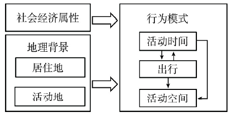 显示原图|下载原图ZIP|生成PPT
图1研究模型框架
-->Fig. 1Conceptual framework of the research
-->
3 研究区域与研究数据
3.1 研究区概况
本文选取西宁市为研究地理背景的不确定性对居民行为模式分析影响的案例地区。西宁市是青海省省会与经济文化中心,2013年全市人口220.87万人,是青藏高原地区唯一一个人口超过百万的中心城市。西宁市现辖城东、城中、城西、城北4个区,大通、湟中、湟源3个县,另外设有西宁(国家级)经济技术开发区、城南新区、高新技术开发区(生物科技产业园区)和海湖新区①(①数据来源:西宁市统计局.西宁统计年鉴(表1-7). 2013: 54.)。市区(城东区、城中区、城西区、城北区,及城南新区与海湖新区)沿湟水河河谷布局,整体呈现放射“十字”形空间格局。城市行政机构相对集中在“十字地带”几何中心,商业、娱乐设施以旧城区(即几何中心稍偏东侧区域)为中心,城市各区域建成环境差异明显,适于进行地理背景不确定性相关研究。此外,地理背景的讨论是从空间—行为互动视角理解中国城市空间与居民行为空间关系的重要探索。西宁市作为西部城市,其河谷型城市结构、相对滞后于东部沿海城市的发展现状,以及独具特色的城市社会人文等特征,都是在考虑不同城市规模、结构等方面的复杂性与多样性后,所进行的中国时空行为研究的西部典型案例城市补充。3.2 研究数据
本文选取西宁市主城四区(含海湖新区和城南新区)中典型居住区进行研究。研究数据包括居住区调查数据、基础地理数据,地理兴趣点(POI)数据等城市空间数据,以及居民基本信息、惯常行为与48小时活动日志等居民行为数据。城市空间数据主要运用城市路网、河流等城市基础地理数据和基于POI数据等的城市建成环境信息。本文中POI数据包括商业零售、餐饮娱乐、公交车站布局等与居民日常生活密切相关、并直接作用于时空行为的设施名称、类别和地理坐标等地理信息,适于进行地理背景问题的相关分析。
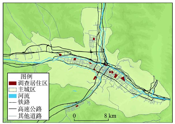
居民行为数据主要来源于2013年9月15日(星期日)与9月16日(星期一)在青海省西宁市进行的居民日常活动与交通出行调查。研究人员基于2013年7-9月在西宁市进行的居住区城市空间调查结果,综合考虑地理位置、住区类型、人口构成等方面,选取15个居住区进行抽样调查(图2)。调查中每个居住区随机选取100户家庭(每户家庭调查男家长与女家长两人),共计调查3000个居民样本。调查采用纸质问卷的方式对居民的家庭信息、惯常活动、社会经济属性以及居民连续48小时的活动日志进行记录。最终获得有效样本2598个(含仅家庭、个人信息与惯常活动完整,但48小时活动日志部分缺失的样本),有效率为86.6%。其中活动日志部分填写完整且良好的样本共1690人。
 显示原图|下载原图ZIP|生成PPT
图2调查居住区区位
-->Fig. 2The location of the research area
-->
为综合居住地、活动发生地周边城市建成环境,关注地理背景不确定性对行为模式分析的影响,本文选取48小时内有家外活动的1098个样本作为研究对象,基本情况如表1所示。调查样本以西宁市户籍居民为主,男女比例相近,大部分调查样本年龄在30~50岁区间,25.5%的居民拥有本科及以上学历,54.7%居民月收入在2000~5000元之间,仅9.3%的居民收入高于5000元,36.9%的居民拥有驾驶执照,31.5%的居民家中有小汽车。
Tab. 1
表1
表1被调查者社会经济属性
Tab. 1Sample characteristics in Xining
| 变量 | 样本数(个) | 百分比(%) | |
|---|---|---|---|
| 性别 | 男 | 578 | 52.6 |
| 女 | 520 | 47.4 | |
| 年龄(岁) | <30 | 102 | 9.3 |
| 30~50 | 670 | 61.0 | |
| >50 | 326 | 29.7 | |
| 收入(元) | <2000 | 395 | 36.0 |
| 2000~5000 | 601 | 54.7 | |
| >5000 | 102 | 9.3 | |
| 教育程度 | 初中及以下 | 395 | 36.0 |
| 高中或大专 | 427 | 38.9 | |
| 本科及以上 | 276 | 25.1 | |
| 户籍 | 西宁户籍 | 928 | 84.5 |
| 非西宁户籍 | 170 | 15.5 | |
| 驾照 | 有 | 405 | 36.9 |
| 无 | 693 | 63.1 | |
| 汽车所有权 | 有小汽车 | 345 | 31.5 |
| 无小汽车 | 753 | 68.5 |
新窗口打开
4 动态地理背景引入行为分析的必要性
为讨论综合考虑日常活动的地理背景(例如活动空间内的建成环境)对行为模式分析的意义,本文关注活动时间的家内、家外分配,活动地点与居住地点空间分布的差异性,说明使用传统静态地理背景范围界定方法的局限性与动态地理背景引入的必要性。同时,由于地理背景的不确定性具有时间维度,并表现在日间差异方面,本文分别对样本的工作日与休息日活动时间利用与活动地点分布进行分析。4.1 活动时间与空间的动态性
利用西宁市居民48小时活动日志调查数据,将原活动类别分为强制性活动、维持性活动和可支配活动3大类,分析样本的活动时间家内、家外分配,以及工作日、休息日两天的活动时间利用差异。其中,强制性活动包括工作和与工作相关的能够产生收入的活动,维护性活动包括个人事务(睡眠、用餐、个人护理、外出办事等活动)、家庭照料(含家务和照料)、购物消费等以满足个人及家庭的需求维护的活动,可支配活动包括休闲活动(体育锻炼、娱乐休闲和观光旅游)等自由活动。活动时间(含睡眠)在地点分配上以家内为主,有近三分之一的时间在家外进行活动,这一结论与Wiehe关于青少年女孩危险行为研究的时间分配结果相近[11]。不同类型的活动家内、家外时间分配差异显著:工作等强制性活动几乎全部发生在家外,离家特征明显;维护性活动具有较强的向家倾向,该类活动平均10%左右的时间在家外进行,其他时间则分配在家内,主要为个人事务、家庭照料等维护生活活动;休闲等可支配活动方面,家内活动时间约占三分之二;另有平均每日40 min左右的时间花费在出行上。
日间差异上(表2),居民工作日平均家外强制性活动的时间显著长于休息日,两日相差约1小时。强制性活动所需花费的时间的缩短,使得居民可以将更多的时间分配在家庭与个人生活、购物消费与休闲娱乐上:休息日,居民在家内与家外的个人、家庭事务、购物、休闲上的分配的时间均长于工作日,且差异显著,即维护性活动与可支配活动的平均用时均显著高于工作日。
Tab. 2
表2
表2居民活动时间利用差异性
Tab. 2Difference of time allocation to various activities
| 工作日 | 休息日 | F值 | |||||
|---|---|---|---|---|---|---|---|
| 平均值(min) | 标准差 | 平均值(min) | 标准差 | ||||
| 强制性活动 | 家内 | 13.61 | 69.100 | 10.77 | 59.727 | 5.767*** | |
| 家外 | 293.30 | 259.980 | 156.55 | 249.284 | 3.258*** | ||
| 维护性活动 | 家内 | 763.25 | 183.876 | 798.23 | 184.300 | 2.663*** | |
| 家外 | 71.60 | 117.623 | 103.68 | 144.324 | 4.523*** | ||
| 可支配活动 | 家内 | 179.76 | 158.602 | 201.70 | 161.339 | 5.327*** | |
| 家外 | 76.61 | 142.051 | 126.10 | 170.492 | 6.472*** | ||
| 出行 | 41.87 | 38.472 | 42.98 | 40.593 | 7.953*** | ||
新窗口打开
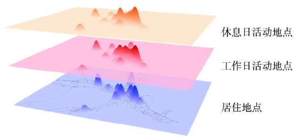
空间分布方面,基于工作日、休息日两天家外活动地点与居住地点的地理坐标,利用ArcGIS 10.3软件进行核密度估计(利用活动持续时间进行加权),生成活动地点分布的密度表面,并在三维环境下进行可视化(图3)。一方面,居民活动地点分布与居住地之间存在一定程度的匹配关系,说明居住地周边的设施可以满足居民的部分日常活动需求,即居住地是居民日常活动的一个重要锚点,其周边地理环境会影响居民的行为模式;另一方面,除各样本居住地附近外,城市中心也是家外活动密度较高的地区之一,这是由于中心城区商业、休闲设施相对集中,同时工作机会较多,为居民活动提供了便利的场所,可见活动地点周边的地理环境同样会作用于居民的行为。此外,工作日与休息日由于强制性活动所需分配的时间上存在差异,居民在休息日拥有更多的机会进行购物消费、休闲娱乐等活动,在空间分布上表现为城市几何中心(政府机构集聚地)活动密度降低,而城市商业中心活动更为集中。
 显示原图|下载原图ZIP|生成PPT
图3活动地点与居住地点空间分布及其日间差异
-->Fig. 3Difference of activity locations and home locations on the weekday and weekend
-->
总体上,活动时间方面,家外活动在全天时间分配上占有较大比例,如果排除睡眠等单一、不依赖于环境设施的活动,这一比例会进一步提高。活动地点方面,活动的发生不仅仅依赖于家这一锚点,居住地以外的城市空间中存在着密度较高的日常活动。同时,这种动态性也体现在工作日与休息日间差异上。如果仅从居住空间的静态地理背景出发,忽视活动中建成环境变化与日间差异,即缺乏对地理背景不确定性的考虑而解读行为模式,那么分析结果可能会与实际情况存在偏差。
4.2 地理背景的空间与时间差异
结合本文研究问题,为验证地理背景的动态性特征,综合考虑西宁城市空间尺度与居民步行可达范围,进行地理背景测度。参照已有研究,特别是针对面向居民生活质量的餐饮、公共交通站点等建成环境设施,一般以500 m(即5~7 min步行可达范围)作为步行可接受范围,采用同心圆方法考察其中的微环境特征[39-40]。同时西宁城市空间尺度与中心城区设施分布广泛、密集,且很少存在阻隔步行的立交桥等设施,适于采用500 m同心圆作为测度范围[16, 41]。因此在进行地理背景测量时:① 以居住地为中心取半径500 m的同心圆作为地理背景测度范围,计算居住地周边的设施密度;② 基于所有家外活动点生成半径500 m的缓冲区,取各缓冲区的并集作为地理背景测度范围,计算活动点周边的设施密度。地理背景内部设施POI分别采用餐饮娱乐设施、零售商业设施和公交车站3类,其中商业零售设施承载购物等维护生活活动,餐饮娱乐设施主要为可自由支配活动场所,公交车站密度用以衡量公共交通出行的便捷性与居民可达性。基于居住地和基于活动地点计算的3类设施密度存在显著差异(表3)。休息日活动地及周边零售商业、餐饮娱乐设施密度均最高,而工作日最低,居住地周边设施密度居中,同时居住地及周边零售商业、餐饮娱乐设施密度个体间差异均大于活动地。这可能是由于:① 被调查居住区区位分布存在差异,部分居住区临近中心商业区,周边设施密度较高,即使是城区边缘的居住区,其周边一般也会有购物设施与公共设施可供进行部分日常生活,因此设施密度相对较高;且公共交通多根据人口分布布局,因此居住地公交车站密度最高;② 工作日受工作等强制活动影响,居民活动主要依托工作地与家展开,维护活动和可支配活动发生率相对较少,对除购物娱乐设施使用需求不高,因此设施密度较低。与此相对应,休息日更有机会前往商业、娱乐设施集中的中心地区进行家外活动,因此,休息日活动点周边零售商业、餐饮娱乐设施密度最大。
Tab. 3
表3
表3建成环境的空间与时间差异
Tab. 3Spatial and temporal variations of built environment
| 平均值 | 标准差 | 差异显著性 | ||
|---|---|---|---|---|
| 零售商业 | 居住地设施密度 | 89.67 | 96.64 | - |
| 工作日活动地设施密度 | 82.00 | 88.02 | 0.00 | |
| 休息日活动地设施密度 | 96.17 | 92.78 | 0.00 | |
| 餐饮娱乐 | 居住地设施密度 | 68.67 | 72.20 | - |
| 工作日活动地设施密度 | 65.16 | 66.08 | 0.00 | |
| 休息日活动地设施密度 | 75.57 | 68.02 | 0.00 | |
| 公交站 | 居住地设施密度 | 5.82 | 2.72 | - |
| 工作日活动地设施密度 | 4.43 | 3.04 | 0.00 | |
| 休息日活动地设施密度 | 4.75 | 2.86 | 0.00 |
新窗口打开
从这些居住地与活动地之间的设施密度差异,及设施密度的日间差异可以看到西宁市案例地区地理背景在空间与时间上具有动态性与不确定性,适于进行地理背景不确定性对居民行为模式解析的影响研究。
5 地理背景界定方式对时空行为分析的影响
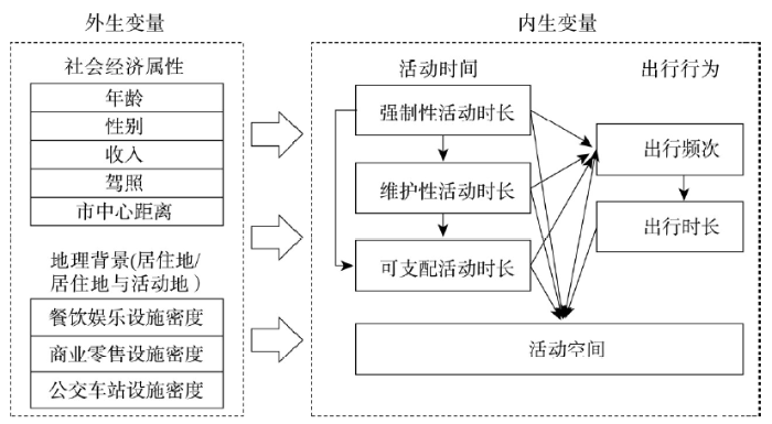
为研究地理背景不确定性问题对时空分析的影响,采用结构方程模型(SEM)进行定量化计算。结构方程模型能较为有效地分析不同维度的行为指标之间复杂的相互关系,为综合考虑日常活动与其派生出行间的直接关系、各类日常活动之间的相互作用以及出行对活动参与的反作用机制等提供了一个整体框架[42],并有助于解析个人社会经济属性、建成环境等外部因素对上述时空行为微观机理的影响,因此为研究地理背景不确定性问题对时空分析的影响提供了良好的方法基础。在本文中,居民社会经济属性与不同地理背景下的建成环境作为外生变量,居民的活动时间利用、出行情况与活动空间等行为指标作为内生变量。内生变量具体包括:家外强制性活动时间、维护性活动时间、可支配活动时间,出行频次,出行时长,活动空间面积。根据已有研究,建立结构方程模型影响框架及变量间相互关系如图4所示。工作等强制性活动所受到的时间制约最为严苛,其次是维护性活动,可支配活动时间安排最灵活,因而活动时间上强制性活动会影响维护性活动和可支配活动的时间分配,同时维护性活动也会对时间安排最为灵活性的可支配活动造成影响[43-44]。而出行作为活动的派生需求,即出行的产生是为了满足个体在不同地点的活动的需求,因此个体参与不同活动系列决定了出行的产生与时空分布。出行作为连接不同地点活动的行为,其需求强度、方式、耗时等都与个体所参与的活动密切相关[45],并反过来影响活动安排,主要表现为出行影响活动时长上[46],而出行频率对出行时长存在正向影响[47]。活动空间和时间、出行的联系一直是****关注的重要内容,但对空间的度量多使用距离变量,难以反映个人活动空间模式的复杂性。基于GIS的地理可视化和地理计算技术的发展,丰富了个人活动空间的测度方法(如标准差椭圆、最小凸多边形、缓冲区等),并被纳入到活动空间和时间、出行的联系的模型中加以讨论[48]。Ma等[38]的研究表明,个人活动空间的大小是建成环境、个人社会经济属性等因素综合作用的结果,但当控制了工作地区位之后,建成环境成为活动空间的主要影响因素,而个人社会经济属性对其的影响则较弱。结合已有研究,活动持续时间、出行都对活动空间存在影响[47-49]。
 显示原图|下载原图ZIP|生成PPT
图4模型变量间关系框架
-->Fig. 4Framework of the relationships among variables in the models
-->
模型在控制居民社会经济属性的同时,重点考察不同地理背景下建成环境特征对行为分析的影响。居民社会经济属性包括性别、年龄、个人收入、驾照情况和家庭拥有小汽车数量。建成环境在不同模型中,分别采用仅居住地周边、居住地与活动地周边商业零售、餐饮娱乐和公交站3类设施密度。出行频次为全天出行次数,出行时长为整日出行所用时间总和。考虑到西宁市“十字形”城市空间结构,基于最小凸多边形与标准差椭圆等方法生成的活动空间会涵盖山区等实际不能利用的空间范围,且研究表明最短路径缓冲区分析相较于椭圆与多边形方法而言与建成环境关系更为密切[50],因此利用ArcGIS 10.3中的网络分析方法,沿西宁市路网生成最短路径,进而构建最短路径的500 m缓冲区范围,进行活动空间的刻画。分别对工作日以居住地为地理背景范围(模型1)、工作日以居住地及活动地为地理背景范围(模型2)、休息日以居住地为地理背景范围(模型3)、休息日以居住地及活动地为地理背景范围(模型4)进行SEM计算,模型的主要拟合指标情况如表4所示。
Tab. 4
表4
表4模型拟合指标
Tab. 4Goodness-of-fit indicators of the models
| CMIN/DF | RMSEA | CFI | |
|---|---|---|---|
| 模型1 | 2.17 | 0.033 | 1.000 |
| 模型2 | 2.33 | 0.035 | 0.999 |
| 模型3 | 2.93 | 0.042 | 0.999 |
| 模型4 | 3.09 | 0.044 | 0.998 |
| 参考范围 | 2.00~5.00 | <0.100 | >0.900 |
新窗口打开
表5分析了工作日不同地理背景对行为模式分析的影响。首先,从行为变量相互关系(即内生变量间的相互影响)来看,不同地理背景下,变量间路径系数的大小及其显著性有一定的差异。仅考虑居住地的地理环境时,家外可支配活动时长及出行频次对活动空间范围并没有显著影响,而加入活动空间地理环境后,出行频次越高活动空间面积可能越大,同时家外的可支配活动时间也对活动空间范围存在显著影响;居民社会经济属性方面,拥有驾照会带来家外维护性活动时间的减少趋势,这与已有研究[51]和一般认识有所不同,但当加入活动点地理背景时,拥有驾照对家外维护活动时长并无显著影响;建成环境与区位方面,不考虑活动空间地理背景时,居住地周边商业、娱乐设施的密度会对活动时长、出行频次、时长均存在影响,而综合考虑居住地与活动地的地理背景时发现,居住空间的一些设施类别不再显著影响活动与出行行为,这与实际上工作日活动更多的依赖家外活动空间、特别是工作地周边设施进行相一致,说明单纯的以居住空间为地理背景范围,会导致夸大“家”对行为模式的影响,并有可能出现对一些影响因素的忽视和偏差(如只参考居住地周边,零售商业设施密度对购物等维护性活动是不存在显著影响的)。
Tab. 5
表5
表5工作日不同地理背景对行为模式分析影响的SEM模型
Tab. 5SEM on the impact of different geographic context measures on space-time behavior on the weekday
| 家外强制性 活动时长 | 家外维护性 活动时长 | 家外可支配活动时长 | 出行频次 | 出行时长 | 活动空间 | ||||||||
|---|---|---|---|---|---|---|---|---|---|---|---|---|---|
| 居住地 | 居住地+活动地 | 居住地 | 居住地+活动地 | 居住地 | 居住地+活动地 | 居住地 | 居住地+活动地 | 居住地 | 居住地+活动地 | 居住地 | 居住地+活动地 | ||
| 年龄 | -0.33*** | -0.34*** | -0.11*** | -0.12*** | 0.14*** | 0.13*** | -0.05* | ||||||
| 性别 | -0.08** | -0.08** | -0.05* | -0.05* | -0.07** | -0.07** | |||||||
| 收入 | 0.29*** | 0.30*** | 0.06* | 0.07** | 0.13*** | 0.14*** | |||||||
| 驾照 | -0.06* | ||||||||||||
| 市中心距离 | -0.08** | 0.06* | 0.11** | 0.06* | |||||||||
| 居住地餐饮娱乐设施密度 | 0.31*** | 0.28** | 0.26** | -0.20** | -0.23** | -0.16* | -0.21** | ||||||
| 居住地商业零售设施密度 | -0.21** | -0.17* | -0.38*** | -0.25** | 0.17* | 0.16* | 0.23** | ||||||
| 居住地公交车站设施密度 | 0.06* | -0.08** | |||||||||||
| 活动地餐饮娱乐设施密度 | -0.26** | -0.17* | |||||||||||
| 活动地商业零售设施密度 | 0.32** | -0.18* | 0.29** | ||||||||||
| 活动地公交车站设施密度 | 0.09** | 0.13*** | -0.27*** | ||||||||||
| 家外强制性活动时长 | -0.34*** | -0.35*** | -0.43*** | -0.44*** | 0.25*** | 0.23*** | 0.17*** | 0.20*** | |||||
| 家外维护性活动时长 | -0.15*** | -0.15*** | 0.29*** | 0.28*** | 0.08** | 0.10*** | |||||||
| 家外可支配活动时长 | 0.38*** | 0.37*** | 0.11*** | ||||||||||
| 出行频次 | 0.39*** | 0.38*** | 0.06* | ||||||||||
| 出行时长 | 0.31*** | 0.32*** | |||||||||||
新窗口打开
表6对休息日不同地理背景对行为模式分析的影响进行阐述。休息日不同地理背景下行为指标间相互关系差异不大。仅考虑居住地为地理背景时,年龄对活动空间存在简单的线性相关,这与样本分年龄段频率分析结果(30~50岁居民活动空间范围最大,高于50岁活动范围最小)不符,加入活动点设施密度后得到修正,年龄与活动空间范围不再显著相关。建成环境方面,当采用活动空间地理背景范围时发现,公交车站密度的降低会导致出行时长的增加,同时带来家外活动时长的增加,这与Dijst等[52]提出的活动时间与出行时间的比例相对恒定的假说相一致。反之,如果公共交通更为便利,样本处于交通可达性较高的地区,则节省了出行时间,活动时间总体上也会相应地减少,而这一结论在仅考虑居住地地理背景时则没有发现该假说。
Tab. 6
表6
表6休息日不同地理背景对行为模式影响的SEM模型
Tab. 6SEM on the impact of different geographic context measures on space-time behavior on the weekday
| 家外强制性 活动时长 | 家外维护性 活动时长 | 家外可支配 活动时长 | 出行频次 | 出行时长 | 活动空间 | ||||||||
|---|---|---|---|---|---|---|---|---|---|---|---|---|---|
| 居住地 | 居住地+活动地 | 居住地 | 居住地+活动地 | 居住地 | 居住地+活动地 | 居住地 | 居住地+活动地 | 居住地 | 居住地+活动地 | 居住地 | 居住地+活动地 | ||
| 年龄 | -0.24*** | -0.24*** | -0.20*** | -0.19*** | 0.05* | 0.05** | -0.05* | ||||||
| 性别 | -0.11*** | -0.11*** | -0.09** | -0.09** | -0.07** | -0.07** | |||||||
| 收入 | 0.10*** | 0.10** | |||||||||||
| 驾照 | -0.08** | -0.08** | -0.05* | -0.06** | |||||||||
| 市中心距离 | 0.08** | -0.07** | -0.09** | 0.08** | 0.08** | 0.20*** | 0.16*** | ||||||
| 居住地餐饮娱乐设施密度 | 0.71*** | 0.71*** | 0.37*** | 0.4*** | -0.20** | -0.22** | |||||||
| 居住地商业零售设施密度 | -0.58*** | -0.54*** | 0.16* | -0.37*** | -0.35*** | 0.20** | 0.23** | ||||||
| 居住地公交车站设施密度 | -0.06** | ||||||||||||
| 活动地餐饮娱乐设施密度 | |||||||||||||
| 活动地商业零售设施密度 | 0.29** | ||||||||||||
| 活动地公交车站设施密度 | -0.08** | -0.11** | -0.26*** | ||||||||||
| 家外强制性活动时长 | -0.32*** | -0.30*** | -0.50*** | -0.50*** | 0.20*** | 0.20*** | 0.10*** | 0.09*** | |||||
| 家外维护性活动时长 | -0.32*** | -0.31*** | 0.26*** | 0.26*** | |||||||||
| 家外可支配活动时长 | 0.43** | 0.43*** | |||||||||||
| 出行频次 | 0.43*** | 0.43*** | |||||||||||
| 出行时长 | -0.13*** | -0.12*** | 0.41*** | 0.40*** | |||||||||
新窗口打开
比较工作日与休息日模型发现,休息日可支配活动对出行行为、活动范围影响显著,而工作日工作等强制性活动对行为模式影响明显。此外,居住地距离商业中心越远时,休息日的家外购物等维护性活动时长越长,这可能是由于居住区较远时,工作日通勤出行时间长,能够分配给维护性活动的时间相对有限,同时居住地周边商业零售设施密度较低,因此休息日前往主要商业区进行代偿性的维护性活动。
6 结论与讨论
本文基于西宁市的实证研究,尝试验证地理背景不确定性对行为模式分析的影响,在已有文献的基础上,进一步探讨多个行为变量及其相互关系,以及时间维度差异与动态性。研究比较了两类地理背景(仅考虑居住地建成环境的地理背景、综合考虑居住地与家外活动地建成环境的地理背景)对个体行为作用效应的分析结果的差异性。研究结论主要包括:① 居民的整日活动空间并不局限于家附近,活动时间也有较大比例分配在居住地外,表明居住地作为地理背景变量的解释力度有限,并不能有效反映居民在日常活动中经历的实际环境特征。② 如果仅以居住地建成环境作为地理背景,将导致部分分析结果的谬误,如分析结果会夸大“家”对行为模式的影响,即仅考虑居住地时,其周边商业、娱乐设施的密度会对活动时长、出行频次与时长均存在影响;而综合考虑地理背景范围时发现,对活动与出行行为的显著影响消失,这一结果与实际上工作日活动更多的依赖家外活动空间,特别是工作地周边设施进行相一致。③ 以活动地建成环境作为地理背景,对家外活动时长、出行时长和活动空间有一定的解释力,且更为接近于“真实”的地理背景,能够捕捉到一些重要的影响因素(如公交可达性对活动参与时长的潜在影响),修正有悖于常识的结论(如修正仅关注居住地时“零售商业设施密度对购物活动无显著影响”的结论)。④ 地理背景对个体行为作用效应的分析结果还表现出较明显的工作日/休息日差异,界定地理背景变量时不可忽视研究的时间取样带来的潜在影响。
本文基于中国城市的案例,在时空行为的多变量分析以及日间差异两个方面对不确定地理背景问题的理论模式进行了演绎。研究论证了地理背景变量的选择,需充分考虑居民实际活动的空间范围、以及数据的时间取样。研究结论在一定程度上揭示了时空行为研究在重新审视传统城市地理学概念、探索日常生活视角的度量方法与研究范式方面的有效性,并对西方同类研究结论进行了基于中国城市案例的验证与补充。例如,在“家”对行为模式的影响方面,本文的分析结果与关美宝[9]曾发现的“基于居住区的地理背景会夸大其对居民实际暴露的影响”的分析结果相类似;在地理背景效应的动态性方面,本文对已有研究[53]的“地理背景效应在一日尺度内存在时间维度的差异性”的结论进行了补充,进一步揭示了地理背景效应的日间差异。
与此同时,本文有一些不足需要提升。首先,受到研究数据类型的限制,本文对活动空间的测度是基于样本的模拟移动路径、而非真实路径。随着移动定位数据的日渐普及,未来的研究中可尝试基于实际路径的缓冲区、基于个体地理坐标的核密度表面等方法测度活动空间。其次,本文对时间维度的讨论仅集中在工作日/休息日差异方面。在获得长时间段追踪数据的前提下,未来的研究可尝试讨论不同的时间尺度(如日常尺度、惯常尺度、长期尺度)下各类地理背景的界定方式的有效性。
The authors have declared that no competing interests exist.
参考文献 原文顺序
文献年度倒序
文中引用次数倒序
被引期刊影响因子
| [1] | . ABSTRACT Theory development is a necessary part of any social science. In an attempt to bring some coherence to an eclectic behavioural geography, this first review outlines progress in understanding of person-environment relations with a focus on personality, attitudinal and spatial choice theories. -after Author |
| [2] | . 以计算机为核心的ICT凭借网络飞速发展,渗透到社会生活的各个领域,对居民日常生活产生了巨大影响,引发了地理、交通、规划****的关注.本文对国内外ICT对居民时空行为的影响研究进行综述.从地理学的视角出发,分别从时空制约、破碎化、多任务以及ICT活动的可视化与数据管理几个角度,论述了国外ICT对居民时空利用的影响研究.从交通视角出发,分别从ICT与出行及实体活动、远程办公与通勤行为、网上购物与实体购物及购物出行、网上娱乐与休闲娱乐及休闲出行4组关系方面,对国外研究进行综述.对目前国内ICT研究的现状进行了论述,认为中国的ICT研究尚处于起步阶段,地理****的研究多集中于宏观尺度,基于微观个体行为视角的ICT研究极为不足.指出数据搜集是基于微观个体行为的ICT影响研究的关键,国内****应对空间与行为视角的ICT研究给予足够的关注. . 以计算机为核心的ICT凭借网络飞速发展,渗透到社会生活的各个领域,对居民日常生活产生了巨大影响,引发了地理、交通、规划****的关注.本文对国内外ICT对居民时空行为的影响研究进行综述.从地理学的视角出发,分别从时空制约、破碎化、多任务以及ICT活动的可视化与数据管理几个角度,论述了国外ICT对居民时空利用的影响研究.从交通视角出发,分别从ICT与出行及实体活动、远程办公与通勤行为、网上购物与实体购物及购物出行、网上娱乐与休闲娱乐及休闲出行4组关系方面,对国外研究进行综述.对目前国内ICT研究的现状进行了论述,认为中国的ICT研究尚处于起步阶段,地理****的研究多集中于宏观尺度,基于微观个体行为视角的ICT研究极为不足.指出数据搜集是基于微观个体行为的ICT影响研究的关键,国内****应对空间与行为视角的ICT研究给予足够的关注. |
| [3] | . 信息技术的快速发展带来了“大数据”时代的到来,改变了城市的空间组织和居民行为,并使得城市时空间行为研究方法面临变革。本文在总结传统城市时空间行为研究方法存在问题的基础上,对影响其变革的数据获取与处理技术进行梳理,重点从居民时空行为、城市空间及城市等级体系3个方面综述了国内外应用大数据进行城市时空间行为研究的最新进展,构建了基于大数据应用的城市时空间行为研究方法框架。本文认为,大数据时代城市时空间行为研究方法的变革主要取决于对反映居民时空行为的网络或移动信息设备数据的挖掘、处理及应用,但是还需要进一步推动相关学科间的交叉与融合,加强社交网站等网络数据在居民时空行为和城市空间研究中的应用,并指导城市规划编制与管理方法的创新。 . 信息技术的快速发展带来了“大数据”时代的到来,改变了城市的空间组织和居民行为,并使得城市时空间行为研究方法面临变革。本文在总结传统城市时空间行为研究方法存在问题的基础上,对影响其变革的数据获取与处理技术进行梳理,重点从居民时空行为、城市空间及城市等级体系3个方面综述了国内外应用大数据进行城市时空间行为研究的最新进展,构建了基于大数据应用的城市时空间行为研究方法框架。本文认为,大数据时代城市时空间行为研究方法的变革主要取决于对反映居民时空行为的网络或移动信息设备数据的挖掘、处理及应用,但是还需要进一步推动相关学科间的交叉与融合,加强社交网站等网络数据在居民时空行为和城市空间研究中的应用,并指导城市规划编制与管理方法的创新。 |
| [4] | . 以地块作为基本空间单元并以城市活动主体作为模拟对象的精细化模拟是未来城市模型研究的重要方向,大数据(big data)时代的到来也为其提供了重要发展机遇。本文重点对精细化城市模型的主流建模方法进行了介绍,包括元胞自动机(Cellular Automata,CA)、基于主体建模(Agent-based Modelling,ABM)和传统的微观模拟(Microsimulation,MSM)这三种自下而上的微观模拟方法。之后结合精细化城市模型的高标准数据需求问题,对国际上通行的用于精细化模拟数据合成(population synthesis)的方法进行了综述,并给出笔者近年来在精细化城市模拟方面的多项实践案例,最后提出了以GIS为平台,结合CA/ABM/MSM方法,构建我国精细化城市模型的框架体系和关键技术,以期支持我国大城市地区空间政策的制定和评估。 . 以地块作为基本空间单元并以城市活动主体作为模拟对象的精细化模拟是未来城市模型研究的重要方向,大数据(big data)时代的到来也为其提供了重要发展机遇。本文重点对精细化城市模型的主流建模方法进行了介绍,包括元胞自动机(Cellular Automata,CA)、基于主体建模(Agent-based Modelling,ABM)和传统的微观模拟(Microsimulation,MSM)这三种自下而上的微观模拟方法。之后结合精细化城市模型的高标准数据需求问题,对国际上通行的用于精细化模拟数据合成(population synthesis)的方法进行了综述,并给出笔者近年来在精细化城市模拟方面的多项实践案例,最后提出了以GIS为平台,结合CA/ABM/MSM方法,构建我国精细化城市模型的框架体系和关键技术,以期支持我国大城市地区空间政策的制定和评估。 |
| [5] | . 随着国内外时空间行为研究的数据采集、计算挖掘、三维可视化与时空模拟等理论与技术的不断革新,时空间行为研究日益呈现出研究数据多源化、研究方法科学化、研究对象个体化、研究主题应用化等趋势。海外的时空间行为研究在结构化理论、GIS以及其他社会科学领域中得到广泛的理论应用,中国的时空间行为研究经历了时间地理学的引入与描述性统计、城市空间与时空间行为的互动机理研究、基于位置感知设备的数据采集与规划应用等3个阶段,正在步入实践应用的重要时期。时空间行为研究在城市规划、社会管理、居民服务等领域具有广泛的应用前景。 . 随着国内外时空间行为研究的数据采集、计算挖掘、三维可视化与时空模拟等理论与技术的不断革新,时空间行为研究日益呈现出研究数据多源化、研究方法科学化、研究对象个体化、研究主题应用化等趋势。海外的时空间行为研究在结构化理论、GIS以及其他社会科学领域中得到广泛的理论应用,中国的时空间行为研究经历了时间地理学的引入与描述性统计、城市空间与时空间行为的互动机理研究、基于位置感知设备的数据采集与规划应用等3个阶段,正在步入实践应用的重要时期。时空间行为研究在城市规划、社会管理、居民服务等领域具有广泛的应用前景。 |
| [6] | . |
| [7] | . ABSTRACT In most documentation of geographical information systems (GIS) it is very rare to find details of the algorithms used in the software, but alternative formulations of the same process may derive different results. In this research several alternatives in the design of viewshed algorithms are explored. Three major features of viewshed algorithms are examined: how elevations in the digital elevation model are inferred, how viewpoint and target are represented, and the mathematical formulation of the comparison. It is found that the second of these produces the greatest variability in the viewable area (up to 50 per cent over the mean viewable area), while the last gives the least. The same test data are run in a number of different GIS implementations of the viewshed operation, and smaller, but still considerable, variability in the viewable area is observed. The study highlights three issues: the need for standards and/or empirical benchmark datasets for GIS functions; the desirability of publication of algorithms used in GIS operations; and the fallacy of the binary representation of a complex GIS product such as the viewshed. |
| [8] | . Abstract Statistics calculated using the means of geographic areas can differ substantially from the corresponding statistics based on data from individuals. Analysts who base their conclusions about individual-level relationships on area-level analyses run the risk of committing the ecological fallacy. Statistical models are proposed that capture the essential features of the structure of a population composed of geographically defined groups and can encompass grouping processes and contextual effects. These models are used to show how small effects in the analysis of individual-level data can be magnified substantially when the corresponding analysis based on aggregated data is carried out. Thus the source of aggregation effects is exposed. While aggregation effects have been studied by many authors, no general approach has been offered to the problem of adjusting an area-level analysis so as to correct for aggregation effects and hence remove, or at least reduce, the bias that leads to the ecological fallacy. The statistical models proposed are used to provide an approach to this problem. Data from the 1991 U.K. Census of Housing and Population are used to illustrate the size of the aggregation effects and the extent to which the proposed adjustments succeed in their objective. |
| [9] | . Any study that examines the effects of area-based attributes on individual behaviors or outcomes faces another fundamental methodological problem besides the modifiable areal unit problem (MAUP). It is the problem that results about these effects can be affected by how contextual units or neighborhoods are geographically delineated and the extent to which these areal units deviate from the true geographic context. The problem arises because of the spatial uncertainty in the actual areas that exert the contextual influences under study and the temporal uncertainty in the timing and duration in which individuals experienced these contextual influences. Using neighborhood effects and environmental health research as a point of departure, this article clarifies the nature and sources of this problem, which is referred to as the uncertain geographic context problem (UGCoP). It highlights some of the inferential errors that the UGCoP might cause and discusses some means for mitigating the problem. It reviews recent studies to show that both contextual variables and research findings are sensitive to different delineations of contextual units. The article argues that the UGCoP is a problem as fundamental as the MAUP but is a different kind of problem. Future research needs to pay explicit attention to its potential confounding effects on research results and to methods for mitigating the problem. |
| [10] | . ABSTRACT Studies of place and health often classify a subject's exposure status according to that which is present in their neighborhood of residence. One's neighborhood is often proxied by designating it to be an administratively defined unit such as census tract, to make analysis feasible. Although it is understood that residential space and actual lived space may not correspond and therefore exposure misclassification may result, few studies have the opportunity to investigate the implications of this issue concretely. A population-based case-control study that is currently underway provides one such opportunity. Adolescent victims of assault in Philadelphia, Pennsylvania, USA, and a control sample of adolescents drawn randomly from the community are being enrolled to study how alcohol consumption and time spent nearby alcohol outlets - individual-level and environmental-level risk factors for violence, respectively - over the course of daily activities relate to the likelihood of being assaulted. Data from a rapport-building exercise consist of hand-drawn sketches that subjects drew on street maps when asked to indicate the area considered their neighborhood. The main data consist of self-reported, detailed paths of the routes adolescents traveled from one location to the next over the course of one full day. Having noticed interesting patterns as the data collection phase proceeds, we present here an analysis conducted with the data of 55 control subjects between 15 and 19 years old. We found that hand-drawn neighborhoods and activity paths did not correspond to census tract boundaries, and time subjects spent in close proximity to alcohol outlets during their daily activities was not correlated with the prevalence of alcohol outlets in the census tract of their residence. This served as a useful example demonstrating how classifying subjects as exposed based solely on the prevalence of the exposure in the geographic area of their residence may misrepresent the exposure that is etiologically meaningful. |
| [11] | . ABSTRACT We conducted a pilot study using new technology to track adolescent "place." Using Global Positioning System (GPS)-enabled cell phones, we recruited and tracked 15 female adolescents for a 1-week period. Distance away from home was greatest in the evenings on weekends or holidays. The greatest percentage of time spent more than 1 kilometer away from home was also during these times. Such GPS technology holds promise for future adolescent health research in allowing more specific and dynamic measurement of where adolescents spend time. |
| [12] | // |
| [13] | . No abstract is available for this item. |
| [14] | . BACKGROUND: Studies of the built environment and physical activity have implicitly assumed that a substantial amount of activity occurs near home, but in fact the location is unknown. PURPOSE: This study aims to examine associations between built environment variables within home and work buffers and moderate-to-vigorous physical activity (MVPA) occurring within these locations. METHODS: Adults (n=148) from Massachusetts wore an accelerometer and GPS unit for up to 4 days. Levels of MVPA were quantified within 50-m and 1-km home and work buffers. Multiple regression models were used to examine associations between five objective built environment variables within 1-km home and work buffers (intersection density, land use mix, population and housing unit density, vegetation index) and MVPA within those areas. RESULTS: The mean daily minutes of MVPA accumulated in all locations=61.1+/-32.8, whereas duration within the 1-km home buffers=14.0+/-16.4 minutes. Intersection density, land use mix, and population and housing unit density within 1-km home buffers were positively associated with MVPA in the buffer, whereas a vegetation index showed an inverse relationship (all p<0.05). None of these variables showed associations with total MVPA. Within 1 km of work, only population and housing unit density were significantly associated with MVPA within the buffer. CONCLUSIONS: Findings are consistent with studies showing that certain attributes of the built environment around homes are positively related to physical activity, but in this case only when the outcome was location-based. Simultaneous accelerometer-GPS monitoring shows promise as a method to improve understanding of how the built environment influences physical activity behaviors by allowing activity to be quantified in a range of physical contexts and thereby provide a more explicit link between physical activity outcomes and built environment exposures. |
| [15] | . 动态数据在空间分析中存在不确定性问题.以手机定位数据为例来识别城市中心,探索可塑性面积单元问题和不确定的地理情境问题,发现群体活动强度的空间自相关程度受到采样区域划分方式和分析单元大小的影响,地理情境的时空动态变化也会带来不确定的地理情境问题.讨论了减轻不确定性的可能方法. . 动态数据在空间分析中存在不确定性问题.以手机定位数据为例来识别城市中心,探索可塑性面积单元问题和不确定的地理情境问题,发现群体活动强度的空间自相关程度受到采样区域划分方式和分析单元大小的影响,地理情境的时空动态变化也会带来不确定的地理情境问题.讨论了减轻不确定性的可能方法. |
| [16] | . 郊区化导致的汽车出行增加及相关的城市环境与社会问题日益成为城市研究关注的焦点,但目前国内对建成环境与汽车出行行为的研究刚刚起步。基于GPS与活动日志相结合的居民一周活动与出行数据,利用GIS空间分析分别以居住地、工作地和活动空间作为地理背景,分析建成环境对于郊区居民汽车出行距离的影响因素。研究发现,建成环境对工作日汽车出行的影响因地理背景的选择而有不同。整日出行受到工作地和活动空间的影响,工作地与活动空间建设密度增高汽车出行减少,但是居住空间的影响不显著;通勤出行受到居住地、工作地和活动空间的影响,居住地商业密度提高和建设密度降低、工作地和活动空间建设密度提高,汽车出行减少;非工作活动出行也受到居住地、工作地和活动空间的影响,居住地、工作地和活动空间的公交密度低、工作地和活动空间建设密度高,汽车出行少。基于研究结果,本文对地理背景不确定性问题进行了探讨,提出出行行为的研究需要考虑居住地以外其他地理背景的影响。并对控制汽车使用的公共政策提出了建议。 . 郊区化导致的汽车出行增加及相关的城市环境与社会问题日益成为城市研究关注的焦点,但目前国内对建成环境与汽车出行行为的研究刚刚起步。基于GPS与活动日志相结合的居民一周活动与出行数据,利用GIS空间分析分别以居住地、工作地和活动空间作为地理背景,分析建成环境对于郊区居民汽车出行距离的影响因素。研究发现,建成环境对工作日汽车出行的影响因地理背景的选择而有不同。整日出行受到工作地和活动空间的影响,工作地与活动空间建设密度增高汽车出行减少,但是居住空间的影响不显著;通勤出行受到居住地、工作地和活动空间的影响,居住地商业密度提高和建设密度降低、工作地和活动空间建设密度提高,汽车出行减少;非工作活动出行也受到居住地、工作地和活动空间的影响,居住地、工作地和活动空间的公交密度低、工作地和活动空间建设密度高,汽车出行少。基于研究结果,本文对地理背景不确定性问题进行了探讨,提出出行行为的研究需要考虑居住地以外其他地理背景的影响。并对控制汽车使用的公共政策提出了建议。 |
| [17] | . The link between the built environment and human behavior has long been of interest to the field of urban planning, but direct assessments of the links between the built environment and physical activity as it influences personal health are still rare in the field. Yet the concepts, theories, and methods used by urban planners provide a foundation for an emerging body of research on the relationship between the built environment and physical activity. Recent research efforts in urban planning have focused on the idea that land use and design policies can be used to increase transit use as well as walking and bicycling. The development of appropriate measures for the built environment and for travel behavior is an essential element of this research. The link between the built environment and travel behavior is then made using theoretical frameworks borrowed from economics, and in particular, the concept of travel as a derived demand. The available evidence lends itself to the argument that a combination of urban design, land use patterns, and transportation systems that promotes walking and bicycling will help create active, healthier, and more livable communities. To provide more conclusive evidence, however, researchers must address the following issues: An alternative to the derived-demand framework must be developed for walking, measures of the built environment must be refined, and more-complete data on walking must be developed. In addition, detailed data on the built environment must be spatially matched to detailed data on travel behavior. |
| [18] | . ABSTRACT The sprawling patterns of land development common to metropolitan areas of the US have been blamed for high levels of automobile travel, and thus for air quality problems. In response, smart growth programs—designed to counter sprawl—have gained popularity in the US. Studies show that, all else equal, residents of neighborhoods with higher levels of density, land-use mix, transit accessibility, and pedestrian friendliness drive less than residents of neighborhoods with lower levels of these characteristics. These studies have shed little light, however, on the underlying direction of causality—in particular, whether neighborhood design influences travel behavior or whether travel preferences influence the choice of neighborhood. The evidence thus leaves a key question largely unanswered: if cities use land use policies to bring residents closer to destinations and provide viable alternatives to driving, will people drive less and thereby reduce emissions? Here a quasi-longitudinal design is used to investigate the relationship between neighborhood characteristics and travel behavior while taking into account the role of travel preferences and neighborhood preferences in explaining this relationship. A multivariate analysis of cross-sectional data shows that differences in travel behavior between suburban and traditional neighborhoods are largely explained by attitudes. However, a quasi-longitudinal analysis of changes in travel behavior and changes in the built environment shows significant associations, even when attitudes have been accounted for, providing support for a causal relationship. |
| [19] | . Most of the research on the influence of the built environment on travel has focused on reducing the impacts of travel, but one of the primary benefits of travel is the opportunity to engage in activities. This study examines a national travel data set to see if variation in the built environment can facilitate participation in out-of-the-home, nonwork activities for households. Although several studies have examined the relationship between the built environment and nonwork trip generation in the past, none have looked at such a wide range of built environments as a national data set can provide. Built environment variables are associated with higher than expected impacts on household participation in nonwork activities, increasing or decreasing activity levels in the range of 8-47 %, depending largely upon the level of household vehicle ownership. For households without vehicles, high residential and employment densities appear to support greater nonwork activity. Households with full access to vehicles appear to be supported by higher than average residential and employment densities and mid-range urban and metropolitan area sizes. Interestingly, activity participation in households with limited vehicle access is for the most part not affected by the built environment in a statistically significant way. In sum, these results suggest that the built environment may play a larger role in facilitating activity participation than previously presumed. Copyright Springer Science+Business Media New York 2015 |
| [20] | . The purpose of this paper is to explore a new approach in investigating the relationships between observed travel behavior and the characteristics of the individual traveler. Most previous studies have addressed the question by first dividing the population on the basis of one or more variables assumed salient and by then comparing the observed behavior patterns of the resultant groups. This study pursues an alternative approach by using disaggregate travel-diary data to generate first a variety of measures of the individual's complex travel-activity pattern in order to establish the dimensions of the observed complex travel patterns and then determining which individual or household characteristics are related to each of these dimensions of travel. |
| [21] | . Abstract This paper argues for greater attention to the definition, measurement and causal modeling of travel behaviors in cities of “advanced” economies. Greater discrimination and flexibility in definition and measurement is required to distinguish between “trips” and “trip chains” as choices, and “travel patterns” as deeply ingrained habits, for example. In addition, trips, trip chains or travel patterns may be the outcome of environmental constraints on behaviors, or of avoidance or other strategies, and not the usual choices or decisions, for many, at all. Thus, current models and modeling strategies based on classical choice theories may be badly misspecified and produce unacceptable results in the transportation and energy policy arenas. The paper outlines a “revised” choice theory to handle this situation, and feasible empirical research methods to begin judiciously to develop it. |
| [22] | . Conventional accessibility measures based on the notion of locational proximity ignore the role of complex travel behavior and space-time constraints in determining individual accessibility. As these factors are especially significant in women's everyday lives, all conventional accessibility measures suffer from an inherent “gender bias.” This study conceptualizes individual accessibility as space-time feasibility and provides formulations of accessibility measures based on the space-time prism construct. Using a subsample of European Americans from a travel diary data set collected in Franklin County, Ohio, space-time accessibility measures are implemented with a network-based GIS method. Results of the study indicate that women have lower levels of individual access to urban opportunities when compared to men, although there is no difference in the types of opportunities and areas they can reach given their space-time constraints. Further, individual accessibility has no relationship with the length of the commute trip, suggesting that the journey to work may not be an appropriate measure of job access. |
| [23] | . ABSTRACT A major difficulty in the analysis of disaggregate activity-travel behavior in the past arises from the many interacting dimensions involved (e.g. location, timing, duration and sequencing of trips and activities). Often, the researcher is forced to decompose activity-travel patterns into their component dimensions and focus only on one or two dimensions at a time, or to treat them as a multidimensional whole using multivariate methods to derive generalized activity-travel patterns. This paper describes several GIS-based three-dimensional (3D) geovisualization methods for dealing with the spatial and temporal dimensions of human activity-travel patterns at the same time while avoiding the interpretative complexity of multivariate pattern generalization or recognition methods. These methods are operationalized using interactive 3D GIS techniques and a travel diary data set collected in the Portland (Oregon) metropolitan region. The study demonstrates several advantages in using these methods. First, significance of the temporal dimension and its interaction with the spatial dimension in structuring the daily space-time trajectories of individuals can be clearly revealed. Second, they are effective tools for the exploratory analysis of activity diary data that can lead to more focused analysis in later stages of a study. They can also help the formulation of more realistic computational or behavioral travel models. |
| [24] | . We examined the uncertainty of the contextual influences on food access through an analytic framework of the uncertain geographic context problem (UGCoP). We first examined the compounding effects of two kinds of spatiotemporal uncertainties on people's everyday efforts to procure food and then outlined three key dimensions (food access in real time, temporality of the food environment, and perceived nutrition environment) in which research on food access must improve to better represent the contributing environmental influences that operate at the individual level. Guidelines to address the UGCoP in future food access research are provided to account for the multidimensional influences of the food environment on dietary behaviors. |
| [25] | . This paper formulates a model for the allocation of total weekly discretionary time of individuals between in-home and out- of-home locations and between weekdays and the weekend. The model formulation takes the form of a continuous utility-maximizing resource allocation problem. The formulation is applied to an empirical analysis using data drawn from a 1985 time-use survey conducted in the Netherlands. This survey gathered time-use information from individuals over a period of one week and also collected detailed household-personal socio-demographic data. The empirical analysis uses household socio-demographics, individual socio-demographics, and work-related characteristics as the explanatory variables. Among the explanatory variables, age of the individual and work duration during the weekdays appear to be the most important determinants of discretionary time allocation. |
| [26] | . Using 6-week travel diary data from Karlsruhe and Halle, Germany, this study examines the characteristics of individuals’ action space. The extension of action space is represented by the second moment of the activity locations that it contains. Day-to-day variation in the second moment is examined. The results show that out-of-home activity orientation and commitment (e.g., obligatory activities on weekdays and discretionary activities on weekend days) influence the extension of action space. For workers and students on weekdays, the spread of activity locations and the distance from home to the centroid of activity locations are relatively stable from day to day. A substantial portion of the variations in their action spaces is due to unexplained differences across individuals that remain stable over time for each individual (unobserved heterogeneity). In contrast, random factors have dominant influences on nonworkers’ weekday action spaces and on all individuals’ weekend action spaces. |
| [27] | . ABSTRACT This contribution attempts to reveal the relations between new suburban areas and other parts of the Prague metropolitan area by investigating the time-space activity and mobility patterns of the inhabitants of newly built suburban districts. The focus on some aspects of the everyday life of people in new suburbs helps us to identify the impact of suburbanization on the changing geography of the metropolitan region and to better understand how the spatial organization of the Prague metropolitan area is produced, reproduced and transformed. We use several interrelated concepts, which serve the theoretical foundation of our work, namely time geography, structuration theory and the post-communist city. The empirical data utilized are primarily based on 262 diaries completed by eighty-eight individuals from thirty-eight households, accompanied by household questionnaires and interviews with the heads of households. The research confirmed the implicit, generally unspoken view that new suburbs in the Prague metropolitan region are heavily dependent on the core of the metropolitan area for the provision of jobs and services. However, newly built suburban shopping facilities to some extent disrupt this pattern, keeping some daily activities of inhabitants within the suburban zone. In addition to empirical observations, the key purpose of this contribution has been to discuss and apply time geography concepts and methods to the research of urban restructuring, and to understand the structuration of metropolitan spatial organization. |
| [28] | . In the process of rapid suburbanization, large-scale affordable housing and new towns have been built in Beijing's suburban areas, which formed a unique suburban living and daily activity space. However, it leads to some urban problems because of the lack of supporting facilities and job opportunities around this kind of suburban mega-communities. For example, the long distance of commuting, transportation congestion and jobs-housing spatial mismatch, which also lower the residents' life quality. With the behavioral turn in human geography, space-time behavior has become one of the important perspectives on studies on urban space. Activity space, which is an important measurement in the study of urban social space, has attracted much attention from scholars at home and abroad. In China, research on activity space has focused its attention on aggregated aspects, using density interpolation based on questionnaire data to measure activity space, which ignores individual differences of residents. Data used in this study are from activity and travel survey based on GPS, which was done in 2010, with two suburban mega-communities of Tiantongyuan and Yizhuang as cases. Methods of case studies, spatial analysis based on GIS and multiple linear regression are used. The study uses standard confidence ellipse to measure individual activity space from a disaggregated perspective. Spatial overlay analysis is used to study residents' activity space of weekdays and weekends, and their use of urban space and community space. The study also analyzes the influencing factors of residents' use of urban space to examine problems emerging in suburbanization of China's large cities. |
| [29] | . The uncertain geographic context problem (UGCoP), first articulated by Kwan (2012; The uncertain geographic context problem. , 102 (5), 958鈥968), refers to the problem that findings about the effects of area-based contextual variables on individual behaviors or outcomes may be affected by how contextual units (e.g., neighborhoods) are geographically delineated and the extent to which these areal units deviate from the true geographic context. It is a significant methodological problem because it means that analytical results can differ for different delineations of contextual units even if everything else is the same. Drawing upon Kwan (2012) and recent social science studies (especially environmental health and neighborhood effects research), this article further elaborates on the nature of the UGCoP and explores how recent advances in geographical information system (GIS) and geospatial technologies can help address the problem. It discusses possible means for mitigating the UGCoP, especially with regard to the collection of detailed individual space ime data with global positioning systems, construction of individual activity spaces, and the use of qualitative and web-based GIS to capture people's activity locations and everyday experiences. It also discusses the challenges for future research that seeks to address the UGCoP. |
| [30] | . |
| [31] | No Abstract available for this article. |
| [32] | . |
| [33] | . Human activity patterns in the city: Things people do in time and in space. Post a Comment.CONTRIBUTORS: Author: Chapin, F. Stuart (b. 1916, d. ----. PUBLISHER: Wiley (New York).SERIES TITLE: YEAR: 1974. PUB TYPE: Book (ISBN 0471145637 ). VOLUME/EDITION: |
| [34] | . The research in this paper attempts to better understand the process by which activities are generated at an individual level. Activity-based travel analyses have gained popularity in recent years because they recognize the complexity of activity behavior and view travel as a derivative of this behavior. Most activity-based studies have focused on the spatial and temporal linkage of trips; that is, the scheduling of activities. They consider the agenda of activities for participation, and associated attributes of the activity participation (such as mode to activity and location of activity performance), as predetermined. This paper develops a comprehensive conceptual framework of the relatively unexplored area of activity agenda generation. Such a framework will be valuable in empirical modeling of activity generation behavior. A subsequent paper focuses on translating a part of this conceptual framework into an empirical model. |
| [35] | . Abstract A proportional shares model of daily time allocation is developed and applied to the analysis of joint activity participation between adult household members. The model is unique in its simultaneous representation of each decision maker's decisions concerning independent activity participation, allocation of time to joint activities, and the interplay between individual and joint activities. Further, the model structure ensures that predicted shares of joint activity outcomes be the same for both decision makers, an improvement over models that do not make interpersonal linkages explicit. The empirical analysis of travel diary data shows that employment commitments and childcare responsibilities have significant effects on tradeoffs between joint and independent activities. In addition, evidence is presented for the continued relevance of gender-based role differences in caring for children and employment participation. |
| [36] | . The investigation of teleactivities and their impacts on travel behavior received much attention in the transportation literature. Toward further teleactivity research, this paper reviews previous research and analyzes the findings regarding the role of Information and Communication Technologies (ICT) in personal activity and travel patterns. This review of about 100 studies of teleactivities impacts maps reviewed studies according to whether the type of personal activity is mandatory, maintenance, or leisure, the nature of the research is conceptual or empirical and, if empirical, tabulates the ICT impact and the modeling approaches. Telecommuting, enabling mandatory personal activities, has been the most investigated teleactivity (by more than 50% of reviewed articles). Teleshopping and several other teleservices (e.g. , telebanking), enabling maintenance personal activities, have received less attention in the literature. Teleleisure, enabling discretionary personal activities, has been the least studied. Of the four major direct impacts of ICT on travel, i.e., substitution, complementarity, modification, and neutrality, substitution has been the most prevalent impact for telecommuting, with complementarity most prevalent impact for teleshopping and teleleisure. More recent empirical have applied more advanced modeling approaches. |
| [37] | . |
| [38] | . Human activity space is well-known to be related to his geographic, social-culture position, build environment and modal usage. The interrelationships between these observed and unobserved factors shape a person’s spatial usage and visited activity locations. This study applies the structural equation modeling approach to identify the direct and indirect effects of these factors on the size of an individual’s activity space. The data is based on the recent mobility survey for three European Institutions: the European Investment Bank and the Court of Justice of the European Union in Luxembourg city and the Council of Europe in Strasbourg (France). The empirical analysis shows that the size of a person’s activity space is mainly explained by the build environment and less related to the socio-demographic variable when a workplace is controlled. The suggested structural equation model provides a flexible framework to investigate empirical effects of these factors on the activity space. |
| [39] | . The food desert metaphor has been widely used by academics and politicians alike. While there is general agreement on what a food desert is in a relatively vague sense, strategies to identify food deserts, especially in a rural setting, using a systematic method remain undefined. The purpose of this paper is to contribute towards the development of a method for rural food desert identification strategies using the location of food retailers and residential units. We apply a methodologically innovative GIS approach to the primarily rural state of Vermont, USA. Areas of inadequate geographic food access are identified and some are found to overlap with high poverty locations. Aims for future work are identified including fieldwork to validate these findings. |
| [40] | . Bogota, Colombia, is well known for its sustainable urban transport systems, including an extensive network of bike lanes and set-aside street space for recreational cyclists and pedestrians on Sundays and holidays, called Ciclovia ("cycleway"). This paper examines how such facilities along with other attributes of the built environment—urban densities, land-use mixes, accessibility, and proximity to transit—are associated with walking and cycling behavior as well as Ciclovi02a participation. The authors find that whereas road facility designs, like street density, connectivity, and proximity to Ciclovi02a lanes, are associated with physical activity, other attributes of the built environment, like density and land-use mixtures, are not. This is likely because most neighborhoods in built-up sections of Bogota evolved during a time when non-automobile travel reigned supreme, meaning they are uniformly compact, mixed in their land-use composition, and have comparable levels of transport accessibility. Thus facility designs are what sway nonmotorized travel, not generic land-use attributes of neighborhoods. |
| [41] | . Abstract Physical planning can benefit from deeper insight into the space-use options that individuals have. This paper examines how individuals' uses of space are related to urban form factors at their residences, after controlling for traffic congestion, weather, and individual or household characteristics. The behavioral data analyzed came from the 2006 Greater Triangle Region Travel Study in North Carolina. Individuals' uses of space were measured by daily activity space-the minimum convex polygon that contains all the daily activity locations-and daily travel distance, and were estimated by the use of spatial regression models. The results showed that the residents of densely developed neighborhoods with more retail stores and better-connected streets generally have a smaller area of daily activity space and a shorter daily travel distance. In addition, urban form factors were compared in terms of their importance in explaining individuals' space-use behavior. It was found that retail mix and street connectivity are key factors relating to individuals' uses of space, whereas building density was less important. The findings shed light on possible land use solutions toward the better coordination of services in space. |
| [42] | . No Abstract available for this article. |
| [43] | . A structural model is used to explain activity interactions between heads of households and, in so doing, to explain household demand for travel. The model attempts to capture links between activity participation and associated derived travel, links between activities performed by male and female heads, links between types of travel, and time-budget feedbacks from travel to activity participation. Data for pairs of opposite gender heads of households are from the 1994 Portland Activity and Travel Survey. The results suggest that a feedback mechanism should be introduced in trip generation models to reflect the effect of activity frequency and duration on the level of associated travel. |
| [44] | . ABSTRACT Previous studies on daily time allocation have shed light on individuals' trade-offs regarding time allocation within a fixed time budget. However, the interpersonal interactions of time allocation with a social network are far from understood, largely because of limited research in this area. Furthermore, few studies have focused on the residents of China, whose population is the largest in the world and whose culture is different from that of Western countries. Structural equation models are applied to data collected from 261 households in Shenzhen, China, to investigate the time allocation of male and female household heads on weekdays and weekend days. The results clearly show the household activity roles of Chinese residents: men dominate out-of-home activities, but women dominate in-home activities. Some insightful interpersonal interactions of activity participation between household heads also is offered. |
| [45] | . Development of a model of departure choice behavior in the context of activity-travel scheduling behavior is reported. Based on a brief characterization of the literature, some key properties of the desired model are identified. Then, the theoretical framework is outlined and an operational model is derived. Next, the model is estimated with activity-travel diary data, collected in the context of the Albatross model system. The results are promising. Avenues of future research are discussed. |
| [46] | . This paper provides a review of structural equation modeling (SEM). SEM is a relatively new statistical modeling technique that can handle a large number of endogenous and exogenous variables, as well as unobserved variables specified as linear combinations of the observed variables. SEM has been used in modeling travel behavior and values for over twenty years, and use is rapidly expanding as improved software becomes available. This paper provides both an introduction to the field for those who have not used the method and a review of applications in travel behavior research for experienced SEM users. |
| [47] | . An exploratory analysis of commuters' activity and travel patterns was carried out using activity-based travel survey data collected in the Washington, DC metropolitan area to investigate and estimate relationships among socio-demographics, activity participation, and travel behavior. Structural equations modeling methodology was adopted to determine the structural relationships among commuters' demographics, activity patterns, trip generation, and trip chaining information. Three types of structural equations model systems were estimated: one that models relationships between travel and activity participation, another that captures trade-offs between in-home and out-of-home activity durations, and a third that models the generation of complex work trip chains. The model estimation results show that strong relationships do exist among commuters' socio-demographic characteristics, activity engagement information, and travel behavior. The finding that significant trade-offs exist between in-home and out-of-home activity participation is noteworthy in the context of in-home vs. out-of-home substitution effects. Virtually all of the results obtained in this paper corroborate earlier findings reported in the literature regarding relationships among time use, activity participation, and travel. |
| [48] | [D]. |
| [49] | . This paper provides a review of structural equation modeling (SEM). SEM is a relatively new statistical modeling technique that can handle a large number of endogenous and exogenous variables, as well as unobserved variables specified as linear combinations of the observed variables. SEM has been used in modeling travel behavior and values for over twenty years, and use is rapidly expanding as improved software becomes available. This paper provides both an introduction to the field for those who have not used the method and a review of applications in travel behavior research for experienced SEM users. |
| [50] | . The objective of this study is to examine the influence of land use type (residential, commercial, recreational and park land and institutional land) on 'walking for leisure' and 'walking for errands' using 1 km circular and line-based road network buffers. Data on individual walking patterns is obtained from a survey of 1311 respondents in greater Vancouver and respondent's postal code centroids were used to construct the individual buffers. Logistic regression was used for statistical analysis.Using line-based road network buffers, increasing proportion of institutional land significantly reduced the odds of 'walking for leisure 15 minutes or less per day' no significant results were found for circular buffers. A greater proportion of residential land significantly increased the odds of 'walking for errands less than 1 hour per week' for line-based road network buffer while no significant results for circular buffers. An increased proportion of commercial land significantly decreased the odds of 'walking for errands less than 1 hour per week' for both circular and line-based road network buffers.The selection of network or circular buffers has a considerable influence on the results of analysis. Land use characteristics generally show greater associations with walking using line-based road network buffers than circular buffers. These results show that researchers need to carefully consider the most appropriate buffer with which to calculate land use characteristics.Rising obesity rates in Canada is an important public health problem because of co-morbidities such as heart disease, diabetes and cancer [1]. Increasing rates of obesity are linked to a changing social and physical environment rather than genetic factors [2] and research has begun to investigate the role of the built environment in influencing obesity by promoting or inhibiting physical activity [3-5]. Walking is important from a public health perspective because it is the most common physical activity |
| [51] | . China's transition from a planned economy to a market economy has resulted in many changes in its urban structure and society and provided an opportunity for a quasi-longitudinal case study on the relationship between the built environment and activity-travel behavior.This paper draws upon data from an activity diary survey conducted in Beijing in 2007.The survey sample comprised 652 residents living in Danwei(work unit),commodity housing,and affordable housing neighborhoods.On the basis of the three-dimensional geo-visualization analysis of the space-time path and statistical multivariate regression models of daily travel and leisure time,it was found that both residential spatial factors and socio-demographics influence residents' daily behaviors.The findings show that Danwei residents have less daily travel time than those who live in commodity housing,but people living in affordable housing endure the longest travel time.Daily leisure time is associated more with individual attributes.We argue that although China's transition is currently gradual,the Danwei system may continue to play significant roles in daily life,and it might provide a valuable model for neighborhood spatial planning. |
| [52] | . An important aspect of reach and accessibility is the time people are willing to spend on reaching activity places. In this paper we see the issue of travel time in an alternative way. Instead of looking at travel time separated from time spent on activities, we examine the relation between travel time and stay time. We operationalize this relation with the concept “travel time ratio”. A hypothetical framework underlying these travel time ratios is displayed. We show that for similar types of activity places the value of travel time ratio are in accordance with each other. We find large differences between trips for mandatory activities and trips for discretionary activities. The results indicate the stability of the travel time ratios. Finally, some implications for future research and policy will be mentioned. Copyright Kluwer Academic Publishers 2000 |
| [53] | . Abstract BACKGROUND: Various forms of community disorder are associated with health outcomes but little is known about how dynamic context where an adolescent spends time relates to her health-related behaviors. OBJECTIVE: Assess whether exposure to contexts associated with crime (as a marker of community disorder) correlates with self-reported health-related behaviors among adolescent girls. METHODS: Girls (N = 52), aged 14-17, were recruited from a single geographic urban area and monitored for 1 week using a GPS-enabled cell phone. Adolescents completed an audio computer-assisted self-administered interview survey on substance use (cigarette, alcohol, or marijuana use) and sexual intercourse in the last 30 days. In addition to recorded home and school address, phones transmitted location data every 5 minutes (path points). Using ArcGIS, we defined community disorder as aggregated point-level Unified Crime Report data within a 200-meter Euclidian buffer from home, school and each path point. Using Stata, we analyzed how exposures to areas of higher crime prevalence differed among girls who reported each behavior or not. RESULTS: Participants lived and spent time in areas with variable crime prevalence within 200 meters of their home, school and path points. Significant differences in exposure occurred based on home location among girls who reported any substance use or not (p 0.04) and sexual intercourse or not (p 0.01). Differences in exposure by school and path points were only significant among girls reporting any substance use or not (p 0.03 and 0.02, respectively). Exposure also varied by school/non-school day as well as time of day. CONCLUSIONS: Adolescent travel patterns are not random. Furthermore, the crime context where an adolescent spends time relates to her health-related behavior. These data may guide policy relating to crime control and inform time- and space-specific interventions to improve adolescent health. |
