闫慧慧1,
贾启建3,
张利1, 2,
宋周莺4,,
1.河北农业大学国土资源学院 保定 071000
2.国土资源部环渤海土地利用河北沧州野外基地 沧州 061000
3.河北农业大学农村发展学院 保定 071000
4.中国科学院地理科学与资源研究所 北京 100101
基金项目: 河北省社会科学基金项目HB17GL057
详细信息
作者简介:何玲, 主要研究方向为土地生态、土地持续利用与土地整治。E-mail:helingsss@163.com
通讯作者:宋周莺, 主要研究方向为经济地理与区域发展。E-mail:songzy@igsnrr.ac.cn
中图分类号:F301.24计量
文章访问数:792
HTML全文浏览量:4
PDF下载量:642
被引次数:0
出版历程
收稿日期:2017-06-27
录用日期:2017-11-06
刊出日期:2018-04-01
Regionalization of suitable development of unutilized lands in Huanghua City
HE Ling1, 2,,YAN Huihui1,
JIA Qijian3,
ZHANG Li1, 2,
SONG Zhouying4,,
1. College of Land and Resources, Hebei Agricultural University, Baoding 071000, China
2. Cangzhou Field Research Station, Hebei-land Use of Circum Bohai Sea for the Ministry of Land and Resources, Cangzhou 061000, China
3. College of Rural Devel-opment, Hebei Agricultural University, Baoding 071000, China
4. Institute of Geographical Sciences and Natural Resources Research, Chinese Academy of Sciences, Beijing 100101, China
Funds: the Hebei Social Science Fund ProjectHB17GL057
More Information
Corresponding author:SONG Zhouying, E-mail: songzy@igsnrr.ac.cn
摘要
HTML全文
图
参考文献
相关文章
施引文献
资源附件
访问统计
摘要
摘要:未利用地作为重要的土地后备资源,研究其开发适宜性及其开发模式是实现土地可持续利用的重要举措,对保障我国粮食安全、实现经济发展和生态文明建设均具有重要意义。同时,科学引导土地开发利用,对未利用地可能的开发利用方向进行适宜性评价,研究确定开发分区,也是推动国土科技创新的重点。在此背景下,本文以河北省黄骅市为例,将未利用地做宜耕、宜建和生态风险三重评价,并结合权衡模型和遗传算法对上述三重评价进行耦合分析,确定开发分区,进而解决多开发方向之间的权衡问题,为全国未利用地开发提供示范。研究表明:1)黄骅市未利用地宜耕开发可分为4个等级,主要为不适宜级宜耕未利用地,集中在市东部沿海;2)宜建开发可分3个等级,主要为低适宜级宜建未利用地,集中分布在市中部和西部;3)生态风险区可分为5级,呈东高西低的空间格局,主要为中低和中高生态风险未利用地;4)黄骅市未利用地资源可分为耕地、建设用地、生态用地3种重点开发区,其中,耕地重点开发区主要分布在中部和西部,建设用地重点开发区主要分布在黄骅镇周围,生态用地重点开发区主要位于东部沿海。研究结果可为破解土地供需两难提供科学支持。
关键词:未利用地/
适宜性评价/
生态风险评价/
开发分区/
黄骅市
Abstract:Unutilized land is an important reserve of land resources, the study on its suitability and development modes is an important measure for sustainable land use. Also unutilized land development is an important action towards food security, economic growth and eco-civilization. It is the focus of scientific and technological innovations of land, and the guidance of development and utilization of unutilized lands to evaluate development suitability and to regionalize rationally the exploitation of unutilized lands. Huanghua City was used as a case study to evaluate the suitability of cultivation, construction and ecological risk of unutilized lands. The indexes systems were established for cultivation suitability evaluation according to land type from aspects of soil property, water resource and vegetation coverage; for construction suitability evaluation from aspects of natural quality, landform and engineering geology; and for ecological risk evaluation from aspects of salinity degree, vegetation coverage, soil thickness and waterlogging degree. The synthetical index method was used to evaluate the suitability of unutilized land for cultivation and construction and ecological risk of exploitation. A coupling model and genetic algorithm were used to evaluate triplet coupling exploitation partitions of unutilized lands. The case study was meant to provide a methodological demonstration of the development and utilization of unutilized lands in the study area and beyond. The results showed that 1) the exploitation suitability for cultivation of unutilized lands had four grades, with the largest unutilized land area belonging to the N grade (not suitable for cultivation) which was in the east of Huanghua City. 2) Construction suitability of unutilized lands had three grades, and the third grade (low suitable) had the biggest area, which concentrated in the center and west of Huanghua City. 3) There were five grades of ecological risk, with high ecological risk regions in the east of Huanghua City and low ecological risk regions in the west of the city. The main region was the middle-to-low and middle-to-high ecological risk grade. 4) The study area was divided into three key exploitation partitions, including exploitation partitions of cultivation lands, construction lands and ecological lands. The exploitation partition of cultivation lands was mainly concentrated in the center and west of the city. The exploitation partition of construction lands was mainly located in the central of Huanghua City. Then the exploitation partition of ecological lands was mainly concentrated in the east of the city. The results could provide scientific support for resolving the dilemma of land supply and demand in the study area.
Key words:Unutilized land/
Suitable evaluation/
Ecological risk evaluation/
Exploitation partition/
Huanghua City
HTML全文
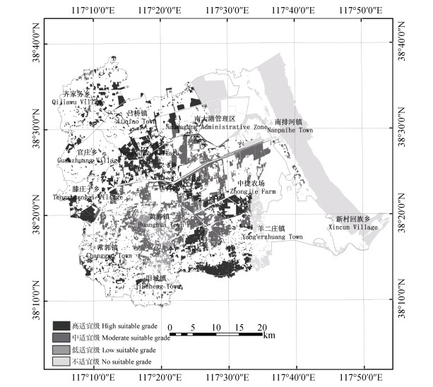
图1黄骅市未利用地资源宜耕性评价结果图
Figure1.Distribution of different grades of cultivation suitability of unused land in Huanghua City
 下载: 全尺寸图片幻灯片
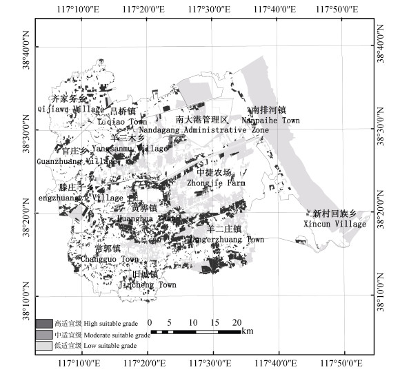
图2黄骅市未利用地资源宜建性评价结果图
Figure2.Distribution of different grades of construction suitability of unused land in Huanghua City
下载: 全尺寸图片幻灯片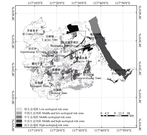
图3黄骅市未利用地资源生态风险评价结果图
Figure3.Distribution of different ecological risk zones of unused land in Huanghua City
下载: 全尺寸图片幻灯片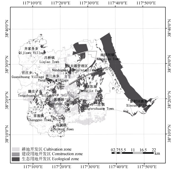
图4黄骅市未利用地开发分区图
Figure4.Distribution of exploitation zones of unused land in Huanghua City
下载: 全尺寸图片幻灯片表1未利用地3类利用类型的相对效益系数值
Table1.Relative efficiency coefficient values of three types of land use of unused land
| 未利用地利用类型 Utilization type of unused land | 经济效益系数 Coefficient of economic efficiency | 社会效益系数 Coefficient of social benefit | 生态效益系数 Eco-efficiency coefficient |
| 宜耕 Suitable for cultivation | 0.39 | 1.00 | 0.28 |
| 宜建 Suitable for construction | 1.00 | 0.51 | 0.03 |
| 宜生态 Suitable for ecology | 0.18 | 0.29 | 1.00 |
下载: 导出CSV表2盐碱地、其他草地宜耕评价指标体系
Table2.Cultivation suitability evaluation indexes system of saline-alkali soil and other grass land
| 分值 Score | 表土质地 Topsoil texture | 土体构型 Land structure | 地下水埋深 Groundwater depth (m) | 地下水开采限制 Groundwater mining limit | 地下水矿化度 Mineralization of groundwater (g·L-1) | 土壤含盐量 Soil salt content | 植被覆盖度 Vegetation coverage (%) |
| 100 | 壤土 Loam | 通体壤土, 壤土/砂土/壤土 Quintana loam, loam/silt/loam | > 10 | 无 No prohibition | 0~1 | 无盐化 No salinization | > 70 |
| 90 | 砂土 Silt | 壤土/砂土/砂土, 壤土/黏土/壤土 Loam/silt/silt, loam/clay/loam | 5~10 | ||||
| 80 | 砂土/黏土/砂土 Silt/clay/silt | 1~2 | 轻度 Light salinization | 50~70 | |||
| 70 | 黏土 Clay | 黏土/砂土/砂土, 通体砂土 Clay/silt/silt, quintana silt | |||||
| 60 | 黏土/砂土/黏土, 砂土/黏土/黏土 Loam/silt/clay, silt/clay/clay | 2~5 | 限制 Restriction | 中度 Moderate salinization | 30~50 | ||
| 50 | 通体黏土 Quintana stick | 2~5 | |||||
| 40 | 10~30 | ||||||
| 30 | 重度 Severe salinization | ||||||
| 20 | 0~10 | ||||||
| 10 | > 5 | ||||||
| 0 | 0~2 | 禁止 Prohibited | |||||
| 权重 Weight | 0.18 | 0.14 | 0.14 | 0.10 | 0.14 | 0.18 | 0.12 |
下载: 导出CSV表3内陆滩涂、沿海滩涂宜耕评价指标体系
Table3.Cultivation suitability evaluation indexes system of inland and coastal beaches
| 分值 Score | 表土质地 Topsoil texture | 地下水埋深 Groundwater depth (m) | 土体构型 Land structure | 周边土源类型 Surrounding soil source type | 土源距离 Soil source distance (m) |
| 100 | 壤土Loam | > 10 | 通体壤土, 壤土/砂土/壤土Quintana loam, loam/ silt/loam | 洪积物Diluvium | 0~500 |
| 90 | 砂土Sandy soil | 5~10 | 壤土/砂土/砂土, 壤土/黏土/壤土 Loam/silt/silt, loam/clay/loam | ||
| 80 | 砂土/黏土/砂土Silt/clay/ silt | 500~1000 | |||
| 70 | 黏土Clay | 黏土/砂土/砂土, 通体砂土Clay/silt/silt, quintana silt | |||
| 60 | 黏土/砂土/黏土, 砂土/黏土/黏土 Loam/silt/clay, silt/clay/clay | 黄土台 Loess platform | 1 000~2 000 | ||
| 50 | 2~5 | ||||
| 40 | 通体黏Quintana clay | ||||
| 30 | 2 000~3 000 | ||||
| 20 | > 3 000 | ||||
| 10 | |||||
| 0 | 0~2 | 无No soil source | |||
| 权重 Weight | 0.18 | 0.24 | 0.28 | 0.15 | 0.15 |
下载: 导出CSV表4未利用地宜建评价指标体系
Table4.Construction suitability evaluation indexes system of unutilized land
| 分值 Score | 地质灾害 Geological disaster | 地基承载力 Bearing capacity of foundation (kPa) | 淡水水源保障 Freshwater guarantee | 地下水埋深 Groundwater depth (m) | 距要道距离 Distance to artery (m) | 洪涝程度 Flood degree |
| 100 | 低易发区 Low-prone area | 充分满足 Sufficient satisfaction | > 3 | 0~500 | 标高高于设防洪水位≥1.0 m Elevation is 1.0 m above the flood control level. | |
| 90 | 满足 Satisfaction | |||||
| 80 | 坚硬 Hard | 500~1 000 | ||||
| 70 | 2~3 | 标高高于设防洪水位0~1.0 m Elevation is 0-1.0 m above the flood control level. | ||||
| 60 | 中易发区 Middle prone area | 较硬 Relatively hard | 1 000~1 500 | |||
| 50 | 基本满足 Basic satisfaction | |||||
| 40 | 较软 Relatively soft | 1~2 | 标高低于设防洪水位0~1.5 m Elevation is 0-1.5 m below the flood control level. | |||
| 30 | 1 500~2 000 | |||||
| 20 | 高易发区 High-prone area | 极软 Very soft | 缺乏 Lack | > 2 000 | ||
| 10 | < 1 | |||||
| 权重 Weight | 0.17 | 0.15 | 0.14 | 0.21 | 0.12 | 0.21 |
| ??地质灾害由《黄骅市地质灾害防治“十二五”规划分区图》矢量化获得; 地基承载力参考《河北省建筑地基承载力技术规程》DB(J)/T48—2005中关于不同物质构成确定对应承载力获得; 距要道距离反映了交通便利度。Geological disaster is the vectorization of “Zone Map of the Geological Disaster Control in the 12th Five-Year Plan of Huanghua City”; Bearing capacity of foundation refers to the bearing capacity of different materials in “Technical Regulations of Bearing Capacity of Foundation of Buildings in Hebei Province” DB(J)/T48—2005. Distance to main road shows traffic conveniences. | ||||||
下载: 导出CSV表5未利用土地开发生态风险评价指标体系
Table5.Ecological risk evaluation indexes system of utilization of unused land
| 盐渍程度 Salinity degree | 植被覆盖度 Vegetation coverage | 土层厚度 Soil thickness | 沥涝程度 Waterlogging degree | |||||||
| 分值 Score | 分级标准 Grading standard | 分值 Score | 分级标准 Grading standard | 分值 Score | 分级标准 Grading standard | 分值 Score | 分级标准 Grading standard | |||
| 20 | 轻度盐碱, 土壤含盐量 < 0.2% Light salinization with soil salt content less than 0.2% | 10 | > 70% | 20 | > 1 m | 20 | 降雨强度 > 30 mm·h-1, 排水体系健全, 降雨后有短期洪涝 Rainfall intensity is > 30 mm·h-1, or with perfect drainage system and short-term floods after rainfall | |||
| 40 | 中度盐碱, 土壤含盐量0.2%~0.4% Moderate salinization with 0.2%-0.4% soil salt content | 30 | 50%~70% | 40 | 0.6~1.0 m | 40 | 降雨强度为20-30 mm·h-1, 排水体系基本健全, 丰年大雨后田面积水2~3 d。 Rainfall intensity is 20-30 mm·h-1, or with basically perfect drainage system, and field ponding for 2-3 days after heavy rain in bumper harvest year | |||
| 60 | 重度盐碱, 土壤含盐量0.4%~0.6% Severe salinization with 0.4%-0.6% soil salt content | 50 | 30%~50% | 60 | 0.3~0.6 m | 60 | 降雨强度 < 20 mm·h-1, 基本无排水体系, 一般大雨后田面积水 > 3 d Rainfall intensity is lower than 20 mm·h-1, without drainage system, and field ponding for more than 3 days after heavy rain in general year | |||
| 80 | 盐土, 土壤含盐量 > 0.6% Saline soil with soil salt content above 0.6% | 70 | 10%~30% | 80 | < 0.3 m | 80 | ||||
| 90 | < 10% | |||||||||
| 权重 Weight | 0.3 | 0.25 | 0.2 | 0.25 | ||||||
下载: 导出CSV表6黄骅市各地类未利用地资源的宜耕性评价结果
Table6.Cultivation suitability of each type of unused land in Huanghua City
| 未利用地类型 Type of unused land | 高适宜级 High suitable grade | 中适宜级 Moderate suitable grade | 低适宜级 Low suitable grade | 不适宜级 No suitable grade | 总计 Total | |||||||||
| 面积 Area (hm2) | 比例 Proportion (%) | 面积 Area (hm2) | 比例 Proportion (%) | 面积 Area (hm2) | 比例 Proportion (%) | 面积 Area (hm2) | 比例 Proportion (%) | 面积 Area (hm2) | 比例 Proportion (%) | |||||
| 内陆滩涂 Inland beach | 4 306.79 | 19.10 | 0.00 | 0.00 | 2 504.34 | 43.16 | 0.00 | 0.00 | 6 811.13 | 10.23 | ||||
| 其他草地 Other grass land | 926.39 | 4.11 | 1 330.66 | 10.27 | 375.56 | 6.47 | 73.71 | 0.29 | 2 706.32 | 4.06 | ||||
| 沿海滩涂 Coastal beach | 0.00 | 0.00 | 0.00 | 0.00 | 0.00 | 0.00 | 22 997.43 | 90.97 | 22 997.43 | 34.54 | ||||
| 盐碱地 Saline land | 17 319.16 | 76.80 | 11 624.76 | 89.73 | 2 921.92 | 50.36 | 2 209.81 | 8.74 | 34 075.65 | 51.17 | ||||
| 总计Total | 22 552.34 | 100.00 | 12 955.43 | 100.00 | 5 801.81 | 100.00 | 25 280.95 | 100.00 | 66 590.53 | 100.00 | ||||
下载: 导出CSV表7黄骅市各地类未利用地资源类型宜建评价结果
Table7.Construction suitability of each type of unused land in Huanghua City
| 未利用地类型 Type of unused land | 高适宜级 High suitable grade | 中适宜级 Moderate suitable grade | 低适宜级 Low suitable grade | 总计 Total | |||||||
| 面积 Area (hm2) | 比例 Proportion (%) | 面积 Area (hm2) | 比例 Proportion (%) | 面积 Area (hm2) | 比例 Proportion (%) | 面积 Area (hm2) | 比例 Proportion (%) | ||||
| 内陆滩涂 Inland beach | 0.00 | 0.00 | 0.00 | 0.00 | 6 811.13 | 14.16 | 6 811.13 | 10.23 | |||
| 其他草地 Other grass land | 0.00 | 0.00 | 192.01 | 39.35 | 2 514.31 | 5.23 | 2 706.32 | 4.06 | |||
| 沿海滩涂 Coastal beach | 0.00 | 0.00 | 0.00 | 0.00 | 22 997.43 | 47.80 | 22 997.43 | 34.54 | |||
| 盐碱地 Saline land | 17 996.17 | 100.00 | 295.94 | 60.65 | 15 783.54 | 32.81 | 34 075.65 | 51.17 | |||
| 总计Total | 17 996.17 | 100.00 | 487.95 | 100.00 | 48 106.41 | 100.00 | 66 590.53 | 100.00 | |||
下载: 导出CSV表8黄骅市各地类未利用地资源生态风险评价结果
Table8.Ecological risk of each type of unused land in Huanghua City
| 未利用地类型 Type of unused land | 低生态风险区 Low ecological risk zone | 中低生态风险区 Middle and low ecological risk zone | 中生态风险区 Middle ecological risk zone | 中高生态风险区 Middle and high ecological risk zone | 高生态风险区 High ecological risk zone | |||||||||
| 面积 Area (hm2) | 比例 Proportion (%) | 面积 Area (hm2) | 比例 Proportion (%) | 面积 Area (hm2) | 比例 Proportion (%) | 面积 Area (hm2) | 比例 Proportion (%) | 面积 Area (hm2) | 比例 Proportion (%) | |||||
| 内陆滩涂 Inland beach | 0.00 | 0.00 | 1 001.25 | 4.90 | 2 482.63 | 19.41 | 2 468.42 | 13.27 | 858.83 | 67.98 | ||||
| 其他草地 Other grass land | 525.29 | 3.89 | 1 304.48 | 6.38 | 876.55 | 6.85 | 0.00 | 0.00 | 0.00 | 0.00 | ||||
| 沿海滩涂 Coastal beach | 0.00 | 0.00 | 0.00 | 0.00 | 7 305.36 | 57.11 | 15 287.57 | 82.20 | 404.50 | 32.02 | ||||
| 盐碱地 Saline land | 12 980.65 | 96.11 | 18 127.00 | 88.72 | 2 126.63 | 16.63 | 841.38 | 4.52 | 0.00 | 0.00 | ||||
| 总计Total | 13 505.94 | 100.00 | 20 432.73 | 100.00 | 12 791.17 | 100.00 | 18 597.37 | 100.00 | 1 263.33 | 100.00 | ||||
下载: 导出CSV表9黄骅市各乡镇未利用地开发分区结果
Table9.Regionalization results of exploitation of unused land in Huanghua City
| hm2 | |||
| 乡镇 Town | 耕地开发区 Cultivation zone | 建设用地开发区 Construction zone | 生态用地开发区 Ecological zone |
| 常郭镇 Changguo Town | 936.29 | 0.00 | 853.89 |
| 官庄乡 Guanzhuang Village | 429.77 | 0.00 | 87.97 |
| 中捷农场 Zhongjie Farm | 2 902.78 | 150.39 | 4 345.19 |
| 黄骅镇 Huanghua Town | 811.32 | 2 439.96 | 834.42 |
| 旧城镇 Jiucheng Town | 1 400.46 | 20.58 | 1 236.79 |
| 吕桥镇 Lüqiao Town | 900.00 | 0.00 | 3 310.40 |
| 南大港管理区 Nandagang Administrative Zone | 2 225.04 | 491.06 | 3 522.01 |
| 南排河镇 Nanpaihe Town | 148.68 | 200.93 | 15 986.46 |
| 齐家务乡 Qijiawu Village | 1 223.95 | 131.33 | 456.43 |
| 滕庄子乡 Tengzhuangzi Village | 2 260.43 | 144.71 | 2 017.85 |
| 新村回族乡 Xincun Village | 0.00 | 0.00 | 8 030.46 |
| 羊二庄镇 Yang’erzhuang Town | 3 830.44 | 0.00 | 2 535.17 |
| 羊三木乡 Yangsanmu Village | 2 036.43 | 0.00 | 688.94 |
下载: 导出CSV参考文献
| [1] | WEI Y D, YE X Y. Urbanization, urban land expansion and environmental change in China[J]. Stochastic Environmental Research and Risk Assessment, 2014, 28(4):757-765 doi: 10.1007/s00477-013-0840-9 |
| [2] | LONG H L, ZOU J, LIU Y S. Differentiation of rural development driven by industrialization and urbanization in eastern coastal China[J]. Habitat International, 2009, 33(4):454-462 doi: 10.1016/j.habitatint.2009.03.003 |
| [3] | 陈百明, 张凤荣.我国土地利用研究的发展态势与重点领域[J].地理研究, 2011, 30(1):1-9 http://www.cqvip.com/QK/95732X/201101/36403507.html CHEN B M, ZHANG F R. Trend and priority areas in land use research of China[J]. Geographical Research, 2011, 30(1):1-9 http://www.cqvip.com/QK/95732X/201101/36403507.html |
| [4] | 韦仕川, 吴次芳, 杨杨.黄河三角洲未利用地适宜性评价的资源开发模式——以山东省东营市为例[J].中国土地科学, 2013, 27(1):55-60 http://www.cqvip.com/QK/96793X/201301/44777659.html WEI S C, WU C F, YANG Y. The land development models in Yellow River Delta:Based on land suitability evaluation for unutilized land resources[J]. China Land Sciences, 2013, 27(1):55-60 http://www.cqvip.com/QK/96793X/201301/44777659.html |
| [5] | 党丽娟, 徐勇, 汤青, 等.广西西江沿岸后备适宜建设用地潜力及空间分布[J].自然资源学报, 2014, 29(3):387-397 doi: 10.11849/zrzyxb.2014.03.003 DANG L J, XU Y, TANG Q, et al. Potential and spatial dis-tribution of suitable construction land along the Xijiang riv-erside in Guangxi[J]. Journal of Natural Resources, 2014, 29(3):387-397 doi: 10.11849/zrzyxb.2014.03.003 |
| [6] | 魏海, 秦博, 彭建, 等.基于GRNN模型与邻域计算的低丘缓坡综合开发适宜性评价——以乌蒙山集中连片特殊困难片区为例[J].地理研究, 2014, 33(5):831-841 doi: 10.11821/dlyj201405003 WEI H, QIN B, PENG J, et al. Evaluation on comprehensive exploitation suitability of low-slope hilly land based on GRNN model and neighborhood calculation:A case study of Wumeng Mountain continuous poverty-stricken region[J]. Geographical Research, 2014, 33(5):831-841 doi: 10.11821/dlyj201405003 |
| [7] | 唐常春, 孙威.长江流域国土空间开发适宜性综合评价[J].地理学报, 2012, 67(12):1587-1598 doi: 10.11821/xb201212001 TANG C C, SUN W. Comprehensive evaluation of land spa-tial development suitability of the Yangtze River Basin[J]. Acta Geographica Sinica, 2012, 67(12):1587-1598 doi: 10.11821/xb201212001 |
| [8] | 李猷, 王仰麟, 彭建, 等.基于景观生态的城市土地开发适宜性评价——以丹东市为例[J].生态学报, 2010, 30(8):2141-2150 http://www.wanfangdata.com.cn/details/detail.do?_type=perio&id=stxb201008023 LI Y, WANG Y L, PENG J, et al. Assessment of urban land suitability for construction in view of landscape ecology:A case study of Dandong City[J]. Acta Ecologica Sinica, 2010, 30(8):2141-2150 http://www.wanfangdata.com.cn/details/detail.do?_type=perio&id=stxb201008023 |
| [9] | 类淑霞, 郝晋珉, 王丽敏.生态脆弱区宜耕未利用土地开发适宜性评价——以山西省大同市为例[J].中国生态农业学报, 2011, 19(6):1417-1423 http://www.ecoagri.ac.cn/zgstny/ch/reader/view_abstract.aspx?file_no=20110631&flag=1 LEI S X, HAO J M, WANG L M. Evaluation of exploitation suitability of unutilized arable lands in ecologically fragile areas-A case study of Datong City, Shanxi Province[J]. Chinese Journal of Eco-Agriculture, 2011, 19(6):1417-1423 http://www.ecoagri.ac.cn/zgstny/ch/reader/view_abstract.aspx?file_no=20110631&flag=1 |
| [10] | 韦仕川, 刘勇, 栾乔林, 等.基于生态安全的黄河三角洲未利用地开垦潜力评价[J].农业工程学报, 2013, 29(22):244-251 doi: 10.3969/j.issn.1002-6819.2013.22.029 WEI S C, LIU Y, LUAN Q L, et al. Evaluation on reclamation potential of unused land of the Yellow River Delta based on ecological security[J]. Transactions of the CSAE, 2013, 29(22):244-251 doi: 10.3969/j.issn.1002-6819.2013.22.029 |
| [11] | PEREIRA J M C, DUCKSTEIN L. A multiple criteria deci-sion-making approach to GIS-based land suitability evalua-tion[J]. International Journal of Geographical Information Systems, 1993, 7(5):407-424 doi: 10.1080/02693799308901971 |
| [12] | FITZSIMONS J, PEARSON C J, LAWSON C, et al. Evalua-tion of land-use planning in greenbelts based on intrinsic characteristics and stakeholder values[J]. Landscape and Urban Planning, 2012, 106(1):23-34 doi: 10.1016/j.landurbplan.2012.01.012 |
| [13] | AFSHARI M, MAFI E. Land capability assessment for re-gional planning using AHP and GIS at Shandiz Urban Region, Northeast Iran[J]. Environment and Urbanization ASIA, 2014, 5(1):105-118 doi: 10.1177/0975425314521537 |
| [14] | 金贵, 王占岐, 胡学东, 等.基于模糊证据权模型的青藏高原区土地适宜性评价[J].农业工程学报, 2013, 29(18):241-250 doi: 10.3969/j.issn.1002-6819.2013.18.029 JIN G, WANG Z Q, HU X D, et al. Land suitability evalua-tion in Qinghai-Tibet Plateau based on fuzzy weight of evi-dence model[J]. Transactions of the CSAE, 2013, 29(18):241-250 doi: 10.3969/j.issn.1002-6819.2013.18.029 |
| [15] | 张凤荣, 郭力娜, 关小克, 等.生态安全观下耕地后备资源评价指标体系探讨[J].中国土地科学, 2009, 23(9):4-8 http://www.doc88.com/p-167100892752.html ZHANG F R, GUO L N, GUAN X K, et al. Study on the evaluation indicators of the arable land from the view of ecological security[J]. China Land Science, 2009, 23(9):4-8 http://www.doc88.com/p-167100892752.html |
| [16] | 舒帮荣, 黄琪, 刘友兆, 等.基于变权的城镇用地扩展生态适宜性空间模糊评价——以江苏省太仓市为例[J].自然资源学报, 2012, 27(3):402-412 doi: 10.11849/zrzyxb.2012.03.006 SHU B R, HUANG Q, LIU Y Z, et al. Spatial fuzzy assess-ment of ecological suitability for urban land expansion based on variable weights:A case study of Taicang[J]. Journal of Natural Resources, 2012, 27(3):402-412 doi: 10.11849/zrzyxb.2012.03.006 |
| [17] | 吴大放, 刘艳艳, 刘毅华, 等.耕地生态安全评价研究展望[J].中国生态农业学报, 2015, 23(3):257-267 http://www.ecoagri.ac.cn/zgstny/ch/reader/view_abstract.aspx?file_no=2015301&flag=1 WU D F, LIU Y Y, LIU Y H, et al. Progress on ecological security evaluation of cultivated land[J]. Chinese Journal of Eco-Agriculture, 2015, 23(3):257-267 http://www.ecoagri.ac.cn/zgstny/ch/reader/view_abstract.aspx?file_no=2015301&flag=1 |
| [18] | 关小克, 张凤荣, 郭力娜, 等.北京市耕地多目标适宜性评价及空间布局研究[J].资源科学, 2010, 32(3):580-587 http://www.oalib.com/paper/4414290 GUAN X K, ZHANG F R, GUO L N, et al. A suitability evaluation of cultivated land in Beijing for multi-purposes use and its spatio-temporal investigation[J]. Resources Science, 2010, 32(3):580-587 http://www.oalib.com/paper/4414290 |
| [19] | 廖和平.未利用地适宜性评价方法研究——以攀枝花市仁和区为例[J].西南师范大学学报:自然科学版, 1997, 22(2):199-205 http://kns.cnki.net/KCMS/detail/detail.aspx?filename=xnzk702.015&dbname=CJFD&dbcode=CJFQ LIAO H P. Research on the method of suitability evaluation of the unutilized land-Example for Renhe County, Panzhihua City[J]. Journal of Southwest China Normal University:Natural Science, 1997, 22(2):199-205 http://kns.cnki.net/KCMS/detail/detail.aspx?filename=xnzk702.015&dbname=CJFD&dbcode=CJFQ |
| [20] | 刘耀林, 焦利民.基于计算智能的土地适宜性评价模型[J].武汉大学学报:信息科学版, 2005, 30(4):283-287 http://www.oalib.com/paper/5218241 LIU Y L, JIAO L M. Model of land suitability evaluation based on computational intelligence[J]. Geomatics and In-formation Science of Wuhan University, 2005, 30(4):283-287 http://www.oalib.com/paper/5218241 |
| [21] | 欧阳志云, 王如松, 符贵南.生态位适宜度模型及其在土地利用适宜性评价中的应用[J].生态学报, 1996, 16(2):113-120 https://www.wenkuxiazai.com/doc/6fd85ac1b9d528ea81c779dc.html OUYANG Z Y, WANG R S, FU G N. Ecological niche suita-bility model and its application in land suitability assess-ment[J]. Acta Ecologica Sinica, 1996, 16(2):113-120 https://www.wenkuxiazai.com/doc/6fd85ac1b9d528ea81c779dc.html |
| [22] | 袁磊, 赵俊三, 李红波, 等.云南山区宜耕未利用地开发适宜性评价与潜力分区[J].农业工程学报, 2013, 29(16):229-237 doi: 10.3969/j.issn.1002-6819.2013.16.029 YUAN L, ZHAO J S, LI H B, et al. Exploitation suitability evaluation and potential area zoning for arable unused land in mountainous areas of Yunnan Province[J]. Transactions of the CSAE, 2013, 29(16):229-237 doi: 10.3969/j.issn.1002-6819.2013.16.029 |
| [23] | 武启祥, 杨永芳, 朱连奇.县域土地利用结构与效益的权衡[J].经济地理, 2013, 33(8):147-152 http://www.cqvip.com/QK/93124X/201308/47169593.html WU Q X, YANG Y F, ZHU L Q. Trade-off between structure and efficiency of land use in county scale[J]. Economic Geography, 2013, 33(8):147-152 http://www.cqvip.com/QK/93124X/201308/47169593.html |
| [24] | 王华, 刘耀林, 姬盈利.基于多目标微粒群优化算法的土地利用分区模型[J].农业工程学报, 2012, 28(12):237-244 doi: 10.3969/j.issn.1002-6819.2012.12.038 WANG H, LIU Y L, JI Y L. Land use zoning model based on multi-objective particle swami optimization algorithm[J]. Transactions of the CSAE, 2012, 28(12):237-244 doi: 10.3969/j.issn.1002-6819.2012.12.038 |
| [25] | DUH J D, BROWN D G. Knowledge-informed Pareto simulated annealing for multi-objective spatial allocation[J]. Computers, Environment and Urban Systems, 2007, 31(3):253-281 doi: 10.1016/j.compenvurbsys.2006.08.002 |
| [26] | CAO K, BATTY M, HUANG B, et al. Spatial mul-ti-objective land use optimization:Extensions to the non-dominated sorting genetic algorithm-Ⅱ[J]. International Journal of Geographical Information Science, 2011, 25(12):1949-1969 doi: 10.1080/13658816.2011.570269 |
