 ,内蒙古师范大学地理科学学院,呼和浩特 010022
Characteristics of grassland utilization in Mongolian Plateauand their differences among countries
WULAN Tuya,College of Geographical Sciences, Inner Mongolia Normal University, Hohhot 010022, China收稿日期:2020-02-24修回日期:2020-12-11网络出版日期:2021-07-25
| 基金资助: |
Received:2020-02-24Revised:2020-12-11Online:2021-07-25
| Fund supported: |
作者简介 About authors
乌兰图雅(1967-), 女, 内蒙古库伦旗人, 博士, 教授, 主要从事土地利用与生态安全研究。E-mail:

摘要
关键词:
Abstract
Keywords:
PDF (1792KB)元数据多维度评价相关文章导出EndNote|Ris|Bibtex收藏本文
本文引用格式
乌兰图雅. 蒙古高原草地利用特征及其国别差异. 地理学报[J], 2021, 76(7): 1722-1731 doi:10.11821/dlxb202107011
WULAN Tuya.
土地利用是指人类为获取所需的产品或服务,而对土地自然属性利用的目的、方式、手段和意图。1995年“土地利用/覆被变化科学研究计划”(LUCC)的提出[1],2005年发布“全球土地计划”(Global Land Project, GLP)[2],2012年发布“未来地球”(Future Earth)研究计划,土地利用/覆被变化始终是全球变化研究的核心内容[3,4,5],“土地利用变化与生态系统服务”是当前国际地理学界关注的前沿问题之一[6,7]。
蒙古高原位于亚洲内陆地区,东起大兴安岭、西至阿尔泰山脉,北起肯特山—雅布洛诺夫山脉、南至阴山山脉,主要包括蒙古国全部及中国内蒙古自治区全境[8]。高原西部为海拔3000~3500 m的高山,南部为广阔的戈壁,中部和东部为平均海拔700~1400 m的高平原区,整体地势东低西高。高原属于温带大陆性气候区,夏季温热、冬季寒冷,年温差大,降水主要集中在夏季,在高原北部的色楞格河流域、东南部的大兴安岭西麓均可达400 mm左右,然后向南、向西逐渐减少,至中蒙交界处的二连浩特市仅为100 mm左右,形成了从高原北部、东部的半湿润地带依次向西、向南过渡到半干旱、干旱和极干旱的半环绕带状气候格局。与气候条件相呼应,蒙古高原的植被、土壤也有明显的带状特征,植被类型由北向南、由东向西依次为草甸草原、典型草原、荒漠草原、戈壁荒漠,土壤类型依次为黑钙土、栗钙土、棕钙土和灰棕漠土。
典型的温带干旱、半干旱气候孕育了蒙古高原广阔的草原带,草地是高原主要自然景观。其中,典型草原主要分布于蒙古国东部的苏赫巴托、肯特和东方3个省,以及中国内蒙古锡林郭勒盟东部、呼伦贝尔市西部,是温带草原的核心组成。内蒙古草原是这一草原带的南部组成部分,是中国主要的畜牧业基地之一,更是中国北方重要的生态屏障。在这草原带,边境线内外自然条件相同,干旱、多灾、脆弱特征一致,畜牧业经济核心地位相似,同属于游牧文明的发源地。同时,由于草原分布面积之广、利用强度之大,草地沙漠化、植被退化等问题日益严重[9,10,11,12],威胁着中国北部边疆的生态安全、社会稳定与经济发展[13,14]。尤其自20世纪80年代初中国内蒙古实施草场承包制以来,草地利用逐步由游牧转为定牧,直至今天的禁牧、休牧、轮牧,与蒙古国的传统游牧形成鲜明对比,使得同一草原带所受压力不同、影响因素各异,导致草地利用的方式和强度、草场退化的类型和程度差异更为显著。为此,近年来有关蒙古高原地学研究中[15,16,17,18,19,20,21],草原植被一直是研究的热点[22,23,24,25,26,27,28],作为人类干扰的最直接表现,草原土地利用变化信息也零星出现于蒙古高原土地利用变化相关研究中[29,30,31,32],但围绕草原开展的土地利用专门研究以及国别差异分析相对少见。鉴于此,本文选取蒙古高原典型草原跨境样带,借助遥感调查与实地踏查方法,系统分析了蒙古高原草地利用的现状特征、变化趋势以及国别差异,力求揭示草地变化特点及其主要人为干扰因素,为中国草原生态建设探寻有效的修复途径和可借鉴的经验。
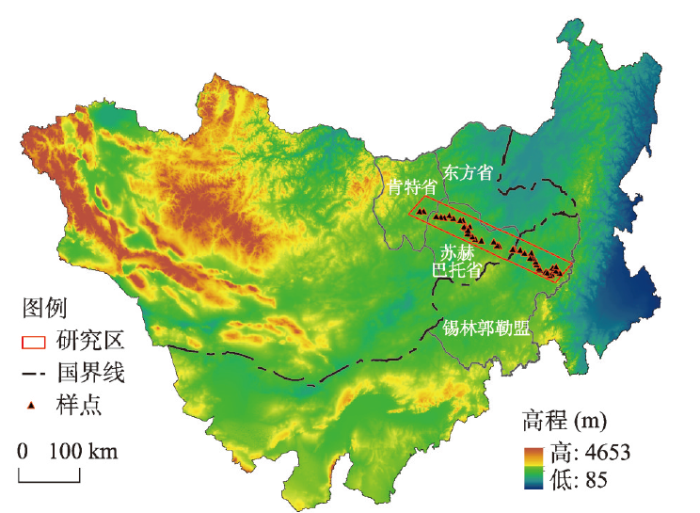
1 样带划定
基于典型草原—栗钙土作业区的统一背景,样带的划定首先考虑下垫面自然地理条件的均质性,侧重于选择地形平坦的高平原区。同时,兼顾样带穿越不同国家领地,以便全面展示同一草原在不同国家、不同利用方式、不同利用强度下的变化特征。研究样带位于蒙古高原典型草原核心区,由西北部的蒙古国肯特省温都尔汗市向东南延伸至中国内蒙古西乌珠穆沁旗巴彦花镇,4个控制点分别为(111°8′51.25″E, 47°56′20.13″N)(西北)、(119°13′25.31″E, 45°13′9.35″N)(东北)、(118°14′32.64″E, 44°32′30.80″N)(东南)、(110°13′34.08″E, 47°13′58.02″N)(西南),斜跨蒙古国肯特省、苏赫巴托省、东方省和中国内蒙古锡林郭勒盟,总面积为6.985万km2(图1)。样带内,蒙古国段面积占比66.73%,中国内蒙古段面积占比33.27%。图1
 新窗口打开|下载原图ZIP|生成PPT
图1蒙古高原典型草原乌珠穆沁—温都尔汗样带区位
注:基于国家测绘地理信息局标准地图服务网站下载的审图号为GS(2016)1600号的标准地图制作,底图无修改。
Fig. 1Location of Ujimqin-Undur Khan sample belt of typical steppe in Mongolian Plateau
2 数据与方法
数据选择上,本文力求选取降水和气温接近多年平均值年份的遥感影像,以客观反映样带植被的正常表现;同时考虑中国土地承包责任制的实施时间和蒙古国社会经济体制的变革时间,以20世纪80年代末期为起始年份,采用相同时间间隔的影像数据为主要信息源。基于上述两点,结合成像质量,研究从美国地质勘探局(USGS)获取1988年、1995年、2002年、2009年、2016年(7—8月份)5期分辨率为30 m的landsat-TM影像作为信息源,对样带2016年的土地利用状况及其1988-2016年的变化进行了分析。遥感影像解译工作的前提是土地利用类型的划分。根据草原样带无林地的实际情况,并依据《全国土地利用分类系统(GB/T21010-2007)》和蒙古国土地利用分类体系[33],将样带土地利用划分为耕地、草地、水域、城镇及工矿用地、未利用土地等5个一级类型。其中,城镇及工矿用地划分为居民地、工矿用地2个亚类,未利用土地划分为盐碱地、沙地和沼泽地等3个亚类。
土地利用信息的提取,首先解译2016年土地利用现状,并于2016年和2017年的7—8月各利用15~20 d时间对境内外的样地进行实地踏查,核准了解译结果(图1)。之后,把样带2016年土地利用现状与其他4期影像解译结果进行叠加,再以国境线为界进行分割,获得1988—2016年样带的土地利用变化及其国别信息。
3 结果与分析
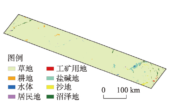
3.1 2016年样带土地利用状况
解译样带2016年遥感影像,获得当年土地利用信息。样带土地利用类型中,草地占比最大,为95.05%,因此样带土地利用可称为“草地利用”;在其余不足5%的用地类型中,占比1%左右的有盐碱地、沼泽地和沙地等未利用土地,占比分别为1.86%、1.20%和0.9%;接近0.5%的有耕地和水域,占比为0.41%和0.35%;居民地和工矿用地占比仅为0.08%和0.15%。在空间分布上,草地铺满整个样带以外,其他地类较为集中(图2)。其中,耕地主要分布于样带西北部;盐碱地、沼泽地、沙地和工矿用地主要分布于样带东南部;水域、居民地零星分布于整个样带。
图2
 新窗口打开|下载原图ZIP|生成PPT
图22016年样带土地利用类型分布
Fig. 2Distribution of land use types of sample belt in 2016
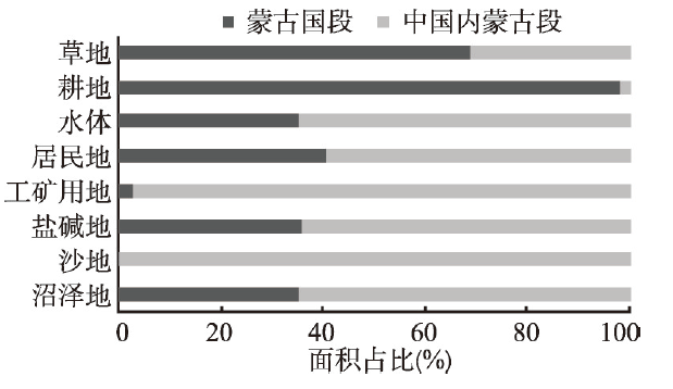
2016年地类分布国别特征显著,与样带不尽相同。蒙古国段草地占该段总面积的97.96%,占样带草地总面积的68.84%;中国内蒙古段草地占该段总面积的89.20%,占样带草地总面积的31.16%,均体现草地下垫面的优势。但是,其他地类面积占比的国别差异较大,表明除放牧活动外,样带其他人文经济活动的国别差异显著(图3)。主要体现在以下3点:① 蒙古国段耕地占该段总面积的0.61%,占样带耕地总面积的97.91%,集中分布于样带蒙古国段西北部,表明垦殖是蒙古国草地质变的主要人为因素;② 内蒙古段工矿用地占该段总面积的0.43%,占样带工矿用地总面积的97.20%,表明矿产开采是内蒙古草地质变主要人文因素;③ 内蒙古段沙地占该段总面积的4.50%,占样带沙地总面积的99.88%,表明内蒙古土地沙漠化严重且范围广泛;④ 样带64.69%的盐碱地和65.03%的沼泽地也分布于内蒙古段,表明内蒙古草地退化范围广泛且类型多样;⑤ 基于河流等主要地表水资源的空间分布,样带内蒙古段的水域面积大于样带蒙古国段。
图3
 新窗口打开|下载原图ZIP|生成PPT
图3样带国别地类面积占比
Fig. 3Land types proportion of sample belt in different countries
3.2 样带土地利用变化幅度
1988—2016年样带土地利用变化幅度如表1所示。样带草地面积一直在减少,虽然减幅仅为1.8%,但是草地占比大,因此实际缩减面积不可忽视;沙地、工矿用地、盐碱地的面积均在波动式增加,增幅分别于1988—1995年、1995—2002年、2002—2009年达到最大值;耕地、水域面积波动式减少。总体来看,1988—2016年样带草地、耕地、水域面积在减少,其中耕地减幅最大,为35.71%;工矿用地、盐碱地、沙地、居民地面积逐年增加,其中工矿用地增幅最为突出,为初期的近367倍。Tab. 1
表1
表11988—2016年样带土地利用变化幅度(%)
Tab. 1
| 土地利用类型 | 1988—1995年 | 1995—2002年 | 2002—2009年 | 2009—2016年 | 1988—2016年 |
|---|---|---|---|---|---|
| 草地 | -0.67 | -0.19 | -0.21 | -0.73 | -1.80 |
| 耕地 | -9.75 | -14.18 | -31.06 | 20.40 | -35.71 |
| 水域 | 21.45 | 32.59 | -45.27 | -2.91 | -14.43 |
| 居民地 | 17.30 | 24.45 | 33.06 | 67.98 | 226.28 |
| 工矿用地 | 7.12 | 1005.29 | 790.83 | 248.80 | 36690.50 |
| 盐碱地 | 28.88 | 17.49 | 52.63 | 18.93 | 174.88 |
| 沙地 | 71.72 | 18.64 | 26.82 | 20.40 | 211.07 |
| 沼泽地 | 18.90 | -10.99 | -7.19 | 4.81 | 2.94 |
新窗口打开|下载CSV
样带蒙古国段土地利用变化幅度如表2所示。样带蒙古国段草地面积微有波动,总面积减少0.06%;耕地面积在2009—2016年稍有增加以外,其他时期均在缩减,总体减少36.93%;水域面积在2002—2009年有所增加以外,其他时期均缩减;工矿用地面积持续递增,在2002—2009年达到最大值,增幅为75.29%;未利用土地中盐碱地持续增加、沙地和沼泽地波动式增加。
Tab. 2
表2
表21988—2016年样带蒙古国段土地利用变化幅度(%)
Tab. 2
| 土地利用类型 | 1988—1995年 | 1995—2002年 | 2002—2009年 | 2009—2016年 | 1988—2016年 |
|---|---|---|---|---|---|
| 草地 | -0.08 | 0.01 | 0.08 | -0.07 | -0.06 |
| 耕地 | -12.35 | -12.79 | -31.19 | 19.90 | -36.93 |
| 水域 | -9.45 | -7.50 | 20.61 | -23.61 | -22.83 |
| 居民地 | 18.19 | 21.78 | 7.97 | 48.91 | 131.42 |
| 工矿用地 | 1.19 | 49.19 | 75.29 | 10.40 | 192.13 |
| 盐碱地 | 47.75 | 15.44 | 29.33 | 12.51 | 148.18 |
| 沙地 | -60.77 | 143.20 | 189.42 | 52.95 | 322.37 |
| 沼泽地 | 22.96 | 8.71 | -1.43 | -6.85 | 22.74 |
新窗口打开|下载CSV
样带中国内蒙古段土地利用变化幅度如表3所示。样带中国内蒙古段草地面积缓慢递减,减幅为5.42%,大于蒙古国段;耕地波动式增加,增幅为初期的3倍多;水域和沼泽地面积略有缩减;居民地、盐碱地和沙地面积持续增加;工矿用地面积增幅最大,在2002—2009年增幅高达1457.73%。
Tab. 3
表3
表31988—2016年样带中国内蒙古段土地利用变化幅度(%)
Tab. 3
| 土地利用类型 | 1988—1995年 | 1995—2002年 | 2002—2009年 | 2009—2016年 | 1988—2016年 |
|---|---|---|---|---|---|
| 草地 | -1.91 | -0.63 | -0.83 | -2.16 | -5.42 |
| 耕地 | 755.06 | -55.95 | -23.15 | 47.00 | 325.51 |
| 水域 | 44.50 | 51.34 | -64.09 | 16.96 | -8.15 |
| 居民地 | 16.13 | 28.03 | 65.08 | 83.89 | 351.34 |
| 工矿用地 | -15.38 | 624.23 | 1457.73 | 273.81 | 35585.15 |
| 盐碱地 | 23.70 | 18.17 | 60.10 | 20.59 | 182.22 |
| 沙地 | 71.85 | 18.61 | 26.74 | 20.37 | 210.95 |
| 沼泽地 | 17.21 | -19.61 | -10.59 | 12.41 | -5.30 |
新窗口打开|下载CSV
总体来看,1988—2016年样带蒙古国段和中国内蒙古段草地和水域面积均减少,工矿用地和未利用土地面积均增加,表明境内外干旱化趋势一致,草地退化普遍。但是,从变化幅度来看,中国内蒙古段居民地、工矿用地的增幅和草地减幅均大于蒙古国段,表明内蒙古草地的人类影响远大于蒙古国。
3.3 样带土地利用变化方向
1988—2016年样带土地利用变化方向如表4所示。① 草地转换类型多,涵盖了其他所有用地类型,其中转向盐碱地、沙地和沼泽地的草地面积占总转换面积的88.1%,表明草地退化程度严重、类型多样;② 耕地主要与草地互转,其中耕地转出以弃耕或退耕为主;③ 水域面积缩小,其中65.2%的水域转向盐碱地、沼泽地等未利用土地,表明地表水域干涸、缩减明显;④ 居民地、工矿用地为净增加类型,均以草地转入为主;⑤ 未利用土地以草地转入为主,其中沼泽地的93.5%也转向了草地、盐碱地、沙地,再次表明样带自然环境干旱化趋势显著。Tab. 4
表4
表41988—2016年样带土地利用转移矩阵(km2)
Tab. 4
| 土地利用类型 | 草地 | 耕地 | 水体 | 居民地 | 工矿用地 | 盐碱地 | 沙地 | 沼泽地 | 1988年 |
|---|---|---|---|---|---|---|---|---|---|
| 草地 | 12.30 | 45.64 | 39.49 | 93.13 | 794.61 | 420.36 | 189.41 | 1594.94 | |
| 耕地 | 173.78 | 0.03 | 173.81 | ||||||
| 水体 | 35.07 | 42.10 | 2.73 | 21.86 | 101.76 | ||||
| 居民地 | 0.00 | ||||||||
| 工矿用地 | 0.16 | 0.12 | 0.28 | ||||||
| 盐碱地 | 10.02 | 8.95 | 0.06 | 1.31 | 2.34 | 22.67 | |||
| 沙地 | 7.55 | 2.76 | 0.43 | 1.66 | 12.39 | ||||
| 沼泽地 | 153.20 | 0.72 | 5.52 | 0.14 | 6.14 | 11.25 | 14.29 | 191.26 | |
| 2016年 | 379.78 | 13.02 | 60.23 | 39.63 | 102.09 | 848.41 | 438.68 | 215.27 | 2097.11 |
新窗口打开|下载CSV
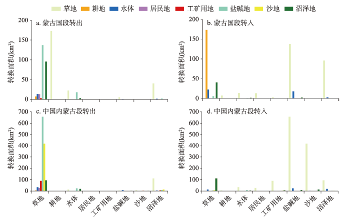
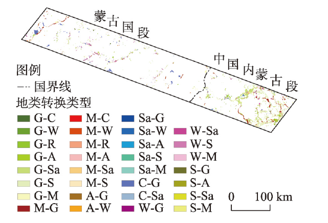
样带土地利用类型转换在2个国家既有共性,也有差异(图4)。共性表现为境内外草地、水域面积均减少,并主要转向盐碱地和沙地。差异表现在以下3个方面:① 耕地在蒙古国段以净转出为主,且多转为草地;在内蒙古段耕地占比不大,但是主要转向未利用土地;② 工矿用地以草地转入为主,集中于内蒙古段;③ 未利用土地的所有亚类面积大幅增加,其中蒙古国段以盐碱地和沼泽地增加为主,主要由草地和水域转入;而内蒙古段盐碱地和沙地面积增幅更大,主要由草地转入,表明草地退化在内蒙古段尤为严重。
图4
 新窗口打开|下载原图ZIP|生成PPT
图4样带国别地类转换面积
Fig. 4Land type transition area of sample belt in different countries
3.4 样带土地利用变化区域
样带土地利用类型变化及其分布情况如图5所示。蒙古国段土地利用类型转换面积较小且分布不均衡,该段最主要特征是耕地转向草地,转出部分在西北部克鲁伦河流域相对集中,在东南部的苏赫巴托省零星分布;中国内蒙古段土地利用类型转换面积较大且分布相对集中,该段最主要特征是草地的转出,其中在东南部的西乌珠穆沁旗转向工矿用地较多,在中部及南部区域主要转向沙地。图5
 新窗口打开|下载原图ZIP|生成PPT
图5样带国别地类转换分布
注:G=草地;C=耕地;W=水域;R=居民地;A=工矿用地;Sa=盐碱地;S=沙地;M=沼泽地
Fig. 5Distribution of land type transition in different countries
4 结论与讨论
4.1 结论
(1)从2016年样带草地利用情况来看,草地占绝对优势,为95.05%,在境内外占比接近;其他地类占比均较小,但分布相对集中,97.91%的耕地集中于样带西北部的蒙古国段,97.20%的工矿用地、99.88%的沙地、64.43%的盐碱地、65.03%的沼泽地分布于样带东南部的内蒙古段。(2)1988—2016年样带草地、耕地、水域面积在减少,其中耕地减幅最大,为35.71%,集中于样带西北部的蒙古国段;工矿用地、盐碱地、沙地、居民地面积逐年增加,其中工矿用地增幅最大,为初期的近367倍,集中于样带东南部的内蒙古段。
(3)1988—2016年样带蒙古国段和内蒙古段草地、水域面积均减少,并主要转为未利用土地,其中内蒙古段草地减幅为5.42%,大于蒙古国段的0.06%,表明内蒙古草地退化相对严重;工矿用地、未利用土地均增加,均由草地转入,其中内蒙古工矿用地增幅约为初期的356倍,远大于蒙古国的1.92倍,表明内蒙古段草地人为干扰不断增强。
(4)从样带土地利用特征及其国别差异可发现,草地退化与干旱化是蒙古高原面临的主要生态环境问题,在中国内蒙古草地退化更为严重且类型多样。草地是蒙古高原主要土地利用类型,放牧是该区主要草地利用方式,而开矿是除放牧以外中国草地的主要干扰因子,在蒙古国则为垦殖。从耕地、工矿用地的变化幅度及其趋势也可发现,蒙古国草地干扰在逐年降低,而中国内蒙古的草地干扰在不断的增强。
4.2 讨论
(1)样带内部自然条件具有一定的差异,尤其降水量在样带东南部可达360 mm,而在西北部仅为240 mm左右,导致样带其他自然地理条件的异质性,比如植被覆盖度的差异,但这并不影响样带土地利用类型的确认以及转换信息的准确提取。此外,草原带影像解译中耕地与人工草场容易混淆,其斑块、纹理等特征差异较小。经实地踏查与验证,斑块在蒙古国段多为面积大且集中连片的耕地,而在中国内蒙古段多为面积小且零散分布的人工草场。因此,乌珠穆沁—温都尔汗样带草地利用研究的结论是可信的。(2)样带中国内蒙古段工矿用地持续大幅增加,这与内蒙古自改革开放以来快速工业化息息相关。改革开放之前内蒙古锡林郭勒盟原煤年产量不足50万t;之后快速增长,1997年突破100万t,2006年突破1000万t,2010年突破1亿t,到2012年接近1.5亿t,虽然受近几年原煤价格影响,原煤年产量有所减少,但仍然维持1亿t产量① (①数据来源:http: //tjj.xlgl.gov.cn/zwgk/ldjs/201508/t20150828_1464492.)。因此,矿产开发是这些年影响样带草地变化的主导因素之一。
(3)自20世纪50年代开始蒙古国出台3次鼓励垦荒政策,分别在1959年、1976年和2007年。由此,直至20世纪80年代末蒙古国苏赫巴托省耕地面积保持在130~180 km2之间;之后受蒙古国体制改革影响,苏赫巴托省耕地面积持续大幅减少,到2006年耕地面积仅为0.46 km2;2007年政府部门再次鼓励垦荒,苏赫巴托省耕地面积大幅增加,到2016年达175.84 km2②(②数据来源:https: //1212.mn/tables.aspx?TBL_ID=DT_NSO_1001_021V1.)。1988—2016年样带蒙古国段耕地变化主要受控于该国政策导向。
(4)样带用地类型转换信息表明,水域、草地等地类转向未利用土地的幅度大且变化趋势明显,高原草地退化与气候干旱化特征显著。这与蒙古高原气候变化[11, 22-23]、水面增减[18, 21, 29]、植被覆盖度变化[12, 24-25]等专题研究的相关结论基本吻合。同时,从各用地类型及其转换信息可发现,内蒙古的草地退化、干旱化趋势更显著、类型更多、程度更严重。因此,退化草地的生态修复研究中,除了考虑气候干旱化的自然影响外,应该更加注重开矿、垦殖以及草场利用方式等人类活动的生态效益分析,以寻找减少人类干扰、促进草地自然修复能力的有效办法和科学途径。
致谢
本论文数据处理得到敖敦和昂格力玛的帮助,在此表示感谢!参考文献 原文顺序
文献年度倒序
文中引用次数倒序
被引期刊影响因子
DOI:10.11821/xb199606009 [本文引用: 1]

Land use and land cover change has aroused increasing attention of scientists worldwide since1990.Recognizing the importance of this change to other global environmental change and sustainable development issues,the International Geosphere-Biosphere ProgrammeIGBP)and the HumanDimensions of Global Environmental Change ProgrammeHDP)initiated a joint core projectLand Use and Land Cover Change(LUCC)and published a Science/Research Plan for the project.To promote the national LUCC projects,the paper presents a general review on the basic concepts,background,and Progress on the metnodologies of international LUCC researches.Land use/land cover is not a new research domain but is given new meanings and research contents in the context of global environmental change.Based on the definition of land cover given bythe IGBP/HDP and other international institutions,the author proposes a new translated term ofland cover in Chinese that matches the definition closely.This will avoid misunderstanding of thedomestic LUCC projects at early stages.Land cover changes refer to conversion and modification of vegetation,changes on biodiversity,soil quality,runoff,erosion,sedimentation and land productivity.International researches onLUCC involve:1)influence of LUCC on systematic global enviromental changes like biogeochemicalcircles and climatic variation,and cumulative global environmental changes like eforestation,biodiversity reduction and land degradation;2)response of LUCC to global environmental changes;3)LUCC and sustainable development including the sustainability of different land uses.The fundamental scientific issue of LUCC research is the dynamics of land use and coverchanges,which is extremely significant to the prediction of the global environmental change in thenext 50 to 100 years.The modedling of causes-use-cover system is challenge because of its inherentcomplexity.An integrated approach to the modeling is necessary that combines:1)large-scale onsite case study approach to land use dynamics;2)direct observation and measurement of land coverchange by using remote sensing images;and 3)regional and global modeling of economic processesrelated to LUCC.
[本文引用: 1]
[本文引用: 1]
DOI:10.1038/nclimate1789URL [本文引用: 1]
[本文引用: 1]
[本文引用: 1]
DOI:10.1038/nature14032URL [本文引用: 1]
DOI:10.11820/dlkxjz.2014.04.001 [本文引用: 1]
As a frontier and hot topic in ecology and geography, the study of ecosystem services has attracted the interest of many scholars and research institutions. By changing the structure and processes of ecosystems, landuse change affects the provisioning capability of ecosystems for products and services. Study of the relationships between ecosystem processes and services, the relationships among multiple ecosystem services, and the integration and optimization of these services at the regional scale in the context of land-use change urgently needs to be enhanced. The results of such research will be critically important for informing and supporting activities of ecosystem management. This paper introduces the concepts and methods of the study of land- use change and ecosystem services and discusses the shortcomings of existing studies and future prospects of land-use change and ecosystem services research.
[本文引用: 1]
DOI:10.11821/dlxb201610014 [本文引用: 1]
General program and main topics of 33rd International Geographical Congress are introduced in this article. Frontier issues of geography generalized from the congress are: "Future Earth" research, integrated research on land surface processes, land use change and ecosystem services, the impact of human activities on global change, human response and adaption to global change, urbanization and sustainable development, health and environment, formation mechanism and the comprehensive risk management of disaster, "big data, GIS ciences and decision-making", geography and culture diversity. The development of geography should pay more attention to comprehensive study of human-natural systems, coupling study of the natural system and social system, and development of fundamental theories. Chinese geography needs to focus on the frontier issues and development trends of international geography, and lead the world in the new development of geography.
[本文引用: 1]
[本文引用: 1]
[本文引用: 1]
[本文引用: 1]
[本文引用: 1]
[本文引用: 1]
[本文引用: 1]
[本文引用: 2]
[本文引用: 2]
[本文引用: 2]
[本文引用: 2]
[本文引用: 1]
[本文引用: 1]
[本文引用: 1]
[本文引用: 1]
[本文引用: 1]
[本文引用: 1]
[本文引用: 1]
[本文引用: 1]
[本文引用: 1]
[本文引用: 1]
DOI:10.1073/pnas.1411748112URL [本文引用: 2]
[本文引用: 1]
[本文引用: 1]
DOI:10.31497/zrzyxb.20190515URL [本文引用: 1]
[本文引用: 1]
DOI:10.1016/j.scitotenv.2019.06.341URL [本文引用: 2]
DOI:10.13249/j.cnki.sgs.2013.05.613 [本文引用: 2]
The change trend of vegetation cover in Mongolian plateau and its response to seasonal temperature and precipitation were analyzed by employing MODIS NDVI in 2001-2010, composed by 16 day maximum value synchronous climate variables and MODIS land cover product MCD12Q1. The result indicated that the area of vegetation cover increased which was similar to that of vegetation cover decreased, reaching 43.75% and 42.22% of the total area of Mongolian plateau, respectively. In recent 10 years, the vegetation cover decreased in spring and summer, while increased in autumn. The correlation analysis between seasonal NDVI and corresponding seasonal climate factors showed that the correlativity between NDVI and precipitation was significant in spring and summer (P=0.02 in spring, P=0.003 in summer), and the correlation coefficient between NDVI and precipitation in autumn also reached 90% confidence level, indicating that precipitation was a main factor of influencing vegetation cover changes in Mongolian plateau. It was found that five different vegetation types experienced increasing trend in autumn, vegetation changes in Gobi-desert experienced increasing trend in all 3 seasons.NDVI of forest, grassland and shrub decreased in spring and summer, while farmland decreased in spring and increased in summer.
[本文引用: 2]
[本文引用: 2]
[本文引用: 2]
[本文引用: 2]
DOI:10.13249/j.cnki.sgs.2014.012.1511 [本文引用: 2]
As one of multi-scale analysis methods, wavelet analysis can effectively solve multi-scale problems in geo-sciences research. In order to effectively analyze the spatial distribution pattern and identify the multi-scale features of DEM and NDVI, four sampling lines were set up along the longitudinal and latitudinal transects (43°N, 47°N, 100°E, and 110°E). And then supported by wavelet transformation using db6 as wavelet base, the wavelet variances and multi-scale relationships of DEM and NDVI were calculated to identify the characteristic scale and analyze the coupling relationship between DEM and NDVI. The results showed: 1) In Mongolian Plateau, the spatial variations of DEM in northern and western parts were stronger than that in the southern and eastern parts. Along the latitudinal and longitudinal transects, there existed one characteristic scale around 20 km. 2) The spatial variations of NDVI was similar to that of DEM in the whole Mongolia Plateau. While two characteristic scales of NDVI distribution were identified, with a small scale of 2-4 km and a larger scale of 20 km. 3) As to the DEM and NDVI factor, there existed a coupling relationship in the 20 km scale. As a great change of the topography(DEM) had taken place in the specific scales, a large change of vegetation (NDVI)then occurred correspondingly. Generally, the terrain factors tended to affect the spatial distribution of NDVI in macroscopic scale, instead of microscopic scale. This article finally summarized that the wavelet analysis method had the abilities indeed to recognize the characteristic scale and to quantitatively analyze multi-scale correlation among different factors. At the same time, the authors also pointed out that the method had some incapacities for the two-dimension spatial data analyses, including continuous scale analysis, the multi-scale correlation analysis in a specific position and two-dimensional analysis.
[本文引用: 2]
[本文引用: 1]
[本文引用: 1]
[本文引用: 1]
[本文引用: 1]
DOI:10.3390/rs13091623URL [本文引用: 1]
PMID:16639903 [本文引用: 2]
Conservation of water quality is inherently tied to watershed management. Efforts to proect Lake Baikal have increasingly focused on the Selenge River, a major tributary, with more than half its watershed area in Mongolia. Placer gold mining in Mongolia has the potential to load total suspended sediment (TSS), and total phosphorus (TP) into Lake Baikal and destroy spawning areas for the endangered Taimen salmon (Hucho taimen taimen). This work describes water quality assessments performed from 2001 to 2003 on Mongolian tributaries to the Selenge River. Of 7 rivers sampled, rivers with proximal mining had the worst water quality. Elevated loading of TSS and TP was observed below mining regions on the Tuul River. Flooding could breach thin strips of land separating dredge pits from river channels, resulting in massive sediment loading. Extensive disturbance of the river terrace was apparent for many square kilometers. In the mountainous headwaters of the Yeroo River, tributary drainages undergoing mining had TP concentrations 8 to 15 times higher than the main stem. TSS was 7 to 12 times higher, and turbidity was 8 times higher. Alternative mining technologies exist that could minimize impact and improve the possibility for reclamation.
PMID:19102315 [本文引用: 1]
Based on the remote sensing images in 1992 and 2002 and the MODIS images in 2001 and 2005, as well as relevant statistical information, the integrated characteristics and the spatial heterogeneity of land use change in Mongolia were analyzed, with the driving factors discussed. The results showed that from 1992 to 2005, the area of farmland and forestland in Mongolia decreased significantly, that of construction land and unused land exhibited an increasing trend, water area showed a slight decrease, and grassland had less change in its area but declined in its quality. A significant regional difference was observed in the land use change, which mainly concentrated in the mountain areas of the western plateau and in the northern part of southern Gobi area. Both natural (climate change and natural disasters) and social (policies, regulations, and population increase) driving factors were responsible for the land use change in Mongolia.
PMID:19102315 [本文引用: 1]
URL [本文引用: 1]
DOI:10.1002/ldr.v29.6URL [本文引用: 1]
DOI:10.1016/j.jaridenv.2013.03.014URL [本文引用: 1]
