 ,1,2, 金晓斌,1,2,3, 孙瑞1,2, 李寒冰1,2, 梁鑫源1,2, 周寅康1,2,3
Land use sustainability evaluation based on conflict-adaptation perspective
HAN Bo,1,2, JIN Xiaobin,1,2,3, SUN Rui1,2, LI Hanbing1,2, LIANG Xinyuan1,2, ZHOU Yinkang1,2,3通讯作者:
收稿日期:2020-07-3修回日期:2021-04-19网络出版日期:2021-07-25
| 基金资助: |
Received:2020-07-3Revised:2021-04-19Online:2021-07-25
| Fund supported: |
作者简介 About authors
韩博(1995-), 男, 河南新乡人, 博士生, 主要从事土地利用与国土整治研究。E-mail:

摘要
关键词:
Abstract
Keywords:
PDF (3821KB)元数据多维度评价相关文章导出EndNote|Ris|Bibtex收藏本文
本文引用格式
韩博, 金晓斌, 孙瑞, 李寒冰, 梁鑫源, 周寅康. 基于冲突—适配视角的土地利用可持续性评价. 地理学报[J], 2021, 76(7): 1763-1777 doi:10.11821/dlxb202107014
HAN Bo, JIN Xiaobin, SUN Rui, LI Hanbing, LIANG Xinyuan, ZHOU Yinkang.
1 引言
可持续发展是应对社会经济快速发展带来的资源、环境、公平等问题,促进全球发展转型的重要议题[1,2,3]。21世纪以来,可持续发展相关的研究、政策、制度、工程得到了大量发展[4,5,6],以土地利用视角为切入点分析区域可持续发展状态、制定宏观调控策略是其中一个重要领域。土地系统代表着地球系统的表层部分,涵盖了人类对土地利用有关的各项过程和活动[7],包括积极的社会经济、技术发展、组织管理,以及消极的土地退化、生态恶化等[8],是支撑可持续发展的关键耦合层[9]。开展土地利用可持续性(Land Use Sustainability, LUS)研究对理解与调节人地关系、促进土地系统转型、优化土地可持续管理具有重要意义。土地利用可持续性评价起源于国外土地适宜性评价研究,是土壤学家和土地评价****对可持续发展与土地利用的融合[10,11]。与可持续发展概念“面向未来”的特征不同[12],土地利用可持续更强调土地利用与管理对现实需求的适应性[13]。1993年FAO颁布的《可持续土地利用评价纲要》确定了土地生产性、安全性或稳定性、水土资源保护性、经济可行性和社会接受性5个方面的土地可持续利用评价标准[14]。在此框架基础上,后续研究针对特定土地类型(如耕地[15]、产业用地[16]、工矿用地[17]等)或地理类型区(如城市化地区[18]、乡村地区[19]、山地区[20]、海岸带地区[21]等),从与土地系统相关的资源环境、社会经济等方面选取评价指标[22,23],制定了适用于不同研究区的评价体系。但由于学界始终没有对土地利用可持续内涵进行明确界定,也未将土地利用可持续性评价与可持续发展评价及其他土地评价的关系进行梳理,导致评价目标难以聚焦,评价内容过于宽泛,存在与其他评价研究内容交叉问题[24]。因此,国外研究逐渐转向通过构建土地系统变化模型分析土地利用可持续性[25],或着眼于土地利用对可持续发展目标(SDGs)的支撑作用[26],仅在耕地、城市、乡村等特定区域仍不断探索选取更有代表性的评价指标。
国内****始终关注土地利用可持续性评价研究,并认为定量判定区域土地资源利用的可持续性,是制定可持续发展战略与政策基本依据[27,28]。相比国外研究偏重评价指标选取的技术性原则,中国土地利用可持续性研究在内涵思辨和评价范式思考方面更加丰富。例如蔡运龙在2003年便提出土地利用可持续性评价应注重评价过程而非状态、要纵向比较而非横向比较、要评价区域而非地块[29]。这种评价范式显著区别于土地适宜性、承载力等现状评价,更符合可持续发展要求。但受限于土地利用数据的时间与空间精度,以及土地资源的分类管理与研究体系,后续研究并未深入探究土地利用可持续性的时空特征,并逐渐形成两种趋势:针对特定地类的研究在评价维度和指标选取上更加细化,针对区域的研究更偏向可持续发展评价。近年来中国土地利用可持续评价研究在评价方法上也取得了一定进展:评价框架上,强调土地利用的“生态—社会—经济”综合特征;评价模型上,为解决传统层次分析法易造成关键指标信息模糊的问题,引入了VW评价模型[30]、生态足迹模型[31]、云模型[17]等方法;指标选取上,从关注土地数量、质量、结构、利用方式和强度等简单含义指标[32,33]向土地功能、效率、冲突等复合指标[34,35,36]转变。
当前中国面临自然资源统一管理、空间规划多规合一的新态势[37],亟需构建针对土地系统管理、促进要素统筹的新量化指标,以对自然资源管理与规划决策进行引导。土地利用可持续性作为一种具有空间和时间普适性的指标,在当前背景下更具应用价值。但目前研究中评价方法尚不能有效支撑土地利用可持续性内涵表达,需要提出一种适应当前技术和数据背景的新评价方法。基于此,本文从土地利用可持续性内涵解析出发,提出土地系统冲突与适配视角下土地利用可持续性的基本假设,借鉴静力学平衡方程构建土地系统构型分类和土地利用可持续性评价模型,并以长三角地区为例进行实证分析。以期能提升土地利用可持续性内涵认识、丰富评价方法。
2 理论框架
2.1 土地利用可持续性内涵解析
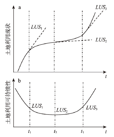
现有研究对土地利用可持续性没有一致定义。判断土地利用是否更加可持续的标准通常受学科背景、对象类型、决策偏好等价值取向影响,研究之间很难取得一致。可持续发展的最初内涵是“能满足当代人的需要,又不对后代人满足其需要的能力构成危害的发展。”[12]。土地是支撑人类发展的资源基础,可持续土地利用是可持续发展的必要非充分条件,同样应符合其内涵要求[38]。由于土地系统本身是一个镶嵌于“社会—生态”系统中的复杂自适应系统[39],土地资源与人类发展需求的关系也在不断演化,因此其可持续性与现状初始值不具有线性关系。这说明土地利用可持续性评价需要从从时点评价向连续时段评价转变。构建长期连续的土地利用变化曲线是分析可持续性的重要理论工具[29]。宏观尺度土地利用变化的“路径依赖”特征[40,41,42]提供了一个基本假设:一段时期的土地利用方式不会在某个时间点发生突变,即土地利用随时间变化的微分方程曲线具有连续性。据此可以构建土地利用变化的概念模型(图1),并比较土地利用状态与可持续性的关系。图1a中曲线为土地利用现状随时间变化曲线,曲线斜率代表当前时刻(如t1、t2、t3)的土地利用现状的变化趋势。图1b是图1a中曲线的微分方程曲线。理想情况下可持续土地利用变化曲线是一条随社会生产力水平提升而单调递增、微分始终为正值的曲线。
图1
 新窗口打开|下载原图ZIP|生成PPT
图1土地利用现状与可持续性概念模型
Fig. 1The concept model of land use status and land use sustainability (LUS)
实际评价中,由于并不存在时间完全连续的、可表征土地利用状态的数据,因此无法直接通过构建函数曲线来评价特定时刻的土地利用可持续性。以2个时间断面土地利用状态连线的斜率作为土地利用可持续性将产生巨大误差。因此需要通过建立tn-1和tn时刻土地系统变化关系,考虑系统外部发展形势需求判断土地利用变化态势,以此作为该时段土地利用可持续性。这需要进一步阐述土地系统内部结构变化与外部压力的关系,并解释如何量化这种关系对土地利用可持续性的影响。
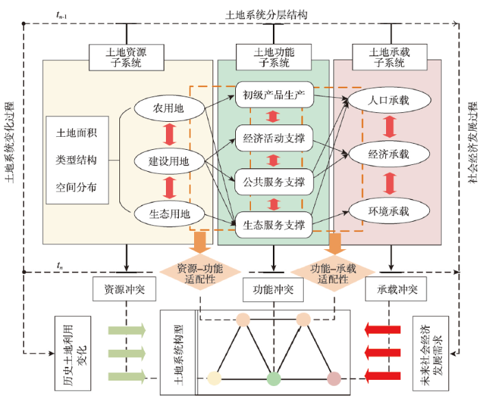
2.2 土地冲突—适配视角下土地系统解析
现有研究对土地系统分类与结构的认识并未取得一致,但普遍认为土地利用过程中人类活动与土地资源是相互联系但又相对独立的子系统。Ostrom认为资源单元、资源系统、管理系统和利用者是社会—生态系统中的核心子系统[43]。这种分类方式较好地体现了资源利用过程的人地关系特征和尺度性。本文将其应用于土地系统解析中并进行细化(图2)。土地系统的基础是各类土地资源(如耕地、林地、建设用地等),不同土地利用类型在特定空间范围内按照数量比例和空间拓扑规则进行组合,构成了土地资源子系统(Resource system, RS)。土地资源在人为和自然作用过程中提供产品或服务,表现出不同类型的土地利用功能(如粮食生产、气候调节等),各类功能的组合、冲突与权衡等构成了土地功能子系统(Function system, FS)。土地空间上的各类人类社会经济活动构成了土地承载子系统(Capacity system, CS),承载要素需要土地功能子系统支撑。一些非空间性的社会变化(如管理活动、文化发展、技术进步)不断驱动着土地系统朝社会适应方向发展。但发展过程中由于土地利用变化具有“路径依赖”特征,且土地系统内部要素作用传导需要时间过程,往往土地系统变化滞后于社会经济发展[44],形成土地系统内外压力差。图2
 新窗口打开|下载原图ZIP|生成PPT
图2土地系统冲突与适配解析
Fig. 2Connotation analysis of land system conflict and adaptation
土地系统的层级特征决定了土地系统变化的分级传导过程。CS直接包含具有空间特征的人类活动,其变化对FS提出发展需求,进而驱动RS变化。各子系统变化过程存在差异,导致子系统之间可能存在错配。子系统内部要素变化同样难以协同,部分要素适配性的提升可能会导致其他要素的适配性降低,形成土地子系统冲突。由此土地系统变化的外部压力和内部压力传导过程形成了传递关系,作为判断土地利用是否可持续的基本假设:① 适应系统外部发展需求的土地系统更加可持续;② 土地子系统之间的适配性越高越可持续;③ 土地子系统内部冲突越小越可持续。
土地系统在一定时段的冲突与适配变化可抽象为“M”结构(图2),两种子系统适配性构成外部驱动力的受力点,三种子系统冲突构成支撑点。当某种适配性较差时,相应土地子系统是否存在内部冲突已经不具有意义。而当某个土地子系统冲突过大,则会导致失去支撑作用,引起土地系统发展方向偏转。因此,“M”结构的支撑性和平衡性,共同决定了土地系统在外部压力下的变化态势,也就是土地利用可持续性。
3 研究方法
3.1 土地冲突与适配评价
基于土地冲突与适配的内涵解析,本文构建了包括5个类型、6个指标的评价指标体系(表1)。其中x1~x4的计算需要分别计算时间tn-1和tn的指标值并计算差值,从而反映评价时段土地子系统冲突的变化情况。x5、x6是复合指标,其内涵(以x5为例)是评价单元i的子系统RS中某土地利用类型面积占全研究区总面积比例从tn-1到tn年变化程度,与子系统FS中某功能j占全部单元j总和的比例从tn-1到tn年变化程度的适配性。子系统之间的适配关系有2个方向,资源—功能适配性为反向适配,即资源越少功能越高适配性越大;功能—承载适配性为同向适配,即功能越高承载越高适配性越强。该计算方法可以消除评价单元自然本底差异的影响,使得不同区域评价结果更具可比性。Tab. 1
表1
表1土地冲突与适配评价指标体系
Tab. 1
| 指标类型 | 指标层 | 计算方法说明 | 指标解释 |
|---|---|---|---|
| 资源冲突变化(RC) | 耕地细碎化程度变化(x1) | 使用景观聚集度指数(AI)反映耕地细碎化程度[45]。 | 耕地细碎化程度变化主要受建设用地扩展影响,是建设用地与农用地冲突的主要体现。 |
| 生态用地细碎化程度变化(x2) | 使用景观蔓延度指数(CONTAG)反映生态用地细碎化程度[46]。 | 反映生态用地的空间连通性。土地开发、土地开垦等活动会导致生态空间连通性下降。 | |
| 功能冲突变化(FC) | 生境质量变化(x3) | 使用InVEST模型中生境质量模块进行计算[47]。 | 功能冲突主要表现在经济活动、粮食生产等人类主导土地功能与土地对其他生物、资源功能供给的矛盾。InVEST模型生境质量通过量化人类对栖息地等的生态压力,反映土地利用生产、生活活动对生态活动的扰动。 |
| 承载冲突变化(CC) | 承载冲突指数变化(x4) | 承载冲突指数= | 综合反映人口增长、经济增长、环境恶化之间冲突关系。经济水平越高、环境质量越好、人口越少承载冲突指数越小,表明冲突越小。k为评价单元个数。 |
| 资源—功能适配性(R-F) | 资源—功能适配指数(x5) | 资源—功能适配指数是资源子系统各要素与对应功能的适配性加权求和。f和r分别为土地功能值和土地要素面积值,i为资源与功能要素适配类型数, | |
| 功能—承载适配性(F-C) | 功能—承载适配指数(x6) | 功能—承载适配指数是功能子系统各要素与对应承载的适配性加权求和。c为承载要素值,j为功能与承载要素适配类型数, |
新窗口打开|下载CSV
针对子系统内部要素,本文分别选取农用地、建设用地、生态用地面积作为RS要素,选取耕地净初级生产力(NPP)之和、夜间灯光总和、市级以上道路总里程数、植被指数(NDVI)总和代表FS要素,选取总人口、GDP总和、PM2.5浓度代表CS要素。基于这些指标可以计算x4~x6的值。
3.2 土地系统分类与可持续性计算
根据2.2.1,tn-1到tn土地系统变化形成的“M”结构受外力影响情况是决定土地利用可持续性的直接因素。不同评价单元在特定时段的土地冲突与适配情况存在差异,决定了“M”结构各节点的受力情况。为避免综合评价导致的特征模糊问题,本文按照不同节点受力大小的类型组合对“M”结构进行分类,并参考结构力学中静力学平衡方程相关计算方法[48,49],提出不同构型土地利用可持续性的计算方法(表2)。假设tn时外部驱动力为Fout,受规划、管理、文化、社会心理等变量影响,不同评价单元Fout不同。为简化这些变量影响,突出冲突—适配对土地利用可持续性影响,将所有评价单元的Fout统一设置潜在最大值。FR、FF、FC、FR-F、FF-C是“M”结构的支撑力,分别等于表1中RC~F-C的极差标准化值。表2中A1为基本“M”构型,其他构型为A1在某节点支撑力较小时进行舍去的情况。本文考虑评价精度和时间成本,经多次实验,采用自然断点法将指标值分为7个等级,设1~3级不具备支撑力。需要注意,由于适配性是外部驱动力的直接受力点,当适配性支撑点舍去时,唯一与其对应的土地冲突支撑点的支撑力也会舍去(如构型E1和E2)。土地系统“M”结构的支撑力越大、偏转越小,可持续性越强。Tab. 2
表2
表2土地系统构型分类及可持续性计算公式
Tab. 2
| 构型编号 | 土地系统构型 | 土地可持续性计算方法 | 构型涵义 |
|---|---|---|---|
| A1 | 总体结构适应发展需求能力强,系统内部发生偏转可能性小; | ||
| B1& B2 | 子系统间适配性较高,但存在土地冲突短板; | ||
| B3 | 子系统间适配性较高,功能冲突更严重,但结构总体比较稳定; | ||
| C1& C2 | 子系统间适配性较高,仅有1个子系统冲突得到改善,系统偏转可能性大; | ||
| C3 | 子系统间适配性较高,功能冲突得到改善,系统偏转可能性小; | ||
| D1 | 子系统间适配性较高,但子系统冲突较大,系统偏转受适配性影响; | ||
| E1& E2 | 一类子系统适配性较差,导致对于支撑点的冲突改善不再具有支撑性,其他类型冲突改善情况较好,系统偏转程度较小; | ||
| F1& F2 & F3 & F4 | 一类子系统适配性较差,另一类子系统适配性对应的两种冲突,仅有一种得到改善,系统偏转程度较大; | ||
| G1&G2 | 一类子系统适配性较差,另一类子系统适配性对应的两种冲突都未得到改善。系统无偏转。 | ||
| H1 | 两类子系统适配性较差,忽略冲突改善的支撑性。系统无偏转。 |
新窗口打开|下载CSV
3.3 研究区概况
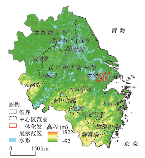
本文选择《长江三角洲区域一体化发展规划纲要》(以下简称《纲要》)中定义的长三角地区作为研究区。长三角地区位于中国华东地区(图3),位于114°54′E~122°12′E、27°09′N~35°20′N。根据《纲要》,长三角地区包括上海市、浙江省、江苏省和安徽省全域,总面积约35.8万km2,人口约2.2亿。其中中心区面积约22.5万km2,辐射带动长三角地区发展。上海青浦、江苏吴江、浙江嘉善为长三角生态绿色一体化发展示范区(面积约2300 km2),示范引领长三角地区更高质量一体化发展。图3
 新窗口打开|下载原图ZIP|生成PPT
图3长三角地区位置与地形
Fig. 3Location and topography of the Yangtze River Delta
长三角地区处于长江下游平原水网地区,北接黄淮海平原,东临黄海、东海,南与武夷山脉相接。长三角地区地形以平原、丘陵、山地为主,总体呈南高北低。气候湿润,四季分明,降水丰沛,属暖温带和北、中亚热带气候区。长三角地区,特别是上海、苏锡常杭嘉湖水网平原地区是中国发展起步最早、经济发展水平和工业化城市化水平最高、人口最密集的区域之一,同时也是中国发展模式转型探索最早、实践试点最多的区域之一,《纲要》更是提出要将长三角地区打造为全国高质量发展样板区。但长期以来该区域仍面临土地利用冲突大、矛盾多、转型困难的问题。据统计,2000年—2015年长三角地区GDP增长率、常住人口增长率分别为466.73%和13.42%,但在耕地占补平衡背景下耕地面积仍下降了5.29%,建设用地面积增长了33.49%。因此定量评价长三角地区土地利用可持续性,识别判断2000—2015年长三角各市县土地系统发展转型路径是否可持续,对中国其他区域具有借鉴意义。因此本文基于前文所述土地利用可持续性评价方法,以长三角地区306个县级行政单元为评价对象,对2000年—2015年土地利用可持续性进行实证分析。
3.4 数据来源
本文所用数据类型主要包括土地利用数据、社会经济空间化数据、道路矢量数据、夜间灯光遥感数据、植被遥感数据、空气污染空间化数据等。若无特殊说明,数据时间均为2000年和2015年。具体数据来源和说明见表3。Tab. 3
表3
表3数据来源与说明
Tab. 3
| 数据类型 | 数据来源 | 数据精度 | 数据说明 |
|---|---|---|---|
| 土地利用数据 | 中国科学院资源环境数据共享中心 | 1 km | 将耕地归为农用地,将林地、草地、水域、未利用地归为生态用地 |
| 社会经济空间化数据 | 中国科学院资源环境数据共享中心 | 1 km | 包括GDP和人口空间化插值数据 |
| 道路矢量数据 | https://sedac.ciesin.columbia.edu/data/ | 1∶100万 | 无 |
| 夜间灯光遥感数据 | http://www.noaa.gov/ | 1 km | 选用Version 4 DMSP-OLS Nighttime Lights Time Series,受数据限制选用2000年、2013年两期数据 |
| 净初级生产力NPP | http://www.noaa.gov/ | 1 km | MOD17A3产品,8天一期,选取6、7、8月NPP数据取均值 |
| 植被指数NDVI | 地理空间数据云 | 500 m | MYDND1M中国500M NDVI月合成产品 |
| PM2.5空间数据 | https://sedac.ciesin.columbia.edu/data/ | 1 km | PM2.5浓度,每立方米空气中可入肺颗粒物的含量,单位μg/m3 |
新窗口打开|下载CSV
4 结果分析
4.1 土地冲突与适配评价结果
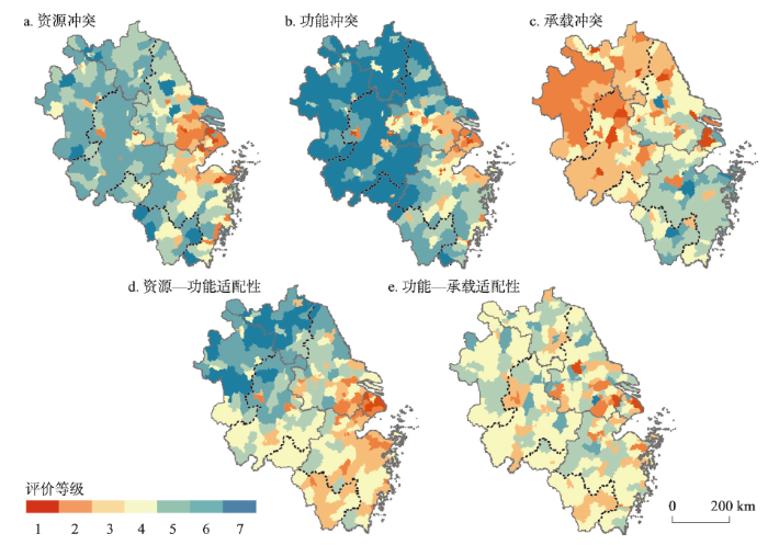
首先基于ArcGIS、Excel软件对评价单元x1~x6指标(表2)进行了计算,然后进行极差标准化处理,采用自然断点法划分为7个等级。用x1与x2等权重求和得到RC值,以x3~x6值分别作为FC、CC、R-F、F-C的值。结果如图4,并按照区域进行统计(表4)。从区域总体来看,长三角地区2000—2015年资源—功能适配性高于功能—承载适配性,功能冲突改善优于资源冲突和承载冲突。该时段是长三角地区经济高速发展和人口快速增长阶段,土地承载压力攀升、人口经济与环境要素冲突成为突出短板,尽管土地功能冲突有所改善但仍与承载压力存在错配。RC、FC、CC、R-F、F-C的标准差分别为0.088、0.149、0.120、0.094、0.068。总体都呈现中间值高度集聚、极端值分布极少的规律。由于中国是采用中央制定宏观政策、地方政府分级落实的土地管理体制,不同地区政策一致性较高,因此结果符合实际。图4
 新窗口打开|下载原图ZIP|生成PPT
图42000—2015年土地系统冲突与适配评价结果
Fig. 4Results of the land conflict and adaptation, 2000-2015
Tab. 4
表4
表4土地利用可持续评价结果分区统计
Tab. 4
| 区域 | RC平均值 | FC平均值 | CC平均值 | R-F平均值 | F-C平均值 | LUS平均值 |
|---|---|---|---|---|---|---|
| 长三角全域 | 0.682 | 0.796 | 0.462 | 0.669 | 0.563 | 0.595 |
| 长三角中心区 | 0.665 | 0.764 | 0.482 | 0.645 | 0.560 | 0.590 |
| 生态绿色一体化发展示范区 | 0.489 | 0.633 | 0.424 | 0.527 | 0.559 | 0.328 |
| 上海市 | 0.617 | 0.714 | 0.478 | 0.526 | 0.513 | 0.416 |
| 江苏省 | 0.677 | 0.792 | 0.437 | 0.697 | 0.573 | 0.583 |
| 浙江省 | 0.667 | 0.754 | 0.559 | 0.623 | 0.558 | 0.617 |
| 安徽省 | 0.709 | 0.849 | 0.400 | 0.705 | 0.567 | 0.615 |
新窗口打开|下载CSV
各指标结果具有显著的空间分异特征(图4)。RC和FC呈现以上海及临近市县为圆心向周边递减、城市化地区显著低于农业地区的规律。CC则呈现南高北低特征,与环境质量有较高空间相关性。R-F总体呈东南低西北高的特征,但在南京、合肥、芜湖等城区部分较低;F-C等级总体较低,多数县域在4级及以下,但在上海市周边及杭州周边分别呈低值和高质聚集。从省域分布来看,上海市除CC外其他指标均为各省最低;江苏省CC为各省最低,其他指标均位列第二;浙江省各指标均排第三位;安徽省RC、FC和R-F为各省最好,但CC最差。从县域分布看,RC、FC、CC、R-F、F-C的最高值分别位于泰州泰兴市、南京高淳区、杭州上城区、宿迁沭阳县和无锡滨湖区,最低值位于上海嘉定区、杭州滨江区、徐州贾汪区、上海浦东新区和扬州江都区。长三角中心区除CC外各指标均低于长三角全域平均值,生态绿色一体化发展示范区5项指标分别比全域均值低28.30%、20.48%、8.23%、21.23%、0.71%。
4.2 土地系统构型分类结果
根据4.1指标计算结果和表2的方法,对评价单元进行土地系统构型分类(图5a、图5b)。结果显示,研究区17种土地系统构型均有涉及。A1和B1构型数量远多于其他类型,合计占全部单元的51.96%,主要分布在安徽全省大部、江苏除苏锡常外区域、浙江西部和东南部山地区,但不包括这些区域中大都市地区。这些类型支撑性与均衡性较好;B2和B3类型主要分布在B1周边;E1和E2类型连绵分布于浙江金衢盆地到宁绍平原一线,以及江苏安徽规模较大城市周边;F1~H1主要分布于上海、苏锡常杭嘉湖、浙江绍兴、宁波、丽水等市,江苏南京、南通等市及安徽合肥、芜湖等市,这些类型均存在土地功能与承载错配问题。图5
 新窗口打开|下载原图ZIP|生成PPT
图5土地系统构型与土地利用可持续性评价结果
Fig. 5Land system structures and LUS evaluation results
4.3 土地利用可持续性评价结果
根据表2,为计算LUS需要给出Fout的值。本文中按照极差标准化计算方式得到“M”型结构5个支撑力的理论最大值均为1,因此设所有评价单元Fout均为理想最大值5。该方法简化了评价单元外部因素需求,聚焦于土地系统本身对可持续性的影响。根据4.2可以得LUS评估结果(图5c)。结果显示,评价单元的LUS范围是0.20~1.58,均值为0.595。按照自然断点法分为7个等级(图5c),1级至7级县域单元个数分别为63、30、123、15、32、37和6。LUS值最大的单元是绍兴诸暨市,LUS均值最小的单元(构型为H1)单元有41个,主要包括上海市、浙江宁波、台州、丽水、江苏南京、苏州、无锡、常州等市的主城区及周边市县。根据图5b,A1~H1各类构型的LUS均值总体呈下降趋势,但也存在B2、C2等非稳定构型具有较高LUS情况。表明土地利用可持续性既受“M”结构差异影响,也能体现某节点支撑力的突出性。因此实践中评价单元可以根据自身资源环境与社会经济特征制定差异化政策,如均衡发展策略或专注某一方向发展策略。从空间分布来看,LUS 1、LUS 2级单元主要分布在上海大都市圈周边、杭州和南京城区等高度城市化地区,及金衢盆地到丽水一带;LUS 3级单元主要分布在江苏中部和北部和安徽大部分的农业发达区;LUS 4级单元零星分布于研究区;LUS 5级单元主要分布于安徽合肥、芜湖、马鞍山的非城区市县,及江苏扬州、徐州、盐城等部分市县;LUS 6、LUS 7级单元集中分布于江苏、安徽、浙江三省交界丘陵山地区,雁荡山区至宁波、台州沿海市县一带。进一步对空间分布进行冷热点分析(图5d)可知,研究区主要包括3个热点集中区(江苏、安徽、浙江三省交界,台州市南部和温州市西部)和4个冷点集中区(上海及周边市县,南京江宁区、合肥市和宁波市)。冷热点区域大部位于长三角中心区范围内,生态绿色一体化发展示范区位于最大冷点区中心位置。太湖区域位于研究区冷热点邻接区域,区位重要性显著。
从省域分布来看,浙江、安徽LUS总体相近,优于江苏与上海,且高于研究区LUS均值。上海LUS均值比研究区均值低30.08%。上海、江苏、浙江、安徽的LUS标准差分别为0.184、0.278、0.353、0.220,上海LUS呈低值均匀分布。长三角中心区与长三角全域LUS接近,但生态绿色一体化发展示范区3个市县的均值仅达全域LUS均值55.13%。
比较LUS与各项冲突、适配指标可知,支撑力与均衡性均对LUS有较大影响。浙江省各项冲突、适配指标位列4个省市中第三位,但稳定构型(如A1、B3、C3等)单元占比较高、不稳定构型(如C1、C2等)占比较少,综合分析得到的LUS均值位列第一。
总体来看,LUS评价结果呈现城乡梯度、陆海梯度、南北纬度差异,与长三角地区资源环境与经济活动、人类活动强度[50]、生境质量差异[51]趋势具有一致性。同时,部分典型发展类型区LUS结果呈现独特性,例如实施“沿海大开发战略”(传统经济主导型发展战略)的连云港市(LUS均值为0.544)、南通如东县(LUS = 0.20)等地区土地利用可持续性显著低于实施“八八战略”(新型绿色发展战略)的绍兴诸暨市(LUS = 1.58)、湖州安吉县(LUS = 1.15)等,而在苏北、安徽等传统农业区,尽管土地系统构型稳定(以A1、B1为主)、土地资源与功能冲突较小,但与社会经济发展进一步发展需求的不匹配也导致了该区域低水平的土地利用可持续性。因此本文LUS评价方法可以较好地兼顾总体趋势判断和关键区域识别。
5 讨论
本文提出的土地利用可持续评价方法可以为土地可持续管理决策提供新的思路。现行管理体制下,不同土地利用类型及社会经济发展的管理分散于各部门。受职责划分与利益冲突影响,各部门在土地利用与管理中面临规划目标不一致(如耕地保护与城市发展,生态保护与资源开发)、管理思路与方式存在差异(如环境优先或经济优先,农村优先或城市优先)的问题[52]。这些问题在土地系统中表现为土地子系统间发展的不匹配和子系统内的要素冲突。造成这些问题的原因在于缺乏统一的土地管理价值导向。本文提供了一种土地管理与规划的图景,即构建兼具内部稳定和外部适应特征的土地系统。同时本文评价方法提供了量化工具:以土地利用可持续性作为土地系统运行的评价标准,以土地系统构型转变作为土地利用转型发展方向,以调控土地子系统适配性与要素冲突为提升土地利用可持续性路径。土地系统是一个开放、变化、复杂巨系统。本文评价方法尚处于理论思辨和初步实证阶段,仍需进一步完善:① 理论解析方面,本文提出的框架是以人类发展需求为分析起点,对于短时期人类不可利用的非直接生态价值[52]并没有予以考虑。其次,本文所提的土地冲突与适配性限于评价单元的内部,对于评价单元之间的冲突、适配没有作过多讨论;② 评价方法方面,目前并没有对各土地子系统之间的要素进行细分,土地利用类型、功能、承载等相关指标选取具有典型性但不能保证全面性。土地系统构型分类计算方法较简单,仅以自然断点法分级确定“M”结构节点是否具有支撑力的阈值,虽可以突出结构差异,但会导致产生稳定性与偏转性计算误差,影响不同构型结果的可比性;③ 案例评价方面,本文对所有评价单元的外部驱动力进行统一,便于控制变量与结果分析。但在实际管理决策中,应当对外部压力的值具体化、本地化,以确保评价结果的实用价值。为进一步提升研究理论与应用价值,后续研究将在理论解析、指标选取、函数变量设置等方面继续完善。重点围绕土地系统构型的结构特征与影响因素进行解析,提升土地系统分类可持续性评价精度。
6 结论
本文从土地可持续内涵解析出发,基于土地系统冲突与适配视角,提出了一种新的土地利用可持续评价框架。与以往评价方法相比,本文方法主要有以下区别:① 面向土地对社会经济发展的支撑性。脱胎于土地适宜性评价的传统土地利用可持续评价更关注土地本身的性质、质量、利用强度等。本文基于土地系统外部变化施压及内部支撑性视角,以土地系统“M”结构支撑性与平衡性表征土地系统可持续性;② 从要素转向系统评价。考虑土地系统的分层分类特征,本文从关注土地要素自身的数量、结构、功能、效率等转向关注各子系统之间冲突适配关系;③ 从时点转向时段评价。可持续发展“面向未来”的特征提出了从现状评估向趋势判断的评价需求,本文构建了适用于现有数据条件的评价方法,以一定时段内的土地子系统变化的适配关系及子系统内冲突改善情况判断土地系统可持续性。为验证评价方法的适用性与有效性,本文以长三角地区为例对县域单元的土地冲突与适配性、土地系统构型以及土地利用可持续性进行了分析,得到如下结论:① 根据土地利用可持续性内涵,可以按土地系统的分层体系构建包括“资源子系统冲突”、“功能子系统冲突”“承载子系统冲突”“资源—功能适配性”“功能—承载适配性”的“M”型土地系统构型,以一段时期“M”构型的支撑性与平衡性反映土地利用可持续性,借鉴静力学平衡方程可以得到不同构型下土地利用可持续性计算公式;② 长三角地区RC、FC、CC、R-F、F-C平均值分别为0.682、0.796、0.462、0.669、0.563,长三角中心区除CC外各指标均低于长三角全域平均值。生态绿色一体化发展示范区5项指标分别比全域均值低28.30%、20.48%、8.23%、21.23%、0.71%。各项冲突适配指标具有显著空间分异特征,体现在城乡差异、南北差异、沿海内陆差异等;③ 长三角地区包含17种土地系统构型,其中A1、B1、H1合计占全部县域的65.36%,呈现最稳定与最不稳定构型两极分布多、中间构型数量少的特征。长三角地区LUS结果范围是0.20 ~ 1.58,平均值为0.595,其中浙江>安徽>长三角均值>江苏省>上海市,生态绿色一体化发展示范区仅达均值的55.13%。长三角地区分布有3个LUS热点集中区和4个冷点集中区,全部位于长三角中心区范围。LUS结果空间分布趋势与长三角地区资源环境与社会经济分异高度相关,但在典型发展类型区呈现明显差异。
参考文献 原文顺序
文献年度倒序
文中引用次数倒序
被引期刊影响因子
DOI:10.1002/sd.v26.1URL [本文引用: 1]
DOI:10.11821/dlxb201912013 [本文引用: 1]

Since the reform and opening up in 1978, China has created a miracle of long-term high-speed economic growth, but the relationship between man and nature has suffered a serious damage, which is highlighted by the excessive consumption of resources and the intensification of environmental pollution. As a result, China is facing a slowdown in development. At the same time, China needs to maintain a certain speed of development in order to realize the dream of a powerful nationality entering the ranks of developed countries in 2050. To this end, China is facing transformation development. Now Chinese scholars and governments need to answer this kind of question: What economic growth rate is expected along with the corresponding development modes or means of regulation in the medium and long term? The growth development mode of the national economy is influenced and even dominated by the resource and environment support system. This study is intended to reveal the coupling relationship between economic growth, development modes and the supporting system, simulate the interaction process between them, explore the possible options for future economic growth and its requirements for the resource and environmental support system (the main factors), and provide early warning regarding China's environmental and development status. The results show that in order to achieve the development goal of entering the ranks of developed countries in 2050 and maintaining a fine ecological environment, the suitable growth rate for China's economy is 3.8%-6.3% on the premise that technological progress will improve resource utilization efficiency and reduce pollution emissions. Within this speed range, on the one hand, the smaller development velocity may be adopted to reduce the pressure on resources and environment, on the other hand, higher velocity can be adopted given that we are optimistic about the technological advances. The model proposed could help to compare different development scenarios and determine a better development mode; this way provides decision support for sustainable development. This study is a response to the "Future Earth" framework document. It develops the theoretical system of the resource and environmental carrying capacity in terms of development speed. It has important theoretical exploration significance and application value.
[本文引用: 1]
DOI:10.1007/s11442-016-1321-0URL [本文引用: 1]
DOI:10.1016/j.landusepol.2020.104531URL [本文引用: 1]
DOI:10.11821/dlxb202002002 [本文引用: 1]
In this paper, we review and sort out research progress on development geography since the 20th century, involving its connotation and theory, fields and methods, and development trends in this paper. Specifically, we systematically reviewed the research and application of development geography in the fields such as in the convergence of underdeveloped countries or regions, the convergence in the process of improving the quality of life in developed countries or regions. Then, in line with the analysis of the research progress on development geography in foreign countries, we indicate the development conditions and disciplinary advantages of development geography in China. Further, we pointed that future development geography research in China should focus more on the latest international academic frontier research and national macro-strategic needs. The future research of development geography should be guided by the theory of sustainable development, with the core of improving the sustainable livelihood capacity and regional green development level in underdeveloped areas, and aiming at constructing industrial policy and development geography theory and interdisciplinary integrated research system, and focusing on research on the spatial pattern, diffusion characteristics and convergence mechanism of regional development, to explore the regulatory policies and scientific paths that serve regional economic construction and industrial development.
[本文引用: 1]
[本文引用: 1]
[本文引用: 1]
PMID:24851141 [本文引用: 1]
This issue of provides an overview of recent advances in Land System Science while at the same time setting the research agenda for the Land System Science community. Land System Science is not just representing land system changes as either a driver or a consequence of global environmental change. Land systems also offer solutions to global change through adaptation and mitigation and can play a key role in achieving a sustainable future earth. The special issue assembles 14 articles that entail different perspectives on land systems and their dynamics, synthesizing current knowledge, highlighting currently under-researched topics, exploring scientific frontiers and suggesting ways ahead, integrating a plethora of scientific disciplines.
DOI:10.1016/j.landusepol.2003.10.004URL [本文引用: 1]
DOI:10.1016/j.cosust.2019.04.006 [本文引用: 1]
Implementing the 2030 Agenda may well translate into competing claims on scarce land resources. Thus, there is a call for a better linkage of science, policy, and practice to navigate development trade-offs and use co-benefits. We found that since 2015, scientists formally associated as members to the Global Land Programme (GLP) have mainly researched on topics that are relevant to the 2030 Agenda, but only half of the sampled publications actually address interactions between its targets. Of those, many are concentrating on the interactions between climate action, environmental targets, and food security, while interactions between land-related issues and poverty are addressed much less often. Our results point to opportunities for further strengthening GLP's capacity to engage in transdisciplinary dialogue and interdisciplinary collaboration and respond to the knowledge needs of societal partners.
[本文引用: 1]
[本文引用: 1]
DOI:10.1007/BF02394674URL [本文引用: 1]
DOI:10.1017/S0376892900016702URL [本文引用: 2]
DOI:10.1006/jema.1999.0276URL [本文引用: 1]
[本文引用: 1]
[本文引用: 1]
[本文引用: 1]
[本文引用: 1]
DOI:10.2307/141708URL [本文引用: 1]
[本文引用: 1]
[本文引用: 2]
[本文引用: 2]
DOI:10.1016/j.habitatint.2010.06.006URL [本文引用: 1]
DOI:10.1016/j.jenvman.2018.09.053URL [本文引用: 1]
DOI:10.1016/j.jenvman.2017.09.080URL [本文引用: 1]
DOI:10.1007/s10661-006-9595-9URL [本文引用: 1]
DOI:10.1016/j.ecolecon.2008.11.017URL [本文引用: 1]
[本文引用: 1]
[本文引用: 1]
DOI:10.1016/j.ecolecon.2008.11.016URL [本文引用: 1]
DOI:10.1016/j.ecolind.2010.08.001URL [本文引用: 1]
URL [本文引用: 1]
[本文引用: 1]
[本文引用: 1]
[本文引用: 1]
[本文引用: 1]
[本文引用: 2]
[本文引用: 2]
[本文引用: 1]
[本文引用: 1]
[本文引用: 1]
[本文引用: 1]
[本文引用: 1]
[本文引用: 1]
[本文引用: 1]
[本文引用: 1]
DOI:10.31497/zrzyxb.20190402URL [本文引用: 1]
[本文引用: 1]
[本文引用: 1]
[本文引用: 1]
[本文引用: 1]
[本文引用: 1]
DOI:10.11821/dlxb202006010 [本文引用: 1]
With the rapid increase of productivity, the intense conflict between human and environment has given birth to the discipline of spatial planning. As an indispensable tool for reconciling man-land relationship, high-quality spatial planning is essential for the reasonable utilization of space resources and the promotion of sustainable socio-economic development. Adapting to the rules of man-land interaction is the premise of conducting high-quality spatial planning, which is unachievable without the support of geography. Using bibliometric and typical case analysis method, this study conducts an in-depth analysis of researches and practices on foreign spatial planning from the perspective of geography. The main findings were demonstrated as follows: (1) as a science focusing on "space", geographical theories and methods are indispensable in the reform of spatial planning. Traditional geographical theories still play a pivotal role in spatial planning, while the post-structuralist geographical theories such as relational geography are increasingly applied. Currently, the traditional spatial planning based on an isolated perspective and linear growth can hardly meet the requirements of socio-economic development, while the geographical perspective based on the relationship network combined with multiple developmental trajectories may be conducive to promoting the rationalization of spatial planning. (2) A country's geographical research will greatly affect its spatial planning. For example, the central place theory has made Germany one of the countries with the most balanced spatial development, while the geographical research achievements in Japan have supported the formation of the territorial development pattern dominated by three urban agglomerations. Thus, improving the geographical research level is a cornerstone to promote the healthy development of spatial planning. For China, in the process of promoting the localization of foreign theories, geographers should proceed from the perspective of man-land relationship areal system, in order to provide scientific guidance for resolving unprecedented fierce conflicts between human and environment. (3) Because of the regionality, comprehensiveness, complexity and multi-scale characteristics of the man-land relationship areal system, the construction of a spatial planning system with distinct levels and complementary functions is the guarantee for the operability of spatial planning. Overall, as a science of humanistic pragmatism, geography ought to propose scientific and reasonable policy suggestions aimed at the major national need—the reform of spatial planning, through innovative theories, methods and technological approaches that root in real-world situations, thus contributing to the harmonious development of man-land relationship.
[本文引用: 1]
DOI:10.1016/j.landusepol.2010.11.009URL [本文引用: 1]
[本文引用: 1]
[本文引用: 1]
DOI:10.1111/j.1468-0297.1997.tb00063.xURL [本文引用: 1]
DOI:10.1016/j.landusepol.2015.01.017URL [本文引用: 1]
DOI:10.1016/j.landusepol.2019.04.008URL [本文引用: 1]
[本文引用: 1]
DOI:10.1016/j.gloenvcha.2018.08.006URL [本文引用: 1]
DOI:10.1016/j.landusepol.2019.104185URL [本文引用: 1]
DOI:10.1016/j.landurbplan.2019.05.004 [本文引用: 1]
The increasing global population requires new infrastructure and urban development, and these land use changes have an impact on habitats and their ecological connectivity. To anticipate and minimise these impacts, environmental and urban planners require tools and methods that they can use at early planning stages. This paper investigates and selects landscape ecology techniques that can be used by planners to assess the effects in terms of changes in habitat loss, fragmentation and ecological connectivity due to expected land use changes. The selected techniques were tested in Luxembourg. Twelve landscape metrics, four connectivity indices, and one connectivity model were selected based on their straightforwardness, widespread application, and accessibility. Land cover maps and proposed areas of urban development up to 2030 were used as input data, together with adapted resistance surfaces from previous studies and a matrix of presence/absence for six target species. The combined analysis reveals a trend of increasing habitat fragmentation and loss of habitats, as well as a reduction of ecological connectivity with regard to all the targeted species, and suggests that this trend will likely continue in the near future. The selected landscape metrics, connectivity indices, the connectivity model and the software used to run them makes the abovementioned techniques easy to use by non-experts, and their combination helps to reduce some of the limitations of each individual technique. Both aspects might be useful in order to mainstream the use of landscape ecology techniques in spatial planning processes.
DOI:10.1016/j.scitotenv.2018.05.383URL [本文引用: 1]
DOI:10.1016/j.apm.2018.07.005URL [本文引用: 1]
[本文引用: 1]
[本文引用: 1]
[本文引用: 1]
[本文引用: 1]
[本文引用: 1]
DOI:10.1016/j.ecoser.2020.101096URL [本文引用: 2]
