 ,陕西师范大学地理科学与旅游学院,西安 710062
Palaeoflood deposits in the Zoige Basin and the enlightening on the formation of the Yellow River drainage systemon the Tibetan Plateau
HUANG Chunchang,School of Geography and Tourism, Shaanxi Normal University, Xi'an 710062, China收稿日期:2019-12-2修回日期:2020-12-7网络出版日期:2021-03-25
| 基金资助: |
Received:2019-12-2Revised:2020-12-7Online:2021-03-25
| Fund supported: |
作者简介 About authors
黄春长(1953-), 男, 陕西彬县人, 教授, 博士生导师, 中国地理学会会员(S110000052M), 主要从事环境演变与灾害研究。E-mail:

摘要
关键词:
Abstract
Keywords:
PDF (6795KB)元数据多维度评价相关文章导出EndNote|Ris|Bibtex收藏本文
本文引用格式
黄春长. 若尔盖盆地河流古洪水沉积及其对黄河水系演变问题的启示. 地理学报[J], 2021, 76(3): 612-625 doi:10.11821/dlxb202103009
HUANG Chunchang.
黄河源区现代水系的形成与发展演变,是青藏高原环境演变的重要组成部分。其中若尔盖盆地古湖泊的消亡与黄河干流的贯通,则是青藏高原东部黄河水系格局形成与发展演变过程当中具有标志性的地貌与水文事件。这个重要事件导致青藏高原面原本是内流水系的广大区域,转变为外流水系地区,使得玛曲水文站以上干流长度910 km,控制流域面积达86050 km2的高山高原地区的冰雪融水与大气降水径流通过黄河东流入海。
1 若尔盖盆地地理概况
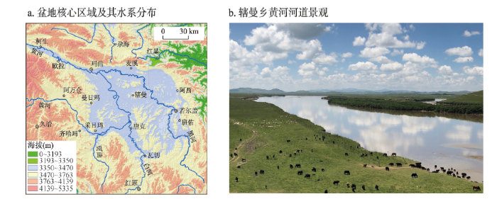
若尔盖盆地的核心部分处于海拔高程3400~3450 m之间,其范围西起玛曲县曼日玛乡,东至若尔盖县班佑乡,宽度约为90 km,南起红原县瓦切乡,北到若尔盖县麦溪乡,长度约为100 km。在盆地周边3440~3445 m隐约可见有古湖岸线和湖蚀台地,盆地内部为沼泽湿地和亚高山草甸,散布其间的低缓基岩丘陵的周边,在该高程也有湖岸线出现(图1a)。盆地西有阿尼玛卿山、北为西倾山,东有岷山,南有邛崃山阻隔,这些山地在末次冰期常有古冰川发育,从成排分布的古冰斗底部高程,可推知末次冰期古雪线在海拔4000 m左右,而古山谷冰川的冰舌伸展到3800 m高程。在果洛山(年保玉则)北坡的哈曲,末次冰期山谷冰川长度12 km,而更早冰期的山谷冰川长度可达20 km[1,2]。在阿尼玛卿山、果洛山和岷山海拔超过5000 m的主峰地区,仍然有现代冰川发育,目前都处于快速消融退缩之中。图1
 新窗口打开|下载原图ZIP|生成PPT
图1若尔盖盆地核心区域及其水系分布和黄河河谷景观
注:图b由黄春长拍摄于2018年8月。
Fig.1The Zoige Basin and the drainage system of the Yellow River and the landscape
从地质构造来看,若尔盖盆地处于东昆仑大断裂东段,是被不同方向断裂围绕着的一个相对沉降区域。盆地的基底最主要基岩层为三叠系灰黑色炭质板岩[3]。我们在2019年8月的调查发现,在黄河第一湾右岸阿拉克卡—甲央玛岩丘,就是由这种炭质板岩构成,岩层延伸到黄河岸边构成了黄河第二级阶地的基座,高出夏季河水位2.5~3.0 m。在有些地段有白垩系红色沙砾岩分布,玛曲县南黄河左岸欧热纳卡—阿米欧拉岩丘是由这种沙砾岩构成,其延伸到黄河岸边构成了黄河第二级阶地基座,高出夏季河水位9~10 m。在盆地周边或者内部岩丘坡脚,偶见有上第三系红土坡组(N2h)砖红色或黄橙色粉沙质粘土层出现。我们的野外调查在辖曼乡黄河右岸呜哇岩丘坡麓,发现被风成黄土夹风成沙覆盖的这种致密坚硬的古老粘土层剥蚀面,其向黄河延伸构成了第一级阶地的基座,高出夏季河水位1.0~2.0 m。通过盆地内部黑河下游钻孔揭露的第四系松散沉积物地层,厚度可达120~310 m,主要是有河湖相沉积物构成[4,5,6,7,8]。
若尔盖盆地属高原寒温带湿润季风气候,年均温1.1~1.2 ℃,年降水量600~650 mm,多集中于5月下旬—7月中旬。每年9月下旬土地开始冻结,5月中旬完全解冻,冻土最深达72 cm。年平均日照2400 h,牧草生长期可达190 d。受到全球变暖影响,若尔盖盆地年平均气温上升与降水量下降趋势明显[9]。盆地内部草原地表植被主要是亚高山草甸,发育形成了灰黑色的草甸土壤。湿地沼泽草甸则发育沼泽土或者泥炭土类土壤,由于全球变暖和人为疏浚影响,湿地沼泽面积持续萎缩。盆地周边基岩山丘阴坡常有云杉、冷杉构成针叶林。河岸与心滩有密集的柳与沙棘灌木丛覆盖。但是由于高原风力强劲,盆地内黄河干支流河道高河漫滩表面堆积的河流洪水细沙与粉沙质沉积物,多被风力改造为斑状分布的沙地或者沙丘。而基岩山丘坡脚或者冰水扇—洪积扇中上部相对稳定的平缓地面,则接受沙尘暴堆积形成细沙质黄土与细沙质粉沙质地的古土壤和现代草甸土壤。由于全球变暖、鼠害、过度放牧和人类活动影响,若尔盖草原土壤退化问题突出,盆地荒漠化的土地已经超过3200 km2面积[10,11]。
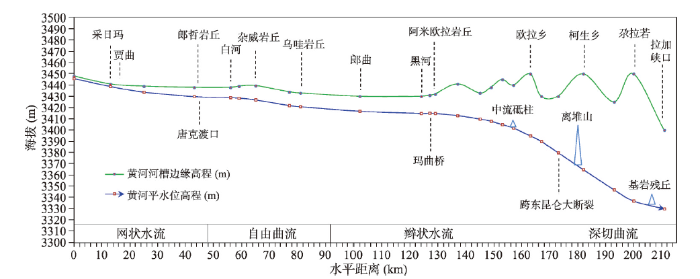
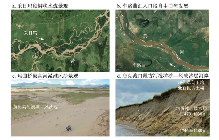
黄河在若尔盖盆地内流程约110 km,自采日玛乡出基岩高山峡谷向东南流入若尔盖盆地,在白河口拐弯向西北流,在玛曲县城南段流出盆地,河道形成一个巨大的U形弯曲,被称为黄河“第一湾”(图2)。沿途随着河槽比降、河床质、悬移质泥沙含量变化,以及支流入汇的影响,黄河干流河型反复多次变化[12,13]。通过沿程考察观测,发现在采日玛乡—唐克渡口段30 km,纵向比降0.300‰,河岸高度由2~3 m逐渐增加到6~8 m,黄河干流还没有下切到湖盆底的沉积物之中,也没有形成单一的河道,仍然在其自身的沉积物当中反复分叉,流路散乱,成为网状水流(图3a、3b);唐克渡口—车洛曲段40 km纵向比降0.225‰,河岸高度10~12 m,河岸基底出现兰灰色粉沙质粘土淤泥层(图3d),表明河槽下切到了古湖相沉积层,形成了明显的河槽,蜿蜒曲折的流动,为自由曲流;车洛曲—黑河口50 km纵向比降0.120 ‰,河岸高度10~15 m,某些河段切入第三纪黄橙色粘土层之中,河槽相对比较稳定,水流在河槽内分叉,成为辫状水流;黑河口—拉加峡入口90 km纵向比降从0.330‰逐渐增大到1.450‰,河岸高度30~70 m,为峡谷式深切曲流,众多弯道凹岸冰水扇—洪积扇沙砾石层坍塌后退,在大草原边缘形成高出河水位60~70 m的直立陡崖,河道沿程在若干地点的河道中央出现基岩残丘、岩岛和离堆山,表明河槽的深切过程仍然在持续进行着。
图2
 新窗口打开|下载原图ZIP|生成PPT
图2黄河若尔盖盆地—玛曲—欧拉秀玛断陷谷地黄河河槽纵向断面
Fig.2The longitudinal profile of the Yellow River passing through the Zoige Basin
图3
 新窗口打开|下载原图ZIP|生成PPT
图3若尔盖盆地黄河河道与河岸沉积物
注:图c和图d由黄春长拍摄于2018年8月;图d数据来源于文献[19]。
Fig.3River channel pattern and the sediments along the Yellow River within the Zoige Basin
玛曲桥段河槽狭窄,是黄河流出若尔盖盆地,进入西倾山与阿尼玛卿山之间的断陷谷地草原的卡口,河槽宽度约270 m。这道宽谷沿着东昆仑大断裂成NWW-SEE方向发育,长度达90 km,宽度稳定在5 km,谷底草原地面主要由出自于两侧山地的巨大冰水扇—洪积扇联合构成。黄河蜿蜒曲折顺两岸冰水扇—洪积扇之间的洼地西流,在欧拉秀玛乡敦宏村向西北流进入拉加峡高山峡谷。在玛曲县—欧拉乡河段,出自于西倾山的冰水扇—洪积扇强烈发育,迫使黄河向南侧移到阿尼玛卿山北麓的基岩山丘脚下。在欧拉乡—欧拉秀玛乡之间,出自于阿尼玛卿山的巨大冰水扇—洪积扇迫使黄河北移到西倾南麓的基岩山丘脚下。因此黄河干流在欧拉乡与柯生乡之间哇合村,从南向北穿过东昆仑大断裂带。黄河自采日玛进入若尔盖盆地,到玛曲桥流出盆地,然后经过断陷谷地草原在欧拉秀玛乡那浩若接纳西柯河之后,在西倾山南麓进入拉加峡口,沿程大约200 km,绝大多数弯道的凹岸都因为夹有松散的河漫滩沙—风成沙层或者冰水扇—洪积扇沙砾层,受河水冲刷而持续不断地坍塌后退,形成了悬崖或者陡峭河岸(图3d)。
玛曲水文站以上黄河干流长度910 km,流域面积达86050 km2,其中黄河吉迈—玛曲水文站之间控制流域面积41090 km2,唐克水文站控制白河流域面积5480 km2,若尔盖水文站控制黑河流域7850 km2面积[14]。玛曲水文站断面黄河槽宽度270 m,平水位水深约3.5~4.0 m。黄河在该断面年平均流量在1970年代为472.6 m3/s,到1990年代减小到393.3 m3/s。玛曲站年径流总量和年输沙量也表现出减少的趋势,其中在1970—1996年分别为148.35亿m3和499.47万t,在1997—2006年分别为125.04亿m3和278.83万t [15]。黄河上游在2018年7月12日发生大洪水,玛曲站洪峰流量2870 m3/s。我们在8月初调查发现在唐克渡口、杂威和欧强村段河岸洪痕与SWD尖灭点高出河水位2.5~3.0 m。若尔盖盆地及其周边是黄河上游最主要的暴雨发生区,自从1959年以来玛曲水文站观测记录的大洪水洪峰流量在2500~3000 m3/s之间,其中1981年发生突破纪录的特大洪水事件,洪峰流量达4300 m3/s [16,17]。在分析大暴雨和气象水文资料的基础上,采用水文统计与水利工程洪水设计方法,推算出黄河玛曲水文站可能最大洪水PMF的Qm值为7730 m3/s,其下游唐乃亥站为9440 m3/s [18]。
2 若尔盖盆地古湖泊消亡与黄河贯通年代研究现状
2.1 盆地沉降中心钻孔岩芯沉积物记录
若尔盖盆地环境演变问题曾经得到地貌与第四纪地质学界的关注。20世纪90年代初期在盆地北部黑河下游沉降中心地区钻孔,先后获得长度120 m的RH沉积物岩芯,和长度达310 m的RM沉积物岩芯。通过多种指标分析研究,揭示了青藏高原800~900 ka以来构造隆升与长期演化问题[4,5,6,7]。对于这两个钻孔沉积物岩芯上部多种理化指标高分辨率分析研究,结合14C测年断代,认为在RM钻孔深度6.30 m的青灰色古湖相沉积物,其14C年龄21600±1500 a BP;深度8.25~8.33 m处14C年龄为(33150±2300) a BP[20,21]。在RH岩芯深度12.40 m,即14C年龄37630±1070 a BP,沉积物当中总有机质(TOC)、氢指数(HI)和总色素等指标突然降低,指示若尔盖湖泊环境被河流洪积—冲积环境所取代[22]。在黑河口河岸剖面深度3.0 m,出现洪积—冲积物覆盖青灰色粉沙质淤泥层的清晰界限,其14C年龄为(24830±1580) a BP,从而认为黄河袭夺若尔盖古湖发生在38.0~35.0 ka,并且认为其与青藏高原北部发生在50.0~30.0 ka的新构造抬升运动相关[23]。作为RH钻孔岩芯顶部地层的补充,对于其旁侧冲沟岸剖面的研究,表明青灰色沙夹淤泥层顶部14C年龄为(20340±550) a BP;对于黑河口河岸剖面的研究,表明青灰色粉沙质淤泥与黄色沙互层段顶部淤泥层14C年龄为(18745±360) a BP,因此认为现代黄河是在距今20 ka前切穿了若尔盖湖盆,与距今30~20 ka前的新构造运动抬升有关[24]。通常,古湖相沉积物会受到“老碳效应”影响,黑河下游RH岩芯深度12.40 m湖相层转变为河流沉积层,14C年龄(37630±1070) a BP,似乎应当考虑排除老碳影响问题[25,26]。2.2 河岸阶地沉积物与动物化石反映的黄河发育演变
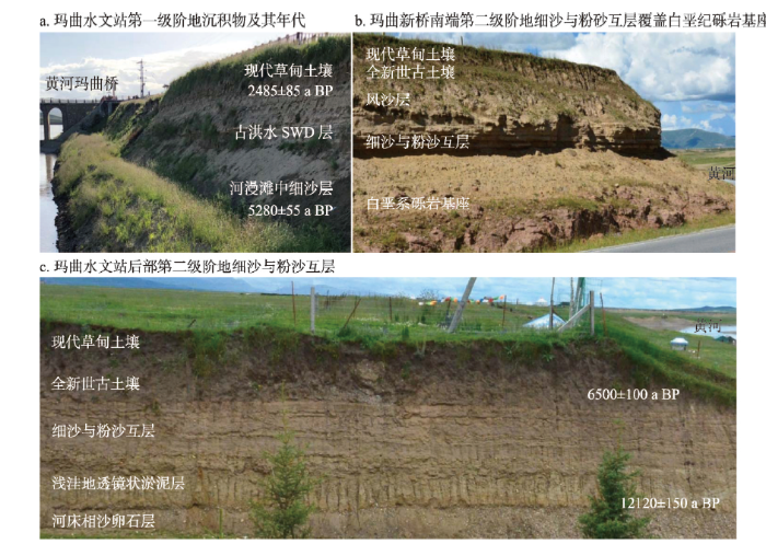
河流阶地是河流发展演变历史的直接记录。若尔盖盆地黄河及其支流的阶地及其沉积物受到地貌与第四纪****的重视。20世纪80年代及其以前出自于河岸沉积物当中的哺乳动物化石,成为理解若尔盖盆地内河湖环境演变问题的重要证据。在唐克白河汇入口以下索克藏寺北侧黄河右岸,覆盖在三叠系灰黑色板岩基座上的松散沉积物,厚度可达10 m,构成了基座阶地,为黄河第二级阶地。据调查在地表以下8.0~9.0 m深度,相当于黄色细沙与粉沙质亚粘土层之间,出土了哺乳动物化石,包括披毛犀(Coelodonta antiquitatis)、普氏羚羊(Gazella cf. Przewalski)、马(Equus sp.)、原始牛(Bos primigenus)、牛(Bos sp.),化石14C年龄为(22650±300) a BP。同时,在若尔盖盆地北部黑河马场河岸剖面,也曾发现原始牛化石,其14C年龄为(26620±600) a BP[27,28,29]。披毛犀—猛犸象是中国北方末次冰期的代表性动物群,据此推断在若尔盖盆地在末次冰期的为冰缘冻土森林—草原景观。玛曲桥段河槽比较狭窄,是若尔盖古湖水溢流外泄或者黄河溯源侵蚀袭夺古湖的关键性地段。我们野外实地调查发现该河段河流阶地发育比较成熟,古河床相沙卵石层与河漫滩相黄沙层构成的二元结构很清楚,顶部风沙层与古土壤、现代土壤覆盖层的层序也比较完整。玛曲老桥与新桥之间黄河南岸广阔的河漫滩—风沙滩地(图3c),高出黄河水位3~5 m,有研究认为是第一级阶地,14C年龄为(897±45) a BP。黄河北岸玛曲水文站所在河岸台地,其顶面高出河水位10~11 m,被认为是黄河第二级阶地,其古河漫滩相沙层所夹透镜状沼泽沉积层14C年龄(5280±55) a BP或者(4355±95) a BP,而其现代草甸土壤层底部年龄(2485±85) a BP,表明该级阶地形成在5000~2500 a BP期间[24、30]。在玛曲水文站北侧不远处的更高一级台地,其前沿高出河水位15~16 m,其顶面与广阔的古冰水扇—洪积扇大草原地面平缓过渡。该台地被认为是代表着黄河最初所切割的古湖盆地面,其中的具有冻融褶皱或扰动现象的泥沼沉积层的14C年龄为(12120±150) a BP,剖面顶部古土壤的14C年龄为(6500±100) a BP[30]。该剖面灰黄灰绿灰黑色细沙质粉沙浅洼地泥沼沉积层,具有冻融褶皱或者扰动现象,当属于YD时期(12500~11500) a BP寒冷气候条件下的产物。我们的野外调查也表明,在玛曲黄河及其支流河岸,该层位的冻融褶皱现象比较常见。玛曲县城西南黄河南岸支流扎西塘下游沟岸也曾发现沙卵石层被冻融褶皱扰动的现象,其下伏与上覆泥炭层14C年龄分别为(14710±340) a BP和(8860±200) a BP [24]。根据这一组14C测年结果,认为若尔盖盆地脱离湖泊环境发生在距今12 ka,在此之前黄河源区是以若尔盖湖盆为终点的内流水系,而在此后由于下游黄河的溯源侵蚀与袭夺,湖水外泄,盆地及其周边水系才被纳入了黄河水系[30]。
据我们实地调查所见,从严格的河流地貌学原则来说,前述黄河第一级阶地应当是高河漫滩(T02),高出平水位3~5 m,会被现代中等规模以上洪水淹没,因而含有近乎水平的河漫滩相泥沙沉积层,被强劲的风力改造成为高达5~6 m的沙丘(图3c)。而玛曲水文站所在台地发育形态与结构完整清晰,属于第一级阶地(T1),其下部为灰黄色中细沙覆盖河床相沙卵石层构成的二元结构,中部为具有清晰水平层理的浊黄橙色粉沙或细沙质粉沙古洪水沉积层,更上部为松散的风成沙与现代草甸土壤覆盖层(图4a)。而水文站北侧高出黄河水位15~16 m的台地,从其高度来看属于黄河的第二级阶地(T2)或者古湖岸阶地(图4c)。与其遥遥相对的是玛曲新桥南端东侧同样高度的突出的台地。在这个台地现代草甸土壤和古土壤及风沙层之下,是具有水平层理的细沙质粉沙与细沙互层,覆盖白垩系红色沙砾岩基座,仅就其基座来看,高出黄河水位竟然达到9~10 m,属于黄河的第二级阶地或者古湖岸阶地(图4b)。
图4
 新窗口打开|下载原图ZIP|生成PPT
图4黄河玛曲段河岸阶地及其结构
注:图片由黄春长拍摄于2018年8月;14C年龄数据来自文献[30]。
Fig.4River terraces and sediment structure at the Maqu reach of the Yellow River
唐克渡口段黄河右岸郎哲岩丘坡脚黄河岸剖面,在现代土壤与古土壤层之下,主要由黄色的河漫滩沙—风成沙构成(图3d)。其中部沙层TL年龄为(11.47±1.03) ka,下部沙层的TL年龄(17.46±1.58) ka,由此认为黄河在距今17 ka年前已经穿过若尔盖盆地形成了大拐弯河道[19]。
2.3 古湖泊向泥炭沼泽与河漫滩和风沙滩转折过渡的年代
寒冷湿润地区的湖泊消失之后,湖盆内部的宽浅洼地就会转变为沼泽湿地,会有富含有机质的淤泥或者泥炭堆积,而泥炭是进行14C测年断代和植被与气候水文演变研究的理想材料。整个若尔盖地区有沼泽湿地4900 km2面积[14]。多方面的****对若尔盖盆地的泥炭剖面进行了高分辨率的植被与气候变化问题研究,取得了丰硕的成果。在盆地南部瓦切乡瓦松泥炭沼泽剖面的研究发现,含有介形虫(Condoniella)的灰色湖相淤泥向含有植物残体的灰褐色泥炭转变是从7.6 m深度开始,该层位14C年龄为(12180±90) a BP,认为若尔盖古湖的最终消失发生在全新世早期—中期,并非是晚更新世时期[31]。对于瓦切乡日干桥沼泽泥炭剖面的研究,发现从湖相淤泥层转变为泥炭从5.7 m深度开始,其14C年龄为12600 a BP [32]。而瓦切乡泥炭沼泽的ZB10-C14浅钻孔,揭示湖相沉积物与泥炭层之间的界限在8.62 m深度,其14C年龄为10300 a BP [33]。这些表明在晚更新世末期或者全新世初期,若尔盖盆地的湖水就已经消失,湖盆底部洼地转变为沼泽湿地环境。黄河在若尔盖盆地形成大拐弯河道,沟通了其上游长达910 km,面积86050 km2的流域,在末次冰消期大规模的冰雪消融水会在黄河干流形成大洪水。这些洪水携带的悬移质泥沙会在高水位滞流情况之下在河谷两岸岩丘坡脚适当位置沉积下来,称之为滞流沉积层(Slackwater Deposit, SWD),其在松散沉积物构成的开阔平原,大洪水溢出河槽会形成泛滥沉积物(Overbank Flood Deposit, OFD)。在河道两侧或者河谷两岸的松散沉积物剖面,常常会发现被其他类型沉积物所夹的这类尖灭层,近河为细沙层或者细沙与粉沙互层,会被风力作用改造为风沙层,向坡上方向则转变为细沙质粉沙或者粉沙质亚粘土,它们的颜色、质地和结构与沟谷山洪和泥流沉积物有着显著的区别[34,35,36]。我们在若尔盖盆地调查,发现了河岸剖面最底部典型的古湖相兰灰色粉沙质粘土淤泥层被河流冲积物—风沙层覆盖(图5a~5b),在玛曲县城—欧拉秀玛断陷谷地河段的调查,沿黄河两岸多个地点的坡积台地和冰水扇—洪积扇剖面发现了黄河特大洪水事件的沉积物夹层(图5c)。其中在太吾若和达尔琼两个河段的岩丘坡脚坡积台地,发现两期特大洪水事件的细沙—细沙质粉沙—粉沙尖灭层,夹在坡积石渣土之中,被全新世风成黄土—古土壤—现代草甸土壤层序列所覆盖。根据粒度分析结果,就平均粒径(Mz)来看,古洪水沉积物夹层在近河端为150.73 μm,远河端坡上方向为56.85 μm,剖面上部风成黄土为36.56 μm,全新世古土壤为38.06 μm,现代草甸土壤为37.11 μm。与之对比,河漫滩现代洪水SWD尖灭点的平均粒径(Mz)为53.33 μm,现代风成沙为281.60 μm(图5d)。第一期古洪水年龄为(13.6±1.2)~(13.0±1.1) ka。通过分析论证,表明其洪水主要来自于盆地上游广泛分布的高山冰川的冰雪融水(图6a)。这证明在末次冰消期Bolling-Allerod温暖阶段,黄河就已经穿过若尔盖盆地,在玛曲—欧拉秀玛段河谷发生了特大洪水事件[37,38]。
图5
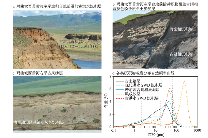 新窗口打开|下载原图ZIP|生成PPT
图5玛曲黄河河岸的古湖相与古洪水和风沙沉积物
注:图片由黄春长拍摄于2018年8月;OSL年龄数据来自文献[37]。
Fig.5Deposits of the palaeo-lake, palaeoflood and eolian process along the Yellow River within the Zoige Basin
图6
 新窗口打开|下载原图ZIP|生成PPT
图6若尔盖地区特殊的地表过程与现象
注:图片均由黄春长拍摄于2018年8月。
Fig.6Some special surface processes and landscapes over the Zoige region
若尔盖古湖泄流消失之后,在河道与沼泽湿地之外的湖底,松散沉积物大面积暴露。与此同时,黄河的贯通盆地形成大拐弯河道,来自上游的大洪水会在盆地内的广阔平原肆意泛滥,其悬移质泥沙在湖盆内沉积下来。由于高原强劲风力作用的改造,会形成风沙活动区和风成黄土堆积区[43,44,45]。沿着黄河河道内的高河漫滩地带,时常有裸露的风沙地和流动沙丘,在大草原面和岩丘的坡麓也常有斑状分布的流动沙丘和半固定沙丘,其为分选良好的细沙,粒径在100~250 μm之间,但是随着离开沙源距离增大,其平均粒径会明显地减小[41]。我们调查发现在黄河弯道凹岸的陡峭河岸剖面,常常会暴露出十分松散的风沙层和古沙丘,沙层坠落导致河岸持续地坍塌后退(图3d、图5c)。对于玛曲黄河两岸风沙地沙丘的OSL测年,显示若尔盖盆地在(10.27±0.18) ka就出现了广泛的风沙活动,盆地周边也有风成黄土的堆积[41]。这就从一个侧面证明了全新世初期若尔盖盆地的湖水就已经消失,干湖盆草原地面风沙活动盛行。
综合多方面的沉积学证据与测年断代结果,可以看出若尔盖古湖相淤泥层最晚年龄介于37~18 ka,而其上的各类覆盖层,如河漫滩沙、风成沙、古洪水沉积物、沼泽泥炭,以及反映东昆仑大断裂强烈活动的古地震,最早年龄在26~10 ka(表1)。虽然有****综合前人对若尔盖盆地地貌与环境变化及其沉积物测年结果,认为若尔盖盆地黄河古河道形成于晚更新世[40]。但是,就若尔盖古湖消亡与黄河贯通盆地的准确年龄问题,测年结果还是很分散的,仍然存在着很大的不确定性。
Tab.1
表1
表1若尔盖古湖消亡与黄河贯通的沉积学证据及年代对比
Tab.1
| 研究地点 | 沉积物性质/动物化石 | 发生年代 | 数据来源 |
|---|---|---|---|
| 黑河下游河岸剖面 | 古河漫滩相沙层出土原始牛化石 | 14C (26620±600) a BP | 文献[28] |
| 唐克杂威黄河右岸剖面 | 古河漫滩相沙层出土披毛犀化石 | 14C (22650±300) a BP | 文献[29] |
| 唐克郎哲岩丘坡脚黄河右岸剖面 | 古河流相沉积物 | TL (17460±1580)~ (11470±1030) a | 文献[19] |
| 玛曲县城黄河右岸阶地剖面 | 古河漫滩沼泽相沉积层 | 14C (12120±150) a BP | 文献[30] |
| 黑河下游沼泽RH钻孔岩芯剖面 | 古湖相与河流沉积物界限 | 14C (37630±1070) a BP | 文献[22] |
| 黑河下游沼泽DC剖面 | 古河漫滩沙层与青灰色古湖相淤泥层界限 | 14C (20340±550) a BP | 文献[24] |
| 黑河口黄河右岸剖面 | 古河流相与青灰色古湖相淤泥层界限 | 14C (18745±360) a BP | 文献[24] |
| 玛曲扎西塘南黄河岸剖面 | 灰黑色泥炭层(其上覆盖层有冻融褶皱) | 14C (14710±340) a BP | 文献[24] |
| 黑河下游沼泽RM钻孔岩芯剖面 | 古湖相与河流沉积物界限 | 14C (21600±1500) a BP | 文献[20] |
| 瓦切瓦松泥炭沼泽剖面 | 灰色湖相淤泥与泥炭层界限 | 14C (12180±90) a BP | 文献[31] |
| 玛曲县城黄河右岸阶地剖面 | 古河漫滩相粉沙质淤泥层 | 14C (21540±395) a BP | 文献[39] |
| 若尔盖黄河河岸剖面 | 古河流沉积物 | OSL-14C (12500±1200) a | 文献[40] |
| 瓦切日干桥泥炭沼泽剖面 | 古湖相沉积物与泥炭层界限 | 14C (12600±10) a BP | 文献[32] |
| 玛曲太吾若黄河左岸剖面 | 黄河古洪水滞流沉积层 | OSL (13590±1200) a | 文献[37] |
| 黑河下游古沙丘剖面 | 古风沙沉积层 | OSL (10270±180) a | 文献[41] |
| 玛曲城西南冰水扇—洪积扇探槽剖面 | 古地震地裂缝错断的古地面 | TL (22700±3100) a | 文献[42] |
新窗口打开|下载CSV
3 若尔盖古湖泄流与黄河贯通的成因机制问题
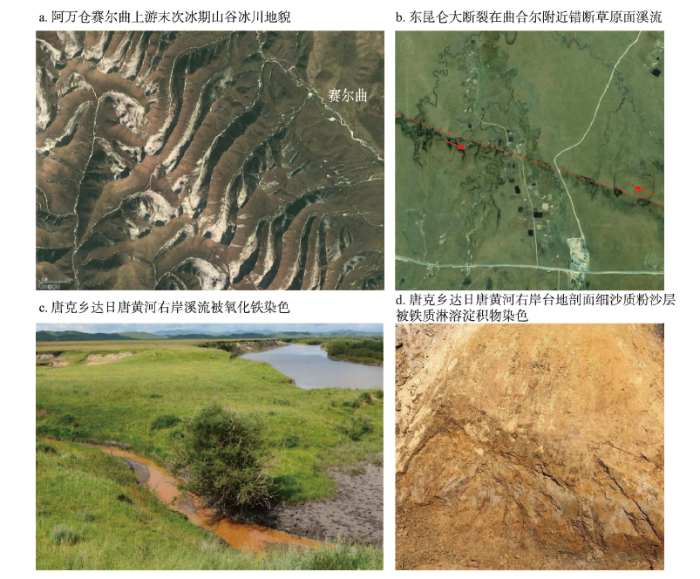
关于若尔盖古湖消亡与黄河贯通若尔盖盆地的机制问题,据认为在若尔盖古湖存在期间,周边水系如来自扎陵湖—鄂陵湖的古河流、贾曲、白河、黑河皆以若尔盖盆地为终点。在12 ka前,由于盆地下游古黄河源头水流沿着拉加峡溯源侵蚀向上伸展,原来沿着欧拉乡—玛曲县城断陷谷地自西北向东南流入若尔盖古湖的倒淌河(与现代黄河流向相反)被袭夺,致使古湖水外泄,黄河在古湖底形成大拐弯河道,与原属于若尔盖湖盆的水系沟通,将其纳入到了黄河水系[30]。对于若尔盖古湖盆钻孔岩芯沉积物分析研究,认为在38~25 ka前,处于盆地下游方向的古黄河源头水流强烈的溯源侵蚀,导致古湖盆被切穿,古湖水泄流消失[22]。也有****认为,在晚更新世末期,达日县以西包括鄂陵湖和扎陵湖在内的广大区域形成了面积巨大的冰水湖,由于东西向新构造断裂的活动,致使古湖水东流外泄,巨量的含沙水流进入若尔盖湖盆,导致若尔盖古湖水位大涨而向西北溢流外泄,切开了西倾山形成了玛曲—兴海之间曲折的基岩峡谷(拉加峡),从而沟通了整个黄河源区的水系[1]。目前,黄河从玛曲桥段西流出若尔盖盆地,流过玛曲县城—欧拉乡—柯生乡—欧拉秀玛乡之间长达90 km的断陷谷地草原。这道宽谷沿着东昆仑大断裂新构造活动带发育,沿途被出自于西倾山南坡和阿尼玛卿山北坡的冰水扇—洪积扇夹持,形成蜿蜒曲折的深切曲流。我们在该宽谷段的调查发现,在柯生乡西南末次冰期形成的冰水扇—洪积扇草原地面,这条NWW-SEE方向发育的左旋平移活动大断裂表现非常清楚。沿着大断裂形成了断续的线状分布的凹槽、洼地、泉眼、积水池沼和崖坎。尤其是在卡尔科—曲合尔村之间,草原面的溪流水系被持续性的平移错开,错距达到400~600 m(图6b)。根据地震地质学方面在玛曲县城西南侧冰水扇—洪积扇大草原面横跨主断裂带开挖出的探槽剖面,可知末次冰期以来沿着该断裂带曾经发生过若干次古地震,其中可以确认的是最早发生在(22.7±3.1) ka和(12.2±1.7) ka的古地震,明显地错断了由风成黄土覆盖冰水扇—洪积扇沙砾石层构成的古地面[42]。所以,不能排除这样的可能性,即在晚更新世晚期出自于阿尼玛卿山北坡的众多冰水河流(相当于现代曲合尔、当庆、当琼、西科河)在欧拉秀玛乡那浩若村附近汇聚,向西北流出拉加峡而构成黄河源头。在欧拉乡—柯生乡之间的断陷谷地段,由高大的冰水扇—洪积扇构成古分水岭。然而在22.7 ka或者12.2 ka前后,东昆仑大断裂强烈地震活动,严重破坏了这道分水岭(图2)。与此同时,原来入湖河流上源山地冰川大范围消融,大量冰融水充满了若尔盖盆地,古湖水通过玛曲桥段向西溢出泄流,从而逐渐地切断了欧拉乡—柯生乡之间的古分水岭,使得原来属于若尔盖湖盆的水系与下游水系相互沟通,形成大拐弯的河道,奠定了现代黄河源区水系的格局。
4 存在问题及最新进展与展望
综上所述,可知有关若尔盖盆地古湖消亡与黄河贯通盆地的年代问题,目前并无确切的结论。究其原因:① 已有研究地点多集中在泥炭沼泽和黑河、白河等支流沿岸,真正在盆地内沿着黄河首曲从采日玛—玛曲桥长达110 km两岸,在清楚暴露的河岸剖面,针对沉积物、沉积相及环境演变问题的研究是很少的,而测年数据则少之又少;② 对于湖相沉积物判别比较混乱,未能将黄河贯通之后干支流河道局部短时性浅洼地沉积物、牛轭湖沉积物等,与黄河贯通之前若尔盖古湖沉积物区分开来;③ 各方面对于代表古湖泊消亡与黄河贯通的沉积物测年断代结果,相互之间差异很大;④ 对于盆地内外黄河阶地及其级数的判断、以及黄河河床相、河漫滩相沉积物性质及其层位关系的判断各有不同;⑤ 钻孔岩芯沉积物可观察到的断面极其狭小,不利于判别各种沉积物的性质,以及河流冲积物与古湖相沉积物之间的不整合面,而这个不整合面是古湖消亡的重要标志;⑥ 调查发现,在若尔盖高原盆地,各种复杂地表过程相互交织,尤其是在若尔盖古湖泊消亡之后,黄河及其支流蜿蜒流动在盆地之内,沿河两岸形成了无数的牛轭湖,其沉积物分布散乱,加之古风沙作用改造等,使得各种沙质与粉砂质沉积物皆表现为复合成因,干扰着人们对于其原始沉积相和地表过程的判断;⑦ 在高原寒冷沼泽湿地环境之中,各种松散沉积层都受到了铁锰淋滤淀积等次生过程的严重影响,无论是在天然暴露的沉积物剖面,还是钻孔岩芯剖面,各种类型粘土质、粉砂质和沙质沉积物中都会出现密集的黄橙色锈斑,甚至被全面地染成亮黄橙色,失去了沉积物的原生色彩(图6c~6d),这些会严重干扰了人们对于沉积物性质、成因和沉积相的判别。我们从河流古洪水沉积学、年代学与水文学的角度,采用多学科交叉的技术路线和方法,在若尔盖盆地的野外调查当中,识别山麓坡积层、沟谷山洪沉积层、泥流泥石流沉积层、冰碛物与冰水沉积物、古风沙沉积层、风成黄土沉积层等,排除这些复杂地表过程以及高原冷湿环境中铁锰淋溶淀积等次生过程的影响,对照现代大洪水沉积物,准确鉴别早期黄河特大洪水发生过程当中形成的沉积物,尤其是悬移质泥沙高水位滞流沉积物和溢出河槽的泛滥洪水沉积物,采用多种方法测年断代,建立起河流古洪水沉积序列及其年代框架,确认若尔盖盆地范围内最早发生的黄河特大洪水事件。并且鉴别黄河古洪水沉积层与下伏古湖相沉积层之间的不整合面,获取古湖泊消亡与黄河贯通若尔盖盆地的直接证据。
就目前的研究结果来看,在黄河玛曲段两岸若干地点发现由古洪水沉积层记录的特大洪水事件,发生在OSL年龄(13.6±1.2)~(13.0±1.1) ka期间,其洪水主要来自于若尔盖盆地上游广泛分布的高山冰川的冰雪融水。由此证明在末次冰消期Bolling-Allerod全球性相对温暖阶段,黄河就已经穿过若尔盖盆地,流经玛曲—欧拉秀玛断陷谷地,并且发生了特大洪水事件。因此可以说古洪水水文学的研究,对于解决若尔盖古湖消亡与黄河贯通的年代问题,开辟了一个新的研究途径。
致谢:感谢查小春教授、周亚利副教授、张玉柱副教授、郭永强副研究员、尚瑞清副研究员和研究生陈莹璐、戎晓庆、炊郁达、王海燕、王娜等在野外考察和实验室样品处理与测试过程当中的鼎力相助。
参考文献 原文顺序
文献年度倒序
文中引用次数倒序
被引期刊影响因子
URL [本文引用: 2]

The lake basin area in the source of the Yellow River is a tectonic depression zone since Neozonic. During the Tertiary, there was a typical high peneplain with a lot of hills and lower mountains of 500~1000 m a.s.l. In those years, the climate was warm and humid. There were a lot of karst features appeared on the limestone massif and red debris deposits in the piedmont, with large paleolakes. Up to the end of the Tertiary, the plateau uplifted and the climate turned to cold, but it was still a bigger lake basin during the early Pleistocene, and in the Xixiabangma Glaciation, no glacier developed in these mountains because the snowline altitude was over the altitude of the mountains. During the Cahaxili Glaciation of the middle Pleistocene, there were glaciers developing in the Bayan Har, Zarijia, Buqingshan and Anyemaqen Mountains and four big ice caps with a diameter of about 30~50 km. Up to the late stage of the middle Pleistocene, penultimate glaciation, glaciers extended downward to valleys and Ngoring Lake was a large glaciofluvial lake. Some lakes such as Xinxinhai Lake on the north slope of the Mianshaling range also appeared. During the last glaciation of the late Pleistocene, medium valley glaciers developing in the mountains and the climate was cold and dry with strong wind. In Mianshaling area the eolian sand deposited largely and the glaciofluvial lakes shrank, because the lake water outflowed eastwards owing to neotectonic fault with a direction of east-west. The Yellow River system became connected together and a large of water with sand from lake area of the source of the Yellow River run into the Zoige Lake area. In the middle of the Holocene, lake area greatly shrank and large lake bench and valley plain with a dry grassland appeared, and meanders in the Yellow River were developing.
[本文引用: 2]
URL [本文引用: 1]
Lacustrine sediment of glacial lakes can not only record the history of regional environmental change,but also reflect glacial succession.The Nianbaoyuze Mountains is located in Jiuzhi County,Qinghai Province and Aba County,Sichuan Province in Eastern Tibetan Plateau.The forming time of moraine in this area has been studied extensively using various techniques,including 14C,CRN,OSL etc.The cosmogenic radionuclide(CRN)dating and optically stimulated luminescence(OSL)ages indicate that the Nigequ glaciation was formed during MIS 3 and the Ximen Co glaciation was formed during the Last Glacial Maximum.Yet this result contradicts with record from the Ximen Co core.The Ximen Co,located in the north part of the Nianbaoyuze Mountains,is a glacial lake which is formed after the glaciation retreated intensively in glacial stage.A continuous 12.80m long core at the water depth of 50m from the Ximen Co was obtained in 2004.There are ten AMS ages of the core,three of which at the bottom are converted.The dead carbon effect of the Ximen Co is 1300a.In this article we reconstruct the glacial succession and environmental change based on analysis of organic content,grain size,and magnetic susceptibility.Continuous lake sediment indicates that the lake have existed since 38kaB.P.and the glaciation did not exceed the modern lake during the existence of the lake.The lake sediment also indicates that Ximen Co existed during the LGM,which contradicts with the CRN dating of the Ximen Co glaciation.The reasons of the discrepancy between moraine dating and sediment are discussed.We believe that the CRN and TL datings of the moraine represent the age of ice retreating,not the age of glaciation.We thus conclude that the ages of the Nigequ glaciation and the Ximen Co glaciation are both beyond 38kaB.P.The moraine of LGM is probably in the south of the Ximen Co.The result also shows that many work about the glaciation in the LGM and MIS 3 need to be done further through lake sediments.
[本文引用: 1]
[本文引用: 1]
[本文引用: 1]
[本文引用: 2]
[本文引用: 2]
[本文引用: 2]
[本文引用: 2]
[本文引用: 2]
[本文引用: 2]
DOI:10.1016/S0031-0182(99)00032-2URL [本文引用: 2]
DOI:10.1016/S1464-1895(99)00119-2URL [本文引用: 1]
[本文引用: 1]
[本文引用: 1]
DOI:10.1016/j.aeolia.2015.02.002URL [本文引用: 1]
[本文引用: 1]
[本文引用: 1]
[本文引用: 1]
[本文引用: 1]
[本文引用: 1]
[本文引用: 1]
[本文引用: 2]
[本文引用: 2]
[本文引用: 1]
[本文引用: 1]
[本文引用: 1]
[本文引用: 1]
[D].
[本文引用: 1]
[D].
[本文引用: 1]
[本文引用: 1]
[本文引用: 1]
[本文引用: 3]
[本文引用: 3]
[本文引用: 2]
[本文引用: 2]
[本文引用: 1]
[本文引用: 1]
[本文引用: 3]
[本文引用: 3]
[本文引用: 1]
[本文引用: 1]
[本文引用: 5]
[本文引用: 5]
DOI:10.1016/j.quascirev.2016.08.005URL [本文引用: 1]
[本文引用: 1]
[本文引用: 1]
[本文引用: 1]
[本文引用: 1]
[本文引用: 2]
[本文引用: 2]
[本文引用: 2]
[本文引用: 2]
[本文引用: 6]
[本文引用: 6]
[本文引用: 2]
[本文引用: 2]
DOI:10.1016/j.quascirev.2014.05.003URL [本文引用: 2]
Most studies about carbon dynamics of peatlands have been focused on boreal, subarctic and tropical peatlands. However, there is limited data about carbon dynamics of alpine peatlands, like Zoige peatlands on the Qinghai-Tibetan Plateau (QTP), which are sensitive to climate change and human disturbance. We studied the role of these peat deposits on the Zoige as a C reserve and sink by measuring peat depth, radiocarbon age and peat and C accumulation rates at 7 sites. The peat depths of the sample sites ranged from 0.20 to 6.0 m; the basal age on the plateau varied from 1635 to 14095 cal yr BP; the peat accumulation rates ranged from 0.12 to 0.85 mm yr(-1), and the C accumulation rates from 5 to 48 g m(-2) yr(-1). Based on data of field studies and remote sensing, we regarded that with 3179 km(2) of intact peatlands, about 1426 km(2) of degraded peatlands, and the total area of Zoige peatlands was 4605 km(2). The current peat C stock of Zoige peatlands was0.477 Pg (ranging from 0.206 to 0.672 Pg). We also estimated that peatlands covered an area of about 5091 krn(2)on the QTP and sequestered 0.543 Pg C, 88% in Zoige and the rest in other parts of the plateau. Human activities, together with the ubiquitous warming on the plateau (temperature increased by 0.2 degrees C per decade over the past 50 years) not only shrank the area of intact peatlands, but also caused substantial carbon releasing from peatlands. (C) 2014 Elsevier Ltd.
[本文引用: 1]
[本文引用: 1]
DOI:10.1016/j.palaeo.2010.02.003URL [本文引用: 1]
[本文引用: 1]
[本文引用: 1]
DOI:10.1016/j.quaint.2019.06.023URL [本文引用: 1]
[本文引用: 3]
[本文引用: 3]
[D].
[本文引用: 1]
[D].
[本文引用: 1]
URL [本文引用: 1]
The upper reaches of the Huanghe (Yellow) River,a length of 1350 km from Gyaring Lake to Guide county,cuts through the great slope of the northeast part of the Qinghai-Xizang (Tibet) Plateau and it runs through a few of Mesozoic-Cenozoic depositional basins,for example,Guide basin,Gonghe basin,Xinghai basin,Zoige basin,Ngoring-Gyaring basin etc.,the sections between them are a series of gorges of the Huanghe River.Based on author’s investigation,there is a terrace of 7 steps in the Huanghe River valley by Guide county,a terrace of 3 steps being formed by the ancient Huanghe River and 7 steps in Gonghe basin,6 steps by Gamao Yangqu town,5 steps by Tangnaihai town,Xinghai County,3 steps by Maqu town,Gansu Province,and one step by Ngoring-Gyaring Lake.The overall upper reaches of the Huanghe River was linked up by a series of the stream captures occurred after strongly uplifting of the Qinghai-Xizang area into a plateau.A section of the ancient Huanghe River through the place Gahaitan located on northeastern Gonghe basin towards east into Guide basin was developed during the end of Middle Pleistocene to the middle of the Late Pleistocene,and then it migrated towards southeast to the place Longyangxia Gorge about 60000 years ago.And the gorge from Maqu to Tangnaihai was linked up about 20000 years ago.
[本文引用: 1]
[本文引用: 2]
[本文引用: 2]
DOI:10.1016/j.catena.2017.10.005URL [本文引用: 3]
[本文引用: 2]
[本文引用: 2]
DOI:10.1007/s12665-009-0155-9URL [本文引用: 1]
Studies and efforts to control aeolian desertification in China have focused on the arid and semiarid lands in the north. However, the aeolian desertification that is occurring on the high-altitude Qinghai–Tibetan Plateau, which has a cold and humid climate, has received attention only in recent years. In this paper, we report the results of monitoring this aeolian desertification between 1975 and 2005 and of our analysis of its causes on the Zoige Plateau, which is located in the northeastern part of China’s Qinghai–Tibetan Plateau. Aeolian desertified lands expanded at a compound annual rate of 4.07% between 1975 and 2005. They expanded most rapidly between 1975 and 1990, at an annual rate of 7.73%. Factors responsible for this expansion include increasing temperature, decreasing precipitation, over-grazing, drainage of water systems, and land reclamation for agriculture. Increasing temperature, over-grazing, and the drainage of water systems were the key factors. The climatic variations between 1975 and 2005 were not sufficient by themselves to lead to aeolian desertification. Human disturbances such as over-grazing and drainage of water systems must thus have been primarily responsible for the observed changes, and human behavior must be adjusted to control the expansion of aeolian desertification and rehabilitate the desertified lands.]]>
DOI:10.3799/dqkx.2010.007URL [本文引用: 1]
[本文引用: 1]
DOI:10.1016/j.quaint.2019.03.018URL [本文引用: 1]
