 ,2, 刘可文3, 梁双波4,5, 钱超峰11.
 2.
3.
4.
5.
Spatial evolution of Eurasian land and sea transport accessibility from the historical perspective
LI Luqi1, WU Qiyan,2, LIU Kewen3, LIANG Shuangbo4,5, QIAN Chaofeng11. 2.
3.
4.
5.
通讯作者:
收稿日期:2018-03-26修回日期:2019-12-1网络出版日期:2020-04-25
| 基金资助: |
Received:2018-03-26Revised:2019-12-1Online:2020-04-25
| Fund supported: |
作者简介 About authors
李鲁奇(1991-),男,山东泰安人,博士生,研究方向为城市网络与区域治理E-mail:liluqi@outlook.com。

摘要
关键词:
Abstract
Keywords:
PDF (6536KB)元数据多维度评价相关文章导出EndNote|Ris|Bibtex收藏本文
本文引用格式
李鲁奇, 吴启焰, 刘可文, 梁双波, 钱超峰. 历史视角下亚欧大陆海陆交通可达性空间格局演化. 地理学报[J], 2020, 75(4): 804-819 doi:10.11821/dlxb202004010
LI Luqi.
1 引言
亚欧大陆是世界政治舞台的中心,在全球地缘格局中始终具有关键地位[1]。由于中国的战略利益和战略辐射主要集中于亚欧大陆,因而它也成为“一带一路”倡议所覆盖的主要地区和中国全球战略所率先部署的地区[2]。自2013年“一带一路”倡议提出以来,国内外****就该倡议对亚欧大陆政治经济格局的重构进行了广泛探讨。国外研究多关注地缘政治[3]、跨境旅游[4]、环境保护[5]等方面,其中,欧洲、西亚和南亚等局部地区对“一带一路”的响应[6,7]成为研究焦点。国内研究主要关注宏观战略和具体建设两个层面,前者侧重分析“一带一路”的内涵[8]、地缘政治效应[2, 9]、空间响应和开发[10,11]等,后者则涉及城市空间扩张与自然资源利用[12]等一系列问题。“一带一路”以基础设施的互联互通为优先领域和合作重点,故其对亚欧大陆交通格局的影响以及相关的交通合作、路线优化等问题亦受到广泛关注。国外研究主要关注陆运路线优化、海运路线和港口群优化、多式联运网络优化以及交通改善所带来的地区发展效应等方面[13,14,15]。国内研究尤其是地理学领域更偏重于空间格局分析,主要涉及陆运交通、海运交通、海陆联运、航空运输以及沿线地区贸易网络等。其中在铁路、公路等陆运交通方面,既涉及“一带一路”全局的交通可达性[16]和溢出效应[17],也涉及东亚[18]、中亚[19]、西亚[20]、欧洲[21]、中南半岛[22]等沿线局部地区的交通格局和交通合作,此外国内“一带一路”沿线地区的交通优势度[23]等问题也受到关注。海运交通具有更为明显的网络化形态,因此相关研究多基于港口节点或航运网络探讨枢纽或支点港口的选择[24]、港口间网络的格局及演化[25]等。在其它交通方式方面,相关研究主要涉及海陆运输平衡线划分[26]、对外航空运输联系[27]、铁路与航空客运的比较[28]、集装箱多式联运[29]等。此外,交通基础设施建设的国际经贸效应和经贸网络格局[30,31]等亦受到广泛关注。
不过,从整体上看,当前研究多侧重于共时性分析,较少关注“一带一路”沿线亚欧大陆交通格局的历史演化;其中涉及空间演化的历时性研究[18, 25, 30]通常仅关注近几十年,缺乏对较长历史时期的宏观分析;而基于较长时间尺度的研究则主要侧重于对古代丝绸之路发展历程的考察[32,33],缺乏对交通可达性演变的定量刻画。然而,“一带一路”与古代丝绸之路一脉相承,该倡议在整个人类文明发展史上也占据重要地位[34],若缺乏对沿线交通格局演化过程和趋势的“历时性、长时段、定量化”分析,将难以全面地认识“一带一路”倡议的历史角色,也难以调整保障这一倡议的长期稳定实施所依赖的宏观战略部署。
在此背景下,本文在时间上将选取古代、近代、现代和当代,对亚欧大陆陆运交通和海运交通可达性的空间格局演化过程和趋势进行初步分析,并在此基础上简要探讨历史趋势下“一带一路”倡议的地位和部署,以期为相关研究提供一定借鉴。
2 研究区、研究方法与数据来源
2.1 研究区概况
亚欧大陆包括亚洲和欧洲,在人类文明演进和地缘政治格局中占据核心地位。其内部各文明间的交流伴随着交通工具和基础设施的发展以及各文明自身的发展而逐步扩大,其中陆上和海上丝绸之路在古代发挥了关键作用。近代以来,亚欧大陆的陆运和海运交通网络日益完善,进一步加深了各文明间的经济贸易往来,并重构了亚欧大陆的地缘政治和经济格局。在研究区范围上,考虑到各交通方式的特点,陆运交通部分将仅分析除周边岛屿以外的大陆地区,海运交通部分则包含亚欧大陆全部空间范围。2.2 研究方法
为整体把握亚欧大陆交通格局的历史演化,并使之与古代丝绸之路和“一带一路”倡议相对应,本文将关注陆运和海运两种交通方式。由于海陆联运在20世纪才迅速发展起来,而二者在历史上始终并行发展、相互替代转换[11],因此将对两类交通方式分别进行探讨,而非建立综合的海陆交通指标。基于世界史分期,并结合数据资料的时间跨度,本文将时段划分为古代、近代、现代和当代。其中,古代设定为BC 50—AD 1640,尽管该阶段时间跨度较大,但以农业文明为主,生产力发展相对缓慢,区域间交通的路线、规模等也相对稳定。近代设定为AD 1640—1917,该阶段处于地理大发现、两次工业革命和欧洲资产阶级革命时期,伴随生产力和资本主义生产关系的发展,区域间海陆交通也迅速发展起来。现代设定为AD 1917—2017,其中AD 1950—2017亦可称为当代。该时期全球化深入发展,现代化进程和革命运动也在世界各地开展起来,其中20世纪50年代后,第三次科技革命进一步推动了生产力的迅速发展,区域间联系的规模和强度也迅速提高。考虑到数据资料的限制,在陆运部分将现代设定为AD 1917—1950,采用与古代、近代相同的指标和方法,以分析陆运交通的历史演化;当代则结合最新数据,细致刻画国家边界影响下陆运交通可达性的现状格局。在海运交通中,受数据限制,将不对现代和当代进行区分。
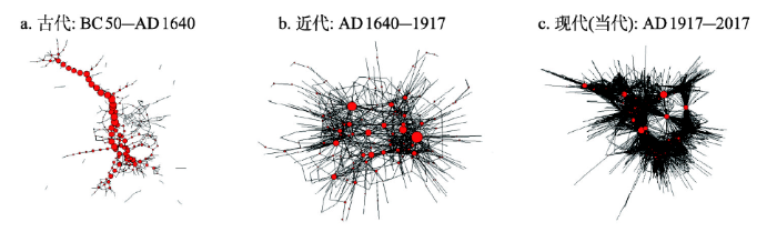
由于各阶段时间跨度较大,故假设交通网络在历史上持续向密集化方向发展[35],据此可分别对各阶段内不同年份的数据取并集,得到该阶段末的交通网络结构(图1),并以阶段末的陆运交通速度对其进行赋值。在此基础上,基于以下方法对海陆交通进行分析。
图1
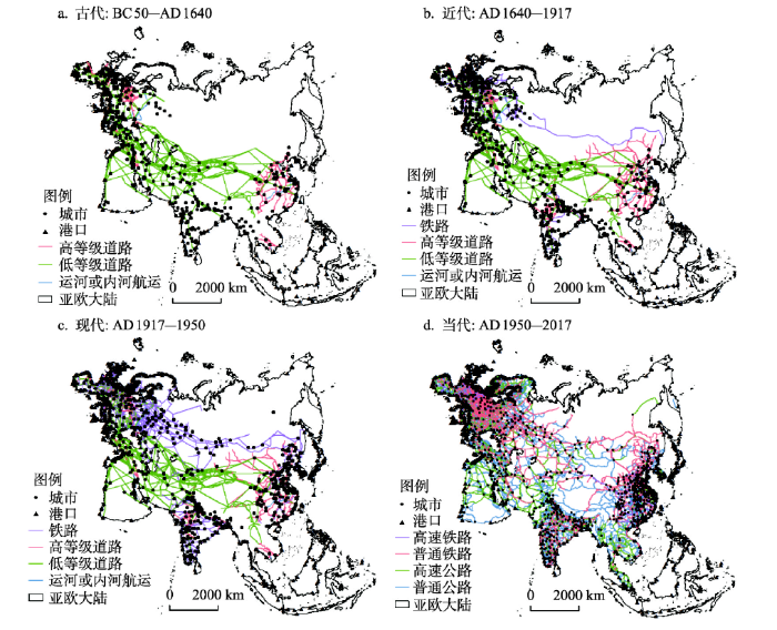 新窗口打开|下载原图ZIP|生成PPT
图1亚欧大陆各时期交通网络
Fig. 1Transport networks on Eurasia in each historical period
2.2.1 陆运交通可达性指标 借鉴已有研究[36,37,38],本文将基于各时期城市间OD成本矩阵计算其可达性。受数据获取的限制,将结合各类资料对各时期交通速度进行估算:低等级道路在古代、近代、现代分别赋值为5 km/h、5 km/h、30 km/h①(①古代参考人的步行速度和马驮物速度进行赋值,请参见:李光耀, 杨丽. 城市发展的数据逻辑. 上海: 上海科学技术出版社, 2015; 王铁权. 情系马学五十年: 王铁权先生作品选编. 北京: 中国农业科学技术出版社, 2012。近代尽管已出现汽车,但多行驶于条件较好的马路上,而从整个亚欧大陆来看,条件较差的低等级道路仍以步行和马驮物为主。现代则参考二十世纪中叶市内道路的速度,请参见:Speed limit signs: A history of speeding in the US. https://www.roadtrafficsigns.com/speed-limit-signs-history. 2018-07-24.);高等级道路分别赋值为7.5 km/h、30 km/h、55 km/h②(②古代参考马车速度,请参见:王铁权. 情系马学五十年: 王铁权先生作品选编. 北京: 中国农业科学技术出版社, 2012. 近代请参见:History of the automobile.
式中:Tij为同一时期亚欧大陆城市i、j间的最短旅行时间;n为该时期亚欧大陆的城市数量。
等时圈分析基于成本栅格进行计算,像元大小为10 km×10 km,通行速度与上文一致。为避免因城市数量变动而造成的空间格局差异,并考虑到城市发展在数量和规模上呈整体上升趋势,故均基于古代城市对各时期等时圈进行分析。
此外,在这一跨界交通研究中应充分考虑国家边界因素的影响,但该思路在历史分析中面临诸多障碍:首先,国家边界在历史上变动频繁,若基于某一时刻的边界分析整个时段则有失严谨;其次,“边界”是主权意识兴起后的产物,而古代多以“边疆”划分国家领土[39],因此对古代边界的划分带有一定推测成分;最后,受数据限制,古代边界效应的测度也难以选取合适的方法。而从整体上看,在历史上陆运交通受自然条件的制约更为明显,而国家边界的影响伴随经济技术条件的改善才进一步凸显出来。因此在历史演化分析中,本文将仅考虑高程、坡度等地形因素的制约;为保证指标的一致性,现代陆运交通也仅考虑地形因素。
当代交通受“边界效应”的影响更为明显,数据资料也较为丰富。因此,一方面基于小尺度交通地图,断开实际并未联通或未开放口岸、检查站的跨境交通线;另一方面借助国际贸易量估计各国“边界效应”[40]。建立如下边界效应模型:
式中:tradeij为i地区向j地区的出口贸易量;domestic为虚拟变量,当i = j时取1,反之取0,其系数?的指数形式e?即为边界效应;gdpi、gdpj分别为i地区和j地区的国内生产总值;dij为两地区首都间的交通距离,地区内交通距离[41]则为
式中:集合D为国内城市;集合F为国外城市;Tij和Tik分别为城市i、j间和城市i、k间的最短旅行时间;m和n分别为国内和国外城市数量。由于边界效应表示国内贸易对国外贸易的倍数,而可达性是一个负向指标,因此将各城市与国外城市的可达性定义为
2.2.2 海运交通可达性指标 陆地城市的海运交通可达性受多种因素影响,如城市与出海港口之间的距离、港口自身的可达性等。在此考虑到数据限制和各阶段间指标的一致性,将陆地上某一点i的经济潜能可达性定义如下:
式中:ω为船舶运力权重,用于反映不同历史阶段船舶运载能力的差别⑤(⑤受数据限制,在此使用各时期船舶最大吨位数据,并将古代设定为1后进行标准化。船舶吨位数据请参见:费尔南·布罗代尔. 菲利普二世时代的地中海和地中海世界(第一卷). 北京: 商务印书馆, 2009; List of largest passenger ships. https://en.wikipedia.org/wiki/List_of_largest_passenger_ships. 2018-7-25/2018-9-5.);Mj为港口j的质量,由于无法获得港口间实际贸易数据,故在此借助社会网络分析,以港口j的节点度表示;dij为点i与港口j之间的距离;n为对点i产生辐射的港口数量。该式的意义为距离节点度越高的港口越近,则陆上点i的海运交通可达性越好。
由于并非所有港口都能对陆上点i产生足够强烈的影响,因此需划定港口j的影响半径rj,只有当点i落在港口j的影响范围内(即dij < rj)时,才能受到其辐射。在此假设节点度越高的港口辐射范围也越大,则rj可定义为:
式中:
2.2.3 社会网络分析 为进一步分析城市间和港口间联系的结构与演化,将借助社会网络分析方法对其进行刻画。其中,中间中心度指一个节点在多大程度上作为其他节点的中介;节点度表示与某一节点存在直接联系的节点数量;平均最短路径指网络中任意两点间最短路径之和与所有可能的边之和的比值;直径指网络中任意两节点间距离的最大值。
2.3 数据来源
在陆运交通方面,古代道路数据、近代和现代非铁路道路数据主要来自旧世界贸易路线项目(Old World Trade Routes Project, OWTRAD)。近代铁路根据芝加哥大学图书馆数据库(当代高速铁路和高速公路速度主要来自各国交通地图和OpenRailwayMap网站。国外高速铁路站点根据各国交通地图进行绘制,国内则根据火车票网(
在海运交通方面,古代港口网络主要来自OWTRAD项目,共包含全球港口386个。近代主要来自世界海洋气象数据库(Climatological Database for the World's Oceans, CLIWOC),并结合网络资料进行补充,得到全球港口共748个。当代由于海洋航运的巨大发展,几乎任意港口间都可能存在直接联系,为保证各时期指标的一致性,在此将使用美国国家地理空间情报局发布的《港口间距离》(Distance between Ports)报告,共包含全球港口1333个。
3 陆运交通可达性的空间格局演化
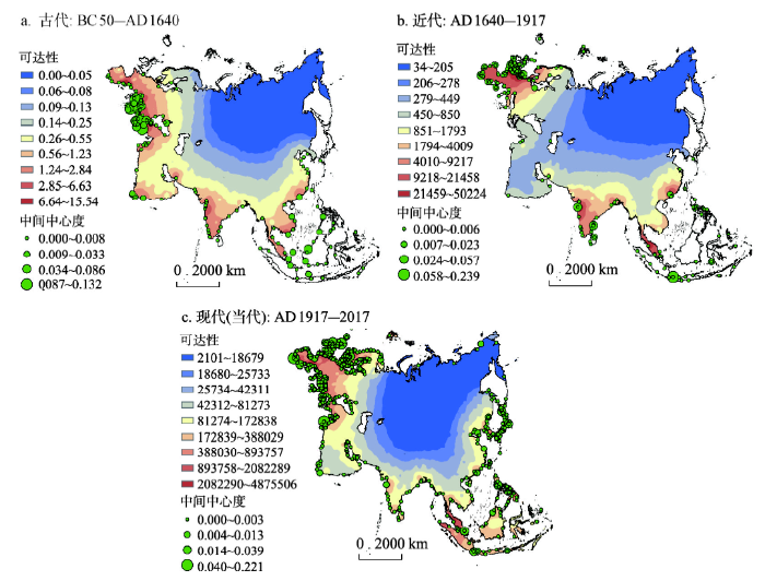
基于以上方法和数据,将从全局可达性、局部等时圈和城市网络三方面简要分析亚欧大陆陆运交通可达性的空间格局演化。3.1 全局可达性的历史演化与现状格局
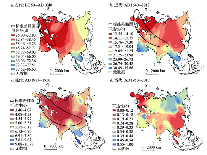
根据OD成本矩阵计算城市可达性,并基于1个标准差(包含68%的数据)绘制标准差椭圆,以分析可达性优于均值的节点在空间分布上的演化趋势;同时结合当代国家间边界效应,测算陆运交通可达性的现状格局(图2)。图2
 新窗口打开|下载原图ZIP|生成PPT
图2亚欧大陆陆运交通可达性的历史演化与现状格局
Fig. 2Historical evolution and current pattern of Eurasian land transport accessibility
古代城市主要分布于亚欧大陆南缘,贸易网络横贯大陆东西两端,但受自然条件、人口分布的影响,大陆中心地带多以无明确标识的低等级道路为主,而高等级道路则分布于东亚、西亚、西欧等地区。可达性在东西向呈核心—边缘结构,其中黑海和里海周边地区得益于在东西方交往中的枢纽位置,处于可达性较高的核心区,而东亚、南亚等地区则处于边缘区。相应地,可达性优于均值的城市也大致呈带状集中于大陆西南缘,尤其是西亚、东欧等地区。此外,在等值线形态上,由核心区至南亚、东亚等形成明显谷地,表明该地区交通设施较为发达,如由中亚经丝绸之路延伸至中国东部地区的谷地。
近代伴随生产力的发展和人口增长,城市分布在西欧、南亚等地区开始呈现明显的集聚特征。同时,伴随工业革命和殖民活动的发展,西欧、南亚等地区的铁路网络逐渐成形,俄国西伯利亚铁路的修建也连接了大陆东西两端。在此背景下,近代可达性呈现明显的双核心结构,二者分别位于大陆东西两端而非地理中心。可达性优于均值的城市也进一步向东西两端延伸。其中,得益于工业革命时期欧洲的铁路网建设,大陆西部可达性小于14.10 d的核心区基本覆盖整个欧洲。东部的核心区主要位于中国北部等地区,由于该地区尚未形成较为发达的铁路网络,故可达性仅处于第二级别。这一核心区的形成深受1891年所修建的西伯利亚铁路的影响,该铁路作为连接欧洲与东北亚的大动脉,提高了东亚地区的可达性,重构了当时的地缘政治格局,为沙俄向中国的殖民扩张提供了便利,甚至成为1904年日俄战争的导火索。
现代城市数量大幅度增加,集聚分布特征也更为明显,城市分布密集区主要位于印度、中国、西欧。同时,得益于铁路技术的进一步发展以及苏联建国后的社会主义建设,在整个欧洲已形成较为成熟的铁路网络;此外,东亚、南亚等地区的铁路网络也得到不同程度的发展。在此背景下,可达性小于4.07 d的核心区重新向亚欧大陆的地理中心移动,小于4.53 d的核心区则在东亚形成狭长谷地,并基本横贯大陆东西部。相应地,可达性优于均值的城市在空间分布上也持续向东亚地区延伸。
总体上看,在历史演化上,陆运交通核心区呈现向东部扩展的趋势,即由古代的单一核心区演化出近代“飞地式”扩展下的东亚次级核心,进而在现代相互融合并再次形成横贯东西的核心区;可达性优于均值的城市也相应向大陆东部持续延伸。此外,该过程也体现了交通线和地理位置在影响区域可达性中的交互作用,即在古代交通线的分布、级别在空间中差别不大时,核心区趋向大陆地理中心,近代交通的不均衡发展则使核心区偏离地理中心,而现代得益于跨国交通网络的进一步完善,中亚等地理中心的优势又重新显现。
第二次世界大战结束以来,亚欧大陆的陆运交通获得进一步发展。一方面,各国在二战后开展了较大规模的基础设施建设,国家间经济社会联系也日益加深,由此形成了较为完善的跨国多模式陆运交通网络;另一方面,汽车、火车等交通工具的性能不断改善,高速铁路等新的交通方式也逐渐兴起。此外,伴随着技术的进步,自然条件对陆运交通可达性的制约逐渐减弱,而国家边界等社会政治因素的影响则日益凸显。在这些背景下,基于铁路和公路交通网络并加入边界效应因素,可发现当代交通可达性再次呈现双核心特征,两个核心分别位于西欧和东亚大陆东西两端;而在二者之间,则形成横贯中亚、西亚并连接南亚的带状相对优势区,这同“一带一路”倡议下“中国—中亚—西亚经济走廊”的走向基本一致,在连接东西两个核心区中具有突出潜力。
3.2 局部等时圈的历史演化
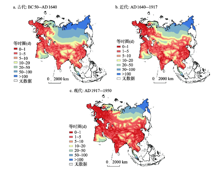
基于成本栅格和地形数据计算不同时期各城市的等时圈,并依据1 d、5 d、10 d、20 d、50 d、100 d划分时间段(图3),以分析陆运交通局部格局的演化。图3
 新窗口打开|下载原图ZIP|生成PPT
图3亚欧大陆陆运交通等时圈的历史演化
Fig. 3Historical evolution of Eurasian land transport isochronous rings
等时圈整体上呈现“点—线—网(面)”的演化形态。古代1 d等时圈主要为点状,而在东亚、西亚西部、西欧等地区初步呈现网状格局,但仍处于演化的初级阶段,各地区间并不联通。5 d等时圈在区域间基本相互联通,并形成欧洲、西亚—中亚—南亚和东亚3个主要集群。近代伴随交通工具和交通网络的发展,1 d等时圈沿交通线明显扩展,在东亚、南亚等地区均形成明显网状结构,西欧甚至由网络状演化为面状。5 d等时圈范围亦相应扩展,在大陆北部沿西伯利亚铁路呈线状自西向东延伸,20 d、50 d、100 d等值线也随之北移。在此趋势下,现代等时圈格局发生更为明显的变动。1 d等时圈形成覆盖大陆大部分地区的网络,其中欧洲、东亚、南亚等地区发育程度较高,中亚地区原有的点状结构也演化为网状。整体上看,1 d和5 d等时圈范围稳步扩展,而10 d以上等时圈范围则持续降低(表1),表明城市间联通程度不断提高,局部陆运交通联系日益密切。此外,从等时圈的扩展方式来看,整体上呈现由点状发育,到线状延伸,再到网状或面状生长的形态。
Tab. 1
表1
表1各时期等时圈面积及其变化率
Tab. 1
| 等时圈(d) | 古代(km2) | 近代(km2) | 现代(km2) | 近代变化率(%) | 现代变化率(%) |
|---|---|---|---|---|---|
| 0~1 | 3736700 | 7058700 | 14180100 | 88.90 | 100.89 |
| 1~5 | 6778700 | 16124900 | 19830300 | 137.88 | 22.98 |
| 5~10 | 8200000 | 10502100 | 7338800 | 28.07 | -30.12 |
| 10~20 | 9383500 | 7978000 | 5329400 | -14.98 | -33.20 |
| 20~50 | 9925300 | 9654100 | 7171800 | -2.73 | -25.71 |
| 50~100 | 10647300 | 8096700 | 6115300 | -23.96 | -24.47 |
| > 100 | 14732800 | 3989800 | 3438600 | -72.92 | -13.82 |
新窗口打开|下载CSV
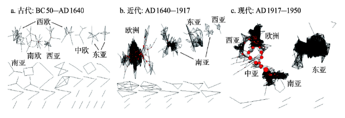
3.3 城市网络的历史演化
以24 h为间断点对城市间OD成本矩阵进行二值化(图4)。古代网络联通程度较低,共包含37个相互分离的子图,发育较好的子图主要分散在西欧、南欧、西亚、东亚等地区。近代形态与古代类似,包含23个子图,但出现明显的集聚趋势。其中得益于相对发达的交通网络,规模最大的欧洲子图包含201个节点;而南亚和东亚子图分别包含73和53个节点,其余均不超过20个节点。此外该时期中间中心势为0.024,相比于古代的0.005明显上升,表明各城市在枢纽功能上的层级分化趋于明显。现代交通的巨大发展使联通程度进一步提高,中间中心势急剧上升至0.202,子图数量也降低为9个。其中规模最大的子图包含407个节点,覆盖欧洲、西亚、中亚、南亚等地区,城市间的不均衡性也更为突出,其中喀布尔、德黑兰、阿什哈巴德、杜尚别等城市中间中心度均在0.1以上。规模第二的子图包含171个节点,多分布于东亚地区,各节点间的分化相对不明显。整体来看,城市网络的演化呈现由分散到集中的趋势,少数城市的枢纽作用也随之凸显,同时城市网络始终以区域为单元呈团聚状演化,表明区位和距离因素始终发挥重要作用。图4
 新窗口打开|下载原图ZIP|生成PPT
图4亚欧大陆陆运交通城市网络的历史演化
Fig. 4Historical evolution of Eurasian urban network based on land transport
4 海运交通可达性的空间格局演化
Mahan将海洋视为“伟大的高速公路”[42],其灵活性使世界各地能够被更紧密地联系起来。由于世界航运体系是一个整体,因此该部分将首先对全球港口网络的演化进行分析,随后进一步探讨亚欧大陆海运可达性的演化。4.1 全球港口间网络形态及其演化
港口间网络呈现由分散到集中的趋势(图5)。其中,古代网络整体上呈串珠状分布,主要沿亚欧大陆南缘连接西欧和东亚,原因在于古代航运技术相对落后,较难进行大范围的远洋航行,需依赖沿岸港口进行补给,其中西欧地区港口的网络状格局更为明显,航运体系相对发达。此外,古代也存在一定数量的孤立子图,表明港口间联通程度仍处于较低水平。近代伴随地理大发现和跨国贸易的迅速发展,世界航运联系开始朝向更为明显的网络化方向发展,连接数量明显上升,核心—边缘结构也逐渐显现,部分港口的枢纽功能开始凸显。这一趋势在现代(当代)更为显著,伴随全球航运体系的一体化,港口间联系更为密集、紧凑,同时直布罗陀海峡、巴拿马运河、好望角等少数中转枢纽成为全球航运网络的咽喉,战略位置极为重要。图5
 新窗口打开|下载原图ZIP|生成PPT
图5全球港口间网络形态及其演化
Fig. 5Pattern and evolution of global port network
从网络规模上看,各时期节点数量和连接数均持续增加,其中连接数的增长速度显著高于节点数量,两阶段增长倍率分别为3.14和13.79。各时期平均节点度也持续上升,其中现代(当代)平均节点度为前一时期的7.74倍,表明各港口进一步嵌入全球航运网络中。从联通水平上看,港口间平均最短路径持续降低,其中古代两港口间平均需经12.54步才可连接,近代降至3.81,现代(当代)则进一步降至3.17。在网络直径上,两个可联通港口间的最短距离也由37迅速降至8。总之,各时期全球港口间网络规模和联通水平呈现持续上升趋势(表2),表明地区间航运联系日趋密切。
Tab. 2
表2
表2各时期港口间航运网络的主要指标
Tab. 2
| 指标 | 古代 | 近代 | 现代(当代) |
|---|---|---|---|
| 节点数 | 386 | 748 | 1333 |
| 连接数 | 469 | 1473 | 20316 |
| 平均节点度 | 2.43 | 3.94 | 30.48 |
| 平均最短路径 | 12.54 | 3.81 | 3.17 |
| 直径 | 37 | 11 | 8 |
新窗口打开|下载CSV
4.2 海运可达性空间格局及其演化
港口具有出海门户和转运枢纽两个重要功能。当作为出海门户时,对陆地可达性具有辐射作用;当作为转运枢纽时,则主要服务于全球航运网络。据此计算各时期陆地城市的海运可达性和港口的中间中心度,以进一步分析海运可达性的演化特征(图6)。图6
 新窗口打开|下载原图ZIP|生成PPT
图6亚欧大陆海运交通可达性空间格局及其演化
Fig. 6Pattern and evolution of Eurasian sea transport accessibility
陆地海运可达性在总体水平上持续上升,在空间格局上呈现低水平相对均衡、相对集中、高水平相对均衡的演化过程。古代可达性整体水平较低,各地区均在15.54以下,平均值为0.46(图6a);其中可达性相对较高的地区贯穿大陆南部边缘,形成相对均匀的条带状格局;重要转运枢纽则主要集中于地中海北部和南海周边,表明该时期航运联系主要集中于东西方内部。近代由于技术进步(尤其是集装箱运输技术的产生)和区域间交流的扩大,可达性水平迅速增加,各地区均处于34~50224之间(图6b);同时伴随殖民扩张和跨国贸易的发展,可达性分布也呈现一定的集中趋势,西欧、南亚殖民地等成为核心区,东南亚和东亚部分地区可达性也相对较高。同时,欧洲重要的转运枢纽由地中海沿岸转移至西部和北部的西班牙、英国、荷兰等地区,而在南亚、东南亚和东亚南部等地区,少数枢纽的中转作用也开始凸显。现代(当代)由于集装箱运输技术的进步和全球化的深入发展,可达性水平加速上升,各地区均处于2101~4875506之间(图6c);同时陆地海运可达性也呈现一定的均衡化趋势,可达性较高的地区呈带状广泛分布于除北冰洋沿岸以外的大陆边缘,但欧洲仍居首位;重要转运枢纽在大陆尺度上的分布也趋于均衡化,但在区域尺度上日益集中于各海峡、海岬和运河等咽喉地区。
5 在历史趋势中认识“一带一路”倡议
“一带一路”倡议与古代丝绸之路一脉相承,并具有深刻的现实背景。因此,将该倡议置于亚欧大陆交通格局演化的历史趋势中,能够更为准确地把握其历史角色和战略部署。该部分将基于以上研究结果,对此进行简要探讨。首先,应从更长时间尺度出发,认识“一带一路”倡议在进一步推动文明间交流中的宏观历史意义。尽管该倡议有时仅被视为中国对周边施加影响的地缘政治策略[3]或区域发展战略[8],但从亚欧大陆交通演化过程来看,它具有更为宏观的历史背景和意义。区域间联通程度的改善是亚欧大陆交通演化的突出特点,在此过程中,区域间社会经济交流也相应趋向深化。然而,这一趋势当前仍受到边界效应的阻碍。在此背景下,进一步打破隔离、深化区域间交流的“世界主义”而非“孤立主义”成为历史发展的必然趋势和迫切需求,而“一带一路”倡议正以世界主义为价值目标[34]、以跨边界基础设施合作为重要形式,是推动各文明由封闭进一步走向包容开放的新方案,顺应了人类历史发展的整体趋势。
其次,海陆交通格局在大洲尺度扩散效应突出,这与地缘格局的多极化趋势相一致,在此背景下,“一带一路”倡议应坚持去中心化、平等包容的合作策略。近代欧洲工业革命的迅速发展打破了亚欧大陆原有的交通和地缘格局,使交通可达性演化呈现明显的不均衡化特征,如西伯利亚铁路所带动的陆运交通核心区飞地式扩展,以及南亚和东南亚殖民地海运交通可达性的迅速提高。不过,伴随交通网络的进一步完善、经贸合作的深化以及世界殖民体系的瓦解,现代(当代)海陆交通在全局上呈现明显的均衡化趋势,地缘格局也相应向多极化方向发展。在此背景下,“一带一路”倡议应更明显地体现去中心化特征,倡导“包容性全球化”[43]的思想,充分利用各地区差异化的发展基础和发展诉求,引导各国自发、平等地参与合作建设,探索多元的发展道路。
再次,充分利用和培育中亚、西亚等陆上战略支点,以及东南亚、苏伊士运河等多尺度的海上战略支点。在局部上,关键节点在现代(当代)海陆交通中地位凸显,承担重要的枢纽功能,这些节点可作为战略支点在“一带一路”中发挥承启、链接或辐射功能[2]。在陆运交通中,中亚和西亚是古代丝绸之路的核心区,在可达性上处于大陆中部交通优势带上,是连接中国与欧洲的必经之地和咽喉要道,对于亚欧大陆东部、西部和南部国家均具有重大战略意义[1];而根据研究结果,这一区域在交通网络较为完善时其地缘优势将更为明显。此外,中亚与西亚对外开放程度有待提高,但资源和产业同中国具有较高互补性,因此合作潜力极为突出。在此背景下,可以“中国—中亚—西亚经济走廊”为依托,以阿拉木图、阿什哈巴德、德黑兰等枢纽城市为突破点,建设一系列陆上战略支点。此外,马六甲海峡、苏伊士运河等海上枢纽以及海运可达性较高的东南亚地区也可作为“一带一路”的支点。
最后,建设亚欧高速铁路等具有重要战略优势的交通干线。西伯利亚铁路等具有战略意义的交通线可剧烈重构交通和地缘格局,在历史上为俄国的殖民扩张提供了便利并推动了核心区的飞地式扩展。尽管当前平等合作而非殖民扩张成为国家间交流的基础,但交通大动脉在该过程中仍发挥不可替代的作用。类似于近代的铁路,高速铁路在当代具有一定技术优势,因此建设亚欧高速铁路可迅速占领陆上交通制高点,扩大沿线国家间合作,甚至重构亚欧大陆的地缘格局。当前,在“一带一路”倡议和亚洲基础设施投资银行的框架下,以及国内高速铁路技术日臻完善的背景下,这一干线的建设应成为亚欧大陆跨境基础设施建设的一个重要内容。
6 结论与讨论
本文选取古代、近代、现代和当代四个时期,对亚欧大陆陆运和海运交通可达性的历史演化和空间格局进行了初步分析,主要结论如下。(1)在联通程度上,亚欧大陆各地区间陆运和海运交通联系均日益密切,其中伴随生产力的迅速发展,近代以来联通程度迅速提高。具体来看,陆运交通可达性由古代至现代不断改善,等时圈相应呈现“点—线—面”的演化形态,现代已形成覆盖大陆大部分地区的网状结构;陆上城市网络和全球海运网络也均由低联通度向高联通度演化;同时大陆边缘地带的海运交通可达性也迅速改善。
(2)在全局结构(大陆尺度)上,海陆交通可达性的扩散效应突出,呈现一定的均衡化、多极化趋势。具体来看,在陆运交通可达性上,核心区由黑海和里海周边向两侧呈飞地式扩展,可达性优于均值的城市在空间上也持续向东部延伸,并横贯亚欧大陆。在当代,受交通条件和国家边界的综合影响,这一核心区进一步分化为西欧和东亚两部分,并由横贯大陆中部的交通优势带连接。而海运交通可达性由古代的低水平相对均衡演化为近代的相对集中,在现代(当代)则向均衡化方向发展,可达性较高的地区扩散至除北冰洋沿岸以外的全部大陆边缘,重要的转运枢纽的分布也相对均匀。
(3)在局部结构(区域尺度)上,海陆交通网络呈现明显的极化趋势,重要节点枢纽地位凸显。在亚欧大陆海陆交通的演化中,局部的极化与全局的均衡化相伴而生。在陆运交通上,喀布尔、德黑兰、阿什哈巴德等西亚或中亚城市在连接大陆各区域中发挥了突出的枢纽作用;在海运交通上,伴随全球海运网络的一体化,重要的海峡、海岬和运河等咽喉地区地位凸显,其中在亚欧大陆边缘主要包括直布罗陀海峡、苏伊士运河、马六甲海峡等。
(4)有重要战略意义的交通线对可达性的影响很大,并可能重构地缘政治和经济格局。本文中最典型的案例是近代西伯利亚铁路的开通所引发的陆运可达性核心区的飞地式扩展,东亚地区一跃成为次级核心,便利了帝国主义对中国的殖民掠夺;与此类似,西欧与印度之间新航线的开辟也导致南亚近代海运交通可达性的迅速提高和枢纽港口的迅速发展等。
(5)交通可达性格局受地理位置与交通线的交互影响。当交通线分布相对均衡时(古代的低水平均衡或现代及当代的高水平均衡),地理位置对可达性格局的影响较为突出,如古代陆运交通可达性的单核心—边缘结构;而当交通线分布极不均衡时,可达性格局则可能受到强烈重塑,如近代西伯利亚铁路的修建对陆运交通格局的塑造。
基于这一历史演化特征,应从更长时间尺度认识“一带一路”倡议在深化文明间交流中的历史意义,在建设中坚持去中心化、平等包容的合作策略,同时充分利用和培育陆上和海上战略支点,建设亚欧高速铁路等具有重要战略优势的交通干线。
由于时间尺度较大,本研究仍存在以下不足。首先,在古代、近代和当代陆运交通速度的确定上,受数据限制,多依据现有资料进行推算,该过程难以避免主观因素的影响,并可能对研究结果产生一定干扰;其次,受数据限制并考虑到不同时期间的可比较性,近代和现代陆运交通网络均以前一时期为基础,加入新增交通线路。尽管交通网络在整体上持续向密集化方向发展,但部分线路仍可能在后一阶段归于沉寂甚至消亡,因此该方法所得线路可能与实际存在一定偏差;最后,由于缺乏港口间实际贸易数据,故使用港口在各时期海运网络中的节点度表示其“质量”,这难以更为准确地反映港口在网络中的地位。以上问题均有待在下一步研究中,基于更为详细的历史数据进行分析和解决。
参考文献 原文顺序
文献年度倒序
文中引用次数倒序
被引期刊影响因子
[本文引用: 2]
[本文引用: 3]
[本文引用: 3]
DOI:10.1080/14765284.2017.1346922URL [本文引用: 2]
DOI:10.4236/ojbm.2017.51010URL [本文引用: 1]
DOI:10.22439/cjas.v34i2.5304URL [本文引用: 1]
DOI:10.1177/0009445517696624URL [本文引用: 1]
[本文引用: 1]
DOI:10.11820/dlkxjz.2015.05.001URL [本文引用: 2]

The Belt and Road Initiative—where the "Belt" stands for the Silk Road Economic Belt and the "Road" stands for the 21st Century Maritime Silk Road—is a call of China for new modes of regional economic cooperation under the trend of development of economic globalization. It targets at promoting orderly and free flow of economic factors, efficient allocation of resources, and deep integration of markets; enabling the countries along the Belt and Road to achieve economic policy coordination and carry out broader, deeper, and more efficient economic cooperation; and jointly building an open, inclusive, and balanced regional economic cooperation architecture. Thus the Belt and Road Initiative is an alternative road to further economic globalization, but contains ideas that are different from the past, that is, the spirit of the Silk Road—"peace and cooperation, openness and inclusiveness, mutual learning and win-win." Based on such an understanding, this article first analyzes the general background of the Belt and Road Initiative against economic globalization and the changing configurations of the world, and then discusses the Initiative's spatial connotation by revealing its multi-scalar and trans-scalar characteristics. The article points out that the Belt and Road Initiative is a national strategy, rather than a regional strategy, to coordinate all-around opening of China to the world and promote further integration of the country into the global economy. Last, the article suggests several research themes in geography that are brought about by the Belt and Road Initiative, including geopolitical studies, geography of countries of the region to explore cooperation opportunities, foreign direct investment theories advanced by the Belt and Road Initiative, and optimization of transcontinental transportation.
DOI:10.11820/dlkxjz.2015.05.001URL [本文引用: 2]
The Belt and Road Initiative—where the "Belt" stands for the Silk Road Economic Belt and the "Road" stands for the 21st Century Maritime Silk Road—is a call of China for new modes of regional economic cooperation under the trend of development of economic globalization. It targets at promoting orderly and free flow of economic factors, efficient allocation of resources, and deep integration of markets; enabling the countries along the Belt and Road to achieve economic policy coordination and carry out broader, deeper, and more efficient economic cooperation; and jointly building an open, inclusive, and balanced regional economic cooperation architecture. Thus the Belt and Road Initiative is an alternative road to further economic globalization, but contains ideas that are different from the past, that is, the spirit of the Silk Road—"peace and cooperation, openness and inclusiveness, mutual learning and win-win." Based on such an understanding, this article first analyzes the general background of the Belt and Road Initiative against economic globalization and the changing configurations of the world, and then discusses the Initiative's spatial connotation by revealing its multi-scalar and trans-scalar characteristics. The article points out that the Belt and Road Initiative is a national strategy, rather than a regional strategy, to coordinate all-around opening of China to the world and promote further integration of the country into the global economy. Last, the article suggests several research themes in geography that are brought about by the Belt and Road Initiative, including geopolitical studies, geography of countries of the region to explore cooperation opportunities, foreign direct investment theories advanced by the Belt and Road Initiative, and optimization of transcontinental transportation.
[本文引用: 1]
[本文引用: 1]
DOI:10.11820/dlkxjz.2015.05.002URL [本文引用: 1]
The "Belt and Road Initiative" is and will continue to be an overall strategy of China's all round opening-up for a long time into the future. The building of the "Belt and Road" has become a long term national strategy for China, which will have great impacts on the spatial pattern of China's territory development. Based on an analysis of the current characteristics of the spatial pattern of China's territory development, this study examines the influence of the "Belt and Road Initiative" on the spatial pattern of China's territory development with regard to the all round opening-up, improvement of facilities connectivity, changes of energy supply system, trade, and social and culture exchanges. The "Belt and Road Initiative" emphasizes international facilities connectivity and all-dimensional opening-up including in the coastal, border, and inland areas. Based on the great international transport and economic corridors proposed by the Chinese government in the "Vision and Action on Jointly Building Silk Road Economic Belt and 21st-Century Maritime Silk Road," this article mainly analyzes the impacts of different international economic corridors on territory development in different regions. The main results are as follows. (1) The "Belt and Road Initiative" will have great impacts on the spatial pattern of China's territory development. Although different international economic corridors influence different regions, the western region of China will benefit the most from the "Belt and Road Initiative", which conduces to shape an equitable territory development. (2) The "Belt and Road Initiative" will facilitate the formation of several metropolitan economic areas and economically highly developed areas in the inland area that open to the outside, such as Xi'an, Chengdu, Chongqing, Urumqi, Kunming, Nanning, Wuhan, Zhengzhou, and so on. These areas will form an all round opening-up territory development pattern. (3) The "Belt and Road Initiative" will provide more economic hinterland for the coastal areas' industrial structure upgrading and economic development, which will strengthen the coastal areas' international competitiveness and help to form a high efficiency territory development pattern. (4) The "Belt and Road Initiative" will accelerate the development of port of entry and inland border cities, such as Dongxing, Ruili, Manzhouli, Erenhot, Khorgas, and promote the development of cross-border economic cooperation areas based on successful implementation of the Khorgas cross-border economic cooperation area, which will drive the development of border areas that will become an important region for territory development.
[本文引用: 2]
[本文引用: 2]
[本文引用: 1]
[本文引用: 1]
DOI:10.5814/j.issn.1674-764x.2015.02.008URL [本文引用: 1]
The role of the Trans-Siberian main railway is considered related to interaction between the West and the East of Eurasia. The stages of formation of a transport-economic belt along the Trans-Siberian main railway and its branches are distinguished. The main features of long-term development of the Trans-Siberian main railway, its new branches, and also the Russian mega project "Integrated Eurasian infrastructural system" are presented. The comparative characteristic of a zone of influence of the Trans-Siberian main railway and a New Silk Road in the People's Republic of China is given. General environmental issues in the development of transcontinental Eurasian transport-economic belts are singled out. The authors believe that despite some competition to the Trans-Siberian Main Railway in the Eurasian transport transit, realization of the New Silk Road project will bring obvious socio- economic and environmental benefits for participating countries through formation of the zone of the sustainable development along this transport corridor. Finally, it will undoubtedly contribute to achievement of closer economic integration and greater security in Eurasia.
DOI:10.1080/03088839.2017.1403052URL [本文引用: 1]
DOI:10.3846/16111699.2017.1404488URL [本文引用: 1]
DOI:10.18306/dlkxjz.2015.06.001URL [本文引用: 3]
Analyzing accessibility and urban spatial connection of the Silk Road Economic Belt is the basis for implementing the strategy of the Silk Road Economic Belt and facilitating cooperation and achieving mutual benefits of the region along the economic belt. Based on GIS spatial analysis technology, the spatial pattern of raster grid accessibility for the Silk Road Economic Belt is studied and the states of urban spatial relation are simulated using land transportation network in this research. The result shows that the spatial distribution of urban accessibility in the Silk Road Economic Belt presents clear spatial characteristics of aggregated distribution along the main corridors. Average accessibility of urban nodes as measured by travel time is 16.25 hours, and the areas accessible within 2 hours occupies 10.6% of the total area. Most of the areas with the lowest accessibility are found in the margins of the deserts, with the worst accessibility of 171 hours. Xi'an as the gateway city connects the five provinces of Northwest China and other countries, regions, and cities of the Silk Road Economic Belt. The spatial connections of Central Asian countries within e national boundaries and with cities outside are relatively weak. The Silk Road Economic Belt is forming four main axes. In the future strategic development of the Silk Road Economic Belt, it should consider to implement a "point-axis" growth structure to drive the development of corridors and central cities (dense urban area).
[本文引用: 1]
[本文引用: 1]
[本文引用: 2]
[本文引用: 2]
URL [本文引用: 1]
The Sino-Kazakhstan International Cooperation Demonstration Zone is a strategic node of the north passage in the Silk Road Economic Belt. During its construction,it is important to accelerate the construction of cross-border railway,highway,aviation,oil and gas pipelines. This kind of interconnection strategy passage can not only enhance the economic and trade exchanges between Central Asia and North East Asia,but also strengthen China's new geopolitical pattern of all-round open to the eastern and western countries. Consequently,this paper firstly introduced the construction situation on the strategic passages of cross-border interconnection for the Sino-Kazakhstan International Cooperation Demonstration Zone. Secondly,the main problems were analyzed,i e.,a highly efficient integrated transport system has not been established,the structure of transportation modes is irrational,the cohension among different transportation modes is not tight enough,and the connection between the node cities and towns in its direct hinterland is very weak. Thirdly,the construction plans and emphases on the strategic passages of cross-border interconnection for the Sino-Kazakhstan International Cooperative Demonstration Zone were put forward based on the above analyses and problems:(1) based on the construction of Karamay-Tacheng-Astana Railway,the international railway passage from Timbuktu Port east to the Pacific and west to the Atlantic should be opened as a matter of priority;(2) Kazakhstan should construct another expressway to Western Europe and Western China(named ‘Two-West Expressway’),and Tacheng Region should create a comprehensive highway transportation patern as "one circle-two horizontals-three verticals" to connect the second Two-West Expressway;(3) Tacheng air corridor construction project should be implemented,and the construction of Urgal airport and Ayaguz airport in Kazakhstan should be actively promote,so as to strengthen the air access for the Sino-Kazakhstan International Cooperation Demonstration Zone;(4) the construction of crude oil and natural gas pipelines from Tyumen oilfield in Central Russia to Eastern Kazakhstan,Timbuktu Port,Karamay and other cities in Mid-Eastern China should be actively planned and promoted,so as to guarantee China's energy supply security. Finally,the guarantee measures and policy suggestions were put forward for the construction on the strategic passages of cross-border interconnection. The above perspctives and suggestions might greatly promote the construction of the Sino-Kazakhstan International Cooperation Demonstration Zone and the Silk-road Economic Belt.
[本文引用: 1]
[本文引用: 1]
DOI:10.18306/dlkxjz.2017.11.002URL [本文引用: 1]
Since the initiative of the Belt and Road strategy, the Chinese government greatly encourages the operation of China Railway Express (CR express), aiming to transform China's traditional international trading transport system. The growth of CR express helps to strength the transport role of the New Eurasian Land Bridge and promotes change of China's transport system for international trading from single maritime transport to a combination of maritime and land transport. The largest barrier for developing CR express, however, is that the freight sources are dispersed and the transport organization is nonstandard. This has led to the disorderly competition for international container transport due to the very recent growth of transport volume, which is brought by subsidies of local governments. This study examined the development history and problems in the last five years since the operation of the first CR express, and pointed out that the Chinese government must understand that the CR express cannot compete with the maritime transport for freight going from China to the EU market. The CR express has its economic transport hinterlands from the border ports and it is necessary to establish a hub-and-spoke transport mode at the national level and build the transport hubs for profiting from the operation of CR express. A model was built to define the economical transport hinterlands of the three border ports in China-Alashankou, Erenhot, and Manzhouli. The result indicates that Northeast China is the hinterlands of Alashankou and Northwest China is the hinterlands of Manzhouli. Other hinterland areas are defined by the traffic rate abroad from Erenhot. Finally, the article identifies the transport hubs for CR express including Chongqing, Urumqi, Harbin, Zhengzhou, among others, and puts forward suggestions and police recommendations to the Chinese government.
[本文引用: 2]
[本文引用: 2]
[本文引用: 1]
[本文引用: 1]
[本文引用: 1]
[本文引用: 1]
DOI:10.11821/dlxb201712011URL [本文引用: 2]
The fundamental goals of building the "21st Century Maritime Silk Road" are to construct a maritime transport channel and international maritime network and to enhance international relations and the interconnectedness of infrastructure. Using international shipping data from China's container ports for 1995, 2005 and 2015, this paper applies methodologies such as the graph theory model, the complex network method, and the Herfindahl-Hirschmann Index. First, this paper analyses the spatial pattern of the international maritime network between China and other countries located along the "21st Century Maritime Silk Road". Second, this paper identifies international maritime hub ports and discusses the status of domestic ports. The main conclusions are as follows. (1) The range of the maritime network between China and other countries on the "21st Century Maritime Silk Road" expanded between 1995 and 2015. However, some ports, such as Singapore, Klang, Colombo, and Suez, built closer relations with Chinese ports, and ports in East Africa established few shipping routes connected to Chinese ports. These developments were affected by the condition of the ports' locations and by international trade. (2) It is clear that the hierarchy of China's ports proceeds from two hubs (Hong Kong and Shanghai) to four hubs (Shanghai, Ningbo, Shenzhen, and Hong Kong). Ningbo port developed very quickly, while the status of Hong Kong port underwent a relative decline. The four hubs can be divided into two models of adjacent ports. The high degree of overlap of shipping routes resulted in fierce competition between the ports of Ningbo and Shanghai. The ports of Shenzhen and Hong Kong have different radiation scopes, and consequently, their development has been dislocated. (3) There are four port clusters in China connecting to ports on the "21st Century Maritime Silk Road". The ports in the southwest port cluster disappeared in the later period of this study, and the status of the Pearl River Delta port cluster underwent a relative decline, while the status of the port cluster in the Yangtze River Delta improved. The Bohai port cluster gradually established direct connections with the countries on the "21st Century Maritime Silk Road". (4) Overall, the maritime network has experienced three stages of growth: the development stage, the hierarchical stage and the networking stage. Globalization, changes in transportation technology, and the evolution of geopolitics and the economy are the most important mechanisms driving the maritime network.
[本文引用: 1]
[本文引用: 1]
DOI:10.11820/dlkxjz.2015.05.003URL [本文引用: 1]
The Belt and Road Initiative aims to promote the connectivity of Asian, European, and African continents and adjacent seas and establish and strengthen partnerships among the countries along the Belt and Road Initiative area. The construction of international air transport network and land transport and maritime shipping corridors constitutes the three basic parts of transportation infrastructure and connectivity. This article employs the OAG (formerly Official Airline Guide) flight schedule data of 2014 to first analyze the spatial pattern of international air linkages between China and the other 64 countries in the Belt and Road Initiative area, and then identify China's international hub airports and sub-regional hubs based on the graph theory model. The results indicate that: (1) the coverage and intensity of international air passenger linkages is broader and higher than that of air cargo linkages. China's international air passenger linkages mainly focus on Thailand, Russia, and Singapore; while cargo linkages are primarily with Russia; (2) both the international air and cargo linkages show the "hub-spoke" and "point to point" patterns; (3) among the domestic airports, international air linkages are concentrated in only a few. Shanghai, Beijing, and Guangzhou are identified as the international air passenger hubs and Shanghai as the international cargo hub to the Belt and Road Initiative area.
[本文引用: 1]
[本文引用: 1]
DOI:10.11820/dlkxjz.2015.05.006URL [本文引用: 1]
China's transnational container transport by land in the Silk Road Economic Belt (SREB) has increased quickly, and rail is the most important method for land transport. By analyzing the current transnational container transport between China and other countries in the SREB, we first build a simulation model for multimodal transport competition, and then examine the economically suitable areas for China's transnational container transport by rail and maritime transport based on travel distance, travel time, and transport cost. The results show that Central Asia, Mongolia, and the central and eastern areas of Russia have comparative advantages for transnational container transport by rail as compared to maritime transport. To Ukraine, Belarus, Poland, and the western areas of Russia, transnational container transport by rail has relative comparative advantages. Meanwhile, maritime transport (or sea-land intermodal transport) costs less than rail transport from China to most of the remaining areas of Europe and Asia.
DOI:10.13249/j.cnki.sgs.2016.11.004URL [本文引用: 2]
Since the proposition of “Belt and Road Initiative”, researches on trade between China and countries along the Initiative area have increased. However, it is relatively rare to study trade network taking China and those countries as a whole. In this article, we utilize a social network analysis method to analyze the characteristics, trade groups as well as core-periphery structure and its evolution of this trade network. Then we analyze the structure of sub trade network of China and the Southeast Asian countries. The results show that density of the trade network established by China and countries along “Belt and Road Initiative” areas has increased, coupled with growing number of core countries. Meanwhile, China’s core degree in this trade network has increased with China being the most important core country in 2013. What’s more, China becomes the core country in the sub trade network of China and the Southeast Asian countries as well. Based on this analysis, we propose that during the process of promoting “Belt and Road Initiative” construction, China should rely on policy communication to reduce trade barriers and improve trade facilitation with countries along the Initiative area. In particular, it should be set as the priority to facilitate trading conditions with core countries in the Initiative area trade network for further enhancing China’s core position in this network. What’s more, China should make good use of the advantage of being the core position in the network, play an active role of being the area core country and promote the construction and development of “Belt and Road Initiative”.
DOI:10.18306/dlkxjz.2017.11.003URL [本文引用: 1]
Unimpeded trade is one of the priorities of cooperation in the Belt and Road Initiative proposed by China. On 15 May 2017, the Joint Communique of the Leaders Roundtable of the Belt and Road Forum for International Cooperation reaffirmed the participants' shared commitment to build an open economy and ensure free and inclusive trade. The Belt and Road Initiative (BRI) is not only China's new action to drive its open and global development, but also a platform for increasingly more countries to explore free and inclusive trade. It is therefore important to examine the topological relationship between BRI trade network and global trade network, for promoting a universal, rule-based, open, nondiscriminatory, and equitable multilateral trading system. Based on a literature review, this article first analyzes community structure and trade network based on community detection algorithm, and then estimates the topological relationship of different trade communities. The findings of this article are as follows. First, we identified five trade communities in global trade network through community detection algorithm, in which China, USA, Russia, India-UAE, and Germany-the Netherlands-France-Britain and other European developed countries are the cores of the five trade communities, respectively. Second, we identified three trade communities and two sub-communities in the BRI trade network, in which China is the core, Russia is the sub-core of the biggest trade community, and India, UAE, and Saudi Arabia are cores of the second trade community (South Asia-West Asia). Third, the topological analysis results indicate that in the global trade network, most BRI countries are attracted by the core nodes in the BRI area, such as China, Russia, India-UAE core nodes, and have strong trade contact with BRI countries. Most Central-East European countries are mainly attracted by Germany-the Netherlands-France-Britain and other European developed countries with low penetration of BRI trade. Although some Southeast Asian countries are incorporated into the Asia-Australia-South Africa community with China as the core, they still need to strengthen trade linkages with BRI countries.
DOI:10.11821/dlxb201705009URL [本文引用: 1]
Based on environmental records, archaeological findings, and isotopic data, the environmental changes and cultural exchange between East and West along the Silk Road in arid Central Asia during the Holocene have been studied. The results show that the cultural exchange is definitely influenced by geographic setting and environmental changes. Hexi Corridor is located at the marginal area of monsoonal Asia, characterized by monsoon-westerly transitional model. From Xinjiang to Central Asia, the environmental change demonstrated uniform trends during the Holocene: the early Holocene witnessed dry environment conditions and desert vegetation, while during the mid and late Holocene, steppe vegetation expanded when moisture increased. The cultural exchange between East and West along the Silk Road took advantage of moisture conditions during the mid to late Holocene. Benefited from the improvement of environmental conditions, the cultural exchange between East and West accelerated after 2000 BC. During 2500-2000 BC, Eastern and Western agriculture met and integrated along the Silk Road, representing the beginning of prehistoric "Silk Road" along the Tianshan Mountains. Furthermore, during 2000-1000 BC, a mixed economy characterized by wheat/barley-millet-husbandry appeared in the oases along the Silk Road, and expanded to the Eurasia steppe after 1500BC, being a sharp contrast to the surrounding animal husbandry and continuing to the historic periods. Such spatial differentiation is the result of integrated geographic setting and cultural exchange between East and West. During the prehistoric period, Eastern and Western agriculture oppositely spread along the oases in a leapfrogging forward way. While during the historic periods, political factors were the primary controlling upon the Silk Road, but environmental change was still a factor that cannot be ignored.
DOI:10.13284/j.cnki.rddl.002761URL [本文引用: 1]
Maritime Silk Road, with peace, friendship, economic equality, culture, and diplomacy communication as its purpose, has had a long history in China and a widespread impact on the world. Maritime Silk Road originated before the Qin Dynasty and officially opened in the Qin and Han dynasties, when Xuwen and Hepu became the departure ports. Merchant ships sailed over the Indian Ocean, generating the first great cultural exchange in the world with the dissemination of Buddhism and new crop varieties as its main contents. The period of Sui, Tang and the Five Dynasties was a prosperous period of Maritime Silk Road, when Guangzhou port became a worldwide port where domestic and foreign merchants gathered. In the Song and Yuan Dynasties, Maritime Silk Road had further development and prosperity, Guangzhou and Quanzhou gained the position of principal port and established close business relations with the Arab world. The worship of Mazu produced, who is thought to be the Goddess of Sea in China. The incoming of Champa rice, etc., profoundly changed the land use pattern of China. In the Ming dynasty marked by Zhenghe’s seven expeditions to the western seas, Maritime Silk Road began to decline. As some new crops such as sweet potato and corn were introduced, and Matteo Ricci did missionary work and brought western science, technology to China, Macao and Zhaoqing became two cultural exchange centers, forming a bridge between eastern and western civilization, thus causing a revolution in China's grain production and cultural changes of some ideas. In the early stage of the Qing dynasty, the policy of secluding China from the outside world was carried out, Guangzhou (Canton) became the only foreign trade port in China. The newly developed sea routes brought about the rise of Thirteen Hongs (the thirteen commercial firms) in Guangzhou. The two-way communication between Chinese and western culture was active and the maritime silk road reached its height. However, after the Opium War of 1840, the nature of the trade between China and West was completely changed, the maritime Silk Road, which had lasted for more than 2000 years, had a full stop.
[本文引用: 2]
[本文引用: 2]
[本文引用: 1]
[本文引用: 1]
DOI:10.11821/dlxb201712010URL [本文引用: 1]
The Beijing-Tianjin-Hebei (BTH) region has been playing a national leading role in land transportation development since the establishment of modern transportation system till the coming era of high-speed transportation network. Aiming at exploring the long-term evolutionary characteristics of land transportation in the BTH region, this paper firstly sorts out its development history from a temporal scale of one century. Taking the 13 prefecture-level cities within the BTH region as research anchor cities, this paper then probes into its accessibility evolution through building a time-distance model, which takes a leaping mode of transportation into account. The results are obtained as follows. (1) The century-long history of land transportation in the BTH region could be divided into five consecutive stages, namely, starting stage of modern transportation (1881-1937), stagnancy stage of transportation development (1937-1949), expansion stage of road network (1949-1980), construction stage of trunk roads (1980-1995), and growth stage of high-speed transportation network (1995 till now). The Beijing-centered structure has been formed since the very beginning. (2) The accessibility spatial pattern of land transportation in the BTH region has evolved from expansion along traffic corridors to formation of concentric circles. The circle structure of 13 anchor cities has gradually developed into a continuous joint space. (3) There are distinct hierarchical differences in transportation circle structure among 13 anchor cities. Beijing has always been at the top of hierarchy while the status of Zhangjiakou has declined sharply since the founding of the People's Republic of China. The Beijing-Tianjin region was firstly formed as a short-time commuting traffic circle. However, the transportation advantage of the central part of Hebei province, which lies at the center of the BTH region, has not been fully realized.
[本文引用: 1]
[本文引用: 1]
DOI:10.11821/dlxb201412009URL [本文引用: 1]
As a new mode of transportation, the rapid development of high-speed rail (HSR) will bring a leap in the history of transportation and have a comprehensive impact on the regional structure, population mobility, geographical division of labors, regional linkages, land use, and so on. Therefore, it is significantly important to study the impacts of HSR on regional spatial interactions, especially under the background of regional economic integration. The paper researches the impact of high speed rail on the reconstruction of spatial economic linkages. Based on the GIS network analysis tools, this paper first calculates the time cost matrix of 333 prefecture-level administrative units and four municipalities, and then uses the gravity model to calculate the interurban economic linkages, and lastly analyzes the distribution of the total economic linkage and the economic linkages between any two cities. In order to analyze the impact of HSR on regional spatial interaction, this paper resumes three scenarios: the current transport network in 2012 without the HSR network (scenario 1), the current transport network in 2012 (scenario 3), and the planning HSR network in 2020 (scenario 3) based on the current transport network, to calculate the time cost matrix of 337 cities. Results indicate that: (1) Cities in the east have the highest economic linkages, and cities with the highest increase of economic linkages are located along the HSR lines, which will lead to regional restructuring; (2) The development of HSR lines will improve the economic linkages between cities, and the increasing rate during the first period (comparing scenario 2 with scenario 1) is much higher than that during the second period (comparing scenario 3 with scenario 2); (3) From different perspectives and regional scales, the development of HSR has different impacts on spatial difference; (4) It is possible for cities in a long distance to have high economic linkages with the construction of HSR lines, which could also change the linkage directions.
[本文引用: 1]
[本文引用: 1]
[本文引用: 2]
[本文引用: 2]
[本文引用: 1]
[本文引用: 1]
[本文引用: 1]
DOI:10.18306/dlkxjz.2017.11.001URL [本文引用: 1]
There is an increasing international consensus that the Belt and Road Initiative (BRI) affords a platform for increasingly more countries to explore new international economic governance mechanisms and new development paths. In the meantime, neoliberal globalization has arrived at a crossroads, while anti-globalization voices are louder and practices more frequent since the 2008 global financial crisis, challenging the future of globalization at the scale of the world as a whole. Against this background, political elites and scholars increasingly see the BRI as a possible alternative and new globalization path and, in particular, as a path towards inclusive globalization. Based on a brief review of the process and mechanisms of global economic expansion, and a critique of neoliberal globalization, this article tries to use the vision and actions proposed by the BRI to develop the concept of inclusive globalization. The article suggests that inclusive globalization involves at least the following dimensions: a better and more powerful role of state as a mediator to ensure social justice and stability; correcting the duration mismatch in financial markets and provision of more patient capital to finance infrastructure development, productive activities, and real services in economically less-developed countries and regions; encouraging countries to choose and experiment with development paths that best fit their national conditions and values; enabling all stakeholders to participate equally in globalization; and protecting cultural diversity while promoting economic globalization. Although these dimensions are not sufficient to delineate in detail inclusive globalization, they at least point to several directions for future research on the topic and may offer some support for discursive construction of the BRI.
