 , 王伟, 段阜涛, 黄伟, 陈发虎
兰州大学西部环境教育部重点实验室 兰州大学资源环境学院,兰州 730000
Environmental changes and cultural exchange between East and West along the Silk Road in arid Central Asia
ANChengbang, WANGWei, DUANFutao, HUANGWei, CHENFahu通讯作者:
收稿日期:2016-10-19
修回日期:2017-02-28
网络出版日期:2017-07-12
版权声明:2017《地理学报》编辑部本文是开放获取期刊文献,在以下情况下可以自由使用:学术研究、学术交流、科研教学等,但不允许用于商业目的.
基金资助:
作者简介:
-->
展开
摘要
关键词:
Abstract
Keywords:
-->0
PDF (5904KB)元数据多维度评价相关文章收藏文章
本文引用格式导出EndNoteRisBibtex收藏本文-->
1 引言
丝绸之路曾经是连接东西方文明的纽带[1],关于丝绸之路上东西方物质和文化交流的记载,自汉代张骞凿空西域之后就史不绝书,但“丝绸之路”这个名词的历史并不长。1877年,德国地理学家李希霍芬在其著作《中国》一书中,把“从公元前114年至公元127年间,中国与中亚、中国与印度间以丝绸贸易为媒介的这条西域交通道路”命名为“丝绸之路”,这一名词后来被学术界和大众所接受,并正式运用。随着时间的推移,丝绸之路的外延和内涵都逐步扩大,陆续出现了草原丝绸之路,海上丝绸之路等概念。目前学界广泛提到的丝绸之路大致有这样几条:通过欧亚草原连接东西方的草原丝绸之路、通过中国西北直达中亚进而通向地中海沿岸和南亚的中亚丝绸之路、通过中国西南连接南亚次大陆的西南丝绸之路,以及通过海洋的海上丝绸之路。
就其基本意义来说,“丝绸之路”最初始的意义是指连接旧大陆东西方世界,以丝绸为主要货物的贸易通道。2014年中国、哈萨克斯坦、吉尔吉斯斯坦三国联合申报的“丝绸之路:长安—天山廊道的路网”成功列为世界文化遗产。这个世界遗产涵盖的范围就是从中原向西,经河西走廊,沿天山西行,抵达中亚的这样一个交通网络(http://whc.unesco.org/en/list/1442)。本文后面所提及的丝绸之路,主要是指通过河西走廊和天山的西域通道。在大航海时代以前,由河西走廊经新疆到达中亚,并最终抵达南亚和地中海沿岸,是东西方交流的主要路线。
黄沙、绿洲、驼铃……这是普通大众对丝绸之路的基本认知。但丝绸之路沿线的环境变化是剧烈的[2-4]。环境的改变会对人类活动产生显著的影响,例如楼兰的废弃对丝绸之路的影响[5]。而人类活动也会引起环境的改变,最极端的例子就是前苏联对咸海及其补给河流的大规模开发利用,导致咸海的水深从1960年到1990年剧降15 m,湖面急剧缩小,区域环境恶化[6]。目前对亚洲中部干旱区丝绸之路沿线环境演化与文化变迁的关联研究比较缺乏,但随着中国“一带一路”战略的实施,迫切要求深入理解该区人地关系演变的历史,对其进行系统性的研究。
丝绸之路沿线在史前时期就是连接东西方的桥梁[7],存在广泛的东西方文化的交 流[8-10]。对于史前西方文化如何向中国传播,学界已经做了较多研究,但对于中国农业文化,例如粟黍农业如何向西传播,目前所知不多,本文对此亦略做梳理。
2 研究区概况
亚洲中部干旱区(英文文献中通常写为arid central Asia)在传统的地理概念中,指的是从里海到蒙古高原的广大地域,包括了伊朗东北部、阿富汗北部,中亚哈萨克斯坦、乌兹别克斯坦、吉尔吉斯斯坦、土库曼斯坦和塔吉克斯坦五国,中国新疆,河西走廊,以及现代季风边界以外的蒙古高原的大部[4](图1)。这个概念不等同于中亚,中亚的概念有广义和狭义之分,广义的中亚大体相当于亚洲中部干旱区,东到蒙古国东境和内蒙古东部;南始伊朗和阿富汗的北部,印度、巴基斯坦西北,包括新疆、甘肃河西走廊等中国西北地区;西起里海,包括中亚五国;北达西伯利亚南部米努辛斯克、克拉斯诺亚尔斯克一带。它和史学界的“内亚(inner Asia)”既密切相关又有区别。狭义的中亚指的哈萨克斯坦、乌兹别克斯坦、吉尔吉斯斯坦、土库曼斯坦和塔吉克斯坦五国,本文此后提到的中亚都是狭义的中亚。亚洲中部干旱区东西纵横数千公里,环境复杂多样,气候类型也有差异。因其深居亚欧大陆内部,气候总体比较干旱。 显示原图|下载原图ZIP|生成PPT
图1研究区及长安—天山廊道路网示意图(改绘自http://whc.unesco.org/en/list/1442)
-->Fig. 1The study area and the routes network of Chang'an-Tianshan Corridor
-->
亚洲中部干旱区内的丝绸之路包括了从河西走廊到里海的区段,该区段是丝绸之路上环境最艰险的部分,连绵不绝的沙漠、戈壁、高山是主要的地理障碍,因其地理位置和自然环境特征,这个区段在某种程度上成为丝绸之路上的“流量控制段”,可以称之为丝绸之路的核心关键段。
河西走廊东起乌鞘岭,西至玉门关,成西北—东南向沿祁连山伸展约1000 km。河西走廊位于季风边缘区,年降水量基本都在300 mm以下,降水主要发生在夏季,气候干旱,戈壁和沙漠广泛分布。高峻的祁连山脉发育了一系列的冰川和积雪补给的河流,为绿洲提供了源源不断的水源,也在山麓形成了一连串的冲积扇和冲积平原。这些冲积平原地势平坦、土质肥沃、引水灌溉条件好,便于开发利用,是河西走廊绿洲主要的分布地区。
新疆和中亚深处内陆,受中纬度西风的影响更大,习惯上称之为西风区[4]。这个区域远离海洋,除了部分高大山地以外,年降水量都在200 mm以下。卡拉库姆沙漠和塔克拉玛干沙漠等地年降水量都在100 mm甚至50 mm以下。由于受到不同大气环流的控制,该区域中降水的季节分布也呈现出空间差异,例如新疆天山沿线降水主要发生于夏季,哈萨克斯坦各季节降水相对比较均匀,而中亚南部的四个国家受控于南亚高压,降水主要发生于冬、春两季。新疆境内的天山夹在塔克拉玛干沙漠和古尔班通古特沙漠两大沙漠之间。中亚境内的天山南接帕米尔高原,地势高峻,冰川广布。发源于天山等高大山地的河流是中亚的咸海、伊赛克和新疆的博斯腾、巴里坤等湖泊的主要补给水源,也在山麓地带形成了一系列的绿洲。
里海沿岸的年降水可达150~230 mm。自里海东岸向东延伸的科佩特山为山麓地带的绿洲提供了稳定的水源。这个山麓地带类似河西走廊,长而狭窄,因环境适宜,成为该区定居农业聚落的兴起之地。山麓地带以北,紧邻卡拉库姆沙漠。
总体来说,研究区最大的特征就是高山—绿洲—盆地沙漠戈壁的组合。高大山地是“水塔”,河流湖泊的水源补给都依赖于山地的降水。山地垂直植被带所形成的山麓草原和高山草原是区内最主要的优质牧场。沿着山脉走向在山麓地带形成的串珠状的绿洲是发展农业的最佳地点。从山麓地带的绿洲向更远离山地的范围,往往都是广袤的戈壁沙漠,成为交通往来的障碍。
3 资料与方法
为了更好地理解全新世以来的环境变化,本文对研究区丝绸之路沿线的气候记录进行了系统整理,遴选可靠记录,探讨该区的环境变化。对已经发表的记录根据以下标准进行筛选:① 记录的长度最好能涵盖中晚全新世,以期对该区域的环境变化能有总体的宏观把握。② 年代可靠。年代框架是讨论环境变化的基础。对于全新世的湖泊记录,至少有5个以上的年代控制点。对于盐湖记录,如果没有充分讨论碳库效应,其年代有很大的不确定性,可靠性较差,不予选择。③ 代用指标的环境指代意义明确,数据可靠。例如孢粉记录中,选择孢粉浓度较高,陆源孢粉至少统计到300粒以上的记录。④ 当一个地点有多个记录时,选择年代可靠、分辨率更高的记录。沿着丝绸之路,不仅有商品的交换,也有文化和技术的交流。对历史时期的情况,文字记载较多。而史前时期小麦向东传播和小米的向西传播,主要依赖于目前考古发现中所见的作物种子及其年代信息。
同时,本文利用同位素重建的食谱来讨论区内食谱的变化和小麦、粟黍(小米的两个种类,俗称谷子和糜子)的传播。在自然界中,植物因光合作用的不同可以分成C3、C4和CAM三类。自然界中多数草本以及全部的木本植物和蔬菜为C3植物,常见的作物中C3植物有大麦、小麦、豆类、马铃薯等,常见的C4类植物有粟、黍、玉米等。C3、C4植物的碳同位素值存在显著差异,陆地C3类植物的δ13C值平均约为-26.5‰[11]。前期的研究证实,从黄土高原到河西走廊和新疆,小麦的碳同位素值平均为-24.6‰,土壤的碳同位素值平均为-25.7‰,而粟黍的碳同位素值平均为-12.5‰[12]。粟黍的同位素值和土壤代表的背景值以及小麦代表的西方农业特征的同位素值有显著差异,所以食谱的碳同位素值的增加,可以反映粟黍在食谱中的出现及其大致比例,尤其是考虑到史前时期本区并不存在玉米等其他的C4作物,这一方法可以很好地反映粟黍向西方的传播。而在以粟黍为主要食物来源的地区,小麦的进入会导致食谱碳同位素值的降低。
为了反映史前时期文化交流的变化趋势,本文计算了不同时期小麦(因许多考古材料和中国古代文献中,小麦和大麦没有明确区分,所以以小麦为代表)和粟黍出现的频次,出现的频次越高,说明该种作物出现的地点越多,意味着分布范围更广。新疆作为东西方文化的交汇之地,它的遗址数量的变化,可以在一定程度上反映文化交流规模的变化。
4 结果与讨论
4.1 全新世以来研究区的气候环境变化
研究区气候表现出一定的空间分异。河西走廊东部受季风影响更大,所以石羊河流域气候环境记录表现出季风区变化的特征:早全新世气候湿润,中、晚全新世气候逐渐趋于干旱[13]。而到了河西走廊的西部的花海,表现为早全新世降水增强、气候呈现由干向湿的转变,中全新世有效湿度最大,晚全新世气候干旱。这种全新世气候干湿变化模式有别于西风区,亦与季风区不完全相同,呈现出了一种季风—西风过渡带全新世气候干湿变化的模式[14]。柴达木盆地的克鲁克湖记载的全新世气候变化表现为早全新世湿润,中全新世出现一次干旱事件,大致从BC 1600以后,气候趋向湿润[15]。
天山沿线气候环境变化表现出较为一致的变化过程(图2)。以巴里坤为例[16],该地大约以BC 6000为界,前后大体经历了两种截然不同的气候环境。在早全新世(BC 6000以前)主要为干旱环境,植被以荒漠或砾漠为主。而BC 6000以来为湿润环境,湖泊周围景观由早全新世的荒漠/砾漠演变为典型的草原/荒漠草原,在巴里坤湖周围生长有片状的桦木林。BC 2200-1800期间,湖泊周围的环境有所恶化,植被由中全新世的草原/荒漠草原演变为荒漠草原。BC 1800以后的晚全新世的气候环境较好、植被盖度较大。其他天山沿线的柴窝堡湖[17]、博斯腾湖[18]、天鹅湖[19]、赛里木湖[20]、艾比湖[21]都记录了早全新世的干旱和中全新世以后湿度的增加。最近的研究也证实,新疆在中晚全新世湿度达到最大[22]。这些记录表明,在中晚全新世,天山的山地垂直植被带得到扩展,山地林带和草原带都得到扩张。尤其是在BC 2000以来,大多记录都显示了气候总体趋向湿润的特征,草原植被扩张,虽然中间出现过不同程度的气候波动。
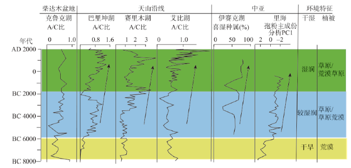 显示原图|下载原图ZIP|生成PPT
图2孢粉记录的亚洲中部干旱区丝绸之路沿线气候环境变化[
-->Fig. 2Environmental and climatic changes along the Silk Road in arid Central Asia documented by pollen records
-->
吉尔吉斯斯坦的伊赛克湖的孢粉记录也表现出从中全新世到晚全新世代表湿润气候的种属增加的趋势[23]。新近发表的里海的孢粉记录也表明[24],早全新世的植被以荒漠类型的灌丛为主,中全新世的植被以草原和荒漠植被为特征,栎属和榛属的乔木得到扩展,晚全新世的植被以草原为主,乔木的种类更加多样化。
上述记录显示,河西走廊受季风影响,表现出季风—西风过渡带干湿变化的模式,其余地区的气候环境变化比较一致:在早全新世(BC 6000以前)主要为干旱环境,植被以荒漠类型占优势;BC 6000-2000期间,气候环境较为适宜,草原植被增加,山地林带和草原带都得到扩张;BC 2000以后,湿润程度进一步增加,草原植被扩展。
4.2 过去2000年来研究区的气候环境变化
在晚全新世新疆和中亚等地气候总体湿润的背景下,过去2000年仍然表现出次一级的变化[25-32]。新疆和中亚等地在中世纪暖期比较干旱,在小冰期比较湿润[27],在AD 1400-1850期间,天山和帕米尔出现明显的冰进[31-32]。而受季风影响的柴达木盆地东部地区,AD 100-500和AD 1400-1850比较干旱,其他时段比较湿润[25]。但这一时期人类活动的强度已经大大增加,成为影响环境变化的重要因素,例如楼兰古城的废弃就被认为和人类活动有关[5]。而战争期间为了战胜对方,强行迫使河流改道,最终导致绿洲退化、城池毁弃的例子不胜枚举。尤其作为沟通东西方的交通路线来说,受环境变化的影响更大。这主要包括以下几方面的影响:湖泊和水系的变迁导致可供利用的水源的变化,最终导致交通路线的变化,最典型的就是楼兰废弃对丝绸之路路线的影响;其次是风沙活动的强弱,或者沙漠的扩张与收缩;再次是高山冰川的前进或者后退,因为丝绸之路上的很多山口或者垭口不仅海拔高,而且冰川活动往往会塑造出非常剧烈的地形变化,增加了通行的难度。例如《汉书·西域传上》的记载:“又历大头痛、小头痛之山,赤土、身热之阪,令人身热无色,头痛呕吐,驴畜尽然,”写尽了高山反应的痛苦。其中“又有三池、盘石阪,道狭者尺六七寸,长者径三十里。行者骑步相持,绳索相引…人堕,势不得相收视。险阻危害,不可胜言。”又极言道路之艰危。在AD 100-500和AD 1400-1850,这两个时期,风沙活动强烈[30],冰川前进[31-32]。前者大致对应于丝绸之路的初期,后者大致对应于丝绸之路的衰落期。
在过去2000年里,人类活动和自然变化交织在一起,共同塑造了这个时期的环境变迁。人类活动和自然变化的合力,导致的最严重的后果就是河流断流、农田堙没、湖泊干涸,以及不合理的灌溉造成的土地的盐碱化和荒漠化。例如里海东岸的灌溉农业对天然河道和绿洲的影响[33],类似的例子在天山沿线和河西走廊也可以发现[34]。
4.3 史前丝绸之路上的东西方农作物交流与农业经济特征的变化
丝绸之路开始于公元前2世纪。但沿丝绸之路东西方文化的交流,远在更早的时期就已经存在了[8-10, 33]。以小麦和大麦为代表的西方作物和以粟黍为代表的中国北方作物的相向交流就很具有代表性[35-89](图3,图4),这些作物的传播交流和相互结合成为史前时期的一道风景。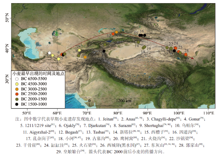 显示原图|下载原图ZIP|生成PPT
图3研究区发现早期小麦遗存的主要遗址
-->Fig. 3The earliest wheat findings in different sites along the Silk Road in the study area
-->
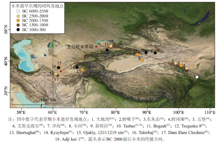 显示原图|下载原图ZIP|生成PPT
图4研究区发现早期小米遗存的主要遗址
-->Fig. 4The earliest millet findings in different sites along the Silk Road in the study area
-->
西方农业文化源起新月沃地,培育了小麦等农作物[7]。中国北方则在新石器时代形成了以粟黍为主要作物的农业[7-10, 90]。在距今1万年左右,小麦和小米在新月沃地和中国北方分别被驯化[7, 90]。里海东岸位于新月沃地的边缘,农业很早就开始发展,至迟在BC 5500,里海东岸就出现了以小麦和大麦为主要作物的农业和饲养山羊绵羊等家畜的畜牧业[58]。同一时期,在中国北方的粟黍农业得到了一定的发展[9, 90]。但粟黍农业在这一时期还没有进入河西走廊。
从里海到中哈边界的广大区域,农业发展长时间局限在科佩特山的山麓绿洲。至BC 3800前后,小麦才从科佩特山北麓的绿洲地带扩展到塔吉克斯坦境内的天山西端[80]。同一时期,粟黍农业在黄土高原西部得到广泛发展[9-10, 91]。在BC 2500-2000期间,小麦传播到了哈萨克斯坦境内伊犁河流域的Begash和Tasbas遗址[55, 57],稍晚于BC 2000出现在天山以南的新塔拉和小河遗址[54, 56-67],以及河西走廊的火石梁遗址[54]。同时,粟黍在BC 2500-2000期间首先进入河西走廊[66],并于稍晚的时期在伊犁河流域的Begash和科佩特山北麓的Adji kui 1遗址都有发现[57, 83]。
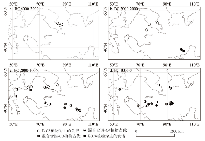
在BC 2000-1000期间,小麦/大麦和粟黍相结合的新型农业迅速地遍及了从河西走廊到里海沿岸的丝绸之路沿线,并扩散到欧亚草原带。显然,这个时期的文化交流的规模和速度比以前大大增加了。这个过程在同位素记录的食谱变化中间得到了很好的佐 证[36-39, 41-48, 50, 61, 66, 70-72, 75, 83-85](图5)。在BC 3000以前,研究区的食谱记录都以C3植物为主。在BC 3000-2000,河西走廊显示出以C4为主的食谱特征,表明粟黍分布范围的向西扩展,粟黍成为河西走廊居民的主要作物。BC 2000以后,研究区大多数的研究地点出现了C3-C4混合型的食谱特征,表明粟黍已经成为研究区很多地点居民的食用作物,小麦/大麦也成为河西走廊居民主要的作物之一。
 显示原图|下载原图ZIP|生成PPT
图5研究区不同时期同位素记录的食谱变化
-->Fig. 5The dietary changes documented by isotopic records
-->
随着东西方作物相向传播,形成了以小麦/大麦—粟黍—畜牧为特征的混合型经济特征,表现在同位素上就是C3-C4混合型的食谱特征。这种极具地域特色的混合型生业模式出现略早于BC 2000,至BC 1000已经成为从里海到河西走廊的绿洲农业的普遍特征。
东西方的农业的交汇,使得这里的农业具有两者共同的特征,这个特征一致延续到历史时期。如《大唐西域记》中记载的位于新疆和中亚的西域诸国的农作物多黍麦并举,小米和小麦成为最重要的两种作物(表1),《史记》及以后的史书中偶尔会提到水稻、荞麦等作物,但它们的分布很有限,远远不能和黍麦相比。在果蔬方面,该书的记载也表现出东西方交汇的特征,比如阿耆尼国的水果有“香枣蒲萄梨柰”,完美地表现了不同起源地的水果的交汇:枣和梨是源起中国北方的果品,蒲萄(即葡萄)源起黑海和里海之间的区域,逐步传入中亚,经新疆传入内地,柰(绵苹果)是新疆和中亚的产物[92]。
Tab. 1
表1
表1《大唐西域记》所记载的位于新疆和中亚的西域诸国的农业特征
Tab. 1The features of agriculture in nations located in western regions documented by Datangxiyuji
| 地点 | 农作物 | 果蔬 | 其他 |
|---|---|---|---|
| 阿耆尼国 | 土宜穈黍宿麦 | 香枣蒲萄梨柰 | 伽蓝十余所,僧徒二千余人 |
| 屈支国 | 宜穈麦有粳稻 | 蒲萄石榴,多梨柰桃杏 | 伽蓝百余所,僧徒五千余人 |
| 素叶水城 | 土宜糜麦 | 蒲萄 | |
| 笯赤建国 | 地沃壤备稼穑 | ||
| 赭时国 | 土宜气序同笯赤建国 | 《隋书·西域传》称其“有粟麦” | |
| 怖捍国 | 土地膏腴稼穑滋盛 | 多花果 | |
| 飒秣建国 | 土地沃壤稼穑备植 | 花果滋茂 |
新窗口打开
至清代前期,这些区域的农作物组成还是没有发生大的变化,譬如清代椿园所著《西域见闻录》中对西域作物的记载:“土产二麦,谷,糜,瓜,蒲桃”。直至清代道光时期,玉米被大面积引种,粮食作物的组成才发生了变化(《哈密志》)。
所以,粟黍农业和麦作农业的初次融合发生在BC 2500-2000,小米在此期间传播到了中亚和科佩特山的东端,小麦传播到了河西走廊。两者融合形成的小麦或/和大麦—粟黍—畜牧为特征的混合型经济特征成为丝绸之路沿线绿洲农业的“标配”,这种特征一直持续到近代。
5 环境变化与丝绸之路人类活动的关系
5.1 地理环境和生业模式的空间分异
丝绸之路沿线独特的地理环境特征分异,造就了研究区独特的生业经济模式。在山地草原和荒漠盆地,畜牧是最重要的经济特征。至迟在青铜时代,牧民就形成了转场的习俗,即春季利用山地海拔较低的山麓地带的草原,夏季转场到山地草原和亚高山草原,秋冬季节再回到山麓盆地的荒漠草原地带[51, 93]。而在山麓绿洲,农业—畜牧业的混合经济是其主要特征,发展了定居的聚落。所以,根植于山麓的农业绿洲,是畜牧的汪洋大海中的岛链,连接起了贯穿东西的丝绸之路。绿洲在自然环境上天然优越于附近的山区,环境承载力大于山地草原和荒漠草原,即单位土地面积可以养活的人口远远大于山地草原和荒漠草原。比如在1902年,新疆总人口为206万余,其中农业人口达156万[94]。绿洲密集的人口分布和多样的食物来源促进了更为庞大的聚落发展,甚至有可能产生一个大的聚落群,比如在公元前1千纪势力遍及整个哈密盆地的焉不拉克文化体系,在这个庞大的聚落群内,各聚落之间交流密切,习惯、物品甚至人员在一定程度上实现了共享[9-10, 95]。
同时,因为山地草原和荒漠草原地带的牧业经济形式较为单一,抵御自然灾害的能力差,比如一场暴雪可能会导致牲畜的大量死亡,使牧民丧失大部分的生活来源。而绿洲地区不同,绿洲农业依赖于山地的冰雪融水,水源供应稳定,受其他气候灾害的冲击较小,同时绿洲多样的生产方式提升了其在面临灾难时的承受能力,即使有所损失,但依然能有大部分保留。另外,土地承载力的不同决定了山区牧民为了维持一定数量的畜产,必须保证相当大面积的草场,导致牧民与牧民之间必须相隔一定的距离才能保障各自的稳定生活来源,这样就在一定程度上限制了彼此交流的频率和深度。
另外不能忽视的事实是,两种环境下截然不同的人口出生率,在传统的牧民家庭,因为要经常性的移动转场,一个母亲的精力不能照顾太多幼儿,所以出生间隔一般在4~5年,而绿洲地区的定居者则不需要面临这样的问题,出生率远高于山区居民,进一步保证了人口的密集度。然而,绿洲毕竟面积狭小,且不连续,很难支撑跨区域的独立政权。所以,丝绸之路沿线的古代国家,往往是以绿洲为根基的城邦型国家,国土沿山麓地带狭长分布,且面积不大。汉代有西域三十六国,唐代西域亦有数十国。例如唐代的屈支国“东西千余里,南北六百余里,国大都城周十七八里…泉流交带引水为田”(《大唐西域记》卷1)。即使在突厥等汗国统治的时期,也往往会出现“城皆立长”,“不相禀命”的情形(《大唐西域记》卷1)。自然环境的特征极大地影响了农牧业的发展和空间分异,进而影响到上层建筑的架构。
5.2 环境变化与文化交流
如前文所述,研究区无论是全新世还是过去2000年,环境记录所表现出的湿度时空分异都表现出从西风区逐步到季风边缘区的特征,即中亚和中国新疆的降水/湿度表现出与中纬度东亚季风区成相反的变化趋势,而河西走廊东部等地由于地处季风边缘区,同时受到季风信号的影响[96]。这种气候环境变化的时空分异,同样对东西文化交流产生了影响。史前时期,丝绸之路上向东方输送的是小麦和大麦为代表的农作物,绵羊和马等家畜,以及金属冶炼等技术,从中国北方向西输送的是粟黍为代表的农作物,猪和鸡等饲养动物,以及彩陶等技术。
历史时期的丝绸之路形成于公元前2世纪,兴盛于公元6-14世纪,通过丝绸之路的人员往来,促进不同民族和不同文化背景的人们相互融合,致使有些城市发展为重要的文化和艺术中心,促进了技术、艺术风格、语言、社会习俗与宗教信仰的交流与传播(http://whc.unesco.org/en/list/1442)。汉文、佉卢文、婆罗米文、粟特文、回鹘文等先后在丝绸之路上被使用,记录了丝绸之路的兴盛。宗教的变化更加频繁。譬如,在伊斯兰教传入之前,中亚地区的居民信奉过佛教、祆教、摩尼教、景教等等宗教,中亚和新疆的壁画中能见到多种文化交融的现象。公元8世纪时,伊斯兰教开始进入中亚[97]。10世纪初,伊斯兰教传入新疆喀什地区,16世纪时取代佛教成为天山以南的主要宗教[98]。随着丝绸之路的兴盛,活跃的贸易带来了西方的玻璃、宗教、科技、艺术,带走了中国的丝绸、漆器、茶叶和技术。
16世纪以后,丝绸之路上的商业往来逐步衰落。明代弘治以后放弃哈密、封闭嘉峪关可以看做是丝绸之路衰落的标志。这一方面是随着航海技术的发展,海洋日渐成为东西方贸易的主要通道。即使清朝统一新疆后和中亚的贸易略有恢复,已是日近西山,贸易的构成成分以及性质也发生了极大的变化。另一方面,近代民族国家的出现,阻碍了丝路沿线人员和贸易的自由往来;还有一个原因,就是随着俄罗斯逐步占据从东欧直达远东的欧亚草原带,茶叶、丝绸等从中国至东欧的陆上贸易更多地取道草原路,即从中国北方经蒙古,进入俄罗斯境内,转口输往欧洲。特别是728年中俄签订了《恰克图条约》,自此恰克图就成为中俄贸易的主要市场,中国输出的货物以茶叶为大宗,输入的主要是毛皮等货物[99],贸易的成分显然和丝绸之路兴盛时期不同。
此前许多****都曾经把欧亚草原带作为东西方农业交流的主要通道,但新的资料表明,这个地带的许多农业资料的年代是值得商榷的。比如原先认为年代可以达到BC 5000的东欧地区的黍的年代,经重新测定,基本都晚于BC 1600[100]。所以,本文认为,欧亚草原带东部的农业发展要晚于里海东岸,也晚于黄土高原西部。粟黍从中国西北地区向欧亚草原带的扩散本文推测有两个主要通道:一是从河西走廊通过阿尔泰山向北传播,抵达米努辛斯克盆地,二是沿天山向欧亚草原带的扩散。从哈萨克斯坦北部的南西伯利亚到米努辛斯克盆地的广大区域,农业发展的历史很可能不会早于BC 2000。但这个问题比较复杂,本文不再展开讨论。
丝绸之路沿线独特的地理环境及其时空分异,深刻地影响着文化的发展和传播。在史前时期,东西方农业的相向传播和融合,基本沿着山前地带的绿洲蛙跳式前进,譬如从科佩特山北麓向天山西段的跃进。史前小麦从里海东岸向河西的传播主要有3个阶段:BC 3800以前,小麦集中在科佩特山麓的绿洲地带;BC 3800-2500,它逐步扩展到中亚的天山绿洲地带;在BC 2500-1800,扩展到新疆和河西的许多绿洲。小米从黄土高原向西传播主要有两个阶段:BC 2500左右从黄土高原进入到河西走廊的东端,在BC 2500-1800,扩展到新疆和中亚的许多绿洲。
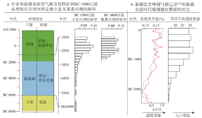 显示原图|下载原图ZIP|生成PPT
图6气候环境变化与人类活动的对比
-->Fig. 6The comparison between Holocene environmental changes and human activities
-->
新疆和中亚全新世中期较为湿润的气候环境为这一过程提供了较适宜的环境基础(图6a)。晚全新世湿润的气候条件加速了这一过程。可以想见,随着气候湿润程度的增加,不仅绿洲扩大,河流水量增加,而且山地草原带的面积得到扩展,为农业和畜牧业的蓬勃发展提供了更多的生态支撑。所以小麦和粟黍在丝绸之路沿线出现的频率在BC 2000以后出现了高峰,小麦/大麦—粟黍混合型农业迅速形成,明显区别于BC 2000以前河西走廊的粟黍农业和科佩特山麓的小麦/大麦农业。在BC 2000-1000期间,丝绸之路沿线形成了小麦/大麦—粟黍—畜牧为特征的混合绿洲经济和包围在绿洲周边的畜牧业的这样一种空间结构。值得注意的是,BC 2000以后,新疆和中亚的混合经济的遗址点是增加的,而河西走廊的混合经济的遗址数量短暂上升,然后迅速下降。这显然和气候环境的空间分异有关,新疆和中亚在晚全新世趋向湿润,而河西走廊在晚全新世趋向干旱。
得益于气候环境条件的改善,东西方文化交流融合的进程在BC 2000以后加速,在中亚和新疆表现得很明显。以新疆为例(图6b),这里是东西方文化的交汇之地,遗址数量的增加表明人口的增长和文化分布范围的扩大。BC 2000-1000期间,气候湿润程度增加,遗址数量持续增长,暗示人口规模扩大,分布到了更多的区域,显然东西方文化的交流的规模远超BC 2000以前的时期。BC 1000以后,遗址数量相对稳定,东西方文化交流保持在稳定的水平。
到了历史时期,具有更强控制力的国家政权在丝绸之路沿线出现,出于政治和经济考虑,许多国家意图控制丝绸之路,政治版图的变化成为影响丝绸之路的首要因素。例如安息帝国为了防止罗马人和汉朝建立直接商贸关系,不惜和罗马帝国兵戎相见,同时又在丝绸之路沿线修建了许多商站,为往来商旅提供饮水等服务。当然,安息帝国从中获得了稳定可观的商税收入。位于丝绸之路东端的汉朝在击败匈奴以后才有能力沟通东西,汉朝和匈奴的征战始终影响着丝绸之路的畅通与否。汉军最终打败匈奴,取得了河西走廊和西域,确保了西域通道的安全。沟通东西方的“丝绸之路”,至此畅通。
魏晋南北朝时期,丝绸之路不断发展。北魏太安元年(AD 455),据有两河流域和中亚大部的波斯萨珊王朝与统一了中国北方的北魏王朝建立了直接的联系(《魏书》)。AD 589年隋王朝重新统一中国时,突厥占领了蒙古高原至里海间广大地区,丝绸之路的交通受到不少阻碍。唐朝初期,西域虽大都在西突厥控制之下,但西域各国逐步归附唐王朝,因此很快恢复了丝路交通。此后经过陆续的征战,唐王朝重新确立了对西域的有效管理,和据有西亚的大食帝国接壤。唐代丝绸之路的畅通繁荣,一方面是国家政治清明,另一方面是正处于中国历史上的隋唐暖期[101],国力强盛,而在天山和中亚等地,冰川退缩,风沙活动减弱,改善了沿途的通行条件。《资治通鉴》216卷中说唐天宝十二年(AD 753)“自安远门西尽唐境凡万二千里,闾阎相望,桑麻翳野”,也就是说从长安的安远门出发,经河西走廊直至西域的唐王朝边界,农业兴旺,人烟稠密。这个记述即使有所夸大,也在一定程度上反映了沿途自然人文环境的改善。
而丝绸之路的衰落固然和航海技术的发展、中亚兴起的政治势力的阻隔有关,但环境条件的变化也是加速其衰落的重要外因。在新疆和中亚等地,冰川前进,风沙活动增强,增加了通行的困难。同时,受季风影响的河西走廊在此时的沙漠化的程度大大加 剧[102],不复“天下称富庶者莫如陇右”的盛景,这是季风衰退和人类活动共同造成的后果。历史时期丝路的兴衰,研究文献很多,限于篇幅,这里不再赘述。
6 结论
(1)自河西走廊到里海是丝绸之路上自然条件最艰险的部分,河西走廊受季风影响,表现出季风—西风过渡带干湿变化的模式,气候在晚全新世趋向干旱;其余地区的气候环境变化比较一致:在早全新世(BC 6000以前)主要为干旱环境,植被以荒漠类型占优势;BC 6000-2000期间,气候环境较为适宜,草原植被增加,山地林带和草原带都得到扩张;BC 2000以后,湿润程度进一步增加,草原植被扩展。(2)以小麦和大麦为代表的西方作物和以粟黍为代表的中国北方作物的相向交流早在丝绸之路以前就存在。在BC 2500-2000期间,两种农业在丝绸之路沿线开始融合,史前丝绸之路贯通;在BC 2000-1000期间,小麦/大麦和粟黍相结合的新型农业迅速地遍及了从河西走廊到里海沿岸的丝绸之路沿线,并向欧亚草原带扩散,形成了绿洲地带以小麦/大麦—粟黍—畜牧为特征的混合型经济特征。山麓地带的农业绿洲,是畜牧的汪洋大海中的岛链,连接起了贯穿东西的丝绸之路。这种空间分异,是地理环境和东西方文化交流共同作用的结果。
(3)丝绸之路沿线独特的地理环境,深刻地影响着文化的发展和传播。在史前时期,东西方农业的相向传播和融合,基本沿着山前地带的绿洲蛙跳式前进。史前小麦从里海东岸向河西的传播主要有3个阶段:BC 3800以前,小麦集中在科佩特山麓的绿洲地带;BC 3800-2500,它逐步扩展到中亚的天山绿洲地带;在BC 2500-1800,扩展到新疆和河西的许多绿洲。小米从黄土高原向西传播主要有两个阶段:BC 2500左右从黄土高原西部进入到河西走廊的东端,在BC 2500-1800,扩展到新疆和中亚的许多绿洲。
(4)新疆和中亚全新世中期较为湿润的气候环境为这一过程提供了较适宜的环境基础。得益于气候环境条件的改善,东西方文化交流融合的进程在BC 2000以后明显加速。在历史时期,政治版图的变化是影响丝绸之路的首要因素,但环境的变化仍然影响着丝绸之路的具体路线。丝绸之路的衰落和航海技术的发展、政治势力的阻隔有关,但环境条件的变化是不可忽视的重要外因。
致谢:感谢新疆考古与文物研究所于志勇、李文瑛、于建军、王永强、胡望林等同仁,以及中国社会科学研究院考古所丛德新、郭物等先生对在新疆研究工作的大力支持。
The authors have declared that no competing interests exist.
参考文献 原文顺序
文献年度倒序
文中引用次数倒序
被引期刊影响因子
| [1] | |
| [2] | . |
| [3] | 近百年来,在楼兰考古和古丝绸之路的考察研究过程中,楼兰-鄯善国都城何在?一直是国内外考古、历史、地理等诸多学科关注的热点.通过对罗布泊小河墓地西北约6.3km处新发现的古城遗址以及楼兰(LA)、方城(LE)、且尔乞都克古城、米兰古戍堡、土垠等遗址18个建筑物等样品的^14C年龄分析,结果表明:小河墓地西北新发现的古城城墙年代大约在公元440-500年左右,形成于北魏时期(公元386~534年),相对楼兰(LA)佛塔(约公元100-230年)、方城(LE)城墙(约公元230~300年)、且尔乞都克城墙(约公元200年)、土垠(约公元100年)建筑时间年轻约100~300年.米兰遗址古戍堡内房柱年龄约公元370年,古戍堡西门北侧墙基年龄最为年轻(约公元770年1,属于唐朝时期.小河墓地西北新发现的古城遗址,根据墙体年代和初步发现的文物类型以及地理位置,有可能是文献中记载的“注宾城”,可暂定名为“注宾河古城遗址”,该古城遗址的隶属、职能,还有待详细的考古发掘工作.由于该遗址临近丝绸之路古驿站阿拉干,处于丝绸之路东西和南北交通要道的十字路口上,因此无论该遗址是否是“注宾城”、或“埒娄城”、或楼兰国都“扦泥城”,它在丝绸之路上的重要位置都是毋庸置疑的.通过对不同古城遗址的年代学分析,为深入研究罗布泊地区古代遗址的时间.空间分布、西域文化的演化过程、人类活动与环境变化关系等提供了新证据. . 近百年来,在楼兰考古和古丝绸之路的考察研究过程中,楼兰-鄯善国都城何在?一直是国内外考古、历史、地理等诸多学科关注的热点.通过对罗布泊小河墓地西北约6.3km处新发现的古城遗址以及楼兰(LA)、方城(LE)、且尔乞都克古城、米兰古戍堡、土垠等遗址18个建筑物等样品的^14C年龄分析,结果表明:小河墓地西北新发现的古城城墙年代大约在公元440-500年左右,形成于北魏时期(公元386~534年),相对楼兰(LA)佛塔(约公元100-230年)、方城(LE)城墙(约公元230~300年)、且尔乞都克城墙(约公元200年)、土垠(约公元100年)建筑时间年轻约100~300年.米兰遗址古戍堡内房柱年龄约公元370年,古戍堡西门北侧墙基年龄最为年轻(约公元770年1,属于唐朝时期.小河墓地西北新发现的古城遗址,根据墙体年代和初步发现的文物类型以及地理位置,有可能是文献中记载的“注宾城”,可暂定名为“注宾河古城遗址”,该古城遗址的隶属、职能,还有待详细的考古发掘工作.由于该遗址临近丝绸之路古驿站阿拉干,处于丝绸之路东西和南北交通要道的十字路口上,因此无论该遗址是否是“注宾城”、或“埒娄城”、或楼兰国都“扦泥城”,它在丝绸之路上的重要位置都是毋庸置疑的.通过对不同古城遗址的年代学分析,为深入研究罗布泊地区古代遗址的时间.空间分布、西域文化的演化过程、人类活动与环境变化关系等提供了新证据. |
| [4] | We synthesize palaeoclimate records from the mid-latitude arid Asian region dominated today by the Westerlies (“arid central Asia” (ACA)) to evaluate spatial and temporal patterns of moisture changes during the Holocene. Sediment records from 11 lakes with reliable chronologies and robust proxies were selected to reconstruct moisture histories based on a five-class ordinal wetness index with assigned scores from the driest to wettest periods at individual sites for 200-year time slices. The proxies used in these records include pollen and diatom assemblages, sediment lithology, lake levels, and geochemistry (mainly isotope) data. The results of our synthesis show that ACA as a whole experienced synchronous and coherent moisture changes during the Holocene, namely a dry early Holocene, a wetter (less dry) early to mid-Holocene, and a moderately wet late Holocene. During the early Holocene most of the lakes experienced very low water levels and even dried out before ca 802ka (102ka=100002cal02a02BP). Hence the effective-moisture history in ACA is out-of-phase with that in monsoonal Asia as documented by numerous palaeoclimate records. In monsoonal Asia, a strong summer monsoon and humid climate characterized the early Holocene, and a weakened summer monsoon and drier climate prevailed during the late Holocene, which were mainly controlled by changes in low-latitude summer insolation. In contrast, we propose that the pattern of Holocene effective-moisture evolution in the westerly dominated ACA was mainly determined by North Atlantic sea-surface temperatures (SSTs) and high-latitude air temperatures that affect the availability, amount and transport of water vapor. Also, topography of the Tibetan Plateau and adjacent Asian highlands could have contributed to the intensification of dry climate in ACA during the early Holocene, as a result of strengthening the subsidence of dry air masses, associated with stronger uplift motion on the plateau by intense heating under a stronger summer insolation. Summer insolation might have played a key role in directly controlling moisture conditions in ACA but only after the northern hemisphere ice-sheets had disappeared in the mid- and late Holocene. |
| [5] | 利用历史文献和考古成果,结合 野外调研,研究历史时期以来塔里木河下游的行政变化和交通变迁,在此基础上分析了下游生态环境的演变特征。研究认为,从细石器到汉晋时期,塔里木河下游气 候湿润,生态环境比较稳定,人类活动从原始经济向城邦文明稳步演进,对外交通便利,形成塔里木盆地东部重要的鄯善(楼兰)独立王国;东晋以后,气候逐渐变 干,下游对外联系的主要交通枢纽和交通线路废弃,鄯善国消亡,塔里木河下游绿洲成为封闭的游牧区;18世纪中期以后气候湿润,下游绿洲归属于吐鲁番政区管 辖,对外联系比较方便;19世纪末期,气候变化剧烈,趋向干旱,塔里木河下游与吐鲁番之间的政区、交通联系中断,开始属于塔里木河流域的上一级行政区管 辖。 . 利用历史文献和考古成果,结合 野外调研,研究历史时期以来塔里木河下游的行政变化和交通变迁,在此基础上分析了下游生态环境的演变特征。研究认为,从细石器到汉晋时期,塔里木河下游气 候湿润,生态环境比较稳定,人类活动从原始经济向城邦文明稳步演进,对外交通便利,形成塔里木盆地东部重要的鄯善(楼兰)独立王国;东晋以后,气候逐渐变 干,下游对外联系的主要交通枢纽和交通线路废弃,鄯善国消亡,塔里木河下游绿洲成为封闭的游牧区;18世纪中期以后气候湿润,下游绿洲归属于吐鲁番政区管 辖,对外联系比较方便;19世纪末期,气候变化剧烈,趋向干旱,塔里木河下游与吐鲁番之间的政区、交通联系中断,开始属于塔里木河流域的上一级行政区管 辖。 |
| [6] | The isotopic and material composition of bottom deposits, examined in the Kara-Bogaz-Gol Gulf, Lake Issyk-Kul, and the Aral Sea , is considered. The obtained data are used to characterize variations in the regime of the water bodies in the Holocene. |
| [7] | During the initial phase of cereal cultivation in East Asia, domesticated traits emerged only slowly. |
| [8] | 古道西风 : 考古新发现所见中西文化交流 林梅村著 (三联99哈佛燕京学术丛书) 生活99讀書99新知 三聯書店, 2000.3 北京第1版 . 古道西风 : 考古新发现所见中西文化交流 林梅村著 (三联99哈佛燕京学术丛书) 生活99讀書99新知 三聯書店, 2000.3 北京第1版 |
| [9] | |
| [10] | 东风西渐 : 中国西北史前文化之进程 李水城著 文物出版社, 2009.10 . 东风西渐 : 中国西北史前文化之进程 李水城著 文物出版社, 2009.10 |
| [11] | |
| [12] | Stable carbon isotopic analyses of human skeletal remains may provide fundamental evidence for human dietary reconstruction and subsistence strategies. Millet is closely associated with the emergence and development of agriculture-based societies in northern China. Although often overlooked, baseline values of millet seeds are essential for using stable isotope analysis to understand past human and animal diets. Here, we report spatial and temporal variations in the δ 13 C values of millets by analyzing modern samples, including seeds and leaves, as well as archaeological samples. The δ 13 C values of modern foxtail millet seeds range from6113.9 to6111.3‰, with a mean value of6112.3±0.5‰ (1 σ , n =66), while δ 13 C values for modern common millet seeds vary between6114.3 and6112.0‰, with a mean value of6112.8±0.6‰ (1 σ , n =19). There is an approximately 1‰ temporal change in δ 13 C for millet grains. Leaves have lower δ 13 C values than grains, implying that eaters living on different tissues of the same plant could show different isotopic values. These background δ 13 C values must be considered when reconstructing the dietary history of a millet-based society. |
| [13] | 中国干旱区内陆河流域中游地区分布了大量晚第四纪河、湖相交替的沉积地层,这些沉积物被广泛用于古气候和古环境重建.然而,以往的研究较多关注沉积物的理、化、生指标,而忽略了沉积相变的古环境意义,这可能使古环境重建结果产生偏差.针对这一问题,选取干旱区典型内陆河——石羊河中游地区的JDT全新世沉积剖面,进行年代学、沉积相、岩性和粒度的研究,并与该区域已有的HSH全新世剖面的地球化学和古生物指标进行对比,在分析沉积相的基础上讨论二者的环境代用指标,重建石羊河中游地区全新世的古环境.两个剖面在年代和岩性上具有很好的一致性,指示了石羊河中游地区约8500 cal yr BP-3000 cal yr BP以来的沉积过程.两剖面从底部到上部可分为六层:河流相沉积(F层)——河湖相沉积(E层)——湖相沉积(D层)——浅湖-风成沉积(C层)——风成沉积(B层)——风成沉积(A层),代表了不同沉积相及其转换过程.综合讨论沉积物岩性、沉积相和各种古环境代用指标认为:石羊河中游地区的沉积相体现了从河流相到湖相再到风成沉积物的变化过程,指示了全新世的干旱化过程.这与以往研究中认为石羊河流域全新世气候变化具有波动性的观点存在一定差异.因此,在研究沉积相变化的基础之上讨论沉积物的物理、化学和生物指标的含义,而非简单地研究这些指标的数值,是干旱区流域性气候变化对比研究的新视角. . 中国干旱区内陆河流域中游地区分布了大量晚第四纪河、湖相交替的沉积地层,这些沉积物被广泛用于古气候和古环境重建.然而,以往的研究较多关注沉积物的理、化、生指标,而忽略了沉积相变的古环境意义,这可能使古环境重建结果产生偏差.针对这一问题,选取干旱区典型内陆河——石羊河中游地区的JDT全新世沉积剖面,进行年代学、沉积相、岩性和粒度的研究,并与该区域已有的HSH全新世剖面的地球化学和古生物指标进行对比,在分析沉积相的基础上讨论二者的环境代用指标,重建石羊河中游地区全新世的古环境.两个剖面在年代和岩性上具有很好的一致性,指示了石羊河中游地区约8500 cal yr BP-3000 cal yr BP以来的沉积过程.两剖面从底部到上部可分为六层:河流相沉积(F层)——河湖相沉积(E层)——湖相沉积(D层)——浅湖-风成沉积(C层)——风成沉积(B层)——风成沉积(A层),代表了不同沉积相及其转换过程.综合讨论沉积物岩性、沉积相和各种古环境代用指标认为:石羊河中游地区的沉积相体现了从河流相到湖相再到风成沉积物的变化过程,指示了全新世的干旱化过程.这与以往研究中认为石羊河流域全新世气候变化具有波动性的观点存在一定差异.因此,在研究沉积相变化的基础之上讨论沉积物的物理、化学和生物指标的含义,而非简单地研究这些指标的数值,是干旱区流域性气候变化对比研究的新视角. |
| [14] | 通过分析河西走廊花海古湖泊沉积物中的盐类矿物组成,结合年代序列,重建了花海晚冰期以来湖 泊演化过程及其对气候变化的响应。结果表明:晚冰期及新仙女木时期,花海湖泊以芒硝沉积为主,属硫酸盐型湖泊,湖水的盐度较高且周期性波动频繁;全新世早 期(10.47 cal ka BP以前),湖泊以洪泛堆积和风成沉积为主,揭示了湖泊萎缩、甚至干涸;全新世早期至全新世中期(10.47~8.87 cal ka BP)盐类矿物以碳酸盐沉积为主,为碳酸盐型湖泊,湖水淡化,湖泊水位开始逐渐回升;全新世中期(8.87~5.50 cal ka BP)盐类矿物呈现一定的波动变化,其中,8.8 cal ka BP 时期盐类矿物以硫酸盐沉积为主,湖泊由碳酸盐型转化为硫酸盐型,湖水咸化,盐度升高;随后盐类矿物以碳酸盐沉积为主,湖泊由硫酸盐型转化为碳酸盐型,湖水 盐度降低、湖泊扩张;全新世中晚期(5.50 cal ka BP以来)出现沉积间断,表明中晚全新世时期湖泊逐渐萎缩。在全新世期间,花海湖泊千年尺度演化过程揭示了该区域气候干湿状况受亚洲季风和西风共同控制的 影响。 . 通过分析河西走廊花海古湖泊沉积物中的盐类矿物组成,结合年代序列,重建了花海晚冰期以来湖 泊演化过程及其对气候变化的响应。结果表明:晚冰期及新仙女木时期,花海湖泊以芒硝沉积为主,属硫酸盐型湖泊,湖水的盐度较高且周期性波动频繁;全新世早 期(10.47 cal ka BP以前),湖泊以洪泛堆积和风成沉积为主,揭示了湖泊萎缩、甚至干涸;全新世早期至全新世中期(10.47~8.87 cal ka BP)盐类矿物以碳酸盐沉积为主,为碳酸盐型湖泊,湖水淡化,湖泊水位开始逐渐回升;全新世中期(8.87~5.50 cal ka BP)盐类矿物呈现一定的波动变化,其中,8.8 cal ka BP 时期盐类矿物以硫酸盐沉积为主,湖泊由碳酸盐型转化为硫酸盐型,湖水咸化,盐度升高;随后盐类矿物以碳酸盐沉积为主,湖泊由硫酸盐型转化为碳酸盐型,湖水 盐度降低、湖泊扩张;全新世中晚期(5.50 cal ka BP以来)出现沉积间断,表明中晚全新世时期湖泊逐渐萎缩。在全新世期间,花海湖泊千年尺度演化过程揭示了该区域气候干湿状况受亚洲季风和西风共同控制的 影响。 |
| [15] | We present fossil pollen data and discuss their climatic interpretations from a 688-cm-long sediment core from Hurleg Lake, a freshwater lake located in the Qaidam Basin on the NE Tibetan Plateau, just beyond the northern limit of the East Asian summer monsoon influence. The reconstruction of the Holocene vegetation and climate history was aided by modern surface pollen analysis. The 14000-yr chronology of the sediment core was controlled by seven AMS 14 C dates on plant macrofossils. The results of the surface pollen analysis showed that modern pollen spectra faithfully reflect the regional vegetation along a transect from alpine meadow to desert steppe and desert, so fossil pollen record can be used to reconstruct Holocene vegetation change. The pollen data showed that vegetation changed from desert before the Holocene to desert steppe dominated by Artemisia from 11.9 to 9.5ka, desert dominated by Chenopodiaceae from 9.5 to 5.5ka, and steppe desert dominated by Artemisia and Poaceae after 5.5ka. This vegetation sequence indicates that climate was relatively wet before 9.5ka, dry and variable from 9.5 to 5.5ka, and relatively wet and stable after 5.5ka. The climate pattern reconstructed from pollen data appears to be opposite to the paleoclimate pattern inferred at Qinghai Lake, 300km east of our study site. That site shows a moist early Holocene during the insolation and monsoon maximum followed by a drying trend during the mid- and late Holocene. The contrast between the two sites suggests the importance of the position of the subtropical monsoon, the mid-latitude westerlies and interactions between local topography and regional climate. Our finding has important implications for understanding complex regional vegetation and climate responses to large-scale forcings in arid central Asia. |
| [16] | Our country land all sorts of different utilization and related planning for different environmental factors and these factors together constitute the ecological system are far-reaching,environment evaluation for our designers better land planning guidance,to prevent various adverse situations is also very important.This paper mainly studies our country land use planning various evaluation system based on the theory,and the combination of these different theoretical foundation to put forward our country land use planning may affect the evaluation of the different working procedures,the main purpose of this is to establish a suitable index system,so as to better our country land use and planning for the environment puts forward related suggestions and make suitable countermeasures. |
| [17] | A detailed and well-dated proxy record of summer rainfall variation in arid Central Asia is lacking. Here, we report a long-term, high resolution record of summer rainfall extracted from a peat bog in arid eastern-Central Asia (AECA). The record indicates a slowly but steadily increasing trend of summer rainfall in the AECA over the past 8500 years. On this long-term trend are superimposed several abrupt increases in rainfall on millennial timescales that correspond to rapid cooling events in the North Atlantic. During the last millennium, the hydrological climate pattern of the AECA underwent a major change. The rainfall in the past century has reached its highest level over the 8500-year history, highlighting the significant impact of the -induced greenhouse effect on the hydrological climate in the AECA. Our results demonstrate that even in very dry eastern-Central Asia, the climate can become wetter under global warming. |
| [18] | Stratigraphical and chronological investigations of four sediment cores from Bosten Lake, the largest inland freshwater lake in China, provide a reliable regional environmental evolution record since the late-glacial. The stratigraphy of the four cores has been well correlated according to their lithology and chronology (OSL and 14C dates). Pollen and grain size data from Bosten Lake show evidence for a dry regional climate during late-glacial and early Holocene (16–8 cal ka BP) indicated by a thick layer of aeolian sand deposit (>100 cm). Although the climate became humid after 8 cal ka BP, analysis of pollen assemblages (pollen A/C ratio and Ephedra percentage) also indicates that the climate was relatively dry in the Bosten Lake area between 8 and 6 cal ka BP, while afterwards more humid conditions (ca 6–1.5 cal ka BP) are assumed. Comparison with other lake records from arid central Asia influenced by the westerly winds generally supports the assumption of late-glacial to early Holocene dry climates in westerly dominated regions. Hence, they contrast the Holocene climate development in monsoon Asia. Relatively wet conditions during the late Holocene (6–1.5 cal ka BP) might be induced by stronger westerly circulation. |
| [19] | High mountains are humid islands in arid central Asia, and alpine vegetation is sensitive to climate change, especially to temperature variations. Here we present a palynological sequence and discuss the past vegetation and climate changes based on core BY10A from the Swan Lake, an alpine lake situated at an inter-montane basin in the central Tienshan Mountains, Xinjiang, northwestern China. We collected 52 modern pollen surface samples at different elevations to aid in the interpretation of fossil-pollen data, which provide a reconstruction of vegetation and climate history for the last 8.502ka (102ka02=02100002cal02yr BP). Artemisia and Amaranthaceae (=02Chenopodiaceae) are the main pollen types in desert steppe zone below 180002m elevation, while Poaceae and Picea dominate the mid-elevation forest steppe zone (1800–280002m). Cyperaceae is the main indicator of high alpine meadows (>02280002m). From 8.5 to 6.902ka, the vegetation was steppe meadow suggesting relatively warm climate. From 6.9 to 2.602ka generally high values of Cyperaceae and peaty sediments indicate a fen environment and cooler, more humid conditions. Interrupting this mid-Holocene period is a 5.5–4.502ka millennium of lacustrine sediments with lower Cyperaceae, higher Poaceae and Artemisia , and high values of Myriophyllum and Pediastrum indicating higher water levels and warmer temperatures. After 2.602ka, pollen data indicate alpine steppe and warmer climate. The mid-Holocene pattern of cooler climate interrupted by a warmer period is consistent from other regional records from Xinjiang, including the Guliya ice core and Kesang Cave speleothem record. During the cooler periods, the regional record indicates that a weakened summer Asian monsoon is countered to some extent by a stronger winter monsoon. |
| [20] | |
| [21] | |
| [22] | There are significant differences in the interpretation of the moisture (precipitation) history of arid central Asia (ACA) during the Holocene, as inferred on one hand from speleothem oxygen isotope records, and on the other from lake sediments. Here we present the results of measurements of climatically-sensitive magnetic properties and soil color from four well-dated loess-paleosol sequences from the northern slopes of the Tienshan Mountains and the Yili River valley, Xinjiang, China, in the core area of ACA. Our results demonstrate that the characteristic Holocene paleosol, indicating relatively moist conditions, generally formed after 6 ka (1 ka=1000calyr BP) in the study region, and that the accumulation of unweathered loess prevailed during the early Holocene, indicating a dry climate at that time. The magnetic proxies further reveal a trend of generally increasing moisture since the Last Glacial Maximum, with the wettest climate occurring during the late Holocene. This trend of increasing moisture during the Holocene is representative of the Xinjiang region and possibly of the whole of the core area of ACA, and is in marked contrast both to the mid-Holocene moisture maximum observed in the East Asian summer monsoon region and to the general decrease in the strength of the Indian summer monsoon since the early Holocene. Our findings are supported by the results of a climate simulation which indicate a trend of increasing summer and winter precipitation during the Holocene in the core area of ACA, caused mainly by an increase in the strength of the westerlies effected by an increasing latitudinal insolation gradient and by a negative trend of the Arctic Oscillation (AO) or North Atlantic Oscillation (NAO). |
| [23] | |
| [24] | 61Lateglacial–Holocene pollen, NPP and dinocyst studies in the Caspian Sea middle basin.61First middle basin sequence with a robust chronology based on 14C dating on ostracods.61Dry YD, shrubs in Early Holocene and tree delay until 8.1902ka02BP as landscape features.61Long Early Holocene period of highstand after the Mangyshlak lowstand.61Increase of salinity and drop of water levels at 4.1102ka02BP. |
| [25] | An annually resolved and absolutely dated ring-width chronology spanning 4,500 y has been constructed using subfossil, archaeological, and living-tree juniper samples from the northeastern Tibetan Plateau. The chronology represents changing mean annual precipitation and is most reliable after 1500 B.C. Reconstructed precipitation for this period displays a trend toward more moist conditions: the last 10-, 25-, and 50-y periods all appear to be the wettest in at least three and a half millennia. Notable historical dry periods occurred in the 4th century BCE and in the second half of the 15th century CE. The driest individual year reconstructed (since 1500 B.C.) is 1048 B.C., whereas the wettest is 2010. Precipitation variability in this region appears not to be associated with inferred changes in Asian monsoon intensity during recent millennia. The chronology displays a statistical association with the multidecadal and longer-term variability of reconstructed mean Northern Hemisphere temperatures over the last two millennia. This suggests that any further large-scale warming might be associated with even greater moisture supply in this region. |
| [26] | 通过青藏高原东北部现生活树与墓葬古木相衔接,利用树轮宽度重建了这一地区过去2485a以来的年均温度变化序列.这个温度序列所揭示的气候历史表明序列中有4个时期的温度高于或接近1970~2000AD的平均温度.348~413AD出现过一次快速的由寒冷到温暖的气候突变事件,文中称之为"东晋事件".计算表明,高原中东部长时间尺度温度变化不仅反映了中国中北地区,同时也响应了北半球的温度变化.在过去2485a里,中国绝大部分朝代的灭亡都与该温度序列的低温时期相对应.此外,与中国其他地区的温度记录相比较,高原中东部在1950年代之后升温幅度更高一些. . 通过青藏高原东北部现生活树与墓葬古木相衔接,利用树轮宽度重建了这一地区过去2485a以来的年均温度变化序列.这个温度序列所揭示的气候历史表明序列中有4个时期的温度高于或接近1970~2000AD的平均温度.348~413AD出现过一次快速的由寒冷到温暖的气候突变事件,文中称之为"东晋事件".计算表明,高原中东部长时间尺度温度变化不仅反映了中国中北地区,同时也响应了北半球的温度变化.在过去2485a里,中国绝大部分朝代的灭亡都与该温度序列的低温时期相对应.此外,与中国其他地区的温度记录相比较,高原中东部在1950年代之后升温幅度更高一些. |
| [27] | There is a strong chance that 20th century warming will cause differences in precipitation distribution, hydrological cycle and effective moisture changes over the globe. Arid central Asia (ACA), a unique dry-land area whose atmospheric circulation is dominated today by the westerlies, is one of the specific regions that are likely to be strongly impacted by global warming. An understanding of past variations in effective moisture in such regions is an important prerequisite for the prediction of future hydrological change. Here we evaluate spatial and temporal patterns of effective moisture variations documented by different proxies from 17 records in ACA, and synthesize a decadal-resolution moisture curve for ACA over the past millennium, using 5 of the 17 records selected on the basis of reliable chronologies and robust proxies. The high- and low-resolution data all show that, over the past millennium, ACA has been characterized by a relatively dry Medieval Warm Period (MWP; the period from 鈭1000 to 1350AD), a wet Little Ice Age (LIA; from 1500 to 1850AD) and increasing moisture during recent decades. As a whole, the LIA in the ACA was not only relatively humid but also had high precipitation. Over the past millennium, the multi-centennial moisture changes in ACA show a generally inverse relationship with the temperature changes in the Northern Hemisphere, China, and western central Asia. The effective moisture history in ACA also shows an out-of-phase relationship with that in monsoon Asia (especially during the LIA). We propose that the humid LIA in ACA, possibly extending to Mediterranean Sea and Western Europe, may have resulted from increased precipitation due to more frequent mid-latitude cyclone activities as a result of the strengthening and equator-ward shift of the westerly jet stream, and the predominantly negative North Atlantic Oscillation conditions, coupled with a decrease in evapotranspiration caused by the cooling at that time. |
| [28] | A robust ring-width chronology developed from two sites of Picea schrenkiana in the central Tien Shan area of northwest China was employed to study regional drought variability. Our analyses demonstrate both temperature and precipitation have significant effects on tree growth, thus both should be considered for climate reconstruction. Regional drought history (1675-2002 A.D.) was therefore reconstructed by calibrating with the Palmer Drought Severity Index (PDSI). Our reconstruction not only captured well those extreme drought events recorded in local historical archives, but also revealed the long-term pattern of drought variability, especially the trend of increasing moisture during the 20th century. Multi-taper method spectral analysis indicates the existence of some low- and high-frequency cycles (146-171, 11.5, 10.6, 9.7, 6.1, 3.9, 3.4, 3.2, 2.4 and 2.1 yr). Overall, our study indicates the feasibility of combining tree-rings and the PDSI to reconstruct large-scale drought patterns over this area. |
| [29] | The tributary rivers Amu Darya and Syr Darya contribute major amounts of water to the hydrological budget of the endorheic Aral Sea. Processes controlling the flow of water into rivers in the headwater systems in Tien Shan (Kyrgyzstan) and Pamir (Tajikistan) are therefore most relevant. Lake water mineralization is strongly dependent on river discharge and has been inferred from spectrometrically determined gypsum and other salt contents. Comparison of high-resolution mineralization data with tree ring data, other proxies for tracing temperature and snow cover in NW China, and accumulation rates in the Guliya Ice Core indicate that mineralization over the past ~02200002yrs in the Aral Sea reflects snow cover variability and glacier extent in Tien Shan and Pamir (at the NW and W edges of the Tibetan Plateau). Snow cover in W Central Asia is preferentially a winter expression controlled by temperature patterns that impact the moisture-loading capacity over N Europe and NW Asia (Clark et al., 1999). We observed that the runoff, resulting from warmer winter temperatures in W Central Asia and resulting in a reduction of snow cover, decreased between AD 100–300, AD 1150–1250, AD 1380–1450, AD 1580–1680 and during several low frequency events after AD 1800. Furthermore, we observed a negative relationship between the amount of mineralization in the Aral Sea and SW summer monsoon intensity starting with the Little Ice Age. Based on these observations, we conclude that the lake level changes during the past ~02200002yrs were mostly climatically controlled. Around AD 200, AD 1400 and during the late 20th century AD, human activities (namely irrigation) may also have synergistically influenced discharge dynamics in the lower river courses. |
| [30] | Changing content of detrital input in laminated sediments traced by XRF scanning and microfacies analyses reflect prominent variations in sedimentation processes in the Aral Sea. A high-resolution record of titanium from a core retrieved in the northwestern Large Aral Sea allows a continuous reconstruction of wind strength and frequency in western Central Asia for the past 1500 yr. During AD 450090009700, AD 12100900091265, AD 13500900091750 and AD 18000900091975, detrital inputs (bearing titanium) are high, documenting an enhanced early spring atmospheric circulation associated with an increase in intensity of the Siberian High pressure system over Central Asia. In contrast, lower titanium content during AD 17500900091800 and AD 19800900091985 reflects a diminished influence of the Siberian High during early spring with a reduced atmospheric circulation. A moderate circulation characterizes the time period AD 7000900091150. Unprecedented weakened atmospheric circulation over western Central Asia are inferred during ca. AD 11800900091210 and AD 12650900091310 with a considerable decrease in dust storm frequency, sedimentation rates, lamination thickness and detrital inputs (screened at 40-0204m resolution). Our results are concurrent with changes in the intensity of the Siberian High during the past 1400 yr as reported in the GISP2 Ice Core from Greenland. |
| [31] | Abstract Evidence for the timing and extent of late-Holocene glacial advances in the Tian Shan mountains, central Asia, is based on lichenometric and radiocarbon dating of end-moraines. Three phases of glacial advance occurred at 1700-2100 and 1100-1300 lichenometric (L) years ago, and then during the 'Little Ice Age', 150- 700 (L) years ago. Differences in the pattern of glacier variations between the northwestern frontal and inner areas of the Tian Shan are reflected in the equilibrium line altitude (ELA) depression of 23 glaciers studied at nine selected sites. The peripheral glaciers appear to have been significantly more extensive during late- Holocene advances than the glaciers of the inner areas. This difference seems to be explained by regional differences in humidification: in the northwestern periphery of the Tian Shan, the cold periods of the late Holocene were more humid than the warm period of the mid-Holocene; whereas, in the inner areas, the pattern of climate changes was the opposite (a warm and humid mid-Holocene was followed by a cold and arid late Holocene). |
| [32] | Moraines in five valleys of the Turkestan range of the Pamir-Alay, Kyrgyz Republic, were analyzed based on their geographical position and elevation, morphology and ecological characteristics. The moraines represent four glacial advances: Turkestan Stage I, during the last glacial; Stage II, during the late Holocene; Stage III, during the Little Ice Age (1400–1900); and Stage IV, during the 20th century. In Turkestan Stage I, the glaciers expanded to about 5–10 km from their present termini during marine isotope stage (MIS) 2. Radiocarbon ages for several soil layers buried in a lateral moraine of the Asan-Usin glacier frontal area indicate that glaciers shrank or stagnated between at least 6548 and 42 kyr BP, during the warm climate of mid-MIS 3. These findings suggest that the glacier expansion in mid-MIS 3 was relatively small compared to the glacier expansion of MIS 2 during the last glacial. |
| [33] | |
| [34] | 通过查阅历史文献和实地考察,对历史时期西北地区农业开发及对生态环境所造成的影响进行了探讨。并以新疆和河西走廊为例,重点分析了历史时期由于对楼兰、河西走廊等区域的不合理开垦、利用以及对森林的滥伐等,造成对当地河流移徙、土地沙化等严重后果。为了吸取这一历史教训,从生态环境的角度提出了在当今西北大开发中,应遵循自然规律,宜农则农,宜牧则牧,宜林则林,有效地保护生态环境。 . 通过查阅历史文献和实地考察,对历史时期西北地区农业开发及对生态环境所造成的影响进行了探讨。并以新疆和河西走廊为例,重点分析了历史时期由于对楼兰、河西走廊等区域的不合理开垦、利用以及对森林的滥伐等,造成对当地河流移徙、土地沙化等严重后果。为了吸取这一历史教训,从生态环境的角度提出了在当今西北大开发中,应遵循自然规律,宜农则农,宜牧则牧,宜林则林,有效地保护生态环境。 |
| [35] | |
| [36] | 本文以新疆巴里坤东黑沟遗址出土的人骨为研究对象,测定骨中的碳、氮同位素比值,揭示该地区古代先民的食谱特征,探索当时人们的生活与生产方式、经济形态等历史信息.研究结果发现:人骨样品的δ13C值分布在-18.96‰~-17.74‰范围内,样品的δ15N值均较高,分布在12.64‰~14.33‰范围内,表明新疆巴里坤东黑沟遗址先民的食物结构是肉类食物在日常饮食生活占有相当大的比例.根据考古发掘出土的动植物遗存,肉类的获取应来源于驯养的牛、羊等或部分狩猎所得的鹿等动物,植物性食物主要来源于大麦、小麦等C3类作物,这与其生活的环境和以游牧为主,农业和狩猎为辅的经济形态密切相关;男性与女性的食物结构相同. . 本文以新疆巴里坤东黑沟遗址出土的人骨为研究对象,测定骨中的碳、氮同位素比值,揭示该地区古代先民的食谱特征,探索当时人们的生活与生产方式、经济形态等历史信息.研究结果发现:人骨样品的δ13C值分布在-18.96‰~-17.74‰范围内,样品的δ15N值均较高,分布在12.64‰~14.33‰范围内,表明新疆巴里坤东黑沟遗址先民的食物结构是肉类食物在日常饮食生活占有相当大的比例.根据考古发掘出土的动植物遗存,肉类的获取应来源于驯养的牛、羊等或部分狩猎所得的鹿等动物,植物性食物主要来源于大麦、小麦等C3类作物,这与其生活的环境和以游牧为主,农业和狩猎为辅的经济形态密切相关;男性与女性的食物结构相同. |
| [37] | 通过对人发角蛋白的碳、氮稳定同位素分析,揭示个体死亡前短期内 的食物结构,我国迄今为止尚无任何报道。在观察新疆罗布淖尔古墓沟墓地M5人发组织结构的基础上,采用两种方法提取了人发角蛋白,并对该个体发与骨的 δ13C和δ15N值进行了比较分析。研究结果显示,该个体的发组织结构保存较好;尽管酸处理会导致角蛋白C、N含量明显降低,但对其碳、氮稳定同位素比 值影响不大;发角蛋白的δ13C值和δ15N值分别为-18.8‰和14.8‰,表明该个体在约250 d内摄取了大量的动物蛋白。与骨胶原的δ13C值(-18.3‰)和δ15N值(15.5‰)相比,发与骨的碳、氮稳定同位素比值非常相近,结合考古资 料,可以看出该个体的食物来源一直较为稳定,源自发达的畜牧业。此外,发与骨之间δ13C和δ15N的细微差异,可能与高蛋白含量的食物在转化为体内胶原 蛋白和角蛋白过程中发与骨之间碳、氮同位素的分馏效应较小有关。 . 通过对人发角蛋白的碳、氮稳定同位素分析,揭示个体死亡前短期内 的食物结构,我国迄今为止尚无任何报道。在观察新疆罗布淖尔古墓沟墓地M5人发组织结构的基础上,采用两种方法提取了人发角蛋白,并对该个体发与骨的 δ13C和δ15N值进行了比较分析。研究结果显示,该个体的发组织结构保存较好;尽管酸处理会导致角蛋白C、N含量明显降低,但对其碳、氮稳定同位素比 值影响不大;发角蛋白的δ13C值和δ15N值分别为-18.8‰和14.8‰,表明该个体在约250 d内摄取了大量的动物蛋白。与骨胶原的δ13C值(-18.3‰)和δ15N值(15.5‰)相比,发与骨的碳、氮稳定同位素比值非常相近,结合考古资 料,可以看出该个体的食物来源一直较为稳定,源自发达的畜牧业。此外,发与骨之间δ13C和δ15N的细微差异,可能与高蛋白含量的食物在转化为体内胶原 蛋白和角蛋白过程中发与骨之间碳、氮同位素的分馏效应较小有关。 |
| [38] | . |
| [39] | . . |
| [40] | 本文选择新疆中部新塔拉剖面为研究对象,运用炭化种子和花粉等植物指标,对新塔拉先民农业活动及其环境效应进行了探讨。新塔拉小麦炭化种子直接测年为3682~3921 cal.aB.P.,指示新塔拉地区早在3800cal.aB.P.左右已有小麦农业,与古墓沟小麦遗存相当,早于小河墓地小麦遗存。研究显示新塔拉在3600~3900cal.aB.P.之间农业活动以小麦种植为主,黍作为辅。新疆地区干旱气候条件下,农业活动尤其是灌溉农业可导致土地盐碱化加剧。土地盐碱化可能是新塔拉地区3600cal.aB.P.以后农业活动减弱的主要原因。 . 本文选择新疆中部新塔拉剖面为研究对象,运用炭化种子和花粉等植物指标,对新塔拉先民农业活动及其环境效应进行了探讨。新塔拉小麦炭化种子直接测年为3682~3921 cal.aB.P.,指示新塔拉地区早在3800cal.aB.P.左右已有小麦农业,与古墓沟小麦遗存相当,早于小河墓地小麦遗存。研究显示新塔拉在3600~3900cal.aB.P.之间农业活动以小麦种植为主,黍作为辅。新疆地区干旱气候条件下,农业活动尤其是灌溉农业可导致土地盐碱化加剧。土地盐碱化可能是新塔拉地区3600cal.aB.P.以后农业活动减弱的主要原因。 |
| [41] | . 本文对新疆尼勒克县穷科克一号墓地出土人骨中C、N同位素的比值进行了测定,结果显示,该墓地古代居民的饮食结构中以肉食类为主,植物类食物中以C3类植物为主。 . 本文对新疆尼勒克县穷科克一号墓地出土人骨中C、N同位素的比值进行了测定,结果显示,该墓地古代居民的饮食结构中以肉食类为主,植物类食物中以C3类植物为主。 |
| [42] | . 稳定同位素分析技术近年来发展为复原古代民族饮食结构、社会经济模式的有效手段。本文在应用该技术对黑沟梁早期铁器时代墓地出土人骨中的C、N同位素比值进行了测定。结果显示:黑沟梁早期铁器时代居民日常饮食习惯中保持着相当比例的动物性食物摄入,羊肉,应该是当时居民较为普遍的肉食来源,植物类食物的摄入中以C_3类植物为主,很可能来源于小麦。本文的研究结果可以为复原早期铁器时代哈密地区居民的经济模式研究提供有益的线索。 . 稳定同位素分析技术近年来发展为复原古代民族饮食结构、社会经济模式的有效手段。本文在应用该技术对黑沟梁早期铁器时代墓地出土人骨中的C、N同位素比值进行了测定。结果显示:黑沟梁早期铁器时代居民日常饮食习惯中保持着相当比例的动物性食物摄入,羊肉,应该是当时居民较为普遍的肉食来源,植物类食物的摄入中以C_3类植物为主,很可能来源于小麦。本文的研究结果可以为复原早期铁器时代哈密地区居民的经济模式研究提供有益的线索。 |
| [43] | . . |
| [44] | . . |
| [45] | . |
| [46] | . 拜城多岗墓地是新疆西部发现的 墓葬数量较多的墓葬群之一,墓葬情况复杂,葬俗葬式多样,是早期铁器时代的研究资料。本文对于采集到的该墓地41具人骨进行碳氮稳定同位素分析,探讨多岗 居民的饮食状况;并结合墓葬类型、随葬品种类,男女性别以及考古学分期等对不同条件人们的食物差别进行考察,为该区域早期铁器时代居民的饮食结构研究提供 依据。分析结果显示,多岗居民δ15N平均值为12.56‰,表明食物中有较多的肉类;而δ13C分析平均值为-14.77‰,相应植物类食物中C4类植 物为40%左右。参考周边遗址的出土遗存,其C4类植物应为粟或黍。 . 拜城多岗墓地是新疆西部发现的 墓葬数量较多的墓葬群之一,墓葬情况复杂,葬俗葬式多样,是早期铁器时代的研究资料。本文对于采集到的该墓地41具人骨进行碳氮稳定同位素分析,探讨多岗 居民的饮食状况;并结合墓葬类型、随葬品种类,男女性别以及考古学分期等对不同条件人们的食物差别进行考察,为该区域早期铁器时代居民的饮食结构研究提供 依据。分析结果显示,多岗居民δ15N平均值为12.56‰,表明食物中有较多的肉类;而δ13C分析平均值为-14.77‰,相应植物类食物中C4类植 物为40%左右。参考周边遗址的出土遗存,其C4类植物应为粟或黍。 |
| [47] | . 本报告发表的是中国社会科学院考古研究所考古科技实验研究中心碳十四实验室和中国科学院地球环境研究所西安加速器质谱中心在2011.2013年期间测定的26个碳十四数据。为方便应用做如下几点说明:(1)碳十四年代半衰期按5568年计算;(2)校正年代所用程序为OxCal3.10版本;(3)所给年代误差范围为±1 6和±2 6,相应年代范围的概率分布为68.2%和95.4%;(4)由于树轮年代校正曲线各区段 . 本报告发表的是中国社会科学院考古研究所考古科技实验研究中心碳十四实验室和中国科学院地球环境研究所西安加速器质谱中心在2011.2013年期间测定的26个碳十四数据。为方便应用做如下几点说明:(1)碳十四年代半衰期按5568年计算;(2)校正年代所用程序为OxCal3.10版本;(3)所给年代误差范围为±1 6和±2 6,相应年代范围的概率分布为68.2%和95.4%;(4)由于树轮年代校正曲线各区段 |
| [48] | . 正前言西城驿遗址位于河西走廊上的甘肃省张掖市,年代属于青铜时代。2010~2011年对该遗址进行了考古发掘,发现房址、墓葬、灰坑等遗迹,出土各类陶器、石器,以及动植物遗存、冶炼遗存等,为河西走廊及相关地区青铜时代的考古学文化以及人类生活环境、生活状况等方面的研究提供了重要资料~([1])。本文根据对出土人骨和部分动物骨骼的分析,对该遗址先民的食物状况作一 . 正前言西城驿遗址位于河西走廊上的甘肃省张掖市,年代属于青铜时代。2010~2011年对该遗址进行了考古发掘,发现房址、墓葬、灰坑等遗迹,出土各类陶器、石器,以及动植物遗存、冶炼遗存等,为河西走廊及相关地区青铜时代的考古学文化以及人类生活环境、生活状况等方面的研究提供了重要资料~([1])。本文根据对出土人骨和部分动物骨骼的分析,对该遗址先民的食物状况作一 |
| [49] | . This cemetery lies about 30km southwest of Wubao Township in Hami City, and was excavated in 1999 by the Xinjiang Institute of Cultural Relics and Archaeology. The work resulted in the revelation of 32 earth-pit tombs, mostly single burials in a flexed sideways position. The human remains are wrapped in leather coats and covered with leather masks on the face. Among the unearthed and collected objects, pottery and wooden wares come first in quantity, stone tools and bronzes next, and bone and horn artifacts, woolen textiles and leather articles are still smaller in number. The burial ground is roughly identical with the Yanbulake and Wubao cemeteries in tomb form and grave goods, and must have been of the Yanbulake culture. The tombs date from 3000BP and belong to the Bronze Age. . This cemetery lies about 30km southwest of Wubao Township in Hami City, and was excavated in 1999 by the Xinjiang Institute of Cultural Relics and Archaeology. The work resulted in the revelation of 32 earth-pit tombs, mostly single burials in a flexed sideways position. The human remains are wrapped in leather coats and covered with leather masks on the face. Among the unearthed and collected objects, pottery and wooden wares come first in quantity, stone tools and bronzes next, and bone and horn artifacts, woolen textiles and leather articles are still smaller in number. The burial ground is roughly identical with the Yanbulake and Wubao cemeteries in tomb form and grave goods, and must have been of the Yanbulake culture. The tombs date from 3000BP and belong to the Bronze Age. |
| [50] | The subsistence patterns of Iron Age and Historical period humans from south-western Turkmenistan have been reconstructed using the carbon and nitrogen isotopic compositions of archaeological faunal and human bones. A qualitative comparison of the isotopic signatures points to a small proportion of ruminant meat and dairy in human diet for both periods. The ranges of proportions of dietary items yielded by a quantitative approach based on concentration dependent mixing models confirm the high proportions of plant food in the average diet, and show little change in the reconstructed diet for both periods. A comparison of results from zooarchaeological and isotopic approaches illustrates their complementarity in subsistence patterns reconstruction. |
| [51] | This new view of Iron Age society in Kazakhstan breaks away from the old documentary and ethnic framework and offers an independent archaeological chronology. Excavated house types and new environmental data show that nomadism and cultivation were practised side by side. Scholars had previously tended to emphasise the ability of documented Saka leaders to plunder and collect tribute from sedentary agriculture groups through military aggression. But what really gave them a political and economic edge over other steppe groups was a dual economy based upon farming and herding. |
| [52] | |
| [53] | Figure 1. Map ofnorthwestern China showing location of Huoshiliang. |
| [54] | Wheat was added as a new crop to the existing millet and rice based agricultural systems of China. Here we present 35 radiocarbon ages from wheat seeds collected from 18 sites between western (Xinjiang Province) and eastern (Henan Province) China. The earliest wheat ages cluster around 2100–1800BCE in northern China's Hexi corridor of Gansu Province, where millet was already a well-established crop. Wheat first appears in Xinjiang and Henan about 300–400 years later, and perhaps a little earlier than this in Xinjiang, and we hypothesize that the likely route of wheat into China was via Russia through Gansu. |
| [55] | . This article presents new archaeological research on the ritual and domestic life of pastoralists at the Bronze Age campsite Tasbas, Kazakhstan. We reconstruct the hitherto unrecorded economy of high mountain pastoralists who lived at the site from the mid-3rd to early 1st millennium B.C. We argue that within the broad dynamics of mountain pastoralism there is local variability as shown through multi-season residence, farming, and craft production. In bringing together multiple data sets to address how the site was used we 1) show that ceramics were locally produced with similar manufacture technology across eight centuries which breaks significantly from the canonical cultural history and large-scale migration paradigms that have defined the regional archaeology for decades; 2) identify a new tradition of cremation ritual (3rd millennium B.C.), and; 3) present the earliest evidence (3rd millennium B.C.) for the local use of domesticated grains and then farming (2nd millennium B.C.) in northern Central Asia. We provide a unique case study to bear on debates concerning the relationship between long-term regional stability and technological innovations among early central Eurasian pastoralists. |
| [56] | The earliest direct dates of wheat in East Asia come from Donghuishan in Gansu Province, China. Few other dates of wheat in East Asia are direct dates. The previous direct dates at Donghuishan were obtained from wheat without secure context. New samples were taken from a stratigraphic profile at Donghuishan and directly dated. The wheat remains are earlier than any other directly dated wheat ea... |
| [57] | Before 3000 BC, societies of western Asia were cultivating wheat and societies of China were cultivating broomcorn millet; these are early nodes of the world's agriculture. The authors are searching for early cereals in the vast lands that separate the two, and report a breakthrough at Begash in south-east Kazakhstan. Here, high precision recovery and dating have revealed the presence of both wheat and millet in the later third millennium BC. Moreover the context, a cremation burial, raises the suggestion that these grains might signal a ritual rather than a subsistence commodity. |
| [58] | In 1989 ANTIQUITYpublished a special section of papers on the archaeology of the steppe zone, to notice the special role of that great sweep of land that links the northern fringes of early prehistoric agriculture in Europe and Asia. A new international team has now returned to Jeitun, the key early agricultural site in Turkmenistan, on the edge of the Kara Kum desert. |
| [59] | Publication » The International Merv Project. Preliminary Report on the Eighth Season (1999). |
| [60] | |
| [61] | Les abondances isotopiques en 18 O du phosphate et du carbonate et en 13 C et 15 N du collagène osseux ont été mesurées sur 5502échantillons de mammifères fossiles (humains et animaux) provenant de la Russie européenne. L’09ge des échantillons varie entre 100250002et 20002BP, couvrant une période de temps d’environ 100200002années. Les échantillons proviennent de la zone steppique de la Russie Méridionale, de la c00te septentrionale de la Mer Noire et de deux localités près de Moscou. Sur la base des résultats obtenus, on peut suggérer que les populations de la steppe étaient nomades, du moins après 400002BP, et que probablement elles se dépla04aient d’est en ouest et vice-versa (de la Vallée du Volga vers la c00te de la Mer Noire). Les plantes en C 4 étaient présentes dans la steppe il y a déjà 500002années. Au contraire, dans les environs de Moscou et sur les c00tes la Mer Noire, les plantes en C 4 n’ont pas été documentées, du moins avant respectivement 500002et 600002ans BP. La sécheresse dominait la steppe, bien que les valeurs de δ 15 N suggèrent des conditions moins arides après 500002BP. En ce qui concerne le régime alimentaire, la subsistance des populations de la steppe était basée principalement sur un régime terrestre et, en particulier, sur la viande de mouton, avec une moindre contribution du poisson. Les populations des sites près de Moscou avaient, au contraire, une économie permanente principalement basée sur la pêche. |
| [62] | Abstract Recent excavations of the Bronze Age site of Sarazm (35W2000 B.C., uncalibrated) were undertaken by a collaborative team of archaeologists from the U.S.S.R. and U.S.A. The site is located in the Zeraoshan Valley in Tadjikistan SSR. A series of radiocarbon dates are presented as well as the analysis of 8 metallurgical samples. This Bronze Age site represents the easternmost extension in central Asia of an urban community with a rich metallurgical inventory. |
| [63] | AbstractThe Zhunge’er (Junggar) Basin in northern Xinjiang was a key crossroads in antiquity for the dispersal of ideas and technological innovations from the Eurasian steppe into the heartland of central China. The Bronze Age chronology of the Zhunge’er Basin is chiefly based on relative dating and little is known about subsistence strategies, although the strong tradition of nomadic and transhumant pastoralism among modern populations suggests that there may have been a high degree of mobility. The visibility of ancient cemeteries and the need to salvage graves before they are looted have resulted in a lack of focus on settlements, with a consequent assumption that in antiquity agriculture played a limited role. This assumption has been challenged by rescue excavations at the Jimusa’er (Jimsar) Luanzagangzi site, which indicate that agriculture may have been a significant component of Bronze Age subsistence strategies. Small-scale soundings at settlement sites provide well-stratified sequences of materi... |
| [64] | |
| [65] | |
| [66] | This article explores the context of the long-distance translocation of crops in prehistory. We draw upon contrasts in the isotopic signatures of Southwest Asian crops, including wheat and barley – C3plants, compared to Asian millets – C4plants, to investigate a key region of trans-Eurasian exchange, the Chinese province of Gansu. The isotopic results demonstrate that in Gansu province prior to 2000 cal.bc, the staples were millets. Between 2000 and 1800 cal.bc, there was a significant shift in staple foods towards the Southwest Asian crops. In the broader regional context, however, it would seem that these novel crops were not consumed in large quantities in many parts of China during the second millenniumbc. This suggests that, while the Southwest Asian crops were adopted and became a staple food source in Gansu province in the second millenniumbc, they were disregarded as staple foods elsewhere in the same millennium. |
| [67] | Increase in grain/seed size recurrently features as a key element in the ‘domestication syndrome’ of plants (cf. Zohary and Hopf 2000; Fuller et02al. 2014). In the context of its spread across Eurasia, however, the grain size of one of the world's major crop species underwent a substantial reduction. Between the fifth and second millennia BC, the grain length in a number of species ofTriticum, collectively known as free-threshing wheat, decreased by around 30%. In order to understand and help account for this trend, we have obtained direct radiocarbon measurements from 51 charred wheat grains and measured the dimensions of several hundred grains from Asia to establish when and where that size diminution occurred. Our results indicate that the pace of a eastward/southward spread was interrupted around 1800 BC on the borders of the distinct culinary zone recognized by Fuller and Rowlands (2011), but regained pace around 200–300 years later in central-east China with a diminished grain size. We interpret this as evidence of a period of active crop selection to suit culinary needs, and consider whether it constitutes a distinct episode in the general character of genetic intervention in domesticated species. |
| [68] | ABSTRACT Review by Louis Levine of book by V.M. Masson and V.I. Sarianidi, translated by Ruth TRringham |
| [69] | River valleys in the Tien Shan Mountains of Kyrgyzstan have served as corridors for human dispersal since the Palaeolithic but little information exists on the history of human occupation in this remote and inaccessible region. Here, we report the results of a multidisciplinary study of Airgyrzhal-2, a high elevation (2005m) site in the Naryn valley in central Kyrgyzstan. Two main occupation horizons were recognized, the earliest belonging to the Mesolithic (12th millennium cal. BC) and a later one dating from the Bronze Age (first half of the 2nd millennium cal. BC). Land snail analyses from the two horizons yielded almost identical assemblages of species of dry, open environments. Archaeobotanical data, however, revealed marked differences. The greater representation of willow/poplar ( Salix/Populus ) in the charcoal from the Mesolithic suggests more focused activity along the river, which might have been closer to the site at this time. The occurrence of spruce ( Picea ) and other species in the Bronze Age charcoal indicates exploitation of resources from more distant upland locations. The occurrence of the remains of cereals, including both grains and chaff, provides unexpected evidence for both consumption and cultivation of wheat and barley at this high elevation during the Bronze Age. |
| [70] | Our results show that at the Bronze Age sites of mountainous southern Kazakhstan people consumed C 4 plants, likely domesticated millets ( Panicum miliaceum and Setaria italica ) as supported by previously published archaeobotanical direct evidence. By dating individuals with high 13 C values we find the earliest evidence to date of the consumption of large quantities of millet in Central Asia. By contrast, there is little input of C 4 plants to diets of individuals dating to the Bronze Age from northern Kazakhstan. Stable isotope data from later periods show that from the Early Iron Age and continuing through to the Turkic period, C 4 plants were a major component of the human food web across the region. The wide variety of stable isotope results, both within and between contemporary sites from the southern regions of Kazakhstan, indicates a diversity of food choice. |
| [71] | |
| [72] | At the transition from the Middle (2100–1700 BC) to Late Bronze Age (1700–1400 BC) in the central Eurasian steppe, significant changes occurred in patterns of settlement and mortuary practice. Traditional interpretations link these changes to shifts from semi-settled agro-pastoral communities to more mobile forms of pastoralism. However, correlations between subsistence strategies and shifts in social and ritual practices have been infrequently tested. This paper explores the nature of subsistence economies in two populations from the sites of Bestamak (MBA) and Lisakovsk (LBA) in northern Kazakhstan. Carbon and nitrogen stable isotope analysis of bone collagen was undertaken to understand dietary intake. The close clustering of isotope values indicates homogeneity in subsistence practices for these two communities spanning the transition. Therefore, while changes occurred in social and ritual practice, subsistence regimes stayed relatively uniform at the transition. Results of this research add to previous literature, revealing that dietary intake of pastoral populations in the Eurasian steppe are much more intricate than previously believed. |
| [73] | This paper lays out archaeobotanical evidence of cereals and fruits from 5th2nd millennium B.C. sites in Turkmenistan (Anau, Gonur) and Uzbekistan (Djarkutan). Our current research program (1989-present) focuses on systematic recovery of botanical remains in their stratigraphic context. The cereals from these sites include Hordeum vulgare L. ssp. vulgare (6-row barley) and Trilicum aestivum L. s.l. (bread wheat). The presence of plump grains of 6-row barley and bread wheat may indicate that small-scale irrigation was practised at Anau as early as the Chalcolithic period. The possibility is also raised that these plump-grained types may have come from the east rather than through northern Iran. Fruit pit remains of Vilis vinifera L. (grape) and Pislacia (pistachio) make their first significant appearance in Bronze Age deposits. |
| [74] | Gonur tepe: excavations and samples Collaborative research at the site of Gonur depe in... |
| [75] | Iron Age societies of the eastern Eurasian steppe are traditionally viewed as nomadic pastoralists. However, recent archaeological and anthropological research in Kazakhstan has reminded us that pastoralist economies can be highly complex and involve agriculture. This paper explores the nature of the pastoralist economies in two Early Iron Age populations from the burial grounds of Ai-Dai and Aymyrlyg in Southern Siberia. These populations represent two cultural groups of the Scythian World - the Tagar Culture of the Minusinsk Basin and the Uyuk Culture of Tuva. Analysis of dental palaeopathology and carbon and nitrogen stable isotopes suggests that domesticated cereals, particularly millet, and fish formed a major component of the diet of both groups. The findings contribute to the emerging picture of the nuances of Early Iron Age subsistence strategies on the eastern steppe. (C) 2012 Elsevier Ltd. All rights reserved. |
| [76] | Suggested explanations for the “eclipse” of the Indus Civilization (2500–1900 B.C.) are reviewed, along with a description of the culture history that accompanies the abandonment of Mohenjo-daro and many other Mature Harappan settlements. New data are presented from Mohenjo-daro which suggest that the process of change that brought about the eventual abandonment of the site began in the later part of the third millennium B.C. Settlement data from the ancient Sarasvati River, Gujarat, and northwestern India suggest that there was no general “eclipse” but a process of deurbanization and a shift eastward in the general distribution of the population . |
| [77] | |
| [78] | Excavations at Ojakly (site 1744) in the Murghab alluvial fan in Turkmenistan mark the first systematic collection of archaeological materials related to Bronze Age mobile pastoralists in the region, and the earliest evidence to date of their occupation patterns, subsistence practices, and ceramic production activities. Because the appearance of mobile pastoral groups in the Murghab during the Late Bronze Age (ca. 19501500 b.c.) is traditionally associated with significant changes in regional sociopolitical structures, these data are important for establishing local strategies of and the relationship between sedentary agricultural and mobile pastoral populations. Here, we present ceramic, faunal, archaeobotanical, and lithic data that force us to reconsider the traditional sedentary-mobile dichotomy. Specifically, we find that while the subsistence economies are distinct at urban and non-urban sites, the ceramic production and trade interactions are significantly intertwined and more complex than previou... |
| [79] | |
| [80] | ABSTRACT Sarazm is an agricultural settlement located in the Zerafshan Valley of northwestern Tajikistan; it was occupied from the fourth to the end of the third millennia BC. Located on the northeastern edge of a chain of agricultural settlements (Namazga IV) that span the northern foothill ecotone of the Kopet Dag, Sarazm sat on a crossroads of exchange and interaction. Being at the eastern extremity of this chain of sedentary villages, Sarazm is the key site for understanding the eventual diffusion of agriculture north into the mountains and steppe. The main purpose of this article is to present a long-awaited (previously unpublished) macrobotanical data set analysed in the late 1980s by George Willcox. Domesticated seeds in the assemblage (wheat and barley) are important both in terms of understanding the northeastern spread of agriculture into Central Eurasia and illustrating the role of agriculture in the Early Bronze Age economy at Sarazm. Wild fruit remains (specifically Russian olive, hackberry, sea buckthorn berry, wild pistachio and cappers) attest to foraging practices. |
| [81] | Archaeological research in Central Eurasia is exposing unprecedented scales of trans-regional interaction and technology transfer between East Asia and southwest Asia deep into the prehistoric past. This article presents a new archaeobotanical analysis from pastoralist campsites in the mountain and desert regions of Central Eurasia that documents the oldest known evidence for domesticated grains and farming among seasonally mobile herders. Carbonized grains from the sites of Tasbas and Begash illustrate the first transmission of southwest Asian and East Asian domesticated grains into the mountains of Inner Asia in the early third millennium BC. By the middle second millennium BC, seasonal camps in the mountains and deserts illustrate that Eurasian herders incorporated the cultivation of millet, wheat, barley and legumes into their subsistence strategy. These findings push back the chronology for domesticated plant use among Central Eurasian pastoralists by approximately 2000 years. Given the geography, chronology and seed morphology of these data, we argue that mobile pastoralists were key agents in the spread of crop repertoires and the transformation of agricultural economies across Asia from the third to the second millennium BC. |
| [82] | Archaeological investigations of pastoral economies often emphasize exchange relations with agricultural populations, though for Bronze Age Eurasia the notion of a ubiquitous ‘pastoral realm’ has masked various forms of mixed subsistence economies. In Central Asia, there are few attempts to specifically identify the domestic crops utilized by mobile pastoralists or what they may suggest about the role of agriculture in mobile pastoral production or subsistence strategies. This study reports the macrobotanical remains from two Late/Final Bronze Age (ca. 1950–1300 bc ) mobile pastoralist habitation sites in the Murghab alluvial fan region of southern Turkmenistan. We compare our results with published macrobotanical data from contemporary agricultural settlements in the Murghab region, as well as with other sites in broader prehistoric Eurasia. We find that mobile pastoralists in the Murghab utilized some of the same domestic crops as their sedentary neighbors. While the data presented here do not preclude the possibility that mobile pastoralists may have practiced some low-investment cultivation (particularly of millet), we hypothesize an economic model that places mobile pastoralists in direct contact with nearby sedentary farming communities through exchange for pre-processed grains. These results highlight one of the possible strategies of mobile pastoral subsistence in Central Asia, and are a further step toward identifying the various degrees of agricultural involvement in the conceptually outdated pastoral realm of Eurasia. |
| [83] | Over the past decade research into the paleoeconomy of Bronze Age (3500800BCE) peoples in Central Asia has shown how complex the productive economy was. The agropastoral system involved an array of crops and herd animals. In this article, we present a paleoethnobotanical study conducted on sediment samples from excavation units at the site of Adji Kui 1, Turkmenistan. Excavations at the site were conducted in 2013; the site is located on the northeastern part of the Murghab Alluvial Fan in the Kara Kum Desert. Earlier excavations at the site have shown that its occupation spanned from 2400 to 1300BCE. The botanical remains recovered from the site illustrate that a very different landscape existed around the site in the past and that the economy was heavily reliant on farming of several different crops, as well as wild resources. In this paper, we present macrobotanical remains of wild foraged plants, such as fruits and nuts. We show that in addition to meat and dairy products, people at the site fished for small stream fish. We also present evidence for an array of cultivated grains and legumes; among the grains we identified hulled and naked barley, broomcorn millet, and free-threshing wheat; we also identified peas, lentils, grass peas, bitter vetch, and fava bean. Ultimately, we attempt to lay out part of the early stages of development of a Central Asian cuisine. |
| [84] | ABSTRACT Freshwater reservoir effects (FRE) can cause problems when radiocarbon dating human skeletal material from the Eurasian steppe. This article presents the first results of research into the extent of the FRE in the sites of Borly 4 (Eneolithic) and Shauke 1 and 8b (Early Bronze Age), northeastern Kazakhstan. Accelerator mass spectrometry (AMS)14C dating and stable isotope (δ13C, δ15N) analysis of associated groups of samples (32 samples, 11 groups in total) demonstrate the following: (a) the diet of the humans and fauna analyzed was based on the C3 foodchain with no evidence of a C4 plant (such as millet) contribution; aquatic resources apparently were a continuous dietary feature for the humans; (b) the first14C dates obtained for the Upper and Middle Irtysh River region attribute the Eneolithic period of the area to the 34th to 30th centuries BC, and the Early Bronze Age to the 25th to 20th centuries BC, with a ~450-yr hiatus between the two periods; (c) the maximum fish-herbivore freshwater reservoir offset observed equals 301 ± 4714C yr. As such, 14C dates from aquatic and human samples from the area need to be interpreted with caution as they are likely to be affected by the offset (i.e. appear older). The article also discusses the effect of a sodium hydroxide (NaOH) wash on δ13C, δ15N, C:Natomic levels and collagen yields of the bone samples. Our results indicate a minor but significant effect of NaOH treatment only on C:Natomic ratios of the samples. 08 2015 by the Arizona Board of Regents on behalf of the University of Arizona. |
| [85] | ABSTRACT Here we present δ13C and δ15N results for the dietary reconstruction of nomadic pastoralists from the Iron Age (ca. 1000 BC – 8 AD) site of Heigouliang. The human (n = 27) δ13C values range from –19.6‰ to –17.0‰ with a mean value of –18.5 ± 0.5‰, and the δ15N results range from 11.5‰ to 13.8‰ with a mean value of 12.4 ± 0.6‰. The results indicated that animals, like sheep were part of the predominately C3 terrestrial diet, but two individuals have values > –18‰ which is indicative of some input of C4 foods in their diets. Due to a lack of faunal samples and to supply complementary information concerning plant consumption, teeth from four individuals were analyzed for dental calculus microfossils. Starch grains were found to correspond to Triticeae and Poaeceae, possibly including wheat (Triticum aestivum), barley (Hordeum vulgare), highland barley (Hordeum vulgare L var. nudum), foxtail millet (Setaria italica) and/or common millet (Panicum miliaceum). At the population level no dietary differences were detected between burial owners and sacrificial victims, but variations were found when specific tombs were analyzed. In particular, individuals with bone trauma associated with armed conflict also had distinct isotopic signatures possibly suggesting that some of the sacrificial victims could have been captured warriors that were sacrificed for the burial owners. While limited, the results are some of the first from an Iron Age population from Xinjiang and contribute to our understanding of the dietary patterns of this region. This article is protected by copyright. All rights reserved. |
| [86] | |
| [87] | This article discusses aspects of the agro-pastoral economy of Kyzyltepa, a late Iron Age or Achaemenid period (sixth–fourth century BC) site in the Surkhandarya region of southern Uzbekistan. The analysis integrates archaeobotanical and zooarchaeological analyses with textual references to food production and provisioning in order to examine local agro-pastoral strategies. Preliminary results suggest an economy that included both an intensive agricultural component, with summer irrigation of millet, and a wider-ranging market-oriented pastoral component that provided meat to the settlement. |
| [88] | The Gumugou Cemetery is located in the Lop Nor region of the Tarim Basin in Xinjiang, northwest China. Radiocarbon dating found the site to be 3800 years BP. Due to the exceptionally arid conditions, most of the plant remains are well-preserved. Morphological and anatomical studies suggest that the plant remains consist of: cf. ,sp., as well as sp. These ancient plants imply that the indigenous people lived in oases surrounded by extensive desert. Caryopses of cf. might have been used as funeral objects of the mummies as well as a subsidiary food source of the inhabitants, while the wild plants were used in other aspects of daily life. |
| [89] | The issue of the communication and transfer of agricultural practices between the ancient West and East is being increasingly addressed. The Hexi corridor, which lies on the main path of the ancient Silk Road, is one of the most important relevant study areas. Here we report the results of an archaeobotanical study based on the analysis of flotation samples and AMS 14 C dating of eight sites in the Hexi corridor. The results show that rain-fed millet agriculture in eastern China spread westwards to the Hexi Corridor as early as 2300 BC; and that wheat began to be cultivated at approximately 2000 BC, becoming the dominant crop at approximately 1700 BC. This agricultural transformation in the prehistoric Hexi Corridor occurred over some 200 years. In addition, wild soybeans were probably also cultivated at the same time, and the gathering of fruit ( Nitraria ) and nuts ( Corylus ) may have supplemented the food supply. |
| [90] | |
| [91] | |
| [92] | |
| [93] | |
| [94] | |
| [95] | |
| [96] | . |
| [97] | . |
| [98] | |
| [99] | |
| [100] | The majority of the early crops grown in Europe had their origins in south-west Asia, and were part of a package of domestic plants and animals that were introduced by the first farmers. Broomcorn millet, however, offers a very different narrative, being domesticated first in China, but present in Eastern Europe apparently as early as the sixth millennium BC. Might this be evidence of long-distance contact between east and west, long before there is any other evidence for such connections? Or is the existing chronology faulty in some way? To resolve that question, 10 grains of broomcorn millet were directly dated by AMS, taking advantage of the increasing ability to date smaller and smaller samples. These showed that the millet grains were significantly younger than the contexts in which they had been found, and that the hypothesis of an early transmission of the crop from east to west could not be sustained. The importance of direct dating of crop remains such as these is underlined. |
| [101] | 回顾过去2000年中国气候变化的研究历史,总结了本领域在最近10年的新成果,并对未来研究动向进行了展望。主要内容包括:代用证据采集、过去2000年温度序列重建与冷暖期辨识、降水及干湿序列重建与变化特征分析、过去千年气候变化模拟与机制诊断、历史气候变化影响分析等。主要进展体现在:加密了中国气候变化代用资料的空间覆盖度,提升了2000年气候变化序列重建、资料分析和影响辨识等研究的定量化程度,深化了对中国过去2000年气候在年代—百年尺度的变化特征及其形成机制与影响的认识。为进一步揭示地球系统的变化规律,特别是更深入认识中国气候的时空变化规律提供了更好的基础。 . 回顾过去2000年中国气候变化的研究历史,总结了本领域在最近10年的新成果,并对未来研究动向进行了展望。主要内容包括:代用证据采集、过去2000年温度序列重建与冷暖期辨识、降水及干湿序列重建与变化特征分析、过去千年气候变化模拟与机制诊断、历史气候变化影响分析等。主要进展体现在:加密了中国气候变化代用资料的空间覆盖度,提升了2000年气候变化序列重建、资料分析和影响辨识等研究的定量化程度,深化了对中国过去2000年气候在年代—百年尺度的变化特征及其形成机制与影响的认识。为进一步揭示地球系统的变化规律,特别是更深入认识中国气候的时空变化规律提供了更好的基础。 |
| [102] |
