 , 马建华, 刘德新
Heavy metal enrichment and pollution of historical cultural layers in Kaifeng City, Henan Province
CHENYanfang, MAJianhua, LIUDexin通讯作者:
收稿日期:2016-09-26
修回日期:2017-02-8
网络出版日期:2017-07-12
版权声明:2017《地理学报》编辑部本文是开放获取期刊文献,在以下情况下可以自由使用:学术研究、学术交流、科研教学等,但不允许用于商业目的.
基金资助:
作者简介:
-->
展开
摘要
关键词:
Abstract
Keywords:
-->0
PDF (4851KB)元数据多维度评价相关文章收藏文章
本文引用格式导出EndNoteRisBibtex收藏本文-->
1 引言
文化层是古代人类生活和生产过程中产生的残留物、遗迹和有机物等所形成的堆积层。通过对文化层理化性质的研究,可以了解历史时期的物质迁移转化、人类活动强度和范围、社会历史发展乃至朝代更替及文明变迁等[1-4]。研究表明[3, 5-8],文化层重金属含量与作物收割、动物饲养与屠宰、垃圾堆放、燃料燃烧、祭祀、冶金和火药制造等古代人类活动密切相关。近些年来,国内外****对文化层重金属含量、分布及其环境意义等开展了研究,取得了一些重要成果[3, 5-7, 9]。开封距今已有4000多年的建城史,先后有夏、战国魏、后梁、后晋、后汉、后周、北宋和金在此或附近(传说夏都老丘东距开封市区约15 km,但至今尚未探明其确切位置)建都,故有“八朝古都”之称。开封城曾经历过多次黄河泛滥沉积,使得多个朝代的城池被淤埋于地下,形成“城摞城”奇观[10],故而现今开封城地下垂直叠压着多个朝代的文化层。据研究[11],战国大梁城在地下10~15 m之间,北宋东京城在地下8~10 m之间,明代开封城在地下4~8 m之间,清代开封城在地下0~4 m之间。中国古都学会原会长朱士光先生认为[12]:“像开封这样地下古城叠压的层次之多、规模之大,在中国5000年文明史上是绝无仅有的,在世界都城史上也是独一无二的。”开封“城摞城”景观,为本文开展不同朝代文化层重金属积累与污染研究提供了十分难得的场所和材料。马建华课题组曾在开封市不同位置布设4个钻孔,分别采集25 m连续岩芯样品,应用粒度、黑碳和地球化学元素等代用指标开展了黄泛地层沉积综合旋回划分,并对黄河水患与开封城市衰落关系进行过深入研究[11, 13-15]。本文将在上述研究的基础上,选择其中3个代表性钻孔,借用其岩芯样品的定年数据以及黄泛地层综合旋回划分结果,构建文化层年代框架,测定各个文化层主要重金属含量,开展开封古城不同朝代文化层重金属积累、污染及其与人类活动关系分析。本文有助于深入理解城市人类活动强度与环境的关系,对现代城市管理也具有一定的借鉴意义。
2 材料与方法
2.1 钻孔布设与样品采集
钻孔位置的代表性是影响文化层数量及厚度的重要因素。本文钻孔布设原则和依据如下:① 自战国时期魏国迁都大梁后,开始较多的生产生活活动,形成开封沉积地层中最早的文化层。本文布设的岩芯需能够反映开封“城摞城”的地层全貌,并囊括战国以来各个历史朝代的文化层。② 黄泛洪水受城墙阻挡,导致入城洪水相对较少,城墙内外沉积地层有所不同,故而在城墙内外沿洪水流路(自西北向东南)布设钻孔。③ 不同区域人类活动方式和强度存在差异,对文化层重金属富集与污染的影响也不相同。鉴于此,本文在城区布设2个钻孔,郊区布设1个钻孔(图1)。师专钻孔(ZKsz)位于战国大梁城和唐代汴州城内,北宋东京城和金代汴京城的内城和皇城之间,明代周王府南门(午门)西南约200 m。该钻孔位置一直处于各朝代的政治、经济和文化中心,人类活动非常强烈。医专钻孔(ZKyz)在师专钻孔西北约1000 m,位于战国大梁城、唐代汴州城宣武军节度使衙署、北宋东京城和金汴京城的皇城以及明代周王府内,是各朝代政治权力中心,人类活动强度小于师专钻孔。金明钻孔(ZKjm)是多次黄泛洪水入城前的途经之地,位于战国大梁城西侧、北宋东京外城西墙的堌子门外,其他朝代一直远离城区,人类扰动相对较弱。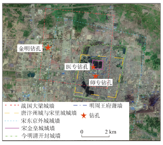 显示原图|下载原图ZIP|生成PPT
图1钻孔位置图
-->Fig. 1Location of the drilling cores
-->
2012年4月,采用DPP-100型岩芯钻机,在3个钻孔位置分别采集25 m连续岩芯样品。样品分样间隔大多为10 cm,少部分在20~30 cm之间,师专、医专和金明钻孔分别获得样品213个、223个和221个,共计657个岩芯样品。
2.2 重金属含量测定方法
将样品在室内自然风干,充分混合后随机多点(约30点)取样约25 g,用玛瑙球磨机反复研磨使之全部通过100目(孔径0.149 mm)尼龙筛,备用。样品Pb、Cd、Cu、Zn、Ni、Cr、Co和Al含量测定的预处理采用HNO3-HF-HClO4消解体系,用XSeries-2型电感耦合等离子体发射质谱仪(ICP-MS,美国Thermofisher)测定Pb、Cd、Cu、Zn、Ni、Cr、Co含量,用6000 Series型电感耦合等离子体发射光谱仪(ICP-AES,美国Thermofisher)测定Al含量。样品As、Hg含量测定的预处理采用王水消解体系,用AFS-3100型双道原子荧光光度计(北京海光)测定其含量。
在试验过程中,采用平行试验、国家标准土壤样品(ESS-2)回收试验进行质量控制。平行试验相对误差在1.27%~10.52%之间,标准样品回收率在91.6%~108.2%之间。
2.3 文化层定年方法
采用14C加速器质谱法(AMS 14C)、考古发掘资料和历史文献记载综合确定文化层年代。14C定年材料包括植物残体、种子、骨头、黏土等,定年工作由北京大学科技考古与文物保护实验室采用AMS 14C方法完成。2.4 文化层重金属积累与污染评价方法
2.4.1 富集系数 用富集系数(enrichment factor, EF)[16]表征文化层各个重金属的富集程度,计算公式为:式中:cn为待测样品重金属n的含量;Bn为背景样品重金属n的含量;cref、Bref分别为待测样品和背景样品参考元素含量。本文选用Al作为参考元素进行EF计算[17-19]。关于重金属背景值的选择,一般选用地壳平均元素丰度[18]。但是,地壳岩石或土壤中的元素含量在不同地区变化很大,地壳平均元素丰度并不适合计算某一局部地区的元素富集状况[20],故有****选用某个国家或区域的元素背景值或少受人类活动影响的对照样含量计算EF[21-22]。战国文化层以下的地层受人类活动影响很小,可近似代表自然沉积层,故本文选用3个钻孔战国以前所有岩芯样品的各个重金属平均含量作为背景值计算EF。3个钻孔战国文化层以下的样品共367个,As、Hg、Cu、Zn、Cd、Pb、Cr、Co和Ni平均含量分别为7.68 mg/kg、0.25 mg/kg、14.81 mg/kg、219.44 mg/kg、0.17 mg/kg、124.15 mg/kg、32.38 mg/kg、6.72 mg/kg、17.29 mg/kg,Al平均含量为56.81 g/kg。根据EF大小可以开展文化层重金属富集程度评价[23-24]:EF<1,无富集;1 ≤ EF<2,轻富集;2 ≤ EF<5,中富集;5 ≤ EF<20,强富集;20 ≤ EF<40,很强富集;EF>40,极强富集。
2.4.2 污染负荷指数 采用污染负荷指数(pollution load index, PLI)[25]评价文化层重金属污染状况,计算公式如下:
式中:CFi为沉积物重金属i的单项污染指数;ci为沉积物重金属i的实测含量;cbi为重金属i的背景值;PLI为某样点多种重金属的污染负荷指数。根据CF和PLI可分别开展单个重金属和某样品多个重金属污染评价。CF的污染分级标准为[7, 26]:CF ≤ 1,无污染;1<CF ≤ 2,轻污染;2<CF ≤ 3,中污染;3<CF ≤ 6,强污染;CF>6,极强污染。PLI的污染分级标准为[27-28]:PLI ≤ 1,无污染;1<PLI ≤ 2,轻污染;2<PLI ≤ 3,中污染;PLI>3,强污染。关于重金属背景值的选取,很多****选用全球页岩重金属含量均值[26, 29],也有些****选取当地背景土壤或沉积物重金属平均含量[30]。为使评价结果更充分地反映开封当地古代人类活动对文化层重金属的影响程度,本文选取3个钻孔战国以前岩芯样品重金属平均含量计算PLI。
3 结果分析
3.1 文化层划分及其年代框架
根据岩芯砂黏比、黑碳和地球化学元素含量,应用小波分析技术,笔者曾综合划分了各钻孔岩芯的沉积旋回[11]。每个沉积旋回代表一次黄河泛滥。黄河泛滥间断期间,当地居民在新近沉积物上从事各种生产和生活活动,便形成文化层。虽然灾后城市重建以及“淘宝”等活动使沉积旋回的正常粒度层序(下粗上细)被强烈扰动,但文化层的有机碳含量必然高于下部地层,颜色也比下部地层要暗一些,这是识别文化层的显著标志。现以师专岩芯为例来说明各文化层与其下部地层的颜色、有机碳含量、质地类型和粒度的差异(表1)。由表1可见,由于城市重建等人类活动对地层混合作用的影响,各文化层与其下部地层的质地类型趋于一致,甚至出现了文化层的砂黏比高于其下部地层的现象。但是,各文化层的颜色和有机碳含量与下部地层仍然存在很大差别。Tab. 1
表1
表1师专岩芯各文化层及其下部地层的理化性状
Tab. 1Physicochemical properties of each cultural layer and its lower sedimentary layer in ZKsz core
| 旋回 | 地层 | 深度范围(m) | 颜色 | 质地类型 | 有机碳(g/kg) | 砂黏比 |
|---|---|---|---|---|---|---|
| 12~13 | 文化层 | 1.4~1.8 | 10YR3/4暗棕 | 粉壤土 | 6.46 | 18.37 |
| 下部沉积层 | 1.8~4.5 | 10YR4/4棕 | 粉壤土 | 4.16 | 13.89 | |
| 11 | 文化层 | 4.5~4.9 | 10YR4/4棕 | 粉土 | 2.79 | 3.45 |
| 下部沉积层 | 4.9~6.0 | 10YR5/4浊黄棕 | 粉土 | 2.65 | 3.69 | |
| 10 | 文化层 | 6.0~6.4 | 10YR4/6棕 | 粉土 | 4.00 | 3.72 |
| 下部沉积层 | 6.4~6.7 | 7.5YR4/4棕 | 粉土 | 3.86 | 1.09 | |
| 9 | 文化层 | 6.7~7.2 | 10YR4/1灰棕 | 粉壤土 | 7.74 | 20.60 |
| 下部沉积层 | 7.2~8.5 | 10YR4/4棕 | 粉壤土 | 5.77 | 15.72 | |
| 8 | 文化层 | 8.5~9.3 | 10YR3/2黑棕 | 粉壤土 | 4.73 | 13.97 |
| 下部沉积层 | 9.3~10.4 | 10YR5/3浊黄棕 | 粉壤土 | 2.48 | 7.40 | |
| 7 | 文化层 | 10.4~10.8 | 10YR4/3浊黄棕 | 粉壤土 | 2.55 | 12.89 |
| 下部沉积层 | 10.8~11.9 | 10YR4/6棕 | 粉壤土 | 1.93 | 6.11 |
新窗口打开
文化层定年的依据主要有以下4个方面:
(1)岩芯14C年龄。师专钻孔有3个14C定年数据,分别在深度7.1 m(1370±20 AD,明初)、8.5 m(1015±35 AD,北宋初)、9.7 m(200±70 AD,东汉至西晋初);医专钻孔仅有1个定年数据,在深度8.0 m(1270±20 AD,金末元初);金明钻孔有4个定年数据,分别在深度7.8 m(1465±35 AD,明初至明中)、9.7 m(1490±40 AD,明中)、13.2 m(920±60 AD,唐末至北宋初)、13.6 m(1095±65 AD,北宋)。
(2)考古发掘资料。自1978年至今,开封市考古工作者对战国大梁城、北宋东京城以及明代周王府等遗址开展了一系列发掘工作,其成果可为本文文化层定年提供有用线索(表2)。
(3)历史文献记载。最早记载黄河泛滥淹没开封城的是《史记·魏世家》中秦王政二十年(225 BC)决鸿沟淹大梁城事件。之后一直到南宋建炎二年(1128年),黄河远离开封城,没有黄河泛滥淹没开封城的记载。自1128年到1855年,随着黄河下游河道逐渐南徙,开封城才多次遭受黄河水患的影响。综合历史文献记载,自战国以来黄泛洪水进入开封内城的事件共有6次,分别发生在225 BC、1387年、1399年、1461年、1642年和1841年;此外,还在1397年、1404年、1410年、1414年、1455年、1478年、1489年等年份发生黄泛洪水围城(洪水进入护城堤与内城之间)事件。
(4)岩芯最下部文化层年代。据最早文字记载,在东周和春秋时期,现今开封城所在位置是一个叫仪邑的小镇。魏惠王六年(364 BC)魏国将都城从安邑迁到大梁,才开始了大规模的城市建设,商业繁荣,人口增加。大梁城直到225 BC才因鸿沟水患而衰落,前后历时140年,形成了开封沉积地层中最早的文化层(砖瓦层),这对于厘清各文化层的年代具有重要参考意义。
Tab. 2
表2
表2钻孔附近考古发现
Tab. 2Archaeological explorations near the drilling cores
| 钻孔 | 文化遗址 | 埋深(m) | 资料来源 |
|---|---|---|---|
| 师专 | 明周王府萧墙 | 3~5 | [31] |
| 宋皇宫宣德门 | 8.2 | [32] | |
| 金皇宫五门 | 6.3 | [10, 32] | |
| 明周王府午门 | 4.5 | ||
| 北宋地面 | 7.5 | [10] | |
| 明代地面 | 4.5 | ||
| 医专 | 明周王府紫禁城端礼门 | 3.5~4 | [33] |
| 明周王府西墙残基 | 5 | ||
| 明周王府地面 | 3~4 | [34] | |
| 金明 | 明代砖块和瓷片 | 4 | [35] |
| 北宋外城堌子门残基 | 8~11 | [10] | |
| 东周陶片 | 12~14 | ||
| 北宋外城西墙墙基 | 11.3 |
新窗口打开
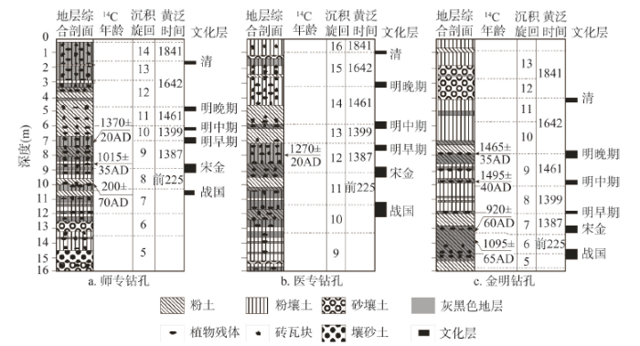
需要指出的是,1642年和1841年的黄河泛滥分别持续了5年和8个月,期间由于黄河来水量的变化以及古地貌的差异,师专和金明钻孔均出现了12和13两个旋回。根据各钻孔最早文化层出露深度,结合AMS14C年龄数据、考古资料、历史文献记载以及地层新老关系,可综合建立各文化层的年代框架(图2)。
 显示原图|下载原图ZIP|生成PPT
图2各钻孔岩芯文化层及其年代框架
-->Fig. 2Cultural layers and their chronological framework of drilling cores
-->
从图2可见,3个钻孔自下而上都存在战国、宋金、明早期、明中期、明晚期和清等6个朝代的文化层。由于受不同时期古地貌、黄河泛滥入城位置以及抗洪能力等差异的影响,各钻孔同一文化层埋深存在一定差别。3个钻孔的战国文化层分别出现在地下10.4~10.8 m、11.1~12.2 m和14.4~15.1 m之间,宋金文化层分别在地下8.5~9.3 m、8.8~9.5 m和12.9~13.3 m之间,明早期文化层分别在地下6.7~7.2 m、7.1~7.6 m和11.9~12.0 m之间,明中期文化层分别在地下6.0~6.4 m、5.7~6.2 m和9.8~10.0 m之间,明晚期文化层分别在地下4.5~4.9 m、2.9~3.3 m和7.7~8.0 m之间,清文化层分别在地下1.4~1.8 m、0.7~1.0 m和4.0~4.2 m之间。
3.2 文化层重金属富集特征
鉴于3个钻孔战国文化层埋深都不超过16 m,且EFCr、EFCo和EFNi随岩芯深度变化较小,故图3只给出0~16 m岩芯Cd、Pb、Cu、Zn、As和Hg的EF以及9种重金属的平均EF(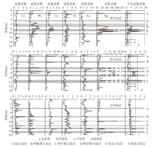 显示原图|下载原图ZIP|生成PPT
图3各钻孔文化层重金属富集系数曲线
-->Fig. 3EF values of heavy metals in drilling cores
-->
大多数文化层各个重金属的EF以及
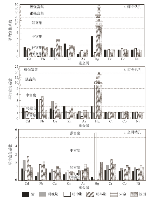
从3个钻孔不同朝代文化层9种重金属的
 显示原图|下载原图ZIP|生成PPT
图4各钻孔不同朝代文化层重金属平均富集系数
-->Fig. 4
-->
3.3 文化层重金属污染分析
3.3.1 文化层重金属综合污染评价 各钻孔不同文化层重金属平均PLI( 显示原图|下载原图ZIP|生成PPT
图5各钻孔文化层重金属污染评价
-->Fig. 5Heavy metal pollution assessment of cultural layers in drilling cores
-->
从3个钻孔不同朝代文化层的重金属平均污染状况来看(图6),各文化层均发生了轻度污染,但明中期以前文化层的
 显示原图|下载原图ZIP|生成PPT
图6各文化层重金属平均
-->Fig. 6
-->
对比城区和郊区文化层重金属污染状况可以发现,除战国和明晚期文化层外,其他文化层的重金属污染程度均表现出城区钻孔高于郊区钻孔的特点。就3个钻孔各文化层的平均
3.3.2 文化层主要污染重金属 从3个钻孔不同文化层各个重金属单项污染指数(表3)的大小可以判别其主要污染重金属。师专钻孔战国、宋金和明早期文化层最主要污染元素是Hg,都达到了极强污染水平,尤其是宋金文化层的CFHg高达52.00,是极强污染下限的8.67倍;其次是Cu和Zn,多在中污染或强污染水平。明中期文化层主要污染元素是Co,达到中污染水平;其次是Cu、Ni和Cd。清文化层主要污染重金属是Hg,达到强污染水平;其次是Zn,达到中污染水平。
Tab. 3
表3
表3各钻孔文化层重金属单项污染指数
Tab. 3Heavy metal CFs of cultural layers in drilling cores
| 钻孔 | 文化层 | 单项污染指数 | ||||||||
|---|---|---|---|---|---|---|---|---|---|---|
| Pb | Cd | Cu | Zn | Hg | As | Cr | Co | Ni | ||
| 师专 | 清 | 0.72 | 1.63 | 1.56 | 2.24 | 3.60 | 0.56 | 1.25 | 1.24 | 1.24 |
| 明晚期 | 0.10 | 1.29 | 1.31 | 1.46 | 0.38 | 0.96 | 1.35 | 1.38 | 1.46 | |
| 明中期 | 1.10 | 1.89 | 1.92 | 1.74 | 1.05 | 1.43 | 1.78 | 2.01 | 1.95 | |
| 明早期 | 1.94 | 1.39 | 3.02 | 2.09 | 28.04 | 0.94 | 1.24 | 1.30 | 1.27 | |
| 宋金 | 1.60 | 1.46 | 3.27 | 2.17 | 52.00 | 1.32 | 1.41 | 1.51 | 1.43 | |
| 战国 | 1.94 | 1.13 | 2.03 | 1.99 | 17.25 | 1.39 | 1.32 | 1.31 | 1.29 | |
| 平均 | 1.23 | 1.47 | 2.19 | 1.95 | 17.05 | 1.10 | 1.39 | 1.46 | 1.44 | |
| 医专 | 清 | 3.52 | 2.01 | 1.80 | 2.27 | 2.25 | 0.96 | 1.29 | 1.25 | 1.19 |
| 明晚期 | 1.26 | 1.36 | 3.26 | 1.42 | 1.05 | 1.36 | 1.01 | 1.19 | 1.16 | |
| 明中期 | 3.99 | 1.45 | 1.68 | 1.18 | 13.36 | 0.44 | 1.39 | 1.40 | 1.35 | |
| 明早期 | 4.17 | 1.31 | 2.78 | 1.54 | 19.27 | 1.50 | 1.26 | 1.17 | 1.06 | |
| 宋金 | 1.03 | 1.20 | 2.09 | 2.42 | 26.70 | 1.90 | 1.50 | 1.54 | 1.43 | |
| 战国 | 1.70 | 1.14 | 1.42 | 1.07 | 10.64 | 1.46 | 1.39 | 1.39 | 1.32 | |
| 平均 | 2.61 | 1.41 | 2.17 | 1.65 | 12.21 | 1.27 | 1.31 | 1.32 | 1.25 | |
| 金明 | 清 | 0.51 | 1.36 | 0.88 | 0.66 | 0.41 | 0.81 | 1.12 | 0.99 | 1.00 |
| 明晚期 | 0.89 | 2.73 | 1.67 | 1.09 | 0.18 | 1.51 | 2.12 | 1.80 | 1.86 | |
| 明中期 | 2.06 | 1.21 | 1.16 | 1.18 | 6.36 | 1.24 | 1.35 | 1.27 | 1.34 | |
| 明早期 | 2.00 | 3.21 | 1.40 | 1.08 | 0.12 | 1.32 | 2.82 | 1.54 | 1.58 | |
| 宋金 | 2.43 | 2.03 | 1.75 | 1.14 | 1.16 | 2.01 | 1.98 | 1.79 | 1.80 | |
| 战国 | 1.63 | 1.78 | 1.69 | 1.04 | 2.53 | 1.75 | 2.35 | 1.82 | 1.80 | |
| 平均 | 1.59 | 2.05 | 1.43 | 1.03 | 1.79 | 1.44 | 1.96 | 1.54 | 1.56 | |
新窗口打开
医专钻孔战国、宋金、明早期和明中期文化层最主要的污染元素也是Hg,都达到了极强污染水平,尤其是宋金文化层的CFHg达到极强污染水平下限的4.45倍;宋金文化层的Cu和Zn处于中等污染水平;明早期和中期文化层的Pb处于强污染水平。明晚期文化层主要污染元素是Cu,达到强污染水平。清文化层主要污染元素是Pb,达到强污染水平;其次是Cd、Zn和Hg,达到中污染水平。
金明钻孔战国文化层主要污染元素是Hg和Cr,宋金文化层是Pb、Cd和As,都处于中等污染水平。明早期文化层是Cd和Cr,分别在强污染和中等污染水平。明中期文化层主要污染元素是Hg,达到极强污染水平;其次是Pb,在中污染水平。明晚期文化层主要污染元素是Cd和Cr,处于中污染水平。
4 讨论
4.1 文化层Hg来源分析
如前所述,师专钻孔的战国、宋金和明早期文化层,医专钻孔的战国、宋金、明早期和明中期文化层,以及金明钻孔的明中期文化层的主要污染元素是Hg,其富集系数都在强富集水平以上,污染程度都达到了极强污染水平。开封古城地下文化层Hg的来源可能与历史时期朱砂(主要成分HgS)的广泛使用有关。开封是历史文化名城,历史上庙宇和宫观众多。尤其是在北宋时期,道教之风盛行,东京城内的宫观和神庙有70余座,与佛教寺院数量相差无几[39-40]。师专钻孔位置就是北宋大内宣德门外御街西侧的景灵西宫所在地。景灵西宫规模宏大,有殿、阁、楼、斋、院等2320区[39]。庙宇和宫观长时间的祭祀和道教信徒的炼丹活动可排放大量Hg[8, 41]。在古代朱砂常被用作装饰或者举行仪式时的大红颜料,且在明朝以前医学家认为朱砂无毒,常将其用作安神定惊的良药而大量制作和使用,也加重了文化层Hg的富集和污染。另外,开封作为八朝古都,宫女、妃嫔及青楼女子众多,其化妆品的使用也会向环境排放Hg[42-43]。4.2 不同朝代文化层重金属污染与人口密度的关系
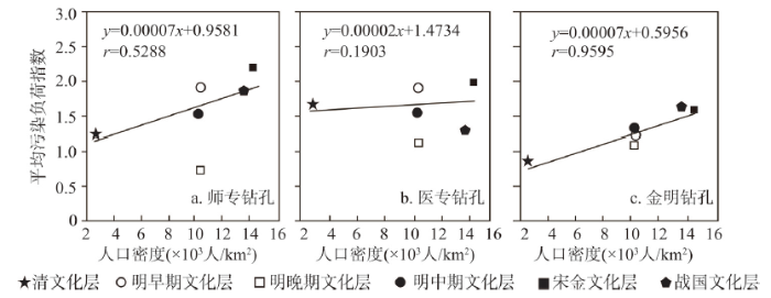
开封古城不同朝代文化层重金属污染程度的差异与不同朝代国民经济发展水平有关。限于历史时期国民经济资料的制约,仅根据《开封县志》[44]和《开封市志》[45]中不甚完整的人口数据,讨论不同朝代文化层重金属污染程度与人口密度的关系。据文献[44]记载,战国大梁城、隋唐汴州城、五代汴州城、北宋东京城、金汴京城、明开封城的城市人口密度分别为13600人/km2、2100人/km2、15000人/km2、35552人/km2、1000人/km2和10277人/km2。宋金文化层是多个朝代(秦汉—元初)的混合地面,但因缺少秦汉、三国、两晋等历史时期的人口数据,故应用隋唐汴州城、五代汴州城、北宋东京城、金汴京城人口密度数据,按照相应朝代历时长短进行加权计算得到宋金文化层对应的人口密度,为14330人/km2。由于缺乏开封明朝不同历史时期的人口密度数据,故将明早、中、晚期文化层对应的人口密度均定为10277人/km2。文献[44]和[45]记载,开封城区在清朝初年、康熙三十年(1691年)、康熙五十年(1711年)和乾隆十六年(1751年)的人口密度分别为1134人/km2、2268人/km2、2835人/km2和3402人/km2。自1751年至1841年黄河泛滥之前的90年间,目前没有查到人口数据。考虑到清文化层是从1642年黄泛后至1841年黄泛前形成的,因此本文将清朝初期至1841年间的人口密度数据按照历时长短进行加权计算得到清文化层对应的人口密度,为2616人/km2。
从3个钻孔各个文化层
 显示原图|下载原图ZIP|生成PPT
图7各钻孔文化层重金属污染与人口密度的关系
-->Fig. 7The linear correlation between
-->
4.3 明早、中、晚期文化层重金属污染差别原因分析
各钻孔明早、中、晚期文化层的5 结论
(1)现今开封城下存在战国、宋金、明早期、明中期、明晚期和清代等6个朝代的文化层。(2)城区钻孔(师专和医专钻孔)岩芯的重金属平均富集系数大于郊区钻孔(金明钻孔),且师专钻孔(2.04,中富集)>医专钻孔(1.57,轻富集)>金明钻孔(1.05,轻富集)。文化层中的大部分重金属含量高于其上部和下部的黄泛地层,富集明显。富集元素主要是Hg、Cu、Zn、Pb、Cd和As,其中以Hg富集最为明显,城区钻孔明早期以前文化层的Hg达到强富集至极强富集水平,而Cr、Co和Ni富集不明显。
(3)宋金文化层重金属污染最为严重,其他依次是明早期、战国、明中期、清和明晚期文化层。除金明钻孔的清文化层和师专钻孔的明晚期文化层没有发生污染外,其他文化层都发生了轻度至中度污染,中度污染出现在师专和医专钻孔的宋金文化层。城区钻孔各文化层平均污染程度大于郊区钻孔。不同钻孔各朝代文化层的主要污染重金属存在一定差别,城区钻孔的最主要污染重金属是Hg,其次是Cu、Pb和Zn;郊区钻孔的主要污染重金属是Cd、Cr、Hg和Pb。文化层中的Hg与历史时期人们对朱砂的广泛使用有关。
(4)不同朝代文化层重金属积累和污染程度的差别主要受历史时期人类活动强度(如人口密度)影响,明早、中、晚期文化层的污染程度逐渐减弱还与明朝开封城复兴与频繁的黄河泛滥密切相关。
(5)本文仅以不甚完整的人口密度数据讨论了不同朝代人类活动与文化层重金属污染之间的关系,研究结论只是初步的。实质上影响文化层重金属积累和污染的因素还有很多,今后应进一步收集资料,开展不同朝代各钻孔岩芯点位的土地利用方式与文化层重金属积累和污染关系研究。
The authors have declared that no competing interests exist.
参考文献 原文顺序
文献年度倒序
文中引用次数倒序
被引期刊影响因子
| [1] | Determination of copper concentrations in Greenland ice dated from seven millennia ago to the present showed values exceeding natural levels, beginning about 2500 years ago. This early large-scale pollution of the atmosphere of the Northern Hemisphere is attributed to emissions from the crude, highly polluting smelting technologies used for copper production during Roman and medieval times, especially in Europe and China. This study opens the way to a quantitative assessment of the history of early metal production, which was instrumental in the development of human cultures during ancient eras. |
| [2] | Lake Cobu00e1, within the archaeological site of Cobu00e1, provides evidence bearing on lowland Maya development. Palynological and geochemical data record multidecadal precipitation cycles from a 8.80-m, >8370-yr lake-sediment sequence terminating on bedrock. Late Classic sedimentation rates are rapid, but an anthropogenically derived colluvium layer is lacking. Initial vegetation was medium semi-deciduous and swamp forest. Forest clearance began 1650 B.C. (Early Preclassic) and maize first occurred at 850 B.C. (Middle Preclassic). Lakeside milpas existed until A.D. 720 (Late Classic) and then were moved from the city center as urbanization intensified and Lake Cobu00e1 was diked as a reservoir. Cobu00e1 was at most briefly vacated during the Classic Collapse and was abandoned after A.D. 1240, although some habitation persisted. The paleoecological record matches the archaeological history for Cobu00e1, but pervasive disturbance muted the climatic signal, as the Late Classic drought is barely evident. The question whether economic trees were maintained within the city is unresolved. Maize cultivation allowed the Maya to develop a complex society and support a large population, but dependence on maize was ultimately doomed by variable rainfall. Precipitation in extreme years was insufficient to support crops, while native vegetation was not directly affected by drought that devastated Maya agriculture. |
| [3] | Urban soils in the central part of Moscow consist of a thick layer of municipal waste (the cultural layer). Its thickness varies from 2 to 5 m and can reach 20 m in depressions. It has been affected by pedogenic processes and also contains archaeological artefacts. Thus, it is simultaneously a soil, a sediment and a cultural layer. It is very stony, has a strongly alkaline reaction and is enriched in organic matter (30-fold increase in comparison with surface soils of Moscow suburbs), carbonates, phosphorus compounds (20–200-fold increase) and various microelements (Pb, Cu, Zn, As, 100–1000-fold increase). |
| [4] | 通过对安徽巢湖东部含山凌家滩遗址的野外调查、地层采样和元素地球化学分析,结合年代学和文物考古成果,综合研究表明:1)元素迁移的剖面特征总体反映了凌家滩遗址地层由下至上脱硅富铝铁程度渐弱的趋势,符合亚热带地区风化成土的脱硅富铝化过程及特征;2)晚更新世末堆积的红褐色黏土层顶部是凌家滩人生活的古地貌面,早中全新世沉积速率较低,一方面与适宜期高温高湿的气候条件有关,另一方面也与间歇性的构造抬升运动有关;汉代和明清时期,由于受到晚全新世气候向干冷变化的影响,发生了一定规模的风成堆积;明清文化层虽然受到人类活动的影响,但在元素地球化学特征上依然反映出气候变化的因素;3)凌家滩遗址剖面下部的晚更新世沉积地层是以粉尘、风化型黏土为母质的风化层,它的特征介于下蜀黄土和风化壳黏土之间;遗址地层晚更新世沉积的岩性和化学组成代表的风化强度都超过了该区正常的下蜀黄土地层和其中的弱古土壤层。 . 通过对安徽巢湖东部含山凌家滩遗址的野外调查、地层采样和元素地球化学分析,结合年代学和文物考古成果,综合研究表明:1)元素迁移的剖面特征总体反映了凌家滩遗址地层由下至上脱硅富铝铁程度渐弱的趋势,符合亚热带地区风化成土的脱硅富铝化过程及特征;2)晚更新世末堆积的红褐色黏土层顶部是凌家滩人生活的古地貌面,早中全新世沉积速率较低,一方面与适宜期高温高湿的气候条件有关,另一方面也与间歇性的构造抬升运动有关;汉代和明清时期,由于受到晚全新世气候向干冷变化的影响,发生了一定规模的风成堆积;明清文化层虽然受到人类活动的影响,但在元素地球化学特征上依然反映出气候变化的因素;3)凌家滩遗址剖面下部的晚更新世沉积地层是以粉尘、风化型黏土为母质的风化层,它的特征介于下蜀黄土和风化壳黏土之间;遗址地层晚更新世沉积的岩性和化学组成代表的风化强度都超过了该区正常的下蜀黄土地层和其中的弱古土壤层。 |
| [5] | . |
| [6] | Multi-element soil analysis is now an established technique in archaeology. It has been used to locate archaeological sites and define the extent of human activity beyond the structural remains, and to aid interpretation of space use in and around archaeological remains. This study aimed to evaluate the consistency of these soil element signatures between sites and hence their potential usefulness in archaeological studies. Known contexts on abandoned farms across the UK were sampled to test the relationships between element concentrations and known functional area and to assess inter-site variability. The results clearly show that there are significant differences in the soil chemistry of contrasting functional areas, particularly for Ba, Ca, P, Zn, Cu, Sr and Pb. Despite significant site specific effects, which appear to reflect individual anthropogenic practices rather than geological influences, there is sufficient similarity in the pattern of element enhancement to allow reliable interpretation of former function using discriminant models. Relating these enhancements to precise soil inputs, however, is more problematic because many important soil inputs do not contain distinct element fingerprints and because there is mixing of materials within the soil. There is also a suggestion that charcoal and bone play an important role in both the loading and post-depositional retention of Ca, Sr, P, Zn, and Cu and thus may be significant in the formation of soil element concentration patterns. |
| [7] | 通过对苏北梁王城遗址地层中Cu、Zn、Pb、Cr、Ni和Al的含量进行电感耦合等离子体原子发射光谱(ICP-AES)测试,评价该遗址不同历史时期重金属污染程度。单个重金属污染程度从大到小依次是CuZnPbNiCr。不同历史时期各个单个金属污染程度不同。Cu的污染程度最大出现在战国、北朝和宋代;而Zn的污染程度最大出现在北朝;文化层中Pb污染程度变化不明显;Ni和Cr各个历史时期污染程度没有什么明显变化。重金属综合污染程度在大汶口文化时期开始增大,到战国时期达到最大,污染程度接近中度污染水平,然后开始减小。富集因子Enrichment Facto(rEF)研究表明Cu、Zn主要受人类活动影响;Ni、Cr来源相似主要来自母质风化;重金属Pb既有部分来自人类活动,又有部分来自母质风化;明清文化层中Pb的富集系数有上升的趋势,这可能与Fe大量冶炼和Pb使用量增大有关。金属冶金技术和金属使用情况有关因素可能是影响遗址地层重金属污染程度的主要因素。 . 通过对苏北梁王城遗址地层中Cu、Zn、Pb、Cr、Ni和Al的含量进行电感耦合等离子体原子发射光谱(ICP-AES)测试,评价该遗址不同历史时期重金属污染程度。单个重金属污染程度从大到小依次是CuZnPbNiCr。不同历史时期各个单个金属污染程度不同。Cu的污染程度最大出现在战国、北朝和宋代;而Zn的污染程度最大出现在北朝;文化层中Pb污染程度变化不明显;Ni和Cr各个历史时期污染程度没有什么明显变化。重金属综合污染程度在大汶口文化时期开始增大,到战国时期达到最大,污染程度接近中度污染水平,然后开始减小。富集因子Enrichment Facto(rEF)研究表明Cu、Zn主要受人类活动影响;Ni、Cr来源相似主要来自母质风化;重金属Pb既有部分来自人类活动,又有部分来自母质风化;明清文化层中Pb的富集系数有上升的趋势,这可能与Fe大量冶炼和Pb使用量增大有关。金属冶金技术和金属使用情况有关因素可能是影响遗址地层重金属污染程度的主要因素。 |
| [8] | 分析古土壤性质是获取古环境信息的重要手段,通过研究文化遗址区古土壤性质来反映古环境和古人类活动日益成为国内外研究的热点。系统地总结了近年来国内外文化遗址区古土壤的土壤粒度、土壤微型态、土壤元素、土壤磁化率、多环芳烃、动植物遗存等在考古应用方面的研究进展,结果表明上述研究方法有效地反映古环境信息和古人类活动。提出了应借鉴相关研究指标,进一步加强土壤学与考古学的结合,在此基础上丰富文化遗址区古土壤研究方法,加强对文化遗址区土壤的分类研究,逐步建立考古土壤学这一新的学科分支。 . 分析古土壤性质是获取古环境信息的重要手段,通过研究文化遗址区古土壤性质来反映古环境和古人类活动日益成为国内外研究的热点。系统地总结了近年来国内外文化遗址区古土壤的土壤粒度、土壤微型态、土壤元素、土壤磁化率、多环芳烃、动植物遗存等在考古应用方面的研究进展,结果表明上述研究方法有效地反映古环境信息和古人类活动。提出了应借鉴相关研究指标,进一步加强土壤学与考古学的结合,在此基础上丰富文化遗址区古土壤研究方法,加强对文化遗址区土壤的分类研究,逐步建立考古土壤学这一新的学科分支。 |
| [9] | . |
| [10] | |
| [11] | |
| [12] | . |
| [13] | 多次黄河泛滥使现今开封城市地面以下叠置数座古城,出现"城摞城"奇观。泛滥之后的城市重建等人类活动常常扰动正常的沉积层序,给粒度旋回划分带来巨大困难,因此需要寻找其他代用指标。分别在"城摞城"中心区(ZKsz)和郊区(ZKjm)获取25 m连续岩芯,以10 cm间隔分样;用激光粒度法结合筛分开展沉积物粒度分析,用Lim法(1996)测定黑碳含量,用小波分析划分沉积旋回。结果表明:ZKjm岩芯的粒度旋回界线大多与黑碳旋回一致,表明黑碳含量可以作为划分沉积旋回的代用指标。ZKsz钻芯深度8.8~23.5 m之间的地层,粒度旋回和黑碳旋回的数量及其界限基本相同;北宋以后地层(深度0.3~8.8 m)的粒度旋回只有2个,而黑碳旋回有7个,表明黑碳含量适用于城市扰动地层的沉积旋回划分。 . 多次黄河泛滥使现今开封城市地面以下叠置数座古城,出现"城摞城"奇观。泛滥之后的城市重建等人类活动常常扰动正常的沉积层序,给粒度旋回划分带来巨大困难,因此需要寻找其他代用指标。分别在"城摞城"中心区(ZKsz)和郊区(ZKjm)获取25 m连续岩芯,以10 cm间隔分样;用激光粒度法结合筛分开展沉积物粒度分析,用Lim法(1996)测定黑碳含量,用小波分析划分沉积旋回。结果表明:ZKjm岩芯的粒度旋回界线大多与黑碳旋回一致,表明黑碳含量可以作为划分沉积旋回的代用指标。ZKsz钻芯深度8.8~23.5 m之间的地层,粒度旋回和黑碳旋回的数量及其界限基本相同;北宋以后地层(深度0.3~8.8 m)的粒度旋回只有2个,而黑碳旋回有7个,表明黑碳含量适用于城市扰动地层的沉积旋回划分。 |
| [14] | . |
| [15] | 根据开封市西郊9 m岩芯样品的孢粉分析,结合AMS14C测年、粒度分析和历史文献,揭示区域植被对"崇祯大旱"事件的响应。结果表明,岩芯深度0~1.8 m为20世纪中叶的黄河灌淤层和近期堆垫层,1.8~4 m和4~7.8 m分别为1841年和1642-1644年的黄泛沉积;岩芯存在7.8~9 m、5~7.8 m、2~5 m和0~2 m等4个孢粉带,其中5~7.8 m的孢粉带记录了明末"崇祯大旱"事件。该层段下段(6.7~7.8 m)为黄泛早期沉积物,木本植物花粉减少至整个岩芯的最低值,而藜科花粉比例显著升高并占据绝对优势,同时还伴随有旱生植物白刺属和麻黄属花粉出现,蒲公英属和菊科等耐旱植物花粉含量也相对较高,指示一次干旱事件;上段(5~6.7 m)为黄泛后期沉积物,木本植物尤其是松属花粉含量较高,而藜科等旱生植物花粉相对较少,可能是由于松属等木本植物花粉悬浮能力强而被洪水携带至下游,在水流缓慢或近于滞流时沉积,再加上洪水过后黄泛地面接受当地源、区域源和区域外源花粉的缘故。 . 根据开封市西郊9 m岩芯样品的孢粉分析,结合AMS14C测年、粒度分析和历史文献,揭示区域植被对"崇祯大旱"事件的响应。结果表明,岩芯深度0~1.8 m为20世纪中叶的黄河灌淤层和近期堆垫层,1.8~4 m和4~7.8 m分别为1841年和1642-1644年的黄泛沉积;岩芯存在7.8~9 m、5~7.8 m、2~5 m和0~2 m等4个孢粉带,其中5~7.8 m的孢粉带记录了明末"崇祯大旱"事件。该层段下段(6.7~7.8 m)为黄泛早期沉积物,木本植物花粉减少至整个岩芯的最低值,而藜科花粉比例显著升高并占据绝对优势,同时还伴随有旱生植物白刺属和麻黄属花粉出现,蒲公英属和菊科等耐旱植物花粉含量也相对较高,指示一次干旱事件;上段(5~6.7 m)为黄泛后期沉积物,木本植物尤其是松属花粉含量较高,而藜科等旱生植物花粉相对较少,可能是由于松属等木本植物花粉悬浮能力强而被洪水携带至下游,在水流缓慢或近于滞流时沉积,再加上洪水过后黄泛地面接受当地源、区域源和区域外源花粉的缘故。 |
| [16] | Abstract Arsenic content in the cultivated soils of an area affected by long-range atmospheric transport from the Upper Silesian Industrial Region (southern Poland) and point emission sources (coal mine) was 8.7 mg/kg on average. The calculated index of geoaccumulation pointed to moderate arsenic contamination of the soil. The enrichment factor calculated as a ratio between arsenic content in the soil and arsenic content in the earth crust applying the logarithmic values of reference elements (i.e. chromium and calcium) also classi-fied the soil as moderately contaminated with arsenic. |
| [17] | Anthropogenic trace element contamination of soils in the densely populated and industrialized Nord-Pas de Calais region (France) was quantified using enrichment factors (EFs). Total concentrations of Al and 18 trace elements (As, Bi, Cd, Co, Cr, Cu, Hg, In, Mn, Mo, Ni, Pb, Sb, Se, Sn, Tl, V, and Zn) were determined in 252 sampling sites both in topsoil and deep horizons of soils developed from sedimentary materials. Thus, at each sampling site an enrichment factor was computed for each of the 18 trace elements as the ratio between total concentrations of the trace element in topsoil and deep horizons in the same soil pit, normalized by concentrations of Al measured in the same horizons and the same pit. To estimate EF values at unsampled locations and then to assess the spatial magnitude of anthropogenic trace element contamination over the whole study area (12 400 km 2 ), variography analysis was used to quantify the spatial structure of each EF. Results have shown that values of 8 EFs are spatially correlated. These EFs were thus mapped using the sequential Gaussian simulation technique. One hundred horizon samples from 50 supplementary sites were analysed for the structured trace elements and Al contents and used for the mapping validation. Results of the validation based on the accuracy plots and goodness statistics ( G and D ) allowed us to conclude that EF maps exhibited high certainty in regard to the validation data set. In addition, results have shown that E-type estimates were accurate when they are used to estimate the measured EF value of the validation data set. Accordingly, these maps were used to discuss the origin of patches of surface horizon enrichment displaying an exogenous input of the trace elements investigated. The whole study area under discussion is strongly enriched with cadmium, originating from both industrial and agricultural activities. Surface horizons also exhibit locally high levels of Pb and Zn enrichment, mainly around well-known former or current industrial sites. However, Pb and Zn enriched surface horizons are far less widespread than those enriched in Cd. Higher Cu, Bi and Sn EF values were observed in the northern part of the region studied than in the southern part. The dissimilarity underlined a rather diffuse contamination from the urbanized zone in the north to the rural zone in the south of the region. The enrichment of surface horizons by In and Tl seems insignificant. Some unstructured EFs were attributes to point-source enrichments. |
| [18] | The objective of this study was to investigate the vertical distribution of rare earth elements (REEs) in a natural wetland soil core to understand the influence of natural and anthropogenic activities on geochemical behavior of REEs. A natural wetland soil core of 95 cm was collected from the Sanjiang Plain in China and sliced into 5 cm slices for analyses of REEs, Fe, Al, Mn, Sc, Y, and soil organic matter (SOM). Results indicated that SOM was accumulated in the upper part of the soil core (0 to 20 cm depth), while Fe and Mn was reductively leached from the upper part of the soil core and accumulated in the low part. The content of total REEs ranged from 137.9 to 225.9 mg/kg in the soil core. Content profiles obtained for all REEs were almost identical except for Ce. The highest contents of REEs generally occurred at about 20 cm depth, but enrichment factor (EF) of REEs except Ce was usually the highest in the surface horizon. Average EF ranged from 1.1 for La to 2.1 for Gd. The pronounced shift in EF occurred at about 40 cm depth and it gradually increased from 40 cm depth to surface (except for Ce), probably suggesting anthropogenic atmospheric deposition of REEs. In comparison with chondrite, Eu was depleted in all horizons, while Ce was negatively anomalous in the top horizons and positively anomalous in the bottom horizons. This positive anomaly of Ce in the bottom horizons was due to its preferential adsorption on Fe and Mn oxides, relative to other REEs. Although both natural and anthropogenic activities influence the geochemical behaviors of REEs in soils, enrichment or mobility of REEs is low in the natural wetland soil core of the Sanjiang Plain. |
| [19] | |
| [20] | High element enrichment factors (EFs) are commonly used in the literature to support the hypothesis that a particular suite of elements is of anthropogenic origin. Real-world examples of regional geochemical surveys demonstrate that EFs can be high or low due to a multitude of reasons, of which contamination is but one. This applies to EFs calculated relative to either the crust or some local background (e.g., a deeper soil layer). Results from local studies near industrial centres showing high (and pollution-related) EFs cannot be generalised over large areas or for sample sites far removed (i.e., more than some tens of kilometers) from a likely pollution source. Regional-scale geochemical mapping, on the other hand, facilitates the reliable estimation of the influence of contamination on the measured element concentrations. EFs are strongly influenced by, among other factors, biogeochemical processes that redistribute chemical elements between environmental compartments at the Earth's surface. Using EFs to detect or rove human influence on element cycles in remote areas should be avoided because, in most cases, high EFs cannot conclusively demonstrate, nor even suggest, such influence. |
| [21] | An assessment was conducted on soils of Ibadan metropolis using geochemical approach in order to establish the concentration of heavy metals and develop geoaccumulation index maps. Petrographic studies and X-ray diffractograms showed that soils of Ibadan were derived from the weathering of the bedrocks. The concentrations of Cu, Pb, and Zn were found to be greater in soils more than the background. Positive correlation occurred between Cu, Pb, and Zn indicated a common anthropogenic source in the soil while Mn, Cr, and Ni were found to be naturally enriched. The geoaccumulation index maps revealed significant enrichment factor (Ef>20) and index of geoaccumulation (Igeo) beyond class four (heavily contaminated) for Cu, Pb, and Zn in densely populated and industrial areas, whereas Cd is enriched in sparsely populated areas, agricultural areas and a few spots in densely populated areas. |
| [22] | Abstract Street dusts collected from Baoji, NW China were analyzed for Cu, Pb, Zn, Mn and Ni by using PANalytical PW-2403 wavelength dispersive X-ray fluorescence spectrometry and assessed the contamination level of heavy metals on the basis of geoaccumulation index (I(geo)), enrichment factor (EF), pollution index (PI) and integrated pollution index (IPI). The results indicate that, in comparison with Chinese soil, street dusts in Baoji have elevated metal concentrations as a whole. The concentrations of heavy metals investigated in this paper are compared with the reported data of other cities. The calculated results of I(geo) and EF of heavy metals reveal the order of I(geo) and EF are Pb>Zn>Cu>Ni>Mn. The high I(geo) and EF for Pb, Zn and Cu in street dusts indicate that there is a considerable Pb, Zn and Cu pollution, which mainly originate from traffic and industry activities. The I(geo) and EF of Mn and Ni are low and the assessment results indicate an absence of distinct Mn and Ni pollution in street dusts. The assessment results of PI also support Pb, Zn and Cu in street dusts presented serious pollution, and IPI indicates heavy metals of street dust polluted seriously. |
| [23] | This study was conducted to assess the level of contamination of surface dust from paved roads. Dust samples were collected from major and busy roads in the city of Accra Ghana. Elemental analysis of road dust has been carried out in this study using energy dispersive X-Ray fluorescence analysis to identify the possible anthropogenic sources of pollutants in road dust. The elements Ti, V, Cr, Mn, Ni, Cu, Zn, Br, Zr and Pb were among 20 elements identified. The mathematical models; Index of geoaccumulation (Igeo), Enrichment Factors (EF), Contamination factor and degree of contamination were used to identify possible levels of pollution from anthropogenic sources. The results showed that the build of manganese, which is used instead of lead (Pb), as an octane enhancer has not gone above the crustal levels. However, significant Pb contamination was observed in the road dust. All the models agreed well in their results giving moderate to significant levels of pollution for the most part of the selected sites. The results of the Principal Component Analysis gave three major sources contributing to road dust. These are the natural crustal source, vehicular emissions and corroded vehicular parts. |
| [24] | 利用在南海西北部北部湾和海南岛周边海域采集的492个站位的底质沉积物样品,以同一海区内同时采集的柱状样品的底层样品和"清洁区"样品中各重金属元素含量值作为背景值,运用潜在生态危害指数法、沉积物富集系数法和ArcGIS软件,对其Cd、Zn、Pb、Cu和Cr 5种重金属元素分布特征及其上述2种污染指数的分布图进行了分析和比较,对该区污染现状和趋势进行了评价,结果表明:研究区底质沉积物5种重金属元素中,Cd元素的污染程度为最高,Cr元素的污染程度为最低,北部湾中东部为污染较为严重的地区,各港区污染程度排序为:北海港区铁山港区防城港区钦州港区,其重金属元素的主要来源可能为雷州半岛西岸及广西沿岸的个别港区频繁的人为活动和陆源河流的输入。由此可见,南海北部的北海港区、铁山港区和北部湾中东部海区,将是未来污染严重的区域,故也是污染监测和防治的主要区域;同时,北部湾的西部和海南岛的部分周边海域,虽目前尚无污染,但却已有污染趋势,故也应作为今后环境监测工作的重点区域,防止污染程度的进一步加剧。 . 利用在南海西北部北部湾和海南岛周边海域采集的492个站位的底质沉积物样品,以同一海区内同时采集的柱状样品的底层样品和"清洁区"样品中各重金属元素含量值作为背景值,运用潜在生态危害指数法、沉积物富集系数法和ArcGIS软件,对其Cd、Zn、Pb、Cu和Cr 5种重金属元素分布特征及其上述2种污染指数的分布图进行了分析和比较,对该区污染现状和趋势进行了评价,结果表明:研究区底质沉积物5种重金属元素中,Cd元素的污染程度为最高,Cr元素的污染程度为最低,北部湾中东部为污染较为严重的地区,各港区污染程度排序为:北海港区铁山港区防城港区钦州港区,其重金属元素的主要来源可能为雷州半岛西岸及广西沿岸的个别港区频繁的人为活动和陆源河流的输入。由此可见,南海北部的北海港区、铁山港区和北部湾中东部海区,将是未来污染严重的区域,故也是污染监测和防治的主要区域;同时,北部湾的西部和海南岛的部分周边海域,虽目前尚无污染,但却已有污染趋势,故也应作为今后环境监测工作的重点区域,防止污染程度的进一步加剧。 |
| [25] | Most estuaries receive a high heavy-metal input from industries. This is reflected in the relatively high levels found in numerous estuarine organisms and in sediments. Many indicators have been suggested for facilitating the detection of heavy-metal pollution, but the problems in using these indicators to evaluate the metal loading of estuaries are considerable. Variations in species composition, and conditions at different sites, differences in season of sampling, and age of organism, as well as different metal levels in different parts of the organism, make the interpretation of results difficult. The levels reported here, similar to those in other unpolluted estuaries, have been used to suggest a baseline concentration for heavy metals in estuaries. The concept of a baseline is fundamental to the formation of a “Biological Quality Index” and “Pollution Load Index,” and a formula for such an index is suggested and tested at a preliminary level against published data for an English and a European estuary. |
| [26] | Increasing air pollution levels due to rapid urbanization and growth in vehicular emission have become a major source of concern. As a result, research on air pollution in urban environments has largely focused on road deposited dust. In the present study, road deposited dust samples collected from the Ketu-South District, Volta Region in Ghana were analyzed for heavy metals (As, Cr, Cu, Mn, Ni, Pb and Zn) using energy dispersive XRF. The ranges of metal concentration were: 0.4-18.2 μg/g for As; 284-9106 μg/g for Cr; 18.4-144.1 μg/g for Cu; 233-1240 μg/g for Mn; 12.3-493.2 for Ni; 3.1-67.8 μg/g for Pb; and 18.2-406.5 μg/g for Zn. The highest level of metal contamination was found in the only roadway of an industrial area (cement factory). The lowest contaminated site was noted in a roadway which runs through a host of rural communities. Inter-cities comparison with previous data established that Cr levels in the present study was very high while Pb was very low compared to other cities. Metal contamination assessment status of the metals was made using mathematical models in terms of enrichment factor, geoaccumulation index and contamination factor. All the models agreed that contamination levels is in increasing order of Mn>Ni>Cu>Pb>Zn>As>Cr. |
| [27] | . |
| [28] | The characterization of heavy metal pollution is urgently needed in modern environmental studies. However, traditional geochemical methods for detecting soil heavy metals are rather time-consuming and expensive. In recent years, non-destructive and rapid magnetic techniques seem promising in monitoring soil pollution but it is questionable how this relates to heavy metal concentrations. Therefore, in order to understand the correlation of heavy metal pollution with environmental magnetism, magnetic susceptibility (χ LF ) and the concentrations of As, Cd, Cr, Cu, Ni, Pb and Zn were measured in the topsoil (0–1502cm) collected from Kaifeng City, China. In this study, the spatial distribution of heavy metals and χ LF , as well as the correlation between pollution load index ( PLI ) and χ LF were carried out. Results show that the contamination factor ( CF ) values of different heavy metals follow the order: Cd (10.48)02>02Zn (2.28)02>02Pb (1.68)02>02Cu (1.51)02>02Ni (0.81)02>02Cr (0.80)02>02As (0.65). The average pollution load index ( PLI ) of the metals is 2.53, representing a moderate pollution level as a whole of the city soil. In general, similar spatial distribution patterns of heavy metals and χ LF were found in this research, which decrease progressively from the southeast/east to the northwest/west in the study area. High concentrations of heavy metals and high levels of χ LF appears around the southeast, the north of the older city (within the ancient city wall), and along the Longxi–Haizhou Railway. Moreover, contents of As, Cd, Cr, Cu, Ni, Pb and Zn in soils and PLI are significantly positively correlated with their χ LF . The results further attest that the measurement of χ LF is a simple, rapid and quantitative method for the assessment of heavy metal contamination of soils. When χ LF 02≤027102×0210 61028 02m 3 02kg 61021 , the soil is considered to be non-polluted; 7102×0210 61028 02<02χ LF 02≤0216202×0210 61028 02m 3 02kg 61021 represents slightly polluted soils; 16202×0210 61028 02<02χ LF 02≤0225302×0210 61028 02m 3 02kg 61021 moderate pollution, and χ LF 02≥0225302×0210 61028 02m 3 02kg 61021 corresponds to heavily polluted soils. However, the standard is exclusively valid for the study area and cannot be simply “transferred” to other polluted areas. |
| [29] | Cr, Co, Cu, Zn, Cd and Pb in the bottom sediments from 93 sites at Quiberon bay were analyzed by Inductively Coupled Plasma Mass Spectrometry (ICPMS) after acid extraction. The ranges of the concentration in the sediments are as follows: 27.3 08g/g (Cr), 11.6 08g/g (Co), 13.8 08g/g (Cu), 42.0 08g/g (Zn), 0.08 08g/g (Cd) and 17.8 08g/g (Pb). Potential contamination of the bay was assessed by Igeo and pollution load index whether the concentration observed represent background or contaminated levels. Based on the results, it can be concluded that the bay is unpolluted for the studied metals. |
| [30] | This paper focuses on heavy metal (Co, Cu, Fe, Pb, Mn, Ni and Zn) enrichment and degree of contamination in the soils windward of the Selebi Phikwe copper and nickel mine (eastern Botswana). Pollution by these metals was examined using several calculation methods: enrichment factors, modified degree of contamination, pollution load index and geoaccumulation index. Enrichment factors were further assessed by comparing present day soil metal contents obtained using actual Fe content in standard earth material obtained from literature with that measured in soils sampled from areas adjacent to the site of concern to represent ncontaminated background concentrations. The latter method was found to be the most relevant and the normalised enrichment values demonstrate moderate enrichment of Cu and Ni. The proposed modified calculation method of degree of contamination, which involves determination of arithmetic mean of contamination factors by individual studied metals, revealed moderate contamination by metals. The PLI, which basically is a measure of site quality, indicated deterioration due to metal contamination. These results were further supported by values obtained from indices of geoaccumulation method of pollution assessment. Principal component analysis at windward site of the mine extracted two major components: 1. high positive loading of Pb, Ni, Cu and Zn associated with anthropogenic influence by smelter emissions and 2.high positive loadings of Co, Mn and Fe are associated with contributions from natural processes. This evaluation would serve to create consistent calculation methods as a contribution towards building a consensus on methodologies applicable to the study of polluted soils. |
| [31] | . 北宋东京皇宫二城考略李合群北宋定鼎中原,以开封为国都,其皇宫源于唐宣武军节度使衙署。后梁改此衙署为建昌宫,后晋时又更作大宁宫。后周世宗即位后,虽对其进行了一些营缮,但“犹未如王者之制”①。在五代皇宫的基础上,宋廷于太祖建隆三年(962年),对北宋皇宫... . 北宋东京皇宫二城考略李合群北宋定鼎中原,以开封为国都,其皇宫源于唐宣武军节度使衙署。后梁改此衙署为建昌宫,后晋时又更作大宁宫。后周世宗即位后,虽对其进行了一些营缮,但“犹未如王者之制”①。在五代皇宫的基础上,宋廷于太祖建隆三年(962年),对北宋皇宫... |
| [32] | . . |
| [33] | . . |
| [34] | . 20世纪80年代,开封宋城考古队(现为开封市文物工作队)对北宋东京城皇宫遗址进行了考古勘探和试掘,在今开封龙亭公园及其周围一带发现了明代开封周王府遗址的部分遗迹,基本确定了其萧墙、紫禁城两重城垣和部分门址的位置,并对萧墙北墙、紫禁城北墙和紫禁城内的部分区域进行了试掘,获得了一批重要的考古资料,对明开封周王府遗址有了初步的认识。但截至目前,有关开封宋皇宫遗址和明周王府遗址的考古报告尚未正式出版, . 20世纪80年代,开封宋城考古队(现为开封市文物工作队)对北宋东京城皇宫遗址进行了考古勘探和试掘,在今开封龙亭公园及其周围一带发现了明代开封周王府遗址的部分遗迹,基本确定了其萧墙、紫禁城两重城垣和部分门址的位置,并对萧墙北墙、紫禁城北墙和紫禁城内的部分区域进行了试掘,获得了一批重要的考古资料,对明开封周王府遗址有了初步的认识。但截至目前,有关开封宋皇宫遗址和明周王府遗址的考古报告尚未正式出版, |
| [35] | . |
| [36] | Highways and main roads are a potential source of contamination for the surrounding environment. High traffic rates result in elevated heavy metal concentrations in road runoff, soil and water seepage, which has attracted much attention in the recent past. Nonetheless, investigations of pollutants in roadside soils are still a subject of major interest due to the rapid development of traffic systems and increasing traffic all over the world. The accumulation of the heavy metals Pb, Cd, Cu and Zn in soils along the oldest federal highway of the world has been studied by sampling a roadside transect of 125 by 10 m. In addition, heavy metal concentrations of Pb, Cd, Zn, Cu, Ni and Cr in soil solutions from different distances (2.5, 5 and 10 m) from the hard shoulder of the highway and from three soil depths (10, 30, and 50 cm) were investigated. The results show that heavy metal concentrations are up to 20 times increased compared to the geochemical background levels and a reference site of 800-m distance from the roadside. Soil matrix concentrations in the topsoil (0-10 cm) mostly exceeded the precautionary values of the German Federal Soil Protection and Contamination Ordinance (BBodSchV). The concentrations of Cd, Pb and Zn in the soil matrix tended to decrease with distance from the roadside edge, whereas the concentrations in the soil solution increased at a distance of 10 m onwards due to a lower soil pH. Because of both high pH values and a high sorption capacity of the soils, soil solution concentrations seldom exceeded the trigger values of the German Federal Soil Protection and Contamination Ordinance (BBodSchV) for transferring soil solution to groundwater. |
| [37] | The knowledge about spatial variations of heavy metals in soils and their relationships with environmental factors is important for human impact assessment and soil management. Surface soils from Rizhao city, Eastern China with rapid urbanization and industrialization were analyzed for six key heavy metals and characterized by parent material and land use using GIS-based data. Factorial kriging analysis and stepwise multiple regression were applied to examine the scale-dependent relationships among heavy metals and to identify environmental factors affecting spatial variability at each spatial scale. Linear model of coregionalization fitting showed that spatial multi-scale variation of heavy metals in soils consisted of nugget effect, an exponential structure with the range of 12 km (short-range scale), as well as a spherical structure with the range of 36 km (long-range scale). The short-range variation of Cd, Pb and Zn were controlled by land use, with higher values in urban areas as well as cultivated land in mountain area, and were related to human influence; while parent material dominated the long structure variations of these elements. Spatial variations of Cr and Ni were associated with natural geochemical sources at short- and long-range scales. At both two scales, Hg dominated by land use, corresponded well to spatial distributions of urban areas, and was attributed to anthropic emissions and atmosphere deposition. |
| [38] | 采集某市29所驾校地面灰尘混合样品,用ICP-MS法测定样品Cu、Zn、Pb、Cd、Cr、Ni和Co含量,AFS法测定As和Hg含量,用污染负荷指数(PLI)评价重金属污染,用美国国家环保局(US EPA)推荐的健康风险模型评价3种情景下(情景1、2、3分别为在驾校工作10、20和30 a)的重金属暴露健康风险.结果表明,驾校灰尘除Co和Ni外,其他重金属都不同程度地高于当地背景值;9种重金属的平均PLI为2.38,总体上呈中度污染,Zn、Pb和Cd积累最为严重,总体上呈重度污染;位于工业企业附近的驾校J20和J26存在非致癌风险(HI1),Pb是最主要的非致癌风险因子,其他驾校均不存在非致癌风险;驾校J20在情境2、3下As的致癌风险指数(RAs)大于10-4,存在致癌风险,As是最主要的致癌风险因子,其他驾校在3种情景下均无致癌风险;手-口摄入重金属是最主要的非致癌和致癌风险暴露途径;驾校灰尘重金属含量及其健康风险与建校时间、教练车密度并不显著相关,而与其周边环境、前期土地利用状况密切相关. . 采集某市29所驾校地面灰尘混合样品,用ICP-MS法测定样品Cu、Zn、Pb、Cd、Cr、Ni和Co含量,AFS法测定As和Hg含量,用污染负荷指数(PLI)评价重金属污染,用美国国家环保局(US EPA)推荐的健康风险模型评价3种情景下(情景1、2、3分别为在驾校工作10、20和30 a)的重金属暴露健康风险.结果表明,驾校灰尘除Co和Ni外,其他重金属都不同程度地高于当地背景值;9种重金属的平均PLI为2.38,总体上呈中度污染,Zn、Pb和Cd积累最为严重,总体上呈重度污染;位于工业企业附近的驾校J20和J26存在非致癌风险(HI1),Pb是最主要的非致癌风险因子,其他驾校均不存在非致癌风险;驾校J20在情境2、3下As的致癌风险指数(RAs)大于10-4,存在致癌风险,As是最主要的致癌风险因子,其他驾校在3种情景下均无致癌风险;手-口摄入重金属是最主要的非致癌和致癌风险暴露途径;驾校灰尘重金属含量及其健康风险与建校时间、教练车密度并不显著相关,而与其周边环境、前期土地利用状况密切相关. |
| [39] | |
| [40] | |
| [41] | The applicability of soil chemical analysis to the interpretation of ancient human activity areas in the Maya region was studied for potential implications in anthropogenically modified soils. We studied chemical signatures associated with a horizontally excavated site in Piedras Negras, Guatemala. The focus of this study is on soil phosphate and trace metals as indicators of ancient activity. We compared total phosphate with Mehlich extractable phosphate to see which method was superior. We also compared total (nitric-perchloric) digestion with the DTPA extraction procedure of heavy metal determination to resolve which method most accurately indicates ancient activity areas. We used principal component analysis to compare the metals and give probable locations of ancient activities. Statistical analysis of chemical patterns indicated possible areas of food preparation and craft production as well as sweeping patterns. We found that elevated phosphate, barium and manganese levels indicate areas of organic refuse disposal. Mercury and lead concentrations indicate areas of craft production. These observations are compared with the artifact data. We were also able to determine areas associated with similar activities using chemical analysis. The comparison of the total and extractable element analysis demonstrated that both methods yield important information regarding activity areas. However, because of the resolution obtained, convenience, economy, and safety, we suggest the extractable DTPA and Mehlich methods. |
| [42] | |
| [43] | The Arizona Department of Health Services performed an investigation to determine the health effects associated with the use of a mercury-containing beauty cream. A urine test for mercury was offered to cream users who contacted the Arizona Department of Health Services. Those with urine mercury levels > 20 micrograms/L were offered clinical evaluation. Eighty-nine urine specimens were submitted for testing. Of these, 66 showed an elevated urine mercury level (> 20 micrograms/L), and 55 people were evaluated in clinic. There were no major abnormalities found through physical examination or laboratory testing. Urine mercury levels declined from an initial mean of 170 micrograms/L to 32 micrograms/L at the final test (mean, 139 days later). The high urine mercury levels indicate that the use of this cosmetic cream constitutes a significant exposure. Neuropsychiatric symptoms were frequently reported, but few objective signs were noted. |
| [44] | |
| [45] |
