 , 王军, 赵文武
Comparative analysis of the effect of rainfall pattern and land use pattern on soil erosion in different-scale watersheds: A case study in hilly and gully area of the Loess Plateau
ZHONGLina, WANGJun, ZHAOWenwu通讯作者:
收稿日期:2016-04-6
修回日期:2016-10-14
网络出版日期:2017-03-15
版权声明:2017《地理学报》编辑部本文是开放获取期刊文献,在以下情况下可以自由使用:学术研究、学术交流、科研教学等,但不允许用于商业目的.
基金资助:
作者简介:
-->
展开
摘要
关键词:
Abstract
Keywords:
-->0
PDF (1017KB)元数据多维度评价相关文章收藏文章
本文引用格式导出EndNoteRisBibtex收藏本文-->
1 引言
土壤是维持地球表层生态系统生物量的重要物质基础,可以为人类提供各种生产生活资料的原材料[1-2]。然而,土壤侵蚀现象在全球范围内尤其在中国的黄土高原地区普遍存在,已成为限制当今人类生存发展的主要生态环境问题之一,严重制约着全球经济和社会的可持续发展[3]。防治土壤侵蚀对改善生态环境、保护生态安全、实现人与自然的和谐与可持续发展有重要意义[4-5]。降雨和土地利用对土壤侵蚀的影响是目前研究的热点之一。Ochoa等分析了流域尺度气候、地形、地表覆盖之间的相互关系,并探讨了这些因子对土壤侵蚀的影响[6]。Paroissien等建立了流域尺度模拟气候和土地利用变化对土壤侵蚀影响的模型,并基于模型分析了地中海一个小流域(75 km2)的年平均土壤侵蚀率[7]。卫伟等探讨了不同降雨格局下土地利用/覆被对水土流失过程的影响,研究发现,雨量集中、雨强很高而历时较短的降雨类型是影响黄土丘陵地区水土流失的主导因素,5种土地利用类型抵抗径流侵蚀的能力依次为沙棘>荒草>油松>苜蓿>小麦[8]。庄建琦等人利用通用土壤流失方程(USLE模型)对金沙江一级支流小江流域土壤侵蚀对土地利用和降雨变化的响应进行了分析,研究表明,强度侵蚀和极强度侵蚀主要分布在小江流域的中下游地段,极强度侵蚀主要分布在中海拔区域(1600~2800 m)[9]。目前,降雨和土地利用对土壤侵蚀影响的研究大多针对某一单一的研究区域进行[10-14],鲜见多流域降雨和土地利用对土壤侵蚀影响的比较研究。探讨不同面积的流域上土地利用和降雨侵蚀力格局对土壤侵蚀影响的变化趋势、识别当流域面积不同时降雨格局和土地利用格局对土壤侵蚀的影响大小,对土壤侵蚀研究以及水土流失区域的综合治理具有积极的科学意义。
土壤侵蚀评价指数(Soil loss evaluation index, SL指数)是基于景观生态学中“尺度—格局—过程”原理,在考虑土地利用、地形、土壤、降雨等影响因素的基础上,借鉴修正版通用土壤侵蚀模型(RUSLE)中相关因子的计算方法构建了土壤侵蚀评价指数[16]。土壤侵蚀评价指数可以在一定程度上反映流失过程,在土壤侵蚀评价方面具有良好的应用前景。傅伯杰等基于景观生态学的有关理论和土壤侵蚀的主要过程,在提出坡面尺度土壤侵蚀评价指数的基础上,通过尺度的逐级上推,构建了小流域和流域尺度的土壤侵蚀评价指数,并运用尺度下推的方法,提出了多尺度土壤侵蚀评价指数的研究思路[17]。赵文武等以黄土丘陵沟壑区的延河流域为研究对象,分析比较了土壤侵蚀评价指数和RUSLE模型中C因子计算方法,结果表明,土壤侵蚀评价指数与C因子相比能够更好的刻画土地利用格局对土壤侵蚀的影响,可以为通过调整流域的土地利用格局来减少水土流失提供科学依据[18]。
本文基于RUSLE模型中的降雨侵蚀力因子R和植被覆盖与管理因子C,综合考虑陕北黄土丘陵沟壑区特殊的地形地貌,结合距水系水平距离、垂直距离和坡度因子,基于土壤侵蚀评价指数,发展了降雨和土地利用格局的表征方法,并在此基础上分析了不同面积流域上降雨和土地利用格局对土壤侵蚀影响的变化趋势、识别了不同面积流域上降雨格局和土地利用格局对土壤侵蚀的影响程度。
2 研究区概况
选择水土流失比较严重的陕北黄土丘陵沟壑区作为研究区域,包括延河流域、清涧河流域、汾川河流域和无定河流域中的大理河流域,位于108°45′E~110°25′E、36°10′N~37°55′N之间,总面积17488 km2(图1)。研究区属陕北黄土丘陵沟壑区,地表是疏松的黄土层,深厚的黄土层在长期流水侵蚀的作用下,地表切割破碎、沟壑纵横。研究区年平均降雨量为513.8 mm,90%以上的降水集中在5-9月份。地表径流的年内分配集中,汛期(6-9月)的径流量占年径流量的70%以上,甚至集中于几场大暴雨中。 显示原图|下载原图ZIP|生成PPT
图1研究区位置
-->Fig. 1Location of the study area
-->
3 数据来源与研究方法
3.1 数据来源
在ArcGIS 9.3平台支持下,基于1:5万地形图生成的数字高程模型(DEM)获取研究区点距水系的水平距离数据、垂直距离数据以及坡向数据。基于美国MODIS遥感影像提取的NDVI数据(500 m分辨率),统计2006-2012年植被覆盖度均值。2006-2012年研究区57个站点的降雨量、输沙量等水文资料源于《中华人民共和国水文年鉴·黄河流域水文资料》。降雨站点分布如图1所示。3.2 研究方法
降雨和土地利用格局是指降雨和土地利用在坡度、距水系水平距离和垂直距离方面的分布状况。某一特定的降雨和土地利用类型单元所在的位置距水系的距离越近、坡度越陡、垂直距离越高,该降雨和土地利用方式对小流域/流域的泥沙输出贡献就越大;反之,贡献越小。根据此规律,借鉴土壤侵蚀评价指数(SL指数)的思想[16],发展土地利用格局指数和降雨侵蚀力格局指数。(1)土壤侵蚀评价指数(SL指数)
土壤侵蚀评价指数(SL指数)概念公式为:
式中:SL为土壤侵蚀评价指数;R为降雨侵蚀力因子、K为土壤可蚀性因子;T为地形特征因子;C为作物覆盖与管理因子;f为不同尺度上土壤侵蚀评价指数的计算函数。其中,SL为无量纲因子,介于0~1之间,SL越大,表明该种土地利用格局越有助于增加土壤流失,SL越小,表明该种土地利用格局越有助于减少土壤流失。
(2)降雨格局指数(SLR指数)
基于降雨侵蚀力因子R,借鉴SL指数的思想,表征降雨格局对土壤侵蚀影响的潜在能力,指数基本形式为:
式中:SLR为降雨格局指数;S为坡度因子指数;H为土壤流失垂直距离指数;D为土壤流失水平距离指数;R为降雨侵蚀力因子。
(3)土地利用格局指数(SLC指数)
基于植被覆盖与管理因子C,借鉴SL指数的思想,表征土地利用格局变化对土壤侵蚀影响,指数基本形式为:
式中:SLC为土地利用格局指数;S为坡度因子指数;H为土壤流失垂直距离指数;D为土壤流失水平距离指数;C为植被覆盖与管理因子。
(4)指数中各因子的计算方法
R——降雨侵蚀力因子,降雨侵蚀力因子的计算公式采用针对黄土丘陵沟壑区修正的章文波降雨侵蚀力简易算法[19],其计算公式为:
式中:R为月降雨侵蚀力[MJ·mm/(hm2·h)];Dj为第j日侵蚀性降雨(要求降雨量大于等于12 mm,否则以0计算);k为侵蚀性降雨日数。
式中:Pd12为日雨量大于等于12 mm的日平均雨量(mm);Py12为日雨量大于等于12 mm的年平均雨量(mm)。
C——植被覆盖与管理因子。C因子与植被覆盖度之间有着十分复杂的关系,本文采用的C因子计算公式为[20]:
式中:C为植被覆盖与管理因子;Fc为植被覆盖度;NDVI为植被指数;NDVImin和NDVImax分别代表研究区最小植被指数和最大植被指数。
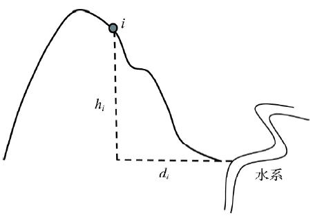
土壤流失距离指数反映的是由于距水系的距离差异而导致的相应土地利用类型对河流泥沙的贡献程度的差异[16]。在流域尺度,某种土地利用类型距水系的距离可以进一步分解为水平距离和垂直距离(图2),di是小流域中i点的土壤流失水平距离,hi是小流域中i点的土壤流失垂直距离。基于ArcGIS-Desktop中Spatial Analyst的Straight Line函数,提取距水系水平距离的空间分布图,进而获得点i的土壤流失水平距离。土壤流失垂直距离的提取相对复杂,具体可分为4步。① 将水系矢量数据转为栅格数据,栅格值设为1。② 基于ArcGIS平台中的Raster Calculator模块,将水系栅格与DEM数据相乘,获得具有高程值的水系图。③ 应用ArcGIS平台的Workstation中Grid Tools的Expand Zones函数,将水系的高程值向外拓展,得到覆盖整个小流域的水系高程面(即水系所在的曲面)。④ 将DEM数据与该水系高程面数据相减,即可得到土壤流失垂直距离分布图。基于获得的土壤流失水平距离和垂直距离进一步计算水平距离指数(D)和垂直距离指数(H)。
 显示原图|下载原图ZIP|生成PPT
图2土壤流失水平距离di和垂直距离hi
-->Fig. 2Schematic diagram of horizontal distance and vertical distance of soil loss
-->
D——土壤流失水平距离指数,土壤流失水平距离指数的计算公式为:
式中:Di为小流域/流域中某点土壤流失距离指数;Dmax是小流域/流域中土壤流失距离的最大值;di是小流域中某点的土壤流失距离,土壤流失距离是指小流域/流域中某点沿着泥沙运移路径距离水系的最小直线距离。
H——土壤流失垂直距离指数,土壤流失垂直距离指数的计算公式为:
式中:Hi是流域中某点的土壤流失垂直距离指数;Hmax是流域中土壤流失垂直距离的最大值;hi是流域中某点的土壤流失垂直距离。
S——坡度因子指数,坡度因子的计算公式为[21]:
将
式中:Si为流域中某点的坡度因子指数;θ为流域中i点的坡度;S'i为坡度因子;S'min和S'max分别为流域中坡度因子的最小值和最大值。
4 结果与分析
4.1 降雨和土地利用格局指数中各因子变化特征
4.1.1 降雨侵蚀力因子计算 采用针对黄土丘陵沟壑区修正的章文波降雨侵蚀力简易算法,计算2006-2012年陕北黄土丘陵沟壑区57个站点的降雨侵蚀力。将降雨侵蚀力进行插值后得到2006-2012年陕北黄土丘陵沟壑区降雨侵蚀力因子R的空间分布(图3)。总体来说,延河和大理河流域降雨侵蚀力较低,而清涧河和汾川河流域降雨侵蚀力较高。汾川河流域、清涧河流域上游降雨侵蚀力较高,下游次之;延河流域、大理河流域下游降雨侵蚀力较高,上游次之。研究区降雨侵蚀力存在两个高值区,分别是清涧河上游地区和汾川河上游地区;低值区分别位于大理河上游和延河流域上中游。统计2006-2012年陕北黄土丘陵沟壑区的降雨侵蚀力得到图4。从图4中可看出,2006-2012年,研究区降雨侵蚀力总体呈现上升趋势,其中2008年和2010年降雨量较小,因此2008年和2010年的降雨侵蚀力较低。 显示原图|下载原图ZIP|生成PPT
图32006-2012年陕北黄土丘陵沟壑区降雨侵蚀力R的空间分布
-->Fig. 3Spatial distribution of rainfall erosivity in hilly and gully area of the Loess Plateau from 2006 to 2012
-->
 显示原图|下载原图ZIP|生成PPT
图42006-2012年陕北黄土丘陵沟壑区降雨侵蚀力年际变化
-->Fig. 4Interannual variation of rainfall erosivity in hilly and gully area of the Loess Plateau from 2006 to 2012
-->
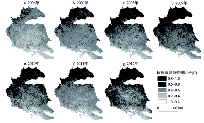
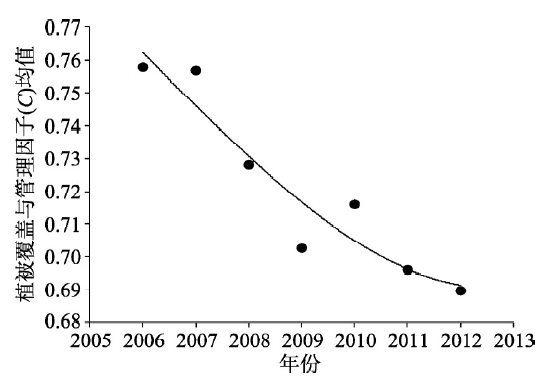
4.1.2 植被覆盖与管理因子计算 经计算得到2006-2012年的陕北黄土丘陵沟壑区C因子分布图(图5)。从图5中可以看出,陕北黄土丘陵沟壑区北部大理河流域的C因子值较高,南部汾川河流域C因子值较低。研究区由北至南,C因子值降低。统计流域内植被覆盖与管理因子C平均值的年际变化得到图6,从图6中可以看出2006-2012年,C因子均值总体上呈现下降趋势。研究区位于黄土高原,自1998年开始全面推行退耕还林(草)政策。2000年之后退耕还林(草)政策已经取得了明显的成效,植被覆盖明显增加,生态环境质量得到了显著提升。并且,随着时间的推移和对退耕还林(草)政策的持续贯彻执行,陕北黄土丘陵沟壑区的植被覆盖度不断升高[22]。C因子与植被覆盖度之间联系密切,根据C因子计算式(7)~(8),2006-2012年陕北黄土丘陵沟壑区C因子总体上呈现下降趋势。
 显示原图|下载原图ZIP|生成PPT
图52006-2012年陕北黄土丘陵沟壑区植被覆盖与管理因子C的空间分布
-->Fig. 5Spatial distribution of cover-management factor C in hilly and gully area of the Loess Plateau from 2006 to 2012
-->
 显示原图|下载原图ZIP|生成PPT
图62006-2012年陕北黄土丘陵沟壑区植被覆盖与管理因子C均值年际变化
-->Fig. 6Interannual variation of cover-management factor C in hilly and gully area of the Loess Plateau from 2006 to 2012
-->
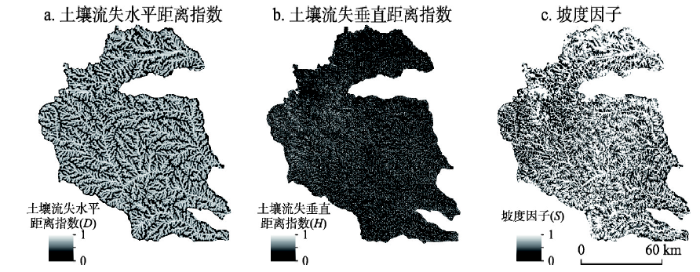
4.1.3 其他因子计算 基于数字高程图(DEM)提取研究区内水平面上各点距离水系的最小直线距离、距水系的垂直距离以及坡度信息,根据研究方法中的相关公式计算研究区土壤流失水平距离指数、土壤流失垂直距离指数、坡度因子指数。研究区的土壤流失水平距离指数、土壤流失垂直距离指数、坡度因子指数各项指数图如图7所示。
 显示原图|下载原图ZIP|生成PPT
图7陕北黄土丘陵沟壑区土壤流失水平距离指数、土壤流失垂直距离指数和坡度因子指数图
-->Fig. 7The horizontal distance index of soil loss, the vertical distance index of soil loss and the slope factor index in hilly and gully area of the Loess Plateau
-->
4.2 多流域降雨格局对土壤侵蚀的影响
根据降雨格局SLR指数的基本形式得到13个小流域2006-2012年的SLR指数,并计算13个小流域的SLR指数与输沙量数据的相关系数,然后将相关系数与流域面积进行相关分析(在0.05水平上显著相关),得到多流域降雨格局对土壤侵蚀的影响(图8)。从图8中可以看出,随流域面积的增加,陕北黄土丘陵沟壑区内降雨格局对土壤侵蚀的影响逐渐降低。流域面积越小,降雨格局对土壤侵蚀的贡献越大;流域面积越大,降雨格局对土壤侵蚀的贡献越小。 显示原图|下载原图ZIP|生成PPT
图8陕北黄土丘陵沟壑区不同面积流域上降雨格局对土壤侵蚀影响
-->Fig. 8Effect of rainfall pattern on soil erosion in different watersheds of hilly and gully area of the Loess Plateau
-->
4.3 多流域土地利用格局对土壤侵蚀的影响
根据土地利用格局SLC指数的基本形式计算得到13个小流域2006-2012年的SLC指数,分析13个小流域的SLC指数与输沙量数据的相关性,进一步将相关系数与流域面积进行相关分析(在0.05水平上显著相关),得到多流域土地利用格局对土壤侵蚀的影响(图9)。从图9中可以看出,随流域面积的增加,陕北黄土丘陵沟壑区内土地利用格局对土壤侵蚀的影响逐渐升高。流域面积越小,土地利用格局对土壤侵蚀的贡献越小;流域面积越大,土地利用格局对土壤侵蚀的贡献越大。 显示原图|下载原图ZIP|生成PPT
图9陕北黄土丘陵沟壑区不同面积流域上土地利用格局对土壤侵蚀影响
-->Fig. 9Effect of land use pattern on soil erosion in different watersheds of hilly and gully area of the Loess Plateau
-->
4.4 不同流域面积降雨和土地利用格局对土壤侵蚀影响的对比分析
比较13个小流域的降雨格局指数和输沙量的相关系数(SLR-输沙量)以及土地利用格局指数与输沙量的相关系数(SLC -输沙量)得到图10。从图10中可以看出,在曹坪、杏河、青阳岔、枣园、李家河、子长、临镇7个小流域中,降雨格局指数和输沙量的相关系数均比土地利用格局指数与输沙量的相关系数大,而在安塞、绥德、新市河、延安、延川、甘谷驿6个小流域中,土地利用格局指数与输沙量的相关系数比降雨格局指数和输沙量的相关系数大。图10中,横坐标小流域从左到右面积依次增大。据此可以推断,在流域面积较小时,降雨格局对土壤侵蚀的影响要大于土地利用格局对土壤侵蚀的影响,而在流域面积较大时,土地利用格局对土壤侵蚀的影响比降雨格局对土壤侵蚀的影响大。 显示原图|下载原图ZIP|生成PPT
图10陕北黄土丘陵沟壑区13个小流域降雨格局和土地利用格局对土壤侵蚀的影响比较
-->Fig. 10Comparison of the effect of rainfall pattern and land use pattern on soil erosion in thirteen watersheds of hilly and gully area of the Loess Plateau
-->
4.5 原因分析
土壤侵蚀的发生是降水、土地利用、地形、土壤等各种因素相互影响与制约的综合结果,影响因子繁多,作用过程复杂。在流域面积较小时,降雨格局对土壤侵蚀的影响要大于土地利用格局对土壤侵蚀的影响,而在流域面积较大时,土地利用格局对土壤侵蚀的影响凸显,成为影响土壤侵蚀的主要因子。在流域尺度,不同的土地利用方式通过影响下垫面的特性进而影响径流的产生。人类在追求自身生存与发展的同时,不断改变着陆地的表层环境。土地利用格局的变化是人类活动作用于陆地表层环境的一种重要方式和响应[24]。土地利用格局对土壤侵蚀影响的实质是人类活动对土壤侵蚀的影响。研究区自1998年开始推行退耕还林(草)政策,是陕北黄土丘陵沟壑区自1998年来最大规模的人类活动。退耕还林(草)工程使得研究区的植被覆盖度明显增加,并且在很大程度上改变了研究区的土地利用格局。有研究指出,陕北黄土丘陵沟壑区随着流域面积的增加,各土地利用类型中,草地的比例上升,林地和农田的比例下降,陡坡植被覆盖类型趋于单一化[25]。林地与草地和农地相比,具有较好的土壤蓄水能力和水土保持能力,且多数林地都具有林—灌—草或林—草等多层次结构,能够有效吸收和阻延地表径流,具有良好的水土保持能力。随着流域面积的增加,研究区的林地比例有所下降,陡坡植被覆盖类型趋于单一,这是在流域面积增大时土地利用格局对土壤侵蚀影响增加的主要原因。同时,这也表明在流域面积较大时,人类活动对土壤侵蚀的影响增大。
此外,流域面积较小时,流域内土壤侵蚀更多的是雨滴溅蚀、片流侵蚀、细沟侵蚀,细沟下切到心土和底土时逐步发育成浅沟;当流域面积增大时,径流在浅沟中汇集,使沟床下切,沟岸扩展,沟头前进,形成割裂地面的切沟。当侵蚀方式以溅蚀和片蚀为主时,侵蚀产沙量较小且稳定,降雨对土壤侵蚀的影响较大。当侵蚀方式以浅沟侵蚀为主时,侵蚀产沙量增加,降雨、土壤、土地利用都是影响土壤侵蚀的重要因子。当沟蚀(包括重力侵蚀)成为主要侵蚀方式时,侵蚀产沙量明显增加,侵蚀泥沙主要来自切沟壁崩塌和沟槽下切[26]。此时,松软的土壤性质和沟壑纵横的地形增大了发生重力侵蚀的可能性,土壤和地形对土壤侵蚀的影响增加。
5 结论与讨论
5.1 结论
本文基于土壤侵蚀评价指数,发展了降雨格局指数和土地利用格局指数,基于RUSLE模型中的降雨侵蚀力因子R和植被覆盖与管理因子C,综合考虑陕北黄土丘陵沟壑区特殊的地形地貌,结合距水系水平距离、垂直距离、坡度等地形因子,利用降雨和土地利用格局指数对比分析了多流域降雨和土地利用格局对土壤侵蚀的影响。(1)2006-2012年,研究区降雨侵蚀力因子R总体上呈现上升的趋势,植被覆盖与管理因子C呈现下降趋势。
(2)随流域面积的增加,研究区内降雨格局对土壤侵蚀的影响逐渐降低,土地利用格局对土壤侵蚀的影响逐渐增加。在流域面积较小时,降雨格局对土壤侵蚀的影响要大于土地利用格局对土壤侵蚀的影响,而在流域面积较大时,土地利用格局对土壤侵蚀的影响大于降雨格局对土壤侵蚀的影响。
(3)随着流域面积的增加,研究区的林地比例有所下降,陡坡植被覆盖类型趋于单一,这是在流域面积增大时土地利用格局对土壤侵蚀影响增加的主要原因。同时,流域面积较小时,降雨对土壤侵蚀的影响较大,但随着流域面积的增加,松软的土壤性质和沟壑纵横的地形增大了发生重力侵蚀的可能性,土壤和地形对土壤侵蚀的影响增大。
5.2 讨论
胡琳等的研究表明1971-2012年间陕西省降雨侵蚀力的空间分布呈由南向西北递减态势[27],这与本文的研究结果类似。本文研究结果表明,研究区北部的延河和大理河流域降雨侵蚀力较低,而南部清涧河和汾川河流域降雨侵蚀力较高。许多****研究了黄土高原地区的植被覆盖度空间分布格局及其时间变化特征,结果均表明黄土高原地区2006-2012年间年均植被覆盖度呈现上升趋势,整体来看黄土高原地区植被覆盖度东南部高、西北部低[28-29]。本文的研究也得到了类似的结论,植被覆盖与管理因子C与植被覆盖呈负相关,所以研究区的植被覆盖与管理因子C在2006-2012年间呈下降趋势,C因子在空间上的分布呈现南低北高的趋势。卫伟等的研究表明,不同的降雨格局和土地利用格局下,径流和侵蚀表现出明显的差异性,本文的研究进一步验证了此结论[8]。土壤侵蚀评价指数(SL指数)不仅包含土壤侵蚀因子的空间分布格局信息,并且能够反映不同尺度的土壤流失过程。但SL指数中涉及到的因子较多,计算过程繁琐。本文基于SL指数,剔除原指数中与土地利用格局无关的因子,只保留土壤流失水平距离指数、土壤流失垂直距离指数和坡度因子,提出了土地利用格局指数以反映土地利用格局对土壤侵蚀的影响。另外,本文根据土地利用格局指数的思路,提出了降雨格局指数。修正后的指数数据较易获取,计算过程相对简单,并且能够反映土地利用格局和降雨格局对土壤侵蚀的影响。
土壤侵蚀是降水、土地利用、土壤、地形、耕作管理方式等多种因素互相影响与制约的综合结果。本文重点分析了降水和土地利用两个因素的空间格局对土壤侵蚀的影响,但没有考虑降水和土地利用两个因子之间的空间相关性。因此,今后需要综合考虑降水、土地利用、土壤、地形、耕作管理方式等多种因子的空间分布格局,并分析不同因子之间的相关性,进一步揭示在流域面积不同的情况下各因子对土壤侵蚀的影响。
The authors have declared that no competing interests exist.
参考文献 原文顺序
文献年度倒序
文中引用次数倒序
被引期刊影响因子
| [1] | . This contribution to the immersed worlds wish to develop the avatar that will teach the students and other scientists how to develop measurements of soil erosion, surface runoff and wetting fronts by means of simulated rainfall experiments. Rainfall simulation is a well established and knows methodology to measure the soil erosion rates and soil hydrology under controlled conditions (Cerdà 1998a; Cerdà, 1998b; Cerdà and Jurgensen, 2011; Dunkerley, 2012; Iserloh et al., 2012; Iserloh et al., 2013; Ziadat and Taimeh, 2013; Butzen et al., 2014). However, is a method that requires a long training and expertise to avoid mismanagement and mistaken. To use and avatar can help in the teaching of the technique and the dissemination of the findings. This contribution will show to other avatars how to develop an experiment with simulated rainfall and will help to take the right decision in the design of the experiments. Following the main parts of the experiments and measurements the Wildgeographer avatar must develop: 1. Determine the objectives and decide which rainfall intensity and distribution, and which plot size to be used. Choose between a laboratory or a field rainfall simulation. 2. Design of the rainfall simulator to achieve the objectives: type of rainfall simulator (sprayer or drop former) and calibrate. 3. The experiments are carried out. 4. The results are show. Acknowledgements To the "Ministerio de Economía and Competitividad" of Spanish Government for finance the POSTFIRE project (CGL2013- 47862-C2-1-R). The research projects GL2008-02879/BTE, LEDDRA 243857 and PREVENTING AND REMEDIATING DEGRADATION OF SOILS IN EUROPE THROUGH LAND CARE (RECARE)FP7-ENV-2013- supported this research. References Butzen, V., Seeger, M., Wirtz, S., Huemann, M., Mueller, C., Casper, M., Ries, J. B. 2014. Quantification of Hortonian overland flow generation and soil erosion in a Central European low mountain range using rainfall experiments. Catena, 113, 202-212. Cerdà, A. 1998a. Effect of climate on surface flow along a climatological gradient in Israel. A field rainfall simulation approach. Journal of Arid Environments, 38, 145-159. Cerdà, A. 1998b. The influence of aspect and vegetation on seasonal changes in erosion under rainfall simulation on a clay soil in Spain. Canadian Journal of Soil Science, 78, 321-330. Cerdà, A., Jurgensen, M. F. 2011. Ant mounds as a source of sediment on citrus orchard plantations in eastern Spain. A three-scale rainfall simulation approach. Catena, 85(3), 231-236. Dunkerley, D. 2012. Effects of rainfall intensity fluctuations on infiltration and runoff: rainfall simulation on dryland soils, Fowlers Gap, Australia. Hydrological Processes, 26(15), 2211-2224. Iserloh, T., Ries, J.B., Arnaez, J., Boix Fayos, C., Butzen, V., Cerdà, A., Echeverría, M.T., Fernández-Gálvez, J., Fister, W., Gei08ler, C., Gómez, J.A., Gómez-Macpherson, H., Kuhn, N.J., Lázaro, R., León, F.J., Martínez-Mena, M., Martínez-Murillo, J.F., Marzen, M., Mingorance, M.D., Ortigosa, L., Peters, P., Regüés, D., Ruiz-Sinoga, J.D., Scholten, T., Seeger, M., Solé-Benet, A., Wengel, R., Wirtz, S. 2013. European small portable rainfall simulators: a comparison of rainfall characteristics. Catena, 110, 100-112. Doi: 10.1016/j.catena.2013.05.013 Iserloh, T., Ries, J.B., Cerdà, A., Echeverría, M.T., Fister, W., Gei08ler, C., Kuhn, N.J., León, F.J., Peters, P., Schindewolf, M., Schmidt, J., Scholten, T., Seeger, M. (2012): Comparative measurements with seven rainfall simulators on uniform bare fallow land. Zeitschrift für Geomorphologie, 57, 193-201. DOI: 10.1127/0372- 8854/2012/S-00118. Ziadat, F. M., Taimeh, A. Y. 2013. Effect of rainfall intensity, slope and land use and antecedent soil moisture on soil erosion in an arid environment. Land Degradation & Development, 24: 582- 590. DOI 10.1002/ldr.2239 |
| [2] | . Abstract NB = The full book (i.e. IAEA-TECDOC-1741) is available for free, please see: http://www-pub.iaea.org/books/IAEABooks/10501/Guidelines-for-Using-Fallout-Radionuclides-to-Assess-Erosion-and-Effectiveness-of-Soil-Conservation-Strategies- |
| [3] | . Soil erosion take place in degraded ecosystem where the lack of vegetation, drought, erodible parent material and deforestation take place (Borelli et al., 2013; Haregeweyn et al., 2013; Zhao et al., 2013). Agriculture management developed new landscapes (Ore and Bruins, 2012) and use to trigger non-sustainable soil erosion rates (Zema et al., 2012). High erosion rates were measured in agriculture land (Cerdà et al., 2009), but it is also possible to develop managements that will control the soil and water losses, such as organic amendments (Marqués et al., 2005), plant cover (Marqués et al., 2007) and geotextiles (Giménez Morera et al., 2010). The most successful management to restore the structural stability and the biological activity of the agriculture soil has been the organic mulches (García Orenes et al; 2009; 2010; 2012). The straw mulch is also very successful on bare fire affected soil (Robichaud et al., 2013a; 2013b), which also contributes to a more stable soil moisture content (García-Moreno et al., 2013). The objective of this research is to determine the impact of two mulches: wheat straw and chipped branches, on the soil erosion rates in a rainfed vineyard in Eastern Spain. The research site is located in the Les Alcusses Valley within the Moixent municipality. The Mean annual temperature is 13 02C, and the mean annual rainfall 455 mm. Soil are sandy loam, and are developed at the foot-slope of a Cretaceous limestone range, the Serra Grossa range. The soils use to be ploughed and the features of soil erosion are found after each thunderstorm. Rills are removed by ploughing. Thirty rainfall simulation experiments were carried out in summer 2011 during the summer drought period. The simulated rainfall lasted during 1 hour at a 45 mmh-1 intensity on 1 m2 plots (Cerdà and Doerr, 2010; Cerdà and Jurgensen 2011). Ten experiments were carried out on the control plots (ploughed), 10 on straw mulch covered plots, and 10 on chipped branches covered soil. The results show that the soil erosion is reduced by 10 on straw mulch covered soils and by 4 on chipped branches covered soil. Acknowledgements The research projects GL2008-02879/BTE, LEDDRA 243857 and RECARE supported this research. References Borrelli, P., M01rker, M., Schütt, B. 2013. Modelling post-tree-haversting soil erosion and sediment deposition potential in the Turano River Basin (Italian Central Apennine). Land Degradation & Development, DOI 10.1002/ldr.2214 Cerdà, A., Flanagan, D.C., le Bissonnais, Y., Boardman, J. 2009. Soil erosion and agriculture Soil and Tillage Research 106, 107-108. DOI: 10.1016/j.still.2009.1 Cerdà, A., Morera, A.G., Bodí, M.B. 2009. Soil and water losses from new citrus orchards growing on sloped soils in the western Mediterranean basin. Earth Surface Processes and Landforms 34, 1822-1830. García-Moreno, J., Gordillo-Rivero, 09.J., Zavala, L.M., Jordán, A., Pereira, P. 2013. Mulch application in fruit orchards increases the persistence of soil water repellency during a 15-years period. Soil and Tillage Research 130, 62-68. García-Orenes, F., Cerdà, A., Mataix-Solera, J., Guerrero, C., Bodí, M.B., Arcenegui, V., Zornoza, R. & Sempere, J.G. 2009. Effects of agricultural management on surface soil properties and soil-water losses in eastern Spain. Soil and Tillage Research 106, 117-123. 10.1016/j.still.2009.06.002 García-Orenes, F., Guerrero, C., Roldán, A.,Mataix-Solera, J., Cerdà, A., Campoy, M., Zornoza, R., Bárcenas, G., Caravaca. F. 2010. Soil microbial biomass and activity under different agricultural management systems in a semiarid Mediterranean agroecosystem. Soil and Tillage Research 109, 110-115. 10.1016/j.still.2010.05.005. García-Orenes, F., Roldán, A., Mataix-Solera, J., Cerdà, A., Campoy, M., Arcenegui, V., Caravaca, F. 2012. Soil structural stability and erosion rates influenced by agricultural management practices in a semi-arid Mediterranean agro-ecosystem. Soil Use and Management 28, 571-579. DOI: 10.1111/j.1475-2743.2012.00451.x Giménez Morera, A., Ruiz Sinoga, J.D. y Cerdà, A. 2010. The impact of cotton geotextiles on soil and water losses in Mediterranean rainfed agricultural land. Land Degradation and Development , 210- 217. DOI: 10.1002/ldr.971. Haregeweyn, N., Poesen, J., Verstraeten, G., Govers, G., de Vente, J., Nyssen, J., Deckers, J., Moeyersons, J. 2013. Assessing the performance of a Spatially distributed soil erosion and sediment delivery model (WATEM/SEDEM) in Northern Ethiopia. Land Degradation & Development 24, 188-204. DOI 10.1002/ldr.1121 Marqués M.J., Jiménez, L., Pérez-Rodríguez, R., García-Ormaechea, S., Bienes, R. 2005. Reducing water erosion by combined use of organic amendment and shrub revegetation. Land Degradation Development, 16, 339-350. Marqués, M.J., Bienes, R., Jiménez, L., Pérez-Rodríguez, R.. 2007. Effect of vegetal cover on runoff and soil erosion under light intensity events. Rainfall simulation over USLE plots. Science of the Total Environment, 378, 161-165. Ore, G., Bruins, H. J. 2012. Design features of ancient agriculture terrace walls in the Negev Desert: human-made geodiversity. Land Degradation & Development, 23: 409- 418. DOI 10.1002/ldr.2152 Robichaud, P.R., Lewis, S.A., Wagenbrenner, J.W., Ashmun, L.E., Brown, R.E. 2013a. Post-fire mulching for runoff and erosion mitigation. Part I: Effectiveness at reducing hillslope erosion rates. Catena 105, 75-92. Robichaud, P.R., Wagenbrenner, J.W., Lewis, S.A., Ashmun, L.E., Brown, R.E., Wohlgemuth, P.M. 2013b. Post-fire mulching for runoff and erosion mitigation. Part II: Effectiveness in reducing runoff and sediment yields from small catchments. Catena 105, 93-111. Wang, L., Tang, L., Wang, X., Chen, F. 2010. Effects of alley crop planting on soil and nutrient losses in the citrus orchards of the Three Gorges Region. Soil and Tillage Research 110, 243-250. Wu J., Li Q., Yan L. 1997. Effect of intercropping on soil erosion in young citrus plantation - a simulation study. Chinese Journal of Applied Ecology 8, 143-146. Zema, D. A., Bingner, R. L., Denisi, P., Govers, G., Licciardello, F., Zimbone, S. M. 2012. Evaluation of runoff, peak flow and sediment yield for events simulated by the AnnAGNPS model in a belgian agricultural watershed. Land Degradation & Development, 23: 205- 215. DOI 10.1002/ldr.1068 Zhao, G., Mu, X., Wen, Z., Wang, F., Gao, P. 2013. Soil erosion, conservation, and eco-environment changes in the Loess Plateau of China. Land Degradation & Development, 24, 499- 510. DOI 10.1002/ldr.2246SP |
| [4] | . Agricultural activities have drastically increased soil erosion rates and it is therefore likely to have important effects on the Earth's Critical Zone. In this paper we first investigate to what extent agricultural soil erosion can be quantified. We then combine this information with our current understanding of Critical Zone processes to assess the impact of agricultural soil erosion on soil functioning (biogeochemical cycling, hydrology, crop productivity) and to identify areas where additional research is needed to complete our understanding of how agricultural soil erosion affects the Earth's Critical Zone at different spatial and temporal scales. |
| [5] | , Soil water erosion on cultivated lands is a severe threat to soil resources in the world (Leh et al., 2013; Zhao et al., 2013). In particular, Mediterranean areas deserve a particular attention because of their edaphic, topographic and climatic conditions. Among the cultivated lands, concerns have arisen about vineyards because, aside representing one of the most important crop in terms of income and employment, they also have proven to be the form of agricultural land that causes one of the highest soil losses (Tropeano et al., 1984; Leonard and Andrieux, 1998; Ferrero et al., 2005; Cerd et al., 2007; Blavet et al., 2009; Casal et al., 2009; Novara et al., 2011; Mart nez Casasnovas et al., 2013; Ruiz Colmenero et al., 2013; Tarolli et al., 2014). Although the topic of soil water erosion on vineyards has been studied, it still raises uncertainties. These are due to the i) high complexity of processes involved, ii) different methodologies used to analyze them and iii) analyses carried out at different spatial and temporal scales. At this regard, this work aims to evaluate the impact of factors controlling erosion such as rainfall characteristics, topography, soil properties and soil and water conservation techniques. Data derived from experimental plots have been reviewed. At first, what emerges is the difficulty of comparing erosion rates obtained with different methodologies and at different spatial scales. Secondly, all the factors demonstrate to have a strong impact on soil erosion but a 'general rule' upon which to consider one factor always predominant over the others does not come out. Therefore, this work supports the importance of monitoring soil water erosion by field measurements to better understand the relationship between the factors. Variables like rainfall characteristics, topography and soil properties are much more difficult to modify than the soil and water management techniques. Hence, future researches are needed to both recommend the best soil and water management techniques to the farmers and implement soil erosion mitigation policies at appropriate spatial scales. Acknowledgements The RECARE project is funded by the European Commission FP7 program, ENV.2013.6.2-4 "Sustainable land care in Europe". References Blavet, D., De Noni, G., Le Bissonnais, Y., Leonard, M., Maillo, L., Laurent, J.Y., Asseline, J., Leprun, J. C., Arshad, M. A., Roose, E.: Effect of land use and management on the early stages of soil water erosion in French Mediterranean vineyards, Soil & Tillage Research, 106, 124-136, 2009. Brenot, J., Quiquerez, A., Petit, C., Garcia, J.-P., Davy, P.: Soil erosion rates in Burgundian vineyards, Bolletino della Societ Geologica Italiana, Volume Speciale 6, 169-174, 2006. Casal , J., Gimnez, R., De Santisteban, L., Alvarez-Mozos, J., Mena, J., Del Valle de Lersundi, J.: Determination of long-term erosion rates in vineyards of Navarre (Spain) using botanical benchmarks, Catena, 78, 12-19, doi:10.1016/ j.catena.2009.02.015, 2009. Cerd , A., Doerr, S. H.: Soil wettability, runoff and erodibility of major dry-Mediterranean land use types on calcareous soils, Hydrological Processes, 21, 2325-2336, doi: 10.1016/j.catena.2008.03.010, 2007. Ferrero, A., Usowicz, B., Lipiec, J.: Effects of tractor traffic on spatial variability of soil strength and water content in grass covered and cultivated sloping vineyard, Soil & Tillage Research, 84, 127-138, 2005. Leh, M., Bajwa, S., Chaubey, I.: Impact of land use change on erosion risk: and integrated remote sensing geographic information system and modeling methodology, Land Degradation & Development, 24, 409- 421, doi 10.1002/ldr.1137, 2013. Leonard, J., Andrieux, P.: Infiltration characteristics of soils in Mediterranean vineyards in southern France, Catena, 32, 209-223, 1998. Martinez-Casasnovas, J. A., Ramos, M. C., Benites, G.: Soil and water assessment tool soil loss simulation at the sub-basin scale in the Alt Pened s-Anoia vineyard region (NE Spain) in the 2000s, Land Degradation & Development, doi: 10.1002/ldr.2240, 2013. Novara, A., Gristina, L., Saladino, S. S., Santoro, A., Cerd , A.: Soil erosion assessment on tillage and alternative soil managements in a Sicilian vineyard, Soil & Tillage Research, 117, 140-147, 2011. Ruiz-Colmenero, M., Bienes, R., Eldridge, D. J., Marques, M. J.: Vegetation cover reduces erosion and enhances soil organic carbon in a vineyard in the central Spain, Catena, 104, 153-160, doi:10.1016/j.catena.2012.11.007, 2013. Tarolli, P., Sofia, G., Calligaro, S., Prosdocimi, M., Preti, F., Dalla Fontana, G.: Vineyards in terraced landscapes: new opportunities from lidar data, Land Degradation & Development, doi:10.1002/ldr.2311, 2014. Tropeano, D.: Rate of soil erosion processes on vineyards in central Piedmont (NW Italy), Earth Surf. Process. Landf., 9, 253- 266, 1984. Zhao, G., Mu, X., Wen, Z., Wang, F., Gao, P.: Soil erosion, conservation, and Eco-environment changes in the Loess Plateau of China, Land Degradation & Development, 24, 499- 510, doi 10.1002/ldr.2246, 2013. |
| [6] | . Understanding soil erosion processes in the Ecuadorian Andes with a tropical wet-dry climate and a variable topography, is fundamental for research on agriculture sustainable, environmental management, as well as for a stable water supply for the local populations. This work proposes method to estimate soil erosion risk in the semiarid Catamayo basin with limited data. The results show that the rainfall distribution and the erosivity along with the rugged topography, followed by the land cover (C-factor), are the most important factors to estimate soil erosion risk. The soil erodibility is the most important factor in the dry season for agricultural areas and where the ground cover is sparse. Soil erosion risk is higher in the centre and southwest than in the northeast of Catamayo basin. In protected areas with evergreen vegetation, the soil erosion risk is very low, even with steep slopes and high annual rainfall amounts. The methodology developed allows understanding of the soil erosion processes and the factors that lead to the spatio-temporal variability of soil erosion risk, and as a consequence improves the potential to achieve sustainability of this ecosystem through proposed conservation measures. |
| [7] | . Global climate and land use changes could strongly affect soil erosion and the capability of soils to sustain agriculture and in turn impact regional or global food security. The objective of our study was to develop a method to assess soil sustainability to erosion under changes in land use and climate. The method was applied in a typical mixed Mediterranean landscape in a wine-growing watershed (75km 2 ) within the Languedoc region (La Peyne, France) for two periods: a first period with the current climate and land use and a second period with the climate and land use scenarios at the end of the twenty-first century. The Intergovernmental Panel on Climate Change A1B future rainfall scenarios from the M茅t茅o France General circulation model was coupled with four contrasting land use change scenarios that were designed using a spatially-explicit land use change model. Mean annual erosion rate was estimated with an expert-based soil erosion model. Soil life expectancy was assessed using soil depth. Soil erosion rate and soil life expectancy were combined into a sustainability index. The median simulated soil erosion rate for the current period was 3.5t/ha/year and the soil life expectancy was 273 years, showing a low sustainability of soils. For the future period with the same land use distribution, the median simulated soil erosion rate was 4.2t/ha/year and the soil life expectancy was 249 years. The results show that soil erosion rate and soil life expectancy are more sensitive to changes in land use than to changes in precipitation. Among the scenarios tested, institution of a mandatory grass cover in vineyards seems to be an efficient means of significantly improving soil sustainability, both in terms of decreased soil erosion rates and increased soil life expectancies. |
| [8] | . 黄土丘陵区; 降雨格局; 土地利用; 水土流失 . 黄土丘陵区; 降雨格局; 土地利用; 水土流失 |
| [9] | . 全球变化引起了一系列环境效应,土壤侵蚀是全球变化最为敏感环境效应之一。选择生态极其脆弱区小江流域作为研究对象,通过遥感影像和雨量站点获取3期土地利用和降雨变化信息,结合区域基础地理信息数据,利用通用土壤流失方程(USLE模型)对该区域土壤侵蚀对土地利用和降雨变化的响应进行了分析。研究表明:(1)降雨量在1981~1990年为降雨量较小年份,1991~2000年为降雨量较大时间段,2001~2005年降雨量开始急剧减少;(2)1987、1995和2005年的平均侵蚀量分别为:70.58、80.08和79.81t/(hm2.a),中度侵蚀以上面积分别占总面积的29.92%、33.83%和33.18%,其中极强度侵蚀分别占9.15%、12.81%和12.63%;(3)在分布特征上,强度侵蚀和极强度侵蚀主要分布在小江流域的中下游地段。极强度侵蚀主要分布在中海拔区域(1 600~2 800m),所占的比例呈持续下降的趋势,但在高海拔区域,极强度侵蚀呈增加趋势;同时,极强度侵蚀集中分布在高坡度段(〉35°)上,占其面积的85%以上,且呈持续增加趋势,在中坡度段(15°~35°)上,极强度侵蚀呈现明显的减少趋势。USLE模型可以较好的反映出全球变化条件下土壤侵蚀效应,为合理开发土地资源和人类经济活动提供科学依据。 . 全球变化引起了一系列环境效应,土壤侵蚀是全球变化最为敏感环境效应之一。选择生态极其脆弱区小江流域作为研究对象,通过遥感影像和雨量站点获取3期土地利用和降雨变化信息,结合区域基础地理信息数据,利用通用土壤流失方程(USLE模型)对该区域土壤侵蚀对土地利用和降雨变化的响应进行了分析。研究表明:(1)降雨量在1981~1990年为降雨量较小年份,1991~2000年为降雨量较大时间段,2001~2005年降雨量开始急剧减少;(2)1987、1995和2005年的平均侵蚀量分别为:70.58、80.08和79.81t/(hm2.a),中度侵蚀以上面积分别占总面积的29.92%、33.83%和33.18%,其中极强度侵蚀分别占9.15%、12.81%和12.63%;(3)在分布特征上,强度侵蚀和极强度侵蚀主要分布在小江流域的中下游地段。极强度侵蚀主要分布在中海拔区域(1 600~2 800m),所占的比例呈持续下降的趋势,但在高海拔区域,极强度侵蚀呈增加趋势;同时,极强度侵蚀集中分布在高坡度段(〉35°)上,占其面积的85%以上,且呈持续增加趋势,在中坡度段(15°~35°)上,极强度侵蚀呈现明显的减少趋势。USLE模型可以较好的反映出全球变化条件下土壤侵蚀效应,为合理开发土地资源和人类经济活动提供科学依据。 |
| [10] | . Sub-Saharan Africa suffers from land degradation, depletion of natural resources and rural poverty. In the Lake Victoria Basin, where large parts of the population are small scale farmers, people are facing such issues coupled with altered climatic conditions. The focus area of this study is the Mara region in northern Tanzania, situated on the eastern lakeshore. Mara has experienced a doubling of its population during the past four decades and is subsequently suffering from land scarcity, deforestation, erosion, lake eutrophication, soil fertility decline etc. The main objective is to assess land cover change in Mara between 1986 and 2013, and to estimate soil erosion as an effect of land cover change by using the Revised Universal Soil Loss Equation (RUSLE). Supervised classification was done using the maximum likelihood method on Landsat TM and ETM+ images from 1986, 1999 and 2013 to generate thematic land cover maps. To isolate the effect of land cover change on erosion, all other factors affecting soil loss were kept constant in the modelling process. Fieldwork was carried out in order to gather ground truth data and to obtain an overview of the land cover dynamics as well as the living situation of the rural population. The results show an increase in the extent of agriculture, mainly at the expense of woodlands, shrublands and grasslands. The RUSLE calculations suggest that, if rainfall is fixed at the 1950-2000 mean, the annual average soil loss increases over the study period. The erosion changes can be attributed to the ongoing cropland expansion and the woodland degradation. A continuously growing population accompanied by higher demand for agricultural land and fuel wood will likely exacerbate deforestation and erosion in the future, especially as the climate is getting drier. Unless precautionary measures are taken the study area is likely to experience extensive future land degradation and poverty increase. |
| [11] | . |
| [12] | . Recent research has shown that wind can have a significant influence on velocity, impact angle and kinetic energy of raindrops, and subsequently increases soil erosion. The aims of this study were to 1) quantify the influence of wind on water erosion, 2) specifically observe the difference in processes between windless rain (WLR) and wind-driven rain (WDR) simulations and 3) test the device?s and test sequence?s practicability.The Portable Wind and Rainfall Simulator (PWRS), recently developed at Trier University for plot-scale in situ assessment of differences in soil erosion with and without the influence of wind on raindrops, was used. To facilitate extraction of the influences of WDR on soil erosion, to avoid systematic errors, and to reduce variability between test plots, a defined order of four consecutive test runs was established: 0) wind simulation, 1) WLR simulation on dry soil, 2) WLR simulation on moist soil, 3) WDR simulation. The tests were conducted on homogenous sandy substrate deposited on an area of 15.2 m 60 m with uniform and smooth surface and low inclination (1 ) in the Willem Genet Tunnel of Wageningen University. The results show an increase of eroded sediment ranging from 113% up to 1108% for WDR simulations in comparison to WLR simulations. The increase in runoff was considerably lower (15% to 71%), resulting in an increase of sediment concentration between 56% and 894%. The results indicate an immense impact of WDR on soil erosion of sandy cohesionless substrate. The experimental setting and measurement proved reliable and reproducible and enables a clear process observation and quantification in the field. |
| [13] | . Rain splash soil erosion in the presence of rock fragments and different initial conditions was tested in laboratory flume experiments under controlled conditions. The aim of the experiments was to ascertain whether cumulative soil erosion is proportional to the area of soil exposed to raindrop detachment under the condition of constant and uniform precipitation. The surface area exposed to rain splash erosion was adjusted by placing rock fragments onto the surface of identically prepared soil in laboratory flumes. The laboratory results showed that the eroded cumulative mass depended on the cumulative runoff, and that soil erosion was proportional to the soil surface area exposed to raindrops, in situations where an initially dry, plowed and smoothed soil surface was ensured. The results showed that this relationship was controlled to a smaller extent by the soil's initial moisture content, bulk density and soil surface characteristics. When the initial conditions were more complex, soil erosion was proportional to the area exposed only at steady state. Then, sediment concentrations during the first part of the erosion event were instead more sensitive to the initial state of the soil surface, whereas at steady state it was observed that the concentrations of eroded sediments were controlled mainly by the effective rainfall and area exposed to raindrops. Previously published field data on rain splash soil erosion were analyzed to ascertain whether the same behavior was evident under field conditions. For this case it was found that rain splash erosion is in general not proportional to the area exposed. In contrast to the controlled laboratory experiments, the field experiments were characterized by non-uniform initial surface roughness, surface soil aging and heterogeneous rock fragment size and spatial distribution. However, the presented laboratory results showed clearly that, for soils with negligible surface roughness, erosion depends on (i) the area of soil exposed to rainfall and (ii) the cumulative runoff, and that it is only slightly dependent on other soil variables. |
| [14] | . There are strong ties between land cover patterns and soil erosion and sediment yield in watersheds. The spatial configuration of land cover has recently become an important aspect of the study of geomorphological processes related to erosion within watersheds. Many studies have used multivariate regression techniques to explore the response of soil erosion and sediment yield to land cover patt... |
| [15] | . The scale effect implies that plot measurements may lead to an underestimation of the effectiveness of conservation tillage in reducing runoff and erosion at the field or catchment scale. We tested experimentally the hypothesis that this scale-dependency can (partly) be explained by the occurrence of runoff transmission losses along the hillslope. In a 2.3 m long soil tray, filled with a silty loam soil, a seedbed was simulated and covered with different amounts of straw and maize residues. Our data showed that transmission losses can indeed be important and that they depend on cover percentage, discharge, time of discharge application and residue type. A simple model exercise shows that, under realistic assumptions, the effect of transmission losses on runoff and erosion on arable land may be highly significant. At present, most erosion models explicitly or implicitly assume a linear increase of runoff with slope length: taking into account transmission losses may contribute to a better estimation of runoff and soil losses. Since no interaction effect between cover percentage and inflow rate was found, the relative difference in runoff and soil loss between bare and residue-covered surfaces did not change with scale. Thus, other factors than those observed are responsible for the observed increasing differences between conservation and conventional tillage with increasing scale. |
| [16] | . 针对不同尺度开展土地利用与土壤侵蚀的综合研究是自然地理学研究的前沿领域和热点问题。多尺度土壤侵蚀评价指数作为新近提出的土壤侵蚀模型,在跨尺度土地利用与土壤侵蚀的研究中具有良好应用前景。本文基于多尺度土壤侵蚀评价指数计算公式及其因子内涵,应用尺度转换的思想,阐述了降雨侵蚀力、土壤可蚀性、作物覆盖与管理因子、地形因子等不同评价因子在坡面、小流域、流域不同尺度上的计算方法与GIS实现技术,以期服务于多尺度土地利用与土壤侵蚀研究的深入和多尺度土壤侵蚀评价指数的发展。 . 针对不同尺度开展土地利用与土壤侵蚀的综合研究是自然地理学研究的前沿领域和热点问题。多尺度土壤侵蚀评价指数作为新近提出的土壤侵蚀模型,在跨尺度土地利用与土壤侵蚀的研究中具有良好应用前景。本文基于多尺度土壤侵蚀评价指数计算公式及其因子内涵,应用尺度转换的思想,阐述了降雨侵蚀力、土壤可蚀性、作物覆盖与管理因子、地形因子等不同评价因子在坡面、小流域、流域不同尺度上的计算方法与GIS实现技术,以期服务于多尺度土地利用与土壤侵蚀研究的深入和多尺度土壤侵蚀评价指数的发展。 |
| [17] | . 针对不同尺度研究土地利用与土壤侵蚀的关系是自然地理学研究的前 沿领域和热点问题.基于景观生态学的"尺度-格局-过程"原理,在考虑土地利用、地形、土壤、降雨等影响因素的基础上,应用尺度转换的方法,构建了不同尺 度土壤侵蚀评价指数,提出了多尺度土壤侵蚀评价指数的研究思路与方法.多尺度土壤侵蚀评价指数适用于土地利用与土壤侵蚀的关系评价和多尺度土壤侵蚀评价研 究,为区域土地利用格局的优化设计和多尺度综合研究提供了新的方法. . 针对不同尺度研究土地利用与土壤侵蚀的关系是自然地理学研究的前 沿领域和热点问题.基于景观生态学的"尺度-格局-过程"原理,在考虑土地利用、地形、土壤、降雨等影响因素的基础上,应用尺度转换的方法,构建了不同尺 度土壤侵蚀评价指数,提出了多尺度土壤侵蚀评价指数的研究思路与方法.多尺度土壤侵蚀评价指数适用于土地利用与土壤侵蚀的关系评价和多尺度土壤侵蚀评价研 究,为区域土地利用格局的优化设计和多尺度综合研究提供了新的方法. |
| [18] | . ABSTRACT Land use and land cover are most important in quantifying soil erosion. Based on the C-factor of the popular soil erosion model, Revised Universal Soil Loss Equation (RUSLE) and a scale-pattern-process theory in landscape ecology, we proposed a multi-scale soil loss evaluation index (SL) to evaluate the effects of land use patterns on soil erosion. We examined the advantages and shortcomings of SL for small watershed (SLsw) by comparing to the C-factor used in RUSLE. We used the Yanhe watershed located on China's Loess Plateau as a case study to demonstrate the utilities of SLsw. The SLsw calculation involves the delineations of the drainage network and sub-watershed boundaries, the calculations of soil loss horizontal distance index, the soil loss vertical distance index, slope steepness, rainfall-runoff erosivity, soil erodibility, and cover and management practice. We used several extensions within the geographic information system (GIS), and AVSWAT2000 hydrological model to derive all the required GIS layers. We compared the SLsw with the C-factor to identify spatial patterns to understand the causes for the differences. The SLsw values for the Yanhe watershed are in the range of 0.15 to 0.45, and there are 593 sub-watersheds with SLsw values that are lower than the C-factor values (LOW) and 227 sub-watersheds with SLsw values higher than the C-factor values (HIGH). The HIGH area have greater rainfall-runoff erosivity than LOW area for all land use types. The cultivated land is located on the steeper slope or is closer to the drainage network in the horizontal direction in HIGH area in comparison to LOW area. The results imply that SLsw can be used to identify the effect of land use distribution on soil loss, whereas the C-factor has less power to do it. Both HIGH and LOW areas have similar soil erodibility values for all land use types. The average vertical distances of forest land and sparse forest land to the drainage network are shorter in LOW area than that in HIGH area. Other land use types have shorter average vertical distances in HIGH area than that LOW area. SLsw has advantages over C-factor in its ability to specify the subwatersheds that require the land use patterns optimization by adjusting the locations of land uses to minimize soil loss. |
| [19] | [D]. [D]. |
| [20] | . 依据实地调查资料,建立了典型小流域地理数据库,应用径流小区观测结果,确定了定量计算通用土壤流失方程因子指标方法,在地理信息系统IDRISI支持下,根据USLE土壤侵蚀预测模型对数据库实施运算操作,预测了小流域土壤侵蚀量。结果表明,占流域面积67%的区域土壤侵蚀微弱或轻度,这一区域对流域土壤侵蚀量的贡献率仅为3%,而流域80%的泥沙来自于占流域面积仅20%的极强度和剧烈侵蚀区域。 . 依据实地调查资料,建立了典型小流域地理数据库,应用径流小区观测结果,确定了定量计算通用土壤流失方程因子指标方法,在地理信息系统IDRISI支持下,根据USLE土壤侵蚀预测模型对数据库实施运算操作,预测了小流域土壤侵蚀量。结果表明,占流域面积67%的区域土壤侵蚀微弱或轻度,这一区域对流域土壤侵蚀量的贡献率仅为3%,而流域80%的泥沙来自于占流域面积仅20%的极强度和剧烈侵蚀区域。 |
| [21] | . |
| [22] | . 黄土高原是我国生态环境最为脆弱的地区之一。探讨黄土高原地区植被覆盖动态变化对于区域植被恢复和生态系统重建具有积极意义。利用空间数据分析软件GeoDa和ArcGIS地统计分析模块,采用1998、2003、2008和2012年8月21日的SPOT-VGT NDVI数据代表黄土高原地区相应年份植被覆盖最大的时期,对黄土高原植被覆盖随时间的演变特征进行分析。结果表明,1998—2012年,黄土高原植被覆盖经历了先降低后增加的过程,且1998、2003、2008和2012年的归一化植被指数(NDVI)数值均有明显的空间自相关关系,NDVI值冷点区的位置和范围均较为稳定,热点区变化较大,主要分布在陕西和山西境内。 . 黄土高原是我国生态环境最为脆弱的地区之一。探讨黄土高原地区植被覆盖动态变化对于区域植被恢复和生态系统重建具有积极意义。利用空间数据分析软件GeoDa和ArcGIS地统计分析模块,采用1998、2003、2008和2012年8月21日的SPOT-VGT NDVI数据代表黄土高原地区相应年份植被覆盖最大的时期,对黄土高原植被覆盖随时间的演变特征进行分析。结果表明,1998—2012年,黄土高原植被覆盖经历了先降低后增加的过程,且1998、2003、2008和2012年的归一化植被指数(NDVI)数值均有明显的空间自相关关系,NDVI值冷点区的位置和范围均较为稳定,热点区变化较大,主要分布在陕西和山西境内。 |
| [23] | . ABSTRACT Land-levelling measures are widely used in the Souss valley, South Morocco, for the implementation of land use change. However, their impact on soil erosion in this region is unclear. This paper presents the approach of combining punctual process analysis through experimental rainfall simulation and gully mapping as well as volume quantification analysing on a local scale using unmanned aerial vehicle (UAV) remote sensing data. Thus, the influence of the impacts of land levelling in the catchment area on the linear soil erosion by gullies can be elucidated. Soil surface characteristics, modified by land levelling, lead to higher runoff generation and sediment production. Mean runoff coefficients from 54% to 58% are found in levelled study sites, and 38% to 47% are found in undisturbed areas. Mean sediment loads reach 48.6 g m61 2 to 81 g m61 2 under the influence of levelling, but only 9.3 g m61 2 to 23.7 g m61 2 without it. Quantification of soil erosion by UAV data showed that a gully in a levelled study site eroded about 720 m3 of soil within only one rain period. The surface of the catchment area was lowered 0.054 m on average due to land levelling, whereas in study sites without land levelling, the monitoring did not show significant differences of shape and extent of the gullies at two different points in time. The strong influence of land levelling can be documented with the connection of these two methods. A clear amplification of soil erosion is induced by land-levelling measures. |
| [24] | . 土地利用变化是反映人类活动程度的重要因子,分析土地利用时空变化规律,是揭示人类活动程度的有效方式。在遥感和地理信息系统技术的支持下,采用人机交互图像处理方法获取北洛河流域1976年、1998年和2010年土地利用数据;从土地利用变化速度、转移方向和土地利用程度方面,全面分析1976年以来北洛河流域人类活动作用下的土地利用时空变化规律。结果表明:①1976.1998年和1998-2010年间北洛河流域综合土地利用动态度从0.61增加到6.66;耕地和草地面积减少,减小速度分别从2.00%和2.69%增加到26.20%和23.33%,林地和城乡工矿居民用地面积增加,前者增加速度从5.93%增到59.68%,后者增加速度从6.59%减小到3.52%。②两个时段土地利用类型转移方向都呈现出耕地和草地主要转化为林地,少部分耕地转化为城乡工矿居民用地的特点;③流域各县土地利用程度综合变化指数从-2-1之间,扩大为.27~4之间。证明流域内人类活动对自然环境的影响逐渐增大;主要表现为耕地、草地、林地和城乡工矿居民用地的相互转化;影响区域主要分布在流域上游吴旗县、富县、甘泉、黄陵县和洛川县;而人类活动作用导致的林地面积增大程度远远大于耕地和草地面积减小和城乡工矿居民用地面积增加程度。 . 土地利用变化是反映人类活动程度的重要因子,分析土地利用时空变化规律,是揭示人类活动程度的有效方式。在遥感和地理信息系统技术的支持下,采用人机交互图像处理方法获取北洛河流域1976年、1998年和2010年土地利用数据;从土地利用变化速度、转移方向和土地利用程度方面,全面分析1976年以来北洛河流域人类活动作用下的土地利用时空变化规律。结果表明:①1976.1998年和1998-2010年间北洛河流域综合土地利用动态度从0.61增加到6.66;耕地和草地面积减少,减小速度分别从2.00%和2.69%增加到26.20%和23.33%,林地和城乡工矿居民用地面积增加,前者增加速度从5.93%增到59.68%,后者增加速度从6.59%减小到3.52%。②两个时段土地利用类型转移方向都呈现出耕地和草地主要转化为林地,少部分耕地转化为城乡工矿居民用地的特点;③流域各县土地利用程度综合变化指数从-2-1之间,扩大为.27~4之间。证明流域内人类活动对自然环境的影响逐渐增大;主要表现为耕地、草地、林地和城乡工矿居民用地的相互转化;影响区域主要分布在流域上游吴旗县、富县、甘泉、黄陵县和洛川县;而人类活动作用导致的林地面积增大程度远远大于耕地和草地面积减小和城乡工矿居民用地面积增加程度。 |
| [25] | . 自黄土高原退耕还林还草政策实施以来,在水源涵养功能明显提升的同时径流显著减少,导致该区域出现了水源涵养服务与水供给服务间的权衡问题。为探究径流减少的原因,进而为不同空间尺度的生态系统服务权衡提供支撑,本文分析了陕北黄土丘陵沟壑区2006-2011年降水和植被变化对径流影响的尺度效应。结果表明:研究区域内汛期降水量呈现出由东南向西北逐渐减少的空间分异特征;在研究时段内,植被恢复效果明显,近8成地区植被覆盖状况得到了改善,尤其是植被覆盖较差的地区恢复效果更为显著;在各子流域中,降水与径流间呈现出显著的正相关性,二者的相关系数随着子流域面积的增加而增大,表现出明显的尺度效应。随着子流域面积增大,15°以上土地比例增加,陡坡植被覆盖类型趋于均一化,具有显著截流功能的林地呈现减少趋势是尺度效应形成的主要原因。NDVI与径流的相关性不显著,二者的相关系数随着子流域面积变化的规律性不强,植被对径流影响没有明显的尺度效应。 . 自黄土高原退耕还林还草政策实施以来,在水源涵养功能明显提升的同时径流显著减少,导致该区域出现了水源涵养服务与水供给服务间的权衡问题。为探究径流减少的原因,进而为不同空间尺度的生态系统服务权衡提供支撑,本文分析了陕北黄土丘陵沟壑区2006-2011年降水和植被变化对径流影响的尺度效应。结果表明:研究区域内汛期降水量呈现出由东南向西北逐渐减少的空间分异特征;在研究时段内,植被恢复效果明显,近8成地区植被覆盖状况得到了改善,尤其是植被覆盖较差的地区恢复效果更为显著;在各子流域中,降水与径流间呈现出显著的正相关性,二者的相关系数随着子流域面积的增加而增大,表现出明显的尺度效应。随着子流域面积增大,15°以上土地比例增加,陡坡植被覆盖类型趋于均一化,具有显著截流功能的林地呈现减少趋势是尺度效应形成的主要原因。NDVI与径流的相关性不显著,二者的相关系数随着子流域面积变化的规律性不强,植被对径流影响没有明显的尺度效应。 |
| [26] | . 本文基于黄土高原丘陵沟壑区小流域地形复杂、径流与侵蚀产沙具有明显垂直分带性的特点,以栅格DEM(Digital Elevation Model)为基础,提出由水文模块和侵蚀模块两部分组成的黄土高原小流域分布式水蚀预报模型.水文模块包括降雨、截留、微地形表面存储、入渗、地表径流和沟道流过程,采用运动波方程实现汇流演算;侵蚀模块考虑雨滴击溅分离、坡面薄层水流、细沟水流、浅沟水流和沟道流剥离与沉积等基本过程,运用泥沙物质平衡原理完成泥沙输移计算.应用模型对次降雨事件模拟的初步结果表明,模型对中度以上侵蚀性降雨事件的模拟精度在85%以上. . 本文基于黄土高原丘陵沟壑区小流域地形复杂、径流与侵蚀产沙具有明显垂直分带性的特点,以栅格DEM(Digital Elevation Model)为基础,提出由水文模块和侵蚀模块两部分组成的黄土高原小流域分布式水蚀预报模型.水文模块包括降雨、截留、微地形表面存储、入渗、地表径流和沟道流过程,采用运动波方程实现汇流演算;侵蚀模块考虑雨滴击溅分离、坡面薄层水流、细沟水流、浅沟水流和沟道流剥离与沉积等基本过程,运用泥沙物质平衡原理完成泥沙输移计算.应用模型对次降雨事件模拟的初步结果表明,模型对中度以上侵蚀性降雨事件的模拟精度在85%以上. |
| [27] | . 根据陕西省全省96个数据序列较完整的气象站点逐日降水资料,利 用章文波提出的基于日降雨侵蚀力模型估算陕西省的降雨侵蚀力,并采用反距离权重空间插值方法,借助GIS工具绘制全省侵蚀性降雨量以及侵蚀性降雨量空间分 布图,分析其全年和四季空间分布特征,并分析了年内变化特征.结果表明:(1)陕西省降雨侵蚀力的空间分布与侵蚀性降雨量的空间分布基本一致,均呈由南向 西北递减态势,降雨侵蚀力与降雨量、侵蚀性降雨量均达极显著相关水平;(2)降雨侵蚀力年内集中度高,夏秋季降雨侵蚀力较大,冬春季降雨侵蚀力较小,陕北 地区和关中发生水土流失的时期主要集中在7~9月份,而陕南地区5~10月份均可能发生较大的水土流失,侵蚀潜在危险性由北向南递增;(3)陕西省降雨侵 蚀力的年际变化也较为明显,年际变率CV在33.1%~77.3%,不同地区的年降雨侵蚀力差异及波动程度都比较大,北部地区降雨侵蚀力的年际变化大于南 部地区. . 根据陕西省全省96个数据序列较完整的气象站点逐日降水资料,利 用章文波提出的基于日降雨侵蚀力模型估算陕西省的降雨侵蚀力,并采用反距离权重空间插值方法,借助GIS工具绘制全省侵蚀性降雨量以及侵蚀性降雨量空间分 布图,分析其全年和四季空间分布特征,并分析了年内变化特征.结果表明:(1)陕西省降雨侵蚀力的空间分布与侵蚀性降雨量的空间分布基本一致,均呈由南向 西北递减态势,降雨侵蚀力与降雨量、侵蚀性降雨量均达极显著相关水平;(2)降雨侵蚀力年内集中度高,夏秋季降雨侵蚀力较大,冬春季降雨侵蚀力较小,陕北 地区和关中发生水土流失的时期主要集中在7~9月份,而陕南地区5~10月份均可能发生较大的水土流失,侵蚀潜在危险性由北向南递增;(3)陕西省降雨侵 蚀力的年际变化也较为明显,年际变率CV在33.1%~77.3%,不同地区的年降雨侵蚀力差异及波动程度都比较大,北部地区降雨侵蚀力的年际变化大于南 部地区. |
| [28] | . 植被覆盖是控制或加速水土流失最敏感的因子。以黄土高原为研究对象,利用1988—2005年NOAA/AVHRR植被指数(NDVI)月最大值合成的7月份资料分析不同地貌类型区NDVI值的时空变化规律,并通过计算NDVI值与同期降雨量的相关系数分析降雨量对不同地貌类型区NDVI的影响,探讨黄土高原典型区县退耕还林政策对NDVI的影响。结果表明:1)黄土高原整体植被覆盖度较低,NDVI多年平均值为0.29,平原区、石质山地、黄土低山、黄土塬及其周围地区NDVI值在0.30~0.40之间,梁、卯、片沙黄土丘陵区NDVI值在0.18~0.22之间,其余地貌类型区均低于0.15;2)1998年之后8年NDVI的平均值比前10年的NDVI平均值略有增加,整体增加幅度为4.5%,不同地貌类型区NDVI值变化表现出明显的地带性,呈东北西南走向,黄土高原主体部分中的黄土塬、黄土破碎塬、梁状黄土丘陵均增加10%以上,峁状黄土丘陵、风蚀沙化丘陵略有减少,减少的区域没有增加的区域大;3)除石质山地、黄土低山和平原地区外,其他地貌类型区7月最大NDVI值与5—7月累计降雨量存在很好的相关性,R2在0.60以上;4)地处梁状黄土丘陵区的吴旗县,1998年后形成了一个明显的以县为边界的NDVI值增长区,增幅达40%,远远高于该地貌类型区的平均增长值14%。初步结论:除平原地区外,降雨量决定黄土高原植被覆盖度的空间分布,1998年前后黄土高原植被变化的决定因素是降雨量;吴旗县的实例证明,只要水土保持资金到位、林草建设因地制宜、管理保护措施完善,退耕还林政策将会对植被覆盖度的增加起到积极作用。 . 植被覆盖是控制或加速水土流失最敏感的因子。以黄土高原为研究对象,利用1988—2005年NOAA/AVHRR植被指数(NDVI)月最大值合成的7月份资料分析不同地貌类型区NDVI值的时空变化规律,并通过计算NDVI值与同期降雨量的相关系数分析降雨量对不同地貌类型区NDVI的影响,探讨黄土高原典型区县退耕还林政策对NDVI的影响。结果表明:1)黄土高原整体植被覆盖度较低,NDVI多年平均值为0.29,平原区、石质山地、黄土低山、黄土塬及其周围地区NDVI值在0.30~0.40之间,梁、卯、片沙黄土丘陵区NDVI值在0.18~0.22之间,其余地貌类型区均低于0.15;2)1998年之后8年NDVI的平均值比前10年的NDVI平均值略有增加,整体增加幅度为4.5%,不同地貌类型区NDVI值变化表现出明显的地带性,呈东北西南走向,黄土高原主体部分中的黄土塬、黄土破碎塬、梁状黄土丘陵均增加10%以上,峁状黄土丘陵、风蚀沙化丘陵略有减少,减少的区域没有增加的区域大;3)除石质山地、黄土低山和平原地区外,其他地貌类型区7月最大NDVI值与5—7月累计降雨量存在很好的相关性,R2在0.60以上;4)地处梁状黄土丘陵区的吴旗县,1998年后形成了一个明显的以县为边界的NDVI值增长区,增幅达40%,远远高于该地貌类型区的平均增长值14%。初步结论:除平原地区外,降雨量决定黄土高原植被覆盖度的空间分布,1998年前后黄土高原植被变化的决定因素是降雨量;吴旗县的实例证明,只要水土保持资金到位、林草建设因地制宜、管理保护措施完善,退耕还林政策将会对植被覆盖度的增加起到积极作用。 |
| [29] | [D]. [D]. |
