 , 柳林, 冯嘉欣
Comparisons of the community environment effects on burglary and outdoor-theft: A case study of ZH peninsula in ZG city
LONGDongping, LIULin, FENGJiaxin通讯作者:
收稿日期:2016-06-25
修回日期:2016-12-30
网络出版日期:2017-02-15
版权声明:2017《地理学报》编辑部本文是开放获取期刊文献,在以下情况下可以自由使用:学术研究、学术交流、科研教学等,但不允许用于商业目的.
基金资助:
作者简介:
-->
展开
摘要
关键词:
Abstract
Keywords:
-->0
PDF (1976KB)元数据多维度评价相关文章收藏文章
本文引用格式导出EndNoteRisBibtex收藏本文-->
1 引言
犯罪聚集于城市社区,伴随而来的是贫困、失业、家庭解体等系列社会问题[1]。因此,如何限制犯罪在城市社区的蔓延,依然是人类社会的主要挑战[2]。20世纪80年代前,许多****忽视了社区属性及特征对犯罪的影响;80年代后,随着环境犯罪学和犯罪地理学的发展,研究人员逐渐改变先前的观点,部分****开始关注城市犯罪和社区环境的互动关系,并尝试研究这种关系的具体承载机制,即社区的建成环境和社会环境方面是如何作用于犯罪个体,并影响犯罪行为产生的具体过程和反应机制[3-7]。由此产生了丰富的理论成果,如日常活动理论[8]、犯罪模式理论[9-10]、理性选择理论[11]、破窗理论[12]以及最优觅食理论[13]等,并推动了犯罪理论的进一步发展。理解犯罪的形成机理,制定有效的防控对策,是人类社会的工作重点之一[14]。而以何种尺度阐释犯罪机理,历来是一个备受争议的话题。宏观或中观尺度的研究,对把握犯罪总体特征与发展趋势等方面均有着突出的贡献,但因分析区域是一个非均质空间,大尺度的研究将会掩盖犯罪活动微观水平上的复杂机理和重要变化[15-17]。因此,近年来,微观视角的研究越来越受犯罪地理研究者的重视,较多研究从街道或街区、警区或社区、人口普查区或邮政编码区、以及深入到个体层面(犯罪者或受害者),扎根犯罪基础理论,进行技术方法创新,产生了大量的实证研究成果。如Bernasco[18]在抢劫、入室盗窃、盗窃机动车以及殴打他人的分析中,验证了犯罪分子的居住历史对犯罪区位选择的影响,认为相对无居住历史的地区,他们更倾向于在目前或先前居住地作案。Braga等[19]研究发现美国波士顿街头抢劫并非均匀分散,而是高度集中在少许街道与交叉路口,即8%的街段和交叉路口集聚了50%的侵财抢劫和66%的街头抢劫。Andresen等[20]强调精细尺度在犯罪聚集分析的合理性,在对加拿大渥太华、温哥华入室盗窃、室外盗窃进行实证分析的基础上,提出街道尺度是犯罪聚类分析最合适单元的观点。徐冲等[21]以中国惠州市DP半岛街头抢劫为例,结合热点时空类型矩阵,研究DP半岛街头抢劫犯罪的时空模式;刘大千[22]基于警区尺度分析中国长春市抢劫、抢夺、机动车盗窃和入室盗窃的空间分布及其影响因子;Lammers等[23]以荷兰海牙142个邮政编码区为例,结合离散空间选择模型,发现“前案”节点对“后案”节点的区位选择具有严重的影响;Taylor等[24]以美国费城人口普查区的暴力犯罪和侵财犯罪为例,利用贝叶斯信息准则,评估单一犯罪数据模型、人口统计数据模型以及融合数据模型的犯罪预测效果,得到融合数据模型预测效果最佳的结论。
近年来,犯罪的研究内容呈现多元化趋势,主要集中在以下几个方面:① 犯罪时空分布研究。如犯罪时空特征识别[25-27]、犯罪时空模式建立[7, 9, 21]、犯罪重复现象探寻[23, 28-31]等。② 犯罪影响因素分析。如社会经济因素,即收入水平、就业状况、家庭结构、移民种族、人口规模及密度等对犯罪的影响[32-34],以及社会秩序、社会控制和社会凝聚力与犯罪之间的关系[4, 35-36];建成环境因素,如零售商业设施、休闲娱乐场所、餐饮酒店设施、道路网络密度、公共交通系统以及土地利用方式等对犯罪的影响[37-40];其他因素如城市化对犯罪的影响[41-42],公共健康与犯罪间的关系[43-44]等。③ 犯罪时空过程模拟。如利用响应扩散系统(Reaction-Diffusion System)模拟犯罪热点的转移和消散[45]、基于元胞自动机(CA)的商店抢劫模拟[46]、运用RA/CA/ABM的街头抢劫模拟模型[47-48]、采用状态抽象机(Abstract State Machine)的犯罪分布模型等[49]。④ 犯罪防控对策研究。如犯罪热点与警务策略分析[50-51]、城市犯罪防控盲区研究[52-53]以及利用多源大数据进行犯罪防控综合分析等[54]。与此同时,犯罪研究的新方法不断涌现,如群组轨迹模型[55]、时空加权转移系数[56]、响应扩散模型[45]、多智能体模型[47-48]、贝叶斯时空模型[57]以及离散空间选择模型等[58]。
在对不同类型犯罪案件发生地点的研究中,部分****认为不同类型的犯罪,往往表现出不同的空间分布特征,并具有差异化的影响因素[22];而少数****却认为一些性质较接近的犯罪案件的发生地点具有很高的相似性,有时会在某些空间上呈现出较类似的分布形态,建议结合犯罪理论去发掘其背后所隐藏的机理,这对不同类型犯罪的联合防控具有一定的指导意义。近期,课题组成员在对ZG市犯罪数据地址编码的过程中,发现了这一现象,即ZH半岛入室盗窃和室外盗窃(扣除盗车)的案发场地虽有差异(一个室内,一个室外),但它们却有着十分相似的空间分布形态,对此,作者利用这两类犯罪点坐标,分别生成核密度栅格层,再进行两者间的空间相关性分析,测算出其相关系数为0.825,由此激发作者对这一现象的思考,并尝试以日常活动理论、环境设计预防犯罪理论(CPTED)、可防卫空间等理论为基础,检验社区尺度下的建成环境和社会环境,对入室盗窃和室外盗窃的影响进行对比分析,及尝试给出合理的解释。因此,本文主要探讨:① 入室盗窃和室外盗窃的空间分布主要受社区环境哪些因素的影响及作用方式如何?② 其中是否存在某些规律性特征或具有哪些共性及差异性?
2 基础理论与概念框架
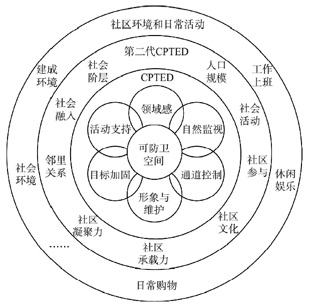
工业革命推动了西方的城市化,同时也产生了许多严重的社会问题。许多发达国家城市采取了大量的应对措施,也积累了大量的经验和教训。而当一些以“威慑理论”为基础的措施走入“死巷”或陷入“瓶颈”之后,解决犯罪问题的传统思路,逐渐由先前的“专业机构的事后应对”转向现代的“综合领域的事前防控”[59]。一些****开始重新审视环境影响犯罪行为的作用及意义,并希望将犯罪治理寄托于城市物质空间环境的改造。正如Newman[60]所说既然我们不能遏制人的犯罪动机,何不从犯罪目标和条件上限制犯罪。因为尽人皆知,没有犯罪作案的目标和条件,犯罪是不可能发生的。基于综合视角,研究不同尺度下的城市犯罪与其社会环境及建成环境的关系,是犯罪地理学的重要内容之一。一般而言,综合视角的研究是以整合日常活动理论、CPTED理论及可防卫空间等理论为基础。日常活动理论包括3类要素:① 有动机的犯罪分子,② 合适的目标,③ 监管者缺失[8]。Cohen等[8]认为当有动机的犯罪分子和有吸引力的受害者在缺乏有效监管的地方相遇时便有可能发生犯罪。该理论关注犯罪机会的变化如何影响犯罪事件的发生,假定不同个体或家庭的日常活动影响犯罪发生的可能性,并强调日常活动场所在犯罪过程中的关键作用。尔后,一些****基于日常活动理论进行了大量的实证研究。如Eck等[61]详细解释了街角、住址、建筑以及街段等场所的犯罪发生机理。Lockwood[62]发现商服、办公、零售等用地与抢劫、伤害犯罪间具有显著的正向关系。Breetzke等[63]研究发现南非茨瓦内的门禁小区对入室盗窃具有显著正向影响,并认为这是由其独特的社会政治历史所诱致。一些研究也证明了自然环境和建成环境特征影响犯罪三要素的时空交汇[64-67]。
CPTED理论包括6类要素:① 领域感,② 自然监视,③ 通道控制,④ 形象与维护,⑤ 活动支持,⑥ 目标加固(图1)[68]。CPTED理论最初的研究者可追溯到Jacobs[69]、Jeffery等[70-71]、Newman等[60, 72]****。Jacobs[69]认为在街道两旁布置足够多的商店、饭店等公共场所,可以增加街道活动对街道的自然监视,让休闲其中的居民去关注陌生人和异常行为,从而遏制社区犯罪的发生。Jeffery等[70-71]强调在环境规划的设计阶段,通过对物质空间环境和非物质空间环境的合理设计与有效利用,进而可以减少犯罪行为的发生。可防卫空间理论包括4类要素:领域感、自然监视、形象和维护和地理邻近性(地理环境)[3, 73]。因此,可防卫空间理论的许多概念是CPTED理论的核心。Newman等[60, 72]认为高层住宅曲折蜿蜒的内部通道和自然监视较弱的公共区域是导致犯罪数量增多的原因。此后,Newman的计划得到美国住房和城市发展部及司法部的大力支持,被运用到美国西屋公司的项目中去。随着理论的广泛应用,可防卫空间理论得到进一步细化与修正,添加了社会维度[3, 73-74],由此形成“第二代CPTED”。在Cozens[83]的基础上,作者结合ZG市“地情”,提出图1所示的概念框架。
 显示原图|下载原图ZIP|生成PPT
图1概念框架
-->Fig. 1Conceptual framework
-->
一些****在CPTED理论发展中也做了相应贡献。如Brantingham等[75]在“边界地带假说”中认为,犯罪高发的城市空间大多处于性质不同的街区的边缘地带,主要原因是这些地区的通道控制较弱,流入其中的人、物、财、信息等城市要素较多,它们扮演“犯罪产生地”和“犯罪吸引地”的双重角色;王发曾等[52-53]在“城市犯罪空间盲区学说”中,强调城市空间环境内部的自我约束和外部的自然监视,认为私人住宅、单元式公寓和企事业单位等非公共空间的内部联系通道,以及外部出入口对犯罪均有影响;Telep[76]结合案例联合分析法研究网格(地点)的社区类型、建筑楼层、活动场所、交通设施等地理环境构型与犯罪热点的逻辑关系;毛媛媛等[77]认为人口密度、用地性质、建筑容积率、商业密集度等与犯罪密度具有相关性;Brown等[78]发现租户较多的社区与物质环境破败的住宅(街区)的犯罪率较高,但提升其社会凝聚力可以缓冲这些因素的影响。然而,CPTED理论因涉及社会、经济、人口与空间环境等多方面内容,在当时很难实施就不被社会所认可[79]。当时Newman[60]的可防卫空间理论,主要关注的是物质空间环境,且系统阐释了城市设计与犯罪预防的关系,因理念具有较强的可操作性便得到了广泛应用。
然而,随着西方社会进入了后工业化时期,人们发现仅依靠规划物质空间环境去遏制城市犯罪仍具有较大的局限性。因此,一些****开始对CPTED理论提出了质疑。如Wilcox等[80]建议在关注CPTED理论和可防卫空间理论的同时,也应重视社会、经济、人口、文化等社会环境因素对犯罪的影响。Cozen等[81]在认可CPTED理论的同时,也提出了它的局限性。他认为邻里关系的冷漠会对犯罪防控具有一定的限制作用,居民社区参与的缺乏而过分依赖目标加固的CPTED措施,将可能会使具有“堡垒心理”的居民,躲在高墙围合及门窗加固的室内,从而形成社区自然监视的缺乏。此后,一些****认为CPTED理论过于简单而应用有限,并尝试在对其解析中进行重构[82-83]。因此,在影响社区犯罪的因素中,除建成环境之外,还应考虑社会环境等方面。结合文献梳理,本文提炼出图1所示的概念框架,据此作为后文分析的基础。
3 研究区域与方法
3.1 研究区域与数据
研究区位于中国东南沿海特大城市ZG市ZH半岛。ZH半岛是一个独立的行政区域(图2),总面积约92 km2,辖有18条行政街,257个社区。近年来,ZH半岛经济增速较快,2014年GDP为1251.5亿元,同比增长9.3%。ZH半岛常住人口不断增加,其中外来人口增速最快,据第六次人口普查数据显示,常住人口155.9万,占全市的12.3%;外来人口60.6万,占全市的12.7%。ZH半岛位于ZG市南部,四面环水,河网密布,交通便捷。岛内社区类型丰富,包括商品房社区、公租房社区① (①2015年ZG市实施公共租赁住房保障政策后,将以前的廉租房、经适房等政策性保障住房统一合并为公共租赁住房。)、单位社区、旧城社区和城中村及其他社区。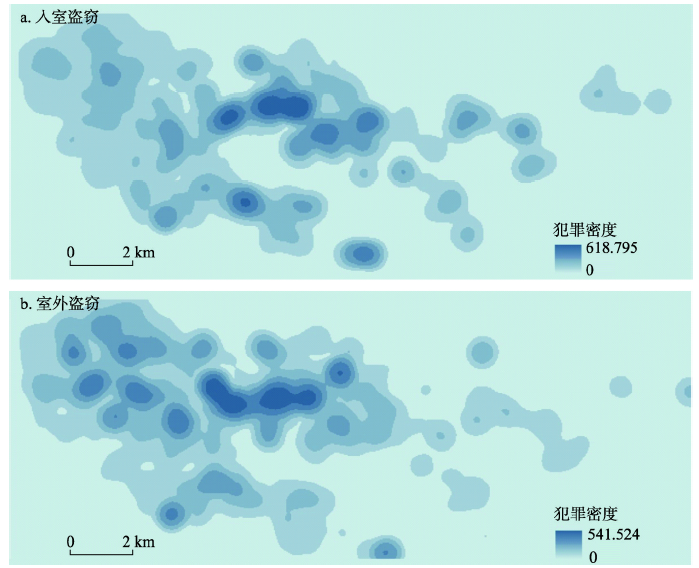 显示原图|下载原图ZIP|生成PPT
图2ZH半岛入室盗窃和室外盗窃犯罪的密度分布
-->Fig. 2The distribution density of burglary and outdoor-theft in ZH peninsula
-->
研究数据来源于多源时空数据,主要包括警情数据,POI数据,人口普查数据和交通路网等基础地理数据。其中,警情数据由ZG市公安局提供的2014年110接警数据,该数据记录了案件类型,案发时间、地点坐标及接警单位等属性信息。从图2可以看出ZH半岛的入室盗窃和室外盗窃空间分布趋向中东部,且两者形态比较相似。POI数据由课题组采购的ZG市2014年“道道通”导航电子地图数据,包括各类商业设施、娱乐设施、餐饮住宿、物流仓储等场所数据。人口普查数据为ZG市2010年第六次人口普查数据,该数据以社区为尺度,主要统计社区总人口、社区外来人口、社区青少年人口,社区在校人数等社会属性②(② 社区的人口普查数据主要统计社区的总人口、外来人口、青少年人口、教育等情况,不包括经济属性。)。交通路网数据包括公交站点和道路路网等矢量数据。其他数据如社区范围和边界来源于基础地理数据库。基于ArcGIS 10.3平台将警情数据、POI数据、交通路网等数据采用空间连接方式添加到对应社区中去。
3.2 研究方法
偏最小二乘法(Partial least squaresregression method,PLS)不仅具有多元统计分析的优点,更重要的是能够消除自变量间多重共线性对回归建模的干扰,因此可以避免因素相关所引起的误差,通过构造新的组件作为原始预测变量的线性组合,从而建立一组响应变量y(n×1)与预测变量x(n×m)间的回归模型[84-88]。PLS在建模过程中可同时实现数据结构简化(主成分分析),典型相关分析和线性回归建模,每一个预测变量的回归系数将更容易解释,同时,模型也更易辨识系统信息和噪声[88]。目前,PLS的理论、方法和应用得到了迅速发展,被视为“第二代”回归方法,广泛用于预测研究,如植物生物量预测、神经影像学预测、金融市场预测等领域。PLS的公式如下:(1)x0为原始预测变量x的标准化矩阵,y0为原始响应变量y的标准化矩阵;
(2)xs为预测得分,n×k阶矩阵,是x0 通过线性变换w得到的各成分的矩阵,k为提取成分个数;w为响应变量权重,m×k阶矩阵;
(3)
(4)
PLS通过寻找使
式中:VIPi为第i个预测变量的重要性;m为预测变量个数;k为从预测变量中提取成分个数;ch为第h个成分;R(y, ch)为成分ch对响应变量y的解释能力,等于两者相关系数的平方;whi是轴wh的第i个分量;wh是矩阵
式中:BETA为预测变量的回归系数,BETA的绝对值越大,表明该预测变量对响应变量的影响程度越大,回归系数为正时,表明两者正相关,反之也成立;RES为残差。
4 社区环境对入室盗窃和室外盗窃的影响分析
以中国东南沿海地区ZG市ZH半岛为例,融合多源异构时空数据,利用偏最小二乘法,检验社区尺度下的社会环境和建成环境,对入室盗窃和室外盗窃的影响进行对比分析。4.1 变量选取
模型自变量选择遵循科学、客观、典型及数据可得性等原则,结合城市犯罪和社区环境互动关系的内涵,根据上述犯罪文献的系统梳理,综合考虑居民社会属性的同时,也考察不同地理背景下建成环境特征的影响。如社会环境方面,主要选取人口密度(DPL)、外来人口比重(DMP)、青少人口比重(DYP)、居民文化程度(REL)等因子。建成环境方面,主要选取道路网络密度(DRN)、公交站点密度(DBS)、零售商业密度(DCR)、娱乐设施密度(DEV)、餐饮住宿密度(DHR)以及到主中心的距离(DCC)。模型因变量为入室盗窃犯罪率(CRburg)和室外盗窃犯罪率(CRthef)(表1)。模型计算均在MATLAB 2014b软件下完成。Tab. 1
表1
表1自变量和因变量的描述
Tab. 1Descriptive of dependent and independent variables
| 变量 | 变量描述和计算方法(编码) | 平均值 | 标准差 | 最小值 | 最大值 |
|---|---|---|---|---|---|
| 入室盗窃犯罪率(件/万人) | 各社区入市盗窃的案件数/社区总人口(CRburg) | 23.000 | 0.0038 | 0.000 | 342.000 |
| 室外盗窃犯罪率(件/万人) | 各社区室外盗窃的案件数/社区总人口(CRthef) | 28.000 | 0.0036 | 0.000 | 219.000 |
| 社会环境 | |||||
| 人口密度(万人/km2) | 各社区总人口/社区总面积(DPL) | 4.881 | 2.641 | 0.263 | 14.655 |
| 外来人口比重(%) | 各社区外来人口总数/各社区总人口(DMP) | 0.476 | 0.220 | 0.092 | 1.000 |
| 青少年人口比重(%) | 各社区青少年人口总数/各社区总人口(DYP) | 0.231 | 0.100 | 0.127 | 0.776 |
| 居民文化程度(%) | 各社区高中文化以上人数/各社区总人口(REL) | 0.552 | 0.167 | 0.062 | 0.975 |
| 建成环境 | |||||
| 道路网络密度(km/km2) | 各社区道路总长度/社区总面积(DRN) | 17.068 | 9.214 | 4.299 | 67.555 |
| 公交站点密度(个/km2) | 各社区公交站点个数/社区总面积(DBS) | 16.391 | 16.691 | 0.000 | 92.715 |
| 零售商业密度(个/km2) | 各社区零售商业个数/社区总面积(DCR) | 180.372 | 185.124 | 5.338 | 1594.579 |
| 娱乐设施密度(个/km2) | 各社区娱乐设施个数/社区总面积(DEV) | 10.645 | 13.301 | 0.000 | 76.931 |
| 餐饮住宿密度(个/km2) | 各社区餐饮住宿个数/社区总面积(DHR) | 44.550 | 45.581 | 0.000 | 276.951 |
| 到主中心的距离(km) | 各社区中心到主中心的距离(DCC) | 3.746 | 1.764 | 0.000 | 7.247 |
新窗口打开
4.2 影响因素的整体特征分析
通过对各社区入室盗窃犯罪率、室外盗窃犯罪率与其影响因素的PLS回归分析,得到各因子VIP值和BETA值(图3)。入室盗窃、室外盗窃的调整R2(R2)分别为0.551(0.568)、0.518(0.542),说明模型拟合度较好。研究发现,在社区环境的总体框架下,社会环境和建成环境分别对入室盗窃影响VIP值大于0.8的因素有3个、2个,即人口密度、青少年人口比重、居民文化程度与公交站点密度、到主中心的距离;而对室外盗窃影响VIP值大于0.8的因素依次为2个、5个,前者如人口密度、青少年人口比重,后者为道路网络密度、公交站点密度、零售商业密度和餐饮住宿密度以及到主中心的距离。因此,比较而言,在建成环境背景下,入室盗窃的影响因素相对集中,而室外盗窃的影响因素较为分散。主要原因是它们发生的微观场所有些差异,相对而言,发生在户外的盗窃更易受建成环境的影响,如犯罪目标的易接近性、易暴露性,罪后逃逸的便捷性,社区混合度以及地区活跃度等方面的影响。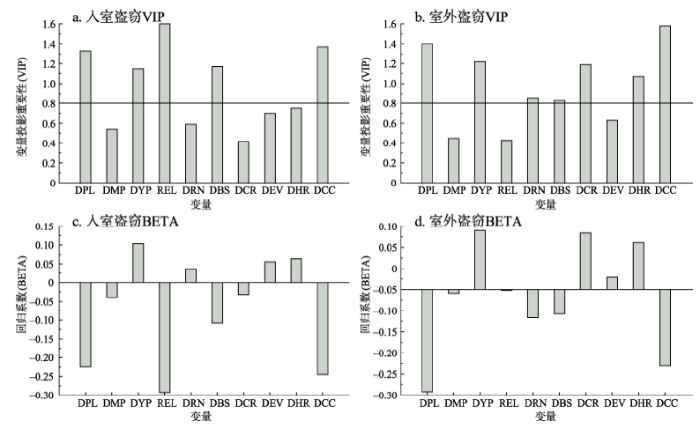 显示原图|下载原图ZIP|生成PPT
图3ZH半岛入市盗窃和室外盗窃的VIP值和BETA值
-->Fig. 3VIP and BETA value of influencing factors for burglary and outdoor-theft crimes in ZH peninsula
-->
4.3 社会环境对入室盗窃和室外盗窃的影响
研究发现,人口密度、外来人口比重、青少年人口比重、居民文化程度对入室盗窃影响的VIP值(BETA值)分别为1.33(-0.224)、0.54(-0.039)、1.15(0.103)、1.60(-0.292),对室外盗窃影响的VIP值(BETA值)分别为1.40(-0.242)、0.45(-0.009)、1.22(0.140)、0.43(-0.002)(图3)。其中,人口密度对入室盗窃和室外盗窃的影响方向均为负(负BETA值),即在社区尺度,ZH半岛各社区的人口密度越大,这两类犯罪率反而越低。这一发现与西方一些研究不一致。如Newman等[60, 72]和Andresen[34]认为人口密度或规模越大,将会增加潜在犯罪者和犯罪目标的接触机会,有利于犯罪的发生。根据ZH半岛的实际情况,人口密度大的社区多数是商品房和公租房等高层社区。现从3个方面进行解释:① 商品房社区的防卫能力强。在实地调研中发现,商品房等高层社区的外围由高墙、铁栏围合而成,其内、外视频监控系统(CCTV)布局合理且运行正常,并内时有巡逻人员,进出社区需刷卡或登记,因此,外来人员进入比较困难。课题组成员也在截访中多次经历了被驱离的尴尬。这说明了其物业管理和安保水平相对较高,能够有效阻止潜在犯罪者进入社区内部实施犯罪;② 公租房社区具有防御“搭便车效应”。即ZG市ZH半岛的公租房社区并不是整片独立布局,而是配套间隔安置于商品房社区或其部分楼层中,因此形成了良好的防御“搭便车效应”;③ 正式或非正式社会控制。在ZH半岛人口密度高的社区,因稳定需要,警务人员数量和日常巡逻量也相对较多。另外,Cahill[32]认为人口密度的增加,可以增加彼此间的自然监控,从而限制犯罪发生,这符合Jacobs[69]的“街道之眼”理论。同时,按照“阈值假设”[38],Newman和Andresen的研究符合其西方背景,发达国家人少地多,相较于人口低密度社区,高密度人口社区的犯罪目标相对较多,这对潜在犯罪者的吸引力也就越大,但对中国特大城市的社区来说,不存在吸引潜在犯罪者的“目标阈值”问题。
外来人口比重对入室盗窃和室外盗窃影响的VIP值都小于0.8(图3),说明了其影响效果并不明显。这一结果与西方研究也不一致。国外Andresen[89]和Johnson等[58]的研究发现,由种族移民、流动人口所形成社会异质性较高的亚文化社区,因文化差异而受地方的排斥,进而导致经济、社会的排斥,这些社区犯罪率相对较高。结合ZG市的现实情况,本文认为许多社区外来人口并不能完全等同于流动人口或“西方移民”,也不全是文化水平相对较低“易犯罪”的“农民工”或“新生代农民工”,更不是流串作案的犯罪分子。随着ZG市2008年以来“退二进三”产业结构调整政策的实施,现今,在ZH半岛内的许多外来常住人员,在ZG市主要从事各种商贸服务、技术研发、个体经商或交流学习。这些外来人口与本地人口以汉族居多,虽然在方言、习俗等方面存在个体差异,但并不完全像西方国家“多元文化、种族隔阂”所形成的较难调和的异质社会。对比入室盗窃和室外盗窃犯罪嫌疑人的抓捕数据,发现不仅有外地犯罪分子,也有本地犯罪分子。结合与警员的交流访谈,了解到许多案件的犯罪分子确属流串外地作案,其中,以本地“二世祖”为纽带的流动人口犯罪更为突出。因此,本文中的外来人口比重对入市盗窃和室外盗窃影响不显著的这一发现,也有它的合理性。
青少年人口比重对入室盗窃和室外盗窃影响的VIP值分别为1.15、1.22(图3),均远大于0.8,说明青少年人口比重对这两类犯罪均有影响且效应为正,即社区青少年人口比重越大,犯罪率就越高,这与西方的研究保持一致。如Browning等[38]分析了年龄结构与犯罪的关系,发现青少年比例与犯罪具有正向关系。Clarke等[11]在对青少年心理研究中发现,他们的违法行为主要与当地居住环境的情境因素有关。比对入室盗窃和室外盗窃犯罪嫌疑人的抓捕数据(挑选出青少年人口),本文发现ZH半岛青少年犯罪主要集中于城中村和旧城社区。现从其形成机制方面加以解释:① 社区凝聚力、邻里关系和社会融入。城中村和旧城社区具有3个鲜明的特性,即人口外源性、文化异构性、群体弱势性,内部间的邻里关系冷漠,社区凝聚力、社会融入度较差。因此,在非正式防控力量薄弱的情景下,青少年在这些缺少“街道监视”的社区变得“更加大胆,肆意妄为,屡次偷盗”;② 社区公益活动设施的缺乏。在城中村和旧城社区因缺乏社会公益和文化娱乐设施,造成了青少年正常交流活动减少,增加了他们犯罪的“时间机会”;③ “放任自流”的管理方式。政府“堆垃圾”政策导致了问题家庭和问题人群的集中[59]。这些方面均直接或间接地影响青少年犯罪。
居民文化程度对入室盗窃影响的VIP值为1.60,BETA值为-0.292,对室外盗窃影响的VIP值为0.43,BETA值为-0.002(图3),这说明居民文化程度对入室盗窃具有显著影响且效应为负,而对室外盗窃几乎无影响。相对盗窃来说,入室盗窃是一种性质更为严重的侵财犯罪,不仅危害公民的财产安全,更为凸显的是容易转为性质恶劣的杀人、强奸等刑事犯罪。因此,结合居民的防护能力和犯罪成本来对其解释:① 居民自身的防护能力。一般而言,社区居民文化程度越高,会越关注自身和所拥有的财产安全,通常会采取目标加固的手段,如安设防盗门窗,或与邻里协商在楼宇进入口设立电子门禁,这可起到限制外部人员轻易进入的防控作用;② 犯罪成本。相对而言,居民文化程度越高,其所得合法工资收益也会越高,从而增加了实施犯罪的机会成本或处罚成本。此外,具有较高文化程度的居民的道德标准也会较高,这会增加他们实施犯罪的心理成本。因此,居民文化水平的提高对入室盗窃的发生具有抑制作用,而对室外盗窃的影响不明显,可能是与其犯罪机会的遍在性或犯罪风险小有关,这将在今后研究中进一步明确。
4.4 建成环境对入室盗窃和室外盗窃的影响
建成环境方面,对入室盗窃和室外盗窃都有显著影响的因子是公交站点密度和到主中心的距离。公交站点密度对入室盗窃和室外盗窃影响的VIP值(BETA值)分别为1.17(-0.108)、0.83(-0.058),因此,公交站点密度对这两类犯罪具有显著的负向作用。目前国内外在这方面的研究文献较少,仅有少量****进行了相关分析,如Yu[90]在美国纽瓦克市的研究中发现,入室盗窃率与公交站点密度具有正相关。针对ZH半岛的研究与西方不一致的结论,可从两个方面进行解释:① 视频监控的威慑作用。ZH半岛的公交站点附近基本上都安装了视频监控系统,形成了覆盖公交站点的“天网工程”,对公交站点进行全天候监控。因此,对“记录在案”、“流串作案”等犯罪分子起到一定的威慑作用,迫使他们远离视频监控较密集的社区作案;② 非正式社会控制的作用。在调研中发现,公交站点密度相对较高的社区,其沿街店铺和商场较多,按照“街道眼理论”,因街道活动的增加,提升了人们对异常行为的关注度,以及店主对陌生人的警惕,从而对犯罪起着压制作用[69]。另外,到主中心的距离对入室盗窃和室外盗窃影响的VIP值(BETA值)分别为1.37(-0.245)、1.58(-0.180),均大于0.8。因此,其对入室盗窃和室外盗窃的影响为负且显著,这点符合距离衰减效应,也与国内外研究一致。道路网络密度对室外盗窃影响的VIP值(BETA值)为0.86(-0.067),说明了其对室外盗窃具有显著的负向影响,即社区道路网络密度越高,室外盗窃率越低,而对入室盗窃的影响不显著(VIP<0.8)。ZH半岛的这一发现与国外最近的研究一致,如Law等研究了加拿大安大略省约克区(约89万居民)的暴力犯罪和侵财犯罪,发现青少年犯罪与道路网络密度具有负的相关性[40]。对ZH半岛部分道路网络密度较高社区的调研中发现,这些道路两侧的城市林荫道较为开阔齐整,有不少老年人、带小孩等人群在林荫道旁休闲散步。这增加了人在街道空间的停留时间,也相应增加了对街道空间的自然监控,从而提高了潜在犯罪者实施犯罪行为被发现的可能性。另一方面,街道的宜居环境,能够增强社区居民间的熟悉程度,间接地提高了居民的公共依恋感和公共责任感,以及激发更好的社会监控。
零售商业密度、餐饮住宿密度对室外盗窃影响的VIP值(BETA值)分别为1.19(0.134)、1.07(0.111),也均大于0.8,说明它们对室外盗窃具有显著的正向影响,而对入室盗窃的影响不显著(VIP<0.8)。根据日常活动理论,零售商业和餐饮住宿等日常活动场所能吸引更多的人群,到此进行购物、餐饮、休闲等活动,这就增加了潜在犯罪者与犯罪目标的时空交互机会;同时也提升地方汇聚商品与货物的能力,将会吸引更多的潜在犯罪者[8],从而增加室外盗窃的可能性。因此,这些场所扮演了“犯罪吸引地”的角色。ZH半岛的这一结果符合西方的两大经典理论。如Lockwood[62]结合日常活动理论的研究,发现商服、零售的用地规模与犯罪间具有显著的正相关性。Wilcox等[80]基于社会解体理论的分析,发现商业等用地能吸引更多的陌生人群,从而模糊了居民对社区的领域感,并阻碍形成有效的非正式控制,最终会增加犯罪发生的可能性。最后,研究发现娱乐设施密度对入室盗窃和室外盗窃的VIP值分别为0.70、0.63,较接近于0.8。这说明娱乐设施密度对其虽有影响,但效果并不显著。可能原因之一,从表1可知,相较于ZH半岛的零售商业和餐饮住宿,各社区的娱乐设施数量较少,而在现实生活中,ZG市的酒吧、迪吧等娱乐场所主要分布在其他两个地区。因此,娱乐设施这一变量将以后在ZG市其他区域中加以验证。
综上,本文尝试以日常活动理论、CPTED理论、可防卫空间等理论为基础,检验了社区尺度下的建成环境和社会环境对入室盗窃和室外盗窃的影响,并进行了对比分析,发现ZH半岛的研究具有一定的规律性特征,也较明确了ZH半岛入室盗窃和室外盗窃空间分布的主要影响因素及作用方式。
5 结论和讨论
如何限制犯罪在城市的蔓延依然是人类社会的主要挑战之一。研究表明,如不对犯罪加以压制,那么它就有可能像“痼疾”一样复发及扩散[2]。然而,犯罪现象的时空特征与分析尺度密切相关,这一直是个备受争议的话题。以犯罪地理学为代表,认为对不同犯罪模式的解读应考虑研究尺度并有所甄别,他们认为宏观或中观尺度的研究对把握犯罪总体特征与发展趋势等方面均有着突出的贡献,但分析区域是一个非均质空间,大尺度的研究将会掩盖犯罪活动的微观机理与重要变化。因此,近年来,微观视角的研究受到地理****的重视。本文在对ZG市犯罪数据的地址编码过程中,发现了这一独特现象,即入室盗窃和室外盗窃的案发场地虽有所不同,但其空间分布却有着十分相似的形态,结合空间相关性分析,发现其相关系数为0.825,这一定程度上说明两者间具有较高的空间相关性。如今一些研究虽已表明,社区环境的基本属性是影响城市犯罪的重要因素,但这两类犯罪相似的空间形态受社区环境哪些因素的影响及作用方式如何仍未探寻及验证。因此,本文扎根日常活动理论、CPTED理论、可防卫空间等理论,以ZG市ZH半岛257个社区为例,利用偏最小二乘法,检验社区尺度下的建成环境和社会环境,对入室盗窃和室外盗窃的影响进行对比分析,得到了以下结论:(1)ZH半岛内具有一定的规律性特征,即在建成环境背景下,入室盗窃的影响因素相对集中,而室外盗窃的影响因素较为分散。如入室盗窃VIP值大于0.8的影响因素有2个,而室外盗窃VIP值大于0.8的影响因素有5个,主要原因是它们发生的微观场所有些差异,相对而言,发生在户外的盗窃更易受建成环境的影响,如犯罪目标的易接近性、易暴露性,罪后逃逸的便捷性,社区混合度以及地区活跃度等方面的影响。
(2)ZH半岛内的社会环境和建成环境对两类犯罪的影响及作用力存在着相对的共性和差异性。其共性主要表现在人口密度(-)、青少年人口比重(+)、公交站点密度(-)以及到主中心的距离(-)对入室盗窃和室外盗窃的发生都有显著影响且作用力方向一致;差异性主要体现在道路网络密度(-)、零售商业密度(+)和餐饮住宿密度(+)是影响室外盗窃发生的主要因子,而居民文化程度(-)显著影响入室盗窃的发生。研究结果的引申,或许可为社区层面的入室盗窃和室外盗窃的联合防控提供一些参考。
城市犯罪是一个兼有社会属性的空间问题。中西方国家在社会形态和结构上都有很大的差异,所以对犯罪现象的认知应有所区别。近30多年以来,中国经济建设成就举世惊叹,其城市化进程也令国际瞩目。中国城市发展的速度和程度是西方城市无法比拟的,但其城市空间迅速扩展,急剧征用周边用地,彻底破坏了原来的社会基层组织,无论在物质层面还是精神层面,这一过程往往伴随着各种矛盾的孕育和爆发。研究也表明,影响犯罪的因素内容丰富,相对复杂,既包括直接因素,也包括间接因素,它涉及城市的社会经济,人口产业,文化习俗,土地利用和交通区位等多方面。因此,从不同的学科背景或研究视角所选取的犯罪因子,无论是内容上还是在形式上都有所差异。然而,这种差异的存在是符合客观现实的,也是极其必要的。也正是这种差异的存在,才能促使研究者去更深入理解不同因子在不同情景或条件下对犯罪发生过程和作用方式的影响,才能真正剖析犯罪现象的原因之所在。这不仅有助于理论方法的丰富与完善,也有助于犯罪科学预测及有效防控[22]。因此,基于跨学科、多领域交叉研究,即可以保持犯罪研究的多样性,也可以加快推动学科间的融合发展,这是深化认识水平的科学手段和必然途径。
此外,中国城市犯罪研究表现出与西方不一致的结论,这是由国情差异与地方差异所决定的。鉴于此,有关犯罪格局、过程与机理的研究,均不能脱离当地的经济发展、社会关系、文化背景与建成环境等方面。这也就是说,西方背景下的犯罪发生规律和空间分析手段并非完全通用于非西方下的犯罪分析,为此我们在借鉴西方研究成果的同时,需结合国情和“地情”有所甄别,据此获得更加客观合理的犯罪解析,去重新审视社区环境设计对犯罪预防的作用。
The authors have declared that no competing interests exist.
参考文献 原文顺序
文献年度倒序
文中引用次数倒序
被引期刊影响因子
| [1] | . |
| [2] | . Containing the spread of crime in urban societies remains a major challenge. Empirical evidence suggests that, if left unchecked, crimes may be recurrent and proliferate. On the other hand, eradicating a culture of crime may be difficult, especially under extreme social circumstances that impair the creation of a shared sense of social responsibility. Although our understanding of the mechanisms that drive the emergence and diffusion of crime is still incomplete, recent research highlights applied mathematics and methods of statistical physics as valuable theoretical resources that may help us better understand criminal activity. We review different approaches aimed at modeling and improving our understanding of crime, focusing on the nucleation of crime hotspots using partial differential equations, self-exciting point process and agent-based modeling, adversarial evolutionary games, and the network science behind the formation of gangs and large-scale organized crime. We emphasize that statistical physics of crime can relevantly inform the design of successful crime prevention strategies, as well as improve the accuracy of expectations about how different policing interventions should impact malicious human activity that deviates from social norms. We also outline possible directions for future research, related to the effects of social and coevolving networks and to the hierarchical growth of criminal structures due to self-organization. |
| [3] | . Concern over high crime rates and deteriorating inner-city neighborhoods has reawakened interest in Defensible Space, architect Oscar Newman's groundbreaking physical design approach to crime prevention. Creating Defensible Space, written by Newman and recently published by HUD's Office of Policy Development and Research, draws on Newman's experience carrying out and analyzing Defensible Space projects since the early 1970s. This publication provides an expert review of the Defensible Space concept and three step-by-step case studies to help communities redesign neighborhoods for greater safety. |
| [4] | . |
| [5] | . ABSTRACT This paper examines the geography of violent crime across the neighborhoods of Tucson and South Tucson, Arizona. The research is informed by the tenets of modern social disorganization theory, which has a strong ecological or environmental basis. Three different crime indices are computed; each represents an annual average during the five-year period 1995-1999. The most comprehensive index captures aggravated assaults, homicides, robberies, and sexual assaults. After providing a factor-ecological study of the study area, using 27 variables taken from the 1990 census, various regression models are developed to explain violent crime patterns. These models use a smaller array of ten demographic, economic, and social attributes to predict patterns at the block group level. A number of variables are found to be significant across all models, thereby providing further support for social disorganization theory. Stability in the signs and values of the estimates suggest that a general model of violent crime can be established for the study region. The paper closes with a short discussion of some public policy implications. |
| [6] | . ABSTRACT Police departments, city officials and policy makers all recognize the importance of a better understanding of the dynamics of crime. Both theoretical and applied approaches, or combinations of the two, which provide insight into why and where crime takes place are much in demand. Macrolevel analysis helps to identify problem neighborhoods. Microlevel analysis helps to isolate precise trouble spots within neighborhoods and, as a result, allows for better evaluation of crime and specific socioeconomic, demographic, land use and environmental characteristics associated with these trouble spots. This paper details a framework for better understanding the spatial characteristics of crime based upon the use of geographical information systems (GIS) and quantitative techniques. Lima, Ohio, provides a case study for a number of reasons. Many smaller communities have serious crime problems, so the study of crime in these communities is much needed. Lima (population 40,263) has violent crime rates well above average for its size, experiencing rates of violent crime equal to or above larger cities such as Columbus, Cincinnati and Toledo. Also, crime has an inordinately strong influence in the social and economic performance of small cities and hinders economic recovery efforts. The establishment of an analytical and theoretical framework for evaluating the relationship between aspects of place and the clustering of crime will undoubtedly lead to enhanced crime prevention strategies. |
| [7] | |
| [8] | . It is hypothesized that the dispersion of activites away from households and families increases the opportunity for crime and thus generates higher crime rates. Data on changes in such variables as labor force participation and household composition are used to support the hypothesis. (Author/RLV) . |
| [10] | |
| [11] | . In: |
| [12] | . In the mid-1970s, the state of New Jersey announced a "Safe and Clean Neighborhoods Program," designed to improve the quality of community life in twenty-eight cities. As part of that program, the state provided money to help cities take police officers out of their patrol cars and assign them to walking beats. The governor and other state officials were enthusiastic about using foot patrol as a way of cutting crime, but many police chiefs were skeptical. Foot patrol, in their eyes, had been pretty much discredited. It reduced the mobility of the police, who thus had difficulty responding to citizen calls for service, and it weakened headquarters control over patrol officers. |
| [13] | // Restricted access |
| [14] | . 当前社会犯罪问题严峻,以空间为视角的犯罪地理研究因其独特的综合性在犯罪防控中的作用日益凸显。以中国知网、维普和万方三大数据库中获得的期刊文献为基础,对中国犯罪地理的研究状况进行综合评述。在对国内五大研究主题进行回顾的基础上,围绕"研究主题"和"研究领域"两方面,分析了中国犯罪地理学的发展动态。总体来看,在过去的25年中,中国犯罪地理研究逐渐起步,发展趋势良好,已经吸引了来自地理学、法学与警务管理、城市规划、应用数学等诸多领域的****关注。尽管研究焦点各有侧重,但始终注重对国外研究和实践经验的引入,并提出了基于综合分析、情境预防、CPTED、PGIS的诸多防控对策。在犯罪时空分布特征、犯罪发生诱因等方面,研究范围宽广,但研究深度有待加强。未来中国犯罪地理学发展任重而道远。学界应充分重视城市犯罪与农村犯罪、犯罪与微观环境的互动关系、犯罪主体的行为空间等研究,并积极探索虚拟犯罪模拟新技术的应用。 . 当前社会犯罪问题严峻,以空间为视角的犯罪地理研究因其独特的综合性在犯罪防控中的作用日益凸显。以中国知网、维普和万方三大数据库中获得的期刊文献为基础,对中国犯罪地理的研究状况进行综合评述。在对国内五大研究主题进行回顾的基础上,围绕"研究主题"和"研究领域"两方面,分析了中国犯罪地理学的发展动态。总体来看,在过去的25年中,中国犯罪地理研究逐渐起步,发展趋势良好,已经吸引了来自地理学、法学与警务管理、城市规划、应用数学等诸多领域的****关注。尽管研究焦点各有侧重,但始终注重对国外研究和实践经验的引入,并提出了基于综合分析、情境预防、CPTED、PGIS的诸多防控对策。在犯罪时空分布特征、犯罪发生诱因等方面,研究范围宽广,但研究深度有待加强。未来中国犯罪地理学发展任重而道远。学界应充分重视城市犯罪与农村犯罪、犯罪与微观环境的互动关系、犯罪主体的行为空间等研究,并积极探索虚拟犯罪模拟新技术的应用。 |
| [15] | // Social scientists have had a long and enduring interest in the geography of crime and the explanation of variation of crime at place. In this introductory chapter, we first describe the history of cri |
| [16] | . Over the last 40years, the question of how crime varies across places has gotten greater attention. At the same time, as data and computing power have increased, the definition of a ‘place’ has shifted farther down the geographic cone of resolution. This has led many researchers to consider places as small as single addresses, group of addresses, face blocks or street blocks. Both cross-sectional and longitudinal studies of the spatial distribution of crime have consistently found crime is strongly concentrated at a small group of ‘micro’ places. Recent longitudinal studies have also revealed crime concentration across micro places is relatively stable over time. A major question that has not been answered in prior research is the degree of block to block variability at this local ‘micro’ level for all crime. To answer this question, we examine both temporal and spatial variation in crime across street blocks in the city of Seattle Washington. This is accomplished by applying trajectory analysis to establish groups of places that follow similar crime trajectories over 16years. Then, using quantitative spatial statistics, we establish whether streets having the same temporal trajectory are collocated spatially or whether there is street to street variation in the temporal patterns of crime. In a surprising number of cases we find that individual street segments have trajectories which are unrelated to their immediately adjacent streets. This finding of heterogeneity suggests it may be particularly important to examine crime trends at very local geographic levels. At a policy level, our research reinforces the importance of initiatives like ‘hot spots policing’ which address specific streets within relatively small areas. |
| [17] | . ABSTRACT Recent research in the ‘‘crime at places’’ literature is concerned with smaller units of analysis than conventional spatial criminology. An important issue is whether the spatial patterns observed in conventional spatial criminology focused on neighborhoods remain when the analysis shifts to street segments. In this article, the authors use a new spatial point pattern test that identifies the similarity in spatial point patterns. This test is local in nature such that the output can be mapped showing where differences are present. Using this test, the authors investigate the stability of crime patterns moving from census tracts to dissemination areas to street segments. The authors find that general crime patterns are somewhat similar at all spatial scales, but finer scales of analysis reveal significant variations within larger units. This result demonstrates the importance of analyzing crime patterns at small scales and has important implications for further theoretical development and policy implementation. |
| [18] | . ABSTRACT Many offenses take place close to where the offender lives. Anecdotal evidence suggests that offenders also might commit crimes near their former homes. Building on crime pattern theory and combining information from police records and other sources, this study confirms that offenders who commit robberies, residential burglaries, thefts from vehicles, and assaults are more likely to target their current and former residential areas than similar areas they never lived in. In support of the argument that spatial awareness mediates the effects of past and current residence, it also is shown that areas of past and present residence are more likely to be targeted if the offender lived in the area for a long time instead of briefly and if the offender has moved away from the area only recently rather than a long time ago. The theoretical implications of these findings and their use for investigative purposes are discussed, and suggestions for future inquiry are made. |
| [19] | . |
| [20] | . Researchers in the spatial analysis literature commonly aggregate crime types: property, violent, and total crime, for example. This practice is done for a number of reasons that range from low crime counts to confidentiality to the form of data provided to researchers. But is this practice appropriate, particularly in the context of studying spatial patterns? In this paper, we analyze the appropriateness of such crime type aggregations. We find that in almost all cases, aggregating crime types is inappropriate for polygon-based analyses. Only in the cases of micro-spatial units of analysis (street segments) may these aggregations be appropriate. Therefore, aggregating crime types in a study that implicitly or explicitly considers the spatial patterns of crime is inappropriate. |
| [21] | . 选取H市中心城区DP半岛作为研究区域,以岛上2006-2011年发生的街头抢劫案件(共373起)作为研究对象,将DP半岛内街头抢劫案件的时空分布特征分别从宏观和局部微观两个尺度层面进行系统的分析.首先,对岛上的街头抢劫案件按年、月和小时进行统计分析,总结其在不同时间尺度上的变化规律:2007年开始的严打使案件数量逐年减少,直到2010年才略有回升;春节期间(二月前后)的案件数量明显高于其他月份;晚上22:00-23:00期间是案件高发时段.其次,利用Kernel密度方法对研究区街头抢劫犯罪的宏观空间分布进行整体的辨别,剥离出犯罪热点空间分布,分析热点与道路网和土地利用的关联性,结果表明热点多分布于主干道、通达性高的节点或土地利用混合度高的地方.最后,选出4个最主要的热点从微观尺度进行分析,PAI指数表明这4个热点在时间上是稳定的,从2006年到2011年一直存在.依据“热点时空类型矩阵”的时间分布和空间分布模式,将这4个稳定热点归类到不同微观时空模式,并对每类模式下的街头抢劫犯罪提出有针对性的防控对策,以便优化警力资源的配置、最大限度抑制和减少犯罪的发生. . 选取H市中心城区DP半岛作为研究区域,以岛上2006-2011年发生的街头抢劫案件(共373起)作为研究对象,将DP半岛内街头抢劫案件的时空分布特征分别从宏观和局部微观两个尺度层面进行系统的分析.首先,对岛上的街头抢劫案件按年、月和小时进行统计分析,总结其在不同时间尺度上的变化规律:2007年开始的严打使案件数量逐年减少,直到2010年才略有回升;春节期间(二月前后)的案件数量明显高于其他月份;晚上22:00-23:00期间是案件高发时段.其次,利用Kernel密度方法对研究区街头抢劫犯罪的宏观空间分布进行整体的辨别,剥离出犯罪热点空间分布,分析热点与道路网和土地利用的关联性,结果表明热点多分布于主干道、通达性高的节点或土地利用混合度高的地方.最后,选出4个最主要的热点从微观尺度进行分析,PAI指数表明这4个热点在时间上是稳定的,从2006年到2011年一直存在.依据“热点时空类型矩阵”的时间分布和空间分布模式,将这4个稳定热点归类到不同微观时空模式,并对每类模式下的街头抢劫犯罪提出有针对性的防控对策,以便优化警力资源的配置、最大限度抑制和减少犯罪的发生. |
| [22] | [D]. [D]. |
| [23] | . Abstract Properties, victims, and locations previously targeted by offenders have an increased risk of being targeted again within a short time period. It has been suggested that often the same offenders are involved in these repeated events and, thus, that offenders prior crime location choices influence their subsequent crime location choices. This article examines repeated crime location choices, testing the hypothesis that offenders are more likely to commit a crime in an area they previously targeted than in areas they did not target before. Unique data from four different data sources are used to study the crime location choices of 3,666 offenders who committed 12,639 offenses. The results indicate that prior crime locations strongly influence subsequent crime location choices. The effects of prior crime locations are larger if the crimes are frequent, if they are recent, if they are nearby, and if they are the same type of crime. |
| [24] | . ABSTRACT Objectives: In small-scale, intra-urban communities, do fundamental demographic correlates of crime, proven important in community criminology, link to next year’s crime levels, even after controlling for this year’s crime levels? If they do, it would imply that shifting ecologies of crime apparent after a year are driven in part by dynamics emerging from structural differentials. To the best of the authors’ knowledge, this question has not yet been addressed. |
| [25] | . ABSTRACT A leading sociological theory of crime is the “routine activities” approach (Cohen and Felson, 1979). The premise of this ecological theory is that criminal events result from likely offenders, suitable targets, and the absence of capable guardians against crime converging nonrandomly in time and space. Yet prior research has been unable to employ spatial data, relying instead on individual- and household-level data, to test that basic premise. This analysis supports the premise with spatial data on 323,979 calls to police over all 115,000 addresses and intersections in Minneapolis over 1 year. Relatively few “hot spots” produce most calls to Police (50% of calls in 3% of places) and calls reporting predatory crimes (all robberies at 2.2% of places, all rapes at 1.2% of places, and all auto thefts at 2.7% of places), because crime is both rare (only 3.6% of the city could have had a robbery with no repeat addresses) and concentrated, although the magnitude of concentration varies by offense type. These distributions all deviate significantly, and with ample magnitude, from the simple Poisson model of chance, which raises basic questions about the criminogenic nature of places, as distinct from neighborhoods or collectivities. |
| [26] | . ABSTRACT Using variables recorded by the police on when and where violent crime and disorder occur, the paper emphasizes the value of using a combination of different types of micro-spatial information in identifying patterns of violence. Evidence from Cardiff and Worcester shows primary clusters at night in the pub/club leisure zones; and secondary clusters during the shopping day in major retail streets. Disorder data also reveal subsidiary afternoon clusters near licensed premises, and a late-night confluence flashpoint at a node of pedestrian activity. Police geographical information systems should incorporate precise spatial and temporal variables to enhance our understanding of violent crime, to facilitate targeted policing and to assist in creating safer city centres. |
| [27] | . 城市犯罪的时空模式是地理学"格局"和"过程"研究的重要话题。本文以北京城八区为研究对象,利用GIS工具获取和处理空间数据,以"犯罪密度"对犯罪与地域关联的空间特征进行量化表征,并建立城市犯罪时空机制模型。研究发现:北京城市犯罪空间分布总体符合同心圆模型的圈层结构特点;最大犯罪密度地区在复兴门外、广安门、北京西站一带,以及王府井、建国门至朝阳门外一带;城市犯罪嫌疑人数量和不同犯罪类型出现地点数量存在年际变化,但是各城区总的犯罪地点数目和各自的犯罪密度具有一定的稳定性,从而验证了西方****关于"犯罪地点稳定性"的论断;场所的时空特征作用于财产犯罪参与者,进而作用于犯罪要素并影响犯罪实施成功与否;不同类型的财产犯罪对场所时空特征要求不同,这些要求一旦与北京城市空间中的特有属性耦合,便产生某些犯罪类型高发区,间接影响了城市空间的结构特点。 . 城市犯罪的时空模式是地理学"格局"和"过程"研究的重要话题。本文以北京城八区为研究对象,利用GIS工具获取和处理空间数据,以"犯罪密度"对犯罪与地域关联的空间特征进行量化表征,并建立城市犯罪时空机制模型。研究发现:北京城市犯罪空间分布总体符合同心圆模型的圈层结构特点;最大犯罪密度地区在复兴门外、广安门、北京西站一带,以及王府井、建国门至朝阳门外一带;城市犯罪嫌疑人数量和不同犯罪类型出现地点数量存在年际变化,但是各城区总的犯罪地点数目和各自的犯罪密度具有一定的稳定性,从而验证了西方****关于"犯罪地点稳定性"的论断;场所的时空特征作用于财产犯罪参与者,进而作用于犯罪要素并影响犯罪实施成功与否;不同类型的财产犯罪对场所时空特征要求不同,这些要求一旦与北京城市空间中的特有属性耦合,便产生某些犯罪类型高发区,间接影响了城市空间的结构特点。 |
| [28] | . Abstract Burglary victimization is associated with a temporary elevated risk of future victimization for the same property and nearby properties. Previous research suggests that often the initial and subsequent burglaries involve the same offenders. This paper tests this assertion, using data on detected residential burglaries during the period 1996鈥2004 in The Hague and its environs, in the Netherlands. It demonstrates that pairs of detected burglaries occurring in close proximity in space and time are much more likely to involve the same offenders than pairs that are not so related. Topics for future research and implications for the detection of burglaries are addressed. |
| [29] | . ABSTRACT Whilst analysis of crime for tactical and strategic reasons within the criminal justice arena has now become an established need, predictive analysis of crime remains, and probably always will be, a goal to be desired. Opening a window on this over the last 2 decades, prominent research from academia has focused on the phenomenon of repeat victimisation and more recently ‘near repeat’ victimisation, both firmly grounded in the geography of crime. Somewhat limited to the establishment of near repeat behavioural patterns in whole area data, these can be utilised for crime prevention responses on a local scale. Research reported here however, explores the phenomenon through the examination of serial offending by individual offenders to establish if such spatio-temporal patterns are apparent in the spatial behavioural patterns of the individual burglar, and if so how they may be defined and therefore utilised on a micro rather than macro scale. It is hypothesised that offenders' responsible for more than one series of offences will display consistency across their crime series within time and distance parameters for their closest offences in space. Results improve upon current knowledge concerning near repeat offending being the actions of common offenders. Testing of the extracted data indicates that offenders maintain personal boundaries of ‘closeness’ in time and space even when actions are separated by significant time spans, creating stylised behavioural signatures appertaining to their use of and movement through space when offending. |
| [30] | . ABSTRACT Objectives: This study builds on research undertaken by Bernasco and Nieuwbeerta and explores the generalizability of a theoretically derived offender target selection model in three cross-national study regions. Methods: Taking a discrete spatial choice approach, we estimate the impact of both environment- and offender-level factors on residential burglary placement in the Netherlands, the United Kingdom, and Australia. Combining cleared burglary data from all study regions in a single statistical model, we make statistical comparisons between environments. Results: In all three study regions, the likelihood an offender selects an area for burglary is positively influenced by proximity to their home, the proportion of easily accessible targets, and the total number of targets available. Furthermore, in two of the three study regions, juvenile offenders under the legal driving age are significantly more influenced by target proximity than adult offenders. Post hoc tests indicate the magnitudes of these impacts vary significantly between study regions. Conclusions: While burglary target selection strategies are consistent with opportunity-based explanations of offending, the impact of environmental context is significant. As such, the approach undertaken in combining observations from multiple study regions may aid criminology scholars in assessing the generalizability of observed findings across multiple environments. |
| [31] | . 以往研究已经证实某些特定的犯罪类型(如入室盗窃、枪击案件)存在临近重复发生的现象,但是街头抢劫案件是否也同样存在临近重复发生的现象则很少被关注。以H市中心城区DP半岛为研究区域,探索岛上街头抢劫案件的时空分布规律,研究对象为岛上2006-2011年发生的街头抢劫案件(共373起)。利用纳克斯检验(knox test)方法结合重复临近发生计算工具对DP半岛内街头抢劫案件是否存在临近重复发生现象进行探索性分析。研究发现:其一,研究区内的街头抢劫案件在多个空间—时间标度下存在着显著的临近重复发生现象。其二,选取其中最有代表性的空间—时间标度内具有临近重复发生现象的案件,研究其空间分布规律和年际变化规律。结果表明:1"前案件点"在空间分布呈现集聚现象,具有集中分布在主干道区域、土地利用混合程度较高区域以及道路通达性较高的区域三个特征。而针对"前案件点"进行防控切断"临近重复发生链",将减少54起案件的发生。2临近重复发生现象案件在年际分布上的波动变化与警务"严打"行动之间的动态联系,表明"严打"行动对街头抢劫案件的临近重复发生有强烈的抑制作用;而且相比一般案件,临近重复发生案件的发生更加集中于午夜。 . 以往研究已经证实某些特定的犯罪类型(如入室盗窃、枪击案件)存在临近重复发生的现象,但是街头抢劫案件是否也同样存在临近重复发生的现象则很少被关注。以H市中心城区DP半岛为研究区域,探索岛上街头抢劫案件的时空分布规律,研究对象为岛上2006-2011年发生的街头抢劫案件(共373起)。利用纳克斯检验(knox test)方法结合重复临近发生计算工具对DP半岛内街头抢劫案件是否存在临近重复发生现象进行探索性分析。研究发现:其一,研究区内的街头抢劫案件在多个空间—时间标度下存在着显著的临近重复发生现象。其二,选取其中最有代表性的空间—时间标度内具有临近重复发生现象的案件,研究其空间分布规律和年际变化规律。结果表明:1"前案件点"在空间分布呈现集聚现象,具有集中分布在主干道区域、土地利用混合程度较高区域以及道路通达性较高的区域三个特征。而针对"前案件点"进行防控切断"临近重复发生链",将减少54起案件的发生。2临近重复发生现象案件在年际分布上的波动变化与警务"严打"行动之间的动态联系,表明"严打"行动对街头抢劫案件的临近重复发生有强烈的抑制作用;而且相比一般案件,临近重复发生案件的发生更加集中于午夜。 |
| [32] | . ABSTRACT The present research examines a structural model of violent crime in Portland, Oregon, exploring spatial patterns of both crime and its covariates. Using standard structural measures drawn from an opportunity framework, the study provides results from a global ordinary least squares model, assumed to fit for all locations within the study area. Geographically weighted regression (GWR) is then introduced as an alternative to such traditional approaches to modeling crime. The GWR procedure estimates a local model, producing a set of mappable parameter estimates and t-values of significance that vary over space. Several structural measures are found to have relationships with crime that vary significantly with location. Results indicate that a mixed model— with both spatially varying and fixed parameters—may provide the most accurate model of crime. The present study demonstrates the utility of GWR for exploring local processes that drive crime levels and examining misspecification of a global model of urban violence. |
| [33] | . ABSTRACT Part of the ongoing debate between Cantor and Land and Greenberg centers on differing opinions about the question of interest in Cantor and Land (1985). We begin this article with our opinion that Cantor and Land's theory relates changes in the business cycle to changes in the aggregate rate of crime. We then question whether year-to-year changes adequately reflect changes in the business cycle, which last on average 4 years, and we refer to an article by Cook and Zarkin (1985) which presents an alternative method of measuring business cycle changes. We also discuss how Greenberg's use of cointegration provides an alternative way of addressing the difficult statistical problem of nonstationarity without resorting to first differences. Our final contribution involves noticing that opportunity and motivational theories of crime can be structurally identified by focusing on different types of crime rather than temporal lags. We demonstrate this idea by splitting car theft into joyriding and theft for profit. We show that joyriding appears to be driven by opportunity, while the causal structure of theft for profit is less clear. |
| [34] | . Abstract This paper investigates the spatial aspect of criminal activity in Vancouver, Canada, employing social disorganization theory, routine activity theory and multiple measures of crime. Crime counts and crime rates with residential and ambient populations as denominators are calculated using the calls for service made to the Vancouver Police Department. The ambient population--a 24-hour average estimate of a population in a spatial unit to capture the population at risk--is obtained from the LandScan Global Population Database and calculated at a spatial resolution relevant to criminological research. Utilizing a spatial regression technique, strong support is found for routine activity theory across space and the use of ambient populations when calculating crime rates and measuring the population at risk. |
| [35] | . ABSTRACT Although there is a growing body of research based on social disorganization theory that relates the neighborhood context to juvenile crime and delinquency, it is unknown whether neighborhood social processes operate in a similar way across all types of disadvantaged neighborhoods. It is possible that some social processes are unique to economically depressed areas. This research attempts to explain theoretically and test empirically the relationships between neighborhood social structure, social processes, delinquent opportunity structures, and rates of adolescent delinquency among structurally disadvantaged neighborhoods. The hypotheses are tested using neighborhood-level parent and youth data from 44 Denver neighborhoods. A series of regression models are constructed to estimate the effects of the neighborhood on rates of delinquency. The results show that for this high-risk sample the most consistent predictor of rates of problem behavior is youths' perceptions of limited opportunities for the future. |
| [36] | . The current work assesses the relationship between respondent perceptions of collective efficacy and neighborhood violence. Data used in the analysis combined a community survey from Mesa, Arizona, with census data. Factor analysis provided mixed evidence regarding the factor structure of collective efficacy; therefore, separate regression models were used to test the influence of collective efficacy, social cohesion, and willingness to intervene on levels of neighborhood violence. Analyses found that community structural characteristics including concentrated disadvantage and residential instability significantly predicted perceptions of collective efficacy, social cohesion, and willingness to intervene. In turn each of these variables was related to violent crime after controlling for levels of concentrated disadvantage, residential instability, and individual demographic characteristics. When social cohesion and willingness to intervene were included in a single regression model, only social cohesion was predictive of neighborhood violence. Social cohesion and violent crime had reciprocal effects that were both negative and statistically significant. |
| [37] | . ABSTRACT Anticipating recent developments in routine activities theory, Roncek and Bell (1981) found that bars and taverns had detrimental effects on crime on residential city blocks in Cleveland for 1970. We replicate and extend their work by examining the effects of recreational liquor establishments (i.e., taverns and cocktail lounges) on crime from 1979 to 1981 on Cleveland's residential city blocks. The number of such businesses on residential city blocks has positive and statistically significant effects on the amount of crime. The effects on crime are compounded when the businesses are located in areas with physical characteristics that are associated with more anonymity and lower guardianship. Our results reaffirm the value of new developments in routine activities theory that now stress the importance of facilities. They also extend recent work attempting to identify and analyze “hot spots” of crime. |
| [38] | . Abstract Drawing on Jacobs’s (1961) and Taylor’s (1988) discussions of the social control implications of mixed land use, the authors explore the link between commercial and residential density and violent crime in urban neighborhoods. Using crime, census, and tax parcel data for Columbus, Ohio, the authors find evidence of a curvilinear association between commercial and residential density and both homicide and aggravated assault, consistent with Jacobs’s expectations. At low levels, increasing commercial and residential density is positively associated with homicide and aggravated assault. Beyond a threshold, however, increasing commercial and residential density serves to reduce the likelihood of both outcomes. In contrast, the association between commercial and residential density and robbery rates is positive and linear. The implications of these findings for understanding the sources of informal social control in urban neighborhoods are discussed. |
| [39] | . The past decade has seen a rapid growth in the use of a spatial perspective in studies of crime. In part this growth has been driven by the availability of georeferenced data, and the tools to analyze and visualize them: geographic information systems, spatial analysis, and spatial statistics. In this paper we use exploratory spatial data analysis (ESDA) tools and Bayesian models to help better understand the spatial patterning and predictors of property crime in Seattle, Washington for 199802–022000, including a focus on built environment variables. We present results for aggregate property crime data as well as models for specific property crime types: residential burglary, nonresidential burglary, theft, auto theft, and arson. ESDA confirms the presence of spatial clustering of property crime and we seek to explain these patterns using spatial Poisson models implemented in WinBUGS. Our results indicate that built environment variables were significant predictors of property crime, especially the presence of a highway on auto theft and burglary. |
| [40] | . |
| [41] | . "[C]ivilian helicopter traffic in Sao Paulo has become the busiest on earth. The city... |
| [42] | . ABSTRACT For the first time in history, the majority of the world population now lives in cities. Global urbanization will continue at high speed; the world's urban population is projected to increase by more than 3 billion people between 2010 and 2050. Some of this increase will be the result of high urban fertility rates and reclassification of rural land into urban areas, but a significant portion of future urbanization will be caused by rural-to-urban migration. This migration is expected to be particularly prevalent in countries and regions most affected by the changing climate. While urban populations generally enjoy a higher quality of life, many cities in the developing world have large slums with populations that are largely excluded from access to resources, jobs, and public services. In the environmental security literature, great rural resource scarcity, causing rural to urban migration, is seen as an important source of violent conflict. This study investigates how population growth affects patterns of public unrest in urban centers within the context of crucial intervening factors like democracy, poverty, economic shocks. It utilizes a newly collected event dataset of urban social disturbance covering 55 major cities in Asia and Sub-Saharan Africa since 1960. The empirical analysis provides little support for the notion that high and increasing urban population pressure leads to a higher risk or frequency of social disorder. Instead, we find that urban disorder is primarily associated with a lack of consistent political institutions, economic shocks, and ongoing civil conflict. |
| [43] | . |
| [44] | . It was not so long ago that scholarly writings pointed to the vast chasm that existed between criminal justice and public health approaches to understanding and controlling interpersonal violence. Other scholarship of the day examined how criminal justice and criminology could benefit from adopting elements of the public health approach. For sure, there still exist many differences in how the two disciplines approach the violence problem, but over the years there have been some promising developments at the intersection of public health and criminology. This paper surveys the evolving link between public health and criminology, with a special focus on serious youth violence. It is concerned with both research and practice and how these efforts—across primary, secondary, and tertiary prevention strategies—are contributing to improved public health-criminology collaborations or public health-influenced programs that have a discernable impact on youth violence. |
| [45] | . The mechanisms driving the nucleation, spread, and dissipation of crime hotspots are poorly understood. As a consequence, the ability of law enforcement agencies to use mapped crime patterns to design crime prevention strategies is severely hampered. We also lack robust expectations about how different policing interventions should impact crime. Here we present a mathematical framework based on reaction-diffusion partial differential equations for studying the dynamics of crime hotspots. The system of equations is based on empirical evidence for how offenders move and mix with potential victims or targets. Analysis shows that crime hotspots form when the enhanced risk of repeat crimes diffuses locally, but not so far as to bind distant crime together. Crime hotspots may form as either supercritical or subcritical bifurcations, the latter the result of large spikes in crime that override linearly stable, uniform crime distributions. Our mathematical methods show that subcritical crime hotspots may be permanently eradicated with police suppression, whereas supercritical hotspots are displaced following a characteristic spatial pattern. Our results thus provide a mechanistic explanation for recent failures to observe crime displacement in experimental field tests of hotspot policing. |
| [46] | . The goal of this research is to simulate crime and crime pattern using cellular automata in a GIS environment. A crime occurs when a target has been attacked by an offender (or a group of offenders). Both target and offender have been studied extensively in criminology literature. However, interactions between them are rarely addressed due to their complexity. We have developed the concept of tension to link the activities of offenders and targets. Tension represents the impact of crimes on targets, including the reaction of targets to crimes. In this study, we applied cellular automata (CA) to simulate the diffusion of tension in space and time. Tension is modeled as the state variable in cellular automata. Other variables in the model are associated with tension either directly or indirectly. Individual offenders movements are simulated using Monte Carlo Simulation. This study focuses on one type of crime robbery of commercial properties. The simulation process runs through many iterations, each generating some individual crimes. The accumulation of individual crimes reveals crime patterns in space and time.The CA crime pattern simulation model is loosely coupled with Arcview GIS. Crime simulation model has been coded with C++, and it can be executed from an Avenue scrip inside Arcview. Arcview also serves the user interface of the model. The functions of the interface include configuration of a simulation, loading the simulation execution program, and analysis of the simulation output. We have tested the model in different scenarios. The result of these test runs helps uncover the impact of offenders and targets on each other. It also helps us understand how the impact is related to the spatial distribution of targets and offenders. Furthermore, it provides a viable solution to study the complex process of crime pattern generation, and enables criminologists to test their theories. |
| [47] | . An agent-based crime event and crime pattern simulation model is developed in this research. The purpose of the simulation model is to provide a computational laboratory for environmental criminologists to study the interactions among offenders, targets, controllers, and crime places. The simulation model also aims to provide a useful tool for teaching crime event theories. Routine activity theory and crime pattern theory are the theoretical foundations of the simulation model. Agent-based modeling coupled with cellular automata addresses the complex crime event process of street robbery. A type of spatial autonomous agent is developed with a wayfinding capability on the urban street network. The wayfinding algorithm is based on a reinforcement learning algorithm. Offender agents, target agents and police agents are developed based on the spatial autonomous agent, which can be released on a street network to execute their routine activity schedules. The interactions among offender agents, target agents, police agents, and crime places create crime events and crime patterns for analysis. Offender agents and target agents can learn from their past offending/victimization experience and change their spatial behaviors. The crime event and crime pattern simulation model is tested to be able to generate credible spatial, temporal, victimization, and offending patterns. The simulation model is then applied to examine the effect of agent adaptations on spatial crime patterns, offending patterns and victimization patterns. The power-function distributions of crime events among crime places and offender population are examined as emphases. Targeted for MS Windows desktop, the RA/CA/ABM computational laboratory is implemented using Visual C++. The computational laboratory has a graphic user interface that allows users to customize the simulation model, control the simulation process, visualize agent movement and crime patterns during the simulation, and query agent properties and crime patterns during the simulation. The computational laboratory is loosely coupled with Arcview GIS, so that it can take spatial data from Arcview as input, and make use of spatial analytical capabilities of Arcview to analyze the output crime patterns. |
| [48] | . Using Computer Simulations and Geographic Information Systems |
| [49] | // |
| [50] | . Many criminologists doubt that the dosage of uniformed police patrol causes any measurable difference in crime. This article reports a one-year randomized trial in Minneapolis of increases in patrol dosage at 55 of 110 crime “hot spots,” monitored by 7,542 hours of systematic observations. The experimental group received, on average, twice as much observed patrol presence, although the ratio displayed wide seasonal fluctuation. Reductions in total crime calls ranged from 6 percent to 13 percent. Observed disorder was only half as prevalent in experimental as in control hot spots. We conclude that substantial increases in police patrol presence can indeed cause modest reductions in crime and more impressive reductions in disorder within high crime locations. |
| [51] | |
| [52] | . 犯罪是当代城市最大的社会问题,对犯罪实施有效的空间防控是解决城市犯罪问题的重要途径.在对城市犯罪空间防控的必要性和可能性进行理论辨析的基础上,重点论述了城市空间环境的形态布局、空间盲区的综合治理和空间地域的防控管理等犯罪空间防控的主要实施途径. . 犯罪是当代城市最大的社会问题,对犯罪实施有效的空间防控是解决城市犯罪问题的重要途径.在对城市犯罪空间防控的必要性和可能性进行理论辨析的基础上,重点论述了城市空间环境的形态布局、空间盲区的综合治理和空间地域的防控管理等犯罪空间防控的主要实施途径. |
| [53] | . 综合治理城市犯罪的空间盲区,是解决城市犯罪问题的有效途径,其研究为城市规划、建设和管理有利于预防和控制犯罪,提供了新的理念与方法,为犯罪地理学和城市地理学开辟了一个新的研究领域.根据空间盲区的形态、性质和对犯罪的影响,将城市犯罪的空间盲区划分为公共、非公共、边际、移动和虚拟空间等5种类型.在述评国外城市犯罪空间研究进展的基础上,构建r城市犯罪空间盲区综合治理的理论平台,论证了空间盲区综合治理的不可替代性,提出了综合治理的基础理论要点和应用理论要点.空间盲区的形成有一系列深刻的空间区位因素,其综合治理研究应有明确的研究目标和方向,核心研究内容为5类空间盲区综合治理的途径、实施方案和措施.还提出了综合治理研究的思路、方法和关键技术. . 综合治理城市犯罪的空间盲区,是解决城市犯罪问题的有效途径,其研究为城市规划、建设和管理有利于预防和控制犯罪,提供了新的理念与方法,为犯罪地理学和城市地理学开辟了一个新的研究领域.根据空间盲区的形态、性质和对犯罪的影响,将城市犯罪的空间盲区划分为公共、非公共、边际、移动和虚拟空间等5种类型.在述评国外城市犯罪空间研究进展的基础上,构建r城市犯罪空间盲区综合治理的理论平台,论证了空间盲区综合治理的不可替代性,提出了综合治理的基础理论要点和应用理论要点.空间盲区的形成有一系列深刻的空间区位因素,其综合治理研究应有明确的研究目标和方向,核心研究内容为5类空间盲区综合治理的途径、实施方案和措施.还提出了综合治理研究的思路、方法和关键技术. |
| [54] | . ABSTRACT Scientific tools inform a unique combination of military tactics and police work. |
| [55] | . ABSTRACT Studies of crime at micro places have generally relied on cross-sectional data and reported the distributions of crime statistics over short periods of time. In this paper we use official crime data to examine the distribution of crime at street segments in Seattle, Washington, over a 14-year period. We go beyond prior research in two ways. First, we view crime trends at places over a much longer period than other studies that have examined micro places. Second, we use group-based trajectory analysis to uncover distinctive developmental trends in our data. Our findings support the view that micro places generally have stable concentrations of crime events over time. However, we also find that a relatively small proportion of places belong to groups with steeply rising or declining crime trajectories and that these places are primarily responsible for overall city trends in crime. These findings are particularly important given the more general decline in crime rates observed in Seattle and many other American cities in the 1990s. Our study suggests that the crime drop can be understood not as a general process that occurred across the city landscape but one that was generated in a relatively small group of micro places with strong declining crime trajectories over time. |
| [56] | . Abstract Aggressive policing tactics have been frequently examined in crime prevention studies, both in their effectiveness at reducing crime and possible problems of displacement of crime. This study examines robberies in the city of Cincinnati following a major increase of arrests for minor offenses in a relatively small area the Over-the-Rhine neighborhood of the city, as a result of an aggressive policing operation named Operation Vortex. A spatio-temporal weighted displacement quotient test is developed to examine possible displacement of crime or a diffusion of benefits. A diffusion of benefits is found to be taking place at the immediate neighboring areas of Over-the-Rhine; however, at a greater distance from the treatment area, an increase of crime has occurred. The relationship between the change of robberies and distance to the treatment area is examined by using regression models. |
| [57] | . ABSTRACT Objectives Explore Bayesian spatio-temporal methods to analyse local patterns of crime change over time at the small-area level through an application to property crime data in the Regional Municipality of York, Ontario, Canada. Methods This research represents the first application of Bayesian spatio-temporal modeling to crime trend analysis at a large map scale. The Bayesian model, fitted by Markov chain Monte Carlo simulation using WinBUGS, stabilized risk estimates in small (census dissemination) areas and controlled for spatial autocorrelation (through spatial random effects modeling), deprivation, and scarce data. It estimated (1) (linear) mean trend; (2) area-specific differential trends; and (3) (posterior) probabilities of area-specific differential trends differing from zero (i.e. away from the mean trend) for revealing locations of hot and cold spots. Results Property crime exhibited a declining mean trend across the study region from 2006 to 2007. Variation of area-specific trends was statistically significant, which was apparent from the map of (95 % credible interval) differential trends. Hot spots in the north and south west, and cold spots in the middle and east of the region were identified. Conclusions Bayesian spatio-temporal analysis contributes to a detailed understanding of small-area crime trends and risks. It estimates crime trend for each area as well as an overall mean trend. The new approach of identifying hot/cold spots through analysing and mapping probabilities of area-specific crime trends differing from the mean trend highlights specific locations where crime situation is deteriorating or improving over time. Future research should analyse trends over three or more periods (allowing for non-linear time trends) and associated (changing) local risk factors. |
| [58] | . Research demonstrates that crime is spatially concentrated. However, most research relies on information about where crimes occur, without reference to where offenders reside. This study examines how the characteristics of neighborhoods and their proximity to offender home locations affect offender spatial decision making. Using a discrete choice model and data for detected incidents of theft from vehicles (TFV), we test predictions from two theoretical perspectives-crime pattern and social disorganization theories. We demonstrate that offenders favor areas that are low in social cohesion and closer to their home, or other age-related activity nodes. For adult offenders, choices also appear to be influenced by how accessible a neighborhood is via the street network. The implications for criminological theory and crime prevention are discussed. |
| [59] | [D]. [D]. |
| [60] | . |
| [61] | . Abstract Criminologists and crime prevention practitioners are increasingly aware of the importance of places of crime. A place is a very small area, usually a street corner, address, building, or street segment. A focus on crime places contrasts with a focus on neighborhoods. Neighborhood theories usually highlight the development of offenders. while place level explana- tions emphasize crime events. Three perspectives suggest the importanceof places for understanding crime: rational choice; routine activity theory; and crime pattern theory. Though these perspectives are mutually supportive, routine activity theory and crime pattern theory provide different explana- tions for crime occurring at different places. Five areas of research help us understand the importance of places: crime concentration about particular facilities (e.g., bars); the high concentration of crime at some addresses and the absence of crime at others; the preventive effects of various place features; the mobility of offenders; and studies of how offenders select targets. Concern has been expressed that efforts to prevent crime at specific locations will only move it to other, unprotected locations. Recent research suggests that these fears may be exaggerated, and that under some circum- stances the opposite effect occurs: instead of crime displacing, the benefits of the prevention efforts diffuse to unprotected locations. This paper con- cludes with a review of the 14 original articles in this volume. |
| [62] | . ABSTRACT This article is an area study on the hypothesis that violent crime is linked to a subculture of violence, social disadvantage, or land uses such as rental, retail/office/commercial, or public/institutional property. Rates and types of reported violent crimes are related to neighborhood characteristics available through U.S. Census data and the county planning commission's geographical information office. The research design called for the geocoding of 26,467 violent reported crimes, which were aggregated by census block group. Variables in the analysis of these spatial units include frequency and characteristics of reported violent crimes, rates of violent crime, indicators of social disadvantage, housing types, housing values, and land use. Analysis employed multiple regression, with simple assault, aggravated assault, homicide, and robbery as the dependent variables. Variables helpful in the prediction of violent crime rates were also placed as map layers on data maps. Results indicate that assault in neighborhoods is associated with social disadvantage and the land uses of retail/office/commercial and public/institutional. Robbery is associated with recreational, retail/commercial/office, renter, and public/institutional land uses. Both percentage of renters and percentage of African Americans fail to predict violence when controlling for social disadvantage. Implications concern issues of theoretical criminology related to routine activities theory, the southern regional subculture of violence, and social disorganization theory. Land use planning and crime are also discussed. |
| [63] | . ABSTRACT Gated communities have experienced phenomenal growth worldwide due in part to increasing fear of urban crime and violence. However, very little is known about the effect of gating a neighborhood on rates of criminal victimization. In this article, we fill this gap by examining the relationship between residential burglary and gated communities in Tshwane, South Africa. South Africa has over 26,000 registered gated communities and high levels of violent and property crime, making it a suitable geographical focus area for research of this nature. Using variables informed by routine activities theory, we ran a series of regression models to assess the independent effect of gating on rates of day and night time burglary. The findings indicate that gated neighborhoods have a significant positive association with burglary rates in both day and night time models, suggesting that residing in a gated community actually increases one’s risk of burglary victimization. Possible explanations for these unexpected findings are discussed in the context of South Africa’s unique sociopolitical past. |
| [64] | . Previous research evaluating burglars' offending location choices has produced mixed findings about the influence of physical barriers and connectors on offender movement patterns. Consequently, this article utilises the discrete spatial choice approach to formally evaluate the impact of barriers and connectors on residential burglars' macro-level offending location choices. Data from Perth, Western Australia, demonstrated that physical barriers and connectors exert significant influence on offender decision-making at this level, and that the influence of impermeable barriers increases with proximity of these obstacles to the offender's point of origin. These findings provide formalised evidence for the independent importance of physical barriers and connectors in offender movement and are discussed with respect to current environmental criminology theory. |
| [65] | That crime is concentrated in space is now accepted as commonplace. Explanations for why it clusters at particular locations are various reflecting the range of factors which are held to influence crime placement. In this article, we focus on the role of the permeability of the street network on the location of crime. We first review the research conducted hitherto, summarising the different approaches to analysis and the findings that have so far emerged. Then we present original analyses conducted at the street segment level to examine the issues at hand. In contrast to much of the prior research, in this study we examine the patterns for a large study area in which there is considerable variation in street network configuration. Moreover, and in contrast to all of the previous research, the approach to analysis takes into account the multi-level structure of the data analysed. The findings demonstrate that increased permeability is associated with elevated burglary risk, that burglary risk is lower on cul-de-sacs (particularly those that are sinuous in nature), and that the risk of burglary is higher on more major roads and those street segments that are connected to them. In the conclusion of the paper we outline an agenda for future research. |
| [66] | . |
| [67] | . Physical geography is significant for crime, and its presence or absence, yet no studies have investigated the relationship between crime and certain broader features of physical geography such as altitude, and slope. In this study I attempt to fill this gap by using OLS and geographically weighted regression to gauge the effect of altitude and slope on burglary patterns in Tshwane, South Africa. In the analysis I found considerable evidence that residing at a greater altitude reduces your risk of burglary victimization, although residing on steeper slopes had no effect. In the discussion I argue that the underlying relief and terrain on which neighborhoods are built should form an essential ‘physical’ component of the environmental backcloth that surrounds offenders and influences their spatial decision making processes. |
| [68] | . Les services de police de l'Am6rique du Nord sont dans un 6tat hautement transitoire. Les m6thodes de r6pression traditionnelles ne sont plus aussi efficaces qu'on le croyait pr~ c6demment. L'article examine un moyen A la disposition des organismes de police |
| [69] | . |
| [70] | . First page of article |
| [71] | |
| [72] | |
| [73] | . The abstract for this document is available on CSA Illumina.To view the Abstract, click the Abstract button above the document title. |
| [74] | . The primary characteristics examined included physical features of the housing sites (e.g., building size and accessibility to outsiders), socioeconomic characteristics of the resident populations (e.g., their proportions of single-parent, low-income, welfare recipients and their ratios of teenagers to adults), and security practices of housing management and local police. Utilizing interviews with residents, physical site surveys, police and housing authority records, and interviews with community, police, and housing officials, researchers collected extensive data on 63 housing developments in Newark, N.J.; St. Louis; and San Francisco. Path analysis was used to test a causal model based on 'defensible space' hypotheses concerning the significance of the relationship between features of the physical environment and the levels of crime victimization, fear, and instability. More specifically, the report tests the defensible space predictions that a housing site's physical characteristics (in this case, building size and accessibility) will effect its levels of crime (in this case, burglary and robbery/assault victimization), fear, and instability not only directly, but also indirectly, through their impact on the attitudes and behavior of its residents (their sense of control over the public areas outside their apartments and the frequency with which they utilize and interact with other residents in these areas). Findings provide some evidence in support of the two major defensible space principles: (1) the physical features of a housing site were found to be directly (and positively) related to its levels of burglary victimization, fear, and instability, with 'building accessibility' related to burglary rates and 'building size' related to fear and instability; and (2) one physical feature--building size--was also found to be related to crime victimization and fear indirectly, through its association with residents' 'sense of control' over their living area. The report concludes that improvements in the physical design features of Federal housing are the key to achieving more secure and stable residential communities. Recommended physical changes include security features which decrease building accessibility to outsiders and housing designs which limit the number of units per building. Some tabular data, causal model figures, and bibliographic references are included. For a complete report of the research, see NCJ 71094. |
| [75] | . |
| [76] | This dissertation by articles is focused on moving forward with evidence-based policing, concentrating in particular on the tactics officers should be engaging in to most effectively reduce crime and disorder. Three important questions in moving forward are discussed in detail. The first is what exactly does the research evidence suggest police should be doing? Specifically, the dissertation focuses on drawing lessons for police on how they should be implementing strategies that have proven to be effective in rigorous evaluation studies. Drawing out these lessons is potentially one way of making research more digestible and usable for police agencies. This review of what the police should (and should not) be doing draws upon both primary studies and systematic reviews of the policing literature. A second key question is what does evidence-based policing look like in action? Can agencies successfully use the lessons gleaned from prior research to design and evaluate evidence-based approaches to crime control? An evaluation of a hot spots policing experiment in Sacramento, California, suggests that policing interventions using specific tactics guided by prior research can be successful in reducing overall calls for service and crime incidents. The Sacramento study is particularly useful to include in this dissertation because the experiment was undertaken with existing departmental resources and with only limited consultation with researchers. The police department took the initiative to design and implement a strategy based on scientific evidence about what works best, suggesting a model for moving forward in evidence-based policing. A third and final question is what challenges exist in moving forward? The primary challenge considered in this dissertation surrounds officer receptivity to research and evidence-based policing. That is, do officers have an understanding of what works in policing, and are they willing to be innovative and evaluate the effectiveness of their tactics and strategies? Survey responses from officers in the Sacramento Police Department and the Richmond Police Department suggest some of the prospects and challenges that exist in trying to institutionalize the use of science to guide departmental practice. The dissertation concludes with a discussion of issues in increasing research utilization in policing and needed future research on evidence-based policing. |
| [77] | . 首先回顾了国内外犯罪与空间环境关系研究的相关文献。以《上海公安年鉴》和《新民晚报》报道的犯罪数据为基础,运用ArcView和SPSS软件, 使用描述统计、相关分析和回归分析等方法,研究上海城市的犯罪案件空间分布特征及犯罪分布与环境的关系。研究结果有助于在规划过程中控制和调整相关环境因素,改变可能诱发犯罪的环境, 起到预防犯罪的作用。 . 首先回顾了国内外犯罪与空间环境关系研究的相关文献。以《上海公安年鉴》和《新民晚报》报道的犯罪数据为基础,运用ArcView和SPSS软件, 使用描述统计、相关分析和回归分析等方法,研究上海城市的犯罪案件空间分布特征及犯罪分布与环境的关系。研究结果有助于在规划过程中控制和调整相关环境因素,改变可能诱发犯罪的环境, 起到预防犯罪的作用。 |
| [78] | . ABSTRACT The popular incivilities hypothesis suggests physical incivilities, such as unkempt lawns and litter, and weak social ties with neighbors encourage crime. Despite a strong impact on policing policies and public awareness, this hypothesis has seldom been tested. We extend this basic model to test whether place attachments protect from crime as well. In a suburban area facing decline, multilevel (hierarchical linear modeling) analyses reveal that renters, properties with more physical incivilities, and blocks with more physical incivilities experience more subsequent crimes. Although these actual physical incivilities were important predictors of crime, residents perceptions of incivilities were not, suggesting that environmental incivilities act directly upon offenders, not through non-offender resident perceptions. A cross-level interaction indicated incivilities predicted crime less well on socially cohesive blocks, suggesting that social cohesion can buffer the effects of the physical environment. Weaker block level place attachments also contributed independently to individuals risks of crime, demonstrating that place attachment merits greater attention in neighborhood revitalization and crime reduction interventions. |
| [79] | . Criminology : an interdisciplinary approach C. Ray Jeffery Prentice Hall, c1990 |
| [80] | . ABSTRACT In this article, the authors examine whether subjective perceptions of community safety are informed by the built environment. They posit that the built environment serves as a heuristic device, providing cues about likely levels of neighborhood crime, independent of the effects of neighborhood crime itself. Using data on 4,456individuals nested within 100 census tracts, the authors estimate hierarchical logistic models of perceived community crime risk. They focus on the role of the neighborhood built environment in the form of aggregated perceptions of nonresidential land use, while controlling for individual-level criminal opportunity, community-level social structural antecedents, and community-level objective crime. The findings indicate that the neighborhood-level presence of businesses and parks and playgrounds increases individual perceptions of community danger, but these effects disappear once neighborhood crime rates are controlled. The presence of schools has no effect on subjective interpretations of community crime, regardless of whether actual area crime is considered. |
| [81] | . ABSTRACT Purpose – The purpose of this paper is to critically review the core findings from recently published place-based crime prevention research. The paper aims to critically evaluate the available evidence on the contribution of crime prevention through environmental design as a crime prevention strategy. Design/methodology/approach – Large-scale evaluations of crime prevention through environmental design (CPTED) are reviewed with a view to clarifying current knowledge on the evidence of crime prevention through environmental design. Findings – The review concludes that there is a growing body of research that supports the assertion that crime prevention through environmental design is effective in reducing both crime and fear of crime in the community. Research limitations/implications – Although the paper may not review all the evaluations of CPTED, it nonetheless provides a detailed compilation and overview of the most significant research in the area, including an extensive and modern bibliography on the subject. Research implications will be the subject of a forthcoming paper. Practical implications – CPTED is an increasingly fashionable approach and is being implemented on a global scale. Additionally, individual components such as territoriality, surveillance, maintenance, access control, activity support and target-hardening are being widely deployed. However, the evidence currently available is inconclusive and much criticised, which effectively prevents widespread intervention and investment by central government. The paper details the difficulties associated with demonstrating the effectiveness of CPTED. Originality/value – The paper concludes that although empirical proof has not been definitively demonstrated, there is a large and growing body of research, which supports the assertion that crime prevention through environmental design is a pragmatic and effective crime prevention tool. This review provides an extensive bibliography of contemporary crime prevention through environmental design and a follow-up paper will discuss the future research priorities for it. |
| [82] | . This paper describes the latest stage of an ongoing attempt to update and upgrade CPTED's concepts and actions and link them more closely to developments in architecture, design and crime science. The concept of territoriality, for example, is central to the practice domain of CPTED. Yet territoriality is only vaguely defined within that domain, as are the other core concepts such as activity support and target hardening; and all of them confusingly intersect and overlap. The paper attempts a remedy by developing a suite of definitions in depth, relating the core concepts to various frameworks and discourses developed for crime prevention and design against crime, and more generally exploring ways in which CPTED could become richer and more subtle. It will also consider the 'dark side' of the environment, covering offenders' countermoves to prevention and their own counter-exploitation of space, buildings and what they contain. The ultimate intention is to produce a more rigorous, yet deeper and better-integrated conception of CPTED useful for practice, research and theory alike. The paper should be considered as work in progress, indicating what might be possible and stimulating debate rather than offering a definitive resolution of the issue. Further steps are suggested and constructive contributions from readers are invited. |
| [83] | . |
| [84] | . |
| [85] | . A tutorial on the partial least-squares (PLS) regression method is provided. Weak points in some other regression methods are outlined and PLS is developed as a remedy for those weaknesses. An algorithm for a predictive PLS and some practical hints for its use are given. |
| [86] | . Hyperspectral reflectance (438 to 884 nm) data were recorded at five different growth stages of winter wheat in a field experiment including two cultivars, three plant densities, and four levels of N application. All two-band combinations in the normalized difference vegetation index ( λ 161 λ 2)/( λ 1+ λ 2) were subsequently used in a linear regression analysis against green biomass (GBM, g fresh weight m 612 soil), leaf area index (LAI, m 2 green leaf m 612 soil), leaf chlorophyll concentration (Chl conc , mg chlorophyll g 611 leaf fresh weight), leaf chlorophyll density (Chl density , mg chlorophyll m 612 soil), leaf nitrogen concentration (N conc , mg nitrogen g 611 leaf dry weight), and leaf nitrogen density (N density , g nitrogen m 612 soil). A number of grouped wavebands with high correlation ( R 2 >95%) were revealed. For the crop variables based on quantity per unit surface area, i.e. GBM, LAI, Chl density , and N density , these wavebands had in the majority (87%) of the cases a center wavelength in the red edge spectral region from 680 to 750 nm and the band combinations were often paired so that both bands were closely spaced in the steep linear shift between R red and R nir . The red edge region was almost absent for bands related to Chl conc and N conc , where the visible spectral range, mainly in the blue region, proved to be better. The selected narrow-band indices improved the description of the influence of all six-crop variables compared to the traditional broad- and short-band indices normally applied on data from satellite, aerial photos, and field spectroradiometers. For variables expressed on the basis of soil or canopy surface area, the relationship was further improved when exponential curve fitting was used instead of linear regression. The best of the selected narrow-band indices was compared to the results of a partial least square regression (PLS). This comparison showed that the narrow-band indices related to LAI and Chl conc , and to some extent also Chl density and N density , were optimal and could not be significantly improved by PLS using the information from all wavelengths in the hyperspectral region. However, PLS improved the prediction of GBM and N conc by lowering the RMSE with 22% and 24%, respectively, compared to the best narrow-band indices. It is concluded that PLS regression analysis may provide a useful exploratory and predictive tool when applied on hyperspectral reflectance data. |
| [87] | . A novel algorithm for partial least squares (PLS) regression, SIMPLS, is proposed which calculates the PLS factors directly as linear combinations of the original variables. The PLS factors are determined such as to maximize a covariance criterion, while obeying certain orthogonality and normalization restrictions. This approach follows that of other traditional multivariate methods. The construction of deflated data matrices as in the nonlinear iterative partial least squares (NIPALS)-PLS algorithm is avoided. For univariate y SIMPLS is equivalent to PLS1 and closely related to existing bidiagonalization algorithms. This follows from an analysis of PLS1 regression in terms of Krylov sequences. For multivariate Y there is a slight difference between the SIMPLS approach and NIPALS-PLS2. In practice the SIMPLS algorithm appears to be fast and easy to interpret as it does not involve a breakdown of the data sets. |
| [88] | . The main objective was to determine whether partial least squares (PLS) regression improves grass/herb biomass estimation when compared with hyperspectral indices, that is normalised difference vegetation index (NDVI) and red-edge position (REP). To achieve this objective, fresh green grass/herb biomass and airborne images (HyMap) were collected in the Majella National Park, Italy in the summer of 2005. The predictive performances of hyperspectral indices and PLS regression models were then determined and compared using calibration ( n 02=0230) and test ( n 02=0212) data sets. The regression model derived from NDVI computed from bands at 740 and 77102nm produced a lower standard error of prediction (SEP02=0226402g02m 612 ) on the test data compared with the standard NDVI involving bands at 665 and 80102nm (SEP02=0233102g02m 612 ), but comparable results with REPs determined by various methods (SEP02=02261 to 29502g02m 612 ). PLS regression models based on original, derivative and continuum-removed spectra produced lower prediction errors (SEP02=02149 to 25602g02m 612 ) compared with NDVI and REP models. The lowest prediction error (SEP02=0214902g02m 612 , 19% of mean) was obtained with PLS regression involving continuum-removed bands. In conclusion, PLS regression based on airborne hyperspectral imagery provides a better alternative to univariate regression involving hyperspectral indices for grass/herb biomass estimation in the Majella National Park. |
| [89] | . ABSTRACT This article investigates the spatial dimension of automotive theft, break and enter, and violent crime in Vancouver, British Columbia in 1996. The article uses and synthesizes social disorganization theory and routine activity theory as a theoretical backcloth and employs a spatial autoregressive regression procedure that accounts for spatial autocorrelation between crime rates and socio-economic characteristics at the census tract level. Strong support is found for synthesizing these two most common spatial theories of crime. In particular, high unemployment (social disorganization theory) and the presence of young populations (routine activity theory) are the strongest predictors of criminal activity.Le présent article examine la dimension spatiale du vol automobile, du cambriolage et de crimes violents recensés en 1996 dans la ville de Vancouver, Colombie-Britannique. L'article s'appuie sur des théories de la désorganisation sociale et des activités courantes et en fait une synthèse servant de base théorique. Il utilise une méthode de régression spatiale autorégressive qui permet d'expliquer l'autocorrélation spatiale entre les taux de criminalité et les caractéristiques socio-économiques selon les secteurs de recensement. La synthèse de ces deux théories spatiales les plus répandues en matière de criminologie est validée. Le taux de ch00mage élevé (la théorie de la désorganisation sociale) et la présence de jeunes (théorie des activités courantes) constituent les facteurs les plus importants pour prédire la criminalité. |
| [90] | Mass transit is often thought to be dangerous, eliciting concerns for personal security when waiting for and traveling on mass transit. One of the first steps in preventing crime in mass transit environments is to obtain accurate figures of crime. There are two mechanisms linking mass transit to crime: extension of offenders journey-to-crime and development of crime attractors and generators. The first mechanism has been tested by comparing crime patterns when a new light rail system was expanded into new areas; these studies reported that new transit systems do not change crime patterns. Testing the second mechanism, whether mass transit enhances crime opportunities in the neighborhoods by attracting targets and offenders alike, however, faces more challenges; testing the impact of small places on larger areas such as transit stations on crime is fraught with difficulties due to the interactions with their surrounding environments. These difficulties are even more relevant for bus stops located without clear demarcation or controlled access. |
