 , 张明进
, 张明进Suspended sediment recovery and bedsand compensation mechanism affected by the Three Gorges Project
YANGYunping, ZHANGMingjin收稿日期:2015-11-20
修回日期:2016-03-15
网络出版日期:2016-07-25
版权声明:2016《地理学报》编辑部本文是开放获取期刊文献,在以下情况下可以自由使用:学术研究、学术交流、科研教学等,但不允许用于商业目的.
基金资助:
作者简介:
-->
展开
摘要
关键词:
Abstract
Keywords:
-->0
PDF (2921KB)元数据多维度评价相关文章收藏文章
本文引用格式导出EndNoteRisBibtex收藏本文-->
水库或大坝将河流拦腰截断,尤其是梯级水库联合运用后强大的调度功能对河流径流起到了巨大的调节作用,改变了坝下游天然的水文循环和泥沙输送过程[1]。各河流上水库的运行规则不同,其下游支流和湖泊分汇、河床冲刷、河型调整等情况各异,且同一河流年际间水量丰枯也存在差异,但水库修建后坝下游输沙量均存在沿程恢复,总量上均未超过建库前多年均值。Williams等[2]对美国21个水库进行分析,对于冲刷过程的泥沙来源,越靠近大坝源于河床的比重越大,越向下游源于岸滩的比重越大。丹江口水库修建后的1970-1979年和1980-1985年坝下游各组分输沙量沿程上均得到恢复,1980-1985年因来水量大,恢复程度高于1970-1979年,但量值仍小于蓄水前均值[3]。黄河三门峡水库修建后,d < 0.05 mm泥沙沿程得到恢复,0.05 mm < d < 0.10 mm泥沙在恢复一定距离后减小,d > 0.10 mm泥沙在花园口以下为增大趋势,这可能与区间支流汇入和代表年份的选取等有关[4]。综上,水库修建后坝下游粗、细颗粒泥沙沿程上得到一定恢复,粗颗粒泥沙在某站恢复至建库前相近水平后,其下游的输移规律与建库前一致。原因上,坝下游粗、细颗粒泥沙恢复程度取决于径流总量和过程、床沙组成及支流湖泊分汇等,而床沙补给能力受制于河床组成、水动力及可冲刷层厚度等。
2003年6月三峡水库蓄水至今,已积累了大量观测资料,中国****基于这些资料展开了相关的研究工作。在总量上,长江中下游输沙量为减少趋势[5-6],向下游减幅逐渐减小,而含沙量的减小趋势一直延续至河口区域[7-8]。在分组沙输移上,基于三峡水库蓄水前数据,预测蓄水后坝下游河床将冲刷,沙量恢复过程中各粒径组输沙量不会超过建库前均值[9],这一预测成果在三峡水库蓄水后2003-2011年得到验证[10-11]。在泥沙恢复机理上:2003-2007年实测数据分析表明,三峡水坝下游发生长距离冲刷的主要原因是床沙补给不足,尤其是床沙中细颗粒泥沙[10];基于2003-2011年数据的分析,长江中游d < 0.125 mm粒径输沙量在沿程上缓慢恢复,但量值远小于蓄水前均值,为坝下游长距离冲刷的根本原因,在坝下游200 km内d > 0.125 mm泥沙恢复较快,即三峡水库蓄水后冲刷主要集中在荆江河段[11]。河床组成上,长江中下游河床表层床沙为粗化趋势,近坝段的0~200 km河段内粗化较为明显[12]。三峡水库水位的提高对坝下游流量过程的调节程度增强,其洪、枯季节流量分配[13],洪水流量持续时间[14]等变化将改变下游水体对泥沙的输移能力,但流量过程变化对不同颗粒泥沙输移量的影响,在已有研究中考虑不足。随着蓄水年份增加,坝下游河床组成不断调整,通过粗细交换作用限制了床沙对悬沙的补给量,流量过程变化也限制了床沙对悬沙的补给能力。同时长江中下游存在湖泊分汇和支流入汇等作用,也会影响长江干流的泥沙输移量。鉴于上述问题,本文选取1987-2014年作为研究时段,研究长江中下游干流、支流和湖泊分汇等水文站径流、输沙量、悬沙和河床颗粒组成等变化过程和规律,揭示三峡水坝下游的悬沙恢复和床沙补给机制。
1 研究区域与资料来源
1.1 研究区域
三峡水库坝下游宜昌至大通河段长度1183 km,依据河床组成划分为砂卵石和沙质河段,其中宜昌至枝城为砂卵石河段,长度为61 km,枝城至大埠街为砂卵石向沙质的过渡段,长度为56.4 km,大埠街至大通为沙质河段,长度为1065.6 km(图1)。研究河段内干流有宜昌、枝城、沙市、监利、螺山、汉口和大通等水文站;洞庭湖分流为松滋口、太平口和藕池口,习称洞庭湖三口;洞庭湖、汉江和鄱阳湖入江水文控制站分别为城陵矶站、皇庄站和湖口站。 显示原图|下载原图ZIP|生成PPT
图1三峡水库坝下游区域图
-->Fig. 1The survey area of the downstream river basin of the Three Gorges Project (TGP)
-->
1.2 资料来源与时间特征划分
收集1987-2014年长江三峡大坝下游干流、支流及湖泊分汇流水文站的水文泥沙、悬沙级配数据,宜昌至大通站区间河床沉积物颗粒和组成数据,宜昌至大通河段的冲淤量年际变化数据(表1)。时间划分上,1987-2002年代表蓄水前时段,2003-2014年为蓄水后时段。2003-2007年为围堰蓄水和初期蓄水阶段,蓄水水位为135~156 m,2008年蓄水水位为172.8 m,2009年后蓄水水位均为175 m,2008-2014年为试验性蓄水阶段。各阶段差异主要体现在对流量过程调节和拦沙的程度上,有助于认识三峡水库水沙调节作用对坝下游悬沙恢复、床沙补给过程影响的差异性。不同粒径组泥沙输移量为泥沙级配曲线上大于、小于或介于某粒径级区间的泥沙量,在长江中下游悬沙中悬移质和床沙质划分粒径为d = 0.125 mm。Tab. 1
表1
表1长江中下游水文泥沙实测数据来源
Tab. 1Source of measured hydrological and sediment data for the middle and lower reaches of the Yangtze River
| 序号 | 水文站点 | 资料内容 | 资料长度 | 数据来源 |
|---|---|---|---|---|
| 1 | 宜昌、枝城、沙市、监利、螺山、汉口、大通 | 水量、输沙量、流量、悬沙和床沙级配 | 1987-2014年 | 长江中下游区域水文年鉴 |
| 2 | 松滋口、太平口、藕池口(洞庭湖三口)、城陵矶、湖口 | 水量、输沙量、流量、悬沙级配 | 1987-2014年 | 长江中下游区域水文年鉴长江航道规划设计研究院 |
| 3 | 宜昌—大通全河段 | 典型河段或断面床沙级配 | 2002-2014年 | 长江中下游区域水文年鉴长江航道规划设计研究院 |
新窗口打开
1.3 水文泥沙特征
1987-2014年三峡水库坝下游宜昌、枝城、沙市、监利、螺山、汉口和大通水文站的水量和输沙量变化规律为(图2):各水文站水量最大年份为1998年,最小年份为2006年;2003-2014年平均水量低于1987-2002年,减幅在5%~10%;三口分流比为减少趋势,城陵矶入江水量占螺山站比例减小,汉江水量占汉口站比例先增大后减小,鄱阳湖入江水量占大通站比例先减小后增大;各站输沙量整体为减少趋势,2003-2014年较1987-2002年减幅在58%~90%,宜昌站减幅最大,向下游减幅减小;洞庭湖三口分沙比减小,城陵矶站沙量占螺山站比例增大,汉江入长江沙量占汉口站比例先增大后减小,鄱阳湖入长江沙量占大通站比例先增大后减小。三峡水库坝下游水量和输沙量的变化受制于降雨、城市水消耗、三峡大坝、其他大坝及水土保持等因素影响[15]。2003-2005年、2006-2007年和2008-2012年,三峡水库蓄水作用使得宜昌站沙量较无三峡水库的还原值减少63%、84%和87%,汉口站为43%、58%和59%,大通站为35%、45%和49%[16]。2003-2012年与1993-2002年比较,降雨因素、城市水消耗、三峡大坝、其他大坝及水土保持对水量减小的贡献比例分别为61%、2%、3%、5%和9%,对沙量减少的贡献比例分别为14%、1%、65%、10%和10%[15]。在特枯水文年,如2006年,受降雨减少的影响坝下游水量减幅更为明显,沙量在降雨因素和三峡水库拦蓄作用下,减少也较为突出,使得2006年为三峡水库蓄水后水量和沙量最小的年份[17]。综上,降雨因素对水量减少的贡献最大,三峡大坝拦沙作用对输沙量减少的贡献最大。
 显示原图|下载原图ZIP|生成PPT
图2长江中下游水、通量变化
-->Fig. 2The variation of water and sediment flux in the middle and lower reaches of the Yangtze River
-->
2 长江三峡水库坝下游悬沙恢复过程研究
2.1 三峡水库坝下游悬沙中值粒径变化
1987-2002年、2003-2007年和2008-2014年三峡水库坝下游干流、支流和湖泊水文控制站的中值粒径变化规律为(图3):宜昌站先减小后增大,枝城站略有减小,沙市、监利和螺山站先增大后减小,汉口站增大趋势,大通站略有增大;洞庭湖三口先减小后增大,城陵矶站增大趋势;汉江皇庄站先增大后减少,其数值远大于螺山站和汉口站,由于汉江水量和输沙量占汉口站比例较小,同时皇庄站至入江口门段悬沙组成不断调整,粗颗粒泥沙淤积,细颗粒泥沙冲刷[18],因其输沙量较小,对长江干流悬沙颗粒的影响也较小;湖口站悬沙中值粒径小于0.006 mm,d > 0.125 mm沙量悬沙比例为1.23%,即鄱阳湖入江悬沙颗粒较细,基本不参与造床作用,随水流下泄至大通站,使得大通站悬沙中值粒径略低于汉口站。 显示原图|下载原图ZIP|生成PPT
图31987-2014年三峡水库坝下游悬沙中值粒径变化
-->Fig. 3Median size variation of suspended sediments in the downstream of TGP during 1987-2014
-->
2.2 三峡水库坝下游分组悬沙恢复过程
分析表明(图4a):2003-2014年d > 0.125 mm输沙量低于1987-2002年均值;与1987-2002年相比较,2003-2007年宜昌站至沙市站d > 0.125 mm输沙量大幅减少,监利站变化不大,螺山站和汉口站甚至出现了高于蓄水前的情况,表明d > 0.125 mm输沙量在监利站至汉口站之间已完全恢复,大通站为减少趋势;与2003-2007年相比较,2008-2014年d > 0.125 mm输沙量宜昌站—汉口站为减少趋势,大通站略有增加;分析2008-2014年和2003-2007年水量和d > 0.125 mm悬沙输沙量关系,2003-2007年水量低于2008-2014年,但d > 0.125 mm悬沙输沙量(除大通站)均低于2003-2007年,即总水量多寡不是d > 0.125 mm输沙量增减的主控因素。 显示原图|下载原图ZIP|生成PPT
图41987-2014年三峡水库坝下游d < 0.125 mm和d > 0.125 mm悬沙输移过程
-->Fig. 4The transport processes of suspended sediments (d < 0.125 mm and d > 0.125 mm) in the downstream of TGP during 1987-2014
-->
分析表明(图4b):1987-2002年d < 0.125 mm输沙量较大,沿程上先增加后减少,监利站以下输沙量差异较小;2003-2007年和2008-2014年d < 0.125 mm输沙量在沿程均为增加趋势,量值上2008-2014年低于2003-2007年。整体上,2003-2007年和2008-2014年d < 0.125 mm输沙量值均低于1987-2002年均值,这一现象与全球大型河流筑坝后下游输沙量小于蓄水前多年平均值的规律一致[3-4]。
2.3 三峡水库坝下游不同组分输沙量与流量过程关系
分析坝下游各水文站在1987-2002年、2003-2007年和2008-2014年月均流量和输沙量关系(图5),各水文站枯水期输沙量略有减少,随着流量增加输沙量增加,但时间上仍为减少趋势。2008-2014年总水量高于2003-2007年,而d > 0.125 mm和d < 0.125 mm的悬沙输沙量均为减少趋势,两者是矛盾的。因此,在三峡水库蓄水后,由于坝下游流量年内过程被调节,需充分考虑这一变化对输沙量的影响。 显示原图|下载原图ZIP|生成PPT
图5三峡水库坝下游水文站月均输沙量与流量相关关系
-->Fig. 5Relationship between sediment discharge and flow flux in the downstream of TGP
-->
 显示原图|下载原图ZIP|生成PPT
图6三峡水库蓄水后坝下游d > 0.125 mm和d < 0.125 mm输沙量与流量关系
-->Fig. 6Relationship between sediment flux of d > 0.125 mm and d < 0.125 mm and flow flux in the middle and down reaches of TGP
-->
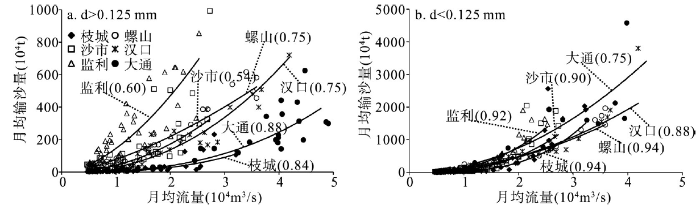
以幂函数曲线拟合三峡水库坝下游干流各水文站d > 0.125 mm输沙量与月均流量关系(图6a),分析表明:枝城至监利河段d > 0.125 mm输沙量随流量增加逐渐恢复,且沿程上为增加趋势,且流量越大恢复程度越高。监利至汉口河段受洞庭湖入汇影响,由于城陵矶站d > 0.125 mm输沙量很少,2003-2009年该粒径组泥沙输移量为25万t,其含沙量近乎于零。因此,在相同月均流量下,螺山站d > 0.125 mm输沙量低于监利站,汉口站d > 0.125 mm输沙量与流量关系与螺山站保持一致。汉口至大通河段,鄱阳湖入汇长江的泥沙主要为细颗粒部分,2009-2014年湖口站d > 0.125 mm悬沙总输沙量94.46万t(年均15.74万t),占大通站总输沙量比例几乎为零,由于鄱阳湖入汇长江使得大通站水量增加,该组分泥沙淤积,综合作用使得大通站小于汉口站。以幂函数曲线拟合坝下游水文站d < 0.125 mm输沙量与月均流量关系(图6b),分析表明:在相同流量下,枝城至监利河段该粒径组输沙量沿程上为增加趋势,说明该粒径组输沙量在各级流量下均有明显恢复;从各站点不同流量来看,随着流量增大d < 0.125 mm输沙量为增加趋势;监利至汉口河段,受洞庭湖汇流影响,螺山站d < 0.125 mm输沙量明显低于监利站;受汉江入汇影响,汉口站d < 0.125 mm输沙量绝大多数数据点位于螺山站下方;汉口至大通河段,受鄱阳湖汇流影响,入汇泥沙主要为d < 0.125 mm的细颗粒,湖口站含沙量低于汉口站,在河床补给和湖泊入汇等作用下使得大通站d < 0.125 mm输沙量高于汉口站。
2.4 三峡水库坝下游悬沙恢复与流量过程作用机制
由于长江中下游泥沙输移集中在汛期,且粗颗粒泥沙集中在大流量时期,进一步考察年内流量过程变化。长江中下游不同河段洪水流量存在一定差异,宜昌—监利河段选取Q ≥ 2.5×10⁴ m3/s,螺山站Q ≥ 3.0×10⁴ m3/s,汉口站Q ≥ 3.5×10⁴ m3/s,大通站Q ≥ 4.5×10⁴ m3/s作为洪水流量。坝下游2008-2014年大于某流量天数内的均值流量低于2003-2007年,使得洪水期输沙能力减弱,同时各站(除螺山站、大通站外)持续天数呈减少趋势,综合作用下使得2008-2014年d > 0.125 mm泥沙输移量低于2003-2007年(图7)。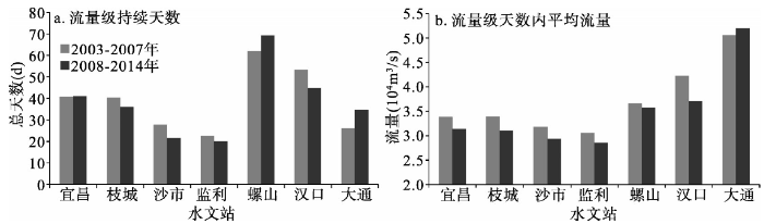 显示原图|下载原图ZIP|生成PPT
图72003-2014年三峡水库坝下游各水文站洪水流量及持续时间变化
-->Fig. 7Flow and duration variation of the floods at the hydrologic stations in the downstream of TGP during 2003-2014
-->
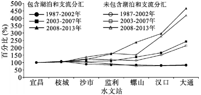
长江中下游d < 0.125 mm泥沙来源主要是上游流域、支流入汇和河床补给等。以宜昌站代表上游来沙量,1987-2002年,枝城站占宜昌站百分比增加,枝城以下无论是支流入汇还是湖泊分汇作用,d < 0.125 mm泥沙占宜昌站小于该粒径级泥沙百分比均减少(图8)。2003-2007年和2008-2014年两个时间段,d < 0.125 mm悬沙输移量变化规律为:宜昌至枝城河段略有增加,这与蓄水前1987-2002年规律是一致的;枝城至监利河段为恢复趋势,若无洞庭湖三口分流作用,该组泥沙恢复的程度将增大;监利至大通河段为沿程恢复趋势,2008-2014年恢复程度高于2003-2007年,由于宜昌站2008-2014年d < 0.125 mm泥沙量大幅减少,虽然长江中下游悬沙恢复程度大,干流区间河床冲刷补给对悬沙恢复起到一定积极作用,但2008-2014年的年均输沙量仍低于2003-2007年。
 显示原图|下载原图ZIP|生成PPT
图81987-2014年三峡水库坝下游支流和湖泊分汇对干流d < 0.125 mm悬沙的补给过程
-->Fig. 8Suspended sediment (d < 0.125 mm) compensation from the tributaries and lakes in the downstream of TGP during 1987-2014
-->
3 三峡水库坝下游床沙补给机制研究
3.1 三峡水库坝下游床沙颗粒变化过程
图9绘制了三峡水库坝下游河床中值粒径变化过程,2003年、2007年和2010年为粗化趋势,宜昌至枝城河段粗化程度最大,枝城至螺山河段为普遍粗化,向下游粗化程度减弱,螺山站以下河段整体为粗化趋势,其粗化与细化交替发生。一般而言,河床粗化不利于d > 0.125 mm和d < 0.125 mm泥沙的恢复。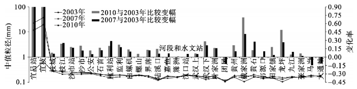 显示原图|下载原图ZIP|生成PPT
图92003年、2007年和2010年三峡水库坝下游河段床沙中值粒径变化
-->Fig. 9Median size variation of the bed sands in the downstream of TGP in 2003, 2007 and 2010
-->
3.2 三峡水库坝下游床沙补给过程研究
在三峡水库坝下游河床质组成上(图10),近坝段d < 0.125 mm组分为减少趋势,宜昌至枝城河段甚至近于零,表明这一河段河床中d < 0.125 mm床沙对悬沙的补给作用减弱,甚至出现不再补给悬沙的现象,使得本河段d < 0.125 mm悬沙输移量呈减少趋势,且不能恢复至蓄水前均值。枝城以下河段床沙中d < 0.125 mm百分比虽存在减小趋势,但比例基本在10%以上,对悬沙仍起到补给作用。因此,蓄水后坝下游床沙中d < 0.125 mm的百分比减小,若上游来沙量持续处于较低水平,坝下游d < 0.125 mm悬沙输沙量沿程上虽得到一定恢复,但输沙量难以恢复至蓄水前均值。d > 0.125 mm百分比为增大趋势,该组分泥沙对悬沙起到补给作用取决于洪水持续时间和流量,三峡水库蓄水后坝下游洪水持续时间和流量均为减少趋势,表明对该组分泥沙的补给动力减弱,其输沙量将进一步减少。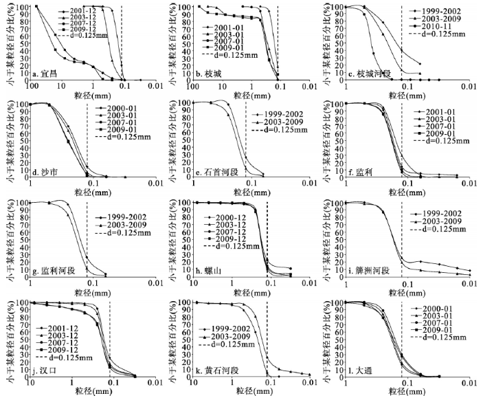 显示原图|下载原图ZIP|生成PPT
图10三峡水库坝下游河床表层床沙质百分比变化
-->Fig. 10Surface bed load variations in in the downstream of TGP
-->
 显示原图|下载原图ZIP|生成PPT
图11长江中游河床地质组成
-->Fig. 11Geological composition of the river bed in the middle reaches of the Yangtze River
-->
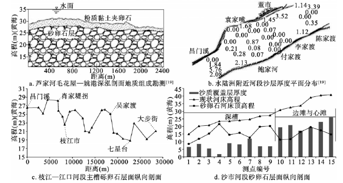
由于水流处于不饱和状态,河床表层床沙逐渐冲刷补给悬沙,但补给量和强度除受制于水动力强弱和河床组成,其补给量还受制于河床可冲层厚度。宜昌至枝城为砂卵石河段,从图11可以看出,该河段河床上d < 0.125 mm组分基本为零,2009年测次显示,床沙中0.125 mm < d < 0.50 mm组分冲刷殆尽。宜昌至枝城河段床沙对悬沙细颗粒补给量极小,粗颗粒泥沙虽存在补给,但河道深槽的补给已基本完成。图11c为砂卵石向沙质河段过渡区域沙质和砂卵石覆盖层变化,枝城至昌门溪河段为砂卵石向沙质的过渡段,芦家河处于砂卵石河段末端,蓄水前河床表层可冲层厚度较小,下层存在大量砂卵石,随着河道冲刷的持续,下层砂卵石层对粗颗粒泥沙补给减少。水陆洲附近可冲层厚度在深槽出现为零的情况,岸滩冲刷层仍较厚。枝城至芦家河河段,d > 0.125 mm和d < 0.125 mm的悬沙均得到恢复,蓄水后荆江河段崩岸频繁[20],进一步说明补给泥沙来自岸滩变形或是崩退。枝江至江口河段主槽砂卵石覆盖层顶高程逐渐减小,可冲层厚度逐渐增加,近年来该河段深泓下切,卵石层上的沙质层逐渐减小,对悬沙的补给量也将不足。沙市河段沙质冲刷层厚度深槽小于10 m,边滩和心滩沙质覆盖层仍较厚,即在沙质河段粗颗粒泥沙的补给仍较为充足。
3.3 三峡大坝下游河床调整与悬沙恢复和床沙补给关系分析
三峡水库坝下游宜昌至大通河段可划分为宜昌至枝城、上荆江(枝城至藕池口)、下荆江(藕池口至城陵矶)、城陵矶至汉口、汉口至湖口和湖口至大通河段。整理上述河段平滩河槽单位河长冲淤强度数据(图12),主要分析如下:(1)宜昌至枝城河段,1987-2002年、2003-2007年和2008-2014年均为冲刷,冲刷强度蓄水后高于蓄水前,2008-2014年弱于2003-2007年。主要原因是砂卵石河段床沙大幅粗化,河床中d < 0.125 mm泥沙组分近乎为零,对该组分悬沙的补给严重不足;同时洪水流量持续天数和流量均值减少,对河床上d > 0.125 mm泥沙的冲刷能力减弱,使得床沙对该组分悬沙补给作用减弱,也是原因之一。
 显示原图|下载原图ZIP|生成PPT
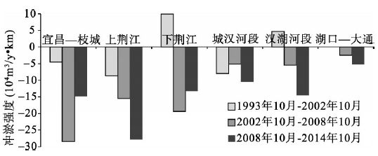
图12三峡水库坝下游河段冲淤强度变化
-->Fig. 12Erosion and deposition intensity variation in the downstream of TGP
-->
(2)上荆江河段,位于枝城站和监利站区间,上荆江河床冲刷强度为增大趋势,这一河段d > 0.125 mm悬沙逐渐恢复,由于洞庭湖分汇流对该组分悬沙的恢复影响较小,即这一河段d > 0.125 mm输沙量的增加主要来自于河床冲刷补给。d < 0.125 mm泥沙逐渐得到恢复,说明上荆江河段河床泥沙为粗细均冲,即为三峡水库蓄水后冲刷较大且集中的区段。
(3)下荆江河段,位于监利站和螺山站区间,d > 0.125 mm悬沙恢复程度减弱,1987-2002年、2003-2007年和2008-2014年螺山站d > 0.125 mm输沙量均低于监利站,3个时段d > 0.125 mm泥沙均为淤积,说明当d > 0.125 mm泥沙恢复至蓄水前相近水平后,其下游河段该组泥沙的冲淤特性与蓄水前相一致。河段之间存在洞庭湖入汇,1987-2002年、2003-2007年和2008-2014年螺山站—城陵矶站—监利站d < 0.125 mm量值差分别为-0.268亿t/y、0.015亿t/y和0.006亿t/y,即蓄水前为淤积趋势,蓄水后为冲刷趋势。下荆江河段泥沙冲淤在1987-2002年为粗细均淤积,2003-2007年和2008-2014年为淤粗冲细,由于监利站洪水流量持续天数和流量均值减少,同时河床粗化使得细颗粒泥沙补给不足,综合作用使得2008-2014年下荆江河段冲刷强度较2003-2007年有所减弱。
(4)城陵矶至汉口河段,位于螺山站和汉口站区间,1987-2002年、2003-2007年和2008-2014年河床均为冲刷趋势。悬沙中d > 0.125 mm泥沙1987-2002年为冲刷趋势,2003-2007年为淤积趋势,2008-2014年为冲刷趋势。2008-2013年螺山站Q > 35000 m3/s流量持续时间和量值较2003-2007年增加,使得两时期冲淤性质发生变化。这一点认识与以往研究认识不一致,主要是以往研究中资料限于2007年以前[10],或是将蓄水后2003-2011年作为整体[11],一定程度上掩盖了洪水流量对其影响。考虑汉江入汇,其中汉江入汇口在汉口站以上1.15 km,依据输沙量法计算计算城陵矶至汉口河段冲淤关系,汉口站需扣除汉江入汇长江皇庄站沙量。1987-2002年、2003-2007年和2008-2014年汉口—汉江皇庄—螺山站d < 0.125 mm量值差分别为-0.189亿t/y、0.089亿t/y和0.124亿t/y,蓄水前为淤积趋势,蓄水后为冲刷趋势。城陵矶至武汉河段泥沙冲淤特性为蓄水前1987-2002年冲粗淤细,2003-2007年为淤粗冲细,2008-2014年为粗细均冲,引起蓄水后2003-2007年和2008-2014年粗细颗粒泥沙冲淤规律的改变,主要是洞庭湖和长江干线流量共同作用下,螺山站洪水流量持续天数增加,但均值流量略有减少,综合条件下洪水持续天数内的总水量为增加趋势,增加了冲刷动力,使得泥沙冲淤规律由2003-2007年的“淤粗冲细”转变为2008-2014年的“粗细均冲”。由于螺山站洪水水量的增加,因城陵矶至汉口河段为沙质河床,河床泥沙补给量充足,出现2008-2014年冲刷强度高于2003-2007年的现象。
(5)汉口至大通河段,位于汉口站和大通站区间,1987-2002年为淤积趋势,但幅度有限,2008-2014年冲刷强度高于2003-2007年。由于鄱阳湖入江泥沙主要为细颗粒悬沙,汉口至大通区间d > 0.125 mm泥沙冲淤不考虑鄱阳湖入汇的影响。大通站—湖口站—汉口站d > 0.125 mm悬沙1987-2002年、2003-2007年和2008-2014年量值差分别为 +0.01亿t/y、-0.18亿t/y和-0.07亿t/y,蓄水前为微冲趋势,蓄水后为淤积趋势。对于d > 0.125 mm悬沙蓄水前后冲淤性质的转变,已有研究认为蓄水后d > 0.125 mm泥沙淤积为区间径流量较蓄水前减少所致[10]。大通站—湖口站—汉口站d < 0.125 mm输沙量在1987-2002年、2003-2007年和2008-2014年的量值差分别为-0.013 t/y、0.295 t/y和0.312亿t/y,表明蓄水前为微淤趋势,蓄水后为冲刷趋势。总体上,蓄水前汉口至大通河段泥沙冲淤较小,处于相对平衡状态,蓄水后为冲刷趋势。依据输沙量平衡方法计算汉口至大通河段冲淤强度,结果表明,1987-2002年、2003-2007年和2008-2014年平均冲淤量分别为-0.006亿t/y、0.12亿t/y和0.21亿t/y,2008-2014年冲刷量高于2003-2007年,与河道冲刷强度相对应。汉口至湖口河段和湖口至大通河段河床冲刷强度存在一定差异,在汉口至湖口河段沿程上细颗粒泥沙冲刷得到一定恢复,在湖口以下由于鄱阳湖入汇一部分细颗粒泥沙,湖口至大通河段不饱和水体含沙量增大,使得对河床冲刷强度减弱,综合作用下湖口—大通河段在冲淤强度上弱于汉口至湖口河段。
分析可知,宜昌至大通区间各河段的泥沙冲淤量与河床冲淤强度对应关系较好,结合蓄水后洪水流量持续时间和量值,解释了蓄水后2003-2007年和2008-2014年冲淤的差异性。但是在泥沙冲淤和河床冲淤量值上的差异较大,原因可能为河道采砂和航道疏浚等综合作用所致。河道采砂在一定程度上加剧河床冲刷、拓宽及河道比降的调整,采砂作业“去粗留细”会促进床沙粗化进程[21]。整理长江干线2004-2011年中下游河道采砂数据(表2),可以发现,采砂占较大比重,如2009年采砂量占大通站年总输沙量的63.2%,并且采砂并非全部集中在平滩河槽以下,这一比例会有所减小。同时长江中下游航道管理与维护部门进行了大量疏浚,在不利年份疏浚量仍较大(表3)。在采砂和疏浚作用下,使得地形法和输沙量法计算得到河床冲淤强度数值不一致,甚至出现结果相差较大情况。
Tab. 2
表2
表22004-2011年长江中下游年度采砂控制量[
Tab. 2Annual sand mining controlled amounts in the middle and lower reaches of the Yangtze River during 2004-2011
| 年份 | 2004 | 2005 | 2006 | 2007 | 2008 | 2009 | 2010 | 2011 |
|---|---|---|---|---|---|---|---|---|
| 采砂控制量(万t) | 1186 | 1602 | 1240 | 1690 | 5140 | 7020 | 4430 | 4407 |
新窗口打开
Tab. 3
表3
表32008-2013年宜昌至大通河段疏浚量[
Tab. 3Dredging amounts in the Yichang-Datong section during 2008-2013
| 年份 | 2008 | 2009 | 2010 | 2011 | 2012 | 2013 |
|---|---|---|---|---|---|---|
| 疏浚量(万m3) | 25.9 | 69.9 | 51.5 | 466.7 | 147.5 | 608.9 |
新窗口打开
3.4 三峡水库及梯级水库运行后长江中下游泥沙输移趋势探讨
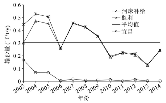
三峡水库拦截大量泥沙,清水下泄使得坝下游水体长期处于不饱和状态,由于悬沙输沙量沿程得到恢复,将使得坝下游河段长期处于冲刷状态。宜昌至枝城河段河床中细颗粒泥沙已冲刷殆尽,粗颗粒尤其是卵石由于洪水流量的削减,输移强度减弱,同时上层卵石对下层河床起到了隐蔽作用,增强了河床的抗冲刷能力。但若遭遇大洪水或特大洪水年份,对粗颗粒泥沙起到搬运作用,使得水流对河床的冲刷强度增加,但粗颗粒泥沙的输移距离十分有限。沙质河段河床中d > 0.125 mm粗颗粒泥沙大量存在,而d < 0.125 mm泥沙数量有限,使得沙质河段细颗粒悬沙输沙量恢复有限。虽然d > 0.125 mm悬沙输沙量恢复速度较快,但2008-2013年较2003-2007年恢复程度有所减弱,2003-2007年冲刷最大区域在上荆江河段,2008-2014年已向下游推进,初步判断冲刷影响已影响至下荆江河段。在长江上游一系列梯级水库的相继运用后,会进一步加剧清水下泄程度,随着时间的推移,冲刷重点区域也将下移。由于沙质河段d > 0.125 mm泥沙大量存在,悬沙中d > 0.125 mm的输沙量仍将逐渐恢复,但由于流量调平,尤其是洪水持续时间和总量的相对减少,使得该组泥沙输移量减少。依据近期规划,三峡水库将可能实行中小洪水调度,进一步增加流量调平幅度[24]。由于d > 0.125 mm的悬沙在监利站、螺山站和汉口站均得到了较大程度的恢复,但量值上监利站最大,选取监利站为代表水文站,预估三峡水库及上游梯级水库联合运用后坝下游粗颗粒泥沙输移量。2003-2014年监利站d > 0.125 mm泥沙最大输移量为0.53亿t/y,与宜昌站和三口差值代表宜昌至监利河段的河床补给量,补给量最大值为0.44亿t/y,均值为0.30亿t/y(图13)。综上,在三峡水库及上游梯级水库运用后,三峡水库实行中小洪水调度规则[24]、河床粗化等因素的综合作用下,长江中下游水文站d > 0.125 mm悬沙最大输移量不超过0.53亿t/y,由于河床上d > 0.125 mm床沙质大幅减少,河床补给量不超过0.44亿t/y(2003-2007年均值)。
 显示原图|下载原图ZIP|生成PPT
图132003-2014年宜昌至监利河段d > 0.125 mm泥沙变化
-->Fig. 13Sediment (d > 0.125 mm) variations in Yichang River during 2003-2014
-->
4 结论
由于三峡水库蓄水的作用,对坝下游水沙输移的影响已初步显现,本文利用1987-2014年长江中下游实测数据,揭示坝下游悬沙恢复和床沙补给机制,主要结论如下:(1)三峡水库蓄水后,坝下游洪水流量和持续时间被大幅削减,下泄泥沙近乎清水下泄,输沙量在沿程上逐渐恢复,但总量仍未超过蓄水前多年均值。
(2)2003-2014年三峡水库坝下游d > 0.125 mm悬沙量得到一定恢复,至监利站恢复程度最大,基本恢复至蓄水前均值水平,在恢复后其下游该组分泥沙冲淤特性与蓄水前一致,其中2008-2014年恢复程度弱于2003-2007年。
(3)2003-2007年和2008-2014年三峡水库坝下游悬沙中d < 0.125 mm输沙量得到一定恢复,2008-2014年恢复程度弱于2003-2007年,但总量不会超过蓄水前均值。
(4)三峡水库蓄水后d > 0.125 mm泥沙恢复主要为河床冲刷补给,但补给量将不超过0.44亿t/y,其补给量受制于洪水持续时间及流量均值,上游干流、河段间支流和湖泊分汇作用占次要地位,d < 0.125 mm悬沙恢复受上游干流、区间支流和湖泊分汇及河床补给控制,由于河床粗化影响使其对悬沙补给作用减弱。
(5)三峡水库蓄水后d > 0.125 mm和d < 0.125 mm泥沙的冲淤特性在不同河段存在差异,2003-2007年和2008-2014年两时段宜昌至枝城、上荆江为粗细均冲,下荆江为淤粗冲细,2003-2007年城陵矶至汉口河段为淤粗冲细,2008-2014年城陵矶至汉口河段为粗细均冲,这一差异受控于螺山站洪水流量持续时间和量值,汉口至大通河段为淤粗冲细。
The authors have declared that no competing interests exist.
参考文献 原文顺序
文献年度倒序
文中引用次数倒序
被引期刊影响因子
| [1] | Windamere Dam is located on the Cudgegong River near Mudgee, Australia, and was built for irrigation and town water supply. It is operated in a similar manner to the other large irrigation dams in New South Wales. The response of the Cudgegong River to flow regulation since dam closure in February 1984 was determined for 13 km of river downstream of the dam where the channel is a bedrock-confined gravel-bed stream. Mean daily flows for durations less than 70 per cent have been reduced by between 20 and 73 per cent and those for durations greater than 70 per cent have been increased by between 58 and 496 per cent. The dam has reduced downstream flood magnitudes for all recurrence intervals by between 57 and 72 per cent. The dam's sediment trap efficiency is estimated at greater than 95 per cent of the incoming sediment load. Complex river response was induced by flow regulation, and included simultaneous channel contraction, degradation, aggradation, accommodation adjustment, formation of tributary-mouth bars and in-channel benches, and massive vegetation encroachment at different locations. Mean bed-material size decreased at all aggrading sites. Regulated flows are incompetent for the transport of the bed material but large floods generated in unregulated tributaries below the dam exceed the threshold of motion at channel constrictions. These unregulated tributaries now supply the majority of sediment to the channel. This material is reworked by dam releases which preferentially remove the fines and deposit them in downstream pools and on in-channel benches. Vegetation has invaded these recent deposits. |
| [2] | ABSTRACT This study describes changes in mean channel-bed elevation, channel width, bed-material sizes, vegetation, water discharges, and sediment loads downstream from 21 dams constructed on alluvial rivers. Most of the studied channels are in the semiarid western US. Flood peaks generally were decreased by the dams, but in other respects the post-dam water-discharge characteristics varied from river to river. Sediment concentrations and suspended loads were decreased markedly for hundreds of kilometers downstream from dams; post-dam annual sediment loads on some rivers did not equal pre-dam loads anywhere downstream from a dam. Bed degradation varied from negligible to about 7.5 meters in the 287 cross sections studied. In general, most degradation occurred during the first decade or two after dam closure. Bed material initially coarsened as degradation proceeded, but this pattern may change during later years. Channel width can increase, decrease, or remain constant in the reach downstream from a dam. Despite major variation, changes at a cross section in stream bed elevation and in channel width with time often can be described by simple hyperbolic equations. Equation coefficients need to be determined empirically. Riparian vegetation commonly increased in the reach downstream from the dams, probably because of the decrease in peak flows. 120 references, 49 figures, 14 tables. |
| [3] | |
| [4] | . 正1 前言三门峡水库的建成和运用,改变了下游河道的来水来沙条件,泥沙的输移和凋整也出现了新的特色。数十年来.就水沙的组合来看,三门峡水库的运用及其造成的典型的水沙条件可分为:①水库蓄水拦沙,持续下泄清水。②库水位急剧下降,水库集中排沙。③“蓄清排浑”期非汛期下泄清水。④“蓄清排浑”期汛初水库冲刷排沙。本文选取上述典型时段流量比较平稳,沿程变化不大的过程作为研究时段。对上述四 . 正1 前言三门峡水库的建成和运用,改变了下游河道的来水来沙条件,泥沙的输移和凋整也出现了新的特色。数十年来.就水沙的组合来看,三门峡水库的运用及其造成的典型的水沙条件可分为:①水库蓄水拦沙,持续下泄清水。②库水位急剧下降,水库集中排沙。③“蓄清排浑”期非汛期下泄清水。④“蓄清排浑”期汛初水库冲刷排沙。本文选取上述典型时段流量比较平稳,沿程变化不大的过程作为研究时段。对上述四 |
| [5] | Based on data from river gauging stations, the multi-year variations in suspended sediment flux (SSF) from China's nine major rivers to the sea were examined. The decadal SSF decreased by 70.2%: from 1.81 Gt/year for 1954–1963 to 0.54 Gt/year for 1996–2005. The decrease in SSF was more dramatic in the arid northern region than in the wet southern region; from north to south, the SSF decreased by 84% in the Yellow River, 42% in the Yangtze River, and 22% in the Pearl River. Dam construction was the principal cause for the decrease in SSF. At present, approximately 2 Gt/year of sediment is trapped in the reservoirs within the nine river basins. Reduced precipitation and increased water extraction and sand mining have also played a role in the decrease in SSF. Although water and sediment conservation programmes have not counteracted the influence of deforestation, they have enhanced the decrease in SSF in recent years. It is concluded that human activity has become a governing factor on riverine sediment delivery to the sea in China. |
| [6] | Not Available |
| [7] | 在河口,人的活动的影响和河口规定基于推迟的沉积元素的分析混浊最大值地区上的工程根据在 1959 和 2011 之间的测量数据被学习。当在流量的沉积体积和集中的锋利的减少在河口导致了混浊最大值地区的锋利的减少时,人的活动在朝海的方向水上有小效果,这被发现当在流量的沉积体积和集中的锋利的减少在河口导致了混浊最大值地区的锋利的减少时。集中在外面,海和 Hangzhou 海湾没变化,并且那也有点沿着 Subei 海岸减少,它没在混浊最大值地区上有影响。与在 1959 和 1999 之间的集中相比,在河口在上游的移动的集中的山峰,和在 20002009 的集中沿着河与一个更狭窄的变化范围在大约 24.73% 减少了到海。在诺思经过的推迟的沉积集中是低的在因为朝海的方向沉积的减少在上游、下游、床材料变粗,当它由于沉积的影响在中间相对高时,穿过北方突堤。 |
| [8] | The sediment discharge from the Yangtze River Basin has a stepwise decreasing trend in recent years.The impounding of the Three Gorges Reservoir exacerbated this decreasing trend and affected the change of the suspended sediment concentration(SSC) in the Yangtze River Estuary through the transmission effect.The SSC data of the Yangtze River Estuary during 1959-2012 showed that:(1) The SSC in the South Branch of the Yangtze River in the estuary and in the off-shore sea area displayed decreasing trends and decreased less towards the sea.At the same time,the difference in decreasing magnitude between SSC and sediment discharge became bigger towards the sea;(2) For the North Branch the preferential flow did not change much but the SSC tended to decrease,which was mainly caused by the decrease of SSC in the south branch and East China Sea;(3) Due to the decreased runoff and the relatively strengthened tide,the peak area of the SSC in the bar shoal section in 2003-2012 moved inward for about 1/6 longitude unit compared with that in1984-2002,and the inward-moving distance was in the order of flood season annual average dry season;(4) In the inlet of the South Passage,the SSC decreased mainly because the increase caused by resuspension and shore-groove exchange was less than the decrease caused by the sharp SSC decrease in the basin and the sea areas.The reverse was true in the middle section,where the SSC showed an increasing trend.(5) In the inlet of the North Passage,under the combined influence of decreased flow split and sediment split ratios,decreased SSC in the basin and the sea area and decreased amount of resuspension,the SSC displayed a decreasing trend.In the middle section,because the increased amount caused by sediment going over the dyke was more significant than the decreased amount caused by external environments,the SSC tended to increase.Holistically,the sharp decrease in sediment discharge caused synchronized SSC decreases in the Yangtze River Estuary.But there were still areas where the SSC displayed increasing trends,indicating synchronicity and difference in the response of SSC to the sharp decrease in sediment discharge from the basin. |
| [9] | 回顾和分析了三峡建库前后坝下游汉口以上河段的冲淤情况.通过分析丹江口、三门峡等水库下游实测资料表明,在水库下游河床冲刷、沙量恢复过程中,各粒径组输沙量均不会超出建库前水平,这是与河床边界、河型等因素无关的一般性规律.目前三峡水库下游冲淤计算成果与其他水库下游的冲淤规律存在矛盾之处,汉口以上河段冲淤情况以及对防洪的影响值得商榷. . 回顾和分析了三峡建库前后坝下游汉口以上河段的冲淤情况.通过分析丹江口、三门峡等水库下游实测资料表明,在水库下游河床冲刷、沙量恢复过程中,各粒径组输沙量均不会超出建库前水平,这是与河床边界、河型等因素无关的一般性规律.目前三峡水库下游冲淤计算成果与其他水库下游的冲淤规律存在矛盾之处,汉口以上河段冲淤情况以及对防洪的影响值得商榷. |
| [10] | 水库修建前后下游河道分组沙冲淤实测资料表明:建库前特定河段粗沙淤积主要是由于水力因素沿 程显著减弱; 建库后近坝河段,泥沙补给不足,各组泥沙均发生较剧烈的冲刷,床沙粗化迅速; 距坝较远的河段,只要上游河段有足够泥沙补给,能够基本达到饱和的各组泥沙的冲淤特性与建库前保持一致,但淤积量趋于减小; 水库下游发生长距离冲刷的主要原因是床沙补给不足,尤其是细沙补给严重不足。 . 水库修建前后下游河道分组沙冲淤实测资料表明:建库前特定河段粗沙淤积主要是由于水力因素沿 程显著减弱; 建库后近坝河段,泥沙补给不足,各组泥沙均发生较剧烈的冲刷,床沙粗化迅速; 距坝较远的河段,只要上游河段有足够泥沙补给,能够基本达到饱和的各组泥沙的冲淤特性与建库前保持一致,但淤积量趋于减小; 水库下游发生长距离冲刷的主要原因是床沙补给不足,尤其是细沙补给严重不足。 |
| [11] | 三峡工程蓄水后“清水”下泄,长江中游含沙量将会长期处于严重不 饱和状态,水流含沙量沿程恢复将会引起长江中游长距离冲刷,本文根据三峡工程蓄水以来的实测资料分析长江中游泥沙输移变化规律,得到以下结论:在“清水” 冲刷下荆江三口分流分沙比无明显变化趋势,江湖水沙分配对长江中游含沙量恢复影响较小;其中d <0.125mm粒径沙量在长江中游沿程缓慢恢复且恢复程度远小于蓄水前,这是坝下游河段发生长距离冲刷的根本原因;而d>0.125mm粒径沙量在宜昌 -监利河段恢复速率较快,且在监利站附近该粒径含沙量基本恢复饱和,这也造成冲刷重点集中在荆江河段. . 三峡工程蓄水后“清水”下泄,长江中游含沙量将会长期处于严重不 饱和状态,水流含沙量沿程恢复将会引起长江中游长距离冲刷,本文根据三峡工程蓄水以来的实测资料分析长江中游泥沙输移变化规律,得到以下结论:在“清水” 冲刷下荆江三口分流分沙比无明显变化趋势,江湖水沙分配对长江中游含沙量恢复影响较小;其中d <0.125mm粒径沙量在长江中游沿程缓慢恢复且恢复程度远小于蓄水前,这是坝下游河段发生长距离冲刷的根本原因;而d>0.125mm粒径沙量在宜昌 -监利河段恢复速率较快,且在监利站附近该粒径含沙量基本恢复饱和,这也造成冲刷重点集中在荆江河段. |
| [12] | The grain size of river sediments changes systematically downstream from source to sink, and is influenced by catchment lithology, geomorphology, hydrology, oceanography and, in modern settings, anthropogenic impacts. Compared with small, gravel-bedded river systems, less is known about large, sandy鈥恇ed rivers, particularly from the river source to marine sink. In the present study, we examine longitudinal changes in sediment grain size along the middle and lower Yangtze River, downstream of the Three Gorges Dam (TGD), and along the major sediment dispersal pathway into the East China Sea, over a total length of 2100km. We also examine the spatial patterns of seabed sediment grain size in the East China Sea adjacent to the Yangtze Estuary (70,000km 2 in area). In particular, we consider the impact of the TGD on the grain size of the riverbed and seabed sediments. Before the construction of the TGD, the relationship between median grain size and distance along the sandy bed of the middle and lower Yangtze showed a downstream fining trend that was exponential in form. After the TGD was built, erosion caused an abrupt gravel鈥搒and transition to develop in the section immediately downstream of the TGD. In the Yangtze Estuary, flocculation and subsequent deposition of suspended riverine mud during the slack water period between flood and ebb tides led to the formation of an abrupt sand鈥搈ud transition. Muddy deposits along the major longshore sediment dispersal route also show an exponential fining trend. However, towards the open East China Sea, the modern riverine muds are replaced seawards by older sands. The mud margin there was found to have retreated landward significantly over the post-TGD period due to erosion driven by the significant decrease in sediment supply from the Yangtze River. We expect that the impact of the TGD on the grain size of bed sediments in the Yangtze River and the East China Sea will continue for some time, and the change in the grain size of bed sediments there will become more pronounced. |
| [13] | The sediment regime of the Yangtze River (Changjiang) has been altered by intensified human activities over the past decades, particularly dam construction. To investigate the impacts of dam building on the sediment regime in the Yangtze River, two of the largest reservoirs on the upper reach, i.e. the Gezhouba reservoir and the Three Gorges reservoir, have been selected as case study sites. To analyze the changes in sediment regime between pre-dam and post-dam periods, the whole study period was divided into three sub-periods according to the years when these two reservoirs started to store water. On the basis of the time series of daily water discharge and sediment concentration from four key hydrological stations, i.e. Cuntan, Yichang, Hankou and Datong, the alterations of annual, seasonal, monthly and daily sediment regimes in different sub-periods were investigated and the driving forces were explored. The results revealed: the impacts varied with reservoir storage capacity, operation modes and the distance between the target reservoir and the case study site; Sediment trapping in reservoirs together with soil and water conservation measures was of significant impacts on different time scales of sediment regimes. The results of the study could provide references for the assessment of impacts of dam construction on the health and stability of the Yangtze River ecosystem. |
| [14] | 定量评价三峡蓄水后长江中游流 域水文情势的时空变化,为长江中游生态保护和区域水资源管理提供科学依据。采用变化范围法分析了长江干流5个水文站的流量、含沙量日均数据,定量评估了三 峡工程蓄水后,长江中游水沙变化度最大的江段和水文指标类别,及其对应的生态影响。研究结果表明三峡蓄水后,下游河道含沙量的变化度远大于流量,除城陵矶 站外,含沙量较蓄水前有了大幅度下降,宜昌站的含沙量下降幅度达到了一个数量级,洞庭湖对长江干流含沙量有明显的调蓄作用。流量的变化度随着与大坝距离的 增加而减小,且在7~11月流量下降幅度明显。这些水文节律的变化将影响下游鱼类产卵栖息地以及滞洪区水生生物与周边植被的生长。 . 定量评价三峡蓄水后长江中游流 域水文情势的时空变化,为长江中游生态保护和区域水资源管理提供科学依据。采用变化范围法分析了长江干流5个水文站的流量、含沙量日均数据,定量评估了三 峡工程蓄水后,长江中游水沙变化度最大的江段和水文指标类别,及其对应的生态影响。研究结果表明三峡蓄水后,下游河道含沙量的变化度远大于流量,除城陵矶 站外,含沙量较蓄水前有了大幅度下降,宜昌站的含沙量下降幅度达到了一个数量级,洞庭湖对长江干流含沙量有明显的调蓄作用。流量的变化度随着与大坝距离的 增加而减小,且在7~11月流量下降幅度明显。这些水文节律的变化将影响下游鱼类产卵栖息地以及滞洪区水生生物与周边植被的生长。 |
| [15] | The increasing impact of both climatic change and human activities on global river systems necessitates an increasing need to identify and quantify the various drivers and their impacts on fluvial water and sediment discharge. Here we show that mean Yangtze River water discharge of the first decade after the closing of the Three Gorges Dam (TGD) (2003–2012) was 6765km/yr (7%) lower than that of the previous 50 years (1950–2002), and 12665km/yr less compared to the relatively wet period of pre-TGD decade (1993–2002). Most (60–70%) of the decline can be attributed to decreased precipitation, the remainder resulting from construction of reservoirs, improved water-soil conservation and increased water consumption. Mean sediment flux decreased by 71% between 1950–1968 and the post-TGD decade, about half of which occurred prior to the pre-TGD decade. Approximately 30% of the total decline and 65% of the decline since 2003 can be attributed to the TGD, 5% and 14% of these declines to precipitation change, and the remaining to other dams and soil conservation within the drainage basin. These findings highlight the degree to which changes in riverine water and sediment discharge can be related with multiple environmental and anthropogenic factors. |
| [16] | |
| [17] | In 2006, the suspended sediment discharge (SSD) into the Yangtze (Changjiang) Estuary, China, reached the historical low value of 8565×6510t. One hypothesis is that this was caused by the second impoundment, i.e. the second stage of the water-level increase behind the Three Gorges Dam (TGD). However, coincidentally, a significant drought occurred in the same year. From our analysis of long-term data on discharge and SSD, we conclude that the SSD decrease in the upstream catchment area resulting from the extreme drought is primarily responsible for the historical low SSD into the Yangtze Estuary. We quantified the contributions of the extreme drought and the second impoundment to the reduction of SSD into the Yangtze Estuary in 2006 as 82% and 18%, respectively. Even though the TGD is the largest dam in the world, the results indicate that the extreme drought conditions had a greater impact than such a manmade river regulation.Dai, Z. J., Chu, A., Stive, M, Du, J. Z. & Li, J. F. (2011) Is the Three Gorges Dam the cause behind the extremely low suspended sediment discharge into the Yangtze (Changjiang) Estuary of 2006? (7), 1280–1288. |
| [18] | |
| [19] | 通过30余年特别是三峡水库蓄 水以来水文、地形、地质等实测资料的系统收集,对长江中游枝城-陈家湾河段的沙卵石-沙质河床过渡带冲刷特性和发展趋势开展分析。结果表明:虽然河段内自 上而下呈现出卵石逐渐减少而沙质比例逐渐增多的渐变特点,但以昌门溪-马家店一带为界,上下游的洲滩组成、深泓形态、河床冲淤、水位下降等方面存在突变现 象。在三峡水库蓄水后的冲刷过程中,虽然全河段内均出现了汊道冲刷、枯期河槽扩大的现象,但可以预计的是,河段内河势不会发生大的变化,而昌门溪以下河段 难以抵御水位下降的溯源传递,马家店以上在枯水期将出现比现状更为严重的坡陡、流急、水浅现象。 . 通过30余年特别是三峡水库蓄 水以来水文、地形、地质等实测资料的系统收集,对长江中游枝城-陈家湾河段的沙卵石-沙质河床过渡带冲刷特性和发展趋势开展分析。结果表明:虽然河段内自 上而下呈现出卵石逐渐减少而沙质比例逐渐增多的渐变特点,但以昌门溪-马家店一带为界,上下游的洲滩组成、深泓形态、河床冲淤、水位下降等方面存在突变现 象。在三峡水库蓄水后的冲刷过程中,虽然全河段内均出现了汊道冲刷、枯期河槽扩大的现象,但可以预计的是,河段内河势不会发生大的变化,而昌门溪以下河段 难以抵御水位下降的溯源传递,马家店以上在枯水期将出现比现状更为严重的坡陡、流急、水浅现象。 |
| [20] | Bank erosion is a key process in a fluvial system in the context of river dynamics and geomorphology. Since the operation of the Three Gorges Project (TGP), the Lower Jingjiang Reach (LJR) below the dam has experienced continuous channel degradation, with the phenomenon of bank erosion occurring frequently in local reaches. Therefore it is necessary to quantitatively investigate seasonal variations in the stability of composite riverbanks along the reach in order to better understand the fluvial processes in the reach. Laboratory tests were conducted for the sampled soils at six riverbanks during a field survey, with various bank soil properties being presented for the first time. These test results show that: the cohesive bank soils are relatively loose due to the high water contents of 28.5-40.0% and the low dry densities of 1.31-1.47 tonnes/m |
| [21] | 水库与河道采砂共同作用下的河道有其独特的演变进程。以闽江下游河道为例,对水库及河道采砂作用下的河道演变情况进行初步分析,探讨了两者联动作用下的河道演变特征。结果表明:在水库清水下泄及河道采砂共同作用下,闽江下游河床的演变主要表现为河床纵横向的大幅度下切,河道断面面积显著扩大,河床泥沙损失量极大。在采砂得到禁止的北港,河床则较为稳定,冲淤幅度小。水库与河道采砂引发的河床演变均是使河床形态朝着与水沙条件相适应的平衡状态发展,两者作用下的河道演变呈现出3个特征:河道冲刷加剧,河床下切幅度明显;河床演变规律复杂,演变趋势难以准确预测;演变带来的不利影响非常严重。 . 水库与河道采砂共同作用下的河道有其独特的演变进程。以闽江下游河道为例,对水库及河道采砂作用下的河道演变情况进行初步分析,探讨了两者联动作用下的河道演变特征。结果表明:在水库清水下泄及河道采砂共同作用下,闽江下游河床的演变主要表现为河床纵横向的大幅度下切,河道断面面积显著扩大,河床泥沙损失量极大。在采砂得到禁止的北港,河床则较为稳定,冲淤幅度小。水库与河道采砂引发的河床演变均是使河床形态朝着与水沙条件相适应的平衡状态发展,两者作用下的河道演变呈现出3个特征:河道冲刷加剧,河床下切幅度明显;河床演变规律复杂,演变趋势难以准确预测;演变带来的不利影响非常严重。 |
| [22] | 流域人类活动对长江中下游水沙态势变异产生重要影响,为了深入了 解长江中下游水沙态势变异特征及主要影响因素,本文利用累积曲线法、M-K次序分析法和有序聚类法就长江中下游干流、主要支流和两湖(洞庭湖、鄱阳湖)湖 口1950-2011年期间水沙态势变化特征进行研究,分析了流域人类活动的变化特征,指出长江中下游干流汉口站和大通站、主要支流汉江皇庄站及鄱阳湖湖 口站年径流量没有明显的变化趋势,干流宜昌站和洞庭湖湖口城陵矶站的年径流量有显著减少的趋势;除鄱阳湖湖口站年输沙量变化不大外,干流、主要支流和洞庭 湖水文站年输沙量显著减少.结合长江中下游水沙变化的特征,分析了水库拦沙、水土保持、两湖(洞庭湖、鄱阳湖)区域水沙变化、河道采砂等因素的影响,指出 不同的影响因子对河道水沙态势变化的作用是不同的,特别是水库拦沙的影响更显著,三峡水库运用对中下游干流水沙态势变异的作用是非常重要的. 流域人类活动对长江中下游水沙态势变异产生重要影响,为了深入了 解长江中下游水沙态势变异特征及主要影响因素,本文利用累积曲线法、M-K次序分析法和有序聚类法就长江中下游干流、主要支流和两湖(洞庭湖、鄱阳湖)湖 口1950-2011年期间水沙态势变化特征进行研究,分析了流域人类活动的变化特征,指出长江中下游干流汉口站和大通站、主要支流汉江皇庄站及鄱阳湖湖 口站年径流量没有明显的变化趋势,干流宜昌站和洞庭湖湖口城陵矶站的年径流量有显著减少的趋势;除鄱阳湖湖口站年输沙量变化不大外,干流、主要支流和洞庭 湖水文站年输沙量显著减少.结合长江中下游水沙变化的特征,分析了水库拦沙、水土保持、两湖(洞庭湖、鄱阳湖)区域水沙变化、河道采砂等因素的影响,指出 不同的影响因子对河道水沙态势变化的作用是不同的,特别是水库拦沙的影响更显著,三峡水库运用对中下游干流水沙态势变异的作用是非常重要的. |
| [23] | . |
| [24] | 为科学调度运用防洪库容,合理利用洪水资源,在三峡工程正常蓄水位175 m试验性蓄水期间,实施了中小洪水滞洪调度和提前至汛末蓄水方案。分析了方案存在的防洪风险、泥沙游积风险以及对生态环境的不利影响。采取设定中小洪水滞洪调度启用条件,使防洪风险可控,相机适时控泄流量检验下游堤防抗洪能力以防止河道姜缩等对策,降低了防洪风险。在实施汛期沙峰(排沙)调度和汛前库尾减游调度时,试验得到了“蓄清排浑”运行新模式,减小了水库泥沙游积风险。提出应加强试验研究和跟踪监侧,探索减小生态环境不利影响的措施,为全面发挥三峡工程综合效益,降低各种风险提供了技术支撑。 . 为科学调度运用防洪库容,合理利用洪水资源,在三峡工程正常蓄水位175 m试验性蓄水期间,实施了中小洪水滞洪调度和提前至汛末蓄水方案。分析了方案存在的防洪风险、泥沙游积风险以及对生态环境的不利影响。采取设定中小洪水滞洪调度启用条件,使防洪风险可控,相机适时控泄流量检验下游堤防抗洪能力以防止河道姜缩等对策,降低了防洪风险。在实施汛期沙峰(排沙)调度和汛前库尾减游调度时,试验得到了“蓄清排浑”运行新模式,减小了水库泥沙游积风险。提出应加强试验研究和跟踪监侧,探索减小生态环境不利影响的措施,为全面发挥三峡工程综合效益,降低各种风险提供了技术支撑。 |
