 , 李秀彬, 辛良杰
Ecological compensation for winter wheat abandonment in groundwater over-exploited areas in the North China Plain
WANGXue, LIXiubin, XINLiangjie通讯作者:
收稿日期:2016-01-8
修回日期:2016-01-20
网络出版日期:2016-05-25
版权声明:2016《地理学报》编辑部本文是开放获取期刊文献,在以下情况下可以自由使用:学术研究、学术交流、科研教学等,但不允许用于商业目的.
基金资助:
作者简介:
-->
展开
摘要
关键词:
Abstract
Keywords:
-->0
PDF (1264KB)元数据多维度评价相关文章收藏文章
本文引用格式导出EndNoteRisBibtex收藏本文-->
1 引言
华北平原是中国的农业主产区之一,同时也是中国乃至世界上水资源短缺最为严峻的地区之一[1-2]。平原内部农业与水资源的矛盾非常尖锐。因地表水资源匮乏,地下水一直是维系平原农业生产与发展的命脉。然而,由于地下水的过度开采,河北、北京等地近30年来浅层地下水位普遍下降了20~40 m[3];20世纪70年代以来,平原地下水降落漏斗不断扩大和加深,形成了山前平原串珠状地下水降落漏斗和5×10⁴ km2的深层地下水复合漏斗[3]。地下水过度开采也造成了严重的地面沉降和地裂现象:在天津、沧州和北京东北部形成了3个地面沉降中心,天津、塘沽的最大沉降量已超过3.1 m;2006-2010年,衡水市发生了10多起地裂现象,其中,武邑至阜城的地裂缝长达8 km[4]。华北平原已成为全世界最大的“地下水漏斗”和水环境最为脆弱的地区[5],地下水超采治理迫在眉睫。在华北平原的主要农作物中,冬小麦生育期的降水量远远低于其实际需水量,灌溉用水占平原总灌溉水量的70%左右,被认为是地下水过度开采的主要原因[6-7]。与之相比,玉米因生育期在夏、秋两季,降水较为集中,对地下水资源的需求相对较小[8]。有鉴于此,在华北平原推行季节性休耕、适当退耕冬小麦,成为减少平原水资源用量,改善区域地下水环境最为行之有效的方法[9-10]。
近年来,中国也出台了相关政策法规,鼓励地下水超采区进行土地休耕。其中,2014年中央一号文件《关于全面深化农村改革加快推进农业现代化的若干意见》首次提出农业资源休养生息试点,并将地下水超采漏斗区作为试点之一;2015年11月《中共中央关于制定国民经济和社会发展第十三个五年规划的建议》(简称《十三五规划建议》)中进一步明确实行耕地轮作休耕制度试点;随后,习近平在《关于《十三五规划建议》的说明》中,提出将地下水漏斗区作为耕地轮作休耕制度的三个试点地区之一(其余两个分别为重金属污染区和生态严重退化地区),要求安排一定面积的耕地用于休耕,并对休耕农民给予必要的粮食或现金补助。同时,北京、河北等地方政府也纷纷制订响应方案,进一步保障土地休耕制度的落实。2014年北京市委市政府和北京市农业局分别下发《关于调结构转方式发展高效节水农业的意见》和《北京市地下水超采区农业结构调整实施方案》,将加快推进地下水超采区农业结构调整和调减高耗水粮食生产面积作为重点任务执行。河北省也制订了《2014年度河北省地下水超采综合治理试点调整农业种植结构和农艺节水项目实施方案》,明确指出将在深层地下水严重超采区压减冬小麦种植面积,实现“一季休耕、一季雨养”,并按照亩均500元的补助标准对压减冬小麦的农户进行补贴。总体而言,华北地下水超采区耕地休耕政策已基本制订,冬小麦退耕决策在部分地区也已试点实施,但整体处于初始阶段,关于政策的瞄准目标和补偿标准的研究尚为空白,仍有诸多问题亟需解答。
与此同时,有关研究发现在上述政策提出前的十年间,华北平原存在农户主动退耕冬小麦的现象[11]。统计资料也显示,20世纪90年代末以来,平原冬小麦种植面积呈收缩趋势,长期以来占主导地位的冬小麦—夏玉米一年两熟制在部分地区已演变为春玉米一年一熟制,春玉米的种植面积不断增加,并在空间上连成大片区域,形成“春玉米种植带”[12]。在这一背景下,应避免将农户主动退耕耕地纳入政策范围。瞄准尚未退耕冬小麦的耕地成为土地休耕政策有效实施的前提。确定合理适度的生态补偿标准则是政策实施的重中之重[13]:补偿标准过高一方面影响粮食直补等其他政策目标的实现,造成小麦产量下降,威胁粮食安全;另一方面造成公共财政经费的浪费,降低成本有效性;还会影响土地流转市场价格,严重时因租值耗散造成一系列社会问题[14-15];补偿标准过低则达不到冬小麦退耕和减少地下水用量的目的。有鉴于此,识别华北地下水超采区冬小麦退耕的瞄准目标、制订合理适度的生态补偿标准,对于土地休耕政策意义重大。
本文以河北地下水超采综合治理试点之一的沧县为例,基于农户问卷数据,构建多层次logit模型分析农户种植制度的影响因素,并借助冬小麦退耕的机会成本计算,试图为华北平原地下水超采区土地休耕政策的瞄准目标确定和补偿标准制订提供建议。
2 材料与方法
2.1 案例区概况
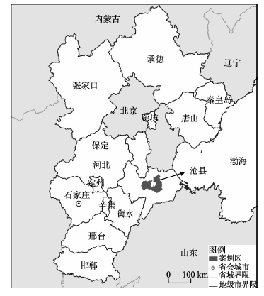
案例区为河北沧县(图1),北靠京津,东临渤海,地理坐标为E116°27′~E117°09′,N38°3′~N38°5′。地处冲积平原向滨海平原过渡地带,地势低平,土壤类型以黄沙土为主,部分地区土壤盐碱化严重;属温带大陆性季风气候,年均气温13 ℃,年均降水量590 mm[16]。冬小麦—夏玉米一年两熟制是主要种植制度。近年来,春玉米一熟制面积不断扩张。冬小麦、夏玉米和春玉米成为最主要的农作物种类,播种面积占农作物总播种面积的90%以上[17-18]。沧县属沧州深层地下水漏斗区。该漏斗区面积约5551 km2,中心水位埋深约92 m,是河北省面积最大、漏斗中心水位最低的漏斗区。《2014年度河北省地下水超采综合治理试点调整农业种植结构和农艺节水项目实施方案》中,选取衡水、沧州、邢台、邯郸4个地区共43个县(市、区)进行冬小麦退耕试点,沧县也包括在内。
 显示原图|下载原图ZIP|生成PPT
图1案例区地理位置
-->Fig. 1Location of the case study area
-->
2.2 数据来源
所用数据来自于作者2015年3-5月在沧县进行的农户问卷调查。农户样本选取采用分层抽样和随机抽样相结合[19]:选取县内6个乡镇,按照均匀布点原则,在每个乡镇选取以地下水为主要灌溉水源的村庄2~3个,每个村庄随机选取10户左右农户进行调查。问卷内容主要包括2013-2014年度农户家庭固定资产情况、家庭收入情况、劳动力特征以及农户所有地块的基本属性、种植作物及分地块分作物的成本—收益信息等。整个调研过程包括预调研和正式调研两个阶段,共收集14个村144份问卷,其中有效问卷134份,问卷有效率为93.1%。2.3 研究方法
在农户主动退耕冬小麦的背景下,确定土地休耕政策的瞄准目标和休耕农户的生态补贴标准是政策执行初期应解决的核心问题。为解决这两个问题,本文构建解释农户不同种植制度决策的多层次logit模型,寻找影响冬小麦空间布局的关键因素。然后,通过成本收益分析,计算冬小麦退耕的机会成本,进而给出休耕农户补偿标准的建议。2.3.1 多层次logit模型 理论上,农户土地利用行为受地块的自然和位置特征、农户的经济和劳动力特征、村庄的区位和地理环境等不同层级因素的影响[20]。数据存在组内同质和组间异质的特征,不符合传统模型关于样本独立、正态分布和方差齐性的假设[21]。多层次模型可将传统模型中的随机误差项分解到与数据层次结构相应的水平上,使得个体的随机误差满足上述假定,是处理多层次数据的有效方法[22],被越来越多地应用于农户土地利用行为及其变化的解释[23-25]。
本文即借助多层次logit模型分析农户种植制度的影响因素。沧县农户的种植制度主要有两种:冬小麦—夏玉米一年两熟制(简称两熟制)和春玉米一年一熟制(简称一熟制)。将两熟制定义为1,一熟制定义为0。p为农户某一地块种植两熟制的概率,1-p为一熟制的概率。构建的多层次logit模型如下:
式中:i、j和k分别表示地块、农户和村庄;γ000表示固定截距;r0和u00分别表示农户和村庄尺度的随机截距,均符合随机分布和均值为0的假设;X、Y、Z和α、β、δ分别表示地块、农户、村庄3个尺度的解释变量及其系数。
跨级相关系数用于评价不同层次对被解释变量总体变异的解释程度[24]:
式中:ρ2、ρ3分别表示农户和村庄的跨级相关系数;
本文在选取农户种植制度的可能影响因素时,也从地块、农户和村庄3个尺度着手,兼顾数据可获取性,最终选取解释变量(表1)。
Tab. 1
表1
表1案例区农户种植制度决策解释变量的定义及描述性统计
Tab. 1Definition and description of the independent variables for farmers' cropping systems in the study area
| 变量名称 | 定义 | 均值 | 方差 | 最小值 | 最大值 |
|---|---|---|---|---|---|
| 地块尺度(N=521) | |||||
| 地块面积 | 地块面积(亩) | 2.09 | 1.41 | 0.10 | 11.00 |
| 土地质量 | 一等地=1,二等地=2,三等地=3,四等地=4 | 1.96 | 0.96 | 1.00 | 4.00 |
| 耕作距离 | 地块到所属农户住宅的距离(km) | 0.84 | 0.55 | 0.05 | 3.00 |
| 灌溉条件 | 虚拟变量(水浇地=1, 旱地=0) | 0.85 | 0.36 | 0.00 | 1.00 |
| 农户尺度(N=134) | |||||
| 农机设备 | 虚拟变量(具备=1,不具备=0) | 0.22 | 0.42 | 0.00 | 1.00 |
| 地块破碎度 | 农户种植地块总数与耕地总面积之比 | 0.51 | 0.21 | 0.17 | 1.35 |
| 人均非农收入 | 农户非农总收入与总人口之比(103元/人) | 12.19 | 8.79 | 0.00 | 45.00 |
| 亩均务农劳动力数量 | 农户务农劳动力总数与耕地面积之比(人/亩) | 0.31 | 0.20 | 0.06 | 1.08 |
| 年龄 | 农户农业决策者的年龄(岁) | 57.38 | 9.68 | 36.00 | 77.00 |
| 受教育程度 | 农户农业决策者的受教育程度(文盲=1,小学=2,初中=3,高中=4,大专及以上=5) | 2.29 | 0.82 | 1.00 | 5.00 |
| 抚养比 | 农户劳动力数量与总人口数量之比 | 0.71 | 0.24 | 0.00 | 1.00 |
| 村庄尺度(N=14) | |||||
| 据市中心距离 | 村庄与城市中心的最短距离(km) | 12.17 | 2.90 | 7.91 | 16.28 |
| 土地流转率 | 村庄流转耕地面积与耕地总面积之比 | 0.06 | 0.11 | 0.00 | 0.42 |
| 灌溉用电单价 | 村庄灌溉用电单价(元/度) | 0.59 | 0.40 | 0.00 | 1.00 |
新窗口打开
2.3.2 机会成本计算 从管理者的角度而言,生态补偿标准通常以保护导致的净收益损失(机会成本)作为最小补偿,而以原有土地利用方式导致的损失(即生态成本或保护的生态收益)作为最高补偿[26]。补偿标准的确定主要有3种思路[27]:计算生态保护的机会成本,确定经济补偿量;采用商品价格法,计算生态效益的经济价值,作为补偿标准;综合考虑成本补偿、生态价值补偿和利益相关者参与激励等多种因素确定补偿标准。其中,机会成本支付原则是世界范围内应用最为广泛的生态补偿标准确定依据[13]。美国的耕地保护储备计划和中国的退耕还林两大生态补偿项目均以耕地休耕或退耕的机会成本作为补偿标准[28]。
采用机会成本法确定农户退耕冬小麦的补偿标准:
式中:OC为农户退耕冬小麦的机会成本;πa和πb分别表示地块退耕前后的净收益(元/亩)。若案例区夏玉米和春玉米的净收益相等,OC可近似等于地块种植冬小麦的净收益(πww,元/亩);若不相等,则OC等于地块种植冬小麦—夏玉米两熟制的净收益总和(πww+πsm,元/亩)与春玉米一熟制的净收益(πcm,元/亩)之差。其中,作物的净收益(π,元/亩)可通过地块的成本—收益分析获得:
式中:p为农户出售农产品的价格(元/斤);Y为作物的单产(斤/亩);
式中:G为农业总收益(元);L为农业劳动总投入(工日);γ为劳动投入的弹性系数,利用柯布—道格拉斯生产函数进行估计[30],模型如下:
式中:α为常数项;A、L和C分别为土地、劳动力和资本投入;β、γ和θ分别为对应的弹性系数;Z为影响农业总收益的耕作条件、气候因素、劳动力特征等外部因素,δ为对应的系数;ε为残差项。
3 结果与分析
3.1 农户种植制度影响因素分析与退耕目标确定
在农户主动退耕冬小麦的背景下,识别农户种植制度的影响因素,有助于土地休耕政策瞄准尚未退耕的地块,有效提高政策执行效率和成本有效性[14]。表2给出了不包括任何解释变量(模型1)、仅包括地块层次解释变量(模型2)、包括地块和农户层次解释变量(模型3)和包括全部层次解释变量(模型4)的多层次logit模型的模拟结果。Tab. 2
表2
表2案例区农户种植制度影响因素的多层次logit模型结果
Tab. 2Results of multi-level logit models for factors influencing farmers' cropping systems in the study area
| 模型1 | 模型2 | 模型3 | 模型4 | |
|---|---|---|---|---|
| 固定效应 | ||||
| 截距项 | -0.008 | -0.050 | -0.009 | 1.984 |
| 地块尺度(N = 521) | ||||
| 地块面积 | 0.065 | 0.067 | 0.094 | |
| 土地质量 | -0.498*** | -0.523*** | -0.765*** | |
| 耕作距离 | -0.184 | -0.175 | -0.287 | |
| 灌溉条件 | 3.314*** | 3.352*** | 4.630*** | |
| 农户尺度(N = 134) | ||||
| 农机设备 | 0.466** | 0.833** | ||
| 地块破碎度 | -2.153** | -3.134** | ||
| 人均非农收入 | -0.025* | -0.033* | ||
| 亩均务农劳动力数量 | 2.087*** | 3.146*** | ||
| 年龄 | 0.250*** | 0.344** | ||
| 年龄的二次方 | -0.002*** | -0.003* | ||
| 受教育程度 | -0.001 | -0.002 | ||
| 抚养比 | 0.366 | 0.619 | ||
| 村庄尺度(N = 14) | ||||
| 距市中心距离 | 0.017 | |||
| 土地流转率 | 4.762* | |||
| 灌溉用电单价 | -4.016*** | |||
| 随机效应 | ||||
| 农户尺度 | ||||
| VAR(r0) | 0.180 | 0.530 | 0.060 | 0.120 |
| ρ2 | 0.032 | 0.074 | 0.008 | 0.031 |
| 村庄尺度 | ||||
| VAR(u00) | 2.265*** | 3.444*** | 4.317*** | 0.659*** |
| ρ3 | 0.405 | 0.484 | 0.574 | 0.168 |
| ROC | 0.846 | 0.920 | 0.913 | 0.915 |
新窗口打开
模型1也被称为“空模型”,主要用于检测高层次的变异是否显著,还可用于分析各层次对于被解释变量的解释程度[22]。结果显示,村庄层次的方差(
模型2的结果显示,地块层次的土地质量和灌溉条件两个因素对种植制度有显著影响;而地块面积和耕作距离的影响并不显著。模型3的结果显示,地块层次上变量的作用方向和程度与模型2近似。农户层次上,农机设备和亩均务农劳动力数量对两熟制的选择有显著的正效应;地块破碎度和人均非农收入对两熟制的选择有显著的负效应。农业决策者的年龄和年龄的二次方项均显著,但影响方向不同:前者为正,后者为负,说明家庭决策者年龄过大或过小都会降低两熟制的概率。此外,农业决策者的受教育程度和抚养比这两个变量对种植制度的影响并不显著。模型4的结果显示,地块和农户层次各变量的作用方向与模型2和模型3一致。村庄尺度上,灌溉用电单价对两熟制的选择呈现显著的负效应;土地流转率则呈正效应,但考虑到村庄土地流转率的均值仅为6%(表1),这一变量对种植制度变异的解释程度较为有限。村庄的地理位置(距市中心距离)并未呈现显著影响。
总体而言,多层次logit模型的结果分析表明,地块层次对种植制度变异的解释程度最高(56.2%),其次为村庄层次(40.5%),农户层次的解释程度仅为3.2%。ROC值[22]也表明,仅包括地块层次的解释变量即可实现模型的最佳拟合效果(表2)。
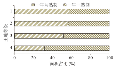
具体考虑地块层次的土地质量和灌溉条件对种植制度的影响:土地质量越好,两熟制的概率越大,除四等地外,其余三等耕地两熟制的面积占比均在50%以上(图2);有灌溉条件的水浇地比旱地采用两熟制的可能性更大,后者的两熟制面积占比仅为9.2%,而前者的这一比例高达62.5%(图3)。据此,建议土地休耕政策瞄准一、二、三等土地质量的水浇地,着重促使上述属性的地块退耕冬小麦。
 显示原图|下载原图ZIP|生成PPT
图2案例区土地等级与两种种植制度面积占比
-->Fig. 2Land qualities and the ratios of sown areas to two cropping systems in the study area
-->
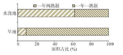 显示原图|下载原图ZIP|生成PPT
图3案例区灌溉条件与两种种植制度面积占比
-->Fig. 3Irrigation conditions and the ratios of sown areas to two cropping systems in the study area
-->
3.2 生态补偿标准确定
3.2.1 务农劳动力的影子工资 利用农户问卷数据估计柯布—道格拉斯生产函数。其中,被解释变量为农户2014年种植冬小麦、夏玉米和春玉米总收益的对数值。借助Stata 13.0进行OLS回归,结果如表3所示。根据表3,调整R2 = 0.914,说明模型的拟合效果较好,结果可信度高。其中,总劳动投入的弹性系数为0.099,将该系数带入公式(5),求出沧县2014年务农劳动力的平均影子工资为46.8元/工日,可将其带入公式(4)计算不同地块作物的净收益。值得一提的是,沧县农户的资本投入与播种面积之间存在极强的共线性,相关系数达0.952,在进行OLS回归时将其剔除。
Tab. 3
表3
表3案例区柯布—道格拉斯生产函数估计结果
Tab. 3Estimation results of Cobb-Douglas production function in the study area
| 变量 | 系数 | t值 | P值 | 变量 | 系数 | t值 | P值 |
|---|---|---|---|---|---|---|---|
| 常数项 | 7.000*** | 49.85 | 0.000 | 受灾面积占比 | -0.517*** | -10.78 | 0.000 |
| ln(总播种面积) | 0.901*** | 19.44 | 0.000 | 农业决策者年龄 | -0.003* | -1.68 | 0.095 |
| ln(总劳动投入) | 0.099** | 2.08 | 0.040 | 农业决策者受教育程度 | -0.006 | -0.29 | 0.770 |
| 优质耕地面积占比 | 0.150*** | 3.05 | 0.003 | 务农劳动力中男性占比 | -0.008 | -0.13 | 0.893 |
| 样本数 | 134 | ||||||
| 调整R2 | 0.914 | ||||||
新窗口打开
Tab. 4
表4
表4案例区不同灌溉条件地块的独立样本T检验结果
Tab. 4Results of independent-samples T test for plots with different irrigation conditions in the study area
| 作物类别 | 水浇地 | 旱地 | |||||||
|---|---|---|---|---|---|---|---|---|---|
| 样本数 | 平均值 | t值 | P值 | 样本数 | 平均值 | t值 | P值 | ||
| 春玉米 | 30 | 593.82 | 1.233 | 0.220 | 63 | 619.13 | -0.513 | 0.609 | |
| 夏玉米 | 83 | 648.76 | 53 | 594.39 | |||||
新窗口打开
Tab. 5
表5
表5案例区不同土地质量地块的独立样本T检验结果
Tab. 5Results of independent-samples T test for plots with different land qualities in the study area
| 作物类别 | 一等地 | 二等地 | |||||||
|---|---|---|---|---|---|---|---|---|---|
| 样本数 | 平均值 | t值 | P值 | 样本数 | 平均值 | t值 | P值 | ||
| 春玉米 | 34 | 746.68 | -1.064 | 0.290 | 22 | 654.00 | -0.475 | 0.637 | |
| 夏玉米 | 66 | 696.26 | 42 | 630.26 | |||||
| 作物类别 | 三等地 | 四等地 | |||||||
| 样本数 | 平均值 | t值 | P值 | 样本数 | 平均值 | t值 | P值 | ||
| 春玉米 | 25 | 550.75 | -0.756 | 0.454 | 12 | 272.96 | -0.459 | 0.653 | |
| 夏玉米 | 23 | 510.41 | 5 | 237.31 | |||||
新窗口打开
3.2.2 春、夏玉米净收益差异 因土地休耕政策尚未落实,无法获取同一地块种植夏玉米和春玉米的净收益,采用相似耕作条件地块种植春、夏玉米的净收益近似代替。具体地,分析相同土地质量或灌溉条件下地块种植春、夏玉米净收益平均值的差异,借助SPSS中的独立样本T检验进行(表4,表5)。
独立样本T检验的结果显示:不同灌溉条件的地块种植春、夏玉米净收益的平均值均不存在显著差异,P值均大于0.1(表4);同样,4种土地质量等级的地块种植春、夏玉米净收益平均值的差异也都未达到显著水平,P值最小为一等地,但仍大于0.1(表5)。因此,尽管春、夏玉米的生育周期不同,相近耕作条件的地块种植春玉米的净收益和种植夏玉米的净收益却差别不大。根据公式(3),农户退耕冬小麦的机会成本可近似等于种植冬小麦的净收益。
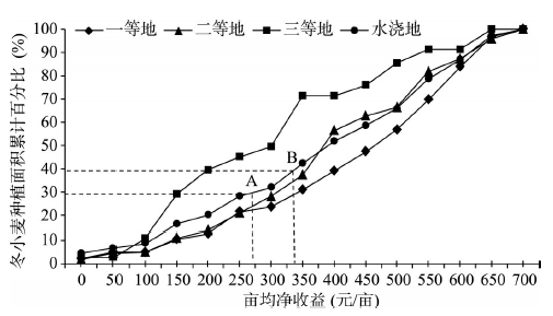
3.2.3 冬小麦机会成本与退耕补偿标准 如前所述,近70%的四等耕地和90%以上的旱地已出现农户主动退耕冬小麦现象,现有冬小麦主要布局在土地质量较好的一、二、三等水浇地上,因而上述类型地块将是未来土地休耕政策瞄准的重点。按照公式(3)计算冬小麦的净收益(图4)。
 显示原图|下载原图ZIP|生成PPT
图4案例区土地质量、亩均净收益与冬小麦种植面积累计百分比
-->Fig. 4Land quality, net-profit per mu and cumulative percentage of area sown to winter wheat in the study area
-->
根据图4,不同亩均净收益时,不同质量水浇地的冬小麦种植面积累计百分比(简称累计百分比)不尽相同。其中,亩均净收益在100元/亩以内时,3种质量水浇地的累计百分比差异不大;250元/亩以内时,二、三等水浇地的累计百分比基本吻合,但与三等水浇地有较大差异;随着亩均净收益不断增加,3种质量水浇地的累计百分比各不相同,亩均净收益介于250~600元/亩时,累计百分比均表现为三等水浇地>二等水浇地>一等水浇地。一、二、三等水浇地中亩均净收益超过600元/亩的面积占比均较少,3条曲线渐趋重合。就水浇地而言,其累计百分比均介于一、三等水浇地之间,亩均净收益超过400元/亩时,与二等水浇地的累计百分比基本吻合。
生态补偿实践中,通常采用机会成本的平均值作为补偿标准确定的依据[28]。一、二、三等水浇地种植冬小麦的亩均净收益均值分别为424元/亩、380元/亩和291元/亩;若考虑全部水浇地,冬小麦的亩均净收益均值则为367元/亩。假设农户种植冬小麦的亩均净收益低于补偿标准时将会执行冬小麦退耕决策,图4中与亩均净收益相对应的冬小麦种植面积累计百分比也可视为相应补贴标准时冬小麦退耕面积的累计百分比。就全部水浇地而言,若按照上述最低值291元/亩进行补贴,将有31.2%的水浇地退耕冬小麦;若按照平均值367元/亩进行补贴,将有46.0%的水浇地退耕冬小麦;若按照最高标准424元/亩进行补贴,退耕比例将提高至55%。可见,补偿标准不同,冬小麦退耕面积的累计百分比存在较大差异;具体补偿标准须依据政府部门制订的冬小麦退耕面积比例确定。
目前,土地休耕的相关政策法规中尚未对华北地下水超采区冬小麦退耕的面积或其比例做出明确规定。仅从地下水治理角度出发,地下水开采量减少29.2%时,地下水位将停止下降;而地下水开采量减少39.2%时,地下水位可能恢复到20世纪50年代的水平[31]。仅考虑冬小麦对地下水资源的影响,因冬小麦面积减少比例与其节省的地下水资源量的比例基本一致[32],尝试将上述两个临界值应用于冬小麦退耕面积比例的确定,对应的亩均净收益分别为273元/亩和341元/亩(图4)。据此,在土地休耕政策初期,为尽快回升地下水位并恢复地下水环境,可将350元/亩作为冬小麦退耕的补偿标准参考值,这与全部水浇地冬小麦退耕的平均机会成本较为一致;随着政策执行年份的增长,目标逐渐转向维持地下水资源采补平衡,补偿标准可适当压减,可将其调整至280元/亩左右,接近三等水浇地冬小麦退耕的平均机会成本。
4 结论与讨论
4.1 结论
(1)从地块、农户和村庄3个层次进行的种植制度决策影响因素分析显示,地块特征对农户种植制度选择行为的解释程度最高(56.2%),其次为村庄特征(40.5%),而农户特征的解释程度最小(3.2%);仅包括地块层次解释变量的多层次logit模型拟合效果最优(ROC = 0.920)。(2)近70%的四等耕地和90%以上的旱地已出现农户主动退耕冬小麦现象,现有冬小麦主要布局在可灌溉的水浇地和土地质量较好的一、二、三等耕地上。土地休耕政策应瞄准一、二、三等土地质量的水浇地,着重促使上述属性的地块退耕冬小麦。
(3)相似耕作条件下,春、夏玉米的净收益并不存在显著差异,土地休耕的机会成本等于种植冬小麦的净收益。
(4)仅考虑冬小麦对地下水资源的影响,土地休耕政策初期以地下水位回升和地下水环境恢复为主要目标时,建议补偿标准为350元/亩左右;后期以维持地下水资源采补平衡为主要目标时,建议补偿标准为280元/亩左右。
4.2 讨论
关于农户冬小麦退耕的生态补偿标准,《2014年度河北省地下水超采综合治理试点调整农业种植结构和农艺节水项目实施方案》中将其暂定为500元/亩,但这一标准的制订依据并不充分,且尚未付诸实施。本文借助农户问卷数据,在分析农户种植制度影响因素的基础上,通过冬小麦退耕的机会成本计算,给出土地休耕政策重点瞄准地块冬小麦退耕的生态补偿标准建议。本文建议的补偿标准遵循既定的科学依据且显著低于500元/亩,可有效降低政策的投入成本,具有积极的政策含义。然而,本文仅以沧县2013-2014年度种植冬小麦的净收益作为机会成本,今后需扩展案例区范围,跟踪进行农户问卷调研工作,以期给出更为合理的华北地下水超采区冬小麦退耕的补偿标准。此外,华北平原种植冬小麦的生态负面作用主要是超采地下水资源,还包括农药、化肥的过量使用等;同时,种植冬小麦也有积极的生态意义,如净化空气、保持水土等。
The authors have declared that no competing interests exist.
参考文献 原文顺序
文献年度倒序
文中引用次数倒序
被引期刊影响因子
| [1] | Groundwater is a life-sustaining resource that supplies water to billions of people, plays a central part in irrigated agriculture and influences the health of many ecosystems. Most assessments of global water resources have focused on surface water, but unsustainable depletion of groundwater has recently been documented on both regional and global scales. It remains unclear how the rate of global groundwater depletion compares to the rate of natural renewal and the supply needed to support ecosystems. Here we define the groundwater footprint (the area required to sustain groundwater use and groundwater-dependent ecosystem services) and show that humans are overexploiting groundwater in many large aquifers that are critical to agriculture, especially in Asia and North America. We estimate that the size of the global groundwater footprint is currently about 3.5 times the actual area of aquifers and that about 1.7 billion people live in areas where groundwater resources and/or groundwater-dependent ecosystems are under threat. That said, 80 per cent of aquifers have a groundwater footprint that is less than their area, meaning that the net global value is driven by a few heavily overexploited aquifers. The groundwater footprint is the first tool suitable for consistently evaluating the use, renewal and ecosystem requirements of groundwater at an aquifer scale. It can be combined with the water footprint and virtual water calculations, and be used to assess the potential for increasing agricultural yields with renewable groundwaterref. The method could be modified to evaluate other resources with renewal rates that are slow and spatially heterogeneous, such as fisheries, forestry or soil. |
| [2] | |
| [3] | |
| [4] | <p>本文利用简化的水量平衡模型,模拟了河北平原1985-1995年多年平均降水入渗系数和含水层给水度,在此基础上计算出各用水部门和各种农作物平均每年引起的地下水位下降幅度。结果表明:农业用水是引起河北平原地下水位下降的主要因素,其次是工业用水和生活用水。小麦引起的地下水位下降幅度最大,谷子最小。生产单位产值的小麦消耗地下水量最大,引起的地下水位下降幅度也最大,生产单位产值的蔬菜消耗地下水量最小,引起的地下水位下降幅度也最小。实现河北平原地下水资源可持续利用,调整种植业结构当务之急。</p> . <p>本文利用简化的水量平衡模型,模拟了河北平原1985-1995年多年平均降水入渗系数和含水层给水度,在此基础上计算出各用水部门和各种农作物平均每年引起的地下水位下降幅度。结果表明:农业用水是引起河北平原地下水位下降的主要因素,其次是工业用水和生活用水。小麦引起的地下水位下降幅度最大,谷子最小。生产单位产值的小麦消耗地下水量最大,引起的地下水位下降幅度也最大,生产单位产值的蔬菜消耗地下水量最小,引起的地下水位下降幅度也最小。实现河北平原地下水资源可持续利用,调整种植业结构当务之急。</p> |
| [5] | Agricultural land use is affected by government policies and leads to different consequences of regional sustainability. In this work, changes in cropping patterns including acreage, cropping locations and management-related environmental impacts were simulated under various policy scenarios for Quzhou County, China. This county is in China's major agricultural region, the North China Plain. Four dominant crop systems were categorized (winter wheat/summer maize, winter wheat/summer maize/spring maize, cotton, and vegetables) and analyzed, following two alternative policy scenarios that either prioritized government funding to subsidize crop production (“subsidy” scenario) or promoted advanced irrigation techniques (“technique” scenario). Input–output coefficients for all four crop systems were determined, mainly irrigation demand, yield, and price of produce, but other factors like a limited area of arable land and scarce regional water resources were also considered. For the simulation, a LINDO Inc. system was linked with the CLUE (Conversion of Land Use and its Effects) model. Temporal changes of crop systems were simulated with the LINDO system, whereas spatial dynamics of cropping patterns were simulated with the CLUE model, based on land suitability maps. The results show that crop patterns changed variably with time under the two scenarios, and water availability was the primary constraint on sustainability of land use. Under the subsidy scenario, winter wheat/summer maize/spring maize became dominant across the entire county, replacing other crop systems. In contrast, the vegetable system gradually occupied farmland surrounding the township under the technique scenario. The different policies produced opposite consequences for regional sustainability. Although a “subsidy” policy contributed to farmers’ income, it did not encourage water conservation for sustainable crop production, leading to land abandonment because of water shortage. In contrast, the “technique” policy partially cut direct financial benefits to farmers, but promoted water conservation and made a substantial contribution to agricultural sustainability. |
| [6] | The results showed that after a 75-mm pre-sowing irrigation, soil water content and AWC in the root zone of a 2-m soil profile during sowing were 31.1% (or 90.7% of field capacity) and 16.1%, respectively. Rainfall events were variable and showed a limited impact on AWC. The AWC decreased significantly with the growth of wheat. At the jointing stage no water deficits occurred for all treatments, at the flowering stage water deficits were found only in the rain-fed treatment, and at harvest all treatments had moderate to severe soil water deficits. The SWU in the 2-m soil profile was negatively related to the irrigation water volume, i.e. applying 7502mm irrigation reduced SWU by 28.202mm. Regression analyses showed that relationships between ET and grain yield or WUE could be described by quadratic functions. Grain yield and WUE reached their maximum values of 742302kg/ha and 1.64502kg/m 3 at the ET rate of 509 and 38202mm, respectively. IWUE was negatively correlated with irrigated water volume. From the above results, three irrigation schedules: (1) pre-sowing irrigation only, (2) pre-sowing irrigation02+02irrigation at jointing or booting stage, and (3) pre-sowing irrigation02+02irrigations at jointing and flowering stages were identified and recommended for practical winter wheat production in the NCP. |
| [7] | |
| [8] | A groundwater crisis is going on in the North China Plain (NCP), due to the excessive water consumption of the traditional winter wheat (WW)/summer maize (SM) double cropping system (two harvests in one year). In order to improve the water use efficiency in this particular cropping system and to evaluate the sustainability of water usage in Chinese agroecosystems, two field experiments were conducted from October 2004 to September 2006 at two sites of the North China Plain. The field experiments included four treatments: (1) farmers' practice (FP) with two harvests in one year (WW/SM rotation), (2) FP with reduced input (RI) of water and nitrogen (WW/SM rotation), (3) three harvests in two years (TW, 1st year: WW/SM; 2nd year: spring maize), and (4) continuous spring-maize monoculture (CS) with one harvest per year (spring maize). In the treatments RI, TW and CS, the amount and timing of irrigation and nitrogen fertilization was optimized using TDR based soil moisture measurements and the N(min)-method, respectively. Data showed that the utilization efficiency of irrigation water can be improved by optimizing soil water management compared to the traditional water management (FP). However, the groundwater net consumption required for RI still surpassed 300 mm yr(-1). Both FP and RI, still overused groundwater resources. The groundwater consumption in the continuous spring maize (CS) was on average 139 mm yr(-1). Therefore, the CS system can show the potential to use groundwater sustainably in the long term. Water usage of the TW treatment was in between the water usage of the other treatments. The grain yields in the double cropping systems (FP and RI) were higher than that in the two other systems (TW and CS). But the CS treatment showed the higher W(UE) than others. (c) 2010 Elsevier B.V. All rights reserved. |
| [9] | Increased water use in the Hebei Plain during the last decades has caused serious groundwater level decline and many geological problems which have become the biggest threat to social-economic sustainability. Thus, to determine the factors resulting in the groundwater decline and to develop a practical plan for long-term groundwater use appear to be necessary in this region. In this paper, a water balance model is used in conjunction with regression techniques to estimate the groundwater recharge coefficient and the specific yield (defined as the ratio of the volume of water that a saturated rock or soil will release by gravity drainage to the volume of rock or soil) and the groundwater withdrawn by different water use sectors and the corresponding drop in the watertable are analyzed. The decline in water-table by different crops and water economic benefit of crops are discussed in detail in order to suggest sustainable use of groundwater resources in the Hebei Plain. Finally, sample policy scenarios are developed to show how groundwater in the Hebei Plain could be used in a sustainable manner. In our study, it is found that agriculture is the major consumer of groundwater, with about 85% of the total groundwater withdrawals, and groundwater depletion is mainly caused by agricultural water use. Production of winter wheat exerts a great negative influence on the groundwater system. Winter wheat is the most water consuming crop and result in significant decline of groundwater table. Water economic benefit of winter wheat is lower than that of other crops and withdrawing winter wheat sown area is rational option to make sustainable use of groundwater. With far-sighted and regional planning, the limited water resource can be used sustainably to generate maximum social benefits. This paper will provide information necessary for land-use planning in a severe water shortage region where farmland is mainly irrigated by groundwater. (c) 2004 Elsevier B.V. All rights reserved. |
| [10] | Although irrigation has markedly increased agricultural productivity in the North China Plain, it has reduced groundwater levels by up to 0.8myr63641; and dried up the Yellow River for extended times since the 1970s. The objective of this study was to compare water, energy, and carbon fluxes in regions irrigated with groundwater and surface water (Yellow River) using almost four years of eddy covariance data from agricultural stations in Luancheng (water table depth: 6542m) and Weishan (near Yellow River, water table depth: 1–3m). Irrigation is mostly restricted to winter as summer grows during the rainy season. Mean annual ET was 693mmyr63641; for Luancheng site, which is higher than Weishan site (648mm, ignore partial years). About 65390–480mm of ET occurred during the season (from early October to next early June, about 247 days), 230–300mm in the season (from early June to late September, about 107 days). Annual crop yields were 656864kg/ha in the two regions. Annual water use efficiencies ranged from 4 to 6gCO60kg63641;H60O. Water use efficiencies were higher for than for . Annual cropland carbon budget (CCB) was 230–280gCm63642;yr63641; at the two sites and suggested a weak carbon sink. Irrigation compensated for seasonal and inter-annual variability in precipitation. Shifting the cropping pattern from –double crops to a single crop of could significantly reduce water withdrawal and lead to a more sustainable use of water resource in this region. |
| [11] | 以河北平原1998-2010 年11 地市的农业统计数据和22 个气象站点的逐日气温、降水量、水汽压、风速、日照时数和相对湿度等资料为基础,对该地区冬小麦播种面积的收缩情况及由此引发的耕作制度变化进行了分析;同时,结合作物系数法和逐旬有效降水量法,计算了不同耕作制度下的水分亏缺量,进而估算了该地区因耕作制度变化节省的水资源量。结果表明:① 该时段河北平原11 地市冬小麦的播种面积均呈收缩趋势,总面积下降了16.07%,约49.62×10<sup>4</sup> hm<sup>2</sup>。京津唐城市群表现最为明显,下降了47.23%;② 冬小麦的降水满足率仅为20%~30%,而春玉米和夏玉米均为50%以上;冬小麦—夏玉米一年两熟制所需的灌溉水资源量为400~530 mm,而春玉米一年一熟制仅为160~210 mm;③ 该时段河北平原因冬小麦播种面积收缩而节省的灌溉水资源量约为15.96×10<sup>8</sup> m<sup>3</sup>/a,相当于南水北调中线一期工程为京津冀三省市供水量的27.85%。 . 以河北平原1998-2010 年11 地市的农业统计数据和22 个气象站点的逐日气温、降水量、水汽压、风速、日照时数和相对湿度等资料为基础,对该地区冬小麦播种面积的收缩情况及由此引发的耕作制度变化进行了分析;同时,结合作物系数法和逐旬有效降水量法,计算了不同耕作制度下的水分亏缺量,进而估算了该地区因耕作制度变化节省的水资源量。结果表明:① 该时段河北平原11 地市冬小麦的播种面积均呈收缩趋势,总面积下降了16.07%,约49.62×10<sup>4</sup> hm<sup>2</sup>。京津唐城市群表现最为明显,下降了47.23%;② 冬小麦的降水满足率仅为20%~30%,而春玉米和夏玉米均为50%以上;冬小麦—夏玉米一年两熟制所需的灌溉水资源量为400~530 mm,而春玉米一年一熟制仅为160~210 mm;③ 该时段河北平原因冬小麦播种面积收缩而节省的灌溉水资源量约为15.96×10<sup>8</sup> m<sup>3</sup>/a,相当于南水北调中线一期工程为京津冀三省市供水量的27.85%。 |
| [12] | <a name="Abs1"></a>Due to the over use of available water resources, it has become very important to define appropriate strategies for planning and management of irrigated farmland. In this paper, Beijing-Tianjin-Hebei (Jing-Jin-Ji) region was chosen as the case study area for its special political and economic status and its severe water problem. To achieve effective planning, the information about crop water requirements, irrigation withdrawals, soil types and climatic conditions were obtained in the study area. In the meantime, a GIS method was adopted, which extends the capabilities of the crop models to a regional level. The main objectives of the study are: 1) to estimate the spatial distribution of the evapotranspiration of spring maize; 2) to estimate climatic water deficit; 3) to estimate the yield reduction of spring maize under different rainfed and irrigated conditions. Based on the water deficit analysis, recommended supplemental irrigation schedule was developed using CropWat model. Compared to the rainfed control, the two or three times of supplemental water irrigated to spring maize at the right time reduced the loss of yield, under different scenarios. |
| [13] | . . |
| [14] | . |
| [15] | |
| [16] | |
| [17] | |
| [18] | 为及时、准确地获取华北平原冬小麦时空分布信息,构建多源遥感监测系统,基于MODIS EVI时间序列数据和两景TM影像,建立华北平原冬小麦时序波谱曲线库,并结合农作物物候历制订统一规则,在此基础上,重建华北平原2001-2011年冬小麦播种面积时空变化过程。结果表明:1)多源遥感监测系统提取华北平原2001-2011年冬小麦信息,在栅格尺度上获得了稳定的较高分类精度,平均为76.36%;在县域行政单元尺度上,2011年的冬小麦遥感监测面积与统计数据的耦合度也较高(决定系数为0.89,均方根误差为1.29×10⁴ hm2);2)华北平原2001-2011年的冬小麦播种面积呈持续上升趋势,2011年比2001年增加了156.05×10⁴ hm2(14.96%);3)冬小麦播种面积大致呈"南增北减"的时空变化格局:平原中南部的鲁西南平原、胶莱平原、豫东平原和皖北平原冬小麦种植面积扩张趋势显著;而北部的京津冀地区冬小麦面积明显收缩。该研究旨在为华北平原调整农业种植结构、制订粮食安全策略及优化水资源管理提供数据支持,也可为大范围、长时间尺度的作物播种面积时空变化遥感监测提供方法借鉴。 . 为及时、准确地获取华北平原冬小麦时空分布信息,构建多源遥感监测系统,基于MODIS EVI时间序列数据和两景TM影像,建立华北平原冬小麦时序波谱曲线库,并结合农作物物候历制订统一规则,在此基础上,重建华北平原2001-2011年冬小麦播种面积时空变化过程。结果表明:1)多源遥感监测系统提取华北平原2001-2011年冬小麦信息,在栅格尺度上获得了稳定的较高分类精度,平均为76.36%;在县域行政单元尺度上,2011年的冬小麦遥感监测面积与统计数据的耦合度也较高(决定系数为0.89,均方根误差为1.29×10⁴ hm2);2)华北平原2001-2011年的冬小麦播种面积呈持续上升趋势,2011年比2001年增加了156.05×10⁴ hm2(14.96%);3)冬小麦播种面积大致呈"南增北减"的时空变化格局:平原中南部的鲁西南平原、胶莱平原、豫东平原和皖北平原冬小麦种植面积扩张趋势显著;而北部的京津冀地区冬小麦面积明显收缩。该研究旨在为华北平原调整农业种植结构、制订粮食安全策略及优化水资源管理提供数据支持,也可为大范围、长时间尺度的作物播种面积时空变化遥感监测提供方法借鉴。 |
| [19] | <p>非农化是中国快速工业化、城镇化进程中农村演变的重要趋势,呈现出明显的空间异质性。以山东省沂水县为例,选取16个典型样点村,根据农户就业地域空间差异,将农户就业划分为县域外非农就业、县域非农就业、县域非农兼业和农业生产4类,在此基础上,选取非农就业劳动力、收入和时间比例3个指标研究县域农村非农化程度差异及驱动力。结果表明,沂水县农村非农化程度介于37.54%~90.65%,非农化现象普遍。县域农村非农化程度的总体分布特征为:近郊村最高;随着与城镇的临近,粮食作物主导村提高、经济作物主导村降低;同一地形区内,粮食作物主导村高于经济作物主导村。农村非农分化趋势明显。驱动力研究表明,受县域城镇经济实力、农村到城镇的可达性,农业收益及劳动需求量等的综合影响,不同类型农村劳动力就业结构存在差异,进而导致县域农村非农化程度的差异。研究认为,当前农村非农化普遍,且非农分化明显。政府应根据不同类型农村非农化程度差异的内容及驱动因素,实施差别化的农村发展管理措施。</p> . <p>非农化是中国快速工业化、城镇化进程中农村演变的重要趋势,呈现出明显的空间异质性。以山东省沂水县为例,选取16个典型样点村,根据农户就业地域空间差异,将农户就业划分为县域外非农就业、县域非农就业、县域非农兼业和农业生产4类,在此基础上,选取非农就业劳动力、收入和时间比例3个指标研究县域农村非农化程度差异及驱动力。结果表明,沂水县农村非农化程度介于37.54%~90.65%,非农化现象普遍。县域农村非农化程度的总体分布特征为:近郊村最高;随着与城镇的临近,粮食作物主导村提高、经济作物主导村降低;同一地形区内,粮食作物主导村高于经济作物主导村。农村非农分化趋势明显。驱动力研究表明,受县域城镇经济实力、农村到城镇的可达性,农业收益及劳动需求量等的综合影响,不同类型农村劳动力就业结构存在差异,进而导致县域农村非农化程度的差异。研究认为,当前农村非农化普遍,且非农分化明显。政府应根据不同类型农村非农化程度差异的内容及驱动因素,实施差别化的农村发展管理措施。</p> |
| [20] | <p>土地利用变化驱动力研究一直是****们关注的热点问题之一,土地利用驱动力在不同尺度的变化也越来越受****们关注。论文以陕西省米脂县高西沟村为研究区域,在地形图、航片解译数据及2009年实际测量数据和农户调查数据的基础上,基于多层次模型的理论,借助HLM6.07(student)软件工具,构建从地块(微观尺度)到农户(中观尺度)的二层土地利用决策影响因素模型,试图揭示微观层面土地利用决策的影响因素在不同尺度上的变化机制。研究结果表明:①农户选择种植土豆、谷子作物的土地利用决策与地块的自然因素和农户的社会经济因素有关;②农户种植土豆、谷子行为决策的影响因素存在差异;③将多层次模型应用到从微观尺度到中观尺度分析农户土地利用决策影响因素是符合实际情况的,这为进一步构建影响农户土地利用决策的因素——微观尺度(地块)、中观尺度(农户)、宏观尺度(村庄)的三层模型奠定了基础,同时为研究土地利用决策机制提供了一种方法。</p> . <p>土地利用变化驱动力研究一直是****们关注的热点问题之一,土地利用驱动力在不同尺度的变化也越来越受****们关注。论文以陕西省米脂县高西沟村为研究区域,在地形图、航片解译数据及2009年实际测量数据和农户调查数据的基础上,基于多层次模型的理论,借助HLM6.07(student)软件工具,构建从地块(微观尺度)到农户(中观尺度)的二层土地利用决策影响因素模型,试图揭示微观层面土地利用决策的影响因素在不同尺度上的变化机制。研究结果表明:①农户选择种植土豆、谷子作物的土地利用决策与地块的自然因素和农户的社会经济因素有关;②农户种植土豆、谷子行为决策的影响因素存在差异;③将多层次模型应用到从微观尺度到中观尺度分析农户土地利用决策影响因素是符合实际情况的,这为进一步构建影响农户土地利用决策的因素——微观尺度(地块)、中观尺度(农户)、宏观尺度(村庄)的三层模型奠定了基础,同时为研究土地利用决策机制提供了一种方法。</p> |
| [21] | |
| [22] | |
| [23] | |
| [24] | Cropland abandonment accompanying economic development has been observed worldwide. China has experienced a large amount of land abandonment in recent years. However, the reasons for it are not entirely clear. Although abandonment decisions are made by individual households, the underlying conditions reflect processes operating at multiple levels. Therefore, we aimed to detect the influences on land abandonment at the parcel, household and village levels. We developed and employed a multi-level statistical model using farm household survey data and geographical maps of Wulong County. Our model revealed that of the variance in occurrence of land parcel abandonment, 7% and 13% can be explained at the household and village levels, respectively, while the remnant 80% can be explained at the land parcel features itself. We found that land abandonment is more prone to occur on parcels that are on steep slopes, have poor quality soil, or are remote from the laborers鈥 residences. Households with less agricultural labor per unit land area showed a high probability of land abandonment. We also found a nonlinear influence of labor age on land abandonment, with households comprising middle-aged laborers having a low land abandonment probability. Parcels in villages with high elevation, far from the county administrative center or with low prevalence of leased land are inclined to abandonment. We also found, surprisingly, that the household proportion of males among its agricultural laborers did not significantly influence the occurrence of land abandonment at the parcel level, probably due to the male agricultural laborers being overwhelmingly old (average age greater than 56 years). To alleviate land abandonment, we suggest improving land tenure and transfer security to ensure stable access to the land rental market, and also improving infrastructure in remote regions. |
| [25] | . |
| [26] | |
| [27] | 经济补偿作为一项政策措施 ,对保障当前西部开发进程中退耕还林还草工作的顺利展开 ,发挥着十分重要的作用。然而 ,作为我国植被生态建设中一个全新的举措 ,目前经济补偿政策的实施刚刚开始 ,有关的理论研究尚处于初步的探讨阶段。循着“为什么要补偿 ?→补偿多少 ?→如何补偿 ?”的思路 ,建立了经济补偿的概念模型 ,着重探讨了补偿标准的确定以及多层次补偿制度建立等问题 ,并对目前处于试点示范中的经济补偿政策进行了评述。 . 经济补偿作为一项政策措施 ,对保障当前西部开发进程中退耕还林还草工作的顺利展开 ,发挥着十分重要的作用。然而 ,作为我国植被生态建设中一个全新的举措 ,目前经济补偿政策的实施刚刚开始 ,有关的理论研究尚处于初步的探讨阶段。循着“为什么要补偿 ?→补偿多少 ?→如何补偿 ?”的思路 ,建立了经济补偿的概念模型 ,着重探讨了补偿标准的确定以及多层次补偿制度建立等问题 ,并对目前处于试点示范中的经济补偿政策进行了评述。 |
| [28] | |
| [29] | <p>依据原中共中央政策研究室和农业部的农户固定观察点数据,利用数理模型对吉林省农户土地规模-生产率之间的关系进行了验证。结果表明:(1)农户土地规模-土地生产率之间的关系并不是简单的直线关系,当农户经营的土地面积小于30亩时,负向关系并不明显,但农户经营土地的规模超过30亩后,两者之间则呈现出明显的负向关系;(2)吉林省大规模农户土地产出率较低的主要影响因素为化肥投入,劳动投入因素的影响位列次席,这与前人的研究有所差别;(3)农户劳动力的影子工资率与农户土地规模存在正向关系。鉴于目前吉林省大部分农户的经营规模在20亩以下,因此笔者建议鼓励土地流转,进一步推动耕地的适度经营规模;大规模农户可适当地增加化肥和劳动投入量。</p> . <p>依据原中共中央政策研究室和农业部的农户固定观察点数据,利用数理模型对吉林省农户土地规模-生产率之间的关系进行了验证。结果表明:(1)农户土地规模-土地生产率之间的关系并不是简单的直线关系,当农户经营的土地面积小于30亩时,负向关系并不明显,但农户经营土地的规模超过30亩后,两者之间则呈现出明显的负向关系;(2)吉林省大规模农户土地产出率较低的主要影响因素为化肥投入,劳动投入因素的影响位列次席,这与前人的研究有所差别;(3)农户劳动力的影子工资率与农户土地规模存在正向关系。鉴于目前吉林省大部分农户的经营规模在20亩以下,因此笔者建议鼓励土地流转,进一步推动耕地的适度经营规模;大规模农户可适当地增加化肥和劳动投入量。</p> |
| [30] | . |
| [31] | Agricultural water-saving; Crop water-use; Equilibrium groundwater model; Sustainable water management |
| [32] | The serious water scarcity and groundwater over-exploitation problems of the North China Plain (NCP) have aroused worldwide concerns. Achieving a reduction in agricultural water use is critical, because agriculture is the largest water consumer in the NCP. New solutions to these problems may lie in changes in the area sown to winter wheat across the NCP. In this study, the water footprint ( WF ) was applied as an aggregative indicator to evaluate the impact of the changing area sown to winter wheat. A Chinese version of the AEZ model, the China-AEZ model, was used for the evaluation. The results showed: (1) Green water plays a more significant role in winter wheat production in the southern part of the NCP than in the north; about a half of the water requirements for winter wheat are met by green water in the southern part of the NCP, compared to only a third in the north. (2) As a result of the north–south shift in the area sown to winter wheat during the period 1998–2011, the WF , the green water footprint ( WF green ) and the surface water footprint ( W F b l u e s ) mathContainer Loading Mathjax for winter wheat increased, respectively, by 45902×0210 6 02m 3 02yr 611 (0.9%), by 97302×0210 6 02m 3 02yr 611 (4.2%) and by 4702×0210 6 02m 3 02yr 611 (0.5%), whereas the groundwater footprint ( W F b l u e g ) mathContainer Loading Mathjax diminished by 56102×0210 6 02m 3 02yr 611 (3.4%). The contribution of green water also increased, from 46.3% in 1998 to 47.8% in 2011, concurrent with the changes in the area sown to winter wheat. (3) The Hebei Plain, in the northern part of the NCP, conserved 185602×0210 6 02m 3 02yr 611 of blue water footprint ( WF blue ) for winter wheat during the period 1998–2011, equivalent to about one third of the total amount of water supplied by the Middle Route of the South-to-North Water Transfer Project (MRP) in 2010. By comparison, WF and its components all increased in the southern provinces of the NCP. The diminishing requirement for groundwater and the increasing role of green water in winter wheat production encourage policies aimed at the further optimization of agricultural land use and the achievement of integrated blue-green water management in the NCP. |
