| 青藏高原河网统计规律及高原抬升的影响 |
| 刘乐1, 王兆印1, 余国安2, 栗腾3 |
| 1. 清华大学 水沙科学与水利水电工程国家重点实验室, 北京 100084; 2. 中国科学院 地理科学与资源研究所, 北京 100101; 3. 汉能控股集团有限公司, 北京 100107 |
| Statistical features of the drainage network in the Qinghai-Tibet Plateau and the effect of the uplift |
| LIU Le1, WANG Zhaoyin1, YU Guoan2, LI Teng3 |
| 1. State Key Laboratory of Hydroscience and Engineering, Tsinghua University, Beijing 100084, China; 2. Institute of Geographical Sciences and Natural Resources Research, Chinese Academy of Sciences, Beijing 100101, China; 3. Hanergy Holding Group Limited, Beijing 100107, China |
摘要:
| |||
| 摘要晚新生代以来青藏高原的持续抬升对高原的地形地貌甚至河流网络产生了极大的影响, 使得高原河流网络显现不同于其它地区的特色。为揭示青藏高原河网的发育规律和研究高原抬升对河流网络及地形地貌的影响, 该文基于数字高程模型分析技术, 从航天飞机雷达地形测绘使命(SRTM)数据中系统提取了青藏高原雅鲁藏布、金沙江、雅砻江、澜沧江、怒江和黄河上游这6条大河的河流网络, 分析其典型河网参数, 如河网分支比、长度比、面积比及坡降比等。通过与Horton定律描述的一般性河流网络进行对比分析, 结果表明: 河网在高原内部的1到6级河流很好地符合一般性河网的规律, 而处在高原边缘的最高级河流较大地偏离Horton定律, 高原边缘的差异抬升和断裂构造是影响河网发育的主要因素。 | |||
| 关键词 :河流网络,青藏高原,Horton定律,分支比 | |||
| Abstract:The continued uplift of the Qinghai-Tibet Plateau since the Late Cenozoic Era has not only tremendously influenced the plateau topography, but has also resulted in unique river networks in this area. The features of the stream networks and the influence of the plateau uplift on the river morphology were studied by measuring the number of streams, stream lengths, slopes and areas of the drainage basins for the Yalutsangpo, Jinsha, Yalong, Lancang, Nujiang, and upper Yellow River from shuttle radar topography mission (SRTM) data. The networks of the 6 rivers were mapped and analyzed by comparisons with the Horton Laws. The networks are represented by the Horton Laws for the streams from the first to sixth orders but deviate dramatically at the highest order. The results show that the plateau uplift is uniform in the inner part but the very different uplift speed at the plateau edge disrupts the stream networks. | |||
| Key words:stream networkQinghai-Tibet PlateauHorton Lawbifurcation ratio | |||
| 收稿日期: 2013-02-02 出版日期: 2015-11-09 | |||
| |||
| 通讯作者:王兆印, 教授。E-mail: zywang@mail.tsinghua.edu.cnE-mail: zywang@mail.tsinghua.edu.cn | |||
| 引用本文: |
| 刘乐, 王兆印, 余国安, 栗腾. 青藏高原河网统计规律及高原抬升的影响[J]. 清华大学学报(自然科学版), 2015, 55(9): 964-970. LIU Le, WANG Zhaoyin, YU Guoan, LI Teng. Statistical features of the drainage network in the Qinghai-Tibet Plateau and the effect of the uplift. Journal of Tsinghua University(Science and Technology), 2015, 55(9): 964-970. |
| 链接本文: |
| http://jst.tsinghuajournals.com/CN/或 http://jst.tsinghuajournals.com/CN/Y2015/V55/I9/964 |
图表:
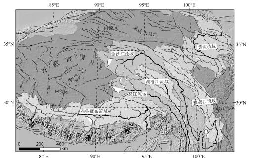 |
| 图1 青藏高原6条大河流域图 |
 |
| 图2 伪洼地处理流程示意图 |
 |
| 图3 伪洼地处理效果对比(雅鲁藏布流域西南边界) |
 |
| 图4 青藏高原6条大河水系不同级别河流的数量N 与河流级别Ω 的关系 |
 |
| 图5 青藏高原6条大河水系不同级别河流的平均长度L 与河流级别Ω 的关系 |
 |
| 图6 青藏高原6条大河水系不同级别河流的平均面积A 与河流级别Ω 的关系 |
 |
| 图7 青藏高原6条大河河网分支比RB 随河流级别Ω 的变化 |
 |
| 表1 金沙江、澜沧江、怒江的最高三级河流数目N 及分支比RB |
 |
| 图8 青藏高原6条大河水系平均河床坡降S 和级别Ω 的关系 |
参考文献:
| [1] Veltri M, Veltri P. On the fractal description of natural channel networks [J]. Journal of Hydrology, 1996, 187(1-2): 137-144. [2] Barbera P L, Rosso R. On the fractal dimentions of stream networks [J]. Water Resources Research, 1989, 25(4): 735-741. [3] David G T, Rafael L B, Ignacio R. The fractal nature of river networks [J]. Water Resources Research, 1988, 24(8): 1317-1322. [4] 吕爱峰, 陈嘻, 王纲胜. 基于DEM的流域水系分维估算方法探讨 [J]. 干旱区地理, 2002, 25(4): 315-320.LV Aifeng, CHEN Xi, WANG Gangsheng, et al. Study on calculation methods of watershed fractal dimension based on DEM [J]. Arid Land Geography, 2002, 25(4): 315-320. (in Chinese) [5] 孙桂凯, 宫兴龙, 莫崇勋, 等. 流域水系分形维数的研究 [J]. 水力发电, 2009, 35 (10): 64-66.SUN Guikuai, GONG Xinglong, MO Chongxun, et al. Study on the calculation method of fractal dimension of river system [J]. Water Power, 2009, 35(10): 64-66. (in Chinese) [6] 姜永清, 邵明安, 李占斌, 等. 黄土高原流域水系的HORTON级比数和分形特性 [J]. 山地学报, 2002, 20(2): 206-211.JIANG Yongqing, SHAO Mingan, LI Zhanbin. Horton's Order Ratios of water course network of drainage basin and their fractal characters in the Loess Plateau [J]. Journal of Mountain Science, 2002, 20(2): 206-211. (in Chinese) [7] Dodds P S, Rothman D H. Scaling, universality, and geomorphology [J]. Annual Review of Earth and Planetary Sciences, 2000, 28: 571-610. [8] Pelletier J D. Self-organization and scaling relationships of evolving river networks [J]. Journal of Geophysical Research, 1999, 104(B4): 7359-7375. [9] Gupta S. Himalayan drainage patterns and the origin of fluvial megafans in the Ganges foreland basin [J]. Geology, 1997, 25(1): 11-14. [10] Walcott R C, Summerfield M A. Universality and variability in basin outlet spacing: Implications for the two-dimensional form of drainage basins [J]. Basin Research, 2009, 21(2), 147-155. [11] Dewey J F, Shackleton R M, Chang C, et al. The tectonic evolution of Tibetan Plateau [J]. Philosophical Transactions of the Royal Society London, 1988, 327(1594): 379-413. [12] Horton R E. Erosional development of streams and their drainage basins: Hydrophysical approach to quantitative morphology [J]. Geological Society of America Bulletin, 1945, 56(3): 275-370. [13] Strahler A N. Quantitative analysis of watershed geomorphology [J]. Transactions of the American Geophysical Union, 1957, 38(6): 913-920. [14] Chorley R J, Morgan M A. Comparison of morphometric features, Unaka Mountains, Tennessee and North Carolina and Dartmoor [J]. England Geological Society of America Bulletin, 1962, 73(1): 17-34. [15] Ciccacci S, D'Alessandro L, Fredi P, et al. Relation between morphometric characteristics and denudation processes in some drainage basins of Italy [J]. Zeitschrift fuer Geomorphologic, 1992, 36(1): 53-67. [16] Kinner D A, Moody J A. Drainage networks after wildfire [J]. International Journal of Sediment Research, 2005, 20(3): 194-201. [17] Stankiewicz J. Fractal river networks of Southern Africa [J]. South African Journal of Geology, 2005, 108(3): 333- 344. [18] Vorosmarty C J, Fekete B M, Meybeck M, et al. Geomorphometric attributes of the global system of rivers at 30 minute spatial resolution [J]. Journal of Hydrology, 2000, 237(1-2): 17-39. [19] Smart J S. Quantitative characterization of channel network structure [J]. Water Resources Research, 1972, 8(6): 1487-1496. [20] Abrahams A D. Channel networks: A geomorphological perspective [J]. Water Resources Research, 1984, 20(2): 161-188. [21] 刘怀湘, 王兆印. 典型河网形态特征与分布 [J]. 水利学报, 2007, 34(11): 1354-1357.LIU Huaixiang, WANG Zhaoyin. Morphological feature and distribution of typical river networks [J]. Journal of Hydraulic Engineering, 2007, 34(11): 1354-1357. (in Chinese) [22] 明庆忠, 史正涛. 三江并流形成时代的初步探讨 [J]. 云南地理环境研究, 2006, 18(4): 1-4.MING Qingzhong, SHI Zhengtao. The tentative inquiry on the formation time in the region of three parallel rivers [J]. Yunnan Geographic Environment Research, 2006, 18(4): 1-4. (in Chinese) [23] 明庆忠. 纵向岭谷北部三江并流区河谷地貌发育及其环境效应研究 [D]. 兰州:兰州大学, 2006.MING Qingzhong. The Landform Development and Environment Effects of Three Parallel Rivers in the North of Longitudinal Range-Gorge Region (LRGR) [D]. Lanzhou: Lanzhou University, 2006. (in Chinese) [24] 张叶春, 李吉均, 朱俊杰, 等. 晚新生代金沙江形成时代与过程研究 [J]. 云南地理环境研究, 1998, 10(2): 43-48.ZHANG Yechun, LI Junji, ZHU Junjie, et al. Studies on development of Jinshajiang River during Late Cenozoic [J]. Yunnan Geographic Environment Research, 1998, 10(2): 43-48. (in Chiness) |
相关文章:
| ||
