 ,1,2,3, ≥Χ≤ΐ–ψ,3,4, “ΕΥΦίΦ3, …ρ ·3, ’≈Κλ5,6
The review and applications of spatial Boltzmann entropy
GAO Peichao,1,2,3, CHENG Changxiu,3,4, YE Sijing3, SHEN Shi3, ZHANG Hong5,6Ά®―ΕΉς’Ώ:
’Ηε»’ΤΎ:2020-03-31–όΜΊ»’ΤΎ:2021-03-25Άχ¬γ≥ωΑφ»’ΤΎ:2021-07-25
| ΜυΫπΉ ÷ζ: |
Received:2020-03-31Revised:2021-03-25Online:2021-07-25
| Fund supported: |
Ής’ΏΦρΫι About authors
ΗΏ≈ύ≥§(1991-), Ρ–, Κ”Ρœ»Υ, Ϋ≤ Π, ÷–ΙζΒΊάμ―ßΜαΜα‘±(S110014357M), ÷ς“Σ¥” ¬–≈œΔΒΊάμ―ß―–ΨΩΓΘE-mail:

’Σ“Σ
ΙΊΦϋ¥ ΘΚ
Abstract
KeywordsΘΚ
PDF (2329KB)‘Σ ΐΨίΕύΈ§Ε»ΤάΦέœύΙΊΈΡ’¬ΒΦ≥ωEndNote|Ris|Bibtex ’≤Ί±ΨΈΡ
±ΨΈΡ“ΐ”ΟΗώ Ϋ
ΗΏ≈ύ≥§, ≥Χ≤ΐ–ψ, “ΕΥΦίΦ, …ρ ·, ’≈Κλ. Ω’Φδ≤ΘΕϊΉ»¬ϋλΊΒΡ―–ΨΩΫχ’Ι”κ”Π”Ο. ΒΊάμ―ß±®[J], 2021, 76(7): 1579-1590 doi:10.11821/dlxb202107001
GAO Peichao, CHENG Changxiu, YE Sijing, SHEN Shi, ZHANG Hong.
1 “ΐ―‘
ΒΊάμ―ßΆ®≥Θ±Μ≥ΤΈΣ «―–ΨΩ άΫγΒΡ―ßΩΤΘ®The World Discipline/SubjectΘ©[1,2],÷Φ‘ΎΆ®ΙΐΉέΚœΤ’ ΒΡΜρΕύΗωΉ®Ο≈ΒΡΕ®¬…ΓΔΡΘ–ΆΓΔ÷Η±ξΒ»ΆΨΨΕά¥ΩΧΜ≠ΚΆάμΫβΒΊ«ρΙΊΦϋ¥χ[3]Θ®¬ΫΒΊ±μ≤ψΓΔΚ”ΝςΚΰ≤¥ΓΔΚΘΑΕ¥χΦΑΫϋΚΘΚΘ”ρΒ»Θ©ΒΡΒΊάμ“ΣΥΊΘ®Αϋά®Ή‘»Μ”κ»ΥΈΡΘ©ΦΑΤδΉέΚœΧεΘ®Φ¥«χ”ρœΒΆ≥Θ©ΒΡ ±Ω’ΗώΨ÷ΓΔ―ί±δΙΐ≥ΧΓΔΕ·ΝΠΜζ÷Τ[4,5,6,7]ΓΘ’β–©ΆΨΨΕ”–÷χΟϊΒΡΒΊάμ―ß»ΐ¥σΕ®¬…ΓΔΒΊάμΦ”»®ΜΊΙιΓΔΒΊάμΧΫ≤βΤς[8]Β»ΓΘλΊΉςΈΣ»»ΝΠ―ß÷–Ϋβ“κ άΫγ±δΜ·ΒΡΙΛΨΏ,“≤≥ΛΤΎ‘ΎΒΊάμ―ß÷–Αγ―ίΉ≈÷Ί“ΣΫ«…ΪΓΘλΊ «Η¥‘”œΒΆ≥ΒΡΚΥ–Ρ÷Η±ξ,ΕχΒΊάμ―ßΒΡ–¬ ±¥ζΧΊ’ς «Η¥‘”–‘[9,10],“ρ¥ΥλΊΒΡ―–ΨΩ”ζΖΔΒΟΒΫ÷Ί ”,Ε‘–¬ ±¥ζΒΊάμ―ß“β“ε÷Ί¥σΓΘΒ±«Α,λΊ‘ΎΒΊάμ―ß÷–÷ς“Σ”–ΝΫ¥σ”ΟΆΨΓΘ Ήœ»,λΊ±Μ”Ο”ΎΙΊΝΣΒΊάμ―ß―–ΨΩΕ‘œσΒΡ ±Ω’±δΜ·±μ’ς”κ…ν≤ψ¥ΈΒΡ»»ΝΠ―ßΜζάμΓΘ»»ΝΠ―ß÷–»œΈΣ,Ζβ±’œΒΆ≥ΒΡλΊΉ‘ΖΔΒΊΓΔ≤ΜΩ…ΡφΉΣΒΊΫΞ‘ω÷ΝΉν¥σ÷ΒΓΘ’β’ΐ «÷χΟϊΒΡ»»ΝΠ―ßΒΎΕΰΕ®¬…Θ®”÷≥ΤλΊΕ®¬…Θ©ΓΘΆ§ ±,λΊ”κ»»ΝΠ―ßΈό–ρΚΆœΒΆ≥≤Μ»ΖΕ®–‘”–Ή≈ΫτΟήΒΡΡΎ‘ΎΝΣœΒΓΘ“ρ¥Υ,λΊΉςΈΣΝΣœΒ»»ΝΠ―ßΜζάμΒΡ“«≈ΝΚ”,±Μ≥ΛΤΎΓΔΙψΖΚΒΊ”Π”Ο”ΎΒΊάμœΒΆ≥Θ®Αϋά®Ή‘»ΜΓΔ»ΥΈΡœΒΆ≥ΓΔΦΑΤδώνΚœœΒΆ≥Θ©ΒΡ―–ΨΩ÷–ΓΘάΐ»γ,’κΕ‘ΨΑΙέΗώΨ÷ΒΡ”Π”ΟΩ…ΉΖΥί÷Ν20 άΦΆ50Ρξ¥ζ,≤Δ–Έ≥…ΝΥ»ΐ¥σΖΫœρΘΚΩΧΜ≠ΨΑΙέΗώΨ÷ΒΡΩ’Φδ“λ÷ –‘ΓΔ≥ΏΕ»“άάΒ–‘ΓΔ≤ΜΩ…‘Λ≤β–‘[11]ΓΘ”÷»γ,―ß θΫγ ‘ΆΦ¥”»»ΝΠ―ß±Ψ÷ …œάμΫβœΒΆ≥Ω…≥÷–χ–‘ΚΆ«χ”ρΩ…≥÷–χΖΔ’Ι,“ρ¥ΥλΊ“≤”Ο”ΎΙΙΫ®Ω…≥÷–χ/ΗΏ÷ ΝΩΖΔ’Ι÷Η ΐ[12]ΓΔ”Ο”ΎΤάΙάΚΆ÷ΗΒΦ≥« –Ϋ®…η[13]ΓΘΤδ¥Έ,λΊΉςΈΣ–≈œΔΝΩΒΡ≤βΕ»÷Η±ξ,±ΜΙψΖΚΒΊ”Π”Ο”ΎΒΊΆΦ÷ΤΆΦ―ßΓΔΒΊάμ–≈œΔΩΤ―ß”κœΒΆ≥ΓΔ“ΘΗ–ΆΦœώ¥ΠάμΒ»Νλ”ρΓΘάΐ»γ,λΊ±Μ”Ο”Ύ≤βΕ»ΒΊΆΦΒΡ–≈œΔΝΩ[14],ΫχΕχΕ‘÷ΤΆΦΉέΚœΫχ––÷ΗΒΦ[15]ΓΘ“‘λΊΈΣΚΥ–Ρ,ΒΊΆΦ÷ΤΆΦ―ßΖΔ’Ι≥ωΒΊΆΦ–≈œΔ¬έ[16]ΒΡΖ÷÷ß―ßΩΤΓΘ‘Ύ“ΘΗ–ΆΦœώ¥ΠάμΝλ”ρ,λΊΉςΈΣΚβΝΩΆΦœώ–≈œΔΝΩΒΡ±ξΉΦ÷Η±ξ[17],±Μ”Ο”ΎΫΒΈ§[18]ΓΔ»ΎΚœ[19]ΓΔ≈δΉΦ[20]ΓΔΖ÷Ην[21]Β»ΓΘ
ΨΓΙήλΊ «‘¥Ή‘»»ΝΠ―ßΒΡΗ≈Ρν,ΒΪ‘Ύ…œ ω”Π”Ο÷–ΒΡΦΤΥψΖΫΖ®»¥ΦΗΚθΆξ»Ϊά¥Ή‘Ά®–≈Νλ”ρΒΡ–≈œΔ¬έΓΘΨΏΧεΕχ―‘,“λΊ”ΒΡΗ≈Ρν «1851Ρξ”…Β¬ΙζΩΤ―ßΦ“Clausius Ή¥Έ“ΐ»κ[22],≤Δ”Ύ1872Ρξ”…Α¬ΒΊάϊΈοάμ―ßΦ“Boltzmann Ή¥Έ Ι”ΟΙΪ ΫΟς»ΖΒΊ±μ¥οΘ®Φ¥≤ΘΕϊΉ»¬ϋλΊΓΔΦρ≥Τ≤ΘλΊΜρ≥Τ»»ΝΠ―ßλΊΘ©[23]ΓΘ20 άΦΆ40Ρξ¥ζ Φ¥¥ΒΡ–≈œΔ¬έ÷–‘Ό¥Έ Ι”ΟΝΥ“λΊ”ΒΡΗ≈Ρν,≤Δ”Ύ1948Ρξ”…ΟάΙζ ΐ―ßΦ“ShannonΧα≥ωΦΤΥψΙΪ ΫΘ®Φ¥œψ≈©λΊΓΔ–≈œΔλΊΘ©[24]ΓΘœψ≈©λΊΒΡΙΪ ΫΦρΫύΓΔ±δΝΩΚ§“εΟς»Ζ«“»ί“Ή≤βΕ®ΓΘœύ±»÷°œ¬,≤ΘλΊΒΡΦΤΥψάßΡ―÷Ί÷ΊΓΘ≤ΜΙΐ,Εύ ΐ****»œΈΣ2÷÷λΊ±Ψ÷ œύΆ§ΓΔ ΐ÷ΒΩ…ΜΞΜΜ[25]ΓΘ“ρ¥Υ,‘Ύ…œ ωΝΫ¥σ”Π”Ο÷–,άμ¬έΧΫΧ÷ ±Μρ≤…”Ο≤ΘλΊΜρ≤…”Οœψ≈©λΊ,ΒΪ ΒΦ ΦΤΥψ ±Ψυ≤…”ΟΝΥœψ≈©λΊΥψΖ®ΓΘ
»ΜΕχ,œψ≈©λΊΒΡ Ι”Ο¥χά¥ΝΥΡ―“‘ΫβΨωΒΡάßΨ≥ΓΘ Ήœ»,Ά®Ιΐœψ≈©λΊΕχΜώΒΟΒΡ»»ΝΠ―ßΫβ“κ‘ΎΫϋΡξά¥±Μ―œ÷Ί÷ “…ΓΘάΐ»γ,VrankenΒ»****[11]ΖΔœ÷ΘΚΜυ”Ύœψ≈©λΊ≤βΕ®ΒΡΩ’Φδ“λ÷ –‘”κ»»ΝΠ―ßΚΝΈόΙΊΝΣΓΔœψ≈©λΊ≥ΏΕ»“άάΒ–‘ΒΡ»»ΝΠ―ßΫβ Ά”κΗ¥‘”άμ¬έœύψΘΓΔΜυ”Ύœψ≈©λΊΒΡ≤ΜΩ…‘Λ≤β–‘÷Μ‘ΎΧΊΕ®ΧθΦΰœ¬”κ»»ΝΠ―ß”–ΙΊΓΘΟάΙζΒΊάμ―ßΦ“CushmanΫΪ’β–©ΖΔœ÷Τά¬έΈΣ“Νν»Υ’πΨΣ”ΒΡ,≤ΔΚτ”θ÷ΊΖΒ≤ΘλΊ[26]ΓΘΤδ¥Έ,œψ≈©λΊΈόΖ®Άξ’ϊΒΊΩΧΜ≠Ω’Φδ ΐΨίΒΡ–≈œΔΝΩΘ®ΜρΈό–ρΘ©ΓΘœψ≈©λΊΒΡ…ηΦΤ≥θ÷‘ΈΣΩΧΜ≠Ά®―Ε–≈Κ≈Θ®άΐ»γΒγ±®Θ©ΒΡ–≈œΔΝΩ,ΫωΩΦ¬«ΝΥ–≈Κ≈÷–≤ΜΆ§≥…Ζ÷ΒΡ’Φ±»Θ®Μρ≥ΤΈΣ–≈‘¥≤ζ…ζΗΟ≥…Ζ÷ΒΡΗ≈¬ Θ©,“ρ¥Υ“≤±ΜΙψΖΚΒΊ≥ΤΈΣΆ≥ΦΤ–≈œΔΝΩΓΘ‘ΎΫωΩΦ¬«Ά≥ΦΤ–≈œΔ ±,œψ≈©λΊΚΆ≤ΘλΊ¥φ‘Ύ ΐ÷ΒΉΣΜΜΒΡΩ…Ρή–‘ΓΘΕχΩ’Φδ ΐΨίΒΡ–≈œΔΝΩ≤ΜΫω‘Ύ”Ύ≥…Ζ÷ΒΡ’Φ±»,Ηϋ‘Ύ”ΎΉιΖ÷ΚΆ≈δ÷ΟΓΘΨΓΙή―ß θΫγΕ‘œψ≈©λΊΥψΖ®Ήω≥ωΝΥΕύ÷÷ΗΡΫχ[27],ΒΪ“ά»Μ–ßΙϊ«ΖΦ―ΓΘ“ρ¥Υ,‘Ϋά¥‘ΫΕύΒΡ****»œΈΣ2÷÷λΊΨΏ”–±Ψ÷ ΒΡ≤ΜΆ§ΓΘΨΑΙέ…ζΧ§―ßΫγ»œΈΣ,2÷÷λΊΫω «–Έ ΫœύΥΤ[11, 28],…ζΈο―ßΫγ[29]ΚΆΈοάμ―ßΫγ[30]Ψυ”–άύΥΤΙέΒψΓΘ ΒΦ …œ,Shannon±Ψ»Υ“≤‘χΟς»ΖΤδλΊ≤ΔΖ«ΆΤΒΦΉ‘≤ΘλΊ[31],2÷÷λΊΫω‘ΎΧΊΕ®ΧθΦΰœ¬≤≈Ω…ΜΞΉΣ[32]ΓΘ
“ρΈΣ…œ ωάßΨ≥ΚΆ–¬ΒΡ»œ Ε,ΉνΫϋ5Ρξ―ß θΫγ÷Ί–¬ΨέΫΙ”ΎΙ≈άœΒΡ≤ΘλΊ,Φϊ÷ΛΝΥΤδ≥ΛΉψΒΡΫχ≤Ϋ, Βœ÷ΝΥΉ‘1872Ρξ≤ΘλΊΒΡΗ≈ΡνΧα≥ωΚσ’κΕ‘Ω’Φδ ΐΨίΒΡ Ή¥ΈΦΤΥψ,≤Δ–Έ≥… ΒΦ ”Π”ΟΓΘ±ΨΈΡΫΪ¥”Η≈ΡνΓΔΡΘ–ΆΓΔΦΤΥψΓΔ”Π”Ο4ΗωΖΫΟφΕ‘’β–©Ϋχ’ΙΫχ––œΒΆ≥ΒΡΉέ ωΓΘ
2 ≤ΘλΊΒΡΗ≈ΡνΡΘ–Ά”κΦΤΥψΡ―Χβ
≤ΘλΊ…φΦΑΝΫ¥σΗ≈ΡνΘΚœΒΆ≥ΒΡΚξΙέΧ§Θ®MacrostateΘ©ΚΆΈΔΙέΧ§Θ®MicrostateΘ©ΓΘ«Α’Ώ÷ΗœΒΆ≥Ή¥Χ§ΒΡΚξΙέΟη ω,Ά®≥Θ Ι”Ο»τΗ…Ω…ΝΩ≤βΒΡΚξΙέΧΊ–‘Θ®≥ΤΈΣΉ¥Χ§Κ· ΐΓΔΚξΙέ≤Έ ΐ,»γ―Ι«ΩΓΔΧεΜΐΓΔΈ¬Ε»Θ©ά¥ Βœ÷[33]ΓΘΚσ’Ώ÷Η¥”ΈΔΙέΒΡΫ«Ε»ΩΧΜ≠œΒΆ≥ΒΡΡΎ≤ΩœΗΫΎΘ®»γΉιΖ÷ΈΜ÷ΟΘ©ΓΘ»γ‘ΎΆΦ1Υυ ΨΒΡΖβ±’œΒΆ≥÷–,ΚξΙέΧ§ΨυΈΣ“»ίΤς÷–”–3ΗωΤχΧεΖ÷Ή””,ΈΔΙέΧ§»¥≤ΜΨΓœύΆ§ΓΘΆΦ1
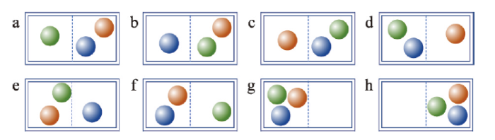 –¬¥ΑΩΎ¥ρΩΣ|œ¬‘Ί‘≠ΆΦZIP|…ζ≥…PPT
ΆΦ1ΚξΙέΧ§ΈΣΡΎΚ§3Ηω≤ΜΆ§άύ–ΆΤχΧεΖ÷Ή”ΒΡΟή±’»ίΤςΦΑΤδ8÷÷ΈΔΙέΧ§
Fig. 1A closed container and its 8 microstates (macrostate: it contains three gas molecules)
‘ΎΚξΓΔΈΔΙέΧ§Η≈ΡνΒΡΜυ¥Γ…œ,≤ΘΕϊΉ»¬ϋΧα≥ωΝΥ≤ΘλΊΒΡΗ≈ΡνΡΘ–ΆΘ®≤ΘΕϊΉ»¬ϋΙΪ ΫΘ©ΘΚ
Ϋ÷–ΘΚSΦ¥œΒΆ≥ΒΡ≤ΘλΊ;W «ΚξΙέΧ§ΥυΕ‘”ΠΈΔΙέΧ§ΒΡΗω ΐ;kB «≤ΘΕϊΉ»¬ϋ≥Θ ΐ»Γ÷ΒΈΣ1.3807×10⁻²³ J/KΓΘΆΦ1÷–Υυ ΨΒΡΟή±’»ίΤςΨΏ”–8÷÷ΈΔΙέΧ§,“ρ¥Υ≤ΘλΊΈΣkB log8ΓΘ
≤ΘΕϊΉ»¬ϋΙΪ ΫΦρΫύ,ΒΪΤδ‘ΎΒΊάμ―ß÷–ΒΡ”Π”Ο≥ΛΤΎΆΘΝτ‘ΎΧΫΧ÷≤ψΟφ[11, 26]ΓΘ”Π”ΟΤΩΨ±‘Ύ”ΎΦΤΥψάßΡ―,ΨΏΧε‘≠“ρ”–ΘΚΔΌ »±…ΌΆ®”ΟΓΔΤ’ ΒΡΚξΙέΧ§Ε®“εΖΫΖ®,»γΟάΙζ…γΜα―ßΦ“BaileyΥυ―‘“≤ΘλΊΨΓΙή÷Ί“Σ,ΒΪΈοάμ―ßΝλ”ρΆβΒΡ****»±…ΌΚξΙέΧ§ΒΡΕ®“εΖΫΖ®,άΐ»γ,»γΚΈΕ®“ε“ΜΩιΨΑΙέΗώΨ÷ΒΡΚξΙέΧ§?”[34]ΔΎ Φ¥±ψΚξΙέΧ§”–ΝΥΝΦΚΟΒΡΕ®“ε,ΈΔΙέΧ§ ΐΒΡ Β―ι≤βΕ®“ύΡ― Βœ÷,άμ¬έΆΤΒΦ»±…ΌΖΫΖ®[35]ΓΘ
3 Ω’Φδ≤ΘλΊΒΡΦΤΥψΡΘ–Ά
2016ΡξΤπ,―ß θΫγ‘ΎΩ’Φδ ΐΨίΒΡ≤ΘλΊ―–ΨΩΖΫΟφ»ΓΒΟΝΥœΒΝ–Ϋχ’ΙΓΘ Ή“ΣΫχ’ΙΈΣΦΤΥψΡΘ–Ά Βœ÷ΝΥΩ’Φδ≤ΘλΊΦΤΥψΡΘ–Ά¥”ΈόΒΫ”–ΒΡΆΜΤΤΘ®Ι≤ΦΤ2άύ3÷÷Θ©ΓΘ2άύΦΤΥψΡΘ–ΆΖ÷±π ”Ο”ΎΕ®–‘–ΆΚΆΕ®ΝΩ–Ά’ΛΗώ ΐΨίΓΘΕ®–‘–Ά «÷Η“‘’ΛΗώ–Έ Ϋ¥φ¥ΔΒΡάύ±π–ΆΩ’Φδ ΐΨί,Ω…œΗΖ÷ΈΣΟϊ“ε–ΆΚΆ¥Έ–ρ–ΆΓΘΟϊ“ε–Ά÷–≤ΜΆ§άύ±πΈόΥ≥–ρ÷°Ζ÷,άΐ»γΆΝΒΊάϊ”Ο/Η≤Η«άύ–ΆΆΦΓΔΨΑΙέœβ«ΕΧε;¥Έ–ρ–Ά÷–≤ΜΆ§άύ±π”–Υ≥–ρ÷°Ζ÷,άΐ»γ“Ώ«ιΖγœ’Β»ΦΕΒΊΆΦΓΘΕ®ΝΩ–Ά «“‘’ΛΗώ–Έ Ϋ¥φ¥ΔΒΡΝ§–χ–ΆΩ’Φδ ΐΨί,Αϋά®ΦδΗτ–ΆΚΆ±»¬ –Ά2άύΓΘ«Α’Ώ»γΒΊ±μ…ψ œΈ¬Ε»ΧίΕ»,Κσ’Ώ»γ ΐΉ÷ΗΏ≥ΧΡΘ–ΆΓΘ”κ«Α’Ώœύ±»,Κσ’Ώ÷ß≥÷≥Υ≥ΐ‘ΥΥψ,ΒΪ « ΒΦ ”Π”Ο÷–ΆυΆυ≤Μ―œΗώ«χΖ÷Εΰ’Ώ,‘ΎΒΊάμ―ßΘ®”»ΤδΨΑΙέ…ζΧ§―ßΘ©÷–Ά®≥ΘΫΪΕΰ’ΏΚœ≤ΔΆ≥≥ΤΈΣΨΑΙέΧίΕ»[36]ΓΘ
3.1 ’κΕ‘Ε®–‘–Ά’ΛΗώ ΐΨίΒΡΦΤΥψΡΘ–Ά
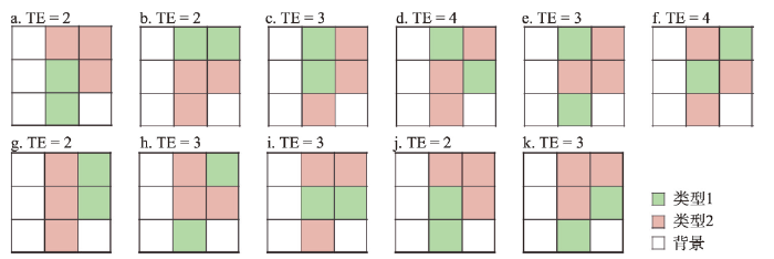
Ω’Φδ≤ΘλΊΒΡΦΤΥψΥΦœκΉν‘γ «’κΕ‘Ε®–‘–Ά’ΛΗώ ΐΨίΧα≥ωΒΡΓΘ2016ΡξCushmanΆ®Ιΐάύ±»»»ΝΠ―ß÷–ΒΡΥψάΐ, Ή¥ΈΧα≥ωΝΥ’κΕ‘ΨΑΙέœβ«ΕΧεΒΡ≤ΘλΊΦΤΥψΥΦœκ——Μυ”Ύ±Ώ‘ΒΉή≥ΛΕ»Θ®ΨΑΙέΗώΨ÷÷Η ΐTotal Edge, TEΘ©ΒΡΦΤΥψΡΘ–Ά[37]ΓΘΗΟΡΘ–Ά Ι”ΟΝΥ5œνΘ®ΉιΘ©ΚξΙέ≤Έ ΐ,Ζ÷±π «ΦΗΚΈΖΕΈßΓΔœΗΑϊΘ®ΨΑΙέœβ«ΕΧεΒΡΜυ±ΨΒΞ‘ΣΘ©ΒΡάύ–Ά ΐΓΔΗςάύ–ΆΒΡ’Φ±»ΓΔΖ÷±φ¬ Θ®ΜρœΗΑϊΉή ΐΘ©ΓΔTEΓΘΈΔΙέΧ§Ε®“εΈΣœΗΑϊΒΡΩ’Φδ≈δ÷Ο,Ηω ΐΆ®Ιΐ«νΨΌΖ®ΜώΒΟΓΘ“‘ΆΦ2a÷–ΒΡΨΑΙέœβ«ΕΧεΈΣάΐ,ΤδΦΗΚΈΖΕΈßΈΣ¬Χ…ΪΚΆΖέΚλ…Ϊ«χ”ρ,Ι≤”–2άύΓΔ5ΗωœΗΑϊΓΘΤδ÷–άύ–Ά1ΒΡœΗΑϊ”–2ΗωΓΔάύ–Ά2”–3Ηω,±Ώ‘ΒΉή≥ΛΕ»ΈΣ2ΓΘΈΔΙέΧ§ΒΡ«νΨΌΙΐ≥Χ»γœ¬ΘΚ Ήœ»,‘Ύ±Θ≥÷≥ΐTEΆβΒΡΥυ”–ΚξΙέ≤Έ ΐ≤Μ±δΒΡΧθΦΰœ¬,«νΨΌœΗΑϊΒΡΩ’Φδ≈δ÷ΟΖΫ Ϋ,»γΆΦ2b~2kΥυ ΨΓΘ»ΜΚσ,Ά≥ΦΤ”κ‘≠ΨΑΙέœβ«ΕΧεΨΏ”–œύΆ§TEΒΡ«νΨΌΫαΙϊΗω ΐ,¥Υ¥ΠΈΣ3ΓΘ¥ΥΗω ΐΦ¥ΈΔΙέΧ§ ΐ,Ω…¥ζ»κ≤ΘΕϊΉ»¬ϋΙΪ Ϋ«σΫβ≤ΘλΊ,ΒΟΒΫ
ΆΦ2
 –¬¥ΑΩΎ¥ρΩΣ|œ¬‘Ί‘≠ΆΦZIP|…ζ≥…PPT
ΆΦ2ΨΑΙέœβ«ΕΧε(a)ΓΔΩ…ΡήΒΡΩ’Φδ≈δ÷ΟΖΫ Ϋ(b~k)ΦΑΤδ±Ώ‘ΒΉή≥ΛΕ»(TE)
Fig. 2A landscape mosaic (a), possible configurations (b-k), and the corresponding total edges (TE)
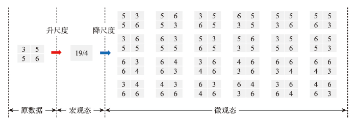
ΗΟΦΤΥψΡΘ–ΆΒΡ”≈Βψ «ΚξΙέΧ§ΒΡΕ®“εΕ‘Υυ”–Ε®–‘–Ά’ΛΗώ ΐΨίΨΏ”–Τ’ –‘,ΚξΙέ≤Έ ΐΨυΩ…ΩλΫίΒΊΦΤΥψΓΘΤδ»±Βψ «,ΈΔΙέΧ§ ΐΒΡΦΤΥψΖΫΖ®»±ΖΠΩ…≤Ό–‘ΓΘ‘Ύ’ΛΗώ ΐΨίΒΡ≥Ώ¥γΫœ¥σ ±,«νΨΌΫαΙϊ ΐΩ…Ρή «ΧλΈΡ ΐΉ÷ΓΘάΐ»γ,…η’ΛΗώ ΐΨίΒΡ¥σ–ΓΫωΈΣ100––100Ν–,«“ΫωΑϋά®2άύΓΔΟΩάύΗω ΐœύΆ§ΒΡœΗΑϊ,‘ρ«νΨΌΫαΙϊΒΡάμ¬έΗω ΐΗΏ¥ο
ΒΎΕΰ÷÷ΦΤΥψΥΦœκΈΣΜυ”ΎΑΏΩιΒΡΦΤΥψΡΘ–Ά,”…÷–Ιζ****”Ύ2019ΡξΧα≥ω[38]ΓΘ Ήœ»,ΚξΙέ≤Έ ΐ±Μ ‘―ι–‘ΒΊ…η÷ΟΈΣ’ΛΗώ ΐΨίΒΡœΗΑϊΉή ΐN“‘ΦΑΗςάύ–ΆœΗΑϊΒΡΨΏΧεΗω ΐNiΓΘ‘Ύ¥Υ«ιΩωœ¬,ΈΔΙέΧ§ ΐΒΡΦΤΥψΩ…Ά®Ιΐ ΐ―ß…œΒΡ≈≈Ν–ΉιΚœΙΪ ΫΆξ≥…ΘΚ
Ϋ÷–ΘΚmΈΣάύ–Ά ΐΓΘΫΪΗΟΈΔΙέΧ§ ΐ¥χ»κ≤ΘλΊΙΪ Ϋ≤ΔΜ·Φρ,ΒΟΒΫΘΚ
»ΜΕχ,’β÷÷ΖΫ ΫΕ®“εœ¬ΒΡ≤ΘλΊ,÷ΜΡήΩΧΜ≠’ΛΗώ ΐΨίΒΡΉιΖ÷ΓΔΈόΖ®ΩΧΜ≠≈δ÷ΟΓΘ“ρ¥Υ,ZhaoΒ»[38]‘ωΦ”ΝΥΕ‘ΆΊΤΥΙΊœΒΒΡΩΦ¬«,ΫΪΦΤΥψΡΘ–Ά–ό’ΐΈΣΘΚ
Ϋ÷–ΘΚniΈΣάύ–ΆiΒΡœΗΑϊœύΜΞ÷°ΦδΥυ–Έ≥…ΒΡΑΏΩι ΐΘ®œΗΑϊ‘Ύ…œœ¬Ήσ”“ΒΡ»Έ“ΜΖΫœρœύΝ§–Έ≥…ΑΏΩιΘ©;kijΈΣάύ–ΆiΒΡœΗΑϊΥυ–Έ≥…ΒΡΒΎjΗωΑΏΩι÷–ΥυΑϋΚ§ΒΡœΗΑϊ ΐΓΘ
ΗΟ–ό’ΐΑφ‘Ύ±ΨΈΡ÷–±ΜΟϋΟϊΈΣΜυ”ΎΑΏΩιΒΡΦΤΥψΡΘ–Ά,Τδ”≈Βψ «ΨΏ”–ΫβΈω–Έ Ϋ,»±Βψ”–ΘΚΔΌ –ό’ΐ÷°ΚσΒΡΦΤΥψΡΘ–ΆΥυΕ‘”ΠΒΡΚξΙέΧ§Ε®“ε≤ΜΟς»Ζ;ΔΎ ‘Ύ ΒΦ ΦΤΥψ÷–»ί“Ή“ρ ΐ÷ΒΫœ¥σΒΡΫΉ≥Υ‘ΥΥψ≤ζ…ζ ΐ÷Β“γ≥ωΒΡΈ Χβ,»γΦΌ…η’ΛΗώ ΐΨίΒΡ¥σ–ΓΫωΈΣ10––10Ν–,ΙΪ ΫΘ®4Θ©÷– Ήœν÷–Αϋά®ΒΡΫΉ≥Υ ΐ÷ΒΗΏ¥ο9.3326×10157ΓΘ
3.2 ’κΕ‘Ε®ΝΩ–Ά’ΛΗώ ΐΨίΒΡΦΤΥψΡΘ–Ά
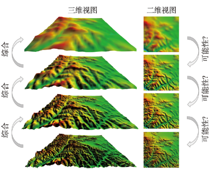
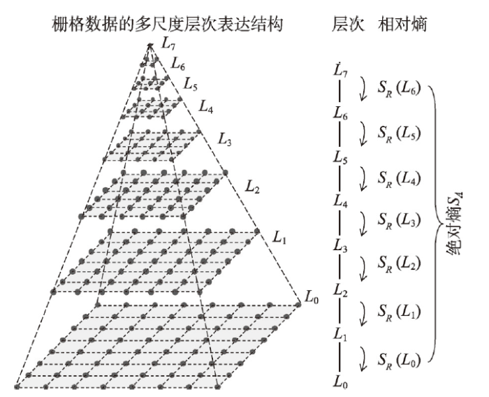
’κΕ‘Ε®ΝΩ–Ά’ΛΗώ ΐΨίΒΡΦΤΥψΡΘ–Ά”Ύ2017ΡξΧα≥ω[39],ΤδΚΥ–ΡΥΦœκ «Ά®Ιΐ≥ΏΕ»±δΜΜΫ®ΝΔΚξΙέΧ§”κΈΔΙέΧ§÷°ΦδΒΡΝΣœΒΓΘΗΟΡΘ–Ά»œΈΣΥυ”–ΒΡΕ®ΝΩ–Ά’ΛΗώ ΐΨίΨυ”–Τ’ ΒΡΚξΙέΧ§Ε®“ε,Φ¥’ΛΗώ ΐΨίΒΡΕύ≥ΏΕ»±μ¥οΘ®ΆΦ3Θ©ΓΘΆ§ ±»œΈΣ,‘Ύ»»ΝΠ―ß÷–ΈΔΙέΧ§Ρ―“‘≤βΕ®ΒΡ±Ψ÷ ‘≠“ρ «Ιέ≤β≥ΏΕ»Ω…“‘ΈόœόœΗΖ÷,¥”ΕχΒΦ÷¬Έό«νΨΓΓΘΒΪΕ‘”Ύ’ΛΗώ ΐΨίΕχ―‘,Τδ‘≠Ζ÷±φ¬ Φ¥ΈΣΉνΧλ»ΜΒΡΙέ≤β≥ΏΕ»,“ρ¥ΥœόΕ®ΝΥΈΔΙέΧ§ΒΡ ΐΝΩ, ΙΤδ≤βΕ®≥…ΈΣΩ…ΡήΓΘΆΦ3
 –¬¥ΑΩΎ¥ρΩΣ|œ¬‘Ί‘≠ΆΦZIP|…ζ≥…PPT
ΆΦ3Ε®ΝΩ–ΆΩ’Φδ’ΛΗώ ΐΨίΒΡΕύ≥ΏΕ»≤ψ¥Έ±μ¥οΫαΙΙ
Fig. 3The multiscale hierarchy of a quantitative spatial raster data
ΨΏΧεΕχ―‘,Ε®ΝΩ–Ά’ΛΗώ ΐΨίΒΡΚξΙέΧ§Ε®“εΈΣΤδΕύ≥ΏΕ»≤ψ¥Έ±μ¥οΫαΙΙ÷–”κ‘≠±μ¥οΉνœύΥΤΒΡ≤ψ¥ΈΓΘΕύ≥ΏΕ»≤ψ¥Έ±μ¥οΫαΙΙΆ®Ιΐ÷ΤΆΦΉέΚœ÷–ΒΡ…ΐ≥ΏΕ»Θ®Up-scalingΘ©≤ΌΉςΜώΒΟΓΘΈΣΝΥ Ι≤ψ¥ΈΨΓΩ…ΡήΒΟΖαΗΜ,…ΐ≥ΏΕ»≤ΌΉς÷–≤…”Ο¥σ–ΓΈΣ
ΆΦ4
 –¬¥ΑΩΎ¥ρΩΣ|œ¬‘Ί‘≠ΆΦZIP|…ζ≥…PPT
ΆΦ4’κΕ‘Ε®ΝΩ–ΆΩ’Φδ’ΛΗώ ΐΨίΦΤΥψ≤ΘλΊΒΡΚΥ–ΡΥΦœκ
Fig. 4The core idea in computing the Boltzmann entropy of a quantitative spatial raster data
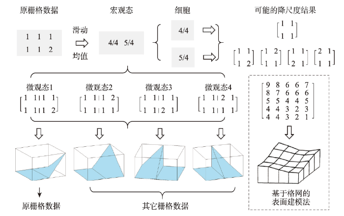
¥ΥΆβ,ΗΟΡΘ–Ά“ΐ»κΝΥœύΕ‘ΚΆΨχΕ‘≤ΘλΊΒΡΗ≈ΡνΓΘΫΪ…œ ωΈΔΙέΧ§ ΐ÷±Ϋ”¥ζ»κΙΪ ΫΘ®1Θ©ΒΟΒΫΒΡΫαΙϊ≥ΤΈΣœύΕ‘≤ΘλΊ,“ρΤδΩΧΜ≠ΒΡ «’ΛΗώ ΐΨίœύΕ‘”ΎΤδΚξΙέΧ§ΒΡ≤Μ»ΖΕ®–‘ΓΘ‘ΎΕύ≥ΏΕ»≤ψ¥Έ±μ¥οΫαΙΙ÷–,œύΕ‘λΊΩ…‘Ύ»Έ“βœύΝΎΒΡΝΫ≤ψΦδΦΤΥψΘ®ΆΦ5Θ©,Υυ”–≤ψΒΡœύΕ‘λΊ÷°ΚΆ≥ΤΈΣΨχΕ‘≤ΘλΊΓΘΤδΚ§“εΈΣ,¥”’ΛΗώ ΐΨίΒΡΉν≥ιœσΉ¥Χ§÷π≤ψΫΒ≥ΏΕ»ΒΫ‘≠’ΛΗώ ΐΨίΒΡΩ…Ρή–‘¥σ–Γ;ΜΜ―‘÷°,’ΛΗώ ΐΨίœύΕ‘”ΎΉν≥ιœσΒΡΉ¥Χ§Θ®≤Μ»ΖΕ®–‘ΈΣΝψΘ©ΒΡ≤Μ»ΖΕ®–‘ΓΘ
ΆΦ5
 –¬¥ΑΩΎ¥ρΩΣ|œ¬‘Ί‘≠ΆΦZIP|…ζ≥…PPT
ΆΦ5œύΕ‘≤ΘλΊ(SR)”κΨχΕ‘≤ΘλΊ(SA)
Fig. 5Relative (SR) and absolute (SA) Boltzmann entropies
4 Ω’Φδ≤ΘλΊΒΡΥψΖ®
“‘…œ ω3÷÷ΡΘ–ΆΈΣάΕ±Ψ,―ß θΫγΖ÷±πΖΔ’ΙΝΥ3άύΨΏΧεΒΡΦΤΥψΆΨΨΕΘΚΜυ”ΎTEΒΡΥψΖ®[37, 40]ΓΔΜυ”ΎWassersteinΨύάκΒΡΥψΖ®[38, 41]ΓΔΜυ”ΎΕύ≥ΏΕ»≤ψ¥ΈΒΡΥψΖ®[39, 41-45]ΓΘ‘Ύ Βœ÷Ιΐ≥Χ÷–,”…”ΎΦΦ θΩΦ¬«,”––©ΥψΖ®…θ÷Ν“―Ψ≠Ά―άκΝΥ‘≠ΡΘ–ΆΒΡΚΥ–ΡΥΦœκΓΘ4.1 Μυ”ΎTEΒΡΥψΖ®
Βœ÷TEΦΤΥψΡΘ–ΆάßΡ―ΒΡΙΊΦϋ‘Ύ”Ύ«νΨΌ ΐΨί«ςΫϋ”ΎΈό«ν¥σ,Ρ―“‘ΜώΒΟ«νΨΌΫαΙϊΒΡΦ·ΚœΘ®Φ¥Ά≥ΦΤ―ß÷–ΒΡ’ϊΧεΘ©ΓΘ“ρ¥Υ,Cushman[40]Χα≥ω Ι”Ο―υ±ΨΦ·¥ζΧφ’ϊΧεΘΚ≤Μ‘Ό≤βΕ®’ϊΧε÷–ΨΏ”–ΗχΕ®TEΒΡΗωΧε ΐΘ®WΘ©,Εχ «Ά®Ιΐ≤βΕ®―υ±ΨΦ·÷–ΨΏ”–ΗχΕ®TEΒΡΗωΧε’Φ±»ά¥ΙάΥψΦΌ…η’ΛΗώ ΐΨίΒΡ––Ν– ΐΖ÷±πΈΣ
‘ΎΜώΒΟ…œ ω―υ±ΨΦ·Κσ,–ηΆ≥ΦΤ”κ‘≠’ΛΗώ ΐΨί”Β”–œύΆ§TEΒΡ―υ±ΨΗω ΐ,≤ΔΉν÷’ΫΪΗω ΐΉΣΜΜΈΣ’Φ±»Θ®
ΉΔ“β
Μυ±ΨΥψΖ®÷–≤…”Ο―υ±ΨΦ·¥ζΧφΝΥ’ϊΧε,ΫΒΒΆΝΥ«νΨΌΒΡΡ―Ε»,ΒΪ‘Ύ’ΛΗώ ΐΨί≥Ώ¥γΫœ¥σ ±«νΨΌ“ά»ΜάßΡ―ΓΘCushman‘Ύ¥Πάμ≥Ώ¥γΈΣ
Ϋ÷–ΘΚ
4.2 Μυ”ΎWassersteinΨύάκΒΡΥψΖ®
Μυ”ΎΑΏΩιΒΡΦΤΥψΡΘ–Ά¥φ‘ΎΫΉ≥Υ‘ΥΥψ ΐ÷Β“γ≥ωΒΡΈ ΧβΘ®3.1ΫΎΘ©,Ρ―“‘ΦΦ θ Βœ÷ΓΘΈΣΫβΨωΗΟΈ Χβ,ZhaoΒ»Χα≥ωΝΥΜυ”ΎWassersteinΨύάκΒΡΥψΖ®[38]ΓΘΨΏΧεΥψΖ®»γœ¬ΘΚ Ήœ»,…αΤζΙΪ ΫΘ®4Θ©÷–ΒΡ Ήœν,Ϋω Ι”ΟΒΎ2œνΓΔΒΎ2œνΉςΈΣλΊ÷ΒΒΡΙάΥψΓΘΤδ¥Έ,“ΐ»κΕ‘ ΐΚ· ΐ’ΙΩΣ Ϋ,ΫΒΒΆΒΎ2œνΓΔΒΎ2œν÷–ΫΉ≥Υ‘ΥΥψΒΡ ΐ÷Β¥σ–ΓΓΘΕ‘ ΐΚ· ΐ’ΙΩΣ Ϋ»γœ¬ΘΚΗυΨίΙΪ ΫΘ®7Θ©,ΙΪ ΫΘ®4Θ©÷–ΒΡΒΎ2œνΓΔΒΎ2œνΫΪΖ÷±πΉΣΜΜΈΣ“‘œ¬–Έ ΫΘΚ
”…”Ύ
Ε‘”Ύ»ΈΚΈ’ΛΗώ ΐΨί,ΙΪ ΫΘ®4Θ©÷–ΒΡΒΎ2œνΓΔΒΎ2œνΨυΡήΉΣΜΜΈΣ»γΙΪ ΫΘ®8Θ©Υυ ΨΒΡΤΒ¬ Ζ÷≤ΦΘ®Ζ÷±πΦ«ΈΣΖ÷≤Φ
–η“ΣΥΒΟςΒΡ «, Ήœ»,Wdis”κ≤ΘΕϊΉ»¬ϋΙΪ Ϋ“―ΈόΙΊΓΘ¥ΥΆβ,‘ΎZhaoΒ»ΒΡ‘≠ΈΡ÷–,ΑΏΩιΫωΜυ”ΎΥΡΝΎ”ρœΒΆ≥Θ®von NeumannΝΎ”ρΘ©Ε®“εΓΘ ΒΦ …œ,ΑΏΩι“≤Ω…Μυ”ΎΑΥΝΎ”ρœΒΆ≥Θ®MooreΝΎ”ρΘ©Ε®“ε[47,48],≤Δ‘ΎΚσ–χ―–ΨΩ÷–±Μ÷ΛΟς–ßΙϊΗϋΚΟ[41]ΓΘ
4.3 Μυ”ΎΕύ≥ΏΕ»≤ψ¥ΈΒΡΥψΖ®
’κΕ‘Ε®ΝΩ–Ά’ΛΗώ ΐΨί,―ß θΫγΩΣΖΔΝΥ2÷÷Μυ”ΎΕύ≥ΏΕ»≤ψ¥ΈΒΡΥψΖ®ΘΚ÷Ί≤…―υΘ®Resampling-basedΘ©[39]ΚΆΨέΚœΘ®Aggregation-basedΘ©[44],Ζ÷±π «‘≠ΦΤΥψΡΘ–ΆΘ®3.2ΫΎΘ©ΒΡ÷±Ϋ” Βœ÷ΚΆΗΡΫχ Βœ÷ΓΘ2÷÷ΥψΖ®ΒΡΚΥ–Ρ‘≠άμœύΆ§,ΨυΜυ”Ύ¥σ–ΓΈΣΆΦ6
 –¬¥ΑΩΎ¥ρΩΣ|œ¬‘Ί‘≠ΆΦZIP|…ζ≥…PPT
ΆΦ6Μυ”Ύ÷Ί≤…―υΦΦ θΒΡ≤ΘΕϊΉ»¬ϋλΊΥψΖ®
Fig. 6Resampling-based algorithm for computing Boltzmann entropy
Θ®1Θ©÷Ί≤…―υΥψΖ® ”Ο”ΎΦΤΥψ»Έ“β¥σ–Γ’ΛΗώ ΐΨίΒΡœύΕ‘λΊΚΆΨχΕ‘λΊΓΘΒΪ‘ΎΦΤΥψœύΕ‘λΊ ±,ΦΤΥψΝΩΫœ¥σΘ®”…÷Ί≤…―υΖ®…ζ≥…ΒΡΕύ≥ΏΕ»±μ¥ο≤ψ¥ΈΫœΕύΘ©,«“ΦΤΥψΫαΙϊ≤ΜΨΏ”–Άξ»ΪΒΡ»»ΝΠ―ß“Μ÷¬–‘Θ®Thermodynamic ConsistencyΘ©[44]ΓΘ
Θ®2Θ© Ι”ΟΨέΚœΥψΖ®ΦΤΥψΒΡλΊΨυΨΏ”–Άξ»ΪΒΡ»»ΝΠ―ß“Μ÷¬–‘,«“ΨχΕ‘λΊ…φΦΑΒΡΦΤΥψΝΩΫœ–ΓΘ®Εύ≥ΏΕ»±μ¥ο≤ψ¥ΈΫœ…ΌΘ©ΓΘΒΪ‘ΎΦΤΥψœύΕ‘λΊ ±,Ϋω ”Ο”Ύ≥ΛΚΆΩμΨυΈΣ≈Φ ΐΒΡ’ΛΗώ ΐΨί;‘ΎΦΤΥψΨχΕ‘λΊ ±,’ΛΗώ ΐΨίΒΡ≥ΛΚΆΩμΨυ–κΈΣ2ΒΡ÷Η ΐΓΘ
ΈΣΫβΨω…œ ω2÷÷ΥψΖ®¥φ‘ΎΒΡΈ Χβ,―ß θΫγΉω≥ωΝΥ÷νΕύ≈§ΝΠΓΘάΐ»γ,ΈΣΧαΗΏΥψΖ®–߬ ,Κσ–χ―–ΨΩ÷–ΆΤΒΦΝΥΈΔΙέΧ§ ΐΒΡΫβΈωΫβ,≤ΔΧαΙ©ΝΥ≤Δ––ΥψΖ®[42]ΓΘ“≤”–****Μυ”ΎΆΖΈ≤Ζ÷ΗνΖ®Θ®Head/tail BreaksΘ©ΖΔ’ΙΝΥ“Μ÷÷ΩλΥΌΙάΥψΨχΕ‘≤ΘλΊΒΡΥψΖ®[49,50,51]ΓΘ¥ΥΆβ,NowosadΧα≥ωΝΥΜ§Ε·¥ΑΩΎ÷–Αϋά®Ω’÷Β ±ΒΡΈΔΙέΧ§ ΐ«σΫβΖ®[45], ΙΒΟ…œ ω2÷÷ΥψΖ®Ω… ”Ο”Ύ≤ΜΙφ‘ρΒΡ’ΛΗώ ΐΨίΓΔΒψΗώΨ÷Θ®Point Patterns),άΐ»γΩ’Τχ÷ ΝΩΦύΩΊ’ΨΒψΒΡΖ÷≤ΦΒ»ΓΘ
5 Ω’Φδ≤ΘλΊΒΡ”Π”Ο
ΥφΉ≈ΦΤΥψΡ―ΧβΒΡΆΜΤΤ,Ω’Φδ≤ΘλΊ“―‘Ύ“ΘΗ–ΆΦœώ¥ΠάμΚΆΒΊάμ―ß÷–ΒΟΒΫ”Π”Ο,ΦΤΥψΙΛΨΏ“≤œύΦΧ±ΜΩΣΖΔΓΘΡΩ«ΑΩΣ‘¥ΒΡΦΤΥψΙΛΨΏ”–3÷÷,Ζ÷±πΈΣ’κΕ‘Ε®ΝΩ–Ά’ΛΗώ ΐΨίΒΡC#”ο―‘Αφ»μΦΰ[42]ΓΔR”ο―‘Αφ»μΦΰ[45];’κΕ‘Ε®–‘–Ά ΐΨίΒΡΜυ”ΎMatlabΒΡ»μΦΰ[41]ΓΘΒδ–Ά”Π”Ο»γœ¬ΓΘ5.1 ‘ΎΆΦœώ¥Πάμ÷–ΒΡ”Π”Ο
¥”άμ¬έ…œΕχ―‘,≤ΘλΊ‘ΎΩΧΜ≠Ω’Φδ–≈œΔ ±±»œψ≈©λΊΨΏ”–ΨχΕ‘”≈ ΤΓΘΗΟ”≈ Τ‘ΎΆΦœώ¥Πάμ÷–“―ΒΟΒΫ÷ΛΟςΓΘάΐ»γ,2019ΡξΒΡ―–ΨΩΜυ”Ύ≤ΘλΊΩΧΜ≠Μ“Ε»ΆΦœώΒΡœύΥΤ–‘,ΫχΕχΫΪ≤ΘλΊ”Π”Ο”ΎΗΏΙβΤΉ“ΘΗ–ΆΦœώΒΡΗΏ–ßΫΒΈ§Θ®≤®ΕΈ―Γ‘ώΘ©[52]ΓΘΗΟ―–ΨΩΜώΒΟ“‘œ¬Ϋα¬έΘΚΔΌ Μυ”Ύ≤ΘλΊΒΡ÷Η±ξΡήΙΜΆξ’ϊΒΊΩΧΜ≠ΆΦœώœύΥΤ–‘Θ®Ά§ ±ΩΧΜ≠ΉιΖ÷ΚΆ≈δ÷ΟΘ©,«“–ßΙϊ”≈”ΎΡΩ«ΑΥυ”–Μυ”Ύœψ≈©λΊΒΡ÷Η±ξ;ΔΎ Μυ”Ύ≤ΘλΊΒΡ≤®ΕΈ―Γ‘ώΥψΖ®”≈”ΎΥυ”–Μυ”Ύœψ≈©λΊΒΡΥψΖ®ΓΘ Ι”ΟΜυ”Ύ≤ΘλΊ―Γ‘ώΒΡ≤®ΕΈΫχ––ΆΦœώΖ÷άύ Β―ι ±,Ζ÷άύΨΪΕ»±»Μυ”Ύœψ≈©λΊΒΡΥψΖ®ΉνΗΏΩ…”≈Μ·27%ΓΘΦ¥±ψ”κΜυ”ΎΗϋœ»ΫχΓΔΗϋΗ¥‘”ΒΡ≤®ΕΈ―Γ‘ώΥψΖ®œύ±»,Μυ”Ύ≤ΘλΊΒΡΥψΖ®“≤±μœ÷Ηϋ”≈ΜρΨΏ”–Κή«ΩΒΡΨΚ’υΝΠ[53]ΓΘ¥ΥΆβ,≤ΘλΊ±Μ”Ο”ΎΚβΝΩ“ΘΗ–ΆΦœώΒΡ–≈œΔΝΩ[54]ΓΘ
5.2 ‘ΎΨΑΙέ…ζΧ§―ßΒΡ”Π”Ο
Ω’Φδ≤ΘλΊΒΡΦΤΥψΆΜΤΤΚσ,ΒΊάμ****―ΗΥΌΧ÷¬έΝΥ≤ΘλΊΒΡΨΑΙέ…ζΧ§―ß”Π”Ο[40, 55-57]ΓΘ÷–»’ΝΫΙζ****»œΈΣ≤ΘλΊΩ…”Ο”Ύ»’±Ψάο…ΫΘ®SatoyamaΘ©ΨΑΙέΒΡ…ζΈοΕύ―υ–‘”κ…ζΧ§œΒΆ≥ΖΰΈώΤάΦέ[57]ΓΘ2020Ρξ,XuΒ»[58]ΫΪ≤ΘλΊ”Ο”Ύ÷–ΙζΜΤΆΝ«πΝξΙΒέ÷«χΒΡΨΑΙέΩ…≥÷–χ–‘ΤάΦέΓΘΤδΖΫΖ®ΈΣΘΚ Ήœ»Μυ”ΎΉ®Φ“Ψ≠―ι,≤Δ“‘ΆΝΒΊάϊ”Οάύ–ΆΓΔΗΏ≥ΧΓΔΤ¬Ε»ΈΣΉ‘±δΝΩ¥¥Ϋ®ΆΝΒΊ “Υ–‘Κ· ΐ;ΕχΚσάϊ”ΟΗΟΚ· ΐΤάΦέ―–ΨΩ«χΒΡΆΝΒΊ “Υ–‘;ΫχΕχΖ÷«χΘ®Ή”Νς”ρΘ©ΦΤΥψΆΝΒΊ “Υ–‘’ΛΗώ ΐΨίΒΡ≤ΘλΊ,λΊ÷Β‘Ϋ¥σΥΒΟςΆΝΒΊ “Υ–‘ΒΡΩ’ΦδΖ÷≤Φ‘ΫΈό–ρΜρ ΐ÷Β≤®Ε·‘Ϋ¥σ,ΫχΕχΥΒΟςΩ…≥÷–χ–‘‘ΫΒΆ;ΉνΚσ,άϊ”ΟΉ‘»ΜΕœΒψΖ®ΫΪλΊ÷ΒΖ÷ΈΣ5ΦΕ,Ζ÷ΦΕΤάΦέΩ…≥÷–χ–‘ΓΘΤάΦέΫαΙϊΥΒΟς,”κ2000Ρξœύ±»,2015ΡξΟΉ÷§œΊΒΡΨΑΙέΩ…≥÷–χ–‘”–Ϋœ¥σΒΡΗΡ…ΤΓΘ
6 Χ÷¬έ
Ά®Ιΐ«ΑΟφΒΡΜΊΙΥ,Έ“Ο«ΖΔœ÷Ω’Φδ≤ΘλΊ“―–Έ≥…≥θ≤ΫΒΡ”Π”ΟΓΘ ΒΦ …œ,’ΐ»γ“ΐ―‘÷–ΧαΦΑ,≤ΘλΊΕ‘”ΎΒΊάμ―ßΕχ―‘ΨΏ”–÷Ί“Σ“β“ε,Τδ«±‘ΎΒΡ”Π”ΟΗϋΦ”ΙψΖΚΓΘάΐ»γ,”…”Ύ≤ΘλΊΩΧΜ≠ΝΥ≥ΏΕ»±δΜΜ÷–ΒΡΩ’Φδ≤Μ»ΖΕ®–‘,Εχœψ≈©λΊΥυΩΧΜ≠ΒΡ≤Μ»ΖΕ®–‘’ΐ «–≈œΔ¬έΒΡΜυ ·[59],“ρ¥Υ≤ΘλΊΩ…ΉςΈΣœψ≈©λΊΒΡΧφ¥ζΓΔ≤ΔΈΣΩ’ΦδΜρΒΊΆΦ–≈œΔ¬έΒ»ΧαΙ©άμ¬έΜυ¥ΓΓΘ÷ΒΒΟ“ΜΧαΒΡ «,Ω’Φδ–≈œΔ¬έ’ΐ «ΒΊάμ–≈œΔΩΤ―ßΝλ”ρΒΡ«Ζ»±ΓΘάΐ»γ,ΒΊάμ―ßΒΎ“ΜΕ®¬…Χα≥ω’ΏTobler÷Η≥ωΘΚ–≈œΔ¬έ÷–ΒΡΚήΕύΜυ±ΨΦΌ…ηΘ®»γ ΐΨί «Ω’ΦδΈόΙΊΒΡΘ©‘ΎΒΊάμ―ß÷–≥Θ≤Μ ”Ο[60]ΓΘΙζΡΎ****Ά§―υ÷ “…ΝΥ–≈œΔ¬έ‘Ύ≤βΕ»Ω’Φδ–≈œΔ ±ΒΡ ”Ο–‘[61],≤Δ÷Η≥ωΩ’Φδ–≈œΔΒΡ≤βΕ»―–ΨΩ“‘ΕΟΜ”–¥οΒΫ“‘ΟΉΦΤ≥ΛΕ»ΓΔ“‘«ßΩΥ¬έ÷ ΝΩΓΔ“‘Α≤≈ύΝΩΒγΝςΒΡΕ®ΝΩ≥ΧΕ»,’β”κΩ’Φδ–≈œΔΒΡ÷Ί“ΣΒΊΈΜΦΪ≤Μœύ≥Τ”[17]ΓΘ≤ΘλΊΉςΈΣΆ®Άυ»»ΝΠ―ßΒΡ«≈ΝΚ,”ΠΙψΖΚΒΊ”Ο”Ύ«χ”ρΨΑΙέ±δΜ·Ε·ΝΠ―ßΒΡΜζάμΧΫΨΩΚΆΆΝΒΊάϊ”ΟΩ…≥÷–χ–‘ΒΡΤάΦέΓΘάΐ»γ,‘Ύ÷–Ιζ2017ΡξΤτΕ·ΒΡΒΎΕΰ¥Έ«ύ≤ΊΗΏ‘≠ΉέΚœΩΤ―ßΩΦ≤λ―–ΨΩ÷–,÷ΊΒψΡΩ±ξΑϋά®―–ΨΩ«ύ≤ΊΗΏ‘≠ΜΖΨ≥―ί±δ±≥ΚσΒΡΜζάμΓΔΧΫΨΩ»ΥάύΜνΕ·Ε‘«ύ≤ΊΗΏ‘≠ΒΡ”ΑœλΒ»ΓΘΆ®Ιΐ≥Λ ±Φδ–ρΝ–ΒΊάμ ΐΨίΒΡ≤ΘλΊ±δΜ·«ς ΤΦΤΥψ,Ω…ΈΣ’β–©ΡΩ±ξΒΡ Βœ÷ΧαΙ©≤ΜΆ§ΒΡ ”Ϋ«ΚΆ–¬”±ΒΡΙέΒψΓΘΕΝ’ΏΜρ–μΜα“…ΜσΘΚ»»ΝΠ―ßΒΡΨ≠Βδ ”ΟΖΕΈß «”κΆβΫγΈόΡήΝΩΫΜΜΜΒΡΓΔΕάΝΔΖβ±’ΒΡœΒΆ≥,ΒΪ«ύ≤ΊΗΏ‘≠ «Ζ«Ζβ±’œΒΆ≥ΓΔ”κΆβΫγ¥φ‘ΎΉ≈Οςœ‘ΒΡΡήΝΩΫΜΜΜ,»γΚΈ Ι”Ο≤ΘλΊΫ®ΝΔΕ‘«ύ≤ΊΗΏ‘≠ΒΡ»»ΝΠ―ß»œ÷Σ? ΒΦ …œ,≈Β±¥ΕϊΫ±ΜώΒΟ’ΏPrigogine[62]ΒΡΚΡ…Δάμ¬έΘ®Dissipative TheoryΘ©“―ΫΪ»»ΝΠ―ßΒΡ ”ΠΖΕΈßά©’Ι÷Ν”κΆβΫγ¥φ‘ΎΤΒΖ±ΡήΝΩΫΜΜΜΩΣΖ≈œΒΆ≥ΓΘ¥”ΩΣΖ≈œΒΆ≥ΚΆλΊΒΡΫ«Ε»ά¥Ω¥, Βœ÷Ω…≥÷–χΖΔ’ΙΒΡ«ύ≤ΊΗΏ‘≠ «÷ΗœΒΆ≥ΡΎ≤Ω≤ΘλΊΫœΒΆΓΔΡή«“≥÷–χ±Θ≥÷ΒΡ»»ΝΠ―ßœΒΆ≥,Εχ Βœ÷ΗΏ÷ ΝΩΖΔ’ΙΒΡ«ύ≤ΊΗΏ‘≠ «÷Η”–ΡήΝΠΫ”Ρ…Άβ≤Ω δ»κ≤ΘλΊΒΡ»»ΝΠ―ßœΒΆ≥ΓΘ
Ά®Ιΐ±ΨΈΡΉέ ω,Έ“Ο«ΖΔœ÷ΨΓΙήΩ’Φδ≤ΘλΊΒΡΦΤΥψ“― Βœ÷ΆΜΤΤ,≤Δ≥θ≤Ϋ–Έ≥…ΝΥΗ≈ΡνΓΔΡΘ–ΆΓΔΦΤΥψΓΔ”Π”ΟΒΡ4≤ψ―–ΨΩΧεœΒ,ΒΪ“ά»Μ¥Π”ΎΟ»―ΩΫΉΕΈΓΘΜΊœκ”κλΊΫτΟήœύΙΊΒΡΖ÷–Έ,ΤδΖΔ’Ιάζ≥ΧΩ…Ρή¥φ‘ΎΫηΦχ“β“εΓΘ‘ΎMandelbrotΖΔ±μΓΕ”ΔΙζΚΘΑΕœΏ”–Εύ≥Λ?ΓΖ,≤Δ’ΐ ΫΧα≥ωΖ÷–ΈΈ§ ΐΒΡΦΤΥψ«Α,Ϋχ––ΝΥ ΐ °‘ΊΒΡ–ό’ΐΓΔ―ιΥψ,¥ΥΚσΖ÷–Έ”÷Ψ≠ΙΐΦΗ °ΡξΒΡΆΤΙψΓΔ”Π”Ο”κ―ι÷Λ[63]ΓΘ“ρ¥Υ,Ω’Φδ≤ΘλΊΒΡ―–ΨΩ»Έ÷Ί«“Βά‘Ε,Έ“Ο«ΤΎ¥ΐΈ¥ά¥Ρή”–ΗϋΕύΆΜΤΤΓΘ
7 Ϋα”ο
ΉνΫϋ5ΡξΒΊάμ―ßΫγ‘ΎΩ’Φδ≤ΘλΊ―–ΨΩΖΫΟφ»ΓΒΟΝΥœΒΝ–Ϋχ’Ι, Βœ÷ΝΥΉ‘1872Ρξ≤ΘλΊΒΡΗ≈ΡνΧα≥ωΚσΓΔ’κΕ‘Ω’Φδ ΐΨίΒΡ Ή¥ΈΦΤΥψ,≤Δ–Έ≥… ΒΦ ”Π”ΟΓΘ±ΨΈΡΕ‘’β–©Ϋχ’ΙΫχ––ΝΥΦΑ ±«“œΒΆ≥Ήέ ωΓΘ÷ς“ΣΫα¬έΘΚΔΌ ΡΩ«ΑΒΡ―–ΨΩ»»ΒψΦ·÷–‘ΎΩ’Φδ’ΛΗώ ΐΨίΒΡ≤ΘλΊ,“――–ΖΔ≥ω’κΕ‘Ε®–‘ΚΆΕ®ΝΩ–Ά’ΛΗώ ΐΨίΒΡΦΤΥψΡΘ–Ά;ΔΎ ΥψΖ®ΑΌΦ“ΤκΖ≈,“―≥ œ÷≥ωΜυ”ΎTEΓΔWassersteinΨύάκΓΔΕύ≥ΏΕ»≤ψ¥ΈΒΡ3¥σάύΥψΖ®;Δέ “―–Έ≥…ΨΑΙέ…ζΧ§―ßΚΆ“ΘΗ–ΆΦœώ¥Πάμ2άύ”Π”ΟΓΘΈ¥ά¥―–ΨΩ÷–Ϋ®“ιΖαΗΜΩ’Φδ≤ΘλΊΒΡΥψΖ®ΓΘΩ’Φδ ΐΨίΩ…Ζ÷ΈΣ’ΛΗώ ΐΨίΚΆ ΗΝΩ ΐΨί,ΒΪΡΩ«Α»±…Ό’κΕ‘ ΗΝΩ ΐΨίΒΡΥψΖ®ΓΘΤδΡ―Βψ‘Ύ”ΎΚξΙέΧ§ΒΡΕ®“εΚΆΈΔΙέΧ§ ΐΒΡ≤βΥψ,Ϋ®“ι≥Δ ‘±ΨΈΡ÷–Εύ≥ΏΕ»≤ψ¥ΈΥψΖ®ΒΡΥΦœκΓΘ¥ΥΆβ,Ω’Φδ≤ΘλΊΒΡΦΤΥψ”Π ”Ο”ΎΒΞ“ΣΥΊ ΐΨίΘ®»γΨΑΙέ…ζΧ§―ßΒΡά»ΒάΘ©ΚΆΕύ“ΣΥΊ ΐΨίΘ®»γΆΝΒΊάϊ”Οάύ–ΆΆΦΘ©,÷Μ”–’β―υ≤≈ΡήΗϋΚΟΒΊΖΰΈώ”ΎΒΊάμ“ΣΥΊώνΚœ―–ΨΩΓΔ¥ΌΫχΕ‘¬ΫΒΊ±μ≤ψΗς“ΣΥΊ―ίΜ·Ιφ¬…ΒΡΧΫΨΩ[64]ΓΘ‘Ύ”Π”Ο≤ψΟφ,Ϋ®“ιΫΪ≤ΘλΊΉςΈΣœψ≈©λΊΒΡ÷Ί“Σ≤Ι≥δΓΔ…θ÷Ν‘Ύ≤ΩΖ÷”Π”ΟΘ®»»ΝΠ―ßΫβ“κΓΔΩ’Φδ–≈œΔ≤βΕ»Β»Θ©÷–ΉςΈΣΧφ¥ζΓΘ
≤ΈΩΦΈΡœΉ ‘≠ΈΡΥ≥–ρ
ΈΡœΉΡξΕ»ΒΙ–ρ
ΈΡ÷–“ΐ”Ο¥Έ ΐΒΙ–ρ
±Μ“ΐΤΎΩ·”Αœλ“ρΉ”
DOI:10.1111/area.2003.35.issue-1URL [±ΨΈΡ“ΐ”Ο: 1]
DOI:10.1080/00167487.2014.12094388URL [±ΨΈΡ“ΐ”Ο: 1]
DOI:10.11821/dlxb201512001 [±ΨΈΡ“ΐ”Ο: 1]

Soil is an important natural resource that humans rely on and civilization is based upon. As the critical component of the Earth's critical zone, pedosphere is most active in Earth's surface system. Moreover, soil processes are considered as the control point for the flows and transformations of material, energy and information. In wake of the increasing attention to soil's multi-functions, traditional soil concept on its functions and roles is being challenged. Therefore, the concept of soil security is proposed, which is a strategic framework with the aim of soil sustainable development, and it can provide guidelines for the sustainable utilization and conservation of soil resources. In this review, the connotations of Earth's critical zone and soil security, and the difference and close relationship between each other are discussed. The ecosystem services in the framework of soil security are summarized. Finally, perspectives on future soil security research needs in the context of ecosystem services are proposed.
[±ΨΈΡ“ΐ”Ο: 1]
DOI:10.13249/j.cnki.sgs.2020.01.002 [±ΨΈΡ“ΐ”Ο: 1]
A discipline has typically the following four key features, namely independent research objects, independent research questions, unique characteristics, and unique social services. This paper first discusses the nature of Geography from three aspects, to reveal the characteristics of modern Geography. First, the research object of Geography is changing from simple to complex evolution. In performing geographic research, we should well recognize the complexity of geographic systems. Second, the framework of geographic research questions is structured by the fusion among geographic features, space, and time. This paper explains the essential distinction between different geographic research questions, which promotes the development of the methods and technologies for answering these questions. Third, the philosophy of combining reductionism and holism is growing continuously. A new pattern of research has been formed based on new disciplines and technologies, which is the parallel development of the research on geographic features and that on systems. This paper then identifies the essential characteristics of geographic research, summarizes the key research questions in Geography, and discusses the multiple effects of driving mechanisms on the laws of Geography. An understanding of the fundamental characteristics and the modern value of Geography illustrated in this paper will be contribute to the societal development of Geography.
[±ΨΈΡ“ΐ”Ο: 1]
DOI:10.13249/j.cnki.sgs.2015.08.939 [±ΨΈΡ“ΐ”Ο: 1]
Geography is a subject of "exploring the laws of nature, declaring the human essence", with characteristics of comprehensiveness and interactiveness. Since the 1980s, Geography plays an important role in global environmental change research programs. Theories, methods and techniques of Geography have become the basis for solving the problems of the sustainable development of human society is facing. Originated in the global environment change research, and combined with the social science research, The " Future Earth" research plan represents the direction of the development of Geography in the new period. In contemporary, Geography research methods have shift from survey, observation, and records, drawings and other traditional research methods to the modern scientific methods such as spatial statistics, earth observation, GIS, indoor and outdoor simulation and modeling, decision-making system, etc., and are gradually tend to comprehensive and quantitative. As the problems that Geography is facing are more complex and more comprehensive, the Geography research issues become more comprehensive and diverse, and attract more extensive subjects to participate in. In more and more field, the angle of Geography are considered. The discipline boundary that concepts and tools belonging to is blurring. In the new era, the geography, is heading for geographical science. China is an ideal geography test sites of studying the problem of the sustainable development of human society. The future development of Chinese Geography needs to deepen the comprehensive and integrated understanding of the complex man-land system, and strengthen the research of global problems. To achieve the goal of geographical science and social service value, the internationalization level of Chinese geographical science needs to be promoted, and the ability of using advanced technology to parse geographical phenomenon needs to be improved.
[±ΨΈΡ“ΐ”Ο: 1]
DOI:10.18306/dlkxjz.2016.01.001 [±ΨΈΡ“ΐ”Ο: 1]
Spatial differentiation of natural and human factors in the land surface system of the Earth is the main concern of Geography. Given the complexity of the land surface system, different research methods should be applied to different issues concerning the system. Based on past geographical research, four paradigms were generalized, including geographical empirical paradigm, geographical positivist paradigm, geographical system science paradigm, and geographical big data paradigm. Appropriate paradigms should be employed for different scientific questions, and multiple paradigms should be applied to some complicated questions.
[±ΨΈΡ“ΐ”Ο: 1]
DOI:10.11821/dlxb201711001 [±ΨΈΡ“ΐ”Ο: 1]
Geography is a subject to explore spatial distribution, time evolution and regional characteristics of geographical elements or geographical complexes. Geography is unique in bridging social sciences and natural sciences, and has characteristics of comprehensiveness, interdisciplinary research and regionalism. With the development of geographical science technology and research methods, geography is in the gorgeous historical process towards geographical science. Research themes of geography are focusing on the comprehensive research on the earth surface. The research paradigms of geography are shifting from geography knowledge description, coupling pattern and process, to the simulation and prediction of complex human and earth system. The development of Chinese geography needs to be rooted in the major needs of national strategy, and plays important roles in the studies of urbanization development, coupling ecological processes and services, water resources management and geopolitics. Under the country's major needs, China's geography tends to achieve the geography theory innovation, new method and technology application and developed disciplinary system with Chinese characteristics, and make more contribution to national and global sustainable development.
[±ΨΈΡ“ΐ”Ο: 1]
DOI:10.11821/dlxb201701010 [±ΨΈΡ“ΐ”Ο: 1]
Spatial stratified heterogeneity is the spatial expression of natural and socio-economic process, which is an important approach for human to recognize nature since Aristotle. Geodetector is a new statistical method to detect spatial stratified heterogeneity and reveal the driving factors behind it. This method with no linear hypothesis has elegant form and definite physical meaning. Here is the basic idea behind Geodetector: assuming that the study area is divided into several subareas. The study area is characterized by spatial stratified heterogeneity if the sum of the variance of subareas is less than the regional total variance; and if the spatial distribution of the two variables tends to be consistent, there is statistical correlation between them. Q-statistic in Geodetector has already been applied in many fields of natural and social sciences which can be used to measure spatial stratified heterogeneity, detect explanatory factors and analyze the interactive relationship between variables. In this paper, the authors will illustrate the principle of Geodetector and summarize the characteristics and applications in order to facilitate the using of Geodetector and help readers to recognize, mine and utilize spatial stratified heterogeneity.
[±ΨΈΡ“ΐ”Ο: 1]
DOI:10.11821/dlxb201807002 [±ΨΈΡ“ΐ”Ο: 1]
Since the 20th century, geography came into being with distinctive disciplinary characteristics by sustained effort of geographers. This paper puts forward predicament from cognitive and thought in the new era, and depicts new geographic characteristics from five aspects: new technology, new orders, new data, new approaches and new driving factors. According to new content of geo-regionality and new approaches of geo-comprehensiveness, the paper proposes that complexity research would be a successful new path in geography, and the complexity would be the third characteristic of geography. Then, the paper details some complex spatial patterns, complex time processes and complex spatio-temporal mechanisms in geography research. Based on the concept of a geographic complex system, this paper presents core issues and corresponding complex research tools. Finally, the paper puts forward new challenges and new requirements for geography in the new era.
[±ΨΈΡ“ΐ”Ο: 1]
DOI:10.11821/dlxb201808001 [±ΨΈΡ“ΐ”Ο: 1]
Since 2010, big data has played a significant role in various fields of science, engineering and society. The paper introduces the concepts of geographic big-data, the fourth paradigm and nonlinear complex geographic system, and discusses interactive relationships of these concepts. It is proposed that geographic big-data and the fourth paradigm would become a new opportunity to research on geography complexity. Then the paper discusses how to use the methods of geographic big-data and complexity science to examine geography complexity. For example, based on big-data, a series of indicators of statistical physics fields could be constructed to describe the complex nonlinear characteristics of the real geographic world. Deep learning, complex network and multi-agent methods can be used to model and simulate the complex nonlinear geographic systems. These methods are important for a better understanding of the complexity of geographic phenomena and processes, as well as the analysis, simulation, inversion and prediction of complex geographic systems. Finally, the paper highlights that the combination of geographic big-data and complexity science would be the mainstream scientific method of geography in the 21st century.
[±ΨΈΡ“ΐ”Ο: 1]
DOI:10.1007/s10980-014-0105-0URL [±ΨΈΡ“ΐ”Ο: 4]
DOI:10.11821/dlxb201904001 [±ΨΈΡ“ΐ”Ο: 1]
Beautiful China construction (BCC) is of fundamental importance for the sustainable development of the Chinese nation and a Chinese practice of the 2030 UN sustainable development agenda. The Chinese government has made strategic arrangements for the BCC with a five-pronged approach. President Xi Jinping proposed the schedule and roadmap for the BCC at the National Ecological Environmental Protection Conference. But at present, the theoretical basis, evaluation index system, evaluation criteria and construction effect of the BCC are not clear. This paper puts forward the basic connotation of the BCC from a broad and narrow perspective, regards the theory of man-earth harmony and Five-dimensional integration as the core theoretical basis of the BCC, and further constructs the evaluation index system of the BCC, which includes five dimensions: ecological environment, green development, social harmony, institutional improvement and cultural heritage, and uses the United Nations human development index (HDI) evaluation method to scientifically evaluate the construction effect of 341 prefecture-level cities (states) in China in 2016. The results show that the average value of the BCC Index (Zhongke Beauty Index) is 0.28, which is generally at a low level. The average of the sub-indexes of the ecological environment beauty index, the green development beauty index, the social harmony beauty index, the system perfect beauty index and the cultural heritage beauty index are respectively 0.6, 0.22, 0.29, 0.22, and 0.07. The sub-index values are all low, and the regional development is quite different, which indicates that the construction process of Beautiful China is generally slow and unbalanced. In order to implement the schedule and roadmap for the BCC with high quality and high standards, it is recommended that we construct and publish a general evaluation system for the BCC process, carry out dynamic monitoring and phased comprehensive evaluation of the BCC process, compile and publish the evaluation standards for BCC technology, do a good job in the comprehensive zoning of Beautiful China, carry out pilot projects for the construction of Beautiful China's model areas according to local conditions, and incorporate the achievements of Beautiful China into the assessment indicators of all levels of government.
[±ΨΈΡ“ΐ”Ο: 1]
DOI:10.1016/j.landurbplan.2017.10.002URL [±ΨΈΡ“ΐ”Ο: 1]
DOI:10.1080/13658810210149416URL [±ΨΈΡ“ΐ”Ο: 1]
[±ΨΈΡ“ΐ”Ο: 1]
[±ΨΈΡ“ΐ”Ο: 1]
[±ΨΈΡ“ΐ”Ο: 1]
[±ΨΈΡ“ΐ”Ο: 1]
[±ΨΈΡ“ΐ”Ο: 2]
[±ΨΈΡ“ΐ”Ο: 2]
[±ΨΈΡ“ΐ”Ο: 1]
[±ΨΈΡ“ΐ”Ο: 1]
DOI:10.1109/JTEHM.2014.2299280URL [±ΨΈΡ“ΐ”Ο: 1]
[±ΨΈΡ“ΐ”Ο: 1]
[±ΨΈΡ“ΐ”Ο: 1]
[±ΨΈΡ“ΐ”Ο: 1]
DOI:10.1002/bltj.1948.27.issue-3URL [±ΨΈΡ“ΐ”Ο: 1]
PMID:12884539 [±ΨΈΡ“ΐ”Ο: 1]
DOI:10.1007/s10980-014-0108-xURL [±ΨΈΡ“ΐ”Ο: 2]
DOI:10.3390/e20010019URL [±ΨΈΡ“ΐ”Ο: 1]
[±ΨΈΡ“ΐ”Ο: 1]
DOI:10.1016/j.pbiomolbio.2012.06.004PMID:22796169 [±ΨΈΡ“ΐ”Ο: 1]
In the last century, jointly with the advent of computers, mathematical theories of information were developed. Shortly thereafter, during the ascent of molecular biology, the concept of information was rapidly transferred into biology at large. Several philosophers and biologists have argued against adopting this concept based on epistemological and ontological arguments, and also, because it encouraged genetic determinism. While the theories of elaboration and transmission of information are valid mathematical theories, their own logic and implicit causal structure make them inimical to biology, and because of it, their applications have and are hindering the development of a sound theory of organisms. Our analysis concentrates on the development of information theories in mathematics and on the differences between these theories regarding the relationship among complexity, information and entropy.Copyright © 2012 Elsevier Ltd. All rights reserved.
[±ΨΈΡ“ΐ”Ο: 1]
DOI:10.1111/j.1538-4632.2010.00800.xURL [±ΨΈΡ“ΐ”Ο: 1]
[D].
[±ΨΈΡ“ΐ”Ο: 1]
[±ΨΈΡ“ΐ”Ο: 1]
[±ΨΈΡ“ΐ”Ο: 1]
[±ΨΈΡ“ΐ”Ο: 1]
DOI:10.3390/ijgi8100466URL [±ΨΈΡ“ΐ”Ο: 1]
DOI:10.1007/s10980-015-0305-2URL [±ΨΈΡ“ΐ”Ο: 2]
DOI:10.1007/s10980-019-00876-xURL [±ΨΈΡ“ΐ”Ο: 4]
[±ΨΈΡ“ΐ”Ο: 3]
DOI:10.3390/e20040298URL [±ΨΈΡ“ΐ”Ο: 4]
DOI:10.3390/e22040381URL [±ΨΈΡ“ΐ”Ο: 4]
DOI:10.1111/tgis.v22.5URL [±ΨΈΡ“ΐ”Ο: 2]
DOI:10.1007/s10980-019-00814-xURL
DOI:10.1007/s10980-019-00854-3URL [±ΨΈΡ“ΐ”Ο: 2]
URL [±ΨΈΡ“ΐ”Ο: 3]
[±ΨΈΡ“ΐ”Ο: 1]
[±ΨΈΡ“ΐ”Ο: 1]
[±ΨΈΡ“ΐ”Ο: 1]
[±ΨΈΡ“ΐ”Ο: 1]
[±ΨΈΡ“ΐ”Ο: 1]
DOI:10.3390/ijgi9020103URL [±ΨΈΡ“ΐ”Ο: 1]
DOI:10.1080/00330124.2012.700499URL [±ΨΈΡ“ΐ”Ο: 1]
DOI:10.1080/24694452.2017.1310022URL [±ΨΈΡ“ΐ”Ο: 1]
DOI:10.1109/LGRS.2018.2872358URL [±ΨΈΡ“ΐ”Ο: 1]
DOI:10.1080/01431161.2019.1711242URL [±ΨΈΡ“ΐ”Ο: 1]
DOI:10.1109/JSTARS.4609443URL [±ΨΈΡ“ΐ”Ο: 1]
DOI:10.3390/su10093300URL [±ΨΈΡ“ΐ”Ο: 1]
DOI:10.3390/su11030696URL
DOI:10.3390/su11020454URL [±ΨΈΡ“ΐ”Ο: 2]
DOI:10.3390/ijgi9020077URL [±ΨΈΡ“ΐ”Ο: 1]
[±ΨΈΡ“ΐ”Ο: 1]
[±ΨΈΡ“ΐ”Ο: 1]
[±ΨΈΡ“ΐ”Ο: 1]
[±ΨΈΡ“ΐ”Ο: 1]
[±ΨΈΡ“ΐ”Ο: 1]
PMID:17837158 [±ΨΈΡ“ΐ”Ο: 1]
Geographical curves are so involved in their detail that their lengths are often infinite or, rather, undefinable. However, many are statistically "selfsimilar," meaning that each portion can be considered a reduced-scale image of the whole. In that case, the degree of complication can be described by a quantity D that has many properties of a "dimension," though it is fractional; that is, it exceeds the value unity associated with the ordinary, rectifiable, curves.
DOI:10.11821/dlxb202001001 [±ΨΈΡ“ΐ”Ο: 1]
Coupling, as a classic physical concept, provides a suite of ideas and methods for describing interactions of multi-agents across disciplines. In contrast, the concept of integration is not from a certain discipline, but it is widely used in many natural and socioeconomic sciences fields due to its great generalization capacity. Both concepts are frequently mentioned in Earth science. Geography, as a multi-disciplinary research area between natural and socioeconomic sciences, owns regional, comprehensive, and complex characteristics. The understanding of coupling varies across geographic sciences. This paper presents an advanced understanding from six geographic perspectives based on different disciplines and scenarios, which is helpful to accurately explore patterns, processes, and mechanisms of land surface system. Firstly, this paper clarifies six perspectives on geographic coupling, and presents corresponding research cases, which include geographic spatial coupling, geographic features coupling, geographic interfaces coupling, geospatial scale coupling, geographic relationship coupling and geographic coupling interpretation. Secondly, the paper interprets the concept of integration from a geographic perspective, and introduces a pathway to achieving an integration in Heihe River Basin's research practice. Finally, the paper proposes intrinsic connections between geographic coupling and geographic integration.
[±ΨΈΡ“ΐ”Ο: 1]
