 ,1, 戴尔阜,2, 郑度3,4, 董玉祥1, 尹乐3,4, 马良2,4, 王隽雄5, 潘理虎6, 秦世鹏6
Spatial simulation of "Grain to Green Program" implementation in a typical region based on agent-based model
YANG Weishi,1, DAI Erfu,2, ZHENG Du3,4, DONG Yuxiang1, YIN Le3,4, MA Liang2,4, WANG Junxiong5, PAN Lihu6, QIN Shipeng6通讯作者:
收稿日期:2019-01-21修回日期:2020-04-24网络出版日期:2020-09-25
| 基金资助: |
Received:2019-01-21Revised:2020-04-24Online:2020-09-25
| Fund supported: |
作者简介 About authors
杨微石(1985-), 男, 江西赣州人, 博士, 研究方向为土地利用模拟。E-mail:

摘要
关键词:
Abstract
Keywords:
PDF (4366KB)元数据多维度评价相关文章导出EndNote|Ris|Bibtex收藏本文
本文引用格式
杨微石, 戴尔阜, 郑度, 董玉祥, 尹乐, 马良, 王隽雄, 潘理虎, 秦世鹏. 基于多主体模型的典型区域退耕还林工程实施空间模拟. 地理学报[J], 2020, 75(9): 1983-1995 doi:10.11821/dlxb202009012
YANG Weishi, DAI Erfu, ZHENG Du, DONG Yuxiang, YIN Le, MA Liang, WANG Junxiong, PAN Lihu, QIN Shipeng.
1 引言
土地利用变化既是全球环境变化的重要驱动力,也是实现区域可持续发展目标(Sustainability Development Goals, SDGs)的重要组成[1,2,3]。模型是研究土地系统变化的重要工具,有助于明晰土地变化机制、预测未来土地分布格局,进而为政府科学合理的土地决策服务[9]。目前土地利用变化模型主要分为2类:① 非空间显性的统计、经济学模型,它们从经济效应、资源禀赋、政策等方面分析土地利用变化的驱动力和决策机制[4];② 空间显性模型,如元胞自动机模型(Cellular Automaton, CA),土地利用变化及其影响模型(The Conversion of Land Use and Its Effects Modeling Framework, CLUE)等[5,6],这类模型采用时间空间网格,设定转换规则,实现土地系统空间格局模拟和预测。长期以来,如何有效的结合社会途径和空间途径模拟土地系统,是土地科学面临的一大挑战[7]。多主体模型(Agent Based Model, ABM)是近些年兴起的土地系统模拟方法,能有效结合土地变化模拟的社会途径和空间途径[8],通过模拟大量微观主体决策过程,以空间涌现方式实现土地利用变化格局和过程模拟,是模拟土地系统变化的有效工具[9,10]。退耕还林工程(Grain to Green Program, GTGP)作为世界上最大的生态工程[11],对中国山区土地利用格局和功能产生了重要影响[12]。根据中国退耕还林政策规定,坡度> 25°的耕地都有可能参与退耕还林①(①国务院令(第367号). 《退耕还林条例》.
当前退耕还林工程模拟研究中缺乏综合社会与空间途径的有效模拟[15,16,17],一方面降低了模拟精度,另一方面难以开展基于土地利用空间格局变化的后续社会效应研究。麦考利土地利用研究所(Macaulay Land Use Research Institute)于1998年开发了基于多主体的区域土地利用情景评价模型(Framework for Evaluation and Assessment of Regional Land Use Scenarios, FEARLUS)[18],该模型通过最大化经济收入模拟土地利用主体的决策意愿和目标,适宜于模拟社会因子引起的土地利用格局变化[19,20,21,22]。本文借鉴FEARLUS的多主体土地利用建模思想,根据中国退耕还林工程实际情况,综合考虑政府、农户在退耕还林中的决策意愿,基于Java的免费开源工具Repast平台编程方法[23],探讨了结合社会与空间过程的退耕还林工程实施模拟方法。
2 研究方法
本文构建了区域退耕还林工程实施空间模拟框架(图1),包括数据收集、ABM建模、退耕还林意愿模拟、退耕还林工程实施空间格局模拟4部分,核心是确定决策主体退耕还林意愿,实现地块尺度退耕还林工程实施空间模拟。图1
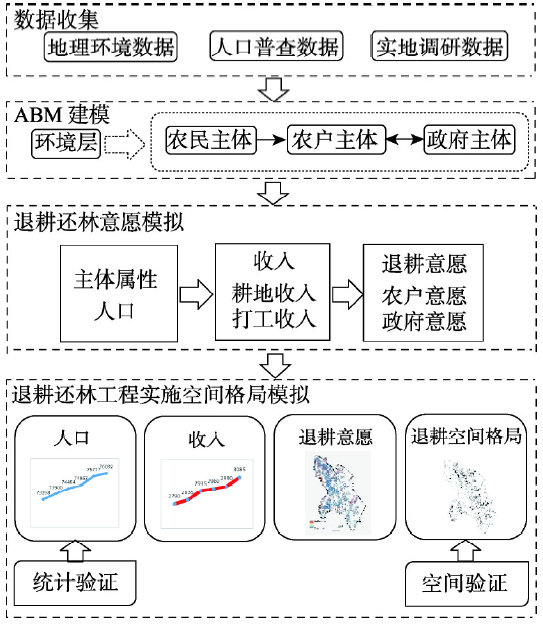 新窗口打开|下载原图ZIP|生成PPT
图1区域退耕还林工程实施空间模拟框架
Fig. 1Framework of regional spatial simulation of "Grain to Green Program" implementation
2.1 决策主体退耕还林意愿
在退耕还林工程实施空间模拟中考虑3类主体:政府、农户和农民,其中农户、政府共同决策地块是否退耕还林。农户主体由农民主体组成,农民主体通过年龄、生育、死亡等属性与退耕还林决策直接相关的农户劳动力变化相联系。农户主体根据退耕还林前后的收入变化,确定其家庭层面退耕还林意愿。政府主体根据国家政策和本区域退耕还林要求确定区域内地块尺度的政府退耕还林意愿。以地块为模拟空间单元,综合考虑农户和政府主体退耕意愿,确定不同地块退耕还林意愿排序,根据区域退耕还林工程规划确定的退耕面积,实现退耕还林工程实施的空间模拟。2.1.1 农民主体 农民是退耕还林工程的实际参与者,与农民主体直接相关的年龄结构、出生、死亡等属性特征将导致农户和区域劳动力变化。在模拟过程中农民主体将劳动力变化传递给农户。模型运行中需首先根据人口普查数据或实地调研数据确定农民数量与年龄结构、生育率、死亡率、打工收入。
2.1.2 农户主体 农户主体是退耕还林工程实施的实际决策主体之一。农户尺度上的决策通过退耕前后农户年收入差异判断,即参与退耕还林工程后农户年收入增加越多,退耕还林意愿越强烈。总体上,农户收入包括打工收入和土地收入,本文首先计算农户参与退耕还林后打工年收入变化和农户土地年收入,最后加上退耕还林年补贴,即可得到参与退耕后农户年收入变化,具体按照如下步骤计算:
(1)农户参与退耕后打工年收入变化。根据中国退耕还林工程实际情况,农户在参与退耕还林工程前,大部分以半农半工为主,并且打工率、打工收入一般会低于参与退耕还林工程后,因此农户参与退耕后打工年收入变化可用下式计算:
式中:
(2)农户土地年收入。农户土地年收入计算与常规土地收入计算相一致,即综合考虑与土地产出相关的自然和社会经济因素,包括:海拔、坡度、土壤肥力、交通条件劳动力等,用下式计算:
式中:
(3)参与退耕后农户年收入变化。在得到
式中:
(4)农户退耕还林意愿。作为具有决策能力的农户,是否参与退耕还林工程,取决于参与该工程后农户年收入变化,如果参与工程后农户年收入提高越多,则该农户参与意愿越强烈。农户退耕还林意愿采用标准化的参与退耕后农户年收入变化来表达:
式中:
2.1.3 政府主体 中国退耕还林工程实施中各级政府起到了重要作用,主要体现为落实退耕规划面积和决定实施范围。从政府主体考虑,工程实施中主要考虑的是退耕地坡度、土壤肥力、生态重要程度和工程实施难易程度。与确定农户退耕还林意愿一致,本文采用标准化方法来表达政府主体决策意愿:
式中:
2.2 地块尺度退耕还林实施模拟
在确定了农户和政府退耕还林意愿之后,最终在地块上综合政府与农户退耕还林意愿,实现退耕还林工程实施的精确模拟。具体模拟过程为:通过上述2.1方法确定农户和政府的退耕还林意愿,基于区域每年退耕面积指标(以政府管理的视角,每年通过退耕还林工程面积指标来约束退耕面积),对区域内符合退耕要求(坡度> 25°)的耕地地块,按照地块退耕还林总意愿由大至小排序,确定实施退耕还林地块,直至完成退耕还林工程面积指标(地块所对应的农户可能是一对多,因此地块上农户退耕意愿取地块上所有农户的平均值)。式中:
2.3 数据获取
本文模型的数据主要包括主体属性数据、耕地收入数据、地理环境数据、退耕数据4类。主体属性数据通过实地调研、人口普查数据等获取,耕地收入数据通过实地调研获取,地理环境数据通过遥感影像、中国科学院资源环境科学数据中心网站(Tab. 1
表1
表1区域退耕还林工程实施空间模拟数据列表
Tab. 1
| 数据类别 | 数据项 | 数据来源 |
|---|---|---|
| 主体属性数据 | 农户家庭规模比例 | 人口普查数据、实地调研 |
| 年龄结构 | ||
| 生育率(分年龄段) | ||
| 死率亡(分年龄段) | ||
| 农业人口总量 | ||
| 打工收入(分年龄段) | ||
| 耕地收入数据 | 同海拔最高肥力耕地最大年收入( | 实地调研 |
| 耕地坡度系数(αSD) | ||
| 耕地肥力等级系数(αSQ) | ||
| 耕地年交通费用(CostTra) | ||
| 单位耕地最低需求劳动力(LaborMin) | ||
| 地理环境数据 | 海拔 | 中国科学院资源环境科学数据中心、遥感影像处理、部门调研等 |
| 坡度等级 | ||
| 土壤肥力等级 | ||
| 土地利用类型 | ||
| 离公路网距离 | ||
| 离城市中心距离 | ||
| 行政区划 | ||
| 退耕数据 | 退耕还林工程面积指标 | 部门调研 |
新窗口打开|下载CSV
2.4 模型运行
2.4.1 模型初始化 在模型运行中需要生成农民、农户主体,并将农户主体与地块空间关联。具体操作中根据(表1)获得的人口普查数据确定区域农业总人口和年龄结构,再依据家庭规模比例生成农户主体,最后综合行政区范围和耕地面积等因素,建立农户与地块间的空间对应关系(图2)。图2
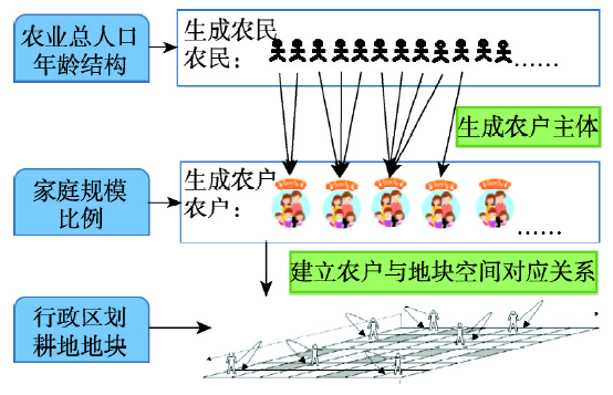 新窗口打开|下载原图ZIP|生成PPT
图2区域退耕还林工程实施空间模拟的农民和农户主体初始化
Fig. 2Initialization of farmers and farmer household agents for the regional spatial simulation of "Grain to Green Program"
2.4.2 模拟过程 模型模拟周期为1年,模型运行顺序(图3):① 更新农民主体:农民年龄每年+1,根据生育率、死亡率、确定农民人口变化;② 更新农户主体:根据农民人口数量和年龄,更新农户家庭成员劳动力状况;③ 计算农户参与退耕还林工程后打工年收入变化:根据该农户所有家庭成员(农民)退耕还林前后打工年收入差异计算得出该农户的打工年收入变化;④ 计算农户土地年收入:依据土壤肥力、海拔、坡度、劳动力、交通条件等因素计算农户土地年收入;⑤ 计算农户退耕还林意愿,根据退耕还林后农户年收入差异确定农户意愿;⑥ 计算政府退耕还林意愿,依据政府优先考虑地块参与退耕还林工程的条件确定;⑦ 计算地块实施退耕还林总意愿:综合考虑农户和政府决策意愿,利用权重系数获得地块尺度退耕还林总意愿;⑧ 地块执行退耕还林工程:基于地块退耕还林总意愿大小排序,按照每年退耕还林面积指标,由大至小依次在地块尺度上执行退耕还林,实现区域退耕还林工程实施空间过程的模拟。
图3
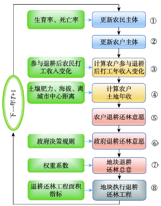 新窗口打开|下载原图ZIP|生成PPT
图3区域退耕还林工程实施空间模拟流程
Fig. 3Process of the regional spatial simulation of "Grain to Green Program" implementation
3 案例研究
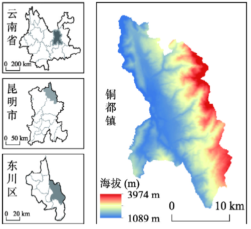
横断山区属于川滇森林及生物多样性国家重点生态功能区[24],是中国退耕还林工程实施的重点地区。本文选择横断山区典型区域铜都镇为研究区(图4),开展区域退耕还林工程实施空间模拟研究。图4
 新窗口打开|下载原图ZIP|生成PPT
图4铜都镇区位
Fig. 4Location of Tongdu Town
3.1 研究区域
铜都镇属金沙江一级支流小江流域,土地面积36668.32 hm2,2017年人口129627人⑤(⑤昆明市东川区统计局. 《昆明市东川区国民经济统计资料(二〇一七年)》, 2018.05.),人口密度为3.54人/hm2。该镇海拔1089~3974 m,垂直带谱明显[25],其中干热河谷稀树草丛带占总面积38.72%。区域生态脆弱,长期的矿山开采冶炼、农田开垦、森林采伐、破坏等活动加剧了生态退化程度[26],导致水土流失严重、泥石流频发,主要的泥石流沟有蒋家沟、深沟、白云沟、大白沟、块河等[26,27,28],仅块河每年就产生土砂8.26×10⁶ t⑥(⑥云南省水利厅. 《云南小江流域综合土砂灾害治理及自然环境修复规划调查》, 2005.12.)。研究区内坡耕地比重较高,仅坡度> 25°耕地占总耕地面积的23.72%。自2000年开始实施退耕还林工程以来,截止到2015年共退耕还林2612.57 hm2,其中2010—2015年共退耕还林1813.33 hm2 ⑦。退耕还林工程在本区域效果明显,实施退耕还林工程区域表面侵蚀降低8.00×10⁵ m3/hm2 ⑥。截止2015年仍有960.43 hm2坡度> 25°的耕地未实施退耕还林工程。在国家政策因地制宜、先易后难的前提下,由于研究区人民生命财产安全受到严重地质灾害威胁,且偏远地区已有自行退耕趋势,故优先在研究区人类活动强烈且易于实施工程(靠近公路)的区域实施退耕还林工程⑦(⑦云南省东川区林业局. 《昆明市东川区“十三五”林业发展规划》, 2015.)。
3.2 退耕还林工程实施模拟
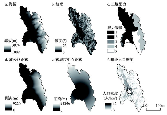
3.2.1 模拟数据处理 模拟数据包括实地调研数据、人口普查数据、地理空间数据等,其中人口普查数据精度到行政村,地理空间数据精度30 m×30 m,数据年份为2010年,并将空间化数据处理成100 m×100 m的网格(图5)[29]。课题组2015年5—7月对研究区进行了实地调研,访谈了东川区人民政府、铜都镇人民政府,并走访了块河、洗尾戛、腊利、梨树坪、姑海、达贝、紫牛、小牛厂、磨盘山、岩脚、奔多、赖石窝、新村、戛德、野牛、箐口16个村民村委会,面对面问卷调查637户,有效问卷512份,有效率80.38%。图5
 新窗口打开|下载原图ZIP|生成PPT
图5铜都镇退耕还林工程实施模拟的空间化数据
Fig. 5Spatialized data for the spatial simulation of "Grain to Green Program" implementation in Tongdu Town
模型时间分辨率为1 a,起始年为2010年。退耕还林补贴7500元/(hm2·a)。在铜都镇退耕还林工程实际执行中坡度> 25°且离公路越近的耕地,优先退耕还林,因此公式(5)中,
3.2.2 农民属性模拟
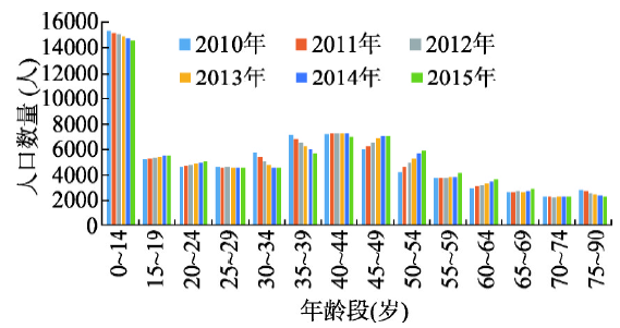
(1)农村劳动力数量及结构模拟。2010起始农业人口为73298人⑧(⑧云南省东川区第六次全国人口普查办公室. 《昆明是东川区第六次全国人口普查资料汇编》, 2014年5月.),模拟得到铜都镇2011—2015年农业总人口分别为73462人、73607人、73731人、73890人和74113人,人口总量呈现缓慢增长趋势(图6),人口结构变化呈现老龄化趋势表现为45岁以下人口减少了2733人,45岁以上人口增加了3548人。
图6
 新窗口打开|下载原图ZIP|生成PPT
图62010—2015年铜都镇农业人口
Fig. 6Farming population in Tongdu Town from 2010 to 2015
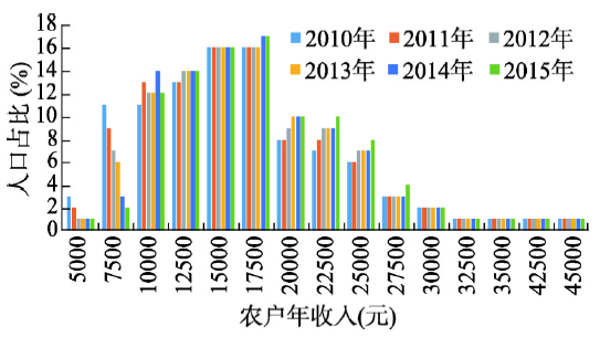
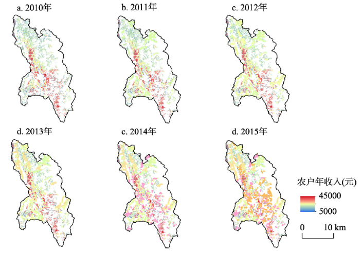
(2)农户年收入模拟。采用前述公式(1)~(3),模拟得到铜都镇2011—2015年铜都镇农户平均年收入为16775元、17275元、17400元、17550元、18025元,农户年收入呈现增加趋势,农户年收入7500元以下的农户比例减少,17500~27500元区间段农户比例增加(图7)。在空间分布上(图8)可以看出靠近城市中心、公路且坡度较小的区域农户年收入较高,原因在于靠近城市中心和公路的区域坡度和交通成本较低。对比2011—2015年农户收入,总体农户年收入较低的区域收入提高明显,最为显著的是铜都镇北部低收入区域,此区域也是退耕还林工程实施集中区域。
图7
 新窗口打开|下载原图ZIP|生成PPT
图72010—2015年铜都镇不同收入区间人口特征
Fig. 7Demographic features of different income ranges in Tongdu Town from 2010 to 2015
图8
 新窗口打开|下载原图ZIP|生成PPT
图82010—2015年铜都镇农户年收入的空间分布
Fig. 8Spatial distribution of annual income of farmer households in Tongdu Town from 2010 to 2015
3.2.3 政府和农户退耕意愿 农户退耕意愿在离城市远,坡度高的区域较高,政府退耕意愿较高的区域分布在公路沿线且坡度较高的区域,总退耕意愿则在离城市较远,靠近公路且坡度较高的区域呈现较高值(图9)。对比2010年和2015年退耕意愿,发现农户、政府和总意愿变化较小。
图9
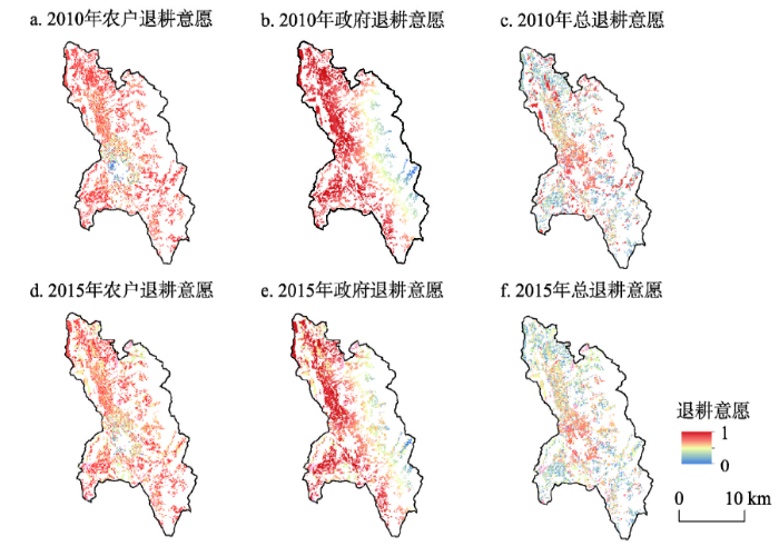 新窗口打开|下载原图ZIP|生成PPT
图92010铜都镇地块退耕还林意愿模拟
Fig. 9Simulation of willingness to "Grain to Green Program" in Tongdu Town in 2010
3.2.4 退耕还林工程实施空间布局模拟 本文模拟了2011—2015年退耕还林工程实施空间格局,总共退耕1813.33 hm2。主要分布在沿公路两旁,坡度> 25°的区域。从空间分布可以看出最先退耕的区域主要分布于铜都镇北部和南部公路交汇处(图10)。
图10
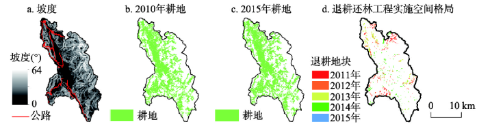 新窗口打开|下载原图ZIP|生成PPT
图102010—2015年铜都镇土地利用变化
Fig. 10Land use change in Tongdu Town from 2010 to 2015
3.3 退耕还林工程实施模拟结果
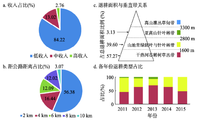
3.3.1 主体属性模拟 参与退耕还林工程的农户年收入较低的(< 15000元)占84.22%,中等(15000~20000元)占13.02%,高收入(≥ 20000元)占2.76%。可见退耕还林工程实施与农户年人均收入密切相关(图11a),收入较低的农户参与退耕还林较多,这与政府退耕还林工程偏向贫困地区的初衷一致。从本文3.3.2农户年收入变化模拟结果可以看出,年收入低于12500元的农户比例降幅最大,年收入20000~27500元的农户比例增加最高,参与退耕还林工程的农户年收入增加幅度主要集中在7000~15000元,这与当地调研结果相符。在计算地块总意愿时,当公式(7)中政府退耕意愿图11
 新窗口打开|下载原图ZIP|生成PPT
图11退耕还林与农户年收入、耕地分布的关系
Fig. 11Relationship of "Grain to Green Program" with the distribution of cropland and annual income of farmer households
3.3.2 退耕还林工程实施的空间过程模拟 在退耕还林工程实施与距离公路远近关系方面(图11b),离公路距离0~2 km、2~4 km、4~6 km、6~8 km、8~10 km处,退耕还林工程实施的面积分别是56.37%、16.44%、12.09%、12.02%、3.07%,离公路较近的区域退耕还林工程实施比例高。在退耕还林工程实施与垂直带关系方面(图11c),退耕还林工程实施区域主要分布在干热河谷稀树草丛带和山地常绿阔叶与针叶林带,其中干热河谷稀树草丛带占57.27%,这主要是因为公路多分布于该垂直带。在退耕还林工程实施与坡度关系方面,实施退耕还林区域中坡度25°~30°耕地占81.47%,坡度30°~35°耕地占15.26%,坡度> 35°耕地占3.27%,可见坡度25°~30°耕地占比最高,原因在于这部分耕地具有相对较好的交通条件,易于实施退耕还林工程,这与中央政府要求的先易后难的退耕还林工程实施要求一致。在退耕还林工程实施与土壤肥力的相关分析中P = 0.745,可以看出土壤肥力与退耕还林工程的实施相关性小,因为土壤肥力对耕地收入影响较小,农户通过化肥改良土地等方法降低因土壤肥力差异导致的耕地收入差异。可见退耕还林工程实施的空间过程模拟合理。
3.3.3 模型验证 本文将模拟的退耕还林工程实施区域与2010—2015年铜都镇耕地转化为林地的区域对比,显示91.12%的像元匹配,本文采用2010—2015《东川年鉴》验证了铜都镇农业人口数量,误差4.22%,说明模拟结果具有较高的精度和可信度(图12)。
图12
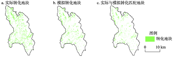 新窗口打开|下载原图ZIP|生成PPT
图12模型验证结果
Fig. 12Validation of models
4 结论与讨论
本文提出了一种结合社会和空间途径,基于ABM模型的退耕还林工程实施的空间模拟方法,并以云南省东川区铜都镇为例,综合地理环境、人口普查、实地调研等数据,模拟了2010—2015年铜都镇农户收入、农户、政府退耕还林意愿,以及退耕还林工程的空间实施过程,模拟空间精度91.12%,模型精度较高。本文充分考虑农户意愿,在地块尺度综合政府和农户意愿实现退耕还林实施空间过程的精确模拟。结果显示退耕还林工程的实施与农户年收入、耕地坡度、离公路距离等因素密切相关。总体上农户收入低、坡度为25°~30°、离公路近的区域退耕还林工程实施面积较大。在社会效益方面,退耕还林工程的实施有效增加了农户收入(尤其是低收入农户),农户增加的收入来源于参与退耕还林工程后获得的补贴以及更高的打工收入,2010—2015年铜都镇农户年平均收入由16550元/户,提高到18025元/户。模型实现了农户年收入、农户退耕还林意愿等社会途径的空间化,为中国精准扶贫、生态扶贫、退耕还林等工程的空间落实提供方法借鉴。本模型参数的设置具有较强的灵活性,例如区域生育率、退耕还林工程实施的坡度范围、退耕还林工程补贴金额等参数,这些参数的变化可能改变退耕还林工程实施区域和范围。模拟显示人口出现总量上升但年龄结构老化的情况,因本文模拟周期较短,人口变化对土地利用尚未产生重要影响,在后续长期模拟中,可以深入探究人口变化对退耕还林工程决策的影响。
参考文献 原文顺序
文献年度倒序
文中引用次数倒序
被引期刊影响因子
DOI:10.1126/science.1111772URLPMID:16040698 [本文引用: 1]

Land use has generally been considered a local environmental issue, but it is becoming a force of global importance. Worldwide changes to forests, farmlands, waterways, and air are being driven by the need to provide food, fiber, water, and shelter to more than six billion people. Global croplands, pastures, plantations, and urban areas have expanded in recent decades, accompanied by large increases in energy, water, and fertilizer consumption, along with considerable losses of biodiversity. Such changes in land use have enabled humans to appropriate an increasing share of the planet's resources, but they also potentially undermine the capacity of ecosystems to sustain food production, maintain freshwater and forest resources, regulate climate and air quality, and ameliorate infectious diseases. We face the challenge of managing trade-offs between immediate human needs and maintaining the capacity of the biosphere to provide goods and services in the long term.
[本文引用: 1]
[本文引用: 1]
DOI:10.18306/dlkxjz.2018.01.016URL [本文引用: 1]
Land change has long been the research hot-spot of geography, and is also the focus of multiple disciplines including resource and environment economics, ecology, and urban planning. Land change models and simulations are an effective approach for understanding the mechanism of human-environment interactions. The modeling results are also valuable for the government to make resource management and environmental policies. Researchers of different fields have applied various approaches based on their theories to develop land change models. Attention has evolved from modeling land cover types to representation of human decision-making behaviors. The methods have shifted from statistical to cellular automata that can better characterize spatial patterns, and to economic methods and agent-based methods that can better represent the processes and mechanisms of land change. Future land change models should focus coupling multiple methods cross scales. Land change processes should be better represented. The complexity of the human-environment system can be better explained by a combination of land change models and other earth system models. The application of models to support policymaking also needs more attention.
[本文引用: 1]
[本文引用: 1]
[本文引用: 1]
URLPMID:12148073 [本文引用: 1]
[本文引用: 1]
[本文引用: 1]
[本文引用: 1]
[本文引用: 1]
[本文引用: 2]
DOI:10.1007/s10980-007-9135-1URL [本文引用: 1]
[本文引用: 1]
DOI:10.1016/j.landusepol.2014.03.006URL [本文引用: 1]
This themed issue of Land Use Policy builds mainly on papers presented at an international conference on 'Land Use Issues and Policy in China under Rapid Rural and Urban Transformation', convened by the Chinese Academy of Sciences in Beijing, China, in October 2012. The conference set out to share and promote new scientific findings from a range of disciplines that advance research on land use policy in China. The contributions to this themed issue provide conceptual-theoretical and empirical takes on the topic, around four main areas of interest to both researchers and policymakers: nation-wide land use issues, the Sloping Land Conversion Program, land engineering and land use, and land use transitions. Various land use issues have been associated with rapid urban-rural transformations in China, giving rise to formulation of new policies directly affecting land use. However, these have contributed to new land use problems due to the nature of the policies and the difficulties in policy implementation constrained by the special 'dual-track' structure of urban-rural development in China. In view of this, this themed edition makes a compelling call for more systematic research into the making and implementation of China's land use policy. It also emphasizes the challenges for further research on land use policy in China. (C) 2014 Elsevier Ltd.
DOI:10.13287/j.1001-9332.201606.004URLPMID:29737675 [本文引用: 1]
Based on the estimation of carbon cost from afforestation in project boundary and carbon leakage out of boundary in the construction period of
PMID:29737675 [本文引用: 1]
[本文引用: 1]
[本文引用: 1]
DOI:10.1016/j.ecolmodel.2011.06.007URLPMID:22389548 [本文引用: 1]
Conservation investments are increasingly being implemented through payments for ecosystem services (PES) for the protection and restoration of ecosystem services around the world. Previous studies suggested that social norms have substantial impacts on environmental behaviors of humans, including enrollment of PES programs. However, it is still not well understood how social norms are affected by the design of PES programs and how the evolution of social norms may affect the efficiency of conservation investments. In this paper, we developed an agent-based simulation model to demonstrate the evolution and impacts of social norms on the enrollment of agricultural land in a PES program. We applied the model to land plots that have been enrolled in China's Grain-to-Green Program (GTGP) to examine reenrollment in an alternative payment program when the current payments ceased. The study was conducted in Wolong Nature Reserve where several thousand plant and animal species, including giant pandas, may benefit from the reenrollment. We found that over 15% more GTGP land can be reenrolled at the same payment if social norms were leveraged by allowing more than ten rounds of interactions among landholders regarding their reenrollment decisions. With only three rounds of interactions, an additional 7.5% GTGP land was reenrolled at the same payment due to the effects of social norms. In addition, the effects of social norms were largest at intermediate payments and were smaller at much higher or much smaller payments. Even in circumstances where frequent interactions among landholders about their enrollment decisions are not feasible, policy arrangements that divide households into multiple waves for sequential enrollment can enroll over 11% more land at a given payment level. The approach presented in this paper can be used to improve the efficiency of existing PES programs and many other conservation investments worldwide.
[本文引用: 1]
[本文引用: 1]
[本文引用: 1]
[本文引用: 1]
[本文引用: 1]
[本文引用: 1]
[本文引用: 1]
[本文引用: 1]
[本文引用: 1]
DOI:10.11821/dlxb201502002URL [本文引用: 1]
Major Function Oriented Zoning (MFOZ) is the blueprint for the future developmnt and protection pattern of China's territory, and has been raised to from major function zones planning to major function zoning strategy and major function zoning institution. From 2004 to 2014, the author organized a series of research projects to compose MFOZ for the country, studied basic theory of regional function and MFOZ technical process, and proposed that space controlling zones of national and provincial scales can be divided into four types: urbanized zones, foodstuff-security zones, ecological safety zones, cultural and natural heritage zones. On this basis, major function zones of county scale should be transferred to optimized, prioritized, restricted, and prohibited zones. In this paper, a regional function identification index system comprising nine quantitative indicators (including water resources, land resources, ecological importance, ecological fragility, environment capacity, disaster risk, economic development level, population concentration and transport superiority) and one qualitative indicator of strategic choice is developed. Based on the single index evaluation, comprehensive evaluation using regional function suitability evaluation index is conducted, aiming at testing several key parameters including lower limit of protection zones and upper limit of development zones at the provincial level. In addition, a planning-oriented zoning method of major function zones is also discussed, which has brought the first MFOZ planning in China. According to the MFOZ caliber, it is forecasted that national spatial development intensity will rise from 3.48% in 2010 to 3.91% in 2020. Furthermore, according to caliber of the provincial integrated MFOZ planning, the area of optimized, prioritized and restricted zones accounts for 1.48%, 13.60% and 84.92%, respectively, and that of urbanized, foodstuff-security and ecological safety zones accounts for 15.08%, 26.11% and 58.81%, respectively. In combination of analyses of development level, resources and environmental carrying status and quality of the people's livelihood, the main characteristics of MFOZ were identified. Through verification, MFOZ draft of national and provincial scales, which is interactively accomplished with "MFOZ Technical Process" put forward by the author, is mostly above 80% identical with what have been forecasted.
[本文引用: 1]
[本文引用: 1]
[本文引用: 1]
[本文引用: 2]
[本文引用: 2]
[本文引用: 1]
[本文引用: 1]
[本文引用: 1]
[本文引用: 1]
[本文引用: 1]
