 , 姜逢清
, 姜逢清On the problems of urbanization in the Yangtze River Deltaunder the background of global change
ZHUCheng, JIANGFengqing收稿日期:2016-05-9
修回日期:2016-11-14
网络出版日期:2017-04-20
版权声明:2017《地理学报》编辑部本文是开放获取期刊文献,在以下情况下可以自由使用:学术研究、学术交流、科研教学等,但不允许用于商业目的.
基金资助:
作者简介:
-->
展开
摘要
关键词:
Abstract
Keywords:
-->0
PDF (1583KB)元数据多维度评价相关文章收藏文章
本文引用格式导出EndNoteRisBibtex收藏本文-->
1 国外城镇化对全球变化的响应研究进展
城镇化发展和全球气候变化的关系非常复杂。在全球气候变化的背景下,城市直接或间接的影响温室气体的汇和源。例如,城市是人类燃烧化石燃料来供热制冷时排放二氧化碳的主要来源地,超过90%的二氧化碳排放来自城市[1]。城镇化既是一种社会现象也是景观的一种物理转变——是人类作用于地球上的一种强大而不可逆转的影响因素。许多与全球变化有关的最重要、最明显的改变往往发生在城镇地区。超过一半的世界人口居住在城镇地区,未来人口增长的90%以上很可能会集中在城镇区和贫困国家,人口的快速增长和人口主要集中于城镇区对人类的长远发展具有重要影响。由于背负着与经济增长、城镇面积扩张等相关的许多问题,城镇也面临着越来越剧烈的危机。上述问题反映了城镇化和全球环境变化之间复杂的相互作用。国外的部分****在城镇化对全球变化的响应方面开展了深入研究。Seto等在国际上诸多知名期刊发表了多篇与本研究密切相关的论文[2-4];Solecki等发表了《当前是城市化科学发展的时代》论文[5];Trusilova等[6]研究发现,在过去20年欧洲很多地方植被用地向城市用地的转变,导致不透水地表面积增加,植被覆盖面积减少,人工热源增加,最终导致气候变化——城市用地每扩张40%,将导致某些地区热效应指数增加至原来的两倍。Kishtawal等[7]研究了城市化发展对印度季风区降水量的影响,发现在季风季节印度城市地区的暴雨出现频率呈日益增加趋势,极端暴雨事件在城市和乡村地区的降水量均呈上升趋势,而在城市区这种上升趋势更加明显。Misra等[8]研究发现,恒河地区潜水面正在以平均每年0.2 m的速度下降,气候变化可能导致温度上升2~6 ℃,使得降水量减少高达16%,降水量的减少也导致地下水供给量减少为原来的50%。
德国****构建快速城镇化进程中城乡社会系统应对全球变化的响应模式,提出适应全球变化的城镇化可持续发展策略,Roberto[9]曾从4个方面研究全球变化与城镇化发展的关系:首先研究的基本框架是以城镇系统导致全球环境变化的过程开始;其次研究全球环境变化是通过哪些具体途径影响到城镇系统;第三,一旦上述途径和交叉点被查明,该框架则揭示了城镇化与城镇系统产生的相互影响及其响应;最后,该框架集中于城镇系统和全球环境变化相互作用的后果或反馈过程。这4个方面从全方位的角度认知和揭示了城镇系统和全球环境变化过程之间动态化的、多元化的和复杂的相互作用关系。这个基本框架从不同层次的基本流程到过程的相互作用和联系可描述如下:① 城镇区域和全球环境变化(社会、文化、经济、政治和生物物理)层面之间的相互作用;② 跨时间和跨空间尺度的方法;③ 跨区域和跨时间的并行计算和比较研究;④ 不同参与者和城镇地区基于复杂动力学网络之间的相互作用。
2 全球变化背景下长三角城镇化发展进程中应重点研究的几个问题
长三角是世界公认的六大城市群之一[10](图1),是中国接驳世界经济体系的首位门户区,是中国现代化建设的龙头和深化改革的前沿阵地。国务院[11]2008年《关于进一步发展长三角的指导意见》中确定:“将长三角扩大到两省一市,即江苏、浙江两省和上海市”。这里人口密集,财力雄厚,城镇广布,文教昌明,是中国唯一一个从古代到近现代持续不断的保持高水平发展的发达地区,也是中国目前城镇化发展速度最快、经济总量规模最大、最具有发展潜力的地区。统计数据显示[12],2012年中国国内生产总值(GDP)为51.947万亿元人民币,而长三角江浙沪三省市面积21万km2,人口1.3亿,GDP为10.8845万亿元,长三角以占全国2%的陆地面积、10%的人口,创造了21%的GDP,平均每平方公里GDP产值0.52亿元。2015年全国人均GDP为7500美元,江苏省人均GDP已达13200美元。在这片中国最富庶的土地上,目前世界500强企业已有400多家在这一地区落户,集中了近半数的全国经济百强县,也是海港建设最多最快的地区。长三角地区既是中国经济发达区,又是自然与人类活动相互作用的强烈区,面临着气候变化和人类活动相互作用引起的各类环境生态问题。根据多年研究,笔者认为在全球变化背景下长三角城镇化发展进程中今后应注重研究以下几方面问题:① 海面上升;② 极端气候事件;③ 道路拥挤交通事故增多;④ 人口剧增;⑤ 造陆作用减弱和海水倒灌;⑥ 地面沉降;⑥ 环境污染;⑧ 雾霾和PM2.5加剧;⑨ 核电站隐患。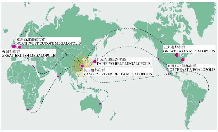 显示原图|下载原图ZIP|生成PPT
图1世界公认的六大城市群[
-->Fig. 1The world's recognized six urban agglomerations[
-->
(1)海面上升:从IPCC(2013)公布的全球海面上升速率[13]看,与中国其他地区相比,长三角地区海面上升最为显著(1978-2007年为78~115 mm)。
(2)极端气候事件:长三角现代极端灾害事件显著。2013年10月,受台风“菲特”的影响,浙江余姚市70%城区被淹,全市79个降雨量监测点中有39个超过500 mm,24小时降雨量和姚江水位当时均创新中国成立以来最高纪录。2016年6月23日江苏阜宁龙卷风导致98人遇难,引起国内外关注。
(3)道路拥挤交通事故增多:城市化是伴随工业化进程发展的,同时也产生一系列复杂问题,如交通堵塞和交通事故增多。仅2015年1-7月,江苏省公安交警部门吊销肇事者驾驶证并禁驾10909人,其中73人被禁驾10年,387人被终生禁驾。江苏省公安交警部门在全国各省区率先公布禁驾名单。
(4)人口剧增:上海市政府2016年6月份已正式公布其城市户口将控制在2500万人,目前拥有上海市户口的人员已达2420万人,最多还能容纳80万人。
(5)造陆作用减弱和海水倒灌:同济大学李从先等[14]2004年就讨论过长江输沙量减少及其危害性问题,他提出在三峡大坝蓄水前,长江多年平均输沙量约5亿t,蓄水后的2006年宜昌站的输沙量只有0.64亿t,大坝下游的含沙量只有以前的两成。来沙量减少,一是使下游长江三角洲原来的沉积造陆作用减弱,水土流失和海水倒灌显现;二是造成沿江岸坡的冲刷,堤防崩岸频繁发生,仅荆江河段近几年发生的崩岸就有48处。2014年7月17日《东方早报》报道:“对上海有利的没有了,例如,泥沙对于上海是一个很重要的资源,过去平均每年海岸带陆地要向海岸伸出40 m,现在对上海有害的在增加,长江污染、海水倒灌、海岸冲刷等在加剧,将来最大的受害者就是上海”。
(6)地面沉降:从地面沉降看[13],长三角区内1/3范围累积沉降已超200 mm。面积近10000 km2。20世纪70年代上海地区地面沉降率曾高达37.6 mm/年,80年代进行地下水人工回灌后沉降有所减缓,但近年来因受城市化高层建筑猛增的影响,沉降又有加剧趋势。
(7)环境污染:长三角快速城镇化发展中因大量侵占农业、生态用地,致使环境污染不断增加,2011年太湖流域劣V类水体已占40.6%。江苏每年因污染造成的损失高达429亿元[15]。
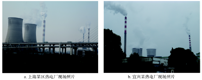
(8)雾霾和PM2.5加剧:长三角境内热电厂对PM2.5的影响值得重视(图2),而2013年7月17日美国国家环保通讯公布全球每年约210万人死于空气污染。
 显示原图|下载原图ZIP|生成PPT
图2长三角部分热电厂烟囱与冷却塔现场照片
-->Fig. 2Chimney & cooling tower of some thermal power plants among the Yangtze River Delta
-->
(9)核电站隐患:在当前朝鲜半岛和南中国海以及钓鱼岛等复杂国际局势下,江苏连云港田湾核电站、浙江境内嘉兴秦山核电站和江西省鄱阳湖畔彭泽核电站是否会对长江下游和华东地区构成核污染和核辐射隐患?值得高度重视。
此外,苯被国际癌症研究中心确认为高毒致癌物质,主要影响造血系统、神经系统,对皮肤也有刺激作用,故对其含量应严加控制。甲苯和二甲苯对人体的危害主要是影响中枢神经系统、对呼吸道和皮肤产生刺激作用,二甲苯也是一种麻醉剂,长期接触可使神经系统功能紊乱。2016年10月9日在南京市栖霞区的南京炼油厂发生爆燃引起全国关注,但目前该厂却还在生产二甲苯,其管道很多露天分布,如果发生二甲苯爆炸事故将危及人类生命安全,由于其附近的栖霞区仙林大学城是江苏省规模最大的大学城,集聚了南京大学、南京师范大学等12所高校,在校师生约17.5万人、两院院士多达30余名,因此,对以上现象值得高度关注。
2.1 气候变化与城镇化发展的演变关系
要了解全球变化对长三角城镇化的影响,首先需要摸清不同时间尺度周期性气候变化和灾变事件对该区人居环境的影响,其次是要厘清改革开放近40年来人类活动和快速城镇化进程对气候变化和全球变化的响应。长三角的城镇化发展从无到有经历了从新石器时代以来的遗址→聚落→乡村→城镇→城市的发展过程。长三角城镇形成过程中曾受到气候引起的海面变化和极端灾害事件的影响。国内外****在气候变化对人居环境影响方面做过许多研究,就长三角而言,前期研究发现,在新石器时代,因当时人口少,本区城镇格局尚未形成,仅以聚落形式分布,人类对自然界影响较小[16-17],当时主要是自然界气候—海面变化和气候—水文过程对陆表格局变化和人类生存产生的影响。有关新石器时代气候突变对人类生存影响的研究,国际上认为有3次显著变冷的事件对人类文明演进影响较大,即:8.2 ka BP前后的降温事件,亦被称为全球寒冷(Global Chill)事件[18],5 ka BP前后的榆树衰败事件(Elm Decline)[19]以及4 ka BP前后的降温事件,也称之为“全新世事件3”(Holocene Event 3)的降温事件[20]。Weiss等[21]认为8.2 ka BP前后的降温事件对当时技术尚原始的农业社会来说是毁灭性打击。杭州湾以北约10万km2的江苏境内迄今极少发现7 ka BP以前新石器时代遗址的原因,除与可能的高海面经历有关外[22],是否与8.2 ka BP前后的寒冷事件有关值得继续研究。西北欧地区全新世中期5 ka BP前后的“榆树衰败”事件是一次显著的环境灾变事件,在湖泊、沼泽沉积物花粉谱上,虽然它主要表现为榆树花粉的减少以及小麦、大麦等谷物花粉的出现,但其内涵却是与气候恶化、土壤退化、植物病虫害、新石器时代土地利用、砍伐或烧毁森林等人地关系问题密切相关[18]。宁绍平原的河姆渡文化在7 ka BP前后诞生,却在5 ka BP前后消失[22]。朱诚等[23]根据对苏州澄湖湖底62处古水井和102处灰坑顶底部GPS-CORS系统的测量和出土文物的测年与鉴定也发现,崧泽文化、良渚文化、夏商周和战国时期, 水井井口和灰坑顶部多在1985黄海高程0~-2 m之间,井底和灰坑底部多在-3 m左右;六朝和宋代水井的井口和灰坑顶部曾低于-1 m,水井井底和灰坑底部曾低于-4 m,表明澄湖是宋代以后才逐渐演变为湖泊的。太湖地区的崧泽文化在5.8 ka BP前后出现,却在5 ka BP前后转为良渚文化。上述现象是否与5 ka BP前后的气候突变事件有关亦值得深入探讨。发生在4 ka BP前后的降温事件被认为是新仙女木事件以来最为寒冷的一次全球性降温过程[24];标志着许多地区气候最适宜期的结束和晚全新世的开始[25]。受其影响,西亚地区进入寒冷干旱期,非洲撒哈拉沙漠中的淡水湖全部干涸[26]。在中国,这次气候事件总体上导致了南涝北旱的环境格局[27]。这一时期的长三角地区,中国新石器玉器文化史上具有辉煌一页的良渚文化在4 ka BP前后突然消失的成因至今仍是中华文明探源研究的核心问题之一。4 ka BP前后的冷事件和古洪水事件发生在长三角人类文明发展史上的低潮时期,表现在该时期人类遗址聚落数量相对较少,在考古地层学上呈现为文化断层(或文化间歇层)现象[28]。Jian等[29]根据东海大陆架沉积物中海相微体古生物组合特征的鉴定结果,发现4 ka BP前后黑潮暖流向东偏离了约100 km,这是否对长三角良渚文化的消失带来了灾变性的气候-海面变化事件影响还有待在今后研究中得到证实。过去的研究表明[22-23],长三角地区全新世存在过显著的气候—海面变化,Wang等[30]对贵州董哥洞石笋高分辨率的研究表明,中国全新世存在显著的千年周期冷暖波动事件,这种千年周期的冷暖波动是否会引起未来气候—海面变化并进一步影响长三角城镇化过程?值得在以后的研究中进一步深入探讨。从中长尺度海面变化研究看,英国****Smith等[31]、Turney等[32]认为8.7-8.1 ka BP北美劳伦泰冰架的崩溃和淡水的注入,使温盐环流减弱,由此造成海面上升1.4 m,使得北大西洋沿岸新石器时代部落灭绝或迁徙。Tjallingii等[33]通过对越南东南部大陆架沉积物的研究发现,9.5-8.5 ka BP期间,越南和柬埔寨海岸带发生过广泛而快速的海侵和海面上升,上升速率平均约为每年10 mm。上述观点与朱诚等[22]过去的研究结果虽具有某些一致性,但对高海面出现的确切时代(究竟是9.5-8.5 ka BP、8.7-8.1 ka BP还是7 ka BP前后)说法不一,也需要在今后进一步研究证实。作者过去多年从事对长三角环境演变和环境考古的研究,曾通过新石器时代以来人类遗址时空分布变化和地层记录研究,揭示该区全新世高海面大致出现在7 ka BP前的全新世早期,但对高海面确切时代及其对人类遗址聚落从无到有分布的影响以及海面变化对当前和未来快速城镇化发展的影响尚未探究。根据近年的研究,气候变化对中国现代总体的影响是以南涝北旱为主。有必要对该区过去—现在—未来的气候变化问题做综合集成研究,有必要从气候—海面变化和气候引起的极端事件(干旱、洪水、风暴潮、极端高温和冷事件)等角度厘清气候变化对未来城镇化发展的影响。
对于长三角两千年来的情况,朱诚等[34]曾根据对陈高庸等[35]《中国历代天灾人祸表》的记实性史料统计,对照两千年来中国东部气候变化、海面升降与长江口河道变迁的关系,通过对水灾生成频率和强度的分析,提出两晋、南北朝、南宋、元、明和清时期本区经历过多个水灾频发期,并用非线性方法分析后认为,在本区水灾生成事件中旱涝灾害的准60年、准35年和准11年的长周期变化与地球自转速度、地极移动和太阳黑子活动的3个周期变化基本一致[34]。但在水旱灾害对长三角城镇化发展的影响过程方面未做结合研究,在地面沉降[36-37]对本区城镇化发展的影响方面亦较少涉及,值得深入探讨。
对长三角近百年来的气候变化研究,聂安琪等[38]曾利用国家基本、基准站1951-2009年的气候数据分析了京津冀、长三角和珠三角3个城市群的城市气候特征,表明长三角地区的城市化气候效应最强。Shi等[39]曾利用树轮记录重建了长江下游160年以来冬季气温的变化过程。但在极端气候事件对长三角城镇化影响方面的研究不够,值得继续深入探究。
2.2 全球变暖与极端气候对长三角城镇化发展的制约
国务院发布的国家中长期科学和技术发展规划纲要中,将“人类活动对地球系统的影响机制”、“全球变化与区域响应”和“复杂系统、灾变形成及其预测控制”列为面向国家重大战略需求的基础研究内容之一。政府间气候变化专门委员会(IPCC)[40]2007年发布的《第四次气候变化评估报告》指出,近50年以来,全球海面逐渐上升,特别是从1993年来平均速率为每年3.1 mm,冰川和极地冰盖加速融化,海面与全球变暖同步上升。IPCC报告指出,如果全球年平均温度升高3 ℃以上,全球30%海岸带湿地将消失。报告认为,由于气候变暖和海面上升,到21世纪80年代,亚洲人口稠密的大河三角洲受海洋和洪涝灾害影响的人口将比目前多数百万。据IPCC[41]公布的《第五次气候变化评估报告》,从近10年全球能量收支的计算表明,导致全球变暖的温室效应,不但没减弱,而且继续在增加。1993-2010年间海面上升速率为3.2 mm/年,21世纪全球海面将持续上升(图3)。根据中国社会科学院和中国气象局[1]发表的《气候变化绿皮书:应对气候变化报告(2013)》、王伟光等[42]和杜碧兰等[43]的研究可知,气候变化对中国主要城市群影响巨大,1978-2007年上海沿海海面上升115 mm、浙江沿海海面上升98 mm、江苏沿海海面上升78 mm;与中国其他地区相比,长三角地区海面上升速度最为显著,气候—海面变化对长三角城镇化发展的影响正在加大。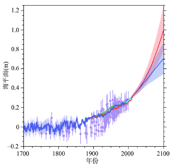 显示原图|下载原图ZIP|生成PPT
图31993-2010年间海面上升速率[
-->Fig. 3Sea level rise rate from 1993 to 2010[
-->
作为中国经济最发达地区之一,长三角位于中国地势第三级阶梯的海岸带,东部为广阔的大陆架,面临太平洋,海陆交互作用显著,受海面变化、台风、风暴潮、地震和海啸等灾变事件的影响和风险正在增大。例如,2013年10月8日,受台风“菲特”带来的强降雨影响,浙江11个市75个县914个乡707.3万人受灾,因灾死亡6人,因洪涝灾害造成的直接经济损失达124.05亿元。浙江省防汛抗旱指挥部报道:2013年10月8日余姚市遭遇新中国成立以来最严重水灾,70%以上城区受淹,24小时降雨量和余姚水位均创1949年以来最高纪录,2013年10月8日晚8时余姚全市79个监测点中有39个降水量超过500 mm,其中最大张公岭站809 mm,受灾人口832870人,房屋受损严重的25650间,转移人口61665人。山区道路交通全部中断。另据《2010中国统计年鉴》[44]可知,2010年江苏洪涝灾害受灾527.8×10⁴ hm2,绝收10.0×10⁴ hm2,旱灾受灾70.4×10⁴ hm2,绝收3.6×10⁴ hm2;浙江洪涝灾害受灾245.2×10⁴ hm2,绝收12.6×10⁴ hm2。2010年长三角受自然灾害的人口及直接经济损失为:江苏受灾人口743.7万人,死亡11人,直接经济损失54.5亿元;浙江受灾人口611.6万人,死亡25人,直接经济损失75.4亿元。因此,在全球变化和快速城镇化背景下,极端气候事件及其灾害风险不断加剧[45],这是长三角城镇化与可持续发展急需解决的重要问题之一。
2.3 气候变化和人类活动相互作用制约长三角的发展
自长江上游三峡工程建坝后来沙量减少[46],长三角沉积造陆作用减弱,加上地下水开采强度不断增长导致地面沉降加剧。全球气候变暖更加剧了海岸侵蚀和海面上升对沿海城市海水全面入侵的影响。由上可知,全球变化引起海面变化和极端气候事件以及因人类活动相互作用有关的生态退化已经日益成为制约长三角可持续发展的重要瓶颈。从气候变化和人类活动相互作用角度分析,长三角快速城镇化发展已带来一系列生态环境问题,城镇空间与产业空间蔓延,大量侵占农业、生态用地,致使土地后备资源短缺,区域生态安全格局面临威胁。作为中国人类活动高度密集区和快速城镇化地区,长三角的环境污染和生态破坏问题日益严重,水质性缺水问题日益突出、区域性大气污染严重、土壤污染形势严峻、生态脆弱性不断增加。在全球变化背景下,长三角地区的城镇格局如何应对气候变化和环境污染的影响?对该问题的回答是中国城镇化发展必须考虑的难题,而该问题的解决将直接决定中国城镇化可持续发展事业的成败。
长三角以太湖为中心的碟形洼地地势低洼,自改革开放以来,本区由于城市化进程、乡镇企业和个体经济发展加快,城市建设和工农业生产中过量抽取地下水和三废排放问题,加剧了地面沉降、水体污染、洪涝灾害和土地利用的矛盾。尤其改革开放以来集体与私营工业企业的快速发展对城镇化格局和农业生态产生重大影响[47]。过去对本区近百年来城镇化过程与气象水文连续观测记录的气候变化之间的关系研究还不够。据中华人民共和国环境保护部《中国环境状况公报》[48]显示:2010年长三角地区国家重点监测的湖泊—太湖、洪泽湖等,水体污染严重,太湖流域劣V类水体已占40.6%。仅江苏每年因污染造成的损失高达429亿元[49]。前人研究表明,长三角典型县级市农田土壤对人体健康影响较突出的Pb、Hg、Cr、Cd、As等重金属元素总体上呈显著增加趋势,综合污染指数已达0.93,属警戒等级[50-51]。
近40年来,工业、农业、城镇化过程和人口压力对陆表格局和生态系统的影响倍增。孙贵艳等[15]、王磊等[52]在研究中已发现,改革开放过程中大量农村人口向长三角城镇集中,人口流动不仅改变了长三角城镇人口空间格局分布的历史,也对长三角人居生态环境产生了重要影响。乡村聚落向城镇化发展,城镇体系的层级、空间结构以及物质流特征改变了乡村与城镇体系的地貌、交通和生态植被、水体等边际条件。长三角苏南模式的集体经济和温州模式的个体经济发展,一方面极大的促进了本区社会经济发展,同时快速城镇化和地面沉降对陆表格局和生态系统也产生了深刻影响。工业和农业三废的排放,对水、土、气的污染也全面加剧,周生路等[53]和袁增伟等[54]过去的研究证实了这一点。从城镇格局看,长三角城镇体系日渐完善,超大城市、特大城市数量较为稳定,中等城市数量显著增加,小城市得到较快发展,大量小城市提升为中等城市,城镇体系等级结构由原先显著的两级分化的格局逐渐趋于合理,并朝着多极化的方向发展,城镇化进入较为高级的发展阶段。从城镇化发展阶段看,20世纪80年代,长三角城镇发展集中于苏南地区,中小城市发展迅速,苏南成为长三角城镇体系演化的动力中心,浙北发展缓慢;90年代浙北中小城市发展开始起步,长三角城镇体系演化的动力重心向南部转移;2000年以来,随着核心城市吸引力不断提升,迎来大城市、特大城市建设高峰。当前,以都市圈一体化、高密度组团式的城市群建设已成为城镇化发展的重点。随着高铁时代的到来,未来长三角区域融合的趋势将更加明显,城镇网络化发展的空间格局将进一步完善[55-56]。从城镇化快速发展带来的生态问题看,长三角地区特别是在上海和苏南等地,城镇与工业用地密集布局,城镇空间与产业空间蔓延,大量侵占农业、生态用地,致使土地后备资源短缺,区域生态安全格局面临威胁[57-61]。此外,由于人口大量集聚不断加剧资源、环境和生态问题:水环境污染严重,区域内水质全面下降,可供饮用的清洁水源越来越少,部分城市水质性缺水严重;工业和生活废弃物排放强度大,带来大气、土壤等方面的环境污染不仅造成严重的经济损失,而且危及市民的身体健康;地下水开采强度不断增长,导致地面沉降塌陷,造成土地渍害、沿海城市海水全面入侵使水质进一步恶化,加上全球变暖引起海面上升;环境污染和生态退化已经成为制约长三角区域发展的重要瓶颈。
2.4 人文与经济地理学视角下长三角可持续城镇化研究
从史料考证研究看,长三角自唐代中叶以来逐渐成为中国经济、文化最发达之所在。此地人口密集,财力雄厚,城镇广布,文教昌明,其产业的商品化程度和社会稳定程度一直高居全国之冠。而且,此后它是中国唯一一个从古代到近现代持续不断地保持高水平发展的发达地区。该区拥有数千年文明史,而且拥有世界一流的历史文献及考证资料[16, 35, 62-69]。由于该区的独特魅力及其深厚的文化底蕴,对该区历史地理的研究,近年来更是吸引了包括日本、美国在内的多国****的共同参与。将自然科学方法与历史地理的文献资料考证相结合将是了解长三角历史时期环境演变和人类活动对陆表格局关键要素影响的重要途径。就100年来本区陆表格局及陆表关键要素变化而言,近百年来随着工业化兴起,农业、人口增多,对陆表格局和生态系统影响逐渐加大,而且也是长三角开始有气象、水文连续观测记录气候变化的时代。尤其上海开埠后,在租界扩展的推动下,长三角由传统的水道纵横、农田纷杂的乡村景观,跃变为近代化城市群的集中区。在近百年的陆表格局变化中,本区最显著的地理特征就是城市和城镇化的空间变化。陆表格局最直观的变化是城市物理空间向周边乡村覆盖和渗透,一条条宽阔的马路逐渐替代了传统的乡村小道,并挤占河浜和滩地,滨海湿地被人为改造成了以水田为主的人工湿地。城市化导致了长三角陆表格局在地貌、水系、湖泊系统、气候、土地覆盖和土地利用等方面全方位的变化。历史时期长三角稳定的农业生态系统受水旱灾害、人口压力影响增大。农田生态景观中圩田、农耕地和村落的历史布局发生显著变化。
3 对今后开展研究的设想
根据上述长三角的现状,作者今后拟侧重对长三角主要代表性城市地区(重点对上海以及南京、杭州、苏州、无锡、常州、温州、宁波、绍兴、南通、扬州、徐州、盐城、连云港、嘉兴)开展历史数据、遥感GIS数据、观测台站数据、水土气和孢粉等采样数据的研究。对历史时期的研究结合史料的收集和考证,对工业革命(18世纪60年代)以来的环境演变将对本区气象站、水文站、验潮站连续30年来观测的数据、1995年以来陆续建成的地面沉降观测点数据进行分析,并对连云港田湾核电站和嘉兴秦山核电站进行供电和冷却安全性调查。作者今后拟研究该区的指标数据包括城镇规划与发展变化、GDP、人口分布、服务设施、碳排放、PM2.5、土壤重金属、气温降水、水文水质、海面变化、地面沉降、孢粉记录等,通过对这些资料和数据的分析,获取长三角城镇化和土地利用变化过程信息,利用GIS技术获取影响土地利用变化的地理要素,运用元胞自动机模型预测长三角的空间格局与演变过程,在研究方法上主要采用作者课题组成员熟悉的研究方案,如对历史数据、遥感GIS数据、水土气和孢粉等采样数据及原始数据、指标数据的过程恢复和建模以及预测与对策研究。此外,集地球空间信息存储、处理、传输和分析于一体的面向大数据时代的“数字地球”、“数字城市”等理念,数据模型、夜间灯光数据、地理计算分析、景观生态学等分析手段的不断丰富[70-71],研究技术手段的长足进步,也将使我们对全球变化背景下长三角地区城镇化发展状态、格局、过程及趋势等问题开展系统的综合性研究成为可能。
4 研究长三角城镇化发展对全球变化响应的意义
著名地理学家任美锷院士曾呼吁[72],应以长三角作为研究地理科学系统理论的试验区,其理由便是该区过去单项要素研究程度较高,但多学科交叉研究不够。中国拥有数千年的文明史,长三角拥有这一地区丰富的考古、沉积地层、气象站、水文站、验潮站、历史考证资料记录和齐全的遥感数据以及丰富的城镇化发展资料等。以此进行个案研究,有利于厘清长三角环境演变与聚落和城镇形成发展的历史过程,有利于探讨城镇化发展在全球变化背景下的可持续发展对策,其学术和社会实践意义都十分重大。全球变化已经成为不可逆转的事实,文中所述众多研究成果也表明减缓性方案对气候变化的贡献十分有限。在这种情况下,开展自然地理学和人文地理学以及地质学等交叉学科综合集成研究是在全球变化背景下探讨中国城镇化可持续发展的重要对策,尤其是针对全球变化可能给人类带来的重大不利影响,从提高人类自身抗影响力和主动适应环境变化两个方面提出人类适应气候变化的模式将有十分重要的研究意义。一方面,结合快速城镇化进程的预期和经济社会发展的需求,从发展目标、指导思想、总体方案、行动策略等方面制定长三角城镇化可持续发展方案;另一方面,基于气候变暖可能对长三角地区城镇化发展的影响,通过对城镇化发展空间的优化调整,将最大限度降低气候变化尤其是全球增暖给长三角城镇化发展带来的不利影响。
The authors have declared that no competing interests exist.
参考文献 原文顺序
文献年度倒序
文中引用次数倒序
被引期刊影响因子
| [1] | |
| [2] | . This paper uses a content analysis of the published literature to take stock of current understanding of key social and policy drivers of migration to cities in 11 Asian and African mega-deltas and identifies commonalities and differences among them. The analysis shows that migration to urban centers in mega-deltas is an outcome of many forces: economic policies and incentives, local and destination institutions, government policies to develop small towns, and the geographic concentration of investments. Massive influx of capital to many deltas has transformed the local economic base from a primarily agricultural one to a manufacturing and processing economy. This has created uneven spatial economic development which is the underlying driver of migration to cities in the mega-deltas regardless of geographic context or size. Going forward to 2060, one critical challenge for all the deltas is to increase the labor skill of their workforce and foster technology innovation. Continued economic growth in these regions will require substantial investments in education and capacity building and the ability of urban centers to absorb the migrant labor pool. |
| [3] | . Global societies are becoming increasingly urban. This shift toward urban living is changing our relationship with food, including how we shop and what we buy, as well as ideas about sanitation and freshness. Achieving food security in an era of rapid urbanization will require considerably more understanding about how urban and food systems are intertwined. Here we discuss some potential understudied linkages that are ripe for further examination. |
| [4] | . Abstract We examine the impacts of urbanization on agricultural land loss in India from 2001 to 2010. We combined a hierarchical classification approach with econometric time series analysis to reconstruct land-cover change histories using time series MODIS 250 m VI images composited at 16-day intervals and night time lights (NTL) data. We compared estimates of agricultural land loss using satellite data with agricultural census data. Our analysis highlights six key results. First, agricultural land loss is occurring around smaller cities more than around bigger cities. Second, from 2001 to 2010, each state lost less than 1% of its total geographical area due to agriculture to urban expansion. Third, the northeastern states experienced the least amount of agricultural land loss. Fourth, agricultural land loss is largely in states and districts which have a larger number of operational or approved SEZs. Fifth, urban conversion of agricultural land is concentrated in a few districts and states with high rates of economic growth. Sixth, agricultural land loss is predominantly in states with higher agricultural land suitability compared to other states. Although the total area of agricultural land lost to urban expansion has been relatively low, our results show that since 2006, the amount of agricultural land converted has been increasing steadily. Given that the preponderance of India's urban population growth has yet to occur, the results suggest an increase in the conversion of agricultural land going into the future. Copyright 2014 Elsevier Ltd. All rights reserved. |
| [5] | . Abstract Today, urban areas generate more than 90% of the global economy, are home to more than 50% of the world population, consume more than 65% of the world energy; and emit 70% of global greenhouse gas emissions.1 The science and policy communities increasingly recognize that cities, urban areas, and the underlying urbanization process are at the center of global climate change and sustainability challenges. Policymakers need facts, empirical evidence, and theories on how to plan and manage cities and urbanization during the contemporary era of rapid change and environmental uncertainty. |
| [6] | . Over the last two decades, a disproportional increase of urban land area in comparison to the population growth has been observed in many countries of Europe and this trend is predicted to continue. The conversion of vegetated land into urban land leads to higher proportion of impervious surface area, decline and change of vegetation cover, artificial heat sources, and therefore to changes in climate. This study is focused on the implications of the expansion of urban land for the European climate at the local and regional scales. We use simulations of the regional climate model MM5 coupled to the town energy budget model (TEB) to isolate effects of urban land expansion on temperature and precipitation. The study suggests that the expansion of current urban land by 40% would lead to an enlargement of regions affected by thermal stress by a factor of two, whereas the intensity of the thermal stress does not change significantly. Precipitation in urban areas would be reduced by 0.2 mm day-1 in summer due to disturbances of the water cycle caused by urban surfaces. The area, where precipitation was altered, increased nearly linearly with the urban land increment. |
| [7] | . We assess the urbanization impacts on the heavy rainfall climatology during the Indian summer monsoon. While a number of studies have identified the impact of urbanization on local precipitation, a large-scale assessment has been lacking. This relation between urbanization and Indian monsoon rainfall changes is investigated by analyzing in situ and satellite-based precipitation and population d... |
| [8] | . Large scale emigrations from rural areas to urban areas and population growth have been uninterrupted and accelerating phenomena in parts of Ganga basin, where urbanization is increasing at an unprecedented rate. Urban agglomeration is causing radical changes in groundwater recharge and modifying the existing mechanisms. Majority of the cities are sited on unconfined or semi confined aquifers depend upon river water and groundwater for most of their water supply and disposal of most of their liquid effluents and solid residues to the rivers and ground. There has also been an inevitable rise in waste production. Drainage of surface water has been disrupted as the small natural channels and low lying areas have been in filled, often with municipal waste. Total water potential of the Ganga basin including surface water potential and ground water potential is around 525.02 km 3 and 170.00 km 3 respectively. Basin supports approximately 42% of the total population in India. Water tables are declining at approximately an average of 0.20 m per year in many parts of the basin and there is a trend of deteriorating groundwater quality. The demand of water has been increased many folds and most of the areas are highly reliant upon the groundwater to meet this increasing demand for water, but unfortunately degradation of groundwater both in terms of quantity and quality has deteriorated the situation. Studies shows that change in climate may increase temperature by 2 to 6 C and can reduce precipitation up to 16%, which could reduce the groundwater recharge by 50%. In densely populated Ganga basin urban drainage consumes a high proportion of the investments into urban infrastructure and needs integrated approach for the sustainable development of water management, water education regarding conservation and pollution caused by urbanization. |
| [9] | . |
| [10] | |
| [11] | . 正国发[2008]30号各省、自治区、直辖市人民政府,国务院各部委、各直属机构:长江三角洲地区是我国综合实力最强的区域,在社会主义现代化建设全局中具有重要的战略地位和带动作用。改革开放特别是推进上海浦东开发开放以来,长江三角洲地区经济社会发展取得巨大成就, . 正国发[2008]30号各省、自治区、直辖市人民政府,国务院各部委、各直属机构:长江三角洲地区是我国综合实力最强的区域,在社会主义现代化建设全局中具有重要的战略地位和带动作用。改革开放特别是推进上海浦东开发开放以来,长江三角洲地区经济社会发展取得巨大成就, |
| [12] | . , , |
| [13] | |
| [14] | . 三峡大坝建成之后 ,大量泥沙滞留于库区 ,出库泥沙量减少 ,坝下河床冲刷而提供相当数量的泥沙 ,支流湖泊供沙也发生变化 ,这将使进入河口地区的泥沙有所减少。三峡大坝以上长江干流和支流建设新的大坝 ,南水北调、封山育林、退耕还林以及减少水土流失都将进一步减少长江进入河口地区的泥沙。由此估计 ,三峡大坝建成后的百年内长江输入河口地区的泥沙约为 2 .0× 10 8~ 2 .5× 10 8t/a;冰后期长江三角洲形成和发育期间的长江年均输沙量为 1.84× 10 8~ 2 .2 8× 10 8t。二者的数值相当接近 ,然而与近 5 0年的观测 (4.33× 10 8t/a)相差甚远 ,长江流域的气候变化和人类活动可能是造成这一现象的原因。文章着重说明中国和长江上游人口的增长、种植作物的改变可能是水土流失、长江泥沙量增长的主要原因。 三峡大坝建成之后 ,大量泥沙滞留于库区 ,出库泥沙量减少 ,坝下河床冲刷而提供相当数量的泥沙 ,支流湖泊供沙也发生变化 ,这将使进入河口地区的泥沙有所减少。三峡大坝以上长江干流和支流建设新的大坝 ,南水北调、封山育林、退耕还林以及减少水土流失都将进一步减少长江进入河口地区的泥沙。由此估计 ,三峡大坝建成后的百年内长江输入河口地区的泥沙约为 2 .0× 10 8~ 2 .5× 10 8t/a;冰后期长江三角洲形成和发育期间的长江年均输沙量为 1.84× 10 8~ 2 .2 8× 10 8t。二者的数值相当接近 ,然而与近 5 0年的观测 (4.33× 10 8t/a)相差甚远 ,长江流域的气候变化和人类活动可能是造成这一现象的原因。文章着重说明中国和长江上游人口的增长、种植作物的改变可能是水土流失、长江泥沙量增长的主要原因。 |
| [15] | . 基于长江三角洲城市群1986~2007年各市县(区)非农业人口资料,应用位序规模法则、ROXY指数、城市影响力等多种定量方法,结合相应定性分析,系统研究了其城镇体系发展中的规模结构及空间结构演化特征。研究结果表明:城市群处于缓慢分散趋势中,中等城市数量的显著增加,非农人口集聚重心从传统大城市逐渐向中小城市转移;上海是区域中心城市,在区域发展中发挥着主导作用,且影响力远超过本区域范围;以上海为中心,沪宁、沪杭、长江为轴线形成较显著的城市影响力圈层结构,江苏的兴化、高邮地区以及浙江杭州西部、台州等广大地域受大城市的带动作用较弱;上海-苏州-无锡形成内部联系紧密、层级结构模糊的一体化"城市区域",既是长三角的"核心区",也是城镇连绵发展的高级形态;尽管在二线城市中缺乏规模优势,南京与杭州因地理位置发挥了突出的区域带动作用,实际上承担着区域副中心角色;围绕核心区与两个副中心,长三角构筑成""型城镇发展主轴。 . 基于长江三角洲城市群1986~2007年各市县(区)非农业人口资料,应用位序规模法则、ROXY指数、城市影响力等多种定量方法,结合相应定性分析,系统研究了其城镇体系发展中的规模结构及空间结构演化特征。研究结果表明:城市群处于缓慢分散趋势中,中等城市数量的显著增加,非农人口集聚重心从传统大城市逐渐向中小城市转移;上海是区域中心城市,在区域发展中发挥着主导作用,且影响力远超过本区域范围;以上海为中心,沪宁、沪杭、长江为轴线形成较显著的城市影响力圈层结构,江苏的兴化、高邮地区以及浙江杭州西部、台州等广大地域受大城市的带动作用较弱;上海-苏州-无锡形成内部联系紧密、层级结构模糊的一体化"城市区域",既是长三角的"核心区",也是城镇连绵发展的高级形态;尽管在二线城市中缺乏规模优势,南京与杭州因地理位置发挥了突出的区域带动作用,实际上承担着区域副中心角色;围绕核心区与两个副中心,长三角构筑成""型城镇发展主轴。 |
| [16] | |
| [17] | . 论述了研究地区21世纪前半期的相对海平面上升幅度. 研究结论是, 研究地区2050年相对海平面上升25~50 cm, 其中长江三角洲上升幅度较大, 高出全球平均值的一倍. 海平面上升将产生以下影响: (1) 有些岸段侵蚀后退与潮滩下蚀的加剧, 侵蚀海岸范围扩大; (2) 潮滩与海岸湿地由于侵蚀与淹没而减少; (3) 风暴潮频率与强度增加, 威胁海岸防护工程的安全; (4) 里下河低地与太湖湖东低地排水能力下降, 洪涝灾害加剧; (5) 长江口盐水入侵加剧. 海平面上升影响的综合评估表明: 对长江三角洲与太湖湖东低地, 特别是上海市的影响最严重, 其次是杭州湾北岸, 第三是废黄河三角洲, 苏北滨海平原与里下河低地的影响最轻. . 论述了研究地区21世纪前半期的相对海平面上升幅度. 研究结论是, 研究地区2050年相对海平面上升25~50 cm, 其中长江三角洲上升幅度较大, 高出全球平均值的一倍. 海平面上升将产生以下影响: (1) 有些岸段侵蚀后退与潮滩下蚀的加剧, 侵蚀海岸范围扩大; (2) 潮滩与海岸湿地由于侵蚀与淹没而减少; (3) 风暴潮频率与强度增加, 威胁海岸防护工程的安全; (4) 里下河低地与太湖湖东低地排水能力下降, 洪涝灾害加剧; (5) 长江口盐水入侵加剧. 海平面上升影响的综合评估表明: 对长江三角洲与太湖湖东低地, 特别是上海市的影响最严重, 其次是杭州湾北岸, 第三是废黄河三角洲, 苏北滨海平原与里下河低地的影响最轻. |
| [18] | . Although the processes of climate change are not completely understood, an important causal candidate is variation in total solar output. Reported cycles in various climate-proxy data show a tendency to emulate a fundamental harmonic sequence of a basic solar-cycle length (11 years) multiplied by 2N (where N equals a positive or negative integer). A simple additive model for total solar-output variations was developed by superimposing a progression of fundamental harmonic cycles with slightly increasing amplitudes. The timeline of the model was calibrated to the Pleistocene/Holocene boundary at 9,000 years before present. The calibrated model was compared with geophysical, archaeological, and historical evidence of warm or cold climates during the Holocene. The evidence of periods of several centuries of cooler climates worldwide called "little ice ages," similar to the period anno Domini (A.D.) 1280-1860 and reoccurring approximately every 1,300 years, corresponds well with fluctuations in modeled solar output. A more detailed examination of the climate sensitive history of the last 1,000 years further supports the model. Extrapolation of the model into the future suggests a gradual cooling during the next few centuries with intermittent minor warmups and a return to near little-ice-age conditions within the next 500 years. This cool period then may be followed approximately 1,500 years from now by a return to altithermal conditions similar to the previous Holocene Maximum. |
| [19] | . The decline in elm pollen about 5,000 radiocarbon years ago, recorded in the lake sediments and peats of north-west Europe, has long been a source of speculation for palaeoecologists. Initially it was explained as a consequence of climatic change or degrading soils. Later it was put down to the selective removal of elm branches by Neolithic cultures for use as fodder for animals kept in stalls. An alternative explanation involves diseaseand this possibility has received increasing support as a result of the recent effects of Ceratocystis on elms in Europe. In North America, Davishas examined the possibility of using recent evidence from the decline of Castanea this centuryto interpret the decline in Tsuga pollen 4,800 years ago. In Europe, the current elm disease has provided an opportunity to observe the effects of the population decline of elms upon the pollen record. Pollen analysis of humus profiles from a woodland once rich in elm show an elm pollen decline of similar proportions to that found in Neolithic levels and also show an increased input of pollen from weed species as a result of the opening of the woodland canopy. |
| [20] | . |
| [21] | |
| [22] | . 长江三角洲新石器时代遗址时空分布和海相有孔虫鉴定特征表明: 该区缺少全新世初至7 kaBP的新石器时代遗址, 7~4 kaBP是该区新石器时代遗址连续出现、逐渐增多、史前文明大发展时期. 在该区各遗址地层中, 海相有孔虫均出现在马家浜文化层之下的地层中, 除上海马桥岗身以东地区外, 在该区7 kaBP以来的地层中未能发现海相有孔虫的存在, 这一现象表明, 该区全新世最大海侵应发生在10~7 kaBP之间. 从河姆渡遗址文化层和出土器物年代、钻孔剖面有孔虫和孢粉证据可知, 河姆渡文化正是在全新世气候最适宜期出现和发展的, 过去地学界关于长江三角洲和宁绍平原在7~5 kaBP为高海面的假说或理论难以成立. 考古地层学能够证明: 宁绍平原全新世以来7 kaBP以前应为高海面、7~5 kaBP为低海面、5~3.9 kaBP为洪水频发期. . 长江三角洲新石器时代遗址时空分布和海相有孔虫鉴定特征表明: 该区缺少全新世初至7 kaBP的新石器时代遗址, 7~4 kaBP是该区新石器时代遗址连续出现、逐渐增多、史前文明大发展时期. 在该区各遗址地层中, 海相有孔虫均出现在马家浜文化层之下的地层中, 除上海马桥岗身以东地区外, 在该区7 kaBP以来的地层中未能发现海相有孔虫的存在, 这一现象表明, 该区全新世最大海侵应发生在10~7 kaBP之间. 从河姆渡遗址文化层和出土器物年代、钻孔剖面有孔虫和孢粉证据可知, 河姆渡文化正是在全新世气候最适宜期出现和发展的, 过去地学界关于长江三角洲和宁绍平原在7~5 kaBP为高海面的假说或理论难以成立. 考古地层学能够证明: 宁绍平原全新世以来7 kaBP以前应为高海面、7~5 kaBP为低海面、5~3.9 kaBP为洪水频发期. |
| [23] | . . |
| [24] | |
| [25] | . Profound archaeological transformations that mark the collapse of Neolithic Cultures around Central China during the late third millennium BC have been identified widely. However, the causes for their collapse have been disputed. In this paper, paleoclimatic data are synthesized to show that an interval of severe climatic anomalies occurred across much of China, which were synchronous with a climatic event identified at least in the Northern Hemisphere. Our syntheses also indicate that this climatic interval was not only one of several climatic events during the Holocene, but marked the middle Holocene climatic transition (the ending of Holocene optimum). Based on geological evidences and analysis of relationships between variations in the intensity of the East Asian monsoon and changes in distributional pattern of monsoon-related rain belts in eastern China, we suggest that this climatic anomaly was superimposed on the middle Holocene transition and significantly altered the hydrological regime. This generated an environmental framework of drought in the north and flooding in the south of China, which was mainly responsible for the collapse of Neolithic Cultures around the Central Plain. |
| [26] | . Regions beyond the present or past penetration of the Indian and African monsoons have experienced several large and abrupt climatic fluctuations over the past 13 C kyr. Pollen and lake records from West Asia (Western Tibet and Rajasthan), East Africa (Ethiopia) and West Africa (Western Sahara, Sahel and subequatorial Africa) were selected on the basis of chronological control, sensitivity of both site and environmental indicators to climate change, the continuity of the record, and interdisciplinary control of the palaeoclimatic interpretation. Conditions wetter than those of today prevailed during the early-mid-Holocene period, but major dry spells are recorded at all sites during the intervals 11.0-9.5 kyr BP, 8-7 kyr BP and 3-4 kyr BP. Several records also suggest dry events of minor amplitude around 6 kyr BP. Potential boundary forcings of insolation and sea surface and tropical land surface conditions are discussed. The solar radiation accounts for the general envelop of the post-glacial monsoon fluctuations, but explains neither the timing nor the amplitude of the short-term changes. In spite of apparent covariation between fluctuations in sea surface conditions in the North Atlantic and the monsoon record, no direct mechanism could be found relating the intensity of the oceanic thermohaline conveyor belt to the monsoon strength. Changes in tropical land surface conditions (soil moisture negative feedback, and changes in CH production from wetlands) provide a more satisfactory hypothesis for explaining abrupt reversal events. |
| [27] | . 4000aB.P.前后中原周围地区新石器文化发生了衰落,其原因一直存在较大的争议。文章依据前人的研究成果,从东亚夏季风锋面降水的穿时性特点初步探讨了这一问题。认为4000aB.P.前后的降温和由地球轨道因素变化引起的全新世东亚季风的长期变化,使东亚夏季风降雨带北撤南迁,形成中国东亚季风区的一种南涝北旱的环境格局,可能是4000aB.P.前后中原周围地区新石器文化的衰落的主要原因。 . 4000aB.P.前后中原周围地区新石器文化发生了衰落,其原因一直存在较大的争议。文章依据前人的研究成果,从东亚夏季风锋面降水的穿时性特点初步探讨了这一问题。认为4000aB.P.前后的降温和由地球轨道因素变化引起的全新世东亚季风的长期变化,使东亚夏季风降雨带北撤南迁,形成中国东亚季风区的一种南涝北旱的环境格局,可能是4000aB.P.前后中原周围地区新石器文化的衰落的主要原因。 |
| [28] | . . |
| [29] | . ABSTRACT Cores 255 and B-3GC from the southern and northern Okinawa Trough, respectively, were studied for determining the variability of the Kuroshio Current on centennial scales during the Holocene based on detailed AMS C-14 dates, stable isotope, and planktonic foraminiferal distribution. The main flow of the Kuroshio Current was inferred to reenter the Okinawa Trough at similar to7.3 calendar (cal.) kyr BP, leading to abrupt changes in sedimentation rate, remarkably increased abundance of the Kuroshio Current indicator Pulleniatina obliquiloculata, increased sea surface temperature (SST) and depth of thermocline (DOT). During similar to4.6-2.7 cal. kyr BP, the abundance of P, obliquiloculata sharply decreased, corresponding to a decreases in SST and DOT, implying that the influence of the Kuroshio Current weakened at that time, possibly as a result of the intensified winter monsoon. Significantly, the Kuroshio Current proxies (e.g. the difference in SST between the southern and northern Okinawa Trough) disp |
| [30] | . A 5-year-resolution absolute-dated oxygen isotope record from Dongge Cave, southern China, provides a continuous history of the Asian monsoon over the past 9000 years. Although the record broadly follows summer insolation, it is punctuated by eight weak monsoon events lasting approximately 1 to 5 centuries. One correlates with the "8200-year" event, another with the collapse of the Chinese Neolithic culture, and most with North Atlantic ice-rafting events. Cross-correlation of the decadal- to centennial-scale monsoon record with the atmospheric carbon-14 record shows that some, but not all, of the monsoon variability at these frequencies results from changes in solar output. |
| [31] | . The causes, anatomy and consequences of the early Holocene sea level rise (EHSLR) are reviewed. The rise, of ca 60m, took place over most of the Earth as the volume of the oceans increased during deglaciation and is dated at 11,650 7000cal.BP. The EHSLR was largely driven by meltwater release from decaying ice masses and the break up of coastal ice streams. The patterns of ice sheet decay and the evidence for meltwater pulses are reviewed, and it is argued that the EHSLR was a factor in the ca 8470BP flood from Lake Agassiz-Ojibway. Patterns of relative sea level changes are examined and it is argued that in addition to regional variations, temporal changes are indicated. The impact of the EHSLR on climate is reviewed and it is maintained that the event was a factor in the 8200BP cooling event, as well as in changes in ocean current patterns and their resultant effects. The EHSLR may also have enhanced volcanic activity, but no clear evidence of a causal link with submarine sliding on continental slopes and shelves can yet be demonstrated. The rise probably influenced rates and patterns of human migrations and cultural changes. It is concluded that the EHSLR was a major event of global significance, knowledge of which is relevant to an understanding of the impacts of global climate change in the future. |
| [32] | . The collapse of the Laurentide Ice Sheet and release of freshwater 8740-8160 years ago abruptly raised global sea levels by up to 1.4 m. The effect on human populations is largely unknown. Here we constrain the time of the main sea level rise and investigate its effect on the onset of the Neolithic across Europe. An analysis of radiocarbon ages and palaeoshoreline reconstruction supports the hypothesis that flooding of coastal areas led to the sudden loss of land favoured by early farmers and initiated an abrupt expansion of activity across Europe, driven by migrating Neolithic peoples. |
| [33] | . Comparison of the Mekong valley-filling with the East Asian sea-level history of sub- and inter-tidal sediment records shows that the transgressive surface preserved in the incised-valley-fill records is a robust sea-level indicator. The valley was nearly completely filled with fluvial sediments between 13.0 and 9.5ka BP when sea-level rose rather constantly with approximately 10mm/yr, as indicated by theEast Asian sea-level record. At shallower parts of the shelf, significant sediment reworking and the establishment of estuarine conditions at the final stage of infilling complicates accurate dating of the transgressive surface. Nevertheless, incised-valley-fill records and land-based drill sites indicate a vast and rapid flooding of the shelf from the location of the modern Vietnamese coastline to the Cambodian lowlands between 9.5ka and 8.5ka BP. Fast flooding of this part of the shelf is related with the low shelf gradient and a strong acceleration of the East Asian sea-level rise from 34 to 9 meter below modern sea level (mbsl) corresponding to the sea-level jump of melt water pulse (MWP) 1C. |
| [34] | . 通过对长江三角洲及其附近地区 两千年来水灾生成频率和强度的分析,认为两晋、南北朝时期和南宋、元、明、清时期是两千年来本区的主要水灾期.对照两千年来中国东部气候变化、海面升降与 长江口河道变迁关系,认为在本区水灾生成事件中,气候因素起着主导控制作用.当然,人类活动对本区水灾生成的影响也不容忽视.本地区近百年来的旱涝灾害规 律可用非线性科学的方法进行研究,旱涝灾害的准60年、准35年和准11年的长周期变化与地球自转速度、地极移动和太阳黑子活动的3个周期变化基本一致. 本地区气候系统的行为具有混沌特征,这是线性逼近和周期叠加预报方法难以得出灾害预报正确结果的原因,但气候系统半个月的确定性预测可以实现. . 通过对长江三角洲及其附近地区 两千年来水灾生成频率和强度的分析,认为两晋、南北朝时期和南宋、元、明、清时期是两千年来本区的主要水灾期.对照两千年来中国东部气候变化、海面升降与 长江口河道变迁关系,认为在本区水灾生成事件中,气候因素起着主导控制作用.当然,人类活动对本区水灾生成的影响也不容忽视.本地区近百年来的旱涝灾害规 律可用非线性科学的方法进行研究,旱涝灾害的准60年、准35年和准11年的长周期变化与地球自转速度、地极移动和太阳黑子活动的3个周期变化基本一致. 本地区气候系统的行为具有混沌特征,这是线性逼近和周期叠加预报方法难以得出灾害预报正确结果的原因,但气候系统半个月的确定性预测可以实现. |
| [35] | |
| [36] | . 以多年苏锡常地区开展的地面沉降调查、监测等数据资料为基础,系统分析了地面沉降的现状、特征、形成机理以及地下水禁采后的地面沉降发展趋势特点,提出了该地区今后地面沉降的防治工作建议。 . 以多年苏锡常地区开展的地面沉降调查、监测等数据资料为基础,系统分析了地面沉降的现状、特征、形成机理以及地下水禁采后的地面沉降发展趋势特点,提出了该地区今后地面沉降的防治工作建议。 |
| [37] | . 精确监测地表形变是地面沉降防控工作中的重要内容,也是多年来该研究领域面临的难题.GPS 和InSAR是近年来迅速发展起来的两种空间大地测量监测手段,在区域地表形变监测方面都显示出了各自的优势及良好的应用前景.文中根据二者技术特点,分 析了InSAR/GPS集成技术监测地面沉降的方案可行性,并以常州-无锡地区为例开展了同步观测试验,利用GPS数据来建立大气改正模型,从而削弱 InSAR干涉图像中大气影响,提高了InSAR形变量监测精度. . 精确监测地表形变是地面沉降防控工作中的重要内容,也是多年来该研究领域面临的难题.GPS 和InSAR是近年来迅速发展起来的两种空间大地测量监测手段,在区域地表形变监测方面都显示出了各自的优势及良好的应用前景.文中根据二者技术特点,分 析了InSAR/GPS集成技术监测地面沉降的方案可行性,并以常州-无锡地区为例开展了同步观测试验,利用GPS数据来建立大气改正模型,从而削弱 InSAR干涉图像中大气影响,提高了InSAR形变量监测精度. |
| [38] | . 利用国家基本、基准站1951—2009的逐日气候数据和1986—2008的城市人口资料,建立了一种新的城市化指标,分析了京津冀城市带、长江三角洲城市带和珠江三角洲城市带中典型城市及区域整体的城市化特征,对三个城市群区的城市气候特征和气候效应进行了比较。结果表明:城市化使典型城市的平均气温和最低气温显著升高,城市化气候效应特征可以分为"冷季型"、"暖季型"和"过渡季节型"三种类型。长三角地区的城市化气候效应最强,京津冀次之,珠三角最弱。长三角地区与京津冀地区城市化气候效应的共同点为平均气温和夜间气温升高,春、秋两季增温显著;不同点是长三角夏季强于冬季,最高气温明显升高,京津冀冬季强于夏季,最高气温无明显变化。城市化对降水的影响在三个城市群区有着不同的特点,主要体现在极端强降水事件上。 . 利用国家基本、基准站1951—2009的逐日气候数据和1986—2008的城市人口资料,建立了一种新的城市化指标,分析了京津冀城市带、长江三角洲城市带和珠江三角洲城市带中典型城市及区域整体的城市化特征,对三个城市群区的城市气候特征和气候效应进行了比较。结果表明:城市化使典型城市的平均气温和最低气温显著升高,城市化气候效应特征可以分为"冷季型"、"暖季型"和"过渡季节型"三种类型。长三角地区的城市化气候效应最强,京津冀次之,珠三角最弱。长三角地区与京津冀地区城市化气候效应的共同点为平均气温和夜间气温升高,春、秋两季增温显著;不同点是长三角夏季强于冬季,最高气温明显升高,京津冀冬季强于夏季,最高气温无明显变化。城市化对降水的影响在三个城市群区有着不同的特点,主要体现在极端强降水事件上。 |
| [39] | . Two robust tree-ring width chronologies were developed for the western Tianmu Mountains and the Xianyu Mountains of southeast China. Both chronologies were significantly correlated with each other and were arithmetically averaged to build a regional chronology (RC). The RC had significant and positive correlations with winter temperature before the growing season. Based on this relationship, the average temperatures of the previous December to the current March were reconstructed using the RC chronology for the period 1852 to 2006. The temperature reconstruction was significantly correlated with the winter half-year temperature in the eastern Qinling Mountains of central China, 720 km west of the study region, suggesting a large-scale coherence of winter temperature variability. The reconstruction corresponds well with an East Asian winter monsoon (EAWM) index in extreme years and reflects the strong influences of the EAWM in this study region. Thus, there is great potential to use tree-ring chronologies to reconstruct past climate change in southeast China, where little dendroclimatic work has been done until now. Inter-Research 2010. |
| [40] | . According to the introduction, this Synthesis Report is based on the assessment carried out by the three Working Groups (WGs) of the Intergovernmental Panel on Climate Change (IPCC). It provides an integrated view of climate change as the final part of the IPCC's Fourth Assessment Report (AR4). It discusses the observations of climate change, causes and effects, options for adaptation and mitigation, and remaining uncertainties. |
| [41] | . |
| [42] | |
| [43] | |
| [44] | |
| [45] | . Shanghai is a low-lying city (3 4 m elevation) surrounded on three sides by the East China Sea, the Yangtze River Estuary, and Hangzhou Bay. With a history of rapid changes in sea level and land subsidence, Shanghai is often plagued by extreme typhoon storm surges. The interaction of sea level rise, land subsidence, and storm surges may lead to more complex, variable, and abrupt disasters. In this paper, we used MIKE 21 models to simulate the combined effect of this disaster chain in Shanghai. Projections indicate that the sea level will rise 86.6 mm, 185.6 mm, and 433.1 mm by 2030, 2050, and 2100, respectively. Anthropogenic subsidence is a serious problem. The maximum annual subsidence rate is 24.12 mm/year. By 2100, half of Shanghai is projected to be flooded, and 46 % of the seawalls and levees are projected to be overtopped. The risk of flooding is closely related to the impact of land subsidence on the height of existing seawalls and levees. Land subsidence increases the need for flood control measures in Shanghai. Copyright Springer Science+Business Media B.V. 2012 |
| [46] | . Sediment loads from the Yangtze River into the sea experienced a major increase in the late Holocene when sand beaches along the deltaic coast changed into tidal-flats. Sediment transport averaged about 472 million tons a year between the 1950s and the mid-1980s and decreased by 124 million tons a year after the mid-1980s, followed by a dramatic drop since the closure of the Three Gorge Dam (TGD). This paper discusses the major processes for the decline of sediment discharge since the 1950s and discusses the method for evaluating its future development over the Post-TGD Period. Sediment loads in the Post-TGD Period will be mainly determined by the major processes that may significantly contribute to the following three components, i.e. (1) the sediment input from the upper basin into the Three-Gorge Reservoir (TGR); (2) the ratio of sediment export from the TGR relative to the input and (3) the amount of sediment recovery downstream the TGD restrained by available sediment sources. An integrated evaluation shows that the annual sediment loads over the Post-TGD Period will possibly vary from 1.12 to 1.32 million tons a year or less in ordinary years. |
| [47] | . Mobility and bioavailability of soil heavy metals strongly depend on their fractions. Secondary-phase fraction (SPF) of heavy metal, including acid-soluble, reducible and oxidizable fractions, is considered as direct and potential hazardous fraction to organisms. The ratio of SPF to the total concentration of heavy metal represents its bioavailability. In this study, 126 topsoil samples were collected in Kunshan, Jiangsu, China. Fraction concentrations of heavy metals, and their bioavailability and spatial distributions were determined, and relationships between their fractions and types of industry zones were analyzed. Results showed that Cd and Pb had the greatest SPFs among all metals (78.61% and 62.60%, respectively). Great SPFs of Cd and Pb were observed in the dyeing and paper-making industry zone, while great SPFs of Cr, Cu, Zn, Ni were in the smelting and plating industry zone. For most metals, fraction distributions were controlled by soil organic matter and clay contents. Spatial principal component analysis showed SPFs of heavy metals can be explained by two principle components (PCs). PC1 represented SPFs of Cd, Cr, Cu, Pb and Zn, while PC2 represented SPFs of Ni and Co. The spatial distributions of SPFs were influenced by geochemical character, industrial sewage irrigation and soil physico-chemical properties. |
| [48] | . , , |
| [49] | . 本文拟核算长三角两省一市环境污染损失,并通过计量方法,应用环境EKC理论,分析长三角两 省一市环境污染在经济增长中各自所处的阶段,从而讨论长三角地区共同推进区域环境保护的可行性。研究结果表明,目前苏浙沪环境污染损失还在增加,但增速在 减缓,目前均未达到“EKC”拐点,不过均已临近该点,总体而言三地环境污染在经济增长中所处阶段基本一致,因此通力合作共同推进区域环境保护应成为当前 长三角地区解决环境问题的一个突破口。 . 本文拟核算长三角两省一市环境污染损失,并通过计量方法,应用环境EKC理论,分析长三角两 省一市环境污染在经济增长中各自所处的阶段,从而讨论长三角地区共同推进区域环境保护的可行性。研究结果表明,目前苏浙沪环境污染损失还在增加,但增速在 减缓,目前均未达到“EKC”拐点,不过均已临近该点,总体而言三地环境污染在经济增长中所处阶段基本一致,因此通力合作共同推进区域环境保护应成为当前 长三角地区解决环境问题的一个突破口。 |
| [50] | . . |
| [51] | . 通过田间采样和室内分析,对长江三角洲典型县级市(常熟市)部分企业周围农田土壤中(Cr、Cu、Zn、Pb、As、Hg和Cd)7种重金属元素的污染状况进行了调查研究.结果表明,不同土层土壤中重金属含量存在显著差异,耕层土壤(0~20cm)重金属含量明显高于亚耕层(20~40 cm),说明在耕层土壤中重金属存在富集趋势.总体上看,常熟市周边土壤的重金属含量是西南部较东北部高.用单项污染指数法对调查区域农田土壤的污染状况进行评价,结果表明土壤中7种重金属元素的污染程度依次为Hg>Cu>Cd>Zn>Pb>As>Cr.用内梅罗综合污染指数法对其进行评价可以看出,综合污染指数为0.93,属警戒等级,表明调查区域土壤尚清洁. . 通过田间采样和室内分析,对长江三角洲典型县级市(常熟市)部分企业周围农田土壤中(Cr、Cu、Zn、Pb、As、Hg和Cd)7种重金属元素的污染状况进行了调查研究.结果表明,不同土层土壤中重金属含量存在显著差异,耕层土壤(0~20cm)重金属含量明显高于亚耕层(20~40 cm),说明在耕层土壤中重金属存在富集趋势.总体上看,常熟市周边土壤的重金属含量是西南部较东北部高.用单项污染指数法对调查区域农田土壤的污染状况进行评价,结果表明土壤中7种重金属元素的污染程度依次为Hg>Cu>Cd>Zn>Pb>As>Cr.用内梅罗综合污染指数法对其进行评价可以看出,综合污染指数为0.93,属警戒等级,表明调查区域土壤尚清洁. |
| [52] | . . |
| [53] | . |
| [54] | . The widespread illegal discharge of industrial wastewater in China has posed significant challenges to the effective management of industrial wastewater treatment plants (IWTPs) and caused or exacerbated critical social issues such as trans-boundary environmental pollution. This study examines two operational strategies, decentralized model and an innovative integrated model, that have been used in the industrial town of Shengze (located in Suzhou City) over the past two decades at IWTPs handling wastewater from the city's dyeing industry. Our cost-effectiveness analysis shows that, although the operational cost of IWTPs under the integrated model is higher than under the original decentralized model, the integrated model has significantly improved IWTP performance and effectively reduced illegal discharge of industrial wastewater. As a result, the number of reported incidents of unacceptable pollution in local receiving water bodies had declined from 13 in 2000-1 in 2008. Key factors contributing to the success of the innovative integrated model are strong support from municipal and provincial leaders, mandatory ownership transfer of IWTPs to a centralized management body, strong financial incentives for proper plant management, and geographically-clustered IWTPs. |
| [55] | . 通过分析1990年代以来长江三角洲城镇空间在地域社会经济持续快速发展、城市化进程不断加快的背景下所发生的剧烈演化,从中揭示这种演化的成因及其作用机制,同时指出在经济全球化进程中,该地域核心大都市增长与区域城镇发展互动的必然性和必要性. . 通过分析1990年代以来长江三角洲城镇空间在地域社会经济持续快速发展、城市化进程不断加快的背景下所发生的剧烈演化,从中揭示这种演化的成因及其作用机制,同时指出在经济全球化进程中,该地域核心大都市增长与区域城镇发展互动的必然性和必要性. |
| [56] | . <p>从不同的角度对改革开放以来长江三角洲地区城市规模分布的演变进行了较为系统的研究。结果表明:(1)长三角城市体系经历了首位型-位次型-首位型分布模式,城市首位度降低,并不能排除城市规模呈现首位型分布;(2)就整个研究期间而言,长三角城市体系呈现较弱的收敛增长态势;(3)规模相对较大的城市,其维持自身状态的可能性较大。从长期发展趋势来看,长江三角洲地区将有高达78%的城市的人口规模低于同期平均水平,人口规模超过平均水平2倍以上的大城市数量将有所减少;(4)长三角城市体系在总体上并没有呈现均匀的空间分布格局,空间极化现象一直比较明显。随着改革进程的加快,在苏南、环杭州湾一带地区出现的空间集聚现象不断加强,这与苏北、浙南地区空间分布格局的相对平静形成了鲜明对比。</p> . <p>从不同的角度对改革开放以来长江三角洲地区城市规模分布的演变进行了较为系统的研究。结果表明:(1)长三角城市体系经历了首位型-位次型-首位型分布模式,城市首位度降低,并不能排除城市规模呈现首位型分布;(2)就整个研究期间而言,长三角城市体系呈现较弱的收敛增长态势;(3)规模相对较大的城市,其维持自身状态的可能性较大。从长期发展趋势来看,长江三角洲地区将有高达78%的城市的人口规模低于同期平均水平,人口规模超过平均水平2倍以上的大城市数量将有所减少;(4)长三角城市体系在总体上并没有呈现均匀的空间分布格局,空间极化现象一直比较明显。随着改革进程的加快,在苏南、环杭州湾一带地区出现的空间集聚现象不断加强,这与苏北、浙南地区空间分布格局的相对平静形成了鲜明对比。</p> |
| [57] | . 本文通过ESDA相关分析,以4个时间断面的县域单元为研究对象,描述了1978年以来长江 三角洲县域经济格局在空间上的变化状况。总体自相关趋势在不断增加,高低集聚的格局不断加强,热点区域分布的空间结构经历了从"一"字形到"二"字形,再 到"Z"字形的演化过程。经济增长空间格局发展的态势在空间分布上表现出更多的随机性和结构的不稳定性,热点区域切换频繁,没有明显的地理集中现象。最后 将长江三角洲经济格局演化因素归结为4个方面:历史发展基础、经济区位、交通条件和区域发展政策,历史发展基础、经济区位是区域经济格局演化的内在因素, 而交通条件、区域发展政策则是区域经济格局演化的外在推手。 . 本文通过ESDA相关分析,以4个时间断面的县域单元为研究对象,描述了1978年以来长江 三角洲县域经济格局在空间上的变化状况。总体自相关趋势在不断增加,高低集聚的格局不断加强,热点区域分布的空间结构经历了从"一"字形到"二"字形,再 到"Z"字形的演化过程。经济增长空间格局发展的态势在空间分布上表现出更多的随机性和结构的不稳定性,热点区域切换频繁,没有明显的地理集中现象。最后 将长江三角洲经济格局演化因素归结为4个方面:历史发展基础、经济区位、交通条件和区域发展政策,历史发展基础、经济区位是区域经济格局演化的内在因素, 而交通条件、区域发展政策则是区域经济格局演化的外在推手。 |
| [58] | . To date, numerous studies have employed single type nitrogen (N) addition methods in reporting influences of N deposition on soil extracellular enzymatic activities (EEA) during litter decomposition in forest ecosystems. As natural atmospheric N deposition is a set of complex compounds including inorganic N and organic N, it is essential for investigating responses of soil EEA to various mixed N fertilization. In a subtropical forest stand in Zijin Mountain, East China, various N fertilizers with different inorganic N and organic N ratios were added to soils monthly from 2008 to 2009. Samples were harvested from N fertilized and control plots every 4 months. Subsequently, six EEA were assayed. A laboratory experiment was also conducted simultaneously. Both field and laboratory experiments showed that various mixed N fertilizations revealed different influences on soil EEA. Acceleration of most soil EEA by mixed N fertilization was greater than that of single N fertilization. The majority of soil extracellular enzymes exhibited the highest activities under mixed N fertilization, with the ratio of inorganic N to organic N at 3:7. These results suggested that N type and ratio of inorganic N and organic N were important factors controlling soil EEA, and the 3:7 ratio of inorganic N and organic N may be the optimum for soil EEA. |
| [59] | . Anthropogenic nitrogen (N) deposition significantly affects forest soil microbial biomass and extracellular enzymatic activities (EEA). However, the influence of mixed N fertilizations on soil microbial biomass and EEA remains unclear. In this work, NHNOwas chosen as inorganic N, while urea and glycine were chosen as organic N. They were used to fertilize subtropical forest soil monthly for 1 year with different ratios (inorganic N : organic N65=6510 : 0, 7 : 3, 3 : 7 and 1 : 9 respectively.) and N inputs were equivalent to 7.2 g65N65m65y. Soil samples were harvested every 2 months. Subsequently, soil microbial biomass and enzymatic activities were assayed. Multiple regression analysis (MRA) and principle components analysis (PCA) were utilized to illustrate the relationship between soil microbial biomass and EEA. Results showed that soil EEA displayed different changes in response to various mixed N fertilizations. Invertase, cellulase, cellobiohydrolase, alkaline phosphatase, and catalase activities under mixed N fertilization were higher than those of single inorganic N (NHNO) fertilization. Polyphenol oxidase activities were depressed after inorganic N fertilization and accelerated after mixed N fertilization. Acid phosphatase activities were accelerated in all N fertilization plots, while the influence of various mixed N fertilizations were not significant. Soil microbial biomass was enhanced by mixed N fertilization, while no significant changes were observed after inorganic N fertilization. The result revealed that although N fertilization may alleviate soil N-limitation, single inorganic N fertilization may disturb the balance of inorganic N and organic N, and depress the increases of soil enzymatic activities and microbial biomass in the end. Soil enzymes activities and microbial biomass showed the highest activities after medium organic N fertilization (inorganic : organic N65=653 : 7), which might be the most suitable N fertilizer for soil microbes. Meanwhile, PCA showed that the alleviation of N-limited reached a maximum after medium organic N fertilization. All results indicated that soil EEA, microbial biomass, and their relationship are all affected by N type and inorganic to organic N ratio. |
| [60] | . The study examines the cost-effectiveness of two wastewater treatment models in China so as to provide a choice for policymaking. We choose the wastewater treatment system in China ingapore Suzhou Industrial Park as case study because: 1) its sharing wastewater treatment plant (WTP); 2) its WTP was invested and operated by a private company; 3) its firms did not discharge illegal; 4) accessibility of data. The actual costs are determined by an extensive survey of 493 firms registered with the park. These data are also used to create a benchmark model assuming that each firm complies with environmental regulations by constructing its own WTP. The results show that sharing the WTPs greatly reduces the overall treatment cost. Furthermore, it reduces illegal discharges and improves the overall environmental performance of the park. Finally, it enforces cooperation among companies located in the park and creates a good image attracting more enterprises to join in. |
| [61] | [D]. [D]. |
| [62] | |
| [63] | |
| [64] | |
| [65] | |
| [66] | |
| [67] | |
| [68] | |
| [69] | . In the anoxic Cariaco Basin of the southern Caribbean, the bulk content of undisturbed sediment reflects variations in riverine input and the hydrological cycle over northern tropical South America. A seasonally resolved record of shows that the collapse of Maya civilization in the Terminal Classic Period occurred during an extended regional dry period, punctuated by more intense multiyear droughts centered at approximately 810, 860, and 910 A.D. These new data suggest that a century-scale decline in rainfall put a general strain on resources in the region, which was then exacerbated by abrupt drought events, contributing to the social stresses that led to the Maya demise. |
| [70] | . <p>2014年国家印发了“新型城镇化规划”,标志着中国城市化进入由“数量增长型”向“质量提升型”的转型期,并将新型城市化作为国家未来相当长时期的重要工作内容,为城市化领域研究提供了重大机遇。国际上,城市化的基础理论和内容体系已基本形成并不断丰富,研究阶段持续深化,领域持续扩展,研究方法手段持续改善和进步。国内城市化研究起步晚、进展快,在中国特色城市化合理进程的科学认知与思辨等诸多议题上取得了显著成果。展望未来,提出了城市化领域的5个科学问题及其子问题:城市化的跨学科特性与成立城市化学科,城市化概念、原理、方法等基础理论体系的构建,城市化的区域特性以及与城乡统筹的相互关系,可持续城市化的发展模式与空间格局研究,大数据支持下城市化和智慧城市的系统集成与模拟平台研究。</p> . <p>2014年国家印发了“新型城镇化规划”,标志着中国城市化进入由“数量增长型”向“质量提升型”的转型期,并将新型城市化作为国家未来相当长时期的重要工作内容,为城市化领域研究提供了重大机遇。国际上,城市化的基础理论和内容体系已基本形成并不断丰富,研究阶段持续深化,领域持续扩展,研究方法手段持续改善和进步。国内城市化研究起步晚、进展快,在中国特色城市化合理进程的科学认知与思辨等诸多议题上取得了显著成果。展望未来,提出了城市化领域的5个科学问题及其子问题:城市化的跨学科特性与成立城市化学科,城市化概念、原理、方法等基础理论体系的构建,城市化的区域特性以及与城乡统筹的相互关系,可持续城市化的发展模式与空间格局研究,大数据支持下城市化和智慧城市的系统集成与模拟平台研究。</p> |
| [71] | . 2016年1月22-23日,"变化大背景下我国人文与经济地理学发展高层论坛"在北京召开,与会的30余位专家就近年来我国人文与经济地理学发展的主要进展、学科发展存在的问题和制约因素、面临的发展机遇、学科发展的国际化道路、发展的主要重点方向与前景等议题开展了深入交流和研讨。近年来人文与经济地理学蓬勃发展,当前面临着一系列发展的重要机遇,未来发展有着广阔空间。建立学术共同体,针对重大问题开展联合攻关和协同创新;兼容本土化特色与国际化道路,促进中国人文与经济地理学走向世界;推动各系列人才梯队建设和中青年人才成长。 . 2016年1月22-23日,"变化大背景下我国人文与经济地理学发展高层论坛"在北京召开,与会的30余位专家就近年来我国人文与经济地理学发展的主要进展、学科发展存在的问题和制约因素、面临的发展机遇、学科发展的国际化道路、发展的主要重点方向与前景等议题开展了深入交流和研讨。近年来人文与经济地理学蓬勃发展,当前面临着一系列发展的重要机遇,未来发展有着广阔空间。建立学术共同体,针对重大问题开展联合攻关和协同创新;兼容本土化特色与国际化道路,促进中国人文与经济地理学走向世界;推动各系列人才梯队建设和中青年人才成长。 |
| [72] | . 地理科学系统研究人类与自然(环境)间的相互关系和相互作用,从 全球变化的高度进行研究,自全新世以来,把人类作为与各自然圈层的总和相对等的一个圈层.因此,在研究框架图式中,在IGBPⅡ图式之外,增加了一个人类 圈,并以人类圈作为中心,表示人类圈与各自然圈层间的相互关系和相互作用.把中国地理科学系统研究与国际全球变化研究联接起来,使中国地理科学走向世界, 这些就是地理科学系统理论的创新之处.在实践中,我们先对长江三角洲地区进行详细研究,拟出许多具体研究课题,提出研究时应遵循的一些原则.如图2所示, 根据地理科学系统理论研究长江三角洲,其最终目的就是对该地区可持续发展提供科学依据.但长江三角洲可持续发展已是一个独立的重大科研项目,已由中国科学 院进行研究,故在此仅做简略评述. . 地理科学系统研究人类与自然(环境)间的相互关系和相互作用,从 全球变化的高度进行研究,自全新世以来,把人类作为与各自然圈层的总和相对等的一个圈层.因此,在研究框架图式中,在IGBPⅡ图式之外,增加了一个人类 圈,并以人类圈作为中心,表示人类圈与各自然圈层间的相互关系和相互作用.把中国地理科学系统研究与国际全球变化研究联接起来,使中国地理科学走向世界, 这些就是地理科学系统理论的创新之处.在实践中,我们先对长江三角洲地区进行详细研究,拟出许多具体研究课题,提出研究时应遵循的一些原则.如图2所示, 根据地理科学系统理论研究长江三角洲,其最终目的就是对该地区可持续发展提供科学依据.但长江三角洲可持续发展已是一个独立的重大科研项目,已由中国科学 院进行研究,故在此仅做简略评述. |
