Cotton Nitrogen Nutrition Diagnosis Based on Spectrum and Texture Feature of Images from Low Altitude Unmanned Aerial Vehicle
CHEN PengFei1,2, LIANG Fei31 Institute of Geographical Science and Natural Resources Research, Chinese Academy of Sciences/State Key Laboratory of Resources and Environmental Information System, Beijing 100101 2 Jiangsu Center for Collaborative Innovation in Geographical Information Resource Development and Application, Nanjing 210023 3 Institute of Farmland Water Conservancy and Soil Fertilizer, Xinjiang Academy of Agricultural and Reclamation Science, Shihezi 832000, Xinjiang
Abstract 【Objective】 Based on the high spatial resolution images of unmanned aerial vehicle (UAV), the effects of removing soil background information and increasing image texture information on the inversion of cotton plant nitrogen concentration were investigated, in order to provide new technology for accurate estimation of cotton nitrogen nutrition status. 【Method】 Cotton water and nitrogen coupling experiment was conducted, and UAV images and plant nitrogen concentration data were measured during different cotton growth stages. Based on the above data, the effect of soil background on cotton canopy spectrum was firstly investigated. Secondly, the correlations between image texture parameters and plant nitrogen concentration were analyzed. Finally, the obtained data was divided into calibration dataset and validation dataset. Different scenarios, including before and after removing the soil background, and adding texture features, were set. The inversion models of plant nitrogen concentration under various scenarios were designed by using the coupled method of spectral indexes and principal component regression, and the performances of the models were compared. 【Result】 The soil background had an effect on the cotton canopy spectrum, and the trends were not the same at different growth stages. There existed significant correlations between image texture parameters and plant nitrogen concentration. For the scenarios before removal soil background, the plant nitrogen concentration prediction model had determination coefficient (R2) value of 0.33 and root mean square error (RMSE) value of 0.21% during model calibration, and R2 value of 0.19 and RMSE value of 0.23% during validation. For the scenarios after removing soil background, the plant nitrogen concentration prediction model had R2 value of 0.38 and RMSE value of 0.20% during model calibration, and R2 value of 0.30 and RMSE value of 0.21% during validation. For the scenarios adding image texture information, the plant nitrogen concentration prediction model had R2 value of 0.57 and RMSE value of 0.17% during model calibration, and R2 value of 0.42 and RMSE value of 0.19% during validation. 【Conclusion】 Based on high spatial resolution images of low-altitude UAVs, both removing soil background and adding image texture information could improve the inversion accuracy of cotton plant nitrogen concentration. Image texture could be considered as important information to support prediction of crop nitrogen nutrition status using UAV images. Keywords:unmanned aerial vehicle (UAV);multi-spectra;image texture feature;nitrogen nutrition diagnosis;cotton
PDF (1100KB)元数据多维度评价相关文章导出EndNote|Ris|Bibtex收藏本文 本文引用格式 陈鹏飞, 梁飞. 基于低空无人机影像光谱和纹理特征的棉花氮素营养诊断研究[J]. 中国农业科学, 2019, 52(13): 2220-2229 doi:10.3864/j.issn.0578-1752.2019.13.003 CHEN PengFei, LIANG Fei. Cotton Nitrogen Nutrition Diagnosis Based on Spectrum and Texture Feature of Images from Low Altitude Unmanned Aerial Vehicle[J]. Scientia Acricultura Sinica, 2019, 52(13): 2220-2229 doi:10.3864/j.issn.0578-1752.2019.13.003
Table 1 表1 表1水肥一体化灌溉时间及每次灌溉各成分施用量占总量的比例 Table 1Irrigation time of integrated irrigation of water and fertilizer and the proportion of each component applied to the total amount at each irrigation time
项目 Item
施肥日期(月-日) Fertilization date (M-D)
6-23
7-04
7-12
7-22
8-02
8-11
8-27
9-05
氮肥施用比例 Nitrogen fertilizer ratio
10%
15%
20%
20%
15%
10%
10%
0
磷、钾肥施用比例 Phosphorus and potassium fertilizer ratio
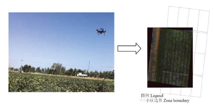
Fig. 1Used UAV in this study and one captured image
1.3 数据分析方法
首先,采用人工目视解译的方法从3个时期无人机影像中识别各小区棉花信息,以用于后期剔除土壤等背景;其次,设置剔除土壤背景、不剔除土壤背景等不同情景,分析剔除土壤背景对棉花冠层反射率的影响;然后,基于剔除土壤背景后的影像,提取其纹理特征,采用相关性分析方法探讨纹理特征与植株氮浓度之间的相关性;最后,设置不剔除土壤背景、剔除土壤背景、剔除土壤背景+增加纹理特征等不同情景,根据RedEdge M波段设置情况,选择常用光谱指数,计算相应光谱指数值,以其为输入变量,采用主成分回归法分别建立各情景下的植株氮浓度反演模型,并比较模型优劣。需要说明的是:(1)参考已有关于作物氮素营养诊断方面的报道[17,18],本研究使用的光谱指数包括比值光谱指数、土壤调整植被指数、改进土壤调整植被指数、三角植被指数、增强植被指数、修改三角植被指数、绿波段比值光谱指数、红边模型等常用光谱指数和以归一化差值植被指数为基础任意组合各波段信息构成的光谱指数,计算公式如表2所示;(2)主成分回归法是常用的遥感反演植被参数时的建模方法[28]。在建模时,获得的棉花3个时期共48个样本被随机分为2组。1组包含36个样本作为建模样本;另一组包含12个样本作为检验样本。各情境下的建模,依赖于相同的建模样本和检验样本。在构建主成分反演植株氮浓度模型时,选择恰能代表原输入变量99.5%以上信息的前n个主成分变量来建立模型,预测决定系数(coefficient of determination,R2)、预测标准误差(root mean square error,RMSE)和相对预测标准误差(RMSE/平均值×100%)被用来评价模型的优劣;(3)本研究使用的图像纹理特征主要依赖于灰度共生矩阵计算的各种参数,包括各波段的对比度、能量值、同质性、平均值和标准差等,利用Matlab软件编程实现相关计算。
Table 2 表2 表2本研究使用的光谱指数 Table 2Used spectral indices in this study
光谱指数 Spectral index
公式 Formula
发明者 Developed by
以归一化植被指数为构型的各光谱指数 Normalized Difference Vegetation Index Like Indices,NDVIs
A,B:孕蕾期;C,D:初花期;E,F:盛花期 Fig. 2True color synthetic images of cotton during different growth stages and changes in reflectance before and after soil background removal in corresponding periods
A:剔除土壤背景信息前的建模结果;B:剔除土壤背景信息前的验证结果;C:剔除土壤背景信息后的建模结果;D:剔除土壤背景信息后的验证结果;E:剔除土壤背景信息+增加纹理信息的建模结果;F:剔除土壤背景信息+增加纹理信息的验证结果 Fig. 4Prediction results of cotton plant nitrogen concentration under different scenarios
A: Calibration results before removing soil background; B: Validation results before removing soil background; C: Calibration results after removing soil background; D: Validation results after removing soil background; E: Calibration results after removing soil background and adding texture information; F: Validation results after removing soil background and adding texture information
WUW H . Plant Physiology. Beijing: Science Press, 2004: 91. (in Chinese) [本文引用: 1]
薛利红, 罗卫红, 曹卫星, 田永超 . 作物水分和氮素光谱诊断研究进展 遥感学报, 2003,7(1):73-80. DOI:10.11834/jrs.20030113Magsci [本文引用: 1] 水肥是影响作物生长的最主要限制因子之一,及时准确监测或诊断出作物水肥状况,对提高作物水肥管理水平和水肥利用效率,减少过度施肥带来的环境污染和指导节水农业生产具有重要意义,为此,首先简单介绍了植物光谱特性的生理生态基础以及光谱诊断原理,然后对国内外作物水分和氮素状况光谱诊断的研究进展,目前作物水分和氮素状况光谱诊断方面的研究重点以及存在的困难进行了评述,并提出了今后的研究方向和发展前景。 XUE LH, LUO WH, CAO WX, TIAN YC . Research progress on the water and nitrogen detection using spectral reflectance Journal of Remote Sensing, 2003,7(1):73-80. (in Chinese) DOI:10.11834/jrs.20030113Magsci [本文引用: 1] 水肥是影响作物生长的最主要限制因子之一,及时准确监测或诊断出作物水肥状况,对提高作物水肥管理水平和水肥利用效率,减少过度施肥带来的环境污染和指导节水农业生产具有重要意义,为此,首先简单介绍了植物光谱特性的生理生态基础以及光谱诊断原理,然后对国内外作物水分和氮素状况光谱诊断的研究进展,目前作物水分和氮素状况光谱诊断方面的研究重点以及存在的困难进行了评述,并提出了今后的研究方向和发展前景。
JUNG JH, MAEDAM, CHANG AJ, LANDIVARJ, YEOMJ, MCGINTYJ . Unmanned aerial system assisted framework for the selection of high yielding cotton genotypes Computers and Electronics in Agriculture, 2018,152:74-81. DOI:10.1016/j.compag.2018.06.051URL [本文引用: 1]
XIAO JJ, HUO ZG, YAO YP, ZHANGL, LIN, BAI QF, WEN QP . Meteorogical grading indexs of water-saving irrigation for cotton Acta Ecologica Sinica, 2013,33(22):7288-7299. (in Chinese) [本文引用: 1]
TREMBLAYN. Determining nitrogen requirements from crops characteristics. Benefits and challenges//PANDALAI S G. Recent Research Developments in Agronomy and Horticulture: vol 1. Kerala: India Research Signpost Press, 2004: 157-182. [本文引用: 1]
CHEN PF, SUN JL, WANG JH, ZHAO CJ . Using remote sensing technology for crop nitrogen diagnosis: Status and trends Scientia Sinica (Informationis), 2010,40(S1):21-37. (in Chinese) [本文引用: 1]
HANSEN PM, SCHJOERRING JK . Reflectance measurement of canopy biomass and nitrogen status in wheat crops using normalized difference vegetation indices and partial least squares regression Remote Sensing of Environment, 2003,86(4):542-553. DOI:10.1016/S0034-4257(03)00131-7URL [本文引用: 1]
EITEL J UH, LONG DS, GESSLER PE, SMITH A MS . Using in-situ measurements to evaluate the new RapidEyeTM satellite series for prediction of wheat nitrogen status International Journal of Remote Sensing, 2007,28(18):4183-4190. DOI:10.1080/01431160701422213URL [本文引用: 1]
CHEN PF, DRISSH, TREMBLAYN, WANG JH, VIGNEAULTP, LI BG . New index for estimating crop nitrogen concentration using hyperspectral data Remote Sensing of Environment, 2010,114(9):1987-1997. DOI:10.1016/j.rse.2010.04.006URL [本文引用: 1]
HUANG SY, MIAO YX, YUANF, GNYP ML, YAO YK, CAOQ, WANG HY , LENZ-WIEDEMANNV I S, BARETHG . Potential of rapidEye and worldView-2 satellite data for improving rice nitrogen status monitoring at different growth stages Remote Sensing, 2017,9(3):227. DOI:10.3390/rs9030227URL [本文引用: 1]
LIANGL, DI LP, HUANGT, WANG JH, LINL, WANG LJ, YANG MH . Estimation of leaf nitrogen content in wheat using new hyperspectral indices and a random forest regression algorithm Remote Sensing, 2018,10(12):1940. DOI:10.3390/rs10121940URL [本文引用: 1]
TIAN ML, BAN ST, CHANG QR, YOU MM, LUOD, WANGL, WANGS . Use of hyperspectral images from UAV-based imaging spectroradiometer to estimate cotton leaf area index Transactions of the Chinese Society of Agricultural Engineering, 2016,32(21):102-108. (in Chinese) [本文引用: 1]
QIN ZF, CHANG QR, XIE BN, SHENJ . Rice leaf nitrogen content estimation based on hysperspectral imagery of UAV in Yellow River diversion irrigation district Transactions of the Chinese Society of Agricultural Engineering, 2016,32(23):77-85. (in Chinese) [本文引用: 2]
LIU HY, ZHU HC, WANGP . Quantitative modelling for leaf nitrogen content of winter wheat using UAV-based hyper-spectral data International Journal of Remote Sensing, 2017,38(8/10):2117-2134. DOI:10.1080/01431161.2016.1253899URL [本文引用: 2]
N?SIR, VILJANENN, KAIVOSOJAJ, ALHONOJAK, HAKALAT, MARKELINL, HONKAVAARAE . Estimating biomass and nitrogen amount of barley and grass using UAV and aircraft based spectral and photogrammetric 3D features Remote Sensing, 2018,10(7):1082. DOI:10.3390/rs10071082URL [本文引用: 1]
ZHANG ZT, BIANJ, HAN WT, FU QP, CHEN SB, CUIT . Diagnosis of cotton water stress using unmanned aerial vehicle thermal infrared remote sensing after removing soil background Transactions of the Chinese Society for Agricultural Machinery, 2018,49(10):250-260. (in Chinese) [本文引用: 1]
ZHUY, YAOX, TIAN YC, LIU XJ, CAO WX . Analysis of common canopy vegetation indices for indicating leaf nitrogen accumulations in wheat and rice International Journal of Applied Earth Observation and Geoinformation, 2008,10(1):1-10. DOI:10.1016/j.jag.2007.02.006URL [本文引用: 1]
CHEN PF . A comparison of two approaches for estimating the wheat nitrogen nutrition index using remote sensing Remote Sensing, 2015,7(4):4527-4548. DOI:10.3390/rs70404527URL [本文引用: 1]
ROUSE JW, HAAS RW, SCHELL JA, DEERING DW, HARLAN JC . Monitoring the vernal advancement and retrogradation (green wave effect) of natural vegetation NASA/GSFCT Type III Final Report, USA: NASA, 1974. [本文引用: 1]
PEARSON RL, MILLER LD . Remote mapping of standing crop biomass for estimation of the productivity of the Shortgrass Prairie, Pawnee National Grasslands, Colorado//Proceedings of the Eighth International Symposium on Remote Sensing of Environment Ann Arbor, Michigan, USA, 1972: 1357-1381. [本文引用: 1]
HUETEA, JUSTICEC, LIUH . Development of vegetation and soil indices for MODIS-EOS Remote Sensing of Environment, 1994,49(3):224-234. DOI:10.1016/0034-4257(94)90018-3URL [本文引用: 1]
BROGE NH, LEBLANCE . Comparing prediction power and stability of broadband and hyperspectral vegetation indices for estimation of green leaf area index and canopy chlorophyll density Remote Sensing of Environment, 2001,76(2):156-172. DOI:10.1016/S0034-4257(00)00197-8URL [本文引用: 1]
QIJ, CHEHBOUNIA, HUETE AR, KERR YH, SOROOSHIANS . A modified soil adjusted vegetation index Remote Sensing of Environment, 1994,48(2):119-126. DOI:10.1016/0034-4257(94)90134-1URL [本文引用: 1]
RONDEAUXG, STEVENM, BARETF . Optimization of soil- adjusted vegetation indices Remote Sensing of Environment, 1996,55(2):95-107. DOI:10.1016/0034-4257(95)00186-7URL [本文引用: 1]
HABOUDANED, MILLER JR, PATTEYE , ZARCO-TEJADAP J, STRACHANI B . Hyperspectral vegetation indices and novel algorithms for predicting green LAI of crop canopies: Modeling and validation in the context of precision agriculture Remote Sensing of Environment, 2004,90(3):337-352. DOI:10.1016/j.rse.2003.12.013URL [本文引用: 1]
GITELSON AA , VI?AA, CIGANDAV, RUNDQUISTD C, ARKEBAUERT J . Remote estimation of canopy chlorophyll content in crops Geophysical Research Letters, 2005,32(8):93-114. [本文引用: 1]
XUE LH, CAO WX, LUO WH, DAI TB, ZHUY . Monitoring leaf nitrogen status in rice with canopy spectral reflectance Agronomy Journal, 2004,96(1):135-142. DOI:10.2134/agronj2004.0135URL [本文引用: 1]
YANGF, SUN JL, FANG HL, YAO ZF, ZHANG JH, ZHU YQ, SONG KS, WANG ZM, HU MG . Comparison of different methods for corn LAI estimation over northeastern China International Journal of Applied Earth Observation and Geoinformation, 2012,18:462-471. DOI:10.1016/j.jag.2011.09.004URL [本文引用: 1]
LI JT, SHI YY , VEERANAMPALAYAM-SIVAKUMARA N, SCHACHTMAND P . Elucidating sorghum biomass, nitrogen and chlorophyll contents with spectral and morphological traits derived from unmanned aircraft system Frontiers in Plant Science, 2018,9:1406. DOI:10.3389/fpls.2018.01406URL [本文引用: 1]
ZHANG DY . Diagnosis mechanism and methods of crop chlorophyll information based on hyperspectral imaging technology [D]. Hangzhou: Zhejiang University, 2012. (in Chinese) [本文引用: 1]

 新窗口打开|下载原图ZIP|生成PPT
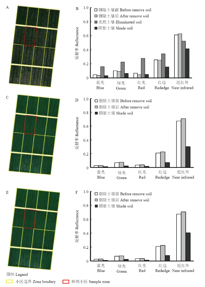 新窗口打开|下载原图ZIP|生成PPT
 新窗口打开|下载原图ZIP|生成PPT
 新窗口打开|下载原图ZIP|生成PPT
