 ,1, 寇志翔1,2, 胡宇凡1,2, 张百平1
Spatial distribution patterns of Pinus tabulaeformis forest and Pinus massoniana forest in Qinling-Daba Mountains and the boundary of subtropical and warm temperate zones
YAO Yonghui,1, KOU Zhixiang1,2, HU Yufan1,2, ZHANG Baiping1收稿日期:2019-04-8修回日期:2020-02-18网络出版日期:2020-11-25
| 基金资助: |
Received:2019-04-8Revised:2020-02-18Online:2020-11-25
| Fund supported: |
作者简介 About authors
姚永慧(1975-), 女, 湖北安陆人, 博士, 副研究员, 研究方向为地理时空数据分析。E-mail:

摘要
关键词:
Abstract
Keywords:
PDF (4387KB)元数据多维度评价相关文章导出EndNote|Ris|Bibtex收藏本文
本文引用格式
姚永慧, 寇志翔, 胡宇凡, 张百平. 秦巴山区马尾松林和油松林的空间分布及亚热带与暖温带界线划分. 地理学报[J], 2020, 75(11): 2298-2306 doi:10.11821/dlxb202011002
YAO Yonghui, KOU Zhixiang, HU Yufan, ZHANG Baiping.
1 引言
秦岭不仅是中国南北的地理分界线,也是中国亚热带和暖温带的气候分界线。刘慎谔在研究中国北部及西部植物地理时指出:“秦岭之南俨然已进入南方植物境内,东南以伏牛山及淮河为界线”,这一观点成为以后中国北部—西部植物分区的基础[1]。1958年竺可桢先生在进行气候区划时,以10 ℃以上积温4500~8000 ℃、最冷月气温2~16 ℃、无霜期240~260 d为指标,将淮河—秦岭—白龙江一带确定为中国亚热带的北界[2]。这一界线符合当时全国农业发展纲要中“每亩平均年产量分别达到五百斤”和“每亩平均年产量分别达到八百斤”的界线,靠近一年两熟的北界[2];符合中国传统农业中南方稻田和北方旱作的界线[3];体现了淮南为桔、淮北为枳的地理生态现象。这一界线成为中国生物气候分带和地理格局划分的主要依据,但学术界关于这一南北地理—生态分界线的具体位置一直有争论。一方面,秦岭山体巨大,峰峦叠障,北坡短而陡峻,河流深切,形成许多峡谷,南坡则相对长而和缓,有许多条近于东西向的山岭和山间盆地[4];南北跨度宽达200~300 km,导致分界线的具体位置众说纷纭[5]。另一方面,由于不同的研究领域对这一界线的划分目的、划分指标和方法上都有差异,因此对于分界线的具体位置,历来存在着3种划分方法[5]:秦岭北麓[6,7]、秦岭主山脊线[8,9,10,11]和秦岭南坡下部海拔约1000 m处[5, 12-15]。更有****认为秦岭不是中国北亚热带和暖温带的分界线,而应作为暖温带和温带植物的分界线[16,17,18,19,20]。
这种划分差异虽然跟研究深入程度、认识问题的角度和划分的具体依据与划分目的等有关,但主要与过渡带的复杂性、过渡性和异质性等有关。一方面,由于早期划分时数据的限制,划分的指标有明显的局限性。另一方面,以往在该区域的研究一直存在“碎片化”和“局域化”问题,大多数调查和研究主要集中在陕西的秦岭一带,对过渡带的整体特征、结构和机理缺乏统一的认识。此外,秦巴山区是中国生物特有种比例最高的地区[18],其生物多样性具有高度的复杂性和异质性,但目前对其认识严重不足。在当前大数据条件下,综合分析植被分布数据、气候数据等可以更精确地研究过渡带特征,包括它的气候、植被、土壤、山体结构等及其相互作用,从而进一步明确秦巴山地在中国地理—生态格局中的特殊地位和作用。因此,本文在“中国南北过渡带综合科学考察项目”野外调查基础上,选择马尾松(Pinus massoniana)林和油松(Pinus tabulaeformis)林这两类分别代表中国南方亚热带针叶林和北方温带针叶林的植被,结合研究区SRTM DEM数据、worldclimate气候数据(气温和降水数据)等,以年降水、最冷月(1月)气温、最热月(7月)气温和年均温为气候指标,详细分析这两类针叶林在秦巴山区的空间分布及气候条件对马尾松林和油松林空间分布规律的影响机制,探讨秦巴山区植被与气候的相关关系,从而为中国亚热带和温带的界线划分提供一定的科学依据。
2 研究区概况
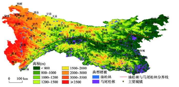
秦巴山地是横贯中国中部东西向延伸的重要山地,在全国地理—生态格局中具有特别突出的位置和意义,也被称为中国南北过渡带(图1)。本文中,秦巴山地以秦岭和大巴山为主体,还包括东部的豫西低山丘陵、鄂西北中低山及丘陵地区以及西部的太子山、迭山、岷山、龙门山等,跨越陕西、甘肃、四川、重庆、湖北、河南等六省市[21];从甘肃的迭部向东延伸到湖北的神农架,东西长约1000 km,面积约30万km2。一方面,由于位于中纬度地区,受大陆性气候和季风性气候的双重影响[16],秦岭屏蔽了北方冷空气南下,又阻挡了东南暖湿气流北上,秦岭南北坡的气候条件迥异;另一方面,山地被称为生物迁移的障碍或桥梁[22,23],秦巴山地是中国生物东西向和南北方向迁移的通道,物种分布具有明显的多样性、复杂性和过渡性。纬向地带性、海陆位置、垂直地带性、坡向分异甚至地表物质差异、人类活动因素等相互作用、相互影响、交织叠加,形成了秦巴山区极其复杂的山地环境并表现出明显的过渡特征。图1
 新窗口打开|下载原图ZIP|生成PPT
图1秦巴山区的地形特征及马尾松林和油松林的空间分布
Fig. 1Topographic map of Qinling-Daba Mountains and the spatial distribution of P. massoniana forest and P. tabulaeformis forest
3 数据来源与研究方法
3.1 数据来源
3.1.1 马尾松林和油松林的空间分布数据 《中国1∶1000000植被类型图》[11]扫描数字化后,提取马尾松林和油松林的空间分布及面积、类型等信息。两类植被的空间分布数据主要用来分析秦巴山区亚热带与暖温带典型针叶林的空间分布规律及二者的分界线。3.1.2 气候数据 气候数据下载自
3.1.3 数字高程(DEM)数据 采用空间信息联盟(CGIAR-CSI)提供的SRTM 90 m数字高程数据库中的DEM数据,空间分辨率为90 m。SRTM数据主要用来分析马尾松林和油松林分布的高度信息。
3.2 研究方法
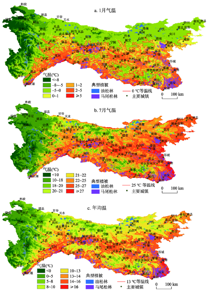
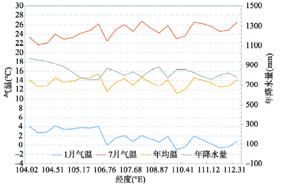
油松林是华北地区的代表性针叶林类型,也是温性针叶林中分布最广的植被类型,其西南界线为秦巴山地海拔1000~1600 m地段。马尾松林是中国东南部湿润亚热带地区分布最广、资源量最大的植被类型,也是这一地区的典型代表性植被;它分布的北界为秦岭—伏牛山—淮河一线,与暖温带油松林相衔接;马尾松林的垂直分布,在秦岭南坡和大巴山多分布在海拔1000 m以下。已有的研究表明,马尾松林和油松林的分布区大致在秦岭地区重叠[16, 18],但二者具体的交汇过渡界线及其与水热条件的关系尚未有详细具体的分析。本文根据ArcGIS的空间分析方法,将马尾松林和油松林的空间分布数据与地形数据(SRTM)叠加,而获取两类针叶林的分布范围及分布的海拔高度信息,在此基础上绘制了二者的分界线(图1)。同时,为了进一步分析气候对两类针叶林分布的影响机制,根据worldclimate气候数据(根据1950—2000年气象台站数据进行多年平均并空间内插生成,空间分辨率1 km),提取了研究区的等温线和等雨线等信息并绘制了研究区年降水、最冷月气温、最热月气温和年均温的空间分布图(图2、图3);并将2类针叶林数据与气候数据叠加,从而分析气候条件对马尾松林和油松林空间分布的影响。在此基础上,沿马尾松林和油松林的分界线处作了气温(1月气温、7月气温和年均温)与降水的剖面图(图4)并对剖面上的各个气候指标进行了统计分析(表1),研究二者分界线处气候指标的变化情况,从而获得秦巴山区亚热带和暖温带针叶林过渡带处的气候指标。
图2
 新窗口打开|下载原图ZIP|生成PPT
图2秦巴山区年降水空间分布
Fig. 2Spatial distribution of annual precipitation in Qinling-Daba Mountains
图3
 新窗口打开|下载原图ZIP|生成PPT
图3秦巴山区气温分布
Fig. 3Temperature distribution maps of Qinling-Daba Mountains
图4
 新窗口打开|下载原图ZIP|生成PPT
图4马尾松林和油松林分界线处的气温和降水剖面
Fig. 4Temperature and precipitation profiles at the boundary between P. massoniana forest and P. tabulaeformis forest
Tab. 1
表1
表1马尾松和油松林分界线处的气温与降水指标
Tab. 1
| 气候指标 | 1月气温(℃) | 7月气温(℃) | 年均温(℃) | 年降水量(mm) |
|---|---|---|---|---|
| 分布范围 | 0~4 | 22~26 | 12~14 | 750~1000 |
新窗口打开|下载CSV
4 结果与分析
4.1 秦巴山区马尾松林和油松林的空间分布特征
秦巴山区马尾松林和油松林的空间分布具有明显的地域分异规律,地形尤其是海拔高度对二者的分布具有重要的影响:马尾松林主要分布于秦巴山地南部海拔低于1000 m的地区,而油松林则主要分布于秦巴山地北部1000 m以上的地区,二者的分布大致以南召—商南—洋县—略阳—青川为分界线(图1)。马尾松林与油松林的这条分布界线自东向西展布并逐渐向西南倾斜,东部的界线大致在33.45°N,马尾松林分布于伏牛山南坡1000 m以下的地区;中部的界线大致为汉中盆地的北缘(33.28°N)高度约1000 m处;西部的界线大致以川西1200 m的山地为界线(32.70°N);即二者的分界线在伏牛山南坡至汉中盆地北缘(秦岭南坡)海拔1000~1200 m处。一方面,秦巴山区的地形自东向西海拔逐渐升高,地形高度的变化引起水热条件的变化,这是马尾松林与油松林空间分异的主要影响因素;另一方面,由于马尾松林和油松林各自垂直分布的高度基本上以海拔1000 m为分界线,因此二者的分界线呈自东向西展布并逐渐向西南倾斜的状态。4.2 秦巴山区马尾松林和油松林空间分布与气候的协同变异规律
秦巴山区年降水的空间分布如图2所示,马尾松林和油松林的分布与降水具有密切的关系。该区域年降水量自南部向北部和西北部逐渐降低,汉中盆地尤其是汉水谷地以南的广大地区,年降水量基本上在900 mm以上;研究区的西北部、东北部及秦岭北坡部分地区的年降水量在400~800 mm之间。从秦巴山区800 mm等雨线的分布来看,东部地区800 mm等雨线的分布范围变化较大,伏牛山一带、商南—淅川、郧县、山阴等地的山区年降水量均在800 mm以上;中部地区800 mm等雨线位于秦岭的北坡;而西部地区800 mm等雨线沿太白县北部—留坝—青川—平武一线自东北向西南展布(图2)。油松林主要分布于年降水量小于800 mm的地区,而马尾松林主要分布于年降水量大于800 mm的地区。同样地,研究区马尾松林和油松林的分布也与最冷月气温、最热月气温和年均温具有很好的相关关系。从最冷月气温的空间分布来看,东部南召—西峡—商南—郧县一线以南的地区、中部旬阳—镇安—宁陕—洋县留坝一线以南的地区、西部成县—武都—文县—平武一线以南的地区最冷月气温均在0 ℃以上,即秦岭的南坡及以南地区(除米仓山、大巴山和神农架部分山区外)最冷月气温基本上都在0 ℃以上。根据油松林和马尾松林与最冷月气温的相关关系来看,除神农架外,马尾松林完全分布于最冷月气温在0 ℃以上的区域,而油松林则全部分布于最冷月气温在0 ℃以下的地区(图3a)。
最热月除西部部分高山区外,整个秦巴山区的气温均在10 ℃以上;区域内海拔1000 m以下的地区气温基本上在25 ℃以上,而马尾松林基本上分布在这个温度范围内;油松林则主要分布于最热月气温在24 ℃以下的区域(图3b)。
从年均温的空间分布特征来看,除研究区西部山区、秦岭、大巴山和神农架的部分高海拔地区(2000 m以上)外,秦巴山区的大部分地区的年均温都在10 ℃以上;自西向东,平武—青川—勉县—洋县(汉中盆地北缘)—石泉—旬阳—郧县—西峡—南召一线以南的地区,年均气温可达13 ℃以上(图3c)。从马尾松林和油松林与年均温的空间分布关系来看,马尾松林基本上分布在年均温高于13 ℃的地区,油松林则正好相反。
4.3 马尾松林和油松林分界线处气候特征
从马尾松林和油松林分界线处的气候剖面分析结果来看(图4、表1),分界线处的气温和降水指标都比较稳定,首先,最冷月气温在剖面西部(106°E以西)为2~4 ℃,在剖面中部和东部(106°E以东)为0~2 ℃;其次,最热月气温在剖面西部(105°E以西)为22~24 ℃,在剖面中部和东部(105°E以东)为24~26 ℃;第三,剖面处的年均温基本上界于12~14 ℃之间;另外,年降水在剖面的西部(105°E以西)为800~1000 mm,在剖面的中部和东部(105°E以东)界于750~900 mm之间。5 结论与讨论
5.1 讨论
5.1.1 秦巴山区亚热带和暖温带界线划分的指标 以往研究中划分亚热带与暖温带界线的指标通常为气候指标,如≥ 10 ℃的积温[2]、≥ 10 ℃天数[25,26,27,28]或温暖指数(WI)[20];也有部分研究以植被物种和结构、植物区系优势类群、土壤等作为划分指标[5, 12-15]。因为选择的划分指标不同,所划分界线的位置也不尽相同并引起争议。从植被与气候的关系出发,选择适宜的植被—气候指标应该比单纯考虑气候要素或植被要素更能全面地反映地表格局的变化。本文研究也表明:在秦巴山区,亚热带典型针叶林(马尾松林)与温带典型针叶林(油松林)之间具有很明确的地理分界线,而这条分界线处的气候指标(年降水量、年均温、最冷月气温和最热月气温)的变化范围也很稳定,因此选择亚热带和暖温带代表性植被—气候指标可以更科学的划分气候带的界线。5.1.2 秦巴山区亚热带与暖温带分界线的位置 如前所述,目前关于亚热带与暖温带气候分界线的位置主要有3种观点:秦岭北麓[6,7]、秦岭主山脊线[8,9,10,11]、秦岭南坡下部海拔约1000 m处[5, 12-15]。本文中亚热带与暖温带针叶林的界线也位于秦岭南坡1000~1200 m处,与亚热带和暖温带分界线位于秦岭南坡1000 m处的观点基本一致。但亚热带与暖温带针叶林的分界线并不代表就是亚热带和暖温带的分界线,因为针叶林、阔叶林等不同植被类型的分布范围和相互之间的分界线是不同的,根据植被气候指标划分的亚热带与暖温带界线应该是由这些不同类型植被的分界线(亚热带与暖温带针叶林分界线、阔叶林分界线、灌丛分界线等)组成的一个过渡带。因此,在划分亚热带与暖温带界线时,需要综合考虑不同气候带内针叶林、阔叶林、灌木林甚至是草本植被的空间分布情况和相互之间的过渡情况。
5.2 结论
(1)马尾松林和油松林的分界线及相应位置的年降水、年均温、最冷月气温和最热月气温可以作为亚热带与暖温带界线划分的植被—气候指标之一。秦巴山区亚热带针叶林与温带针叶林的分界线位于伏牛山南坡至秦岭南坡(汉中盆地北缘沿线)海拔1000~1200 m处;分界线处气候指标稳定:年降水750~1000 mm,年均温12~14 ℃,最冷月气温0~4 ℃,最热月气温22~26 ℃。(2)通过综合考虑植被—气候指标来划分秦巴山区亚热带和暖温带的界线,能更科学地界定气候带分界线的位置及过渡带的特征。此外,秦巴山区亚热带与暖温带界线应该是由亚热带与暖温带针叶林分界线、阔叶林分界线和灌丛分界线等组成的一个过渡带。
参考文献 原文顺序
文献年度倒序
文中引用次数倒序
被引期刊影响因子
[本文引用: 1]
[本文引用: 1]
[本文引用: 3]
[本文引用: 3]
[本文引用: 1]
[本文引用: 1]
[本文引用: 1]
[本文引用: 1]
[本文引用: 5]
[本文引用: 5]
[本文引用: 2]
[本文引用: 2]
[本文引用: 2]
[本文引用: 2]
[本文引用: 2]
[本文引用: 2]
[本文引用: 2]
[本文引用: 2]
[本文引用: 2]
[本文引用: 2]
[本文引用: 3]
[本文引用: 3]
[本文引用: 3]
[本文引用: 3]
[本文引用: 3]
[本文引用: 3]
[本文引用: 3]
[本文引用: 3]
[本文引用: 1]
[本文引用: 1]
[本文引用: 3]
[本文引用: 3]
[本文引用: 1]
[本文引用: 1]
[本文引用: 2]
[本文引用: 2]
[本文引用: 1]
[本文引用: 1]
[本文引用: 1]
DOI:10.1002/fee.1280URL [本文引用: 1]
DOI:10.1002/(ISSN)1097-0088URL [本文引用: 1]
[本文引用: 1]
[本文引用: 1]
URL [本文引用: 1]

Accumulated temperature is a basic specialized term in agrometeorology and other relative subjects which often occurs in papers of different journals. But there has been a big confusion of its scientificalness and unit for hundred years. Its origin,development,problem of scientificalness and improvement were reviewed in this paper. J.L.Monteith's theory was particularly introduced,in which the essential aspect of thermal time was discovered and explained. Paper titles with term of accumulated temperature and other terms with the same meaning i.e. thermal time,degree-day and heat unit in CAB Literature from 1990 to Oct. 2008 were retrieved. Results showed that there were less and less scientists using accumulated temperature,most using degree-day but more and more using thermal time. Considering the term of accumulated temperature had been using in China for dozens years and was very popular,in order to solve the problem of scientificalness and to keep agreed with physical principles,it was suggested to be replaced by "integrated temperature" ,which had the same Chinese characters and pronunciation,and the unit of "℃" should be also replaced by "℃·d". At the same time,the term explanation of "heat resource" in revised edition of Chinese Agronomic Terms(1993)was renewed as the following:a type of climatic resource different with heat energy in physics,i.e. combination of usable temperature conditions in agriculture and its continued time,usually expressed as integration of temperature to time.
[本文引用: 1]
DOI:10.11821/xb201001002URL [本文引用: 1]
A new scheme for climate regionalization in China was established based on the daily observations for 609 meteorological stations during the period 1971-2000.During regionalization,current basic theories,classification methodologies and criteria system were used,besides,five principles were taken into consideration,mainly included zonal and azonal integration,genetic unity and regional relative consistent climate integration,comprehensiveness and leading factors integration,bottom-up and top-down integration,spatial continuity and small patch omission.The new scheme consists of 12 temperature zones,24 moisture regions and 56 climatic sub-regions.
[本文引用: 1]
DOI:10.11676/qxxb1982.004URL [本文引用: 1]
By analysing a large amount of data, it is found that in our country which is located in the middle and lower latitudes with great disparity in topography, the using of the number of days with temperature l00℃ as an index to divide the climatic zones is much better in revealing horizontal and vertical zonality. For the third class, the climatic regions are divided with a unified index(July temperature).The improvements made are also disscussed.
[本文引用: 1]
