 ,1, 翟俊,2, 祝萍1,3, 郑瑜晗1,3
Spatiotemporal evolution characteristics of livestock-carrying pressure in China and its implications for grassland ecosystem conservation pattern
HUANG Lin,1, ZHAI Jun,2, ZHU Ping1,3, ZHENG Yuhan1,3通讯作者:
收稿日期:2019-09-9修回日期:2020-08-11网络出版日期:2020-11-25
| 基金资助: |
Received:2019-09-9Revised:2020-08-11Online:2020-11-25
| Fund supported: |
作者简介 About authors
黄麟(1981-), 女, 副研究员, 主要从事土地利用变化及其生态效应研究。E-mail:

摘要
关键词:
Abstract
Keywords:
PDF (4048KB)元数据多维度评价相关文章导出EndNote|Ris|Bibtex收藏本文
本文引用格式
黄麟, 翟俊, 祝萍, 郑瑜晗. 中国草畜平衡状态时空演变指示的草地生态保护格局. 地理学报[J], 2020, 75(11): 2396-2407 doi:10.11821/dlxb202011009
HUANG Lin, ZHAI Jun, ZHU Ping, ZHENG Yuhan.
1 引言
20世纪70年代以来,青藏高原、内蒙古草原、天山北坡等草原区出现大面积可利用天然草地退化[1,2,3]。草地退化具有明显的区域差异,湿润半湿润草甸类草地发生着草地破碎化先导,随后覆盖度持续降低,最后形成黑土滩的退化过程,而干旱半干旱草原类草地发生着覆盖度持续降低,最后形成沙地和荒漠化草地的退化过程[4,5,6]。因此,草地退化既是植被退化,亦是土壤退化,后者为核心问题[7]。随着草地退化程度的加重,植被覆盖度、生产力、优良牧草地上与地下生物量逐渐下降,植被演替过程受到强烈抑制[8,9,10],土壤有机质、酶活性、微生物群落等逐渐降低[11,12,13],草地牧草供给、碳固定、水源涵养、防风固沙等服务能力下降[14,15,16],生物多样性降低[17]。草地退化或恢复受自然因素和人类活动影响[18]。气候变暖、降水量变化引起返青期提前与生长季延长[19,20,21],以及植物物种丰富度、土壤养分变化[22,23],皆影响草地植被生产力。长期超载过牧产生的草畜矛盾是导致草地退化最主要的人类活动因素[1, 5, 24-25]。中国大部分天然草地载畜量超过其最大承载能力,比如青海超载率为27%、西藏为89%[25],内蒙古则高达102%[26]。放牧时间长、压力大,导致冷季草地退化尤为严重[24]。温性草原类、高寒草甸类的地上和地下生物量均随放牧强度增加而下降,过度放牧导致草原地下生物量降低30%~50%[25, 27]。
退牧还草、草原生态保护补助奖励等生态保护与修复措施的持续实施,通过禁牧与轮牧、封育与自然恢复、补播、人工或半人工种草、控制毒杂草与鼠虫危害等措施恢复草地[5, 28-29],内蒙古锡林郭勒盟、青海三江源区、黄土高原区等地区的退化草地恢复态势明显[18, 30-31]。围栏封育、禁牧对退化草地土壤、植被覆盖度、生物量、生物多样性有积极作用[32,33,34],但对生态系统稳定性有负面影响,需要确定合理封育时间并开展合理利用[28, 30, 33-34]。
草畜平衡是一个理想状态,通过实施以草定畜、保持合理载畜量,调节草地牧草供给量和牲畜饲草需求量之间的平衡,优化放牧策略以快速应对草地变化[35]。通过草畜平衡分析还可为草原生态保护策略的制定提供科学依据[26, 36]。传统草畜平衡分析方法主要利用草地产量、利用率与牲畜数进行估算[37],多数研究基于植被指数线性关系或生产力模型估算理论产草量,结合牲畜数确定理论载畜量,分析区域草畜平衡状况[36, 38-39]。此外,不少研究也聚焦野生食草动物对三江源、阿尔金等生态保护区草畜平衡的影响[40,41]。
保护与修复草地生态系统对于中国草原牧区生态安全屏障构建和现代畜牧业的发展极为重要。解决草地生态保护与生产利用之间的矛盾,需要从“以生态治理为主的应急抢救”向“生态可持续的长效机制”转变,科学合理地规划草地生态与生产功能。因此,需要了解时空尺度上草地及其牧草供给服务、草地载畜压力如何变化?如何实现草畜平衡以达到草地生态保护与经济发展双赢目标?本文分析了大时空尺度下的草地植被覆盖、牧草供给、草畜平衡状态时空变化,探讨草地退化与恢复及载畜压力下主要草原牧区草地生态系统保护与恢复空间格局,进而提出具有区域针对性、可持续性的生态保护与生产利用策略及建议。
2 数据与方法
2.1 研究区草地资源概况
本文选择内蒙古自治区、新疆维吾尔自治区、西藏自治区、青海省、甘肃省等作为研究区,草地面积分别约占全国草地面积的20%、12.6%、26.7%、15.7%、4.0%[22],分别约占该省域国土面积的67%、35%、72%、51%、55%,其中可利用草地面积分别约占该省域草地面积的81%、84%、88%、92%、90%。本文将天然草地划分为温性草原类、温性草甸类、温性荒漠类、高寒草原类、高寒草甸类、高寒荒漠类等6大类。2.2 基于LUCC、植被覆盖度变化的草地退化与恢复信息提取
基于不同草地类型的生态学特性,借鉴刘纪远等[4]、徐新良等[31]、高清竹等[42]、杨峰等[3]、艳燕等[43]在青藏高原、内蒙古、新疆等区域开展的草地退化与恢复遥感信息提取方法,依据《天然草地退化、沙化、盐渍化的分级指标(GB19377-2003)》、草地退化/恢复遥感解译和草地变化态势遥感解译分类系统[31],建立基于植被覆盖度变化的草地退化与恢复遥感分类体系,将不同类型草地退化划分为轻度、中度、重度,恢复划分为轻微、明显、极显著好转(表1)。Tab. 1
表1
表1基于植被覆盖度变化的草地退化与恢复分类
Tab. 1
| 草地类型 | 覆盖度变化(%) | 退化与恢复类型 | 草地类型 | 覆盖度变化(%) | 退化与恢复类型 | ||
|---|---|---|---|---|---|---|---|
| 温性草原类 | 减少 | 10~20 | 轻度退化 | 高寒草原类 | 减少 | 10~20 | 轻度退化 |
| 20~40 | 中度退化 | 20~30 | 中度退化 | ||||
| ≥ 40 | 重度退化 | ≥ 30 | 重度退化 | ||||
| 增加 | 10~20 | 轻微好转 | 增加 | 10~20 | 轻微好转 | ||
| 20~40 | 明显好转 | 20~40 | 明显好转 | ||||
| ≥ 40 | 极显著好转 | ≥ 40 | 极显著好转 | ||||
| 温性草甸类 | 减少 | 10~20 | 轻度退化 | 高寒草甸类 | 减少 | 10~20 | 轻度退化 |
| 20~40 | 中度退化 | 20~40 | 中度退化 | ||||
| ≥ 30 | 重度退化 | ≥ 40 | 重度退化 | ||||
| 增加 | 10~20 | 轻微好转 | 增加 | 10~20 | 轻微好转 | ||
| 20~40 | 明显好转 | 20~40 | 明显好转 | ||||
| ≥ 30 | 极显著好转 | ≥ 40 | 极显著好转 | ||||
| 温性荒漠类 | 减少 | 5~15 | 轻度退化 | 高寒荒漠类 | 减少 | 5~10 | 轻度退化 |
| 15~40 | 中度退化 | 10~20 | 中度退化 | ||||
| ≥ 40 | 重度退化 | ≥ 20 | 重度退化 | ||||
| 增加 | 5~15 | 轻微好转 | 增加 | 5~10 | 轻微好转 | ||
| 15~40 | 明显好转 | 10~20 | 明显好转 | ||||
| ≥ 40 | 极显著好转 | ≥ 20 | 极显著好转 | ||||
新窗口打开|下载CSV
利用土地利用/覆被变化数据库的本底与动态成分数据,提取2000—2015年草地与其他类型的相互转换数据,以及不同覆盖度草地动态变化数据。土地利用/覆被数据包括6个一级类型,是以陆地卫星TM/ETM+、中巴资源卫星、环境卫星图像数据作为信息源,通过人工解译获得,综合评价精度达到94.3%[44]。
采用像元二分法,利用经过S-G滤波处理的MODIS归一化植被指数(NDVI)数据产品计算2000—2015年每月植被覆盖度,空间分辨率1 km。基于上述草地类型转换、不同覆盖度草地动态变化,结合植被覆盖度变化,同时运用Sen趋势度和Mann-Kendall趋势检验相结合的方法,获得大时空尺度草地退化与恢复信息。
2.3 草地牧草供给量估算方法
牧草供给(Y)是草地的重要供给功能,是草地畜牧业生产的物质基础[45]。除天然草原牧草供给以外,还有人工草地、秸秆、青贮、粮食等补充饲草料。首先,获取了NASA-CASA模型模拟的2000—2015年每月草地植被净初级生产力(NPP)数据,空间分辨率为1 km。然后,利用地面实测草地生物量数据开展模型模拟结果验证,结果具有较好的准确性[46]。基于地上地下生物量比,结合草地类型空间分布、草地资源调查数据,利用NPP数据估算2000—2015年天然草地产草量[36, 45],公式为:
式中:Yn为单位面积天然草地产草量(kg/hm2);r为草地植被地上/地下生物量比例,不同类型n取值参考沈海花等[22]、马安娜等[47];t是生物量转换为生产力的系数,取值0.45。
2.4 草地载畜压力估算与草畜平衡状态评价
利用草地载畜压力指数算法[24, 36],通过现实载畜量(Cs)和理论载畜量(Cl)之比得到2000—2015年草地载畜压力指数(IP),进而分析草畜平衡状态。式中:CS即单位面积草地实际承载的羊单位数量(标准羊单位/hm2);Cb是补饲率,即人工草地、青贮、秸秆等补充饲草量占饲草总量的比例,据统计资料或文献搜集得到[48,49];Cn为年末家畜存栏数量(标准羊单位),源于县域统计数据,大家畜按4个标准羊单位计算;Ch是家畜出栏率,西藏21%,甘肃45%,青海15%,新疆40%,内蒙古80%;Gt是草地放牧时间,冷季牧场的放牧时间210 d/a,暖季牧场的放牧时间155 d/a;Ar是草地面积(hm2),季节牧场分布和面积根据1∶100万中国草地资源图确定。Cl即单位面积草地适宜承载羊单位数;Co是草地可利用率;Ut是牧草利用率;Ha为草地可食牧草比率,皆依据草地类型确定;Sf是一个羊单位的日食量,按每日4 kg鲜草计算;Df是牧草干重与鲜重比例,按1∶3计算。
本文估算了3种状态下的IP,包括:① 天然草地牧草载畜压力;② 考虑实际冷季补饲的天然草地牧草载畜压力;③ 假设冷季全额补饲的天然草地牧草载畜压力。如果IP = 1,表明现实载畜量与理论载畜量相当,草地载畜量适宜;如果IP > 1,说明草地超载;如果IP < 1,说明草地仍有载畜潜力。
3 结果与分析
3.1 草地动态变化时空特征
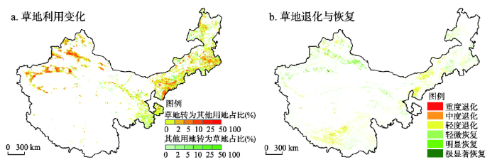
2000—2015年主要草原牧区草地面积净减少约163万hm2,其中草地转入约110万hm2,草地转出约273万hm2(表2、图1a)。其中,新疆净减少最多,约108万hm2。草地植被覆盖度总体呈现增加趋势,其中,温性草原类增加最多,每年约1.6%,而温性和高寒草甸类每年分别减少了1.0%、0.3%(表3)。甘肃、青海、内蒙古的草地植被覆盖度总体增加,而西藏和新疆减少。Tab. 2
表2
表22000—2015年中国主要草原牧区草地利用变化面积统计(hm2)
Tab. 2
| 区域 | 草地转入(其他类型转换为草地) | 草地转出(草地转换为其他类型) | ||||||||
|---|---|---|---|---|---|---|---|---|---|---|
| 森林 | 农田 | 湿地 | 荒漠 | 其他 | 森林 | 农田 | 湿地 | 荒漠 | 其他 | |
| 西藏 | 1216 | 66 | 323 | 181 | 0 | 267 | 780 | 61529 | 22640 | 4929 |
| 新疆 | 22143 | 56263 | 75557 | 70652 | 741 | 11544 | 1145914 | 73374 | 19090 | 54571 |
| 内蒙古 | 69309 | 173376 | 68247 | 366845 | 6307 | 181639 | 292424 | 63375 | 312295 | 184080 |
| 青海 | 2078 | 7702 | 1635 | 30443 | 214 | 563 | 14951 | 42912 | 84229 | 24563 |
| 甘肃 | 7579 | 89126 | 5638 | 40042 | 495 | 38003 | 62720 | 4768 | 13877 | 16394 |
| 合计 | 102325 | 326533 | 151400 | 508163 | 7757 | 232016 | 1516789 | 245958 | 452131 | 284537 |
新窗口打开|下载CSV
图1
 新窗口打开|下载原图ZIP|生成PPT
图1中国主要草原牧区草地利用变化、草地退化与恢复空间分布
Fig. 1Distributions of grassland use change and grassland degradation and restoration in China's pasture regions
Tab. 3
表3
表32000—2015年中国主要草原牧区草地植被覆盖度变化统计
Tab. 3
| 草地类型 | 合计 | 西藏 | 内蒙古 | ||||||
|---|---|---|---|---|---|---|---|---|---|
| 均值(%) | 均值变化(%) | 趋势(%/a) | 均值(%) | 均值变化(%) | 趋势(%/a) | 均值(%) | 均值变化(%) | 趋势(%/a) | |
| 高寒草原类 | 18.97 | 0.11 | 0.01 | 15.38 | -0.21 | -0.06 | 14.69 | 0.35 | 0.11 |
| 高寒草甸类 | 53.35 | -0.32 | -0.06 | 45.86 | -0.58 | -0.13 | 53.27 | 1.74 | 0.35 |
| 高寒荒漠类 | 7.68 | 0.34 | 0.06 | 6.34 | 0.29 | 0.05 | - | - | - |
| 温性草原类 | 43.62 | 1.59 | 0.28 | 36.78 | -1.16 | -0.24 | 45.03 | 2.13 | 0.36 |
| 温性草甸类 | 75.88 | -0.99 | -0.19 | 67.58 | -1.31 | -0.23 | 85.27 | 0.54 | 0.07 |
| 温性荒漠类 | 9.41 | 0.52 | 0.10 | 6.03 | -0.34 | -0.06 | 4.68 | 0.21 | 0.05 |
| 草地合计 | 9.40 | 0.53 | 0.10 | 28.50 | -0.37 | -0.09 | 29.41 | 1.33 | 0.23 |
| 草地类型 | 新疆 | 甘肃 | 青海 | ||||||
| 均值(%) | 均值变化(%) | 趋势(%/a) | 均值(%) | 均值变化(%) | 趋势(%/a) | 均值(%) | 均值变化(%) | 趋势(%/a) | |
| 高寒草原类 | 25.77 | -0.09 | -0.04 | 17.05 | 1.19 | 0.24 | 29.45 | 1.14 | 0.24 |
| 高寒草甸类 | 51.60 | -0.76 | -0.17 | 75.32 | -0.05 | 0 | 59.85 | 0.13 | 0.01 |
| 高寒荒漠类 | 5.41 | 0.38 | 0.07 | 16.67 | 0.93 | 0.2 | 16.75 | 0.49 | 0.10 |
| 温性草原类 | 43.71 | -1.19 | -0.22 | 40.94 | 3.34 | 0.67 | 37.48 | 2.03 | 0.42 |
| 温性草甸类 | 76.41 | -2.82 | -0.55 | 80.17 | 0.77 | 0.15 | 65.60 | 0.66 | 0.16 |
| 温性荒漠类 | 13.70 | 0.67 | 0.13 | 7.29 | 0.75 | 0.13 | 9.58 | 0.77 | 0.16 |
| 草地合计 | 28.17 | -0.11 | -0.02 | 35.07 | 1.19 | 0.23 | 35.07 | 1.19 | 0.23 |
新窗口打开|下载CSV
草地退化面积约占主要草原牧区草地面积的6.7%,以轻度退化为主(表4),主要为内蒙古中东部的温性草原类、青藏高原东南部的高寒草甸类(图1b)。草地恢复约占5.4%,以轻微恢复为主,主要为天山南北的温性草原类和温性荒漠类。从省域来看,内蒙古的草地退化占比最高,而新疆的草地恢复占比最高。
Tab. 4
表4
表4中国主要草原牧区草地退化与恢复类型及面积统计
Tab. 4
| 草地退化/ 恢复类型 | 合计 | 西藏 | 内蒙古 | 新疆 | 甘肃 | 青海 | ||||||
|---|---|---|---|---|---|---|---|---|---|---|---|---|
| 面积(hm2) | 比例(%) | 面积(hm2) | 比例(%) | 面积(hm2) | 比例(%) | 面积(hm2) | 比例(%) | 面积(hm2) | 比例(%) | 面积(hm2) | 比例(%) | |
| 重度退化 | 44400 | 0.02 | 30200 | 0.03 | 4700 | 0.01 | 7100 | 0.01 | 0 | 0.00 | 2400 | 0.01 |
| 中度退化 | 582000 | 0.21 | 331500 | 0.38 | 145400 | 0.18 | 70300 | 0.14 | 9400 | 0.05 | 25400 | 0.07 |
| 轻度退化 | 17709300 | 6.51 | 6751400 | 7.65 | 6602300 | 8.38 | 2599400 | 5.07 | 542600 | 3.14 | 1210100 | 3.32 |
| 退化合计 | 18335700 | 6.74 | 7113100 | 8.06 | 6752400 | 8.57 | 2676800 | 5.22 | 552000 | 3.19 | 1237900 | 3.40 |
| 轻微恢复 | 11927000 | 4.38 | 1562500 | 1.77 | 3278400 | 4.16 | 5324500 | 10.38 | 1182900 | 6.84 | 574800 | 1.58 |
| 明显恢复 | 2147100 | 0.79 | 326600 | 0.37 | 208000 | 0.26 | 1411800 | 2.75 | 159500 | 0.92 | 40400 | 0.11 |
| 极显著恢复 | 487900 | 0.18 | 62900 | 0.07 | 17000 | 0.02 | 386900 | 0.75 | 13800 | 0.08 | 7200 | 0.02 |
| 恢复合计 | 14562000 | 5.35 | 1952000 | 2.21 | 3503400 | 4.45 | 7123200 | 13.89 | 1356200 | 7.84 | 622400 | 1.71 |
新窗口打开|下载CSV
3.2 草地牧草供给与草畜平衡演化特征
2000—2015年,主要草原牧区天然草地多年平均牧草供给量约334 kg/hm2,其中高寒草甸类最高,约500 kg/hm2,温性荒漠类最低,约148 kg/hm2(表5)。青海牧草供给量最高,约460 kg/hm2,其中高寒草甸类约577 kg/hm2。新疆最低,约239 kg/hm2,其中天山、阿尔泰山的温性草甸类约354 kg/hm2(图2a)。天然草地牧草供给量年增加约3 kg/hm2,其中温性草原类、温性草甸类、高寒草原类年增4.3 kg/hm2、3.7 kg/hm2和3.3 kg/hm2,而天山山脉、拉萨河流域则有所减少(图2b)。内蒙古农牧交错带、新疆西部、甘肃和青海东部的县域实际载畜量最高,超过10个羊单位/hm2,而青藏高原中部、内蒙古西部,则低于1个羊单位/hm2(图3a)。草地实际载畜量以增加为主(图3b)。Tab. 5
表5
表52000—2015年中国主要草原牧区不同类型天然草地牧草供给统计
Tab. 5
| 草地类型 | 全研究区 | 西藏 | 内蒙古 | 新疆 | 甘肃 | 青海 | |||||||||||
|---|---|---|---|---|---|---|---|---|---|---|---|---|---|---|---|---|---|
| 均值(kg/hm2) | 趋势(kg/hm2·a) | 均值(kg/hm2) | 趋势(kg/hm2·a) | 均值(kg/hm2) | 趋势(kg/hm2·a) | 均值(kg/hm2) | 趋势(kg/hm2·a) | 均值(kg/hm2) | 趋势(kg/hm2·a) | 均值(kg/hm2) | 趋势(kg/hm2·a) | ||||||
| 高寒草原类 | 20.23 | 0.13 | 19.72 | 0.1 | 20.52 | 0.56 | 12.04 | -0.02 | 10.82 | 0.02 | 28.78 | 0.43 | |||||
| 高寒草甸类 | 49.98 | 0.33 | 44.04 | 0.17 | 48.19 | 0.79 | 25.41 | -0.23 | 78.97 | 0.71 | 57.69 | 0.57 | |||||
| 高寒荒漠类 | 15.79 | 0.13 | 16.07 | 0.2 | - | - | 9.41 | 0.11 | 13.22 | -0.18 | 22.29 | -0.24 | |||||
| 温性草原类 | 42.75 | 0.43 | 36.41 | -0.03 | 44.7 | 0.54 | 34.06 | -0.12 | 46.92 | 0.68 | 43.37 | 0.8 | |||||
| 温性草甸类 | 48.2 | 0.37 | 61.75 | 0.16 | 55.84 | 0.54 | 35.43 | 0.1 | 63.57 | 0.68 | 37.22 | 0.35 | |||||
| 温性荒漠类 | 14.8 | 0.15 | 11.33 | 0.07 | 12.38 | 0.14 | 17.24 | 0.14 | 12.93 | 0.15 | 16.8 | 0.22 | |||||
| 草地合计 | 33.38 | 0.27 | 28.37 | 0.13 | 37.62 | 0.43 | 23.89 | 0.04 | 38.13 | 0.44 | 45.99 | 0.5 | |||||
新窗口打开|下载CSV
图2
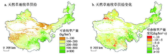 新窗口打开|下载原图ZIP|生成PPT
图22000—2015年中国主要草原牧区天然草地牧草供给多年平均与年际变化趋势
Fig. 2Distributions of annual average and variation trends of grassland forage supply in China's pasture regions in 2000-2015
图3
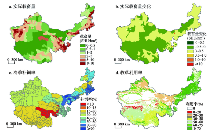 新窗口打开|下载原图ZIP|生成PPT
图3中国主要草原牧区草畜平衡状态评估输入参数
Fig. 3The input parameters for the assessment of forage-livestock balance in China's pasture regions
仅考虑天然草地牧草供给(图4a),载畜压力指数平均约3.8,内蒙古西部、河西走廊、新疆准噶尔盆地和塔里木盆地周边等区域的天然草地载畜压力多处于极度超载状态,而内蒙古东北部、青藏高原中部的草地则仍有载畜潜力。实际冷季补饲情况下(图4b),载畜压力指数平均约3.1,天然草地载畜压力在内蒙古中东部由于较高的补饲率而明显缓解,而在其他区域因补饲率低而变化不大。假设冷季全额补饲情景下(图4c),载畜压力指数平均约1.9,内蒙古、青藏高原等大部分天然草地将转变为载畜不足状态,但中、重度超载区由于暖季载畜压力因而难以缓解。2000—2015年天然草地载畜压力持续增加,仅锡林郭勒等地载畜压力有所缓解(图4d)。
图4
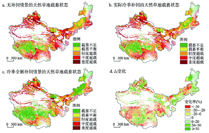 新窗口打开|下载原图ZIP|生成PPT
图42000—2015年主要草原牧区天然草地载畜压力状态及其指数变化
Fig. 4Patterns and trends in livestock-carrying pressure on natural grasslands in China's pasture regions in 2000-2015
3.3 草地生态系统保护与修复格局
叠加分析过去16年草地利用变化、退化与恢复状况、牧草供给状况,并评估不同情景下的天然草地草畜平衡状态,基于草地生态保护与畜牧业可持续发展的平衡原则,解析草原牧区不同模式的草地生态保护与恢复格局(图5)。图5
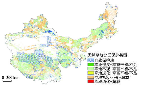 新窗口打开|下载原图ZIP|生成PPT
图5草地生态系统保护与修复空间分布格局
Fig. 5Spatial patterns of grassland conservation and restoration
(1)自然保护地、生态脆弱区、江河源头关键生态功能区、高寒荒漠区等需要实行严格的天然草地保护制度。对于局部由于人为因素造成的天然草场退化,可通过封育、禁牧等自然恢复措施加以改善,禁止发展人工草地。
(2)处于退化且超载的天然草地需实施休牧和草地修复。以阴山、鄂尔多斯高原、拉萨河流域为典型,通过休牧恢复天然草地生产力,不破坏原始植被并利用近自然草种补播促使草原植被复壮,减少毒杂草风险。在水热条件好的区域推广人工草地建设,加强区域间饲草资源调配以扩大饲草来源,推广异地育肥,实现休牧不休养、减畜不减产。
(3)牧区处于退化或不变但载畜平衡甚至不足的天然草地需实施划区轮牧和草地改良。通过轮牧和草地改良促进天然草地恢复,在保护天然草地同时,科学地界定区划人工草地开发建设的适宜与不适宜发展区域,改良和提升人工草地种植技术,推广放牧型人工草地、减少刈割型草地。
(4)农区和半农半牧区处于退化但仍超载的天然草地以改良为主。通过产业结构调整大力发展特色高效草牧业,利用草田轮作、粮改饲等提高补饲饲草种类和产量,改进人工草地播种方式、水肥管理方式、刈割或采食的时间、频度和总量等,实现可持续高产种植。加快现代牧业产业化、规模化、集约化程度,从而大幅度提高畜牧生产效率和经济效益。
(5)其他处于恢复且载畜平衡甚至不足的天然草地严格实行以草定畜。以天山东段、锡林郭勒为典型,需要精确监测牧草产量和牲畜数量的年内季节甚至月动态变化,借鉴农区畜牧业与短期育肥生产体系,逐步增加冷季精料补饲量,从而达到精细地以草定畜、保持草地好转态势的目标。
4 讨论与结论
4.1 讨论
本文得到的主要草原区天然草地实际超载状态与内蒙古、青海和西藏已有研究结果基本一致[25-26, 50],并且得到了1 km栅格尺度的草地载畜状况分布。本文的不确定性在于:① 基于植被覆盖度变化得到草地退化与恢复,难以检测出毒杂草和黑土滩等草地土壤退化信息;② 以县域家畜数量平均分配到1 km栅格草地上,未能体现县域内部实际载畜量空间差异;③ 家畜出栏率、草地放牧时间、牧草利用率、可食牧草比例等参数较粗,或按区域平均,或按草地类型赋值,有待更精细的参数本地化;④ 从牧户、县域到省域的补饲量在不同年份皆有差异,本文根据各区域冷季可食饲草储量估算补饲率,未考虑饲草料贸易流动;⑤ 年内的牧草供给与草畜平衡状态皆是动态变化量,以“冷季、暖季”划分,未考虑月动态,可能难以有效解决牧区普遍存在的季节性超载问题[51,52];⑥ 仅考虑家畜,未考虑三江源、羌塘、阿勒泰、阿尔金、塔什库尔干等保护地出现藏野驴、藏羚羊、野牦牛等野生食草动物种群数量扩大,与家畜争食、过度采食以致草地退化现象[40,41]。以干旱半干旱气候为主的草原牧区的草地生产力、牧草供给量与降水量相关性最高[19,20,21]。放牧通过选择性的采食、践踏影响草地,地上和地下生物量均随放牧强度的增加而下降[24]。反之,退牧还草、退耕还草以及草原三牧(休牧、轮牧、禁牧)等措施使局部草地得到恢复。针对草地退化与恢复及其载畜压力时空差异,本文分区提炼了草地生态保护与生产利用的不同模式,即以保护和恢复植被为核心,以转变经济发展方式为主线,大力发展“减压增效”可持续生态畜牧业,以草畜平衡为核心,通过牧草供给信息的精确获取,实现畜群调整、精准放牧,实现生态养畜的信息化和智能化。着力促进生态保护、民生改善和区域经济协调发展,由以治标为主的应急抢救型向标本兼治的长效机制型转变,实现生态保护治理与经济可持续发展同步协调推进。
4.2 结论
本文分析了2000—2015年中国草原牧区草地退化与恢复状况以及牧草供给、草地载畜压力的时空变化,并对草地生态保护与生产利用提出针对性策略。结果表明,主要草原牧区草地面积净减少,而单位面积天然草地牧草供给普遍增加,载畜压力亦持续增加。3种草畜平衡状态情景对比发现,补饲可缓解内蒙古中东部等区域的天然草地载畜压力,但由于其他区域补饲率低,因此缓解效果不明显,假设冷季全额补饲则载畜压力指数可减半。通过分析草地退化/恢复、草畜平衡状态,本研究针对自然保护地、牧区、半农半牧区和农区等区域提出了差异化的草地生态保护和生产利用策略。参考文献 原文顺序
文献年度倒序
文中引用次数倒序
被引期刊影响因子
[本文引用: 2]
[本文引用: 2]
[本文引用: 1]
[本文引用: 1]
DOI:10.11849/zrzyxb.2011.08.010URL [本文引用: 2]

In this paper, the typical desert grassland in Northern Tianshan Mountains was studied for analyzing pattern dynamic changes of desert grassland between 1990 and 2008 by means of point-line-surface methods. Human activity areas (city and agriculture) of typical grassland were used as study sites for discussing dynamic changes according to landscape ecologic method. In addition, the causes for grassland degradation were discussed from natural factors to social factors. The result showed that the areas of grassland decreased and those of agricultural and other land use types increased during the last 19 years. At the same time, grassland vegetation coverage also declined from 1990 to 2008, especially middle and high coverage grassland vegetation. In order to gain a clear cause of grassland changes, natural and social factors were discussed. The main factors of grassland area decreased and grassland degradation was caused due to human activities and unreasonable use of grassland resource. Therefore, these results implied that grassland resource reasonable and scientific utilization was the theoretical basis for grassland sustainable development.
[本文引用: 2]
DOI:10.11821/xb200804001URL [本文引用: 2]
Using MSS images in the middle and late 1970s, TM images in the early 1990s and TM/ETM images in 2004, grassland degradation in the Three-River Headwaters Region is interpreted through analysis on RS images in two time series, then the spatial and temporal characteristics of grassland degradation since the 1970s in the Three-River Headwaters Region are analyzed. The results show that grassland degradation in the Three-River Headwaters Region is a continuous changing process which has large area of influence and long time scale, and the drastic intensification phenomenon does not exist in the 1990s as a whole. Grassland degradation pattern in the Three-River Headwaters Region took shape initially in the middle and late 1970s, since the 1970s, this degradation process has taken place continuously, characterizing obviously different rules in different regions. Such as, in humid and sub-humid meadow grassland, grassland firstly fragmentizes, then the degree of vegetation coverage decreases continuously, and finally "black-soil-patch" degraded grassland formed. But in semiarid and arid steppe regions, the degree of grassland vegetation coverage decreases continuously, and finally desertification formed. Because grassland degradation has obvious regional diversity, grassland degradation in the Three-River Headwaters Region could be classified into seven regions, and each region has different characteristics in type, grade, scale and time process of grassland degradation.
[本文引用: 2]
[本文引用: 3]
[本文引用: 3]
[本文引用: 1]
[本文引用: 1]
[本文引用: 1]
[本文引用: 1]
[本文引用: 1]
[本文引用: 1]
[本文引用: 1]
[本文引用: 1]
[本文引用: 1]
[本文引用: 1]
[本文引用: 1]
[本文引用: 1]
[本文引用: 1]
[本文引用: 1]
[本文引用: 1]
[本文引用: 1]
[本文引用: 1]
[本文引用: 1]
DOI:10.5846/stxbURL [本文引用: 1]
[本文引用: 1]
[本文引用: 1]
[本文引用: 1]
[本文引用: 1]
DOI:10.1016/j.jenvman.2012.12.040URLPMID:23391757 [本文引用: 2]
We explored the ecological effects of grassland restoration programs using satellite imagery and field plots sampling data and analyzing the patterns and mechanisms of land cover change and vegetation activities in arid and semiarid China during the period from 1982 to 2008. The grassland cover in the 1980s, 2000 and 2005 was compared before and after the restoration programs. The variability of net primary production (NPP) and rain use efficiency (RUE) were analyzed as indicators of vegetation productivity. Our study showed that changes in grassland cover were closely related to the relative area of farmland, with increases in grassland being caused by returning farmland to grassland and decreases being caused by reclamation for agriculture. The results of NPP and RUE measurements over the past 30 years showed systematic increases in the area of grassland in most regions, especially from 2000 to 2008. This fact was reflected by intensified vegetation activity and cannot be completely explained by the warmer and wetter climate, which suggested a contribution from restored, ungrazed grasslands. Our analysis indicates that both vegetation activity and grassland cover increased in regions in which grassland and rangeland restoration programs were implemented.
[本文引用: 2]
[本文引用: 2]
DOI:10.1890/07-0992.1URLPMID:18724724 [本文引用: 2]
Understanding how the aboveground net primary production (ANPP) of arid and semiarid ecosystems of the world responds to variations in precipitation is crucial for assessing the impacts of climate change on terrestrial ecosystems. Rain-use efficiency (RUE) is an important measure for acquiring this understanding. However, little is known about the response pattern of RUE for the largest contiguous natural grassland region of the world, the Eurasian Steppe. Here we investigated the spatial and temporal patterns of ANPP and RUE and their key driving factors based on a long-term data set from 21 natural arid and semiarid ecosystem sites across the Inner Mongolia steppe region in northern China. Our results showed that, with increasing mean annual precipitation (MAP), (1) ANPP increased while the interannual variability of ANPP declined, (2) plant species richness increased and the relative abundance of key functional groups shifted predictably, and (3) RUE increased in space across different ecosystems but decreased with increasing annual precipitation within a given ecosystem. These results clearly indicate that the patterns of both ANPP and RUE are scale dependent, and the seemingly conflicting patterns of RUE in space vs. time suggest distinctive underlying mechanisms, involving interactions among precipitation, soil N, and biotic factors. Also, while our results supported the existence of a common maximum RUE, they also indicated that its value could be substantially increased by altering resource availability, such as adding nitrogen. Our findings have important implications for understanding and predicting ecological impacts of global climate change and for management practices in arid and semiarid ecosystems in the Inner Mongolia steppe region and beyond.
[本文引用: 2]
[本文引用: 3]
[本文引用: 3]
[本文引用: 1]
[本文引用: 4]
[本文引用: 4]
DOI:10.11849/zrzyxb.2007.03.008URL [本文引用: 4]
[本文引用: 4]
[本文引用: 3]
[本文引用: 3]
[本文引用: 1]
[本文引用: 1]
[本文引用: 2]
[本文引用: 2]
[本文引用: 1]
[本文引用: 1]
[本文引用: 2]
[本文引用: 2]
[本文引用: 3]
[本文引用: 3]
[本文引用: 1]
[本文引用: 1]
[本文引用: 2]
[本文引用: 2]
[本文引用: 2]
[本文引用: 2]
[本文引用: 1]
[本文引用: 1]
[本文引用: 4]
[本文引用: 4]
[本文引用: 1]
[本文引用: 1]
URL [本文引用: 1]
In recent decades, the ecological environment of grassland in Ali of Tibet has degraded continuously, which has attracted attention of local governments at different levels. Therefore, it is urgent to probe into the causes and improvement techniques of the degradation. In this paper, the overview and types of grassland resources and grazing capacity in Ali of Tibet were discussed. The results showed that the theoretical grazing capacity of Ali region was 2.993 7 million standard sheep and the actual grazing capacity is 3.466 6 million in 2010. Compared with the theoretical grazing capacity, the actual grazing capacity overloaded 15.80%. Based on the grassland resources and grazing capacity, it is suggested that the best suitable measures for local conditions should be taken, such as arranging grazing rationally and utilizing grassland resources scientifically to promote the sustainable development of animal husbandry.
[本文引用: 1]
[本文引用: 1]
[本文引用: 1]
[本文引用: 2]
[本文引用: 2]
[本文引用: 2]
[本文引用: 2]
DOI:10.11821/xb200506009URL [本文引用: 1]
o41' to 95o11'E and from 30o27' to 35o39'N, northern Tibet in the highest of Tibet is known as the ridge of the roof of world with a mean elevation of 4500 m. Northern Tibet is the headstream of the Yangtze River, Nujiang River and Lancang River. It is both the "sensitive area" of climate system and the "water tower" of China. The environmental condition of this area has significant effect on the main rivers, climate and eco-environment of Tibet and the whole country, even on the globe for its rigorous natural condition and fragile ecosystem. This study selected vegetation cover as the main evaluation index, calculated the grassland degradation index (GDI) and established the remote sense monitoring and evaluation system for grassland degradation in northern Tibet, according to the national standard (GB19377-2003), based on the remote sensing data such as NDVI data derived from NOAA/AVHRR with a spatial resolution of 8 km of 1981-2000 and from SPOT/VGT with a spatial resolution of 1 km of 2001 and from MODIS with a spatial resolution of 0.25 km of 2002-2004 respectively in this area, in combination with the actual condition of grassland degradation. The grassland degradation processes and their response to climate change during 1981-2004 were discussed and analyzed systematically in the study. The result indicated that grassland degradation in northern Tibet is very severe, and mean value of the GDI in recent 20 years is 2.54 which belongs to the severe degradation grade. From 1981 to 2004, the grassland degradation fluctuated evidently with great interannual variations in proportion of degradation degree and GDI but the total tendency turned to severe during this period with the grassland degradation grade changed from light to severe in northern Tibet. The extremely seriously degraded and seriously degraded respectively occupied 1.7% and 8.0% of the study area, the moderately and lightly degraded grassland accounted for 13.2% and 27.9% respectively and un-degraded grassland occupied 49.2% of the total grassland area in 2004. The grassland degradation was severe especially in the conjunctive area of Naqu, Biru and Jiali counties, the headstream of the Yangtze River that is Galadandong snow mountain, the areas along the Qinghai-Tibet railway and highway, and areas around the Tanggula and Nyainqentanglha snow mountains and glaciers. So the snow mountains and glaciers as well as their adjacent areas in northern Tibet which were sensitive to climate change and the areas along the vital communication line with frequent human activities experienced relatively severe grassland degradation.]]>
[本文引用: 1]
DOI:10.3724/SP.J.1047.2011.00549URL [本文引用: 1]
[本文引用: 1]
DOI:10.11821/dlxb201805001URL [本文引用: 1]
3 km2, while cropland decreased by 4.9×10³ km2, and the total area of woodland and grassland decreased by 16.4×10³ km2. The spatial pattern of land-use changes in China during 2010-2015 was concordant with that of the period 2000-2010. Specially, new characteristics of land-use changes emerged in different regions of China in 2010-2015. The built-up land in eastern China expanded continually, and the total area of cropland decreased, both at decreasing rates. The rates of built-up land expansion and cropland shrinkage were accelerated in central China. The rates of built-up land expansion and cropland growth increased in western China, while the decreasing rate of woodland and grassland accelerated. In northeastern China, built-up land expansion slowed down continually, and cropland area increased slightly accompanied by the conversions between paddy land and dry land. Besides, woodland and grassland area decreased in northeastern China. The characteristics of land-use changes in eastern China were essentially consistent with the spatial governance and control requirements of the optimal development zones and key development zones according to the Major Function-oriented Zones Planning implemented during the 12th Five-Year Plan (2011-2015). It was a serious challenge for the central government of China to effectively protect the reasonable layout of land use types dominated with the key ecological function zones and agricultural production zones in central and western China. Furthermore, the local governments should take effective measures to strengthen the management of territorial development in future.]]>
[本文引用: 1]
[本文引用: 2]
[本文引用: 2]
[本文引用: 1]
[本文引用: 1]
DOI:10.3969/j.issn.1001-7410.2014.04.09URL [本文引用: 1]
p<0.01) and R/S of montane meadow was significantly different from other grassland types(p<0.01). Temperate meadow steppe and temperate desert steppe had relatively higher R/S the means of which were 7.0 and 6.8 respectively. There were evidence of positive effects of mean annual precipitation on AGB and BGB and negative effects on R/S. The effects of mean annual temperature on AGB BGB and R/S were different with that of mean annual precipitation. Although mean annual temperature had the positive effects on AGB the effects on BGB and R/S were not significant. In order the better to analyze how to estimate BGB based on AGB the paper explored the relationship between above-and below-ground biomass. The results showed that BGB was significantly positive correlated with AGB in alpine steppe(R2=0.67)>temperate desert steppe(R2=0.36)>alpine meadow(R2=0.13). The power function fitted well with the relationship between BGB and AGB for these three types of grassland. The relationship between above-and below-ground biomass was not found in other three types of grassland. It was evident that both R/S and the relationship between AGB and BGB must be considered together when BGB was estimated.]]>
[本文引用: 1]
[本文引用: 1]
[本文引用: 1]
URL [本文引用: 1]
[本文引用: 1]
URL [本文引用: 1]
[本文引用: 1]
DOI:10.1007/s10661-009-1258-1URL [本文引用: 1]
Inter-annual dynamics of grassland yield of the Three Rivers Headwaters Region of Qinghai–Tibet Plateau of China in 1988–2005 was analyzed using the GLO-PEM model, and the herbage supply function was evaluated. The results indicate that while grassland yield in the region showed marked inter-annual fluctuation there was a trend of increased yield over the 18 years of the study. This increase was especially marked for Alpine Desert and Alpine Steppe and in the west of the region. The inter-annual coefficient of variation of productivity increased from the east to the west of the region and from Marsh, Alpine Meadow, Alpine Steppe, Temperate Steppe to Alpine Desert grasslands. Climate change, particularly increased temperatures in the region during the study period, is suggested to be the main cause of increased grassland yield. However, reduced grazing pressure and changes to the seasonal pattern of grazing could also have influenced the grassland yield trend. These findings indicate the importance of understanding the function of the grassland ecosystems in the region and the effect of climate change on them especially in regard to their use to supply forage for animal production. Reduction of grazing pressure, especially during winter, is indicated to be critical for the restoration and sustainable use of grassland ecosystems in the region.
[本文引用: 1]
[本文引用: 1]
