 ,1,2, 张学珍1,2, 刘洋1, 郝志新,1,2
The assessment on hydroclimatic changes of different regions in China at multi-scale during the past millennium
ZHENG Jingyun,1,2, ZHANG Xuezhen1,2, LIU Yang1, HAO Zhixin,1,2通讯作者:
收稿日期:2019-06-14修回日期:2020-06-3网络出版日期:2020-07-25
| 基金资助: |
Received:2019-06-14Revised:2020-06-3Online:2020-07-25
| Fund supported: |
作者简介 About authors
郑景云(1966-), 男, 研究员, 博士生导师, 主要从事气候变化研究。E-mail:

摘要
关键词:
Abstract
Keywords:
PDF (3810KB)元数据多维度评价相关文章导出EndNote|Ris|Bibtex收藏本文
本文引用格式
郑景云, 张学珍, 刘洋, 郝志新. 过去千年中国不同区域干湿的多尺度变化特征评估. 地理学报[J], 2020, 75(7): 1432-1450 doi:10.11821/dlxb202007008
ZHENG Jingyun, ZHANG Xuezhen, LIU Yang, HAO Zhixin.
1 引言
过去千年气候是当代与未来气候变化的背景,对理解气候系统年代至百年尺度的变化机理、预估增暖情景下的降水异常格局等有独特价值[1]。IPCC评估认为:随着全球增暖,北半球中纬度陆地降水的区域平均自1901年以来呈增加趋势(其中1951年之前为中等信度,之后为高等信度),且存在显著的区域差异。其中北美、欧洲、亚洲北部和中部等的大部地区降水增加;亚洲东部、南部和地中海周边等的大部分地区降水却在减少,且出现了程度更强、持续时间更长的干旱事件[2]。因而,揭示过去千年干湿的多尺度变化、辨识当代降水是否超出自然变率约束等成为了近年气候变化研究领域的“热点”问题,得到学界的空前关注。至今已重建了全球[3,4]、半球[5]、洲际[6,7,8,9,10,11]及多个区域[12,13,14]的干湿序列与数据集。中国地处北半球的东亚地区,境内地理环境复杂,季风、干旱、高寒气候并存,类型多样;有丰富、连续的历史气象记录,这些记录定年准确、气候意义明确;还有树轮、冰芯、石笋、湖泊沉积等多种自然代用证据,可用于相互补充和比对。利用历史气象记录、树轮等年分辨率代用证据,中国****重建约300个地点(区)的降水或旱涝等级序列[13, 15-17],并编制中国过去500 a旱涝图集[18],揭示了中国历朝气候的基本特征[19];同时,还利用石笋、冰芯、湖泊沉积等研究一些区域千年干湿长期变化的阶段性,特别是中世纪与小冰期间的干湿差异[20,21,22,23]。已有评估发现:在中国东中部,1000—1240年气候偏干;1240—1420年总体偏湿,但波动频繁,1420—1540年再度转干;1540—1690年又再度呈波动特征,但总体偏湿;1690—1900年相对偏湿。在中国西北,半干旱地区过去2000 a气候总体呈现出百年尺度的暖湿、冷干组合波动;而干旱区气候则呈暖干、冷湿组合波动;这些地区20世纪降水变幅仍处在其前的过去千年自然变率范围之内[24,25,26]。
近年,中国又在上述研究基础上,利用各种代用资料重建了干湿及降水变化结果,深入开展了过去千年各地的年至百年尺度干湿变化研究,为进一步评估20世纪全球增暖背景下中国降水与干湿变化是否超出自然变率约束这一关键问题,提供了重要的科学基础。为此,本文拟对近10 a中国在这一问题研究上所取得的新结果进行梳理分析和总结,以期为编制《中国气候与环境演变》科学报告、《第四次气候变化国家评估报告》及深入开展相关问题研究等提供参考。
图1为本文所引用的近10 a根据文献、树轮等代用证据重建的降水与干湿序列与指示干湿变化的湖沼沉积、石笋、冰芯等代用资料的空间分布。由于中国气候类型多样、干湿变化存在显著区域差异,且不同区域的代用资料类型及空间覆盖度也各不相同,因此本文在分析各地干湿的多尺度变化特征时,先将这些代用资料大致分为4个地域9个区,然后参照政府间气候变化专门委员会(IPCC)的评估思路[2],按区对各地代用资料所揭示的干湿多尺度变化特征及研究结果进行梳理总结和分析对比,以评估同一区域内不同研究者根据不同类型代用资料所揭示的年至百年尺度变化特征是否具有一致性,以及各区域的20世纪干湿变幅的历史地位。这些区域分别是:东中部季风区,包括华北、江淮和江南3个区;东北地区和北方半干旱区,包括东北及内蒙古东部、黄土高原2个区;西北干旱区,包括河西走廊、新疆中北部2个区;青藏高原,包括高原北部、高原南部及川滇山地2个区。需要说明的是,该分区旨在按区进行代用资料的梳理与对比,以分析总结千年代用资料所揭示的干湿变化多尺度特征,因而它并无严格的分区界线,且有些区(如华北地区和黄土高原)还存在部分交叉。同时为直观显示各区干湿变化,本文选用其中与同区其它地点相关系数均超过0.01显著性水平,且指示年或某个季节干湿(或降水)变化的最长代用指标序列作为该区代表性序列;当被选取的代用指标序列超过2条时,则先将各序列校准为采样地的年降水变化标准化值,然后计算其均值作为该区的干湿指数。
图1
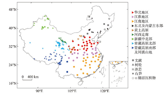 新窗口打开|下载原图ZIP|生成PPT
图1本文引用的降水与干湿代用资料分布
注:中心带点圆圈为用于集成重建北方过去2200 a降水变化序列其中的11个湖沼孢粉记录位置。
Fig. 1Map of cited proxies that used for reconstruction on hydroclimate in China
2 东中部季风区过去千年干湿变化
中国历史文献中丰富的水、旱灾害等记载为重建过去2000 a中国东中部(约40°N以南、105°E以东的陆域)季风区的干湿变化提供了独特资料。根据各地旱涝灾害强度、持续时间及影响大小等记载,先前研究已分别重建了1470年以来全国120个站[18]、过去2000 a东中部地区63个站[27]的逐年旱涝等级序列及近1000 a华北与长江下游6个区域(河北、山西、黄河下游、河南、江淮及苏杭)的干湿等级序列[28]。但由于受原始记载遗漏、失传与“记异不记常”“厚今薄古”及地区间社会经济文化发展不平衡、战乱等多个因素影响,使得这些旱涝等级数据均存在一定程度的缺值;且时间越早,缺值越多,覆盖区域亦越小。其中在760年之前主要集中在长江以北,特别是公元300年之前则更是只集中在华北与关中地区;长江以南地区记录较为稀少。不过,对比评估显示:这3套序列在共有时段所揭示的区域干湿变化特征高度一致,证明这些序列均可靠[24]。其中东中部地区63个站旱涝等级数据覆盖时段达过去2000 a,较其他2套序列更长,也较华北与长江下游6个区域的干湿等级序列覆盖区域更广[26]。根据过去2000 a东中部地区63个站的逐年旱涝等级序列,在利用多项式模拟各地记录数量变化趋势,剔除因历史记载遗失与“记异不记常”“厚今薄古”等因素而致的记录时空分布显著不均对区域干湿变化重建结果影响基础上,新近研究不仅将先前重建的中国东中部及华北、江淮和江南地区的干湿变化序列[29]延展至整个2000 a[30];同时还根据实有记录数量,以50 a为单位时段评估了重建结果的可信度(图2)。对各区干湿序列的分析显示:过去2000 a中国东中部干湿变化不但年际变率大,且存在显著的年代至百年际波动(图2a);其中各区干湿的年代至百年际波动主要特征如下。
图2
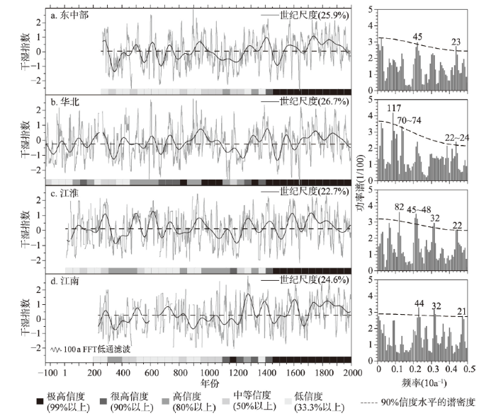 新窗口打开|下载原图ZIP|生成PPT
图2中国东中部、华北、江淮和江南地区过去2000 a干湿指数序列(左列)及其对应的功率谱(右列)
注:数据引自文献[30-31]。
Fig. 2The dry/wet index series (left) and power spectrum (right) for the past 2000 years in central-eastern China (a) and its sub-regions of North China Plain (b), Jiang-Huai Area (b), and Jiangnan Area(d)
(1)华北地区:华北地区干湿在公元前130年前后至公元210年间,以显著的多年代波动为主要特征,但总体相对偏干。210—280年前后,显著偏湿;此后在年代际波动中快速转干,并维持总体偏干至410年前后。410—440年前后,显著转湿。445—900年前后,又呈现显著的多年代波动特征,且总体也相对偏干。900—1000年,华北干湿虽仍呈明显的年代际波动,但总体显著偏湿。1000—1140年则在波动中持续逐渐趋干,此后虽在1180年前后出现短暂转湿,但后又持续偏干,直至1280年前后。1280—1400年,显著偏湿;仅1360年及1370年前后相对偏干。1410年前后起,又在波动中持续趋干至1500年前后;此后虽在波动中转湿,且1540—1570年也相对偏湿;但1570年起又再次在波动中转干,至明末(1627—1643年)出现了过去2000 a中最为严重的持续性干旱[32]。1645—1900年,华北气候总体偏湿,但年代际波动显著,其中1720年、1785年及1875年前后偏干。20世纪则又在波动中呈现总体偏干特征,仅1910年前后和1950年前后相对偏湿;特别是自20世纪70年代初起,又再次出现持续转干(图2b)。
(2)江淮地区:江淮干湿在公元初至220年前后,以年代际波动为主要特征。220—300年前后,在波动中转湿;但其后出现快速转干,310—480年前后,总体显著偏干。480—900年前后,主要呈年代和百年尺度波动,其中500年、600年和720年前后偏湿,550年、660年和800年前后偏干。900—1000年前后,总体偏湿,不过其中940年前后却显著偏干。1000—1210年前后,在年代际波动中逐渐趋干。此后至1650年前后又以年代和百年尺度波动为主要特征,其中1270年、1410年、1460年、1560年前后偏湿,1350年、1500年和1640年显著偏干。1650—1910年前后,虽总体偏湿,但1730年以后则在年代至百年尺度波动中逐渐趋干,其中1700年、1730年、1755年、1825年、1845年、1905年前后偏湿;1720年、1780年、1810年、1860年、1875年偏干。1910—1950年,总体偏干,1950—1990年前后相对偏湿;不过1990年之后,则又出现转干(图2c)。
(3)江南地区:除900—1100年和1800—2000年外,其他时段江南地区的干湿年代至百年际波动过程与江淮地区基本相似(图2d)。其中900—1100年江淮地区在年代际波动中逐渐趋干,而江南地区则在相对偏干的水平上呈显著的年代和多年代尺度波动。1800—2000年江南地区在相对偏湿的水平呈频繁的年代和多年代尺度波动,但江淮地区则存在总体趋干特征;且二者的波动位相也出现了错位。
对各区重建结果的可信度评估显示(图2):上述这3个地区的重建序列只有在公元1400年以后才达高(80%以上)、很高(90%以上)或极高信度(99%以上);而公元1400年之前,除华北有2/3的时段达高及以上信度外,江淮和江南地区分别只有38%和25%的时段具有高及以上信度,其他时段为中等(50%以上)或低信度(33.3%以上);特别是公元500年之前,江淮和江南地区分别有45%和60%的时段为低信度。但即便如此,仍可证明:各区20世纪的干湿变幅未超出其前千年时段的变率范围。
对华北、江淮和江南地区公元500年以来(即多数时段重建结果达中等及以上信度)干湿序列的周期分析与对比发现:在年代—百年尺度上,3个地区除均存在准22 a显著周期外;华北地区还有准70 a及准120 a周期;江淮地区还有准32 a、准45 a和准80 a周期;江南地区也还有准32 a和准44 a周期(均超过90%信度水平)。在年际尺度上,显著周期主要是准2.5 a和3.5~7.0 a(90%信度水平)[31]。年代以上尺度的滤波分析表明:在20~35 a尺度上,华北地区的周期性变率较江淮和江南地区更显著,其方差解释量达29.3%;而江淮和江南则均仅为22.6%。反之,在35~50 a尺度上,江淮和江南的周期性变率则较华北地区更强,其方差解释量分别达17.2%和18.8%;而华北则仅有12.3%。50~85 a尺度则以华北和江淮地区的变率更显著,其方差解释量分别达13.5%和12.1%;而江南地区则仅为7.5%。在世纪以上尺度,各区干湿变率的方差解释量分别为26.7%(华北)、22.7%(江淮)和24.6%(江南)。不过这些周期信号的强弱并不稳定,如在20~35 a尺度上,华北地区在20世纪的信号就显著偏弱,江淮流域在1850年之后也较弱;而50~85 a的准周期则在1800年之后显著增强[31]。
诊断还显示:上述这种多尺度变化特征与气候系统大尺度环流内部变率模态的强弱变化有关。其中在年际尺度上,在发生厄尔尼诺事件的当年与次年,华北地区有73%的年份降水偏少,长江流域则多数年份梅雨显著偏多[33]。而在年代际尺度上,随着1800年以后太平洋年代际振荡(Pacific Decadal Oscillation, PDO)的变幅增大,当PDO处于暖位相时,华北和华南地区往往偏干,江淮流域偏湿;冷位相时则相反,且其对江南地区的影响也相对减弱[31]。
3 东北地区和北方半干旱区过去千年干湿变化
该区域包括东北、内蒙古东部和黄土高原,其中东北主要为湿润、半湿润气候,内蒙古东部和黄土高原主要为半干旱气候;指示气候变化的代用证据主要来源于树轮、湖沼沉积物及黄土高原南侧的石笋等。其中东北[34,35,36,37]及内蒙古东部[38,39,40,41]的树轮记录大多只有200 a左右。达千年以上的气候代用资料主要源于湖沼沉积物;而在黄土高原,树轮记录可达500 a左右[17],且其南侧还有近2000 a的石笋记录;因此,这里根据代用资料的来源,按东北及内蒙古东部和黄土高原两个区域分析。(1)东北及内蒙古东部:目前这一地区达千年以上的气候变化代用资料主要源于湖沼沉积物,且多数研究覆盖至全新世[42,43,44,45,46];但受时间分辨率所限,这些研究重在分析全新世中晚期的百年际至千年尺度的气候趋势变化[45,46],而较少关注年代际至百年尺度的干湿变化。不过,从纹层湖小龙湾(42°18′N, 126°21′E)沉积物的重建结果周期分析可以看出:这一地区的干湿变化存在87~89 a和205~212 a等百年尺度的显著周期(99%信度水平)[44];辽宁沈阳周边山地(41°11′N~42°02′N, 122°25′E~123°48′E)[34]、医巫闾山(41°33′N, 121°38′E)[35]及西北部山地(41°37′N, 121°42′E)[36]和内蒙古东部的呼伦贝尔(48°14′N~48°17′N, 119°18′E~119°25′E)[38]、浑善达克(43°06′N~43°30′N, 116°24′E~117°12′E)[39]、喀喇沁(41°52′N, 118°47′E)[40]等多个地点树轮重建的结果显示:这一地区的干湿变化还存在显著的准2.5 a、3.5~5.0 a、7~9 a、18~22 a、35~44 a周期(95%信度水平)。
然而对比显示,不同湖泊或不同指标所揭示的过去2000 a干湿变化特征并不一致。其中,根据三江平原申家店(46°35′N, 130°40′E)沼泽泥炭沉积中的脂类生物标志物重建的结果表明,公元前50年(2000 cal a BP)前后,气候冷湿;此后至450年(1500 cal a BP)气候转干;450—1550年(1500—400 cal a BP)气候冷湿;1550年(400 cal a BP)以来气候暖干;分析还发现其中1550年以来的暖干气候特征可能是人类活动对孢粉干扰的结果[46]。但源自呼伦湖(48°31′N~49°21′N, 117°02′E~117°42′E)沉积物中的孢粉记录却显示,公元前100年至950年(2050—1000 cal a BP),该地区的蒿属植物孢粉减少,针叶树种孢粉上升,针叶林显著扩展,表明当时气候转为冷干,这与同时期三江平原气候冷湿特征不一致;不过该研究也证明:自公元1000年以来,孢粉变化可能受到人类活动的显著影响[45]。而内蒙古东部的岱海(40°28′N, 112°32′E)和达里湖(48°31′N~49°21′N, 116°29′E~116°45′E)沉积记录则显示:自公元前1500年(3450 cal a BP)前后起至今,这两个湖的湖面在波动中总体呈缓慢萎缩趋势,水位逐渐下降;其中公元前1200—700年(3150—2650 cal a BP)、300—800年(1650—1150 cal a BP)和1400—1750年(550—200 cal a BP),湖面水位最低,表明这些时段该地区气候可能相对偏干[47]。这些不一致特征虽与干湿变化的局地差异有关,但也进一步说明,目前对这一地区过去2000 a干湿百年尺度变化特征的认识仍存在不确定性。
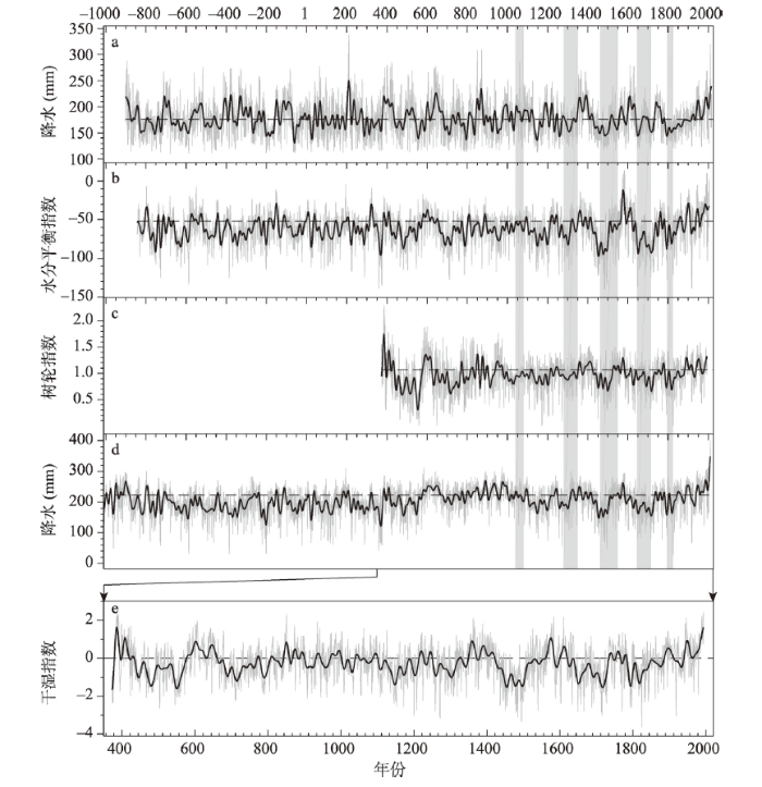
(2)黄土高原:这一地区利用树轮重建的干湿序列长者可达400 a以上,包括年降水量(上年8月—当年7月)或生长季降水及帕尔默干旱指数(Palmer Drought Severity Index, PDSI)等[48,49,50,51,52,53,54]。对比这些重建结果显示:不同地点之间的波动过程基本同步;其中大多数序列的周期分析结果显示:这一地区干湿变化存在显著的准2 a、3~5 a、20~23 a、40~50 a和80~120 a周期(90%信度水平)。且多数序列(图3a和图3b)及区域干湿指数(图3c)均显示:这一地区20世纪干湿存在大幅波动;其中20世纪20年代后期—30年代前期是过去400 a最干的年代之一,40—80年代相对偏湿,90年代相对偏干,至21世纪初则又出现转湿趋势。对比诊断分析还发现:这一地区干湿的年际和年代际变率分别与厄尔尼诺与南方涛动(El Ni?o-Southern Oscillation, ENSO)和PDO显著相关;ENSO和PDO位于暖位相时,这一地区的降水偏少,气候偏干[50, 54];这一关联特征也与华北地区干湿变化同ENSO和PDO的联系基本相似。
图3
 新窗口打开|下载原图ZIP|生成PPT
图3利用多种代用资料重建的过去千年东北和北方半干旱区干湿变化
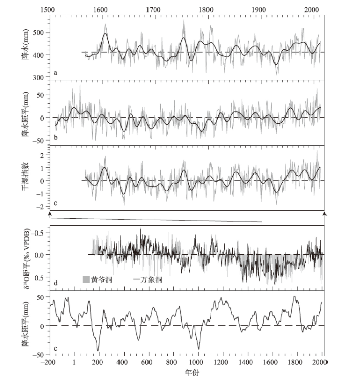
注:a为利用树轮重建的黄土高原西部年降水量(上年8 月—当年7 月)[50];b 为利用树轮重建的黄土高原东南部5 月降水量[54];c为根据a和b 两条序列标准化值计算的区域干湿指数;图a~图c粗实线表示10 a FFT低通滤波;d 为黄土高原南侧的万象洞与黄爷洞石笋δ18O记录[55-56];e为集成东北地区和北方半干旱区11 个湖沼沉积物(孢粉记录重建的该区域过去2200 a降水变化[57]);基准线表示1851—1950 年平均值。
Fig. 3Hydroclimate reconstructions based on multi-proxies in Northeast China and semi-arid region in North China
在更长的时间尺度上,位于黄土高原南侧的万象洞(33°19′N, 105°00′E)石笋δ18O记录(图3c)显示:190—530年,亚洲夏季风相对偏强;530—850年亚洲夏季风逐渐减弱,850—940年显著偏弱;此后则快速增强,960—1020年则显著偏强;而后在剧烈波动中逐渐趋弱,1340—1850年持续偏弱,其中1350—1380年和1580—1640年则显著偏弱;直至1850—1880年才再次快速转强;然后在较强水平上波动至2000年前后[55]。其邻近的黄爷洞(33°35′N, 105°07′E)石笋δ18O记录(图3d)也显示了类似的总体变化特征,并发现:301—320年、391—420年、601—630年、871—890年、1011—1050年、1131—1160年、1211—1240年、1351—1380年、1551—1580年和1621—1650年等时段曾出现剧烈的年代际转干。不过其中也有一些剧烈转干年代(如601—630年、1131—1160年等),二者的结果并不一致;这可能与定年的不确定性有关[56]。
此外,集成黄土高原至东北地区11个湖沼沉积物(具体位置参见图1)孢粉记录重建的该区域过去2200 a降水变化序列(图3e)显示,公元前200—100年、241—440年、561—840年、1101—1320年、1741—1820年和1921—2000年等6个时段偏湿;101—240年、441—560年、841—1100年、1321—1740年和1821—1920年等6个时段则偏干;同时还发生过8次显著的年代际大旱,分别出现在190年、510年、700年、1000年、1380年、1500年、1660年和1840年前后,且存在准23 a、57~67 a和准100 a的周期(达95%以上信度水平)[57]。但对比上述石笋记录表明,这些记录除揭示的一些重大干旱时段(如850—940年、1350—1380年和1580—1640年等)基本吻合外,其所反映的其他时段干湿变化特征却存在差异。这可能主要是因代用资料的不确定性(如定年误差及代用指标的气候指示意义等)而致。因为已有研究已证明:中国石笋的δ18O记录变化,很可能主要指示干湿气候格局的大尺度环流背景(即热带太平洋纬向海温梯度)变化,并不直接指示区域尺度的季风降水变化;而湖泊沉积代用指标也受多个气候环境要素变化的共同影响,且部分湖泊沉积中的近千年孢粉记录可能受到人类活动的显著干扰[42, 45];因而这些记录对区域降水变化的代表性尚需进一步确认[58]。
4 西北干旱区过去千年干湿变化
西北地区气候干旱,降水是树木径向生长的主要限制因素,因而树轮成为指示这一地区干湿变化的主要代用证据;已取得的资料主要分布在河西走廊和新疆中部的天山及北部的阿勒泰山,包括年或生长季的降水量与PDSI等[17];此外,新疆还有一些湖泊沉积记录可指示百年尺度的干湿变化。(1)河西走廊:河西走廊位于祁连山地北侧,祁连山北坡的圆柏树轮达千年以上;重建结果有:中段地区(约38°N~40°N, 99°E~101°E;775—2006年)的年降水量(图4a)[59]、东段(约37°~39°N, 100°~103°E;1009—2010年)和西段(约38°N~40°N, 96°E~99°E;1161—2010年)地区的生长季PDSI[60,61]及黑河中游地区(约38°N~41°N, 99°E~101°E;1430—2007年)径流量[62]。对比显示:河西走廊中段地区年降水和黑河中游地区径流量变化特征高度一致,且河西走廊东、中、西段和黑河中游等4个地区序列之间的两两相关均达0.05以上的显著性水平,波动特征基本一致。
图4
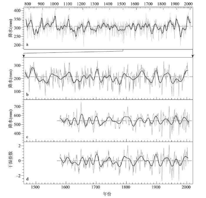 新窗口打开|下载原图ZIP|生成PPT
图4利用树轮重建的西北干旱区年降水变化
注:a为公元775—2006 年河西走廊中段地区的年降水量(上年8 月—当年7 月)[59];b 为公元1464—2005 年天山南部年降水量(上年7 月—当年6 月)[70];c为公元1580—2008 年天山中部年降水量(上年7月—当年6 月)[66];d 为根据图b 和图c两条序列标准化值计算的新疆中北部区域干湿指数;虚线表示1851—1950 年平均值;粗实线表示10 a FFT低通滤波。
Fig. 4Precipitation reconstructions based on tree rings in Northwest China
从最长的过去1200 a河西走廊中段地区年降水量(上年8月—当年7月)变化序列(图4a)看,这一地区的干湿变化存在显著的年际、年代际和百年尺度波动。对东、中、西各段重建结果的多窗谱分析也表明,这些序列均存在2~3 a、35~60 a和70~130 a的周期(90%信度水平),且20世纪的波动也并未超出其前的最大幅度[59,60,61]。不过略有差异的是在20世纪,河西走廊东、中段地区干湿在20世纪20年代以后随着年际和年代际波动持续转湿[59,60],而西段地区却无持续转湿趋势[61]。
(2)新疆中北部:新疆中北部也有多个利用树轮重建的降水量或PDSI序列,但大多不足300 a,仅利用天山中、西段和伊犁等地部分地点树轮重建的结果延展至300 a之前[63,64,65,66,67,68,69],其中最长的超过500 a[70]。对比分析表明:这些序列不但年代际尺度的波动过程在大多数时段一致,而且所指示的极端干旱年(低于序列均值2倍标准差的年份)多数也相同,仅位于北疆的阿尔泰山地和其他地区之间的一致性略差一些。对其中部分序列的周期分析表明:这一地区干湿年际和年代际变化的主周期分别为2~3 a和准60 a(95%信度水平),而准11 a、15~17 a和准30 a的周期信号则相对较弱;说明这一地区干湿变化可能主要受大气环流的准两年振荡和北大西洋涛动(North Atlantic Oscillation, NAO)影响[63, 69-70],同时也与太阳活动的准11 a周期变化有关;而受ENSO和PDO等的影响可能相对较弱。多个地点的降水重建结果均显示:这一地区整个20世纪与其前时段相比,总体并未偏干或偏湿,但年际和年代际波动特征极为显著,并发生了多次极端干旱(图4b、4c)。区域干湿指数序列显示:20世纪初相对偏湿;20世纪10年代起则显著转干;20—30年代相对转湿,但至40—50年代又转干;60年代偏湿,1970年偏干;1980—1990年则显著转湿;但21世纪初起似又出现转干特征(图4d)。
此外,对图4的河西走廊及新疆天山山地树轮重建的代表性降水序列相关分析显示:各序列间的两两相关系数均达0.05显著水平;且这些序列所揭示的显著干旱时段,如17世纪30年代、18世纪20—30年代、19世纪30—40年代和20世纪20年代前后等也高度一致,仅变幅和持续长度在区域间略有差异,这表明整个西北干旱区的年代际降水变化可能具有较好的一致性。
更长时间尺度上,来自北疆吉力湖(46°51′N~47°00′N, 87°20′E~87°32′E)的沉积记录[71]显示:过去2000 a中,公元前50年—650年,冷暖变幅大,但总体呈冷湿特征;650—1350年,总体暖干;1350—1850年,总体冷干;1850年以后又转为暖干。来自北疆阿勒泰山地铁外克湖(48°49′N, 87°00′E)过去900年的沉积记录显示:1090—1430年,气候温暖偏干;1430—1940年,气候寒冷偏湿;1940年以来又呈现暖干;其中1450年、1510年、1610年、1690年、1780年和1880年前后为6次显著的年代际多雨期[72]。二者对比表明15—19世纪为寒冷时期,但二者指示的干湿特征并不一致。11—14世纪和20世纪的“暖干”特征却大致对应,与先前指出的过去千年西北干旱区气候主要呈“暖干、冷湿”阶段配置总体特征[24]也基本相似,仅具体起讫时间约有100 a左右的差异;这可能主要是由于湖泊记录的定年不确定性(如测年误差、时间分辨率较低等)所致。
5 青藏高原过去千年干湿变化
指示青藏高原过去千年干湿变化有树轮、冰芯及湖泊沉积等多种代用资料。其中树轮资料采样点虽仅主要集中在高原东北部和南部[17],但因其采样密集,时间分辨率达年,且多数重建结果均具有较大区域的空间代表性,与利用冰芯、湖泊沉积等所指示的变化特征也具有一定可比性[73];因此,这里主要依据树轮重建的干湿变化结果进行总结。(1)青藏高原北部:青藏高原北部主要为干旱、半干旱气候,其中东北部是中国树轮研究的“热点”地区[17,74],现已重建了多条千年以上的降水或干湿变化序列。其中最长者为利用17个样点树轮重建的青藏高原东北部地区(约35oN~39oN, 96oE~101oE)年降水序列(上年7月—当年6月),达3500 a以上(公元前1500—2011年)[75]。其次是利用柴达木盆地东南部诺木洪山地(35°52′N~35°56′N, 96°30′E~96°35′E)8个样点树轮重建的年降水序列(上年7月—当年6月)达2917 a[76];且利用柴达木盆地东北部德令哈山地(37°09′N~37°32′N, 96°50′E~98°04′E)立木和古墓椁木树轮重建的1—6月水分平衡指数(指示生物干旱)序列达2847 a[77]。此外,用于指示柴达木盆地东部降水变化的都兰(约36°N~37°N, 98.0°E~98.5°E)树轮宽度指数序列也超过1600 a[78]。这些序列之间的年际变化高度相关,所指示年代际波动特征(特别是年代尺度的持续偏干及显著偏湿事件)和百年尺度的变化趋势基本一致[76](图5a~图5d);这不但证明这些重建结果具有高信度,而且也说明青藏东北部不同地点的干湿变化在过去数千年具有很好的一致性。对比这些树轮与位于青藏高原东部典型冰蚀湖希门错(33°23′N, 101°06′E)的沉积记录[79]也显示,在百年以上尺度,过去1000 a湖泊沉积物的总有机碳(TOC)、总氮(TN)等指标揭示的降水变化趋势也与这些序列的低频变化特征具有相似性,但二者给出的年代至多年代尺度波动特征存在一定差异,这可能与不同代用资料的定年精度和分辨率存在差异有关。综合这些序列空间代表性分析显示:这些序列可指示高原北部(唐古拉山以北)大部分地区(约33°N~39°N, 88°E~101°E)的干湿变化。
图5
 新窗口打开|下载原图ZIP|生成PPT
图5利用青藏高原北部树轮重建的各地过去3000 a干湿变化序列
注:a为诺木洪年(上年7月—当年6月)降水量[76];b为德令哈1—6月水分平衡指数[77];c为都兰树轮宽度指数[78];d为青藏高原东北部年(上年7 月—当年6 月)降水量[75];e为根据图a~图d 序列标准化值计算的区域干湿指数;浅灰色粗柱框为过去千年太阳黑子极小期;虚线表示1851—1950 年平均值;粗实线表示10 a FFT低通滤波。
Fig. 5Dry/wet changes in the north of Tibetan Plateau based on tree rings over the past 3000 years
分析显示:青藏高原东北部干湿在年际和年代际尺度上的波动周期分别为2~3 a、3.5~4.5 a、5~6 a、8~9 a和25~35 a及65~80 a(95%信度水平)[76,77],这与先前从一些覆盖时段较短的重建序列中所得到的结果一致[80,81,82]。此外,这些序列(图5)还存在显著的110~130 a和180~200 a百年际尺度周期波动(95%信度水平)[76,77]。根据这4个序列标准化值计算的区域干湿指数序列显示,这一地区的20世纪正处在一个自1800年前后开始的波动转湿过程中,是过去1600多年的最湿世纪之一(图5e)。这与高原北部的敦德(38°04′N, 96°14′E)、古里雅(35°14′N, 81°28′E)及中部的普若岗日(33°55′N, 89°07′E)等冰芯的冰川积累量记录自19世纪以来呈上升趋势的特征也基本一致[83,84],说明这一结果具有高信度。其中Yang等[75]重建的降水序列还显示,其最后10 a(2002—2011年)、25 a(1987—2011年)和50 a(1962—2011年)是过去3500 a同尺度的最湿时段(图5d),不过其他3个序列(图5a~图5c)和区域干湿指数序列(图5e),以及这一地区内覆盖时段相对较短的其他地点重建结果[81-82, 85-87]并不支持这一结果。这表明:尽管20世纪很可能是该地区过去3000 a最湿的世纪之一,但其年至百年尺度变幅也未超出其前时段的变率范围。
此外,对比诊断显示:这一地区干湿的年际尺度变率可能受印度洋偶极子(Indian Ocean Dipole, IOD)和ENSO影响,年代际尺度变率则可能受PDO和NAO共同影响[80,81,82]。特别是在过去千年5个太阳黑子极小期中,沃尔夫(Wolf Minimum, 约1280—1350年)、斯普雷尔(Sp?rer Minimum, 约1460—1550年)、蒙德尔(Maunder Minimum, 约1645—1715年)、道顿(Dalton Minimum, 1795—1823年)等4个极小期均对应这一地区的持续性干旱;奥尔特极小期(Oort Minimum, 约1010—1050年)也对应一个年代际的偏干事件[76-77, 80, 88];表明这一地区的干湿变化很可能还与太阳活动的阶段变化密切相关。
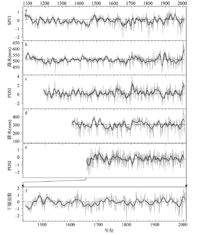
(2)青藏高原南部及川滇山区:位于唐古拉山以南的高原南部地形复杂,气候类型也较青藏高原东北部更为多样,主要有高原亚寒带半湿润气候(如那曲等地)和高原温带半干旱气候(如雅鲁藏布江上游及拉萨河流域等)、半湿润—湿润气候(如念青唐古拉山东段、喜马拉雅山东端和横断山等)等;至今也利用多个地点的树轮重建了干湿变化序列,重建指标有年和生长季前期(5—6月)的降水、标准化降水蒸散发指数(Standardized Precipitation Evapotranspiration Index, SPEI)和PDSI等[89,90,91,92,93,94,95];其中最长者达近1000年。对比这些重建结果(图6a~图6e)可以看出:虽然采样地点不同,重建指标各异,但多数序列所显示的年代际波动特征和显著干湿时段基本吻合。其中20世纪前、中期多在波动中略有趋干,而至20世纪80年代以后则在年际波动中快速转湿。根据这5个序列标准化值计算的区域干湿指数序列显示:这一地区的20世纪是过去600年来干湿变幅最显著的世纪之一,且在年代尺度上,20世纪30年代和2000年前后的10年与其前最湿的年代基本相当(图6f)。对比邻近的云南小白龙洞(24°12′N, 103°21′E)1760—1980年高分辨率石笋的δ18O记录[96]也发现,该石笋记录所揭示的1760—1850年和1900—1980年的转干趋势与这些树轮重建结果基本吻合,不过其间也存在不一致之处,如石笋δ18O记录显示19世纪50年代显著干旱,而树轮记录则显示其间相对偏湿。又对比位于青藏高原南部的达索普(28°23′N, 85°43′E)冰芯记录显示,冰川积累量在1750—1850年增加,1850年以来下降[83];而树轮记录则显示这一地区干湿主要呈年际和年代际波动。
图6
 新窗口打开|下载原图ZIP|生成PPT
图6利用青藏高原南部树轮重建的各地过去1000 a干湿变化序列
注:a为念青唐古拉山北部5—6 月SPEI[89];b为林周年降水量(上年7 月—当年6 月)[93];c为那曲东部5—6月PDSI[94];d 为雅鲁藏布江上游地区年降水量(上年7月—当年6 月)[91];e为横断山区年PDSI(上年5 月—当年4 月)[95];f 为图a~图e序列标准化值计算的区域干湿指数;虚线表示1851—1950 年平均值,粗实线表示10 a FFT低通滤波。
Fig. 6Dry/wet changes reconstructed from tree rings in the south of Tibetan Plateau over the past 1000 years
多窗谱分析显示,近千年高原中南部年降水变化存在显著的2~3 a周期(95%信度水平)和百年尺度波动[93],但年代际波动的周期信号不稳定。不过其东侧区域过去500年5—6月的PDSI变化序列显示,其间有显著的16~24 a波动[90];邻近的四川神奇洞(28°56′N, 103°06′E)过去2300年石笋δ18O记录也显示,这一地区降水变化有显著的准11 a、准22 a和准200 a周期(95%信度水平)[97];特别是高原东南端的横断山区年PDSI序列还检测出显著的3.4~5.5 a和准35 a、准60 a等多年代尺度周期波动(95%信度水平)[95];这与中国东中部干湿变化的周期性特征基本类似。对比诊断也显示,这一地区干湿的年际变化受热带太平洋地区海温异常引发的南亚夏季风变化显著影响[93, 95];而年代际变化则可能与PDO和NAO有关[95],不过其间联系机制极为复杂。
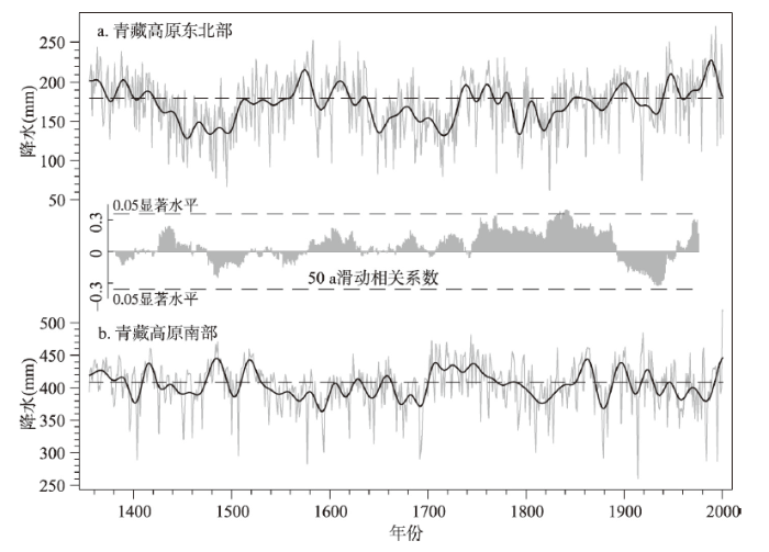
此外,还有研究利用青藏东北部9个和南部14个树轮年表资料,通过合成分别重建了代表高原南、北地区的过去500年5—6月PDSI序列,结果发现:高原南、北的5—6月干湿可能存在显著的多年代尺度反相变化,特别是其中的1463—1502年和1693—1734年,存在显著的“南湿北干”特征[87],类似发现后又得到利用树轮合成重建的过去600多年高原南、北5—7月PDSI序列的确认[98];且进一步发现,这可能是因NAO对高原南北降水的影响不同所致。然而,这种多年代尺度的干湿变化南北反相现象可能也只限于青藏高原主雨季来临之前的生长季前期(即5—6月),并未持续出现在所有时段,因为除1463—1502年、1693—1734年外,其他时段大多为同相或错位。此外,在过去600年,高原东北部和南部年降水(上年7月—当年6月)变化相关系数接近于零,50年滑动相关系数显示(图7)正相关(即同步变化)时段也占多数。
图7
 新窗口打开|下载原图ZIP|生成PPT
图7过去600 a青藏高原东北部和南部年(上年7月—当年6 月)降水变化对比及其50 a滑动相关系数
注:a为文献[75-76]降水重建结果的平均值;b 为文献[92-93]降水重建结果的平均值;基准线表示1851—1950 年平均值;粗实线表示10 a FFT低通滤波。
Fig. 7Comparison on the changes of precipitations from previous July to current June in the northeast (a) and south (b) of Tibetan Plateau, and the bar chart between (a) and (b) shows their correlation coefficient in the 50-year running windows
5 结论
利用历史文献、树轮、湖沼沉积、石笋、冰芯等代用资料,中国在过去10余年开展了大量的过去千年干湿变化研究工作。本文按区域对这些研究成果进行了总结梳理和对比分析,并评估了各个区域20世纪干湿变幅的历史地位,得到的主要结论如下:(1)在中国东中部季风区,对比评估表明根据历史文献记载重建的东中部各区干湿序列在公元1400年以后均达高信度,但其前存在记录缺失,仅有半数时段的重建结果达高信度;不过仍可证明:这一地区干湿变化存在显著的年际(准2.5 a和3.5~7.0 a)、年代际(准22 a、32 a、45 a)和百年际(70~80 a和准120 a)尺度周期。然而这些周期信号的强弱并不稳定,且可能与气候系统大尺度环流内部变率模态的强弱变化有关。在年际尺度上,发生厄尔尼诺事件的当年与次年,华北地区有73%的年份降水偏少,长江流域则多数年份梅雨显著偏多。在年代际尺度上,随着1800年以后PDO的变幅增大,当PDO处于暖位相时,华北和华南地区往往偏干,江淮流域偏湿;冷位相时则相反,且其对江南地区的影响也相对减弱。
(2)在东北及内蒙古东部地区,根据不同地点湖沼沉积物揭示的区域干湿百年尺度变化特征在多数时段不一致,表明对这一地区过去2000 a干湿百年尺度变化特征的认识仍存在不确定性;不过仍可发现,这一地区的干湿变化也存在准2.5 a、3.5~5.0 a、7~9 a、18~22 a、35~44 a、87~89 a和205~212 a等显著周期。
(3)在黄土高原、河西走廊和新疆中北部等半干旱、干旱地区,利用各区不同地点树轮重建的干湿变化序列,其所显示的干湿变化特征在区内一致性高,具有高信度。分析显示:这些地区的干湿变化均存在显著的2~3 a和准60 a周期;且其中黄土高原还与华北地区类似,也存在3~5 a、20~23 a和80~120 a的显著周期;但河西走廊和新疆中北部的3~5 a和20~23 a周期则不显著;说明黄土高原及周边地区干湿变化与ENSO和PDO等密切相关;而河西走廊和新疆地区干湿变化受ENSO与PDO的影响较弱。
(4)在青藏高原,利用东北部和南部各地树轮重建的干湿序列在区内变化特征基本一致,但冰芯、湖泊沉积及邻近石笋等记录的干湿变化特征仅部分时段与树轮结果吻合。利用树轮重建的干湿序列显示,这一地区干湿变化多存在2~3 a、3.5~4.5 a、25~35 a及65~80 a周期,其中高原东北部还存在显著的110~130 a和180~200 a等百年际尺度周期波动。此外,分析还发现:这一地区的年代际尺度波动可能受PDO和NAO的共同影响;且在百年尺度上,当太阳黑子活动处于极小期时,高原东北部多出现显著的持续性干旱;在年际尺度上,高原中南部地区的降水变化可能主要受印度洋偶极子IOD和ENSO影响。
(5)已有研究结果虽然显示,中国各地的干湿存在多个相同和相似的年际和年代际准周期,但对比显示,多数地区间的干湿变化位相并不同步。尽管从这些研究中已发现,青藏高原东北部20世纪很可能是过去3000年最湿的世纪之一;但大多数地区的重建结果均证明,20世纪的干湿变幅在年代际尺度上均未超出其前时段的变率范围。
然而,现有的对比分析评估也显示,即使是在同一区域内或邻近地点,源于湖泊沉积、石笋和不同类型代用记录(如树轮和石笋、冰芯等)所揭示的干湿变化特征尚存在不一致之处,如:东北及内蒙古东部、新疆北部等地区根据不同地点湖沼沉积物记录揭示的区域内干湿百年尺度变化特征,万象洞和黄爷洞石笋δ18O记录揭示的剧烈转干年代、以及这2个石笋δ18O记录与利用北方地区11个湖沼沉积物孢粉记录重建的干湿百年际变化,青藏高原树轮和冰芯指示的年代际干湿变化等,均在多个时段出现显著不一致现象。究其原因,虽可能与不同地点干湿变化的局地差异有关,但也说明利用这些代用证据重建干湿变化仍存在不确定性。特别是这些代用资料的测年误差、时间分辨率,代用指标响应干湿变化的时空敏感度及因此而致的时空代表性,以及湖沼沉积物、石笋、冰芯等代用证据的多数代用指标尚未与降水或干湿变化观测记录进行严格校准等,均可导致重建结果产生偏差,也导致无法对来自不同区域、不同地点、根据不同类型代用证据重建的不同尺度的降水/干湿重建变幅进行直接比较。此外,现有代用资料在空间覆盖度上也不均匀,如在东北、新疆南部、青藏高原西部以及云贵高原等几近空白,这些均需在下一步研究中予以加强。特别是需要进一步开展不同代用指标对降水、干湿变化的时空敏感度分析,进而分时空尺度对不同类型代用证据重建的降水、干湿序列进行标准化处理,以深入对比不同地区间的降水、干湿变幅和位相差异,分析过去千年中国降水、干湿变化的时空格局。
参考文献 原文顺序
文献年度倒序
文中引用次数倒序
被引期刊影响因子
[本文引用: 1]
[本文引用: 2]
[本文引用: 1]
DOI:10.1038/sdata.2018.86URLPMID:29786698 [本文引用: 1]

Hydroclimate extremes critically affect human and natural systems, but there remain many unanswered questions about their causes and how to interpret their dynamics in the past and in climate change projections. These uncertainties are due, in part, to the lack of long-term, spatially resolved hydroclimate reconstructions and information on the underlying physical drivers for many regions. Here we present the first global reconstructions of hydroclimate and associated climate dynamical variables over the past two thousand years. We use a data assimilation approach tailored to reconstruct hydroclimate that optimally combines 2,978 paleoclimate proxy-data time series with the physical constraints of an atmosphere-ocean climate model. The global reconstructions are annually or seasonally resolved and include two spatiotemporal drought indices, near-surface air temperature, an index of North Atlantic variability, the location of the intertropical convergence zone, and monthly Nino indices. This database, called the Paleo Hydrodynamics Data Assimilation product (PHYDA), will provide a critical new platform for investigating the causes of past climate variability and extremes, while informing interpretations of future hydroclimate projections.
[本文引用: 1]
[本文引用: 1]
[本文引用: 1]
[本文引用: 1]
[本文引用: 1]
[本文引用: 1]
URLPMID:15472040 [本文引用: 1]
[本文引用: 2]
[本文引用: 1]
[本文引用: 1]
[本文引用: 5]
[本文引用: 2]
[本文引用: 2]
[本文引用: 1]
[本文引用: 1]
[本文引用: 1]
[本文引用: 1]
[本文引用: 1]
[本文引用: 1]
[本文引用: 3]
[本文引用: 3]
[本文引用: 1]
[本文引用: 1]
[本文引用: 2]
[本文引用: 2]
[本文引用: 1]
[本文引用: 1]
[本文引用: 1]
[本文引用: 1]
[本文引用: 1]
[本文引用: 2]
[本文引用: 2]
[本文引用: 4]
[本文引用: 1]
[本文引用: 1]
[本文引用: 2]
[本文引用: 2]
[本文引用: 2]
[本文引用: 1]
[本文引用: 2]
[本文引用: 2]
[本文引用: 2]
[本文引用: 1]
[本文引用: 2]
[本文引用: 1]
[本文引用: 2]
[本文引用: 4]
DOI:10.1016/j.orggeochem.2017.07.018URL [本文引用: 3]
DOI:10.1007/s10933-007-9179-xURL [本文引用: 1]
Lacustrine records from the northern margin of the East Asian monsoon generate a conflicting picture of Holocene monsoonal precipitation change. To seek an integrated view of East Asian monsoon variability during the Holocene, an 8.5-m-long sediment core recovered in the depocenter of Dali Lake in central-eastern Inner Mongolia was analyzed at 1-cm intervals for total organic and inorganic carbon concentrations. The data indicate that Dali Lake reached its highest level during the early Holocene (11,500–7,600cal yr BP). The middle Holocene (7,600–3,450cal yr BP) was characterized by dramatic fluctuations in the lake level with three intervals of lower lake stands occurring 6,600–5,850, 5,100–4,850 and 4,450–3,750cal yr BP, respectively. During the late Holocene (3,450cal yr BP to present), the lake displayed a general shrinking trend with the lowest levels at three episodes of 3,150–2,650, 1,650–1,150 and 550–200cal yr BP. We infer that the expansion of the lake during the early Holocene would have resulted from the input of the snow/ice melt, rather than the monsoonal precipitation, in response to the increase in summer solar radiation in the Northern Hemisphere. We also interpret the rise in the lake level since ca. 7,600cal yr BP as closely related to increased monsoonal precipitation over the lake region resulting from increased temperature and size of the Western Pacific Warm Pool and a westward shifted and strengthened Kuroshio Current in the western Pacific. Moreover, high variability of the East Asian monsoon climate since 7,600cal yr BP, marked by large fluctuations in the lake level, might have been directly associated with variations in the intensity and frequency of the El Ni?o-Southern Oscillation (ENSO) events.]]>
[本文引用: 1]
[本文引用: 1]
[本文引用: 3]
[本文引用: 1]
[本文引用: 1]
[本文引用: 1]
[本文引用: 3]
URLPMID:18988851 [本文引用: 2]
[本文引用: 2]
[本文引用: 2]
[本文引用: 1]
[本文引用: 1]
[本文引用: 4]
[本文引用: 3]
[本文引用: 3]
DOI:10.1016/j.watres.2010.02.013URLPMID:20206961 [本文引用: 1]
Based on the tree-ring-width analysis, the total precipitation from previous July to current June of the Qilian Mountains from 1634 to 2000 AD and the average runoff from previous September to current June in the middle section of the Heihe River from 1430 to 2007 have been reconstructed. This allowed detailed examination of the hydrologic history of the watershed of the Heihe River in western China. Precipitation, runoff and groundwater level were found to be significantly correlated with each other on the decadal scale. The three curves display quite synchronous trends of natural variation before AD 1940 to present before the onset of man-made disturbances. A remarkable period is AD 1925-1940 when the precipitation is low in the upper section, the runoff decreases in the middle section, and the groundwater level declines in the downstream section. After 1940, the groundwater level shows a lag effect, which may be a result of high water consumption in the middle and downstream sections. All three tree-ring based hydrologic indices commonly display the most significant periodicities around 80 (78-82), 50 (49-58) and 2 year. These cycles correspond to large-scale oscillation found in the climate system and appear mainly related to ocean-atmosphere interaction.
DOI:10.1177/0959683613483614URL [本文引用: 2]
DOI:10.1016/j.dendro.2014.06.003URL [本文引用: 1]
We developed six tree-ring width chronologies of Siberian spruce (Picea obovata) from the low elevation forest of the southern Altay Mountains in northern Xinjiang, China. Although the six chronologies come from different sampling sites, significant correlations existed among the chronologies (r >= 0.477), and the first principal component (PC1) accounted for 72.2% of total variance over their common period 1825-2010. Correlation response analysis revealed that radial growth of Siberian spruce is mainly limited by a 12-month precipitation starting from July of the previous year to June of the current year. We therefore developed a July-June precipitation reconstruction spanning 1825-2009, which explained 65.5% of the instrumental variance for the period 1962-2009. The information of our precipitation reconstruction suggested that dry conditions existed for the periods 1829-1838, 1852-1855, 1876-1888, 1898-1911, 1919-1923, 1932-1936, 1943-1955, 1963-1968, 1973-1984 and 2007-2009, and wet conditions for the periods AD 1825-1828, 1839-1851, 1856-1875, 1889-1897, 1912-1918, 1924-1931, 1937-1942, 1956-1962, 1969-1972 and 1985-2006. Spatial climate correlation analyses with gridded land surface data revealed that our precipitation reconstruction contains a strong precipitation signal for the Altay Mountain ranges. Our reconstruction agreed with the moisture-sensitive tree ring width series of Siberian larch from the Altay Mountains of Mongolia on a decadal timescale. In addition, in contrast to a drying trend in north central China, a clear wetting trend has occurred in the southern Altay Mountains since 1980s. (C) 2014 Elsevier GmbH.
DOI:10.1016/j.quaint.2014.09.057URL [本文引用: 1]
[本文引用: 2]
DOI:10.1007/s00484-015-1043-5URLPMID:26232944 [本文引用: 1]
Based on the significant positive correlations between the regional tree-ring width chronology and local climate data, the total precipitation of the previous July to the current June was reconstructed since AD 1760 for the northwestern Chinese Altay. The reconstruction model accounts for 40.7 % of the actual precipitation variance during the calibration period from 1959 to 2013. Wet conditions prevailed during the periods 1764-1777, 1784-1791, 1795-1805, 1829-1835, 1838-1846, 1850-1862, 1867-1872, 1907-1916, 1926-1931, 1935-1943, 1956-1961, 1968-1973, 1984-1997, and 2002-2006. Dry episodes occurred during 1760-1763, 1778-1783, 1792-1794, 1806-1828, 1836-1837, 1847-1849, 1863-1866, 1873-1906, 1917-1925, 1932-1934, 1944-1955, 1962-1967, 1974-1983, 1998-2001, and 2007-2012. The spectral analysis of the precipitation reconstruction shows the existence of some cycles (15.3, 4.5, 3.1, 2.7, and 2.1 years). The significant correlations with the gridded precipitation dataset revealed that the precipitation reconstruction represents the precipitation variation for a large area of the northern part of inner Asia. A comparison with the precipitation reconstruction from the southern Chinese Altay shows the high level of confidence for the precipitation reconstruction for the northwestern Chinese Altay. Precipitation variation of the northwestern Chinese Altay is positively correlated with sea surface temperatures in tropical oceans, suggesting a possible linkage of the precipitation variation of the northwestern Chinese Altay to the El Nino-Southern Oscillation (ENSO) and the North Atlantic Oscillation (NAO). The synoptic climatology analysis reveals that there is the relationship between anomalous atmospheric circulation and extreme climate events in the northwestern Chinese Altay.
[本文引用: 1]
DOI:10.1111/bor.2017.46.issue-4URL [本文引用: 2]
DOI:10.1016/j.quaint.2012.03.037URL [本文引用: 3]
July-June precipitation has been reconstructed back to A.D. 1464 for the Baluntai region on the southern slope of the central Tien Shan Mountains, China, using the Picea schrenkiana tree-ring width. The reconstruction explains the variance of 51% in the observed precipitation from 1959 to 2005. By employing a 21-year moving average to the reconstruction, nine periods with above average reconstructed precipitation comprised similar to 1474-1503, 1550-1577, 1588-1619, 1658-1713, 1790-1812, 1833-1867, 1890-1907, 1923-1944, and 1988-1995 similar to; eight periods with below average reconstruction consisted of 1504-1549, 1578-1587, 1620-1657, 1714-1789, 1813-1832, 1868-1889, 1908-1922 and 1945-1987. The wet/dry periods of the reconstructed precipitation correspond well with other reconstructions. Some droughts in the historical documents are also precisely captured in the reconstruction. Precipitation variations for the southern slope of the central Tien Shan Mountains are roughly synchronous with that of the northern slope in the recent -300 year. Power spectral and wavelet analysis demonstrated the existence of significant similar to 100-y, similar to 60-y, similar to 50-y, similar to 16-y, similar to 10-y and similar to 2-y cycles of variability. (C) 2012 Elsevier Ltd and INQUA.
DOI:10.18307/2010.0117URL [本文引用: 1]
[本文引用: 1]
DOI:10.1016/j.quaint.2016.07.053URL [本文引用: 1]
[本文引用: 1]
[本文引用: 1]
DOI:10.1016/j.quascirev.2010.05.005URL [本文引用: 1]
[本文引用: 4]
DOI:10.1016/j.dendro.2019.04.002URL [本文引用: 7]
DOI:10.1016/j.gloplacha.2016.04.010URL [本文引用: 5]
DOI:10.1007/s00382-004-0473-2URL [本文引用: 2]
[本文引用: 1]
URL [本文引用: 3]
Using statistic methods, we examine the relationship between precipitation variation in Delingha, Qinghai and solar activities during the last 400 years. The precipitation of Delingha is negatively correlated to the sunspot cycle length (SCL) and the sunspot cycle rising phase length. When the SCL and the sunspot cycle rising phase length are shorter, the solar activity tends to be stronger, and there is more precipitation in Delingha. Using the power spectral analysis and the wavelet analysis, we find that the main cycles of the precipitation of Delingha are similar to the cycles of solar activity over the last 400 years. Detail analysis of the cycles was carried out to find the relationship between precipitation and solar activity at different time scales. We then make the cross-wavelet analysis and find that the solar activity can effect the long-term variation of precipitation mainly in the century-scale. When the cycle of solar activity is stronger, the affect of solar activity on the precipitation is greater. Our analysis suggests that the solar activity probably plays an important role in influencing the precipitation of Delingha over the past 400 years. The possible physical mechanism of such influence is discussed. Further studies in the future may help us better understand the mechanism that links solar activity with precipitation.
DOI:10.1016/j.gloplacha.2013.04.010URL [本文引用: 3]
To improve our understanding of the Asian monsoon system, we developed a hydroclimate reconstruction in a marginal monsoon shoulder region for the period prior to the industrial era. Here, we present the first moisture sensitive tree-ring chronology, spanning 501 years for the Dieshan Mountain area, a boundary region of the Asian summer monsoon in the northeastern Tibetan Plateau. This reconstruction was derived from 101 cores of 68 old-growth Chinese pine (Pinus tabulaeformis) trees. We introduce a Hilbert-Huang Transform (HHT) based standardization method to develop the tree-ring chronology, which has the advantages of excluding non-climatic disturbances in individual tree-ring series. Based on the reliable portion of the chronology, we reconstructed the annual (prior July to current June) precipitation history since 1637 for the Dieshan Mountain area and were able to explain 413% of the variance. The extremely dry years in this reconstruction were also found in historical documents and are also associated with El Nino episodes. Dry periods were reconstructed for 1718-1725, 1766-1770 and 1920-1933, whereas 1782-1788 and 1979-1985 were wet periods. The spatial signatures of these events were supported by data from other marginal regions of the Asian summer monsoon. Over the past four centuries, out-of-phase relationships between hydroclimate variations in the Dieshan Mountain area and far western Mongolia were observed during the 1718-1725 and 1766-1770 dry periods and the 19791985 wet period. Crown Copyright (C) 2013 Published by Elsevier B.V.
DOI:10.1016/j.quaint.2012.04.021URL [本文引用: 3]
= 25D) were not observed. Persistent decadal dry intervals were observed in the 1450s, 1480s, 1510s, 1580s-90s, 1680s-1720s, 1820s-40s, 1920s-30s and after 1990s, and decadal wet intervals in the 1410s, 1500s, 1540s-50s, 1610s-70s, 1750s-60s, 1790s-1800s, 1880s-1910s, 1960s-80s. Regional droughts evident in the reconstruction appear to be relatively consistent with the drought history of the entire arid northeastern TP to the north indicated by previous studies. Spectral peaks of 2.1-5.9 years may be indicative of ENSO and IOD activity, as also suggested by negative correlations with SSTs in the eastern equatorial and southeastern Pacific Ocean and the northern Indian Ocean. Significant multi-decadal spectral peaks of 31.1-36.6 years and 41-53.8 years were identified and indicated that the decadal-scale variability may be linked to SST variations in the northern Pacific and Atlantic Oceans. (C) 2012 Elsevier Ltd and INQUA.]]>
[本文引用: 2]
[本文引用: 1]
[本文引用: 1]
[本文引用: 1]
DOI:10.1038/ncomms9062URLPMID:26293214 [本文引用: 2]
The South Asian Monsoon and mid-latitude Westerlies are two important controls on Tibetan Plateau (TP) fresh water resources. Understanding their interaction requires long-term information on spatial patterns in moisture variability on the TP. Here we develop a network of 23 moisture-sensitive tree-ring chronologies from major juniper forests in a north-south transect on the eastern TP. Over the past five and a half centuries, we find that these chronologies cluster into two groups, North and South, of approximately 33 degrees N. Southern and northern regional chronology subsets are positively and significantly correlated with May-June Palmer Drought Severity Indices (PDSI). The meridional moisture stress gradient reconstructed from these data suggests substantial stochastic variation, yet persistent moisture stress differences are observed between 1463-1502 CE and 1693-1734 CE. Identification of these patterns provides clues linking them with forced or intrinsic tropical-extratropical interactions and thus facilitates studies of interannual-decadal dipole variations in hydroclimate over the TP.
[本文引用: 1]
[本文引用: 2]
[本文引用: 2]
[本文引用: 2]
[本文引用: 2]
[本文引用: 5]
[本文引用: 2]
[本文引用: 5]
[本文引用: 1]
[本文引用: 1]
DOI:10.1007/s00382-016-3433-8URL [本文引用: 1]
