 , 赵彩杉
, 赵彩杉Spatio-temporal pattern of cropland abandonment in China from 1992 to 2017: A Meta-analysis
ZHANGXuezhen, ZHAOCaishan通讯作者:
收稿日期:2018-03-26
修回日期:2018-12-10
网络出版日期:2019-03-25
版权声明:2019《地理学报》编辑部本文是开放获取期刊文献,在以下情况下可以自由使用:学术研究、学术交流、科研教学等,但不允许用于商业目的.
基金资助:
作者简介:
-->
展开
摘要
关键词:
Abstract
Keywords:
-->0
PDF (2529KB)元数据多维度评价相关文章收藏文章
本文引用格式导出EndNoteRisBibtex收藏本文-->
1 引言
土地利用/覆盖变化是人类改变自然环境的重要形式,是全球变化人文因素的重要载体。在现阶段的中国,随着社会经济的发展,农业土地边际效应逐渐下降,城乡收入差距不断扩大,大量农业劳动力转移到非农产业,农业从业人口减少,一些土地逐渐退耕或转为其他用途[1,2,3],导致耕地撂荒成为目前发展较快的一种土地利用变化现象[4,5,6]。耕地撂荒不仅表现为耕地面积减少,影响粮食产量,从而对粮食安全构成一定威胁,而且撂荒后的耕地通常转为草地、灌木林地、有林地,从而影响地表径流、水土流失、土壤碳储量以及生物多样性[7,8,9],导致地表反照率、发射率等地表物理参数变化,影响地表辐射能量平衡,进而影响天气和气候。因此,撂荒作为影响粮食安全和生态环境的一种重要土地利用现象,引起了学术界和土地政策制定者的广泛关注[10]。撂荒的时空特征是研究撂荒成因及生态环境效应的重要基础,更是国家制定相应政策的必要基础信息,因而成为撂荒研究领域的重要内容。纵观中国撂荒时空特征的研究,就研究尺度和手段而言,大多数是针对县、乡(镇)尺度的研究,一般通过实地调查揭示耕地撂荒的时空特征。目前,这类调查主要集中于地形比较复杂、农业生产条件较差的山区,且多以村庄为调查对象,比如重庆市酉阳县、巫山县、武隆县的12个村 庄[7]、浙江余姚市[11]、重庆市忠县[12]、重庆市璧山县大路镇[13]的部分村庄。这些研究,以详实的调查数据揭示了县域尺度撂荒的时空特征,并且在农户尺度上解析了撂荒的形成因素,主要包括:农业生产条件差、与农户住址距离较远、劳动力不足等[14,15,16,17]。但是,受数据来源所限,研究范围一般是单个县(市),对国家尺度撂荒的空间分布及其演变的认识非常有限,从而对国家层面撂荒相关的决策支持相对较弱。
目前针对国家尺度撂荒时空特征的研究相对较少,认识相对薄弱。李升发等[18]通过入村、户问卷调查的方式获得了全国153个山区县的撂荒信息,经过统计抽样的推断,2014-2015年全国山区县耕地撂荒率为14.32%,其中江西、重庆两省(市)撂荒率最高,其次是甘肃、浙江、四川、湖南、广西,这是目前对中国全国耕地撂荒空间特征比较全面的认识。但是,这一研究采用了先验确定调查县(市)的方式,在一定程度上限制了对撂荒空间特征的认识,且主要是针对2014-2015年现状的调查,对撂荒空间格局的时间变化认识比较有限。
荟萃研究作为一个重要的研究手段,是指对研究目的相同、又相互独立的多项试验结果进行系统的、综合统计分析。将不同研究的结果相比较,从一个更为宏观的角度,发现那些单个研究难以发现的科学规律。该方法此前较多的用于教育、心理和医学领域,近年来已经被逐步应用于地表景观变化及相关学科研究。如:土壤碳存储与土地利用的关系研究[19],全球城市扩张的时空特征研究[20],现代中国物候对气候变化响应的时空规律研究[21]等,均是基于荟萃分析方法完成的。
本文采用荟萃分析方法,通过文献调研,从已经发表的研究论文中提取撂荒的时空分布信息,系统分析1992-2017年中国耕地撂荒的时空特征,以期为研究撂荒的成因、应对策略以及生态环境影响提供科学基础。
2 数据与方法
本文采用的数据来自于中国知网中国期刊全文数据库。以“撂荒”“抛荒”为主题词检索已公开发表的研究论文,无时间范围限制。其中,以“撂荒”为主题检索到1201篇,以“抛荒”为主题检索到635篇。采用荟萃分析的方法,对检索到的研究论文进行综合分析,揭示1992-2017年中国耕地撂荒的时空特征。荟萃分析本质上属于一种统计方法,是对已有研究结果的定量集成分析。其核心思想是:将每一项独立进行的研究视为一个统计样本,通过大样本综合分析,提取样本的共性规律。作为一种统计方法,荟萃分析的前提是足够多的独立研究论文。本文通过逐一查阅检索到的研究论文,从中提取空间尺度不超过县域范围的撂荒时间、地点、形式、程度、形成因子等信息,共计从112篇有效研究论文中获取了全国20个省的163个县(市)的耕地撂荒数据,在此基础上构建了全国县域单元撂荒数据表。然后,以此为基础,首先以县(市)为基本单元分析了撂荒的空间分布特征。其次,将第1篇撂荒论文发表的1992年至今等间距分为3个阶段,依次为1992-2000年、2001-2009年、2010-2017年,分别分析了各阶段撂荒的空间分布特征及其变化。再次,利用频次记数法,统计分析了研究论文中提及的导致撂荒的主导因子,并分析了主导因子的空间分布特征。
最后,采用统计部门发布的社会经济统计数据,分析了撂荒同期社会经济指标的变化,主要包括:人均GDP、农业从业人员百分比和粮食播种面积及复种指数。其中,人均GDP来自于各省统计局发布的统计年鉴;农业从业人口数据来自于1991年《中国统计年鉴》(1990年人口)、第五次和第六次人口普查(2000年和2010年人口),以及2017年各省统计年鉴(2016年人口);粮食播种面积来自于《中国农业60年》(2009年之前)和《中国统计年鉴》(2009-2016年);耕地面积来自于《中国农业年鉴》(1992-1995年、2007-2008年、2013年、2015年)和《中国国土资源年鉴》(1999-2000年)。
3 结果分析
3.1 中国耕地撂荒的空间分布
如图1所示,全国多个省份出现撂荒现象。据统计,全国有撂荒记录的县(市)为165个,涉及20余个省级行政区,自华南至华北均有分布。但分布相对集中,大多数撂荒县(市)分布于南方,其空间分布总体呈逆时针旋转90°的“T”字型格局。其中,纵轴自北至南分布于甘肃东南部、四川东部、重庆境内,直至贵州西部和云南北部;横轴位于长江中下游地区,自西向东分布于湖北南部、湖南北部、安徽中部和南部。此外,在内蒙古、山西、浙江、福建、广西的部分县(市)也出现了撂荒的记录。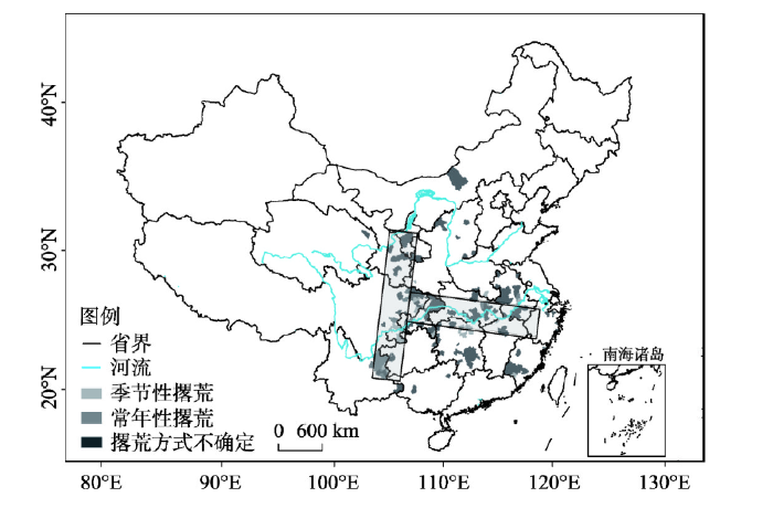 显示原图|下载原图ZIP|生成PPT
图1中国撂荒记录县域空间分布图
-->Fig. 1Spatial distribution of cropland abandonment at county level in China
-->
以省级行政区而论,湖南省撂荒记录的县(市)数量最多(24个),主要分布于湖南省的西部和中部地区,自南至北呈条带状。其次是四川、安徽、湖北、重庆,分别有23个、21个、17个、15个县(市),主要位于四川的东缘,安徽中部和南部,湖北东南部和重庆全境。再次是福建(11个)、甘肃(11个)、云南(10个)、江西(7个)等4省。其余各省有撂荒记录的县(市)均不超过5个,其中东北三省、山东、广东、新疆和西藏未见有关县(市)的撂荒记录。
大多数研究论文未提及撂荒的方式,从仅有的38个县(市)的撂荒方式记录看,季节性撂荒和常年性撂荒交错分布。季节性撂荒记录较多,广泛分布于四川东部、湖南北部、云南东部、陕西西南部、重庆东南部、湖北东部、河南南部、江西北部、安徽中部以及福建西南部。其中,四川东部的季节性撂荒以小春撂荒为主。常年性撂荒主要分布在云南东北部、四川东部、重庆西部、湖北东部、安徽中部以及福建东部。
3.2 撂荒的时空变化
分时段看,撂荒县(市)的空间分布格局随时间而变(图2),由最初主要沿长江中下游的东西向分布,变为自甘肃东南部至贵州西部和云南北部的南北向分布,即:先出现逆时针旋转90°的“T”字型的横轴,再出现纵轴,时间拐点大致为2010年前后。如图2所示,2010年之前,有撂荒记录的县(市)主要位于长江中下游地区。其中,2000年之前,仅45个县(市)有撂荒记录,主要出现于重庆、湖北、湖南,以及安徽和江西的局部地区。2000-2009年,新增57个县(市),这些新增县(市)集中分布于长江中下游,自西至东分布于四川东部、重庆、湖北南部和安徽中南部。在此期间,湖南南部、福建南部和浙江局部地区的部分县(市)也出现了撂荒记录。2010-2017年,再增63个县(市),但是其主要分布格局已不再是沿长江中下游的东西向带状,而是转变为自甘肃东南部至贵州西部和云南北部的南北条带状集中分布。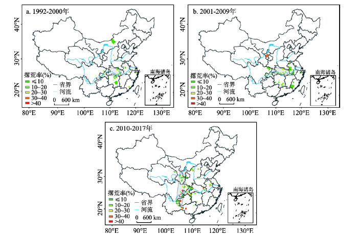 显示原图|下载原图ZIP|生成PPT
图2中国不同时期县域单元的撂荒程度及空间分布
-->Fig. 2Spatial distribution of cropland abandonment at county level in China in each stage
-->
伴随着撂荒记录县(市)的增加和空间分布的变化,撂荒率也呈逐渐增加的趋势。根据调查数据,从1992-2000年到2001-2009年,撂荒率超过30%的县(市)由零增至4个,到2010-2017年,再新增11个。其中,撂荒最严重的地区为四川东部的宜宾市,撂荒率高达62.03%,其次为贵州西部的六盘水市水城县,撂荒率为61.1%;另外四川东部的遂宁市中区、广西的百色市田东县,湖北东北部的黄冈市红安县的撂荒率均超过40%。
3.3 撂荒的直接因素
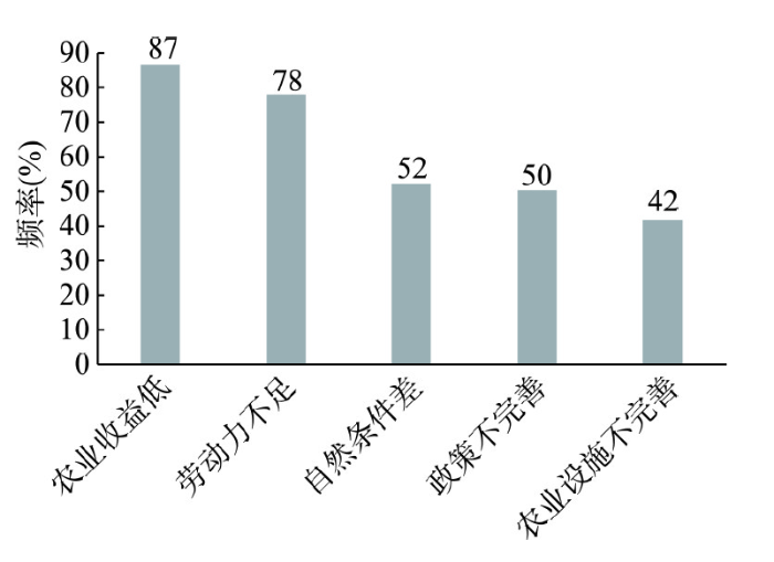
根据公开发表论文的相关结论,撂荒形成因素大致可分为五类。第一类因素可归结为农业收益低,主要由于农业生产规模小,农产品售价低,化肥等农资价格上涨,农业成本高,致使农业活动收益低。如,在湖南省安仁县,每亩耕地毛收入为560元,扣除机耕、化肥、农药等费用后每亩耕地收益仅有372元,一年可收入1264.8元,而外出打工扣除生活费用外,人均每年纯收入2300元[22]。第二类因素为劳动力不足,大量劳动力向城镇转移。如,湖南省安仁县外出劳动力已达40%以上,武胜县某村的壮劳人口80%以上外出务工[22,23]。第三类因素为自然条件较差,导致农民被迫撂荒,如土地贫瘠,位置偏远,污染严重,野生动物的破坏等。如,湖北省孝感市因病虫灾害致使每年15%~25%的农田减产幅度超过2成[24]。第四类因素为政策不完善,主要是缺少有效的土地流转机制。如,武胜县在2000-2007年2.29万人由农业人口转为城镇人口,这2.29万人在第二轮土地延包时基本上都分到耕地,但由于缺少土地流转机制,部分耕地因没有进行有效流转而撂荒[23]。第五类因素为农业设施不完善,包括生产技术水平较低,农业设施老化,水利条件差等。如,重庆市秀山县因财政投入不足,设施年久失修,旱不能浇、涝不能排,由此导致的撂荒面积占撂荒耕地的约15%[17]。在上述5类撂荒形成因素中,出现频率最高的是农业收益低,达86%(图3),位居第二的是劳动力不足,出现频率为78%。自然条件差和政策不完善位居其后,出现的频率分别为52%和53%,农业设施不完善出现的频率最低,为42%。由此可见,撂荒是多种因素共同作用的结果,其中大部分县(市)撂荒的共同形成因素是农业收益低和劳动力不足,部分县(市)撂荒的原因涉及自然条件差和政策不完善,而农业设施不完善对撂荒的贡献较小。
 显示原图|下载原图ZIP|生成PPT
图3导致撂荒的主要因素的出现频率
-->Fig. 3Frequencies of the main determinants of cropland abandonment
-->
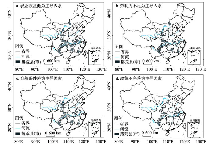
农业收益低,作为撂荒形成的首要因素,广泛出现于撂荒集中分布区,在“T”字型纵轴和横轴均有广泛分布(图4)。劳动力不足,作为撂荒形成的第二位因素,在“T”字型的纵轴地带广泛分布,而在横轴地带分布密度相对较低,主要出现在湖北东南部和安徽中南部。自然条件差和政策不完善,作为撂荒形成的第三和第四位因素,主要出现在“T”字型纵轴地带,而在横轴地带的分布密度进一步降低。由此突显,2010年以后出现的“T”字型纵轴地带的撂荒是多种因素共同导致的结果,此前长江中下游东西带状的撂荒则主要由农业收益低所致,其他因素的影响相对较弱。
 显示原图|下载原图ZIP|生成PPT
图4中国撂荒形成因素的空间分布
-->Fig. 4Spatial distribution of the main drivers of cropland abandonment in China
-->
3.4 撂荒的社会经济背景
撂荒本质上是社会经济发展、产业转型与第一产业劳动力析出的产物[2, 25]。为深入理解上述地区撂荒的社会经济背景,本文对撂荒地区省域单元的经济水平和农业从业人口进行了分析。就经济水平而言(表1),20世纪90年代至今,撂荒“T”字型区域主要省份的人均GDP均呈现大幅增加,2012-2016年相对于1992-1996年的最大增幅为66540元(浙江省,年均增长率9.4%),最小增幅也达24896元(贵州省,年均增长率11.45%)。其中,2002-2011年间增速普遍最高,浙江、福建、安徽、江西、湖北、湖南、四川的年均增长率分别为14.1%、13.1%、14.2%、15.4%、15.4%、15.5%、14.9%,较1992-2001年和2012-2016年增长率分别平均偏高3.6%和1.7%。与此相对应的是,21世纪前10年的撂荒记录数也显著多于前、后两个时期。贵州省的人均GDP增长率则表现为持续增加,2012-2016年的年增长率高达17.9%,高于2002-2011年的16.3%。重庆市的人均GDP也保持强劲增长,2010-2015年的增长率为14.5%,仅仅略低于2000-2010年的15.1%,并在所有省份中仅次于贵州,位居第二。与此相应,2010年以后贵州与重庆两地仍然维持较多的撂荒记录数。Tab. 1
表1
表1撂荒“T”字型区域主要省份的人均GDP(千元)
Tab. 1Gross Domestic Product (GDP) per capita (103 yuan) of each province in the T-shaped area of cropland abandonment in China
| 年份 | 浙江 | 福建 | 安徽 | 江西 | 湖北 | 湖南 | 四川 | 重庆 | 贵州 |
|---|---|---|---|---|---|---|---|---|---|
| 1992-1996 | 7.03 | 5.71 | 2.89 | 2.65 | 3.36 | 2.99 | 2.72 | 3.42 | 1.65 |
| 1997-2001 | 12.46 | 10.32 | 4.75 | 4.50 | 5.76 | 5.11 | 4.64 | 5.97 | 2.58 |
| 2002-2006 | 23.82 | 16.51 | 7.68 | 8.23 | 10.13 | 9.24 | 8.02 | 10.84 | 4.59 |
| 2007-2011 | 46.61 | 35.24 | 17.89 | 18.79 | 24.20 | 21.61 | 18.62 | 24.43 | 11.66 |
| 2012-2016 | 73.58 | 63.26 | 34.06 | 33.04 | 46.85 | 38.42 | 33.53 | 48.04 | 26.55 |
新窗口打开
从农业从业人口占比看(表2),20世纪90年代至今,撂荒“T”字型区域主要省份的农业从业人口比重均呈持续降低的态势,最大降幅为-38.4%(重庆市,从67.3%降至28.9%),最小降幅为20.8%(贵州省,从78.1%降至57.3%)。与人均GDP的增长率相对应,2000-2010年是农业从业人口比重的降低速率较大的时期,农业从业人口比重最大年均降幅为2.05%(安徽省),最小也高达0.18%(湖北省),均普遍大于1990-2000年的年均降幅。与此相应,2000-2010年各省的撂荒记录数均多于1990-2000年,撂荒现象频发。而贵州和重庆,2010-2016年间仍维持较大的降幅,年均降幅分别为2.20%和2.29%,而2000-2010年间年均降幅均仅为1.5%。与此对应,贵州和重庆2010年以后撂荒记录数持续增加,并且均多于2000-2010年。
Tab. 2
表2
表2撂荒“T”字型区域主要省份的农业从业人员占比(%)
Tab. 2Percentage of agricultural employees against total population of each province within the T-shaped area of cropland abandonment in China (%)
| 年份 | 浙江 | 福建 | 安徽 | 江西 | 湖北 | 湖南 | 四川 | 重庆 | 贵州 |
|---|---|---|---|---|---|---|---|---|---|
| 1990年 | 53.2 | 58.4 | 68.8 | 66.1 | 43.1 | 72.3 | 72.5 | 70.3 | 78.2 |
| 2000年 | 33.7 | 47.8 | 75.0 | 68.4 | 66.4 | 75.0 | 77.6 | 72.8 | 81.8 |
| 2010年 | 14.7 | 28.3 | 54.2 | 44.4 | 53.1 | 55.9 | 60.2 | 50.3 | 68.9 |
| 2016年 | 12.4 | 22.0 | 31.7 | 30.0 | 36.8 | 40.7 | 38.6 | 28.9 | 57.3 |
新窗口打开
伴随着农业从业人数的减少,粮食播种面积和复种指数也总体呈现减少趋势(表3)。“T”字型区域主要省份总的粮食播种面积由36985 hm2(1992-1996年平均)减至33931 hm2(2012-2016年平均),其中2000-2010年是年均减幅最大的时段,年均减少多达340 hm2,而1992-2000年年均减少仅为113 hm2,2010-2016年则是年均增加92 hm2。其中,浙江、湖北、湖南、江西、重庆、四川的粮食播种面积减幅较大,并且也主要出现在2000-2010年。与此同时,各省复种指数不同程度下降,如:浙江和福建的复种指数由1992-1995年的1.75和1.66分别降至2013-2015年的0.64和0.9;四川和湖北的复种指数由1.37和1.43分别降至0.96和0.83。安徽和贵州两省的粮食播种面积不降反升,其中安徽升幅稍大,由5917 hm2(1992-1996年平均)升至6632 hm2(2012-2016年平均),贵州升幅甚微。但是,两省的复种指数也逐步下降,贵州的复种指数由1992-1995年的1.31,逐渐降至2013-2015年的0.62,安徽的复种指数由1.37降至1.13,降幅是所有省份中最小的。这可能与安徽省作为一个农业大省和国家粮食主产区之一,粮食生产一直是重点发展产业有关。
Tab. 3
表3
表3撂荒“T”字型区域主要省份的粮食播种面积(103 hm2)
Tab. 3Grain sown area of each province within the T-shaped area of cropland abandonment in China (103 hm2)
| 年份 | 浙江 | 福建 | 安徽 | 江西 | 湖北 | 湖南 | 四川 | 重庆 | 贵州 |
|---|---|---|---|---|---|---|---|---|---|
| 1992-1996 | 2888 | 2021 | 5918 | 3463 | 4844 | 5124 | 7057 | - | 2782 |
| 1997-2001 | 2533 | 1927 | 5996 | 3427 | 4503 | 5040 | 7065 | 2832 | 3093 |
| 2002-2006 | 1461 | 1450 | 6283 | 3316 | 3796 | 4664 | 6359 | 2450 | 3009 |
| 2007-2011 | 1262 | 1220 | 6576 | 3599 | 4018 | 4722 | 6422 | 2229 | 2964 |
| 2012-2016 | 1263 | 1192 | 6633 | 3695 | 4383 | 4937 | 6461 | 2245 | 3121 |
新窗口打开
4 结论与讨论
4.1 结论
本文采用荟萃分析方法,在前人对县(市)撂荒研究的基础上,揭示了国家尺度耕地撂荒变化的时空特征及形成因素的空间分布。1992-2017年有撂荒记录的163个县(市)分布于全国20余个省份,但是集中分布于南方,且基本呈逆时针旋转90°的“T”字型,其纵轴自北至南贯穿甘肃东南部、四川东部、重庆境内,直至贵州西部和云南北部;横轴位于长江中下游地区,自西向东贯穿湖北南部、湖南北部、安徽中部和南部。“T”字型的形成经历两个阶段,2010年之前撂荒记录县市主要出现在长江中下游东西向带状地区,此后则主要出现于自甘肃东南部至贵州西部和云南北部的南北向带状地区。撂荒格局的形成过程与区域经济发展和产业结构调整背景下的农业劳动力析出基本同步。农业收益低和劳动力不足是大部分县(市)撂荒形成的共性因素;部分县(市)撂荒的原因涉及自然条件差和制度不完善。4.2 讨论
与已有撂荒时空分布特征研究相比,本文采用大数据分析的思路,通过对已有研究的荟萃分析,发现了中国撂荒现象分布的“T”字型格局,以及“T”字型格局中先东西向、后南北向的形成过程。本研究不仅支持了李升发等[18]发现的国家尺度撂荒宏观格局,而且更加详细的描述了撂荒的空间分布格局及其时间演变特征,以及撂荒形成因素的空间分布格局。这为深入研究撂荒的社会经济和自然环境效应提供了基础数据,为利用卫星遥感定量研究撂荒的分布范围提供了依据。同时,本文以实证的方式印证了基于前人个例研究的大数据分析思路在地理事件时空分布研究中的实用性和有效性。但是,本研究尚有一定的不确定性,突出表现为收集的样本仅限于已经发表的论文。为进一步丰富样本量,更加详细的刻画中国撂荒的时空分布特征,未来有必要在大数据思想指导下,采用网络爬虫工具,检索相关的网络数据。另外,从公开发表论文中提取的部分撂荒率数据源自对县(市)范围内部分村、镇的调查,为更科学的估算县(市)平均撂荒率,有必要进一步深入研究被调查村、镇对县(市)整体状况的代表性,以降低本研究关于部分县(市)撂荒率估算结果的不确定性。最后,地面调查固然是数据获取的有效途径,但是受限于财力和人力,难以开展全面的地面调查,而卫星遥感的优势则是空间全面覆盖。因此,在本研究结果的指引下,利用卫星遥感开展全面的撂荒率估算,分析撂荒程度的时空变化,也是本领域的研究方向之一。
The authors have declared that no competing interests exist.
参考文献 原文顺序
文献年度倒序
文中引用次数倒序
被引期刊影响因子
| [1] | . |
| [2] | . 20世纪后半叶以来许多发达国家发生明显的耕地撂荒现象,并逐渐演变为全球性土地利用现象,深刻地改变了广大农村地区土地景观。本文以"土地利用变化—驱动机制—环境效应—政策响应"的框架系统梳理耕地撂荒主要研究进展。研究表明:1全球耕地撂荒仍主要发生在欧美发达国家,但发展程度的区域差异很大;2社会经济要素变化是耕地撂荒最主要驱动力,务农机会成本上升等原因引起的耕地边际化是撂荒发生的根本原因,而劳动力析出是造成耕地撂荒的直接原因;3耕地撂荒与否、撂荒程度以及撂荒地空间分布受村镇、农户、地块三个尺度的自然条件、劳动力特征、农业生产条件和区域社会经济条件等多方面因素的综合影响;4生态环境效应是当前撂荒效应研究的焦点,但该效应是以积极还是消极为主仍存争议;5增加农业补贴是当前减缓耕地撂荒的主要措施,但并非唯一和最合理的措施。未来,快速城镇化进程将促使中国耕地撂荒现象愈演愈烈,所以当前研究有待加强,本文认为应加强大范围耕地撂荒信息提取和监测、撂荒趋势预测和风险评估、社会经济效应评估及政策设计等方面研究。 . 20世纪后半叶以来许多发达国家发生明显的耕地撂荒现象,并逐渐演变为全球性土地利用现象,深刻地改变了广大农村地区土地景观。本文以"土地利用变化—驱动机制—环境效应—政策响应"的框架系统梳理耕地撂荒主要研究进展。研究表明:1全球耕地撂荒仍主要发生在欧美发达国家,但发展程度的区域差异很大;2社会经济要素变化是耕地撂荒最主要驱动力,务农机会成本上升等原因引起的耕地边际化是撂荒发生的根本原因,而劳动力析出是造成耕地撂荒的直接原因;3耕地撂荒与否、撂荒程度以及撂荒地空间分布受村镇、农户、地块三个尺度的自然条件、劳动力特征、农业生产条件和区域社会经济条件等多方面因素的综合影响;4生态环境效应是当前撂荒效应研究的焦点,但该效应是以积极还是消极为主仍存争议;5增加农业补贴是当前减缓耕地撂荒的主要措施,但并非唯一和最合理的措施。未来,快速城镇化进程将促使中国耕地撂荒现象愈演愈烈,所以当前研究有待加强,本文认为应加强大范围耕地撂荒信息提取和监测、撂荒趋势预测和风险评估、社会经济效应评估及政策设计等方面研究。 |
| [3] | . Cropland abandonment has emerged as a prevalent phenomenon in the mountainous areas of China. While there is a general understanding that this new trend is driven by the rising opportunity cost of rural labor, rigorous theoretical and empirical analyses are largely absent. This paper first develops a theoretical model to investigate household decisions on farming scale when off-farm labor market is accessible and there is heterogeneity of farmland productivity and distribution. The model is capable of explaining the hidden reasons of cropland abandonment in sloping and agriculturally less-favored locations. The model also unveils the impacts of heterogeneity of household labor on fallow decisions and the efficiency loss due to an imperfect labor market. The model is empirically tested by applying the Probit and Logit estimators to a unique household and land-plot survey dataset which contains 5258 plots of 599 rural households in Chongqing, a provincial level municipality, in Southwest China. The survey shows that more than 30% of the sample plots have been abandoned, mainly since 1992. The econometric results are consistent with our theoretical expectations. This work would help policy-makers and stakeholders to identify areas with a high probability of land abandonment and farming practice which is less sustainable in the mountainous areas. |
| [4] | . Farmland abandonment is a type of land use change in the mountainous areas, and this change is under rapid development. Whether farmland transfer can prevent this process or not and promote the effective allocation of land resources is a question worth studying and discussing. With the help of the previous research findings, the objective of this paper was to find out the role of farmland transfer on mitigating farmland abandonment, by using the multiple view methods with two factors, and single factor correlation analysis. The results showed that: (1) At village level, there was a significant negative correlation between farmland transfer and farmland abandonment, especially for the farmland with high grade farming conditions, which indicated that farmland transfer could prevent the abandonment of farmland with high grade farming conditions. (2) At plot level, the abandonment rate of farmland with high grade farming conditions was significantly lower than that with poor grade farming conditions. Abandoned farmland was mainly the grade farming conditions in the study site. (3) At village level, the role of farming conditions on farmland abandonment was insignificant. The farming condition to the difference of farmland abandonment rate at village level was not obvious. The abandonment of farmland with high farming conditions still existed, which illustrated that farmland transfer, as one of the land rental markets, was still not developed. (4) However, for the villages with higher rate of farmland transfer, there was lower abandonment rate for those high grade farming conditions, which incicated that farmland abandonment was still controlled by the improvement of land rental market. Furthermore, the function of land rental market played an important role in optimizing the utilization of farmland resources. (5) To further improve the marketing degree of land rent, the probability of farmland abandonment could be reduced. Especially, their function to farmland with high grade farming conditions was very obvious, and could avoid the waste of farmland resources with high grade farming conditions. . Farmland abandonment is a type of land use change in the mountainous areas, and this change is under rapid development. Whether farmland transfer can prevent this process or not and promote the effective allocation of land resources is a question worth studying and discussing. With the help of the previous research findings, the objective of this paper was to find out the role of farmland transfer on mitigating farmland abandonment, by using the multiple view methods with two factors, and single factor correlation analysis. The results showed that: (1) At village level, there was a significant negative correlation between farmland transfer and farmland abandonment, especially for the farmland with high grade farming conditions, which indicated that farmland transfer could prevent the abandonment of farmland with high grade farming conditions. (2) At plot level, the abandonment rate of farmland with high grade farming conditions was significantly lower than that with poor grade farming conditions. Abandoned farmland was mainly the grade farming conditions in the study site. (3) At village level, the role of farming conditions on farmland abandonment was insignificant. The farming condition to the difference of farmland abandonment rate at village level was not obvious. The abandonment of farmland with high farming conditions still existed, which illustrated that farmland transfer, as one of the land rental markets, was still not developed. (4) However, for the villages with higher rate of farmland transfer, there was lower abandonment rate for those high grade farming conditions, which incicated that farmland abandonment was still controlled by the improvement of land rental market. Furthermore, the function of land rental market played an important role in optimizing the utilization of farmland resources. (5) To further improve the marketing degree of land rent, the probability of farmland abandonment could be reduced. Especially, their function to farmland with high grade farming conditions was very obvious, and could avoid the waste of farmland resources with high grade farming conditions. |
| [5] | . 农地集约度下降、季节性闲置和常年撂荒是农地边际化现象之一。即使在当前惠农政策背景下,我国中部丘陵山区依然大量存在这种农地边际化现象。经过理论分析与实证,其原因如下:1.在工业化城镇化进程中,由于农业劳动存在较高的机会成本,导致丘陵山区农民非农化现象突出,农地集约利用程度下降;2.丘陵山区农业生态条件较差,农地边际收益较低;3.国家惠农政策的激励作用在丘陵山区存在相对失灵;生态政策与农业政策的不协调,对农业生产存在负外部性,从而加剧了当地的农地边际化。解决丘陵山区农地边际化问题的途径在于农业技术和组织制度的创新,改善农业生产环境,发展合作经济组织和特色农业,提高农地的边际效益;国家农业政策要因地制宜,并与生态政策协调一致。 . 农地集约度下降、季节性闲置和常年撂荒是农地边际化现象之一。即使在当前惠农政策背景下,我国中部丘陵山区依然大量存在这种农地边际化现象。经过理论分析与实证,其原因如下:1.在工业化城镇化进程中,由于农业劳动存在较高的机会成本,导致丘陵山区农民非农化现象突出,农地集约利用程度下降;2.丘陵山区农业生态条件较差,农地边际收益较低;3.国家惠农政策的激励作用在丘陵山区存在相对失灵;生态政策与农业政策的不协调,对农业生产存在负外部性,从而加剧了当地的农地边际化。解决丘陵山区农地边际化问题的途径在于农业技术和组织制度的创新,改善农业生产环境,发展合作经济组织和特色农业,提高农地的边际效益;国家农业政策要因地制宜,并与生态政策协调一致。 |
| [6] | . |
| [7] | . 近年来,耕地撂荒因与耕地流失及粮食安全紧密联系而备受关注。反映撂荒现状并揭示其影响因素,有利于政府制定科学的政策、规划和计划。现有的研究多将农户作为一个整体,较少考虑到不同类型农户撂荒的差异。以重庆市12个典型村为例,在农户类型划分的基础上,分析不同类型农户撂荒的差异,运用多元线性回归模型定量分析不同类型农户撂荒的影响因素。研究表明:①不同类型农户撂荒的差异主要体现在撂荒户数比重、户均撂荒面积、撂荒面积占承包地面积比重随耕作半径的变化情况、撂荒地现状及不同时间段撂荒面积;②野生动物影响和人均耕地面积是影响不同类型农户撂荒的共同原因。此外,影响基本型农户的因素包括户主外出经历、耕作半径和房屋离集镇距离;影响自然资产型农户的因素包括农业劳动力比重、户主外出经历、地块平均面积和耕地收益;影响人力资产型农户的因素包括家庭人口、非农收入、耕地转出面积和耕作半径。 . 近年来,耕地撂荒因与耕地流失及粮食安全紧密联系而备受关注。反映撂荒现状并揭示其影响因素,有利于政府制定科学的政策、规划和计划。现有的研究多将农户作为一个整体,较少考虑到不同类型农户撂荒的差异。以重庆市12个典型村为例,在农户类型划分的基础上,分析不同类型农户撂荒的差异,运用多元线性回归模型定量分析不同类型农户撂荒的影响因素。研究表明:①不同类型农户撂荒的差异主要体现在撂荒户数比重、户均撂荒面积、撂荒面积占承包地面积比重随耕作半径的变化情况、撂荒地现状及不同时间段撂荒面积;②野生动物影响和人均耕地面积是影响不同类型农户撂荒的共同原因。此外,影响基本型农户的因素包括户主外出经历、耕作半径和房屋离集镇距离;影响自然资产型农户的因素包括农业劳动力比重、户主外出经历、地块平均面积和耕地收益;影响人力资产型农户的因素包括家庭人口、非农收入、耕地转出面积和耕作半径。 |
| [8] | . Abstract The main objective of the present study was to investigate the effects of cropland abandonment on soil erodibility as measured by soil resistance to concentrated flow and sediment yield. |
| [9] | . Abstract The break-up of the Soviet Union in 1991 triggered cropland abandonment on a continental scale, which in turn led to carbon accumulation on abandoned land across Eurasia. Previous studies have estimated carbon accumulation rates across Russia based on large-scale modelling. Studies that assess carbon sequestration on abandoned land based on robust field sampling are rare. We investigated soil organic carbon (SOC) stocks using a randomized sampling design along a climatic gradient from forest steppe to Sub-Taiga in Western Siberia (Tyumen Province). In total, SOC contents were sampled on 470 plots across different soil and land-use types. The effect of land use on changes in SOC stock was evaluated, and carbon sequestration rates were calculated for different age stages of abandoned cropland. While land-use type had an effect on carbon accumulation in the topsoil (0-50002cm), no independent land-use effects were found for deeper SOC stocks. Topsoil carbon stocks of grasslands and forests were significantly higher than those of soils managed for crops and under abandoned cropland. SOC increased significantly with time since abandonment. The average carbon sequestration rate for soils of abandoned cropland was 0.660002Mg0002C0002ha -1 0002yr -1 (1-200002years old, 0-50002cm soil depth), which is at the lower end of published estimates for Russia and Siberia. There was a tendency towards SOC saturation on abandoned land as sequestration rates were much higher for recently abandoned (1-100002years old, 1.040002Mg0002C0002ha -1 0002yr -1 ) compared to earlier abandoned crop fields (11-200002years old, 0.260002Mg0002C0002ha -1 0002yr -1 ). Our study confirms the global significance of abandoned cropland in Russia for carbon sequestration. Our findings also suggest that robust regional surveys based on a large number of samples advance model-based continent-wide SOC prediction. 0008 2017 John Wiley & Sons Ltd. |
| [10] | . Since the 1950s, noteworthy farmland abandonment has been occurring in many developed countries and some developing countries. This global land use phenomenon has fundamentally altered extensive rural landscapes. A review of global farmland abandonment under the headings of “land use change–driving mechanisms–impacts and consequences–policy responses” found the following: (1) Farmland abandonment has occurred primarily in developed countries in Europe and North America, but the extent of abandonment has varied significantly. (2) Changing socio-economic factors were the primary driving forces for the farmland abandonment. And land marginalization was the fundamental cause, which was due to the drastic increase of farming opportunity cost, while the direct factor for abandonment was the shrink of agricultural labor forces. (3) Whether to abandon, to what extent and its spatial distributions were finally dependent on integrated effect from the physical conditions, laborer attributes, farming and regional socio-economic conditions at the village, household and parcel scales. With the exception of Eastern Europe, farmland abandonment was more likely to occur in mountainous and hilly areas, due to their unfavorable farming conditions. (4) A study of farmland abandonment should focus on its ecological and environmental effects, while which is more positive or more negative are still in dispute. (5) Increasing agricultural subsidies will be conductive to slowing the rate of farmland abandonment, but this is not the only measure that needs to be implemented.Due to China’s rapid urbanization, there is a high probability that the rate of abandonment will increase in the near future. However, very little research has focused on this rapid land-use trend in China, and, as a result, there is an inadequate understanding of the dynamic mechanisms and consequences of this phenomenon. This paper concludes by suggesting some future directions for further research in China. These directions include monitoring regional and national abandonment dynamics, analyzing trends, assessing the risks and socio-economic effects of farmland abandonment, and informing policy making. |
| [11] | . 耕地撂荒是20世纪80年代后期以来我国非农经济发达地区面临的 重要问题,浙江沿海更为突出,是建设社会主义新农村必须面对的现实问题.在深入实地调查研究的基础上,以浙江省余姚市低塘街道为例,分析了 1992~2005年低塘街道耕地撂荒的时间变化过程、空间分布特点及引起耕地撂荒的经济和社会原因,为长三角地区耕地撂荒问题提供分析案例. . 耕地撂荒是20世纪80年代后期以来我国非农经济发达地区面临的 重要问题,浙江沿海更为突出,是建设社会主义新农村必须面对的现实问题.在深入实地调查研究的基础上,以浙江省余姚市低塘街道为例,分析了 1992~2005年低塘街道耕地撂荒的时间变化过程、空间分布特点及引起耕地撂荒的经济和社会原因,为长三角地区耕地撂荒问题提供分析案例. |
| [12] | . 鉴于西南山区农村土地抛荒现象日益突现,有必要找到引起这一现象的原因所在,并结合农业和农村经济发展的新特点。提出多措并举综合治理。以重庆市忠县三汇镇土地抛荒为例,通过调查,研究整个西南地区土地抛荒情况,归纳总结了解决问题的方法,希望能引起各界对西南山区农村土地抛荒现象的重视。 . 鉴于西南山区农村土地抛荒现象日益突现,有必要找到引起这一现象的原因所在,并结合农业和农村经济发展的新特点。提出多措并举综合治理。以重庆市忠县三汇镇土地抛荒为例,通过调查,研究整个西南地区土地抛荒情况,归纳总结了解决问题的方法,希望能引起各界对西南山区农村土地抛荒现象的重视。 |
| [13] | . 应用GIS空间分析方法研究撂荒地微观空间分布特征,为解决撂荒地提出了有操作性的对策;同时,采用GIS空间分析法和文献资料法对撂荒地空间分布特征进行了研究。研究结果:一是撂荒地主要分布在远离场镇、交通条件差、灌溉设施缺乏、坡度较大、土地肥力低的地方;二是水田撂荒少,旱地撂荒多,道路交通两侧表现得最为明显;三是撂荒地分布和坡向无显著相关性。研究结论:一是加大基础设施建设,改善生产条件;二是大力调整农业产业结构,做到地尽其用;三是创新土地流转方式,推动适度规模经营;四是改革农地产权,建立退出机制。 . 应用GIS空间分析方法研究撂荒地微观空间分布特征,为解决撂荒地提出了有操作性的对策;同时,采用GIS空间分析法和文献资料法对撂荒地空间分布特征进行了研究。研究结果:一是撂荒地主要分布在远离场镇、交通条件差、灌溉设施缺乏、坡度较大、土地肥力低的地方;二是水田撂荒少,旱地撂荒多,道路交通两侧表现得最为明显;三是撂荒地分布和坡向无显著相关性。研究结论:一是加大基础设施建设,改善生产条件;二是大力调整农业产业结构,做到地尽其用;三是创新土地流转方式,推动适度规模经营;四是改革农地产权,建立退出机制。 |
| [14] | . Cropland abandonment accompanying economic development has been observed worldwide. China has experienced a large amount of land abandonment in recent years. However, the reasons for it are not entirely clear. Although abandonment decisions are made by individual households, the underlying conditions reflect processes operating at multiple levels. Therefore, we aimed to detect the influences on land abandonment at the parcel, household and village levels. We developed and employed a multi-level statistical model using farm household survey data and geographical maps of Wulong County. Our model revealed that of the variance in occurrence of land parcel abandonment, 7% and 13% can be explained at the household and village levels, respectively, while the remnant 80% can be explained at the land parcel features itself. We found that land abandonment is more prone to occur on parcels that are on steep slopes, have poor quality soil, or are remote from the laborers residences. Households with less agricultural labor per unit land area showed a high probability of land abandonment. We also found a nonlinear influence of labor age on land abandonment, with households comprising middle-aged laborers having a low land abandonment probability. Parcels in villages with high elevation, far from the county administrative center or with low prevalence of leased land are inclined to abandonment. We also found, surprisingly, that the household proportion of males among its agricultural laborers did not significantly influence the occurrence of land abandonment at the parcel level, probably due to the male agricultural laborers being overwhelmingly old (average age greater than 56 years). To alleviate land abandonment, we suggest improving land tenure and transfer security to ensure stable access to the land rental market, and also improving infrastructure in remote regions. |
| [15] | . 61We examined how two main farmland parcel attributes determined farmland abandonment.61Farmland-to-housing distance and land quality affected farming costs and benefits.61We constructed a semi-empirical crop profit model based on output benefits and input costs.61Zero profit distance (ZPD) values were used to predict the patterns of land abandonment.61ZPD values range from 1.4802km to 5.9402km according to different land quality class. |
| [16] | . 以陕西省汉中市汉台区为对象,实地考察了汉台区4个乡镇的耕地撂荒情况,分析了农村耕地撂荒情势,总结了耕地撂荒的各种原因,提出应以增加农业基础设施投入,提高耕地产出效益,加快土地流转等多种措施并举,从而减少耕地撂荒的有效对策. . 以陕西省汉中市汉台区为对象,实地考察了汉台区4个乡镇的耕地撂荒情况,分析了农村耕地撂荒情势,总结了耕地撂荒的各种原因,提出应以增加农业基础设施投入,提高耕地产出效益,加快土地流转等多种措施并举,从而减少耕地撂荒的有效对策. |
| [17] | . 农村耕地撂荒直接关系着国家粮食安全和农村经济发展,结合秀山县农村耕撂荒的现状,分析了造成耕地撂荒的主要原因,提出了遏制耕地撂荒的对策。 . 农村耕地撂荒直接关系着国家粮食安全和农村经济发展,结合秀山县农村耕撂荒的现状,分析了造成耕地撂荒的主要原因,提出了遏制耕地撂荒的对策。 |
| [18] | . 耕地撂荒是当前全球山区主要的土地利用变化现象,它深刻地改变了山区农村土地利用结构、农业景观和农户生计,并带来了巨大的生态环境和社会经济效应.2000年以来,随着中国劳动力成本的快速上升和农村劳动力的大量析出,中国山区农业因地形限制,机械化发展受阻,耕地面临着较大的撂荒风险.越来越多的案例研究和报道表明中国山区耕地撂荒现象越演越烈.中国山区面积广、坡耕地比重大,耕地撂荒不仅关系到山区农地的合理利用政策和山区可持续发展政策的制定,并可能引起粮食安全问题,但目前仍缺少全国层面的定量化评估研究.因此,本研究通过开展大范围的抽样调查对中国山区县撂荒规模进行了推算,以期为相关政策制定以及耕地边际化进一步研究提供参考.研究结果表明,在235个调查村庄中,78.3%的村庄出现耕地撂荒现象;基于县样本统计的2014-2015年全国山区县耕地撂荒率为14.32%;山区耕地撂荒率在省级尺度上呈现出南高北低的空间格局,其中,长江流域一带的山区耕地撂荒率最高,东北的长白山区最低. . 耕地撂荒是当前全球山区主要的土地利用变化现象,它深刻地改变了山区农村土地利用结构、农业景观和农户生计,并带来了巨大的生态环境和社会经济效应.2000年以来,随着中国劳动力成本的快速上升和农村劳动力的大量析出,中国山区农业因地形限制,机械化发展受阻,耕地面临着较大的撂荒风险.越来越多的案例研究和报道表明中国山区耕地撂荒现象越演越烈.中国山区面积广、坡耕地比重大,耕地撂荒不仅关系到山区农地的合理利用政策和山区可持续发展政策的制定,并可能引起粮食安全问题,但目前仍缺少全国层面的定量化评估研究.因此,本研究通过开展大范围的抽样调查对中国山区县撂荒规模进行了推算,以期为相关政策制定以及耕地边际化进一步研究提供参考.研究结果表明,在235个调查村庄中,78.3%的村庄出现耕地撂荒现象;基于县样本统计的2014-2015年全国山区县耕地撂荒率为14.32%;山区耕地撂荒率在省级尺度上呈现出南高北低的空间格局,其中,长江流域一带的山区耕地撂荒率最高,东北的长白山区最低. |
| [19] | . The effects of land use change on soil carbon stocks are of concern in the context of international policy agendas on greenhouse gas emissions mitigation. This paper reviews the literature for the influence of land use changes on soil C stocks and reports the results of a meta analysis of these data from 74 publications. The meta analysis indicates that soil C stocks decline after land use changes from pasture to plantation (6110%), native forest to plantation (6113%), native forest to crop (6142%), and pasture to crop (6159%). Soil C stocks increase after land use changes from native forest to pasture (+ 8%), crop to pasture (+ 19%), crop to plantation (+ 18%), and crop to secondary forest (+ 53%). Wherever one of the land use changes decreased soil C, the reverse process usually increased soil carbon and vice versa . As the quantity of available data is not large and the methodologies used are diverse, the conclusions drawn must be regarded as working hypotheses from which to design future targeted investigations that broaden the database. Within some land use changes there were, however, sufficient examples to explore the role of other factors contributing to the above conclusions. One outcome of the meta analysis, especially worthy of further investigation in the context of carbon sink strategies for greenhouse gas mitigation, is that broadleaf tree plantations placed onto prior native forest or pastures did not affect soil C stocks whereas pine plantations reduced soil C stocks by 12–15%. |
| [20] | . The conversion of Earth's land surface to urban uses is one of the most irreversible human impacts on the global biosphere. It drives the loss of farmland, affects local climate, fragments habitats, and threatens biodiversity. Here we present a meta-analysis of 326 studies that have used remotely sensed images to map urban land conversion. We report a worldwide observed increase in urban land area of 58,000 km2from 1970 to 2000. India, China, and Africa have experienced the highest rates of urban land expansion, and the largest change in total urban extent has occurred in North America. Across all regions and for all three decades, urban land expansion rates are higher than or equal to urban population growth rates, suggesting that urban growth is becoming more expansive than compact. Annual growth in GDP per capita drives approximately half of the observed urban land expansion in China but only moderately affects urban expansion in India and Africa, where urban land expansion is driven more by urban population growth. In high income countries, rates of urban land expansion are slower and increasingly related to GDP growth. However, in North America, population growth contributes more to urban expansion than it does in Europe. Much of the observed variation in urban expansion was not captured by either population, GDP, or other variables in the model. This suggests that contemporary urban expansion is related to a variety of factors difficult to observe comprehensively at the global level, including international capital flows, the informal economy, land use policy, and generalized transport costs. Using the results from the global model, we develop forecasts for new urban land cover using SRES Scenarios. Our results show that by 2030, global urban land cover will increase between 430,000 km2and 12,568,000 km2, with an estimate of 1,527,000 km2more likely. |
| [21] | . Abstract <p>The change in the phenology of plants or animals reflects the response of living systems to climate change. Numerous studies have reported a consistent earlier spring phenophases in many parts of middle and high latitudes reflecting increasing temperatures with the exception of China. A systematic analysis of Chinese phenological response could complement the assessment of climate change impact for the whole Northern Hemisphere. Here, we analyze 1263 phenological time series (1960–2011, with 20+ years data) of 112 species extracted from 48 studies across 145 sites in China. Taxonomic groups include trees, shrubs, herbs, birds, amphibians and insects. Results demonstrate that 90.8% of the spring/summer phenophases time series show earlier trends and 69.0% of the autumn phenophases records show later trends. For spring/summer phenophases, the mean advance across all the taxonomic groups was 2.7502days decade611 ranging between 2.11 and 6.1102days decade611 for insects and amphibians, respectively. Herbs and amphibians show significantly stronger advancement than trees, shrubs and insect. The response of phenophases of different taxonomic groups in autumn is more complex: trees, shrubs, herbs and insects show a delay between 1.93 and 4.8402days decade611, while other groups reveal an advancement ranging from 1.10 to 2.1102days decade611. For woody plants (including trees and shrubs), the stronger shifts toward earlier spring/summer were detected from the data series starting from more recent decades (1980s–2000s). The geographic factors (latitude, longitude and altitude) could only explain 9% and 3% of the overall variance in spring/summer and autumn phenological trends, respectively. The rate of change in spring/summer phenophase of woody plants (1960s–2000s) generally matches measured local warming across 49 sites in China ( R02 = 02 610.33, P |
| [22] | . 为进一步贯彻中央一号文件精神,制止和杜绝农地撂荒,稳定和扩大粮食种植面积,实现农业增产、农民增收的目标,安仁县采取了一些行之有效的措施,通过多种 形式的宣传,全县人民家喻户晓,文件精神深入人心,农地撂荒现象得到了较大遏制,取得了一定成效. . 为进一步贯彻中央一号文件精神,制止和杜绝农地撂荒,稳定和扩大粮食种植面积,实现农业增产、农民增收的目标,安仁县采取了一些行之有效的措施,通过多种 形式的宣传,全县人民家喻户晓,文件精神深入人心,农地撂荒现象得到了较大遏制,取得了一定成效. |
| [23] | . 正近年来,国家不断加大对基本农田的保护力度,取消农业税,实施粮食直补、良种补贴、农机具购机补贴、农资综合直补等积极的支农惠农政策。为什么农民还要将赖以生存的土地撂荒,是轮作养地?还是土地过多?笔者带着这个问题,深入到武胜县乡村进行了详细了解。 . 正近年来,国家不断加大对基本农田的保护力度,取消农业税,实施粮食直补、良种补贴、农机具购机补贴、农资综合直补等积极的支农惠农政策。为什么农民还要将赖以生存的土地撂荒,是轮作养地?还是土地过多?笔者带着这个问题,深入到武胜县乡村进行了详细了解。 |
| [24] | . 耕地撂荒已经成为全国性的普遍现象.为此,笔者组织我院孝感籍学生利用寒假开展耕地撂荒原因问卷调查,调查了143个村892户撂荒户(339.4公顷)和286户纯农业户.孝感市所辖4市3县1区,人均耕地0.058公顷,仅及全国的3/4,劳均耕地0.12公顷,有50万农村剩余劳动力,然而耕地撂荒越来越严重.为能准确反映撂荒情况,将撂荒分为多年撂荒、全年撂荒、季节撂荒和粗放经营式的隐性撂荒. . 耕地撂荒已经成为全国性的普遍现象.为此,笔者组织我院孝感籍学生利用寒假开展耕地撂荒原因问卷调查,调查了143个村892户撂荒户(339.4公顷)和286户纯农业户.孝感市所辖4市3县1区,人均耕地0.058公顷,仅及全国的3/4,劳均耕地0.12公顷,有50万农村剩余劳动力,然而耕地撂荒越来越严重.为能准确反映撂荒情况,将撂荒分为多年撂荒、全年撂荒、季节撂荒和粗放经营式的隐性撂荒. |
| [25] | . 中国20世纪80年代迎来了国 家土地利用形态的转型,即代表自然生态空间的森林面积降至低谷后反转向上,代表人类干扰较强的耕地面积从扩张到收缩。这是生态状况从整体恶化向整体改善转 变的最直接原因。森林转型对应着国家经济社会发展的阶段性演进过程,存在着必然性。其直接原因,是农林交错带的农业在与森林竞争土地资源的过程中失去优 势。伴随工业化和城市化的劳动力价格上升,生活水平提高带来的林木产品需求增加,是森林竞争力提高和农业竞争力下降的经济驱动力;而转型前农业扩张引起的 生态退化,则是其政策驱动力。在中国森林转型初期,政策起到了关键的促进作用。随着城市化的加速发展,人口年龄结构向老年型转变,中国迎来了劳动力工资持 续上涨的阶段。以坡耕地为代表的劳动力密集型农地利用方式,由于难以实现机械化,劳动生产率与平原区农业的差距将越来越大,被"边际化"的可能性越来越 高。这给森林面积或自然生态空间的进一步扩张提供了机会。 . 中国20世纪80年代迎来了国 家土地利用形态的转型,即代表自然生态空间的森林面积降至低谷后反转向上,代表人类干扰较强的耕地面积从扩张到收缩。这是生态状况从整体恶化向整体改善转 变的最直接原因。森林转型对应着国家经济社会发展的阶段性演进过程,存在着必然性。其直接原因,是农林交错带的农业在与森林竞争土地资源的过程中失去优 势。伴随工业化和城市化的劳动力价格上升,生活水平提高带来的林木产品需求增加,是森林竞争力提高和农业竞争力下降的经济驱动力;而转型前农业扩张引起的 生态退化,则是其政策驱动力。在中国森林转型初期,政策起到了关键的促进作用。随着城市化的加速发展,人口年龄结构向老年型转变,中国迎来了劳动力工资持 续上涨的阶段。以坡耕地为代表的劳动力密集型农地利用方式,由于难以实现机械化,劳动生产率与平原区农业的差距将越来越大,被"边际化"的可能性越来越 高。这给森林面积或自然生态空间的进一步扩张提供了机会。 |
