 , ������, �ŷ�
A review of water issues research in Central Asia
YANGShengtian, YUXinyi, ZHANGFeiͨѶ����:
�ո�����:2016-07-15
������:2016-11-8
�����������:2017-01-20
��Ȩ����:2017������ѧ�����༭�������ǿ��Ż�ȡ�ڿ����ף�����������¿�������ʹ�ã�ѧ���о���ѧ�����������н�ѧ�ȣ���������������ҵĿ��.
��������:
�����:
-->
չ��
ժҪ
�ؼ��ʣ�
Abstract
Keywords��
-->0
PDF (2443KB)Ԫ������ά��������������ղ�����
�������ø�ʽ����EndNoteRisBibtex�ղر���-->
1 ����
���ǵ���λ�������в�,Ŀǰ���ǵ�����Χ��û��ʮ��ȷ�Ľ綨���ڶ�����,ǰ���������ǵ�������Ϊ��Middle Asia��,����������˹̹�����ȱ��˹̹��������˹̹��������˹˹̹��������˹̹���;����Ӣ����,���ǵ���ʹ�õ������ǡ�Central Asia��,������Χ����,���ɹš��й�����������˹�������ǡ����ʱ��������������ͻ�˹̹��ӡ�ȵȹ��Һ͵��������й�һ�㽫���ʱ��������������ͻ�˹̹��ӡ�ȵȹ��Һ͵�����Ϊ���ǡ�Ϊ�˸��õؿ�չ��������ռ��ͷ���,���İ��й�����,���ǵ�����Ҫָ���������������˹̹�����ȱ��˹̹��������˹̹��������˹˹̹��������˹̹�����й��½�ά�����������ͼ1����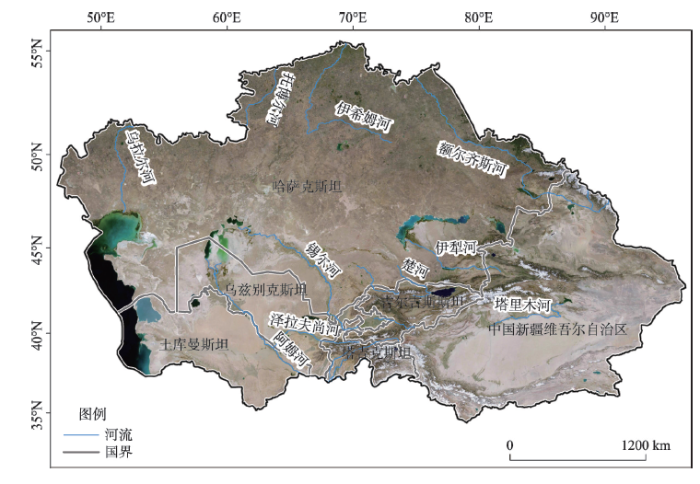 ��ʾԭͼ|����ԭͼZIP|����PPT
ͼ1���ǵ�����Χ����Ҫ����
-->Fig. 1Geographical boundary and major rivers of Central Asia
-->
���ǵ���λ�ڶ����������������������,������������ᡢ���ú��Ļ������Ľڵ�,��ʷ����ó�ۼ�,�ǹ�˿��֮·����Ҫ�ض�;�ڶ��������ս������,���ǵ�����һ����չ��Ϊ��Ҫ����Դ���ء�1991��ǰ���������,�����˹�����̶���,�����ƶȺ������Ʒ����ޱ�,�Ӿ�����һ������Ե���εĸ��ӳ̶�,���ǵ�����Ϊȫ���������������������е���,�ǹ����������ȶ��ĵ���֮һ[1]��
���ǵ������,�����ڶ�,��Ҫ�����а�ķ�ӡ������ӡ����ӡ�����˹�ӡ������˹�ӡ�����ӡ���ϣķ�ӡ��в����ӡ�����ľ�ӡ��������ӡ����ӡ��ߺ�ʲ�ӡ��������кӡ��ƶ���ɺӺͿ����ӵ�15��,�Ҷ�Ϊ���ʺ���������,�������ǵ����ش�ŷ�Ǵ�½����,��ˮϡ��,��������,����ˮ��Դʮ���ѷ�����60����,���Ǹ���ˮ��Դ���þ����˴Ӻ����������Ĺ��̣�ǰ����ʱ��,���ǵ�����20����60�����ʼ���ģ�˽�ˮ������;20����70-80����ﵽ�߷�,�����Ĵ�ӡ������������,�н�Ϊ������ˮ��Դ��������滮�벼��,Ҳ�нϺõ�ͳһ����;��1991���,����ǰ��������,�Թ�����Ϊ����ļƻ�����ת����˽����Ϊ������г�����,����־ޱ�,��ȫ�ݻ���ԭ��ˮ��Դ������ϵ��ͬʱ���ڽ���������仯,����֮����ˮ���������,���ǵ������������ι���ˮ�����ι���ˮ��ˮ��Դ����������ˮ��Դ�������ӡ���ҵ������ũҵ��ȡ���Դ�۸���ˮ��Դ�۸�,�Լ�ˮ��Ⱦ��ˮ�������������ì��,������һϵ��ˮ��Դ��ˮ��������,����Σ��������ȶ��뾭�÷�չ�����DZ���Ϊ�������ߴ�ˮ��Դ���˸߷���֮һ,�ǹ�����ˮ����ʮ�����صĵ�����
��ǰ,������ʮ�ֹ�ע���ǵ���ˮ�����о�,Unger-Shayesteh��[2]�ܽ�������仯�����Ǹ�ɽ����ˮѭ��Ӱ����о��ɹ�;Abdolvand��[3]�ӵ�Ե���νǶ����������ǵ���ˮ��Դ���õĺ����뷢չ;Abdullaev��[4]���������ǵ���ˮ��Դ���õı仯����;Karthe��[1]������δ�����ǵ���ˮ��Դ�������ٵ���ս����Щ���������´Ӳ�ͬ�����ܽ������ǵ���ˮ�����о��ɹ�,����ȱ���ӷ�չ���̡��о��������о����ݵȷ�����ۺϷ�����Ϊ��,���IJ�����2000��������15�����Ӣ������,�����������仯���о��������о�����,�Լ���Ҫˮ�����о��ȷ���,���ɹ������й����ǵ���ˮ�������Ҫ�о��ɹ�,�������ǵ���ˮ�����о��ȵ㡢�о������뷽��,��ʾ�о���չ�����ơ�
2 ����ͳ�Ʒ���
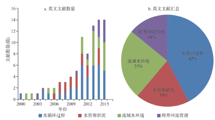
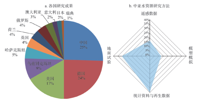
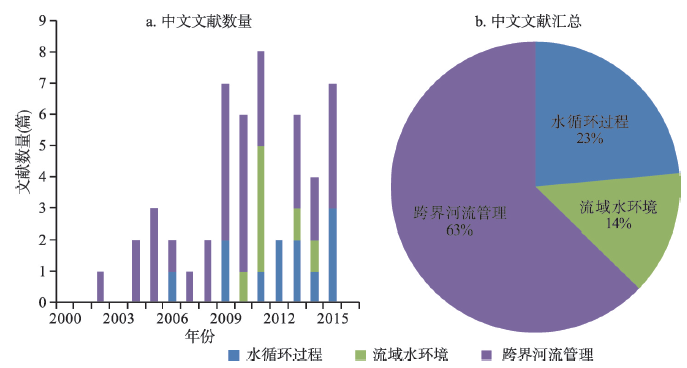
������ʱ�䷶ΧΪ2000��1��-2016��5�¡�Ӣ��������Ҫ��Academic Search Premier��ASP����ScienceDirect��Elsevier����SpringerLink��Kluwer Online�������ݿ��в�ѯ,��������ʽ�Ա����ؼ��ʡ�Central Asia+water������Central Asia+river����Central Asia+basin����ѯ;����������Ҫ�������ݿ��ѯ,��������ʽ�Ա����ؼ��ʡ�����+ˮ����������+�ӡ�������+����ѯ�����Ƽ���Ӣ������160ƪ,��������60��ƪ,�����������ǵ���ˮ����������ص�105ƪӢ������51ƪ����������ͳ�Ʒ���,��ѡ��60��ƪ�ص��������������������ǵ���ˮ������ص�,�ο�������ˮ��ˮ��Դ�о�����Ҫ����,���ÿƪ�����о�����,��ˮѭ�����̡�ˮ��Դ״��������ˮ�����Ϳ���������4���о�������з���ͳ��,ÿ�������漰���ǵ���ˮ����IJ�ͬ���ݣ���1��;ͬʱ����Ӣ���������������������о��������о��������ڹ��ҵȶ����ֱ�ͳ�ƣ�ͼ2,ͼ3,ͼ4����
Tab. 1
��1
��1��15�����ǵ���ˮ���������о�����ͳ��
Tab. 1Classification of research subjects of literatures on water issues in Central Asia during the last 15 years
| ����� | ����� |
|---|---|
| ˮѭ������ | ˮѭ��Ҫ�ء�ˮѭ�����̡���ѩ���ǡ�������Ǩ���������� |
| ˮ��Դ״�� | ˮ��ԴҪ�ء�����ˮ���̡�ˮ��Դ����ˮ��̬��ˮ��Ⱦ |
| ����ˮ���� | ˮ�ĵ���Ҫ�ء�������ᾭ�����ӡ����ظ������������� |
| ���������� | ��Ե���Ρ����ʹ�ϵ��ˮ��Դս�ԡ�ˮ��Դ���� |
�´��ڴ�
 ��ʾԭͼ|����ԭͼZIP|����PPT
ͼ2��15������ˮ����Ӣ������ͳ�ƽ��
-->Fig. 2Statistics of English literatures on water issues in Central Asia during the last 15 years
-->
 ��ʾԭͼ|����ԭͼZIP|����PPT
ͼ3��15������ˮ��������о��ɹ����о�����
-->Fig. 3Research achievements in some countries and methodologies of water issues in Central Asia during the last 15 years
-->
 ��ʾԭͼ|����ԭͼZIP|����PPT
ͼ4��15������ˮ������������ͳ�ƽ��
-->Fig. 4Statistics of Chinese literatures on water issues in Central Asia during the last 15 years
-->
���ǵ���ˮ����һֱ�ܵ���ع��ҵ����й�ע,�ر���2007�����Ӣ�����������������ӣ�ͼ2a��,˵����2007����������ˮ�����о�ȡ��������չ������Щ�о��ɹ���,���ǵ���ˮѭ������һֱ����Ҫ���о�����,2007���Ժ�����ˮ�����ܵ������ϵĹ㷺��ע,��2010�������ǵ��������������о����нϴ���������Ӣ��������ͳ�ƽ�����Կ�����ͼ2b��,���ǵ���ˮ������ˮѭ�����̡�ˮ��Դ״��������ˮ�����Ϳ���������4���������һ���ɹ�����,����������й�ˮѭ�����̵��о��ɹ����,ռȫ��Ӣ������42%;���Ϊ����ˮ�����о�,ռȫ��Ӣ������25%,ˮ��Դ״��������������о���Խ���,�ֱ�ռȫ��Ӣ������19%��14%��
��2000�����й����¹���������12�����ҵ�****�ڹ����ڿ��Ϸ��������ǵ���ˮ�����о��ɹ����Կ�����ͼ3a��,�С������������ijɹ����,�ֱ�ռӢ������������25%��24%,�����о��ɹ��ϼ�ռ����������һ��;����������Ͷ���˹�����ǵ������ҵ�****������Ӣ�ijɹ���Խ���,�ϼ�Ϊ20%���ҡ���ˮ������о�������,��Ҫ������ͳ���������������ݽ��з���,ռӢ������40%,����ͳ����Ҫ��Դ����������ͳ�Ʊ����������ܽ�,����������Ҫ��Դ�ڹ����Ϲ�����ң��ͬ������;Ӧ�õ���۲�͵���ʵ�����ݿ�չ�о�ռӢ������30%;ң�����ݵ�ʹ�������ǵ���ˮ�����о��бȽ��ձ�,ռӢ������18%;Ӧ��ˮѭ��ģ�͡�����ˮ��ģ�Ϳ�չ���о���������,��ռ12%��ͼ3b����
��Ӣ�����׳ɹ���ͬ����,�����й����ǵ���ˮ�����о��ɹ����ӵ�ʱ��ڵ�Ϊ2009�꣨ͼ4a��,��ӳ�����ڶ������ǵ���ˮ�����о����������������������йؿ������������о��ɹ��϶�,��2000������,�ò����о��ɹ�����ռ��������63%��ͼ4b��,���Ϊˮѭ�����̺�����ˮ�������о��ɹ�,����û�й���ˮ��Դ״�����о��ɹ����о�����������ͳ�Ʒ���Ϊ����
3 ˮѭ������
����仯��ˮѭ�����̵�Ӱ��һֱ�ǹ����о��ȵ�,����仯��ֱ��Ӱ����ɢ����������ˮѭ������,�Ӷ���������ˮ��Դ�ڿռ��ʱ���������ͷֲ�ģʽ�����仯�����ǵ����ش���½�ɺ���,������仯��Ӧʮ������,��15�������ǵ�����Ϊ��ʾȫ������仯��ˮѭ��Ӱ�����Ҫ����֮һ���й�ˮѭ�����̵��о���Ҫ�����������뽵ˮָ��仯��������,���±仯�Ը�ɽ������������,�Լ�ˮѭ�����̱仯�ԺӴ������ͺ����仯Ӱ��ȷ��档3.1 �����뽵ˮ�仯
�����뽵ˮ������仯�ı�־��ָ��,���߶�ˮѭ�������з����Եĵ�������,�о����߱仯���������ڷ�������仯��ˮѭ�����̵�Ӱ�졣Chen��[5]���������������Ľ�ˮ�ռ����ݷ�����1930-2009�����ǵ�����ˮ�仯����,������������绷��������,���ǵ�����ˮ��������,����������1970�����������;��������[6]ͨ���̺�������й��½�������������ˮ����̬ͳ������,�����˽�80�������ǵ�������仯̬��,��Ϊ���������ɡ�ů�ɡ���ůʪ������չ;Manning��[7]���ø߷ֱ�����������ģʽREMO���������ǵ�������仯,Ԥ������21����ĩ���ǵ�������仯����,�����������ǵ���������δ��100���н�����7 �档
��������,���ǵ�����60��������仯����Ϊ�������ߡ���ˮ����,��ȫ������仯ͬ������ͬʱ���ǵ���������������,IPCC�������������ָ��,��21����ĩ��RCP 8.5�����ȫ��ر��¶Ƚ�����2.6~4.8 ��[8],����Manning��[7]�ļ�����,���ǵ������������������Ը���ȫ��ƽ��ˮƽ,����仯��ˮѭ�����̵�Ӱ�������ǵ������ܷŴ�,����о����ǵ���ˮ��ѭ��������仯����Ӧ������Ҫ���塣
3.2 ��������
���������ǵ�����Ҫ�ĵر�������Դ,�����仯����������ˮѭ��Ӱ�������仯���±����ڻ��ٶȼӿ�,��������ʮ�����ԡ�Niederer��[9]���о��������,��1963-2000���ڼ�������˹̹������ɽɽ���������������˽�28%,�������ٶ���20����80��������Լӿ�;Li��[10]�����˽�50�����й���³ľ��һ�ű����۲�����,����1985���1996�����������������,��1996����������������Դ���1985��;Krigel��[11]����1970s��1990s���ڡ�2000s����MSS��TM��ETM+ң�������Լ�2007��SPOTң��Ӱ��,��������ɽ������������״��,�����ʾ����40���ʱ���ڱ���������23%;Hagg��[12]Ӧ��WGI��World Glacier Inventory����GLIMS��Global Land Ice Measurements from Space��ģ�������ǵ��������������,���������2050��,���½�����2.2~3.1 ��C,����������36%~45%��
�����о�����,��������������ǵ���������������,�������֮һ�ı�����ʧ,�����Ź�ҵ�����̼ӿ���������ʼ���̬��,�������ǵ���ˮѭ���ɳ�����չ��Ϊ������ͬʱ������Ϊ���ǵ����ر���������Ҫ��Դ,�����������¸õ����ر���������,�Ӷ�Ӱ�����;��÷�չ��ˮ��Դ���ϡ�
3.3 ���������仯
������仯���������Ӱ��,ˮѭ�����̱仯�Ʊ����������ں�����������Ӧ�ı䡣����������ˮѭ���IJ�����,�Ӵ�����������ˮ���ܵ�ˮѭ������Ӱ��,ͬʱ�Ӵ�����������ˮ��Ҳ���ˮѭ�����̲���Ӱ��Deng��[13]Ӧ�ó�ʱ�����������ˮ�Ĺ۲����Ϸ�����ˮѭ�����̶�����仯����Ӧ,������������ڹ�ȥ50���н�ˮ����,�������������߶�ˮѭ�����̵�Ӱ�������,��ѩ���������Ծ������ٵ����ø�����;Aizen��[14]Ӧ��ˮѭ��ģ�ͷ���������仯����ɽ����ˮѭ�����̵�Ӱ��,��������������ߵ�����ɢ������,��2100��ʱ��ɢ��������83%~87%;����仯�Ծ����ʷ�����Ӱ��,������˼���17%~13%;White��[15]Ӧ��ˮ��ƽ��ģ�ͷ���������仯�������ﺣ����ĺ���ˮ�ı仯,���������2070-2099����Ȼ��ˮ�������,���������½�����5 ��C,��������˼���10%~20%;Morris��[16]�ڼ�����˹˹̹����ˮ�������о���Ҳ���ֽ�ˮ�Ե���ˮˮ����������û�����á�
�Ӵ������ļ�����һ���̶��ϼӾ��˺���ή�����������[17]����3��ʱ��MODIS����,���üල������˹����뷽����ȡ���ǵ���ˮ��仯��Ϣ,���������ˮ��������ˮ�����Լ���ˮ�������Լ���;Bai��[18]Ӧ��1975�ꡢ1990�ꡢ1999�����ң�����ݽ��з���,�������1975-2007��������������49.62%;�������[19]������2003-2009������ǵ���24�����ͺ�����ˮλ�仯,��Ϊ������ˮ�Ը�ɽ��պ����ļ�������Ҫ����;Klein��[20]����AVHRR��MODISң�����ݷ�����1986-2012�����ǵ�����½ˮ�巶Χ,Ҳ�����˺���ή�������ơ�
���ºͽ�ˮ��ˮѭ�������е�������,���ҳʷ����Թ�ϵ�����ܽ�ˮ��������,����ˮѭ���Ĺ�������,�����ֲ���������ȱ�ڡ���������ʹ��ɢ������,���ºӴ���������,������ʹ���������ˮ������,����ˮ���С��
2012�ꡰ������̬ϵͳ��ˮ��ϵͳ������仯����������/�����仯����Ӧ�����ʻ�����,������ѧ�ҵ�һ�ζ�������̬�����仯��������Ӧ�������������,˵�����ǵ�������仯��ˮѭ�����̵�Ӱ���д���̽����,���һ���о���ʾˮѭ�����̵ı仯���ơ�ͬʱ,�������ǵ����µ������ӿռ������Դ�,ˮѭ��ʱ�ձ仯�dz�����,��ɽ��ѩ���ɿ��۲������ѷ�,�Լ��о�����ȱ��������,���ǵ���ˮѭ�����̵������о�Ҳ�ܵ�һ���̶���Լ��
4 ˮ��Դ״��
���ǵ������ε�ò�仯��,ˮ��Դʱ�շֲ�����,������仯��������Ӱ��,ˮ��Դ����ì�ܲ��ϼӾ�,���ǵ����ĵ�ˮ����Լ1.09��1012 m3����,�����������õ�ˮ��ԴԼΪ2.66��1011 m3,���еر�ˮԼΪ2.38��1011 m3,���ظ��ĵ���ˮԼΪ2.80��1010 m3 [21-22]����15���������ǵ���ˮ��Դ״�����о���Ҫ������½��ˮ�������Ӵ���������ũҵ������ȱ仯�������档4.1 ½��ˮ����
½��ˮ������һ�������ر�ˮ�����ˮ�ܵ�ˮ����,���������������ݣ�Gravity Recovery and Climate Experiment, GRACE����ȫ��½������ͬ��ϵͳ��Global Land Data Assimilation System, GLDAS�����ݼ��㡣Ŀǰ�����****Ӧ��GRACE�����������ݽ�������ˮ��������,��ʾ½�ش�ˮ���仯,���۵���ˮ��Դ״����Yang��[23]����GRACE�������ǵ���2003��1��-2013��3���³߶�½�ص�Чˮ��,�������½��ˮ������������ʺͼ����Բ���,������½�����,���������Ϊ0.42��0.12 cm;��ٻ��[24]����2003��1����2013��1��GRACE����,����TRMM��Tropical Rainfall Measuring Mission��/CMAP��Climate Prediction Center's Merged Analysis of Precipitation����ˮ���ݡ�NDVI��Normalized Difference Vegetation Index��ֲ��ָ����DEM��Digital Elevation Model���ȶ�������,���������ǵ���½��ˮ������̬�仯,����������ǵ����Զ�����½��ˮ�����仯�̶ȳ������ӵ�����,½��ˮ����������½�����,��������˹̹���ϲ��İͶ���ʲ�������ʳ����������ơ�
���ǵ������ɺ���½��,��Ȼ�õ���ˮ��Դ����������,���������õ�ˮ��Դ����Ϊˮ��Դ������24.4%,��Ӧ��GRACE�������ݵ��о��ɹ������õ���½��ˮ�����ʲ��ϼ�������,ˮ��Դ��ȱ״�������Ͼ���
4.2 �������仯
���ǵ����ܶ����ȱ��ˮ��վ�۲�,Ӧ��ˮ��ģ�ͼ���Ӵ������Ƿ����������仯����Ҫ;��,������ǵ���Ҳ�ǹ����Ͽ�չȱ��������ˮ��ģ��ʵ�����Ҫ����Cai��[25]��DTVGMģ��Ϊ����,��϶�Դ�ռ����ݣ�MS-spatial data��,�����˻��ڶ�Դ�ռ����ݵ�DTVGMģ�ͣ�MSDTVGM��,���������������������仯����,�����˶Գ���۲������;Radchenko��[26]Ӧ����gap filling��MODAWEC��Monthly to Daily Weather Converter���������������ȱ�ٵ�����,����������Щ������HBV-lightģ�ͼ��㾫�ȵ�Ӱ��;Wang��[27]���øĽ���SWATģ��ģ����1961-2007����ɽ����������������뾶���Ĺ�ϵ,�����˱����˻���ˮ�Ĺ��̵�����;Siegfried��[28]ͨ������仯����ѩ���Ǻͽ�ˮ�������ģ�ͽ�ʾ��������仯���µı�ѩ�ڻ��Ծ��������Ա仯��ֱ��Ӱ��;Ma��[29]��1961-1985��ˮ�����ϵĻ������ʶ���SWATģ��,��GCMs��Global Circulation Models�����ݽ��н��߶�,�������δ�����������³��Ӿ�����������1.0%~26.6%��
�ر�����������ȡ�����õ�ˮ��Դ֮һ,�Եر��������о�һֱ��ˮ��Դ�о��е��ص㡣���ǵ�������ȱ��ˮ�����ϵ���,Ӧ�ö�Դ����֧�ֵ�����ˮ��ģ����ģ����������仯�����ոõ���ˮ��Դ״������Ҫ;��,��Ϊ�õ���ˮ��Դ�����ṩ�ɿ���������Դ�����緶Χ��ˮ��ģ���ڶ�,����Ӧ�õ����ǵ�������Խ���,Ҳ��ӳ���Ըõ����ر��������о����ڷ�չ�Ρ�
4.3 �����ˮ
��������ǵ���ũҵ�����Ҫ�ֶΡ��õ���Լ8.0��106 hm2�ĸ�����������ڵر�ˮ���,�������������ķ�Ӻ������ӹ����ˮ��ռ��ȡˮ����90%[21, 30],�����ˮ�����ǵ�������Ҫ��ˮ��Դ���÷�ʽ��Ȼ�����ڹ�ˮ�������������ˮ����ʩ���е�Ч,ˮ��Դ��ľ�,������ũҵ�����ˮЧ���ǵ�ǰؽ����������⡣Kitamura[31]���������ǵ���ˮ��Դ���������ٵ�����,������ˮЭ�ᣨWUAs���ڹ��������ά������ˮ��ʩ,���ũҵ��ˮЧ�ʷ��淢������Ҫ����;Iskandar��[32]���������϶��µļ���ũ��ʽ���й�ȹ����ľ�����,��Ϊ������ˮ��С�飨WUGs����һ����Ч�Ĺ�����ʩ,�ܹ���Ч֧��WUAs��ʵʩ��
��WUAsũҵ�����ˮ����������,�����ɿ���ũҵ��ˮЧ�����۷���ʮ����Ҫ��Awan��[33]���������ɢ������RET�����������ܱȣ�DPR��������ϵ����DR���������ıȣ�OCR����������ñȣ�FAR���ʹ����ʣ�CR����Ϊָ��,������WUAs��ȹ�����Ч��;Karimov��[34]Ӧ�þ��ú��㷽������ũҵ��ˮDZ��,ͨ�����ζ���ӯ��ˮ�����ļ����·��乩������,����˹��Ч��;Platonov��[35]����Landsat ETM+��ʱ�������������ɹ�������ˮ��������ͼWPMs,��Ӧ�õ���ȹ�����;Pereira��[36]Ӧ��ISAREG���ģ��ģ��Ľ���Ĺ���ƶ�,������ƶ��������ϵ��������,��߹��Ч��20%;Conrad��[37]�����ڶ����ң�з������������Ϲ���ʳũҵ��֯��FAO�������CropWatģ�����,��ȡ�����Ͷ�С���ȵ�����ֲ�����ˮ���ݡ�
���ǵ���ũҵ��ֲ������ˮ���ȸߺ�ˮ����Ϊ��,��ǧ����ũҵ���һֱ�����ǵ���ˮ��Դ���õ���Ҫ��ʽ[38]����߹��ˮ����Ч��,���ƹ�ȼ��������ʩ,���������ȷ�����������ˮ,����ũҵ��ȵ����Ϲ�������,��ǿˮ��Դ����Ч������,������ˮ��Դ�ɳ�������������Ҫ��������ˮ�ġ��������ú�ˮ��Դ�ȷḻ����֧����,���������ˮ��ϵͳ�ı仯,�Լ���������ᾭ�õ�����úͷ�������,��δ�����ǵ���ˮ��Դ�����о��ķ�չ����[2]��
5 ����ˮ����
����仯�Ͳ��������������ºӴ��������١�����ˮ�ʶ�,�����˻�����Ӱ�쵽������̬ϵͳ������,Σ������ˮ��������15����,�������ǵ�������ˮ�������о���Ҫ������ֲ����̬�仯������仯����Ӧ���ơ�����Ҫ�ء��������ջ��������˻����˿ڡ���Դ��������ϵ������4�����档5.1 ֲ����������Ӧ����
ֲ�����������ܵ�����仯��Ӱ��,�ر������ǵ���λ����½�ɺ���,ֲ����Խ���,������仯�������С��о�ֲ����̬�仯������仯����Ӧ���ƶԽ�ʾ���ǻ������ݱ���̡�Ԥ�����չ���ơ�ά������ˮ����������Ҫ����,���ֲ���仯����Ϊ����ˮ�����ı�־������ϼ��[39]����1982-2002��NDVI���ݺ������о��飨CRU����ˮ���������ݷ���NDVI��ʡ����ڱ仯�������������ӵ���ع�ϵ,�������49%�ĵ������NDVI���꽵ˮ���������,52%�ĵ���NDVI�봺����ˮ�������,34%�ĵ���NDVI���ļ���ˮ�������;Gessner��[40]����1982-2006���NDVI������ˮ���ݣ�GPCC Full Data Reanalysis��������ֲ�������Խ�ˮ�仯��������,���ֽ�ˮ�쳣�����ǵ���ֲ��״��Ӱ��̶Ƚӽ�80%;������[41]�����ǵ���1982-2012��ֲ���仯������仯����Ӧ�о�����,NDVI�Ŀռ�仯�����뽵ˮ�Ŀռ�仯������Ϊһ��;Kariyeva��[42]Ӧ��1981-2008��ң��ֲ���̶����ݷ��������ǵ���ֲ�����������̬�Ĺ�ϵ,�����������������Ӧ�����뽵ˮ�������,����������ʹֲ����������ǰ,�������ӳ���
����仯��ֲ����Ӱ����и��ӻ���,��ˮ��������Ϊ��ֱ�ӵ�����仯���Ӷ�ֲ����̬����ʮ�����ԡ���Ŀǰ�о�������Կ�����ˮ���������ڿռ���ֲ�����Ƕȵ����,���������ӳ�������ֲ������ʱ��,�����ڸ�����ֲ����������Ӧ���Ƶ��о���Ȼȱ����
5.2 ����Ҫ��
����Ҫ���������ݱ䷢չ�Ļ���,�����Ĺ����в��ɱ���Ի���Ҫ�ؽ��и��졢�ƻ�,�Ի���Ҫ�ص��о����˽�ˮ������״��Ԥ��ˮ������չ�Ļ�ʯ�����۸��Ӱ��������������ƽ�������ѭ������,ֲ����ϵ��ˮ��ӳ������ֲ������״��,����ˮ����ֲ������,��ũҵ��ı�Ҫ������Luo��[43-44]Ӧ��Cellular Automata��CA��-Markovģ�ͷ����˹�����˹̹������������۸��ʱ�ն�̬,����������������ˮ�������ܸ�������,ˮ�����̶��������۽ṹ�仯������Ϊ��Զ;Li��[45]����ͨ��½��ģ��CLM����ֲ����ϵ��ˮ����,ģ��ֲ���Ըɺ���������Ӧ,��ȡ�����ǻ�Į��̬ϵͳ��ˮ��ͨ������;Devkota��[46]�������ȱ��˹̹2008-2010��ˮ����С����������ʵ������,����CSM-CERES-Wheatģ�ͼ������������������������������ˮ���仯;��������[47]��2003-2010�����ǵر�����ˮ���о��������,���ǵ���ֲ���������������ļ��ر�����ˮ���Ա��Ϊ����
ֲ����̬�仯ʹ���۸�֡���ϵ��ˮ������ˮ�Ȼ���Ҫ����֮�仯,��һ���̶���������ˮ�ֵ����ġ���Ȼ��****�Ѿ������ǵ�������Ҫ��չ���о�,��Ŀǰ���ڸ�����Ҫ�ص��о����Ա���,�в���Ϊ����ˮ���������ṩ��ֵ�����ָ����
5.3 �������ջ�
ũҵ����������Ĵ�ͳ������ҵ,��һ����һ�����ܵ�����������Ȼ��ԴӰ��,��һ�������ǵ���ũҵ��ǰ����ʱ���������ƻ����õ�һ����Ҫ��ɲ���[48]��ũҵ��д���ʩ��ũҩ�����Լ��������Ĺ�ȷ�ʽ��������������ջ�,������в���ǵ���������ˮ������Devkota��[46]��ˮ����С��ũҵ���ʵ��Ϊ����,���������ܶGMs�����������/�ɱ��ʣ�BCR������ũҵ������������ջ�������������;Karimov��[49]��HYDRUS-1Dģ���о�dz�����ˮλ��Ӱ��,ģ������������ˮλ������ȼ���,����ˮ����ɢ����������,�����ϵ���η��ۻ��Ӿ�;Chen��[50]�ӿ�ȸ�Ӳɼ���14���ر�ˮ��9�������������Ʒ,������������о���������л���ũҩ;Crosa��[51]��ķ������ˮ�ʽ��в�����������ũҵ������������˴������ջ�����,���°�ķ������������ˮ�ܵ�Ӱ�졣
������ᾭ�÷�չ������,��������ũҵ���û���ܵ�����,�Ӿ����������ջ��̶�,�����˻������������,ũ�����������,������ʳΣ��;ũҩ����ʩ��Σ������ˮ����;�Ͷ�����ˮ��Դ����Դ��ȱ����������ɱ�,�Դ�ͳ���������ʽ������µ���ս����Χ���������ջ���������������������в,���,�����������ء���ǿ���ջ���������������ˮ�ʵĹ����̲��ݻ�,�����ǵ����������ջ��γɵ����ԭ��Ӧ�ܵ����ӡ�
5.4 �˿ڡ���Դ��������ϵ����
ά��һ�������Ŀɳ�����չ��Ҫ�ۺ�Э�����˿ڡ���Դ������֮��Ĺ�ϵ���˿����������Ӵ���Դ�ͻ�����ѹ��,�����˿�����Դ�������Ĺ�ϵ�����ھ�������ȶ���չ��Schl��ter��[52]�������̺�ή�����ˮ��ȵ����,��ΪӦ�����������������������ϵ��,�����ʪ����̬ϵͳ����Ĺ�������,������ᡪ��̬ϵͳ�Ļָ���;Cretaux��[53]��ǧ��߶��Ϸ����̺�ˮλ�仯���Ⱥ�ԭ��,��������˿ڲ���������������̺���̬��ˮ����ˮ����;Djanibekov��[54]�����ȱ��˹̹Ϊ��,�о������ǵ����˿���ʳ��ˮ�㼣�仯,����������2034��ʱʳƷ���ѹ��ҵ�ˮ�㼣;Bekchanov��[55]���þ�������ģ���������ȱ��˹̹��ˮ���ٶ����徭�õ�Ӱ��,�����������ˮ����10%~20%,�����ٹ��24.1~37.4��hm2������,����71.2~86.8���˿�ʧҵ,����������ʧ3.6%~4.3%��
������������ʼ,����ũҵ���ǽ����ں�������ˮ��Դ�Ļ�����,��һ���Ծ�ά������ˮ��������Ч��ʽ�����ǵ������ŷ���ijɹ�����,��ȫ�¼�������ɽɽ´����������ڲ��ϸı��������ʽ,�Ծ�ά��������̬�����ɳ�����չ[56]����������������仯,ˮѭ�����̺�ˮ��Դ���䷢���䶯,����Ӿ��������ˮ����Ҳ������Ӱ�졣�������˿ڡ���Դ�������ĺ�г��ϵ,������Чˮ��Դ���÷�ʽ��ά�����ǵ���ˮ�����ĸ���;����
6 ����������
���ǵ����������ڶ�,ˮ��Դ�ռ�ֲ�����,����ì��ʮ��ͻ������������Դ�����ᵼ�¿�������������,�羳ˮ��Դ�ĺ����������á�Э�������Ϳ�������ά��,�븴�ӵĵ�Ե���Ρ����õ������Ӱ��,Խ��Խ�ܵ���ע[57]�������Ҫ����Ȼ��Դ������Ļ�����Ե���εȶ��ά����ȷ��������������ά�ȵĿ���������ʮ�ָ���,Stucki��[58]����ؽ�����ˮ��Դ���������ħ��,�������ǹ���,�������й���ŷ�˵�Ҳ��������,���в�ͬ���漯�ŵ�ʹ���ǵ����������������Ӹ��ӡ���ˮ��Դ��Ȼ�ֲ�״������,λ�����εļ�����˹˹̹��������˹̹����ӵ�����ǵ���90%��ˮ��Դ,��λ�����ε����ȱ��˹̹��������˹̹��������˹̹��������ˮ��Դ������������,���������ȱ��˹̹��������˹̹����90%��ˮ��Դ���Կ�����[59]��Ȼ�����ڹ�����������ǵ���ˮ��Դ����ì��ͻ��,��������ˮ��Դ��������ռ11.4%,���������ȱ��˹̹��������˹̹��������˹̹3������ˮ��Դʹ�����ֱ�ռ52%��20%��10%[60-61]��ˮ��Դ�ֲ������õIJ������Ǹõ���ì�����˵���Ҫԭ��,�������������ʳ�ͻ�Ŀ�����,Ϊ���������ҲŬ��Ѱ�ҽ������ij�·��
������������,�����������Ѱ�÷�չ,ˮ��Դ���õ�ì�ܱ����ϼ���,Χ�ƿ����������������������ҡ�Ϊȷ�����ǵ���ˮ��Դ��ʹ���뱣��,�����̺�����̬����,��������ֱ���1992���1993������ˡ�ˮ��Դ���Э��ίԱ�ᡱ�͡������̺����ʻ���ᡱ,������������������֯�������з���Լ����,���ڷ��ɲ�������Լ���Ǹ�����ˮ��Դ��������������,��˶������ǵ���ˮ��Դ�����������ޡ��������ڸ���ȱ������,���ι��������ι���ǩ����һϵ��ˮ��Դ������Э������û��Լ����,ˮ��Դ��������ʮ���ձ�[1]��
���ǵ������ҵĿ羳ˮ��Դ���������˹���ר��****�Ĺ㷺��ע,Χ�Ƹ�����չ����һϵ�����ۡ�Abdullaev��[4]�Ա������ȱ��˹̹ˮ��Դ��������ʷ����״,���������ͳ���������ˮ��Դ������ʽ����ɥʧ;Abbink��[62]���ò����۷��������ǵ��������������еĺ���������,����������ǵ�����Ҫ����߶ȵ��������,����������ʵ��;�γ�÷[59]�������Ǹ����½�ˮ��վ������о��ɹ�����,�������½�ˮ��վ�����ϵIJ�ͬ����,�γ��˶��������ɣ����ι�������Դ����,���ι�������ˮ������������ȱ���������ij���,ֻ���Լ���������������,���������������������ҵ�����,����������������,ˮ��Դ�����ǵ�����Ϊ���ι��ߺ�̸�г��롣
ˮ��Դ�ǹ�����Ȼ��Դ����ɲ���,��������ˮ�ġ���ᡪ�����Э���Ĺ���������ȷ��������ˮ��ȫ����Ҫǰ�ᡣSeidakhmetov��[63]��Ϊˮ��Դ�����ǻ�������ɲ���,�����ǵ��Ȼ��Ƶ���Ҫ��ɲ���,Ӧȷ�����ǵķ��ɻ������������ݺͼ���֧��;Sorg��[64]����������ˮ�ġ���ᡪ���η�չ��������ˮ�������Ӱ��,�����Ӧ��ˮ��Դ�仯�����˴�ʩ;Abdolvand��[3]��Ϊ���ǿ�������������Դ�����ν��ܹ���,�õ���ˮ������Դ�����ḻ,����Щ��Դ��η���һֱ�Ǹ�����ִ��ԭ��,�����˽��ŵĹ��ʹ�ϵ;Abdullaev��[65]�о��ɹ��������ǹ��Ҿ������߹�ע�������������Դ���ɶ������������Ч��,����ˮ��Դ������Ȼ����Щ����ˮ��Դ����ռ������λ,�����ƶ����Դ�ˮ����Դ��ũҵ������仯ϵͳʵ�ֻ�����Ӯ��
��2000������,�й����ǵ���ˮ����Ĺ��ʻ���ƵƵ�ٿ�,��2009-2016����еĹ��ʻ���Ͷ��ʮ��Ρ���ǿ��������,��Ч���������õ���ˮ��Դ�ǽ�15��������ˮ����һ�ɲ�������⡣Karaye��2010�ꡰ����֮ˮ�����ʻ�����ָ��,���ǵ������ڵ�������ⲻ��ȱˮ,���Ǹ�����Э�̲���ɹ�ʶ������������ڲ�ˮ����ˮ�ռ�ֲ������,������ˮ��ϵ����,�����������治ͬ,����ǿ�������Ա�����ɵ���ʧ,�Ӵ���ˮ��Դ�����Ѷ�[57],���ҵĹ�������ˮ��Դ����ʮ�ִַ�,Ч�ʵ���[66]��ÿһ�����Ҷ���ͼͨ�����ϱ�����Դ����Դ�Ķ�����,�Ӷ��������Ե���ε�λ�����,���ǵ���������������Խ�����ǵ����߽�,��Ϊ����������,ֻ�д�ȫ���Ե��������Ƕȳ���,����ȫ����Ч�ؽ���øõ����������������⡣
7 ����
ͨ�����϶����ķ������Եó����½��ۣ���1�����ǵ���ˮ�����о��ǵ���ѧ���о��ȵ�֮һ��2007���������ǵ���ˮ�����ܵ�������㷺��ע,�й����¹��������ȹ��ҵ��о�****��չ�˴����о�����,ȡ��һϵ�гɹ�,�о�������Ҫ������ˮѭ�����̶�����仯����Ӧ������ˮ����������,�й��ڿ������������о��ɹ���Էḻ;�о�������Ҫ������ͳ���������������ݽ��з���,ң������Ҳ�н�Ϊ�㷺��Ӧ�á�
��2�����ǵ���ˮѭ��������������仯Ӱ��,½��ˮ������Ӵ�������С�������ԡ����ǵ������ڸɺ�������,�ش�ŷ�Ǵ�½��½����,����仯��ˮѭ�����̵�Ӱ��ʮ������,���������뽵ˮ����������仯�Ļ�������,���������ߵ�ЧӦ����,���±�������,��ɢ������,�Ӷ�����Ӵ��������������ή��,ˮ��Դ״������һ����
��3������仯��������в�����ǵ�������ˮ���������������ӳ���ֲ��������,�ı���ֲ�����۸��,��һ���̶���������ˮ�ֵ�����;��������ũҵ���,�Ӿ����������ջ�,�����˻������������;ũҩ����ʩ�ü�����ˮ������Ⱦ;�Ͷ�����ˮ��Դ����Դ��ȱ����������ɱ�,�Ӵ�������ˮ������ѹ����
��4�����ǵ��������������ǵ�ǰ����������ٵ��ش���ս��ǰ�����Ľ���,��ȫ�ݻ���ԭ��ˮ��Դ������ϵ,��֮����������仯,����֮����ˮ���������,������һϵ����̬����,����Σ��������ȶ��뾭�÷�չ,���ǹ��ҡ��������й���ŷ�˵��Լ���ͬ���漯�ż���ʹ���ǵ���������������Ϊ���ӵĵ�Ե�������⡣
�Խ�15����о��ɹ���������,��ǿ���ݻ�ȡ,���ӵ���۲�,�ر��Ǹ�ɽ��ѩ���������������������ǵ���ˮѭ�����̻���;�ڷḻ����֧����,���������ˮ��ϵͳ�仯,�Լ���������ᾭ�õ����������,��δ�����ǵ���ˮ�����о��ķ�չ����;Э�����˿ڡ���Դ���������ϵ,������Чˮ��Դ���÷�ʽ��ά�����ǵ�������ˮ�����ĸ���;��;��ȫ���Ե���νǶ�,������ˮ�ġ���ᡪ���ο�ܻ����Ͽ�չ�о�����ȫ�����øõ����������������⡣
The authors have declared that no competing interests exist.
�ο����� ԭ��˳��
������ȵ���
������������
�����ڿ�Ӱ������
| [1] | Large parts of Central Asia are characterized by a semiarid to arid climate. Therefore, areas close to shallow groundwater, rivers and lakes are characterized by unique water-dependent ecosystems and human societies which have developed over millennia in close interaction with the naturally limited water resources. In the early 21st century, global climate change, population growth, river damming, large-scale water abstractions and rising levels of pollution exert multiple pressures on the region��s water resources, aquatic and terrestrial ecosystems at historically high levels. Water scarcity threatens the livelihood of populations locally and in transboundary settings by a growing competition over a limited resource. This context is of particular importance since all major rivers of the region cross at least one international border. The complexity and character of water-related challenges in the region mean that management approaches need to be integrative, taking into account the natural resource basis, environmental limits and the socio-cultural and geopolitical dimension. This paper frames the thematic issue of Environmental Earth Sciences and provides a comprehensive overview about the current state of knowledge about water resources and their management in Central Asia. There is a focus on case studies looking at the Selenga�CBaikal�CAngara Basin, the Lake Aral Basin including the Syr Darya and Amu Darya river systems, the Tarim and the Illi River Basins. Aiming to be an up-to-date interdisciplinary scientific reference on the region��s water-related challenges, this thematic issue gives theoretical and practical insights into solutions and best practice examples of water management. |
| [2] | The MeOH extracts were separated by Sephadex LH-20 column chromatography; 22 and 19 fractions were obtained from A. macrophylla and A. stricta respectively . The fractions with different TLC profiles were tested for their antioxidant activity, evaluated as removal of the stable radical DPPH, total antioxidant capacity based upon the reduction of Cu ++ to Cu + and lipid peroxidation. Subsequently, the active fractions were purified using HPLC, and 4 active compounds could be isolated (Chlorogenic acid isomers, Rutin, Luteolin-7-O-glucoside, Apigenin-7-O-glucoside). |
| [3] | Central Asian water management has always been linked to energy and security politics. The region is abundant in water as well as in natural energy sources. However, distribution of these resources is a steady reason for quarrel within the region. In particular, the usage of mutually shared waterways creates tensions between different nation states. The five Central Asian republics Kazakhstan, Uzbekistan, Turkmenistan, Tajikistan and Kyrgyzstan seek energy independence and try to consolidate their position within this geopolitically important region. Despite their complex interdependencies, which affect all important social, economic, political and security relevant matters, Central Asian national states have initiated a disintegration process in the region. Economic crises after decades of mutual dependence make the region dependent on foreign investments. Within this complex setting, managing transboundary waters becomes a sensitive task that seems impossible to be resolved by the affected players themselves. Central Asian water management reaches beyond the borders of the region and has long become an international concern. This article analyzes how foreign geopolitical interests shape regional water management, and how capacity building measures can lead to sustainable management from within the region. |
| [4] | ABSTRACT This paper presents the analysis of historical transformation of water management in Central Asia with the specific focus on Uzbekistan. The time frame of the analysis is from the Middle Ages to contemporary times, with different political, social and economic settings in the framework of theory of transformative capacity of institutions. Empirical evidence suggests that the approach of the hydraulic mission has not changed dramatically over the years, but transformed into various forms of control on water management. In recent decades, integrated water resources management paradigms are gaining momentum, while the traditional, State-centric, hydraulic mission approach is losing its attractiveness in the arid Central Asian region. Nevertheless, the State-centric model of water management still persists in the region with clear signs that water management is still more under socio-political control. |
| [5] | This study analyzed the temporal precipitation variations in the arid Central Asia (ACA) and their regional differences during 1930-2009 using monthly gridded precipitation from the Climatic Research Unit (CRU). Our results showed that the annual precipitation in this westerly circulation dominated arid region is generally increasing during the past 80 years, with an apparent increasing trend (0.7 mm/10 a) in winter. The precipitation variations in ACA also differ regionally, which can be divided into five distinct subregions (I West Kazakhstan region, II East Kazakhstan region, III Central Asia Plains region, IV Kyrgyzstan region, and V Iran Plateau region). The annual precipitation falls fairly even on all seasons in the two northern subregions (regions I and II, approximately north of 45°N), whereas the annual precipitation is falling mainly on winter and spring (accounting for up to 80% of the annual total precipitation) in the three southern subregions. The annual precipitation is increasing on all subregions except the southwestern ACA (subregion V) during the past 80 years. A significant increase in precipitation appeared in subregions I and III. The long-term trends in annual precipitation in all subregions are determined mainly by trends in winter precipitation. Additionally, the precipitation in ACA has significant interannual variations. The 2-3-year cycle is identified in all subregions, while the 5-6-year cycle is also found in the three southern subregions. Besides the inter-annual variations, there were 3-4 episodic precipitation variations in all subregions, with the latest episodic change that started in the midto late 1970s. The precipitations in most of the study regions are fast increasing since the late 1970s. Overall, the responses of ACA precipitation to global warming are complicated. The variations of westerly circulation are likely the major factors that influence the precipitation variations in the study region. |
| [6] | �����̺�����ش�ȫ������仯���������ģ���̬����������ˮ��Դ��ȱ����ȥ�����������̺�����������������̬�����������˽�Ϊ�����ı仯�����������̺���������-ˮ-��̬-�����Ĺ�ϵ������Ȼ������������½��ɳ�����չ������Ҫ�Ľ�����塣�������ռ�������Ϊ�������Ա��о���50 a���½�����80 a�������̺���������¡���ˮ����Ҫ�����ľ����仯�������϶���ˮ��Դ�������õ��ݱ����̣���������仯���������о�����̬�����������չ��Ӱ�죬����������̺���������仯����������̬�������ۺϹ�ϵ����������仯���½�ˮ��Դ�������õ���Ӧ�ԶԲߡ������������80 a�����½��������̺�����������ֽ�Ϊһ�µı�ů���ƣ�������20����80������������߾��ֵ����������“ů��”��“ůʪ”ת�ͼ��Ӵ�����Ҳ�в�ͬ�̶ȵ����ӣ�������������ģ��ǿ�ȵ�Ѹ�١�������ǿ���о�����̬����������δ�õ���Ч���ƵĶ����ơ�����������������ʱ�ڣ�ǿ��ˮ��Դ�������ù��������ˮ��Դ����Ч�ʺ�Ч�棬�ӿ�ؼ�ˮԴ���̽��裬����ˮ��Դ����������ϵ�Ľ��裬��δ��һ��ʱ����Ӧ������仯���½�ˮ��Դ�������õ���Ҫ��Ӧ�ԶԲߡ� . �����̺�����ش�ȫ������仯���������ģ���̬����������ˮ��Դ��ȱ����ȥ�����������̺�����������������̬�����������˽�Ϊ�����ı仯�����������̺���������-ˮ-��̬-�����Ĺ�ϵ������Ȼ������������½��ɳ�����չ������Ҫ�Ľ�����塣�������ռ�������Ϊ�������Ա��о���50 a���½�����80 a�������̺���������¡���ˮ����Ҫ�����ľ����仯�������϶���ˮ��Դ�������õ��ݱ����̣���������仯���������о�����̬�����������չ��Ӱ�죬����������̺���������仯����������̬�������ۺϹ�ϵ����������仯���½�ˮ��Դ�������õ���Ӧ�ԶԲߡ������������80 a�����½��������̺�����������ֽ�Ϊһ�µı�ů���ƣ�������20����80������������߾��ֵ����������“ů��”��“ůʪ”ת�ͼ��Ӵ�����Ҳ�в�ͬ�̶ȵ����ӣ�������������ģ��ǿ�ȵ�Ѹ�١�������ǿ���о�����̬����������δ�õ���Ч���ƵĶ����ơ�����������������ʱ�ڣ�ǿ��ˮ��Դ�������ù��������ˮ��Դ����Ч�ʺ�Ч�棬�ӿ�ؼ�ˮԴ���̽��裬����ˮ��Դ����������ϵ�Ľ��裬��δ��һ��ʱ����Ӧ������仯���½�ˮ��Դ�������õ���Ҫ��Ӧ�ԶԲߡ� |
| [7] | The high-resolution regional climate model (RCM) REMO has been implemented over the region of Central Asia, including western China. A model run forced by reanalysis data (1/2 degrees resolution), and two runs forced by a GCM (one run with 1/2 degrees and one run with 1/6 degrees resolution) have been realized. The model has been evaluated regarding its ability to simulate the mean climate of the period 1971-2000. It has been found that the spatial pattern of mean temperature and precipitation is simulated well by REMO. The REMO simulations are often closer to observational data than reanalysis data are, and show considerably higher spatial detail. The GCM-forced simulations extend to the year 2100 under the A1B scenario. The climate change signal of temperature is largest in winter in the northern part of the study area and over mountainous terrain. A warming up to 7 C is projected until the end of the 21st century. In summer, warming is strongest over the southern part of Central Asia. Changes in precipitation are spatially more heterogeneous. (C) 2013 Elsevier B.V. All rights reserved. |
| [8] | |
| [9] | <a name="Abs1"></a>The status and dynamics of glaciers are crucial for agriculture in semiarid parts of Central Asia, since river flow is characterized by major runoff in spring and summer, supplied by glacier- and snowmelt. Ideally, this coincides with the critical period of water demand for irrigation. The present study shows a clear trend in glacier retreat between 1963 and 2000 in the Sokoluk watershed, a catchment of the Northern Tien Shan mountain range in Kyrgyzstan. The overall area loss of 28% observed for the period 1963–2000, and a clear acceleration of wastage since the 1980s, correlate with the results of previous studies in other regions of the Tien Shan as well as the Alps. In particular, glaciers smaller than 0.5 km<sup>2</sup> have exhibited this phenomenon most starkly. While they registered a medium decrease of only 9.1% for 1963–1986, they lost 41.5% of their surface area between 1986 and 2000. Furthermore, a general increase in the minimum glacier elevation of 78 m has been observed over the last three decades. This corresponds to about one-third of the entire retreat of the minimum glacier elevation in the Northern Tien Shan since the Little Ice Age maximum. |
| [10] | Similar to most mountain glaciers in the world, Urumqi Glacier No. 1 (UG1), the best observed glacier in China with continued glaciological and climatological monitoring records of longer than 50 years has experienced an accelerated recession during the past several decades. The purpose of this study is to investigate the acceleration of recession. By taking UG1 as an example, we analyze the generic mechanisms of acceleration of shrinkage of continental mountain glaciers. The results indicate that the acceleration of mass loss of UG1 commenced first in 1985 and second in 1996 and that the latter was more vigorous. The air temperature rises during melting season, the ice temperature augment of the glacier and the albedo reduction on the glacier surface are considered responsible for the accelerated recession. In addition, the simulations of the accelerated shrinkage of UG1 are introduced in this article. |
| [11] | Glaciers are significant fresh water storages in Central Asian high mountains and are considered to substantially contribute to the summer runoff of Central Asian Rivers. We present a comprehensive study of the glacier area changes in the Naryn catchment located in the Tien Shan Mountains. The catchment with a size of 55,944 km(2) is a major tributary of the Syrdarya River which is heavily used for water supply and irrigation. We analysed the glacier retreat based on Landsat MSS, TM and ETM + imagery for the mid-1970s, late 1990s and mid-2000s and based on a SPOT scene for 2007. Our results show a decreasing glacierisation within the catchment, shrinking from 1210 +/- 30 km(2) (2.2% glacierisation) in the 1970s to 1019 +/- 25 km(2) (1.8% glacierisation) in the late 1990s and further down to 926 +/- 23 km(2) (1.7% glacierisation) in the mid-2000s, corresponding to an area loss of 23% in total. The analysis reveals spatially heterogeneous area loss within the catchment. This can be associated with different hypsometries, size distributions, aspects and presences of debris cover. Small glaciers (with an area <1 km(2)) suffered from a strong area loss within the 30-years investigation period.<br/>Trends in air temperature, precipitation and positive degree days (PDD) at climate stations suggest that the glacier retreat is likely to be driven by the increasing summer (April-September) temperature, rather than Changes in precipitation: In the period from 1960 to 2007, both summer air temperature and PDDs increased significantly at a rate of 0.19 degrees C/decade and 3.9 degrees C/decade respectively, whilst for precipitation no consistent trends were detected. However, rigorous attribution of changes is complicated by the variable glacier response times. In the two headwater sub-catchments of the Naryn basin, Small and Big Naryn, positive trends in spring and autumn discharge were detected and are likely to be associated with the enhanced snow and glacier melt driven by increasing temperatures in those seasons. However, no discharge trends in August the month with the largest expected glacier contribution - were detected. The strong, significantly positive trends in winter and early spring runoff are associated with strongly increasing winter temperatures and number of days with maximum daily temperature above the freezing point causing snow melt. Hence, increasing glacier area reduction can be explained by the prolongation of the melting season reducing accumulation rather than by increasing annual mean temperatures. Despite the high relative changes, the absolute increase in winter discharge is very small. (C) 2013 Elsevier B.V. All rights reserved. |
| [12] | A conceptual hydrological model was set up in the upper Panj catchment, the main tributary of Amu-Darya river. After a manual calibration procedure involving model runs with different restrictions, the model reproduced both daily hydrographs of Tanimas river at the Rukhk gauging station (NSE = 0.86) and the snow water equivalent of the Irkht station (R-2 = 0.85) in a very satisfactory way. Based on two glacier inventories from the mid-20th century (WGI, World Glacier Inventory) and from 2003 (GLIMS, Global Land Ice Measurements from Space), a simple parameterization scheme based on steady state conditions was applied to infer the ice volumes and glacier areas for these different time periods. Assuming temperature rises of 2.2 degrees C and 3.1 degrees C, which mark the extreme values of regional climate scenarios, the same method was used to extrapolate glacierization to the year 2050. The results show that these temperature rises will reduce the current glacier extent of 431 km(2) by 36% and 45%, respectively.<br/>To assess future changes in water availability, the hydrological model input was modified according to the regional climate scenarios and the resulting glacier changes. The use of an elevation distributed deglacierization pattern is a clear improvement over methods used previously, where the impact on runoff was tested by excluding either the lower half or the total glacier area. The runoff scenarios reveal only a slight reduction in annual runoff, because the glacier area decrease is almost balanced out by enhanced melt rates. However, there is an important seasonal shift of water resources from summer to spring, unfavorably affecting agriculture and irrigation in the lowlands. (C) 2013 Elsevier B.V. All rights reserved. |
| [13] | Climate change in complex mountain regions has an impact on the change of water resources, especially in arid areas. Here, we use long-term meteorological and hydrological station observation data to analyze the time series of climate indices and runoff to study the variability of climate in the Kaidu River Basin. The analysis results are as follows: 1) the variability rate of low temperature indices are of greater magnitude than high temperature indices; 2) overall, for the river basin, frost days and ice days all exhibited decreasing trends, and growing season lengths increased considerably; 3) during the past 50 years, overall precipitation has increased in the river basin, but there are some differences in some seasons, and precipitation from June to August accounts for approximately 66% of the annual precipitation; and 4) temperature lapse rate and precipitation of the mountain region are major factors influencing the change of runoff for the Kaidu River Basin, temperature lapse rates are the main factor influencing the run off change in the spring and fall, and precipitation in the mountain region is the major factor influencing the runoff change in the summer. Generally, climate change in complex mountain regions will be expected to seriously affect water resources in arid regions. |
| [14] | ABSTRACT This study simulates water resources in the Tien Shan alpine basins to forecast how global and regional climate changes would affect river runoff. The model employed annual mean values for the major characteristics of the water cycle: annual air temperature, precipitation, evapotranspiration and river runoff. The simulation was based on 304 hydro-meteorological stations, 23 precipitation sites, 328 high altitudinal points with glaciological measurements, 123 stream-gauges, and 54 evaporation sites, and it took into account topography. The findings were simulated over Tien Shan relief using a 1:500,000 scale 100 m grid resolution Digital Elevation Model. An applicable GIS-based distributed River Runoff Model was implemented in regional conditions and tested in the Tien Shan basins. The annual evapotranspiration exceeds the river runoff in the Tien Shan watersheds particularly up to 3700 m. Hypothetical climate-change scenarios in the Tien Shan predict that by 2100 river runoff will increase by 1.047 times with an increase in air temperature averaging 3 °C and an increase in precipitation averaging 1.2 times the current levels. Change in precipitation, rather than temperature, is the main parameter determining river runoff in the Tien Shan. The maximum ratio for predicted river runoff could reach up to 2.2 and the minimum is predicted to be 0.55 times current levels. This possibly dramatic change in river runoff indicates on non-linear system response caused mainly by the non-linear response of evapotranspiration from air temperature and precipitation changes. In the frame of forecasted possible climate change scenarios the probability of river runoff growth amounts 83�87% and probability of this decline is 17�13% by 2100 in the Tien Shan River basins. |
| [15] | Central Asia is facing an unprecedented juxtaposition of regional climate- and water-related issues, emphasised by a changing climate. We investigate the potential impact of long-term climate change on the availability of water resources in the Amu Darya River, one of the two major rivers that feed the Aral Sea, and its effect on irrigation in the region. Using a water balance accounting model developed for the Amu Darya basin, we find that projected increases in summer temperatures of up to 5 ��C by 2070�C2099 under a high-emission scenario, combined with likely shifts in the seasonality of precipitation, would lead to an increase in crop water consumptive demand of between 10.6 and 16 % (or between 3.7 and 5.5 km3 y?1) relative to 1961�C1990. By the end of the century, 34 to 49 % of the basin��s existing 3.4 million ha of irrigated land would go unirrigated in a 1:20 year drought. Runoff is also expected to decline by between 10 and 20 % on current levels, however contributions to river flows from unsustainable glacial retreat and snow-melt are likely to remain small. While the uncertainty surrounding the precipitation projections is high, the effect of increased temperatures on irrigation practices in the basin is more robust in the long-term |
| [16] | <a name="Abs1"></a>A groundwater residence time study of the deep fluvioglacial aquifer supplying Bishkek, capital of Kyrgyzstan, has found evidence of deep infiltration of recent recharge both in the main periurban wellfield and below the city. Commonly-employed hydrochemical markers detected urban influence in the city-centre to depths of 65–100 m, but gave no indication of the important role of induced river/canal bed leakage, either upgradient in the periurban wellfield or within the city. This was revealed by O and H stable isotope measurements, which showed that local rainfall/snowfall play little part in the aquifer water balance. More remarkably, the universal detection of CFCs and SF<sub>6</sub>, including in boreholes with 140–220 m deep upper screens, demonstrated that induced leakage of water just a few decades old had penetrated much deeper into the aquifer system than other hydrochemical markers indicated. A two-dimensional flow model set up to test whether such deep pumping-induced leakage could occur below the periurban wellfield confirmed its feasibility. The results imply vertical infiltration rates of 5–10 m/year and demonstrate that in this not-uncommon intergranular aquifer setting, deep boreholes with deep screen settings do not necessarily abstract old water. Hence, there are major implications for urban groundwater management and protection in such settings. |
| [17] | ˮ�嶯̬����ǵ�����Դ�뻷���仯�о���һ���ȵ����ص�.��ʱ�� ȷ�ػ��ˮ��仯��Ϣ�Ƕ�ʪ����Դ���������úͿɳ�����չ������֧��,��ң�м����Ŀ��١������Ե��ص�Ϊʪ�ر仯����ṩ�˼����ֶ�.���ĵ��о������� �ǵ���,��ϸõ����Ĺ���ʱ������,��������ʱ���MODIS����,���üල�����Լ��˹�����ȷ�����ȡ���о���ˮ��ֲ��Լ��仯��Ϣ,������Ȼ����Ϊ ������ԭ�����ˮ��������ˮ�����Լ���ˮ�����ı仯������н�һ����������. . ˮ�嶯̬����ǵ�����Դ�뻷���仯�о���һ���ȵ����ص�.��ʱ�� ȷ�ػ��ˮ��仯��Ϣ�Ƕ�ʪ����Դ���������úͿɳ�����չ������֧��,��ң�м����Ŀ��١������Ե��ص�Ϊʪ�ر仯����ṩ�˼����ֶ�.���ĵ��о������� �ǵ���,��ϸõ����Ĺ���ʱ������,��������ʱ���MODIS����,���üල�����Լ��˹�����ȷ�����ȡ���о���ˮ��ֲ��Լ��仯��Ϣ,������Ȼ����Ϊ ������ԭ�����ˮ��������ˮ�����Լ���ˮ�����ı仯������н�һ����������. |
| [18] | Inland lakes are major surface water resource in arid regions of Central Asia. The area changes in these lakes have been proved to be the results of regional climate changes and recent human activities. This study aimed at investigating the area variations of the nine major lakes in Central Asia over the last 30 years. Firstly, multi-temporal Landsat imagery in 1975, 1990, 1999, and 2007 were used to delineate lake extents automatically based on Normalized Difference Water Index (NDWI) threshold segmentation, then lake area variations were detailed in three decades and the mechanism of these changes was analyzed with meteorological data and hydrological data. The results indicated that the total surface areas of these nine lakes had decreased from 91,402.06 km(2) to 46,049.23 km(2) during 1975-2007, accounting for 49.62% of their original area of 1975. Tail-end lakes in flat areas had shrunk dramatically as they were induced by both climate changes and human impacts, while alpine lakes remained relatively stable due to the small precipitation variations. With different water usage of river outlets, the variations of open lakes were more flexible than those of other two types. According to comprehensive analyses, different types of inland lakes presented different trends of area changes under the background of global warming effects in Central Asia, which showed that the increased human activities had broken the balance of water cycles in this region. |
| [19] | ����ICESat/GLAS ���Dz�����ݲ�Ʒ��ȡ2003-2009 ������ǵ���24 �����ͺ�����ˮλ��Ϣ,�����õ�������ˮλ�仯��ʱ����̺Ϳռ�����,���������������۲����ݺͱ�����ˮ�ӷֲ�ͼ,������ͬ���ͺ�����ˮλ�仯������仯����������Ӧ���������,����ˮλ�仯�������������������ˮ���ı仯�������������;������ˮ�Ը�ɽ��պ����ı仯������Ҫ����,��������ظ�ԭ������������ԭ����ɽ�в��д��������ֲ�������,����ˮλ�仯���������ϵ���������,ˮλ��Ҫ����Ϊ�����ȶ���״̬;������ɽ�Ͱ���̩ɽ�ߵ����ޱ�������������,ˮλ���������ϵ������������ָ��仯��ˮ����Ŧ����ˮ��Ϊ�����Ժ�����ֱ��Ӱ������,��ռ�ֲ����������������ƽԭβ�̺���ˮλ�仯�йء���ˮ���ӵ���������β�̺���ˮλ�½�����,��δ����ˮ�ӻ�ˮ����Ŧ��������ˮλ����ȶ�,��һ��ӡ֤�˽���������ˮ��Դ���ȿ�����ɺ���ˮλ�½�����ʵ�� . ����ICESat/GLAS ���Dz�����ݲ�Ʒ��ȡ2003-2009 ������ǵ���24 �����ͺ�����ˮλ��Ϣ,�����õ�������ˮλ�仯��ʱ����̺Ϳռ�����,���������������۲����ݺͱ�����ˮ�ӷֲ�ͼ,������ͬ���ͺ�����ˮλ�仯������仯����������Ӧ���������,����ˮλ�仯�������������������ˮ���ı仯�������������;������ˮ�Ը�ɽ��պ����ı仯������Ҫ����,��������ظ�ԭ������������ԭ����ɽ�в��д��������ֲ�������,����ˮλ�仯���������ϵ���������,ˮλ��Ҫ����Ϊ�����ȶ���״̬;������ɽ�Ͱ���̩ɽ�ߵ����ޱ�������������,ˮλ���������ϵ������������ָ��仯��ˮ����Ŧ����ˮ��Ϊ�����Ժ�����ֱ��Ӱ������,��ռ�ֲ����������������ƽԭβ�̺���ˮλ�仯�йء���ˮ���ӵ���������β�̺���ˮλ�½�����,��δ����ˮ�ӻ�ˮ����Ŧ��������ˮλ����ȶ�,��һ��ӡ֤�˽���������ˮ��Դ���ȿ�����ɺ���ˮλ�½�����ʵ�� |
| [20] | In this study medium resolution remote sensing data of the AVHRR and MODIS sensors were used for derivation of inland water bodies extents over a period from 1986 till 2012 for the region of Central Asia. Daily near-infrared (NIR) spectra from the AVHRR sensor with 1.1 km spatial resolution and 8-day NIR composites from the MODIS sensor with 250 m spatial resolution for the months April, July and September were used as input data. The methodological approach uses temporal dynamic thresholds for individual data sets, which allows detection of water pixel independent from differing conditions or sensor differences. The individual results are summed up and combined to monthly composites of areal extent of water bodies. The presented water masks for the months April, July, and September were chosen to detect seasonal patterns as well as inter-annual dynamics and show diverse behaviour of static, decreasing, or dynamic water bodies in the study region. The size of the Southern Aral Sea, as the most popular example for an ecologic catastrophe, is decreasing significantly throughout all seasons (R-2 0.96 for April; 0.97 for July; 0.96 for September). Same is true for shallow natural lakes in the northern Kazakhstan, exemplary the Tengiz-Korgalzhyn lake system, which have been shrinking in the last two decades due to drier conditions (R-2 0.91 for July; 0.90 for September). On the contrary, water reservoirs show high seasonality and are very dynamic within one year in their areal extent with maximum before growing season and minimum after growing season. Furthermore, there are water bodies such as Alakol-Sasykol lake system and natural mountainous lakes which have been stable in their areal extent throughout the entire time period. Validation was performed based on several Landsat images with 30 m resolution and reveals an overall accuracy of 83% for AVHRR and 91% for MODIS monthly water masks. The results should assist for climatological and ecological studies, land and water management, and as input data for different modelling applications. (C) 2013 Elsevier B.V. All rights reserved. |
| [21] | <p>��������ش�ŷ�Ǵ�½���أ�����������գ��������ڶ࣬ˮ��Դ�γ��������������ز�һ�£�ˮ��Դ�������⼰ì��ʮ��ͻ������ȫ�������ˮ��Դ������������̬������������ĵ��ʹ�������չ����ˮ��Դ���俪�������о������о����������ɺ���ˮ��Դ�ɳ������þ���ʮ����Ҫ�Ľ�����塣�ڽ����������������Ҫ�����ſ������������������ر�������ˮ��Դ������ֲ��ص�Ļ����ϣ���������������˿ڼ����л������÷�չ���ҵ�ṹ�����ؼ�����ʷ�ݱ䣬���������������ˮ��Դ����������״�����Կ��������д��ڵ���������������ܽᡣ��</p> . <p>��������ش�ŷ�Ǵ�½���أ�����������գ��������ڶ࣬ˮ��Դ�γ��������������ز�һ�£�ˮ��Դ�������⼰ì��ʮ��ͻ������ȫ�������ˮ��Դ������������̬������������ĵ��ʹ�������չ����ˮ��Դ���俪�������о������о����������ɺ���ˮ��Դ�ɳ������þ���ʮ����Ҫ�Ľ�����塣�ڽ����������������Ҫ�����ſ������������������ر�������ˮ��Դ������ֲ��ص�Ļ����ϣ���������������˿ڼ����л������÷�չ���ҵ�ṹ�����ؼ�����ʷ�ݱ䣬���������������ˮ��Դ����������״�����Կ��������д��ڵ���������������ܽᡣ��</p> |
| [22] | ���½�����Ϊ����ӡ������˹����������������ء���ɽ���¾�����������ľ���-����ľ�����������¹������С����������4��ˮ��Դ������ϵͳ���������˸�������ˮ��Դ������ˮ��Դ���������Լ�ˮ��Դ��������״��ˮ��Դ��DZ�������������,���ο������о�����������������½���ᾭ�ÿ����õ�ˮ��Դ��Ϊ598.96��108m3,�½���̬��ˮ��Ϊ229.31��108m3;�ڽ�����ˮ������,���������½���ᾭ�á���̬����ˮ����2050���˾�GDP81697.49Ԫʱ,�ɳ��ص��˿ڹ�ģ������3 250.8��104�ˡ� . ���½�����Ϊ����ӡ������˹����������������ء���ɽ���¾�����������ľ���-����ľ�����������¹������С����������4��ˮ��Դ������ϵͳ���������˸�������ˮ��Դ������ˮ��Դ���������Լ�ˮ��Դ��������״��ˮ��Դ��DZ�������������,���ο������о�����������������½���ᾭ�ÿ����õ�ˮ��Դ��Ϊ598.96��108m3,�½���̬��ˮ��Ϊ229.31��108m3;�ڽ�����ˮ������,���������½���ᾭ�á���̬����ˮ����2050���˾�GDP81697.49Ԫʱ,�ɳ��ص��˿ڹ�ģ������3 250.8��104�ˡ� |
| [23] | |
| [24] | ����2003��1����2013��1��10 yr���GRACE(Gravity Recovery And Climate Experiment)�������ָ�������ʵ��������������,����TRMM(Tropical Rainfall Measuring Mission)/CMAP(Climate Prediction Center��s Merged Analysis of Precipitation)��ˮ������NDVI(Normalized Difference Vegetation Index)���ݡ�DEM(Digital Elevation Model)���ݵȶ�������Դ�����GIS(Geographic Information System)�ֶ�,������121�������о���½��ˮ�����Ķ�̬�仯���.�о��������:���Զ������о���½��ˮ�����仯�̶������仯Ϊ�dz�����;�ưͶ���ʲ���������������Ϻ������Լ�����Ҷ�����������ε�����½��ˮ��������������������;������������ķ������Ľ��紦��������-����˹��������ﺣ���Ϻ������緶Χ��,½��ˮ���������˼��罵�͵�����;�Ƚ�ˮ������ɢ�����ر�ֲ���ĸ��DZ仯���������ص���Ȼ���ؾ���½��ˮ��������Ӱ������;��½��ˮ�������ֵ���ֵ�ʱ���ͺ��ڽ�ˮ�����ֵ���ֵ�ʱ��. . ����2003��1����2013��1��10 yr���GRACE(Gravity Recovery And Climate Experiment)�������ָ�������ʵ��������������,����TRMM(Tropical Rainfall Measuring Mission)/CMAP(Climate Prediction Center��s Merged Analysis of Precipitation)��ˮ������NDVI(Normalized Difference Vegetation Index)���ݡ�DEM(Digital Elevation Model)���ݵȶ�������Դ�����GIS(Geographic Information System)�ֶ�,������121�������о���½��ˮ�����Ķ�̬�仯���.�о��������:���Զ������о���½��ˮ�����仯�̶������仯Ϊ�dz�����;�ưͶ���ʲ���������������Ϻ������Լ�����Ҷ�����������ε�����½��ˮ��������������������;������������ķ������Ľ��紦��������-����˹��������ﺣ���Ϻ������緶Χ��,½��ˮ���������˼��罵�͵�����;�Ƚ�ˮ������ɢ�����ر�ֲ���ĸ��DZ仯���������ص���Ȼ���ؾ���½��ˮ��������Ӱ������;��½��ˮ�������ֵ���ֵ�ʱ���ͺ��ڽ�ˮ�����ֵ���ֵ�ʱ��. |
| [25] | Hydrological simulation in ungauged regions is a popular topic in water resource and environmental research, and is also an important part of the international research initiative Predictions in Ungauged Basins (PUB). In this study, a multi-spatial data-based DTVGM (MS-DTVGM), combining multi-source spatial data (MS-spatial data) with the Distributed Time-Variant Gain Model (DTVGM), was built in order to reduce dependence on conventional observation, and was applied to the Ili River basin where traditional data sets are scarce. Because it utilizes MS-spatial data to measure precipitation, potential evapotranspiration, air temperature, vegetation parameters, and soil parameters, the model is driven purely by data from common platforms, thus overcoming the disadvantage of the large amounts of data typically required for distributed hydrological models. The inputs and simulation results were calibrated and validated using station or field observations. The results indicate that: 1) the MS-DTVGM is feasible in the Ili River basin; all model inputs can be acquired from multi-source spatial data and the key parameters are accurate; 2) the MS-DTVGM has good performance on a monthly time scale, and its simulation results can be used for a longer time-scale water resource analysis; and (3) daily runoff generation correlated strongly with snowmelt, the R-2 is about 0.69 indicating that the latter is an important contributor to water resources and suggesting that a snowmelt module is indispensable this area. The potential of distributed models for hydrological simulation in data-scarce regions using MS-spatial data was clearly demonstrated. |
| [26] | Abstract Glaciers and snowmelt supply the Naryn and Karadarya rivers, and about 70% of the water available for the irrigated agriculture in the Ferghana Valley. Nineteen smaller catchments contribute the remaining water mainly from annual precipitation. The latter will gain importance if glaciers retreat as predicted. Hydrological models can visualize such climate change impacts on water resources. However, poor data availability often hampers simulating the contributions of smaller catchments. We tested several data pre-processing methods (gap filling, MODAWEC (MOnthly to DAily WEather Converter), lapse rate) and their effect on the performance of the HBV (Hydrologiska Byråns Vattenavdelning)-light model. Monte Carlo simulations were used to define parameter uncertainties and ensembles of behavioral model runs. Model performances were evaluated by constrained measures of goodness-of-fit criteria (cumulative bias, coefficient of determination, model efficiency coefficients (NSE) for high flow and log-transformed flow). The developed data pre-processing arrangement can utilize data of relatively poor quality (only monthly means or daily data with gaps) but still provide model results with NSE between 0.50 and 0.88. Some of these may not be accurate enough to directly guide water management applications. However, the pre-processing supports producing key information that may initiate rigging of monitoring facilities, and enable water management to respond to fundamentally changing water availability. |
| [27] | AbstractRunoff in the Amu Darya River (ADR) in Central Asia has been declining steadily since the 1950s. The reasons for this decline are ambiguous, requiring a complete analysis of glacio-hydrological processes across the entire data-scarce source region. In this study, grid database of precipitation from the Asian Precipitation Highly-Resolved Observational Data Integration Towards Evaluation of Water Resources (APHRODITE) and temperature from Princeton��s Global Meteorological Forcing Dataset (PGMFD) are used to force the distributed, glacier-enhanced SWAT model to simulate glacio-hydrological processes for 1951�C2007 so as to determine long-term streamflow changes and the primary driving factors in the source region of ADR. The study suggests that the database was a suitable proxy for temperature and precipitation forcing in simulating glacio-hydrological in the data-scarce alpine catchment region. The estimated annual streamflow of 72.6 km3 in the upper ADR had a decreasing trend for the period from 19... |
| [28] | ABSTRACT Millions of people in the geopolitically important region of Central Asia depend on water from snow- and glacier-melt driven international rivers, most of all the Syr Darya and Amu Darya. The riparian countries of these rivers have experienced recurring water allocation conflicts ever since the Soviet Union collapsed. Will climate change exacerbate water stress and thus conflicts? We have developed a coupled climate, land-ice and rainfall-runoff model for the Syr Darya to quantify impacts and show that climatic changes are likely to have consequences on runoff seasonality due to earlier snow-melt. This will increase water stress in unregulated catchments because less water will be available for irrigation in the summer months. Threats from geohazards, above all glacier lake outbursts, are likely to increase as well. The area at highest risk is the densely populated, agriculturally productive, and politically unstable Fergana Valley. Targeted infrastructural developments will be required in the region. If the current mismanagement of water and energy resources can be replaced with more effective resource allocation mechanisms through the strengthening of transboundary institutions, Central Asia will be able to successfully address these future climate-related challenges. |
| [29] | Catchments dominated by meltwater runoff are sensitive to climate change as changes in pre-cipitation and temperature inevitably affect the characteristics of glaciermelt/snowmelt, hydrologic circle and water resources. This study simulated the impact of climate change on the runoff generation and streamflow of Chu River Basin (CRB), a glacierized basin in Central Asia using the enhanced Soil and Water Assessment Tool (SWAT). The model was calibrated and validated using the measured monthly streamflow data from three discharge gauge stations in CRB for the period 1961–1985 and was subsequently driven by downscaled future climate projections of five Global Circulation Models (GCMs) in Coupled Model Inter-comparison Project Phase 5 (CMIP5) under three radiative forcing scenarios (RCP2.6, RCP4.5 and RCP8.5). In this study, the period 1966–1995 was used as the baseline period, while 2016–2045 and 2066–2095 as the near-future and far-future period, respectively. As projected, the climate would become warmer and drier under all scenarios in the future, and the future climate would be characterized by larger seasonal and annual variations under higher RCP. A general decreasing trend was identified in the average annual runoff in glacier (–26.6% to –1.0%), snow (–21.4% to +1.1%) and streamflow (–27.7% to –6.6%) for most of the future scenario periods. The projected maximum streamflow in each of the two future scenarios occurred one month earlier than that in the baseline period because of the reduced streamflow in summer months. Results of this study are expected to arouse the serious concern about water resource availability in the headwater region of CRB under the continuously warming climate. Changes in simulated hydrologic outputs underscored the significance of lowering the uncertainties in temperature and precipitation projection. |
| [30] | |
| [31] | |
| [32] | This paper examines the recent emerging informal Water Users Groups (WUGs) on the Ferghana Valley for managing of the water at the former collective farm level and potential for strengthening of the weak Water Users Associations (WUAs) through replication of WUGs formation. Due to the collapse of the Soviet Union, Central Asian states have introduced reforms in different sectors including the water resources sectors. As a part of the water resources management reforms, Water Users Associations (WUAs) formation has implemented to manage water resources infrastructure and water distribution. WUGs have been emerging because WUAs have not been very efficient and effective due to their top-down implementation approach. In future, WUGs are very effective institutional mechanism of water resources management, and a useful support instrument to WUAs. |
| [33] | Irrigation water management in Central Asia is notorious for its inefficiency. We assessed the operational performance of the irrigation scheme in one Water Users Association (WUA), Shomakhulum, in Khorezm district, Uzbekistan, in 2007 to provide recommendations for strategic water management planning. Relative evapotranspiration (RET), delivery performance ratio (DPR), drainage ratio (DR), depleted fraction (DF), overall consumed ratio (OCR), field application ratio (FAR) and conveyance ratio (CR) were used as performance indicators. The components of the water balance were obtained through remote sensing techniques and hydrological field measurements. The surface energy balance algorithm for land (SEBAL) was applied to MODIS satellite data to derive actual and potential evapotranspiration. Inflows and outflows were quantified with field measurements in the irrigation and drainage network using discharge rating curves. Ponding experiments allowed determining canal seepage losses. Water balances at field level were established for application efficiency estimations. The indicator values were then compared to efficiency target values taken from the literature in order to assess the operational capabilities of the irrigation scheme. The general performance of the irrigation scheme is very poor. DPRs exceeding 1.0 indicate that more water is delivered to the system than is demanded. The seasonal DF of 0.4 is lower than the target value of 0.6. Losses during the field application averaged at 57%, which is 24% above target values. Seasonal DR, OCR, CR and RET are 0.55, 0.51, 0.76 and 0.82 against the target values of 0.1, 0.54, 0.84 and 0.75, respectively. We conclude that the distribution mechanism can be considerably improved. Besides improving water distribution (timing and equity) in the network, another recommended intervention would be to increase the DF, particularly by interventions at field level that raise the FAR, which in turn will improve DR and OCR. This can be achieved by introducing modern water management approaches such as laser leveling, double-sided irrigation, and control of inflow through flow-measuring devices installed at farm gates, and adequate water pricing. |
| [34] | The Syrdarya River basin in Central Asia exhibits symptoms of scarcity because of growing competition between hydropower upstream and environment, cities and agriculture downstream. Different approaches to water management, based on water savings in agriculture could relieve the stress of competition, yet keep alive a vibrant agriculture. The Fergana Valley, a highly productive area within the upstream of the Syrdarya River, was analyzed to determine the water savings potential of agriculture. This paper used a water accounting procedure to identify both the scope for savings and the strategies to realize those gains. Significant nonproductive depletion of water at 2681-4164 million m(3) (Mm(3)) was identified in the form of evaporation, flows to sinks and pollution. The water-saving potential is estimated at 2823 Mm(3) annually, which is about 10% of the total inflow into the area, through a range of practical approaches. This strategy would bring regional benefits by reallocation of surplus winter flow from the upstream for summer use in the downstream. (C) 2011 Elsevier B.V. All rights reserved. |
| [35] | The overarching goal of this paper was to espouse methods and protocols for water productivity mapping (WPM) using high spatial resolution Landsat remote sensing data. In a world where land and water for agriculture are becoming increasingly scarce, growing ��more crop per drop�� (increasing water productivity) becomes crucial for food security of future generations. The study used time-series Landsat ETM+ data to produce WPMs of irrigated crops, with emphasis on cotton in the Galaba study area in the Syrdarya river basin of Central Asia. The WPM methods and protocols using remote sensing data consisted of: (1) crop productivity (ton/ha) maps (CPMs) involvingcrop type classification, crop yield and biophysical modeling, and extrapolating yield models to larger areas using remotely sensed data; (2) crop water use (m3/ha) maps (WUMs) (or actual seasonal evapotranspiration or actual ET) developed through Simplified Surface Energy Balance (SSEB) model; and (3) water productivity (kg/m3) maps (WPMs) produced by dividing raster layers of CPMs by WUMs. The SSEB model calculated WUMs (actual ET) by multiplying the ET fractionby reference ET. The ETfraction was determined using Landsat thermal imagery by selecting the ��hot�� pixels (zero ET) and ��cold�� pixels (maximum ET). The grass reference ET was calculated by FAO Penman-Monteith method using meteorological data. The WPMs for the Galaba study area demonstrated a wide variations (0-0.54 kg/m3) in water productivity of cotton fields with overwhelming proportion (87%) of the area having WP less than 0.30 kg/m3, 11% of the area having WP in range of 0.30-0.36 kg/m3, and only 2% of the area with WP greater than 0.36 kg/m3. These results clearly imply that there are opportunities for significant WP increases in overwhelming proportion of the existing croplands. The areas of low WP are spatially pin-pointed and can be used as focus for WP improvements through better land and water management practices. |
| [36] | The Central Asian countries face high water scarcity due to aridity and desertification but excess water is often applied to the main irrigated crops. This over-irrigation contributes to aggravate water scarcity problems. Improved water saving irrigation is therefore required, mainly through appropriate irrigation scheduling. To provide for it, after being previously calibrated and validated for cotton in the Fergana region, the irrigation scheduling simulation model ISAREG was explored to simulate improved irrigation scheduling alternatives. Results show that using the present irrigation scheduling a large part of the applied water, averaging 20%, percolates out of the root zone. Several irrigation strategies were analyzed, including full irrigation and various levels of deficit irrigation. The analysis focused a three-year period when experiments for calibration and validation of the model were carried out, and a longer period of 33 years that provided for an analysis considering the probabilities of the demand for irrigation water. The first concerned a wet period while the second includes a variety of climatic demand conditions that provided for analyzing alternative schedules for average, high and very high climatic demand. Results have shown the importance of the groundwater contribution, mainly when deficit irrigation is applied. Analyzing several deficit irrigation strategies through the respective potential water saving, relative yield losses, water productivity and economic water productivity, it could be concluded that relative mild deficits may be adopted. Contrarily, the adoption of high water deficit that produce high water savings would lead to yield losses that may be economically not acceptable. |
| [37] | This study focuses on the generation of reliable data for improving land and water use in Central Asia. An object-based remote sensing classification is applied and combined with the CropWat model developed by the Food and Agriculture Organization (FAO) to determine crop distribution and water requirements for irrigation of cotton and winter-wheat in Fergana Valley, Uzbekistan. The crop classification is conducted on RapidEye and Landsat data acquired before the onset of the main summer irrigation phases in July using a random forest algorithm. The ClimWat database of FAO is utilized for calculating crop water requirements (CWR) and crop irrigation requirements (CIR).<br/>Classification reveals an overall accuracy of 86.2% and exceeds a producer's (user's) accuracy of 95% (89%) for both, cotton and wheat. In 2010, cotton and winter-wheat are planted on 66.7% of the agricultural area under investigation, whereas orchard areas amount to 15.5%. The CWR modelled for winter-wheat and cotton cultivation revealed 5443 m(3) ha(-1) and 9278 m(3) ha(-1), respectively. Subtracting effective precipitation leads to OR of 4133 m(3) ha(-1) and 8813 m(3) ha(-1). Comparisons of CWR and CIR for the area dominating crops with the total of water officially allocated for irrigation underline the pressure on the water resources in the entire Syr Darya catchment and suggest modifications of the cropping system towards more winter crops. The early season crop maps can be used for water saving as they enable modifications of water allocation plans within the different irrigation subsystems of the valley. The method for mapping spatially distributed CWR and CIR can be transferred to other irrigated areas in Central Asia and beyond. (C) 2013 Elsevier B.V. All rights reserved. |
| [38] | The Manas River valley is a typical inland river basin of an arid area in central Asia, and illustrates oasis evolution and economic development in this region. Based on the historical documents, monitoring data from field surveys, and remote sensing image data, this paper illustrates the oases evolution over the last 2,000 years and analyzes the rapid expansion of the Manas River oasis in the last 60 years. We also examine the relationship between oasis evolution and water resource utilization. We discuss the characteristics and effects of oasis expansion and the proposed adjustment measures for sustainable development of the Manas River valley. The principal objectives of this paper were to analyze the relationship between oasis expansion and water resource utilization over the last 60 years, and to solve the conflict between the continuous expansion of oases and a shortage of water resources to keep development of the Manas River valley sustainable. The results indicate that (1) oasis evolution in the Manas River valley over 2,000 years can be divided into three periods: a period dominated by animal husbandry, a period of semi-farming and semi-grazing, and a farming-dominated period. During the first two periods, the oasis area was limited, water conservancy facilities were poor and water utilization levels were low. In the third period, oasis expansion over the last 60 years shows a large-scale development. (2) The farming-dominated period can be subdivided into four phases according to the scale of water projects and the level of irrigation. Different oasis scales of the four phases show that artificial oasis evolution has a close connection with water resource utilization. (3) The evolution of oases in the Manas River valley raises some environmental problems although it plays an active role in promoting sustainability. Therefore, adjustment measures for the future development of oases could be proposed from the perspective of sustainable development, such as oasis scale control, forbidding reclamation, moderating exploitation of groundwater, and transforming industrial structures. |
| [39] | ��������1982��~2002���AVHRR-NDVI���ݺ������о��飨CRU����ˮ���������ݣ�����������5��21����NDVI����뼾�ڱ仯�����������������ӵ���ع�ϵ���������������ֲ����������53%����NDVI��仯�� <��0.0005NDVI/a���ޱ仯����40%����NDVI��仯��>0.0005 NDVI/a�����ӣ���6%����NDVI��仯��< -0.0005 NDVI/a���½���������ֲ���������ͣ��������֡���ɽ�ݵ����NDVI��һ�����������ƣ��仯�ʷֱ�Ϊ0.0014 NDVI/a��p<sub>0.05</sub>=0.001����0.0009 NDVI/a��p<sub>0.05</sub>=0.001������Ҷ�֡���ԭ�������ԭ����ĮNDVIû�������仯��p<sub>0.05</sub>>0.05���������NDVI�뽵ˮ���¶�����Է������������49.00%�ĵ������NDVI���꽵ˮ��������أ�52.33%�ĵ���NDVI�봺����ˮ������أ�33.69%�ĵ���NDVI���ļ���ˮ������أ�70.00%�ĵ������NDVI�������������أ���17.78%�ĵ������NDVI�������������أ�6��ֲ������NDVI�뽵ˮ��������ع�ϵΪ�������֡���ɽ�ݵ����NDVI��������·ֱ�Ͷȡ�����������ԣ����ϵ���ֱ�Ϊ0.432��p<sub>0.05</sub>=0.05����0.557��p<sub>0.05</sub>=0.009������ԭ���������꽵ˮ���ֱ��������Ͷ�����أ����ϵ���ֱ�Ϊ0.511��p<sub>0.05</sub>=0.018����0.476��p<sub>0.05</sub>=0.029������Ҷ��NDVI���ġ�������ˮ���Ͷ�����أ����ϵ���ֱ�Ϊ0.415��p<sub>0.05</sub>=0.061����0.461��p<sub>0.05</sub>=0.035������ԭ����ĮNDVI�봺����ˮ������ص������������ϵ��Ϊ0.415��p<sub>0.05</sub>=0.061���� . ��������1982��~2002���AVHRR-NDVI���ݺ������о��飨CRU����ˮ���������ݣ�����������5��21����NDVI����뼾�ڱ仯�����������������ӵ���ع�ϵ���������������ֲ����������53%����NDVI��仯�� <��0.0005NDVI/a���ޱ仯����40%����NDVI��仯��>0.0005 NDVI/a�����ӣ���6%����NDVI��仯��< -0.0005 NDVI/a���½���������ֲ���������ͣ��������֡���ɽ�ݵ����NDVI��һ�����������ƣ��仯�ʷֱ�Ϊ0.0014 NDVI/a��p<sub>0.05</sub>=0.001����0.0009 NDVI/a��p<sub>0.05</sub>=0.001������Ҷ�֡���ԭ�������ԭ����ĮNDVIû�������仯��p<sub>0.05</sub>>0.05���������NDVI�뽵ˮ���¶�����Է������������49.00%�ĵ������NDVI���꽵ˮ��������أ�52.33%�ĵ���NDVI�봺����ˮ������أ�33.69%�ĵ���NDVI���ļ���ˮ������أ�70.00%�ĵ������NDVI�������������أ���17.78%�ĵ������NDVI�������������أ�6��ֲ������NDVI�뽵ˮ��������ع�ϵΪ�������֡���ɽ�ݵ����NDVI��������·ֱ�Ͷȡ�����������ԣ����ϵ���ֱ�Ϊ0.432��p<sub>0.05</sub>=0.05����0.557��p<sub>0.05</sub>=0.009������ԭ���������꽵ˮ���ֱ��������Ͷ�����أ����ϵ���ֱ�Ϊ0.511��p<sub>0.05</sub>=0.018����0.476��p<sub>0.05</sub>=0.029������Ҷ��NDVI���ġ�������ˮ���Ͷ�����أ����ϵ���ֱ�Ϊ0.415��p<sub>0.05</sub>=0.061����0.461��p<sub>0.05</sub>=0.035������ԭ����ĮNDVI�봺����ˮ������ص������������ϵ��Ϊ0.415��p<sub>0.05</sub>=0.061���� |
| [40] | In Central Asia, water is a particularly scarce and valuable good. In many ecosystems of this region, the vegetation development during the growing season is dependent on water provided by rainfall. With climate change, alterations of the seasonal distribution of precipitation patterns and a higher frequency of extreme events are expected. Vegetation dynamics are likely to respond to these changes and thus ecosystem services will be affected. However, there is still a lack in understanding the response of vegetation to precipitation anomalies, especially for dryland regions such as Central Asia. This study aims to contribute to an improved understanding of vegetation sensitivity to precipitation anomalies and corresponding temporal reaction patterns at regional scale. The presented analyses are based on time-series of Normalized Difference Vegetation Index (NDVI) and gridded precipitation datasets (GPCC Full Data Reanalysis) for the years 1982-2006. Time-series correlation analyses show that vegetation development is sensitive to precipitation anomalies for nearly 80% of the Central Asian land surface. Results indicate a particularly strong sensitivity of vegetation in areas with 100-400 mm of annual rainfall. Temporal rainfall-NDVI response patterns show a temporal lag between precipitation anomalies and vegetation activity of 1-3 months. The reaction of vegetation was found to be strongest for precipitation anomalies integrated over periods of 2-4 months. The observed delayed response of vegetation to precipitation anomalies reveals potential for drought prediction in Central Asia. The spatial patterns of vegetation reactions are discussed with focus on the role of precipitation amount and seasonality, land use and land cover. (C) 2012 Elsevier B.V. All rights reserved. |
| [41] | ��һ��ֲ��ָ��(NDVI)�ܹ���ӳֲ������״��,���㷺Ӧ������������ȫ���ֲ���仯�о��С���������1982�C2012��GIMMS-NDVI����,ͨ��������Ԫ���������Ʒ�����ƫ��ط���,���ڳ���ľ��������ֽ�(EOF)������ֵ�ֽ�(SVD),�ۺ�ʱ��Ϳռ�����ά���ϵ���Ϣ,�о��˽�31��������ֲ���ı仯����仯�е��������,������ֲ��������仯����Ӧ��ϵ���������Ʒ�������,34%������ֲ��NDVI��������(p0.05),ɽ��ֲ��NDVI���������ʿɴﵽÿ��0.004��ƫ��ط�������,63%������ֲ���ܵ���ˮ������Ӱ��(p0.05,��4%Ϊ�����),��32%��ֲ���ܵ����µ�����Ӱ��(p0.05,��9%Ϊ�����)��EOF��������,����ֲ��NDVI�ı仯���ֳ��ϴ�Ŀռ����:ɽ������������ֲ��NDVI�仯��Ҫ��Ϊ3����,��������(1982�C1994��)����(1994�C2002��)��Ȼ���������(2002�C2012��);��������ƽԭ����ֲ��NDVI�仯��Ҫ����Ϊ������,��������(1982�C1994��)�������(1994�C2012��)��SVD��������:1982�C2012�������ֲ���ܵ���ˮ�����µĹ�ͬӰ��,ֲ��NDVI�Ŀռ�仯�����뽵ˮ�Ŀռ�仯������Ϊһ��,����������ɽ����ֲ��NDVI�����µ���Ӧ���ڲ��졣 . ��һ��ֲ��ָ��(NDVI)�ܹ���ӳֲ������״��,���㷺Ӧ������������ȫ���ֲ���仯�о��С���������1982�C2012��GIMMS-NDVI����,ͨ��������Ԫ���������Ʒ�����ƫ��ط���,���ڳ���ľ��������ֽ�(EOF)������ֵ�ֽ�(SVD),�ۺ�ʱ��Ϳռ�����ά���ϵ���Ϣ,�о��˽�31��������ֲ���ı仯����仯�е��������,������ֲ��������仯����Ӧ��ϵ���������Ʒ�������,34%������ֲ��NDVI��������(p0.05),ɽ��ֲ��NDVI���������ʿɴﵽÿ��0.004��ƫ��ط�������,63%������ֲ���ܵ���ˮ������Ӱ��(p0.05,��4%Ϊ�����),��32%��ֲ���ܵ����µ�����Ӱ��(p0.05,��9%Ϊ�����)��EOF��������,����ֲ��NDVI�ı仯���ֳ��ϴ�Ŀռ����:ɽ������������ֲ��NDVI�仯��Ҫ��Ϊ3����,��������(1982�C1994��)����(1994�C2002��)��Ȼ���������(2002�C2012��);��������ƽԭ����ֲ��NDVI�仯��Ҫ����Ϊ������,��������(1982�C1994��)�������(1994�C2012��)��SVD��������:1982�C2012�������ֲ���ܵ���ˮ�����µĹ�ͬӰ��,ֲ��NDVI�Ŀռ�仯�����뽵ˮ�Ŀռ�仯������Ϊһ��,����������ɽ����ֲ��NDVI�����µ���Ӧ���ڲ��졣 |
| [42] | Time-series of land surface phenology (LSP) data offer insights about vegetation growth patterns. They can be generated by exploiting the temporal and spectral reflectance properties of land surface components. Inter-annual and seasonal LSP data are important for understanding and predicting an ecosystem's response to variations caused by natural and anthropogenic drivers. This research examines spatio-temporal change patterns and interactions between terrestrial phenology and 28 years of climate dynamics in Central Asia. Long-term (1981-2008) LSP records such as timing of the start, peak and length of the growing season and vegetation productivity were derived from remotely sensed vegetation greenness data. The patterns were analyzed to identify and characterize the impact of climate drivers at regional scales. We explored the relationships between phenological and precipitation and temperature variables for three generalized land use types that were exposed to decade-long regional drought events and intensified land and water resource use: rainfed agriculture, irrigated agriculture, and non-agriculture. To determine whether and how LSP dynamics are associated with climate patterns, a series of simple linear regression analyses between these two variables was executed. The three land use classes showed unique phenological responses to climate variation across Central Asia. Most of the phenological response variables were shown to be positively correlated to precipitation and negatively correlated to temperature. The most substantial climate variable affecting phenological responses of all three land use classes was a spring temperature regime. These results indicate that future higher temperatures would cause earlier and longer growing seasons. |
| [43] | ABSTRACT The analysis of landscape pattern changes is of significant importance for understanding spatial ecological dynamics and maintaining sustainable development, especially in wetland ecosystems, which are experiencing indirect human disturbances in arid Central Asia. This study attempted to examine the temporal and spatial dynamics of landscape patterns and to simulate their trends in the Ili River delta of Kazakhstan through quantitative analysis and a cellular automata (CA)-Markov model. This study also sought to examine the effectiveness of using the CA-Markov model for investigating the dynamics of the wetland landscape pattern. The total wetland area, including the river, lake, marsh, and floodplain areas, and the area of sandy land have remained steady, while that of desert grassland has decreased slightly, and shrublands have increased slightly from approximately 1978 to 2007. However, the wetland and shrubland areas exhibited a trend of increasing by 18.6 and 10.3 %, respectively, from 1990 to 2007, while the desert grassland and sandy land areas presented the opposite trend, decreasing by 30.3 and 24.3 %, respectively. The landscape patterns predicted for the year 2020 using probabilistic transfer matrixes for 1990�2007 (Scenario A) and 1990�1998 (Scenario B), respectively, indicated that the predicted landscape for 2020 tends to improve based on Scenario A, but tends to degrade based on Scenario B. However, the overall Kappa coefficient of 0.754 for the 2020 predicted landscapes based on Scenarios A and B indicates that the differences in the predicted landscapes are not distinct. This research indicates that the applied CA-Markov model is effective for the simulation and prediction of spatial patterns in natural or less disturbed landscapes and is valuable for developing land management strategies and reasonably exploiting the wetland resources of the Ili River delta. |
| [44] | ��ң�к�ˮ�����ݵ�֧���£������������������Ϊ���͵����Ǹɺ�����½������β�������ص㣬ȷ��������������ľ��۷���ϵͳ��ͨ�����þ��۽ṹ�ݶȷ����������۸��Ŷ�ָ���;���Kappaָ���ȷ�����ϵͳ�ط����˽�32 a��1975-2007��������������۽ṹ��ʱ���ݱ����������Ծ��۽ṹ��Ӱ��������˳�ֵ�̽�֡������������1������һ���ĵ����ݶȺ�ˮ���ݶȣ���������������۱��ֳ����������ṹ������ṹ���ݶ������;����ڲ���������ر�ˮֱ�ӹ����ľ������ͱ�����Ϊ���ԣ��������������̲����2������Ϊ�����Ȼ������˫��Ӱ���£���32 a������������۽ṹ�Ŀռ�仯����һ���������ԺͲ��ȶ��ԣ���Ҫ����Ϊ������������Ϳռ�λ�õı仯��������ʪ�ؾ������͵ı仯��Ϊ��������3����̬���ŶԾ��۽ṹ��Ӱ�������͵IJ�ͬ���������IJ����Ժ�ʱ�ձ����ԣ��Ժ����������ܸ���������Ϊ���ԡ��ߡ��С������ָ���ǿ������Ŀռ�ֲ�������仯ͬ������һ���������ԺͲ��ȶ��ԡ���4��ˮ�����̽������Ȼ������Ӱ��������������۽ṹ����Ҫ��������ˮ�����̶�����ӵ��������۽ṹ�仯��������Ϊ��Զ����ͨ���ı����������ε�ˮ������ֱ��Ӱ����������ľ��۽ṹ������Ȼ���������еĵ��κ�ˮ��������ҪӰ��ʪ�ؾ������͵�ʱ�շֲ�������������ֱ��Ӱ��Ӵ��������� . ��ң�к�ˮ�����ݵ�֧���£������������������Ϊ���͵����Ǹɺ�����½������β�������ص㣬ȷ��������������ľ��۷���ϵͳ��ͨ�����þ��۽ṹ�ݶȷ����������۸��Ŷ�ָ���;���Kappaָ���ȷ�����ϵͳ�ط����˽�32 a��1975-2007��������������۽ṹ��ʱ���ݱ����������Ծ��۽ṹ��Ӱ��������˳�ֵ�̽�֡������������1������һ���ĵ����ݶȺ�ˮ���ݶȣ���������������۱��ֳ����������ṹ������ṹ���ݶ������;����ڲ���������ر�ˮֱ�ӹ����ľ������ͱ�����Ϊ���ԣ��������������̲����2������Ϊ�����Ȼ������˫��Ӱ���£���32 a������������۽ṹ�Ŀռ�仯����һ���������ԺͲ��ȶ��ԣ���Ҫ����Ϊ������������Ϳռ�λ�õı仯��������ʪ�ؾ������͵ı仯��Ϊ��������3����̬���ŶԾ��۽ṹ��Ӱ�������͵IJ�ͬ���������IJ����Ժ�ʱ�ձ����ԣ��Ժ����������ܸ���������Ϊ���ԡ��ߡ��С������ָ���ǿ������Ŀռ�ֲ�������仯ͬ������һ���������ԺͲ��ȶ��ԡ���4��ˮ�����̽������Ȼ������Ӱ��������������۽ṹ����Ҫ��������ˮ�����̶�����ӵ��������۽ṹ�仯��������Ϊ��Զ����ͨ���ı����������ε�ˮ������ֱ��Ӱ����������ľ��۽ṹ������Ȼ���������еĵ��κ�ˮ��������ҪӰ��ʪ�ؾ������͵�ʱ�շֲ�������������ֱ��Ӱ��Ӵ��������� |
| [45] | The ability of roots to take up water depends on both root distribution and root water uptake efficiency. The former can be experimentally measured, while the latter is extremely difficult to determine. Yet a correct representation of root water uptake process in land surface models (LSMs) is essential for a correct simulation of the response of vegetation to drought environment. This study evaluates the performance of the Common L and Model (CLM) to reproduce energy and water vapour fluxes measured with an eddy covariance system in a Central Asian desert ecosystem. The default CLM appears to be able to reproduce observed net radiation, soil subsurface temperature, and wet period latent (Q(ie)) and sensible heat (Q(h)) fluxes, but significantly underestimate Q(ie) and overestimate Qt during dry period. Underestimation of Qie is attributed to the inappropriate representation of root water uptake process in the CLM model. Modifying the original root water uptake function (RWUF) with a linear function of soil water potential to one with an exponential function significantly improves the performances for both Q(ie) and Q(h). The net radiation and ground heat flux simulations did not change noticeable with the new RWUF. It is concluded that an exponential RWUF is a valuable improvement of the CLM model and likely for other similar LSMs that use a linear RWUF for Central Asian desert ecosystems. (C) 2013 Elsevier B.V. All rights reserved. |
| [46] | Resource scarcity (labor, water, and energy) and high production costs are challenging the sustainability of conventional methods for rice and wheat establishment in Central Asia. Water saving irrigation and conservation agriculture (CA) practices (e.g., dry seeded rice, zero tillage wheat, residue retention) are potential alternative, resource-saving establishment methods. The Decision Support System for Agrotechnology Transfer (DSSAT) Cropping System Model (CSM) can both be a valuable ex-ante and ex-post tool to evaluate the effects of water saving irrigation and resource saving CA-practices. The CSM-CERES-Rice and CSM-CERES-Wheat models of DSSAT were evaluated using experimental data from the 2008 to 2010 rice and wheat seasons as monitored in Urgench, the Khorezm region of Uzbekistan for growth, development of these crops, as well as soil mineral nitrogen (N) and volumetric soil moisture content in these cropping systems. Thereafter, the models were used to explore the long-term impact of water saving irrigation and CA-practices on grain yield, soil organic carbon (SOC) dynamics, N dynamics, and water balance in a rice heat rotation for 39 years starting from 1971. The simulation results showed that the simulated yield of water-seeded rice without residue retention and flood irrigation (WSRF-R0-FI) is likely to remain the highest and constant over 39 years. The simulated yield of dry seeded rice (DSR) with alternate wet and dry (AWD) irrigation and varying levels of residue retention was penalized for the initial years. However, the simulated rice yield increased after 13 years of CA-practices and continued to increase for the remaining years. Wheat did not experience a yield penalty for any of the treatments and simulated yield increased over time across all CA-practices based treatments. In the long-term, the effect of tillage methods and different residue levels for both rice and wheat were apparent in terms of grain yield and SOC build up. The results of the sensitivity analysis showed that WSR using AWD irrigation with puddling (WSRF-R0-AWD-Puddled) could give equivalent yield with that of WSRF-R0-FI and that irrigation water for rice could be reduced from 5435 mm to 2161 mm (or by 60%). Deep placement of urea in DSR (CT-DSR-AWD-DPUS) has the potential to increase yields of DSR by about 0.5 . Despite the huge water saving potential through the adoption of water saving AWD irrigation in DSR, a major challenge will be to prevent N losses. Substantial amounts of N losses through leaching, immobilization by residue mulch, combined with gaseous losses through volatilization and denitrification are the major causes for the lower simulated yield of rice for the AWD treatments. During the rice season, the implementation of water saving irrigation can improve water use efficiency by reducing percolation and seepage losses, which is an option in particular for WSRF-R0-FI. For both crops, the water use efficiency can be improved by lowering evaporation losses e.g. through residue retention on the soil surface. The creation of a sub-surface hard pan (puddling) and deep placement of urea super granules/pellet (DPUS) fertilizer could be the key for water saving and better yields of rice. Because CA-practices require almost three times less irrigation water than conventional method, and provide a long-term positive impact on grain yields of both crops, the CA-practices should be considered for double, no-till, rice heat cropping systems in the irrigated semi-arid drylands of Central Asia. |
| [47] | �ۺ�����3��AMSR��E�ر�����ˮ���ݲ�Ʒ�����ü��Ϸ����ķ�������������2003—2010��4—10���¾��ر���ˮ�����ݣ�������Climatic Research Unit��CRU�����ݣ�����������8 a���ر�����ˮ�仯��������Խ�ˮ�����µ�����仯����Ӧ���о������������ ���ǵ����ر�����ˮ�����������������͡��� ���ǵ���ֲ���������������ļ��ر�����ˮ���Ա��Ϊ�������^���Ա�ʪΪ������ ���Ϸ�������ʱ�շֲ��뽵ˮ���ƣ��������෴����ʱ��仯�����ϣ����Ǵֵ�����ˮ���١��������ߡ��ļ���ˮ������ٶ������������������ǵ���ֲ��������Ǻܲ����ġ��� ����Է��������������ˮ���١����������ǵ�������ֲ�������������ɻ�����������֮һ�� . �ۺ�����3��AMSR��E�ر�����ˮ���ݲ�Ʒ�����ü��Ϸ����ķ�������������2003—2010��4—10���¾��ر���ˮ�����ݣ�������Climatic Research Unit��CRU�����ݣ�����������8 a���ر�����ˮ�仯��������Խ�ˮ�����µ�����仯����Ӧ���о������������ ���ǵ����ر�����ˮ�����������������͡��� ���ǵ���ֲ���������������ļ��ر�����ˮ���Ա��Ϊ�������^���Ա�ʪΪ������ ���Ϸ�������ʱ�շֲ��뽵ˮ���ƣ��������෴����ʱ��仯�����ϣ����Ǵֵ�����ˮ���١��������ߡ��ļ���ˮ������ٶ������������������ǵ���ֲ��������Ǻܲ����ġ��� ����Է��������������ˮ���١����������ǵ�������ֲ�������������ɻ�����������֮һ�� |
| [48] | ����������зḻ��ũҵ��Ȼ��Դ���ҹ����м������������Լ���Ե��ʽ����ơ��ҹ������������ũҵ�����нϺõĻ����Ժͻ����ԣ��߱��ܺõ�ũҵ����DZ�����Ϻ�������֯����ƽ̨�͵�Ե�����Լ�������Ƶ�����Ͷ�ʻ���Ϊ�ҹ�ũҵ���߳�ȥ�������Ƿ�չ�ṩ�˺ܺõĻ���������ѡ�������ҹ���ʳ��ȫ����Դ�Զ�ȱũ��Ʒ�����̶��Լ�����δ���ĺ�����ڻ��ؾ�����Զ��ս�����塣 . ����������зḻ��ũҵ��Ȼ��Դ���ҹ����м������������Լ���Ե��ʽ����ơ��ҹ������������ũҵ�����нϺõĻ����Ժͻ����ԣ��߱��ܺõ�ũҵ����DZ�����Ϻ�������֯����ƽ̨�͵�Ե�����Լ�������Ƶ�����Ͷ�ʻ���Ϊ�ҹ�ũҵ���߳�ȥ�������Ƿ�չ�ṩ�˺ܺõĻ���������ѡ�������ҹ���ʳ��ȫ����Դ�Զ�ȱũ��Ʒ�����̶��Լ�����δ���ĺ�����ڻ��ؾ�����Զ��ս�����塣 |
| [49] | This paper analyzes the effect of the shallow water table on water use of the winter wheat (Triticum aestivum L.) that has replaced alfalfa (Medicago sativa) on the irrigated lands of the Fergana Valley, upstream of the Syrdarya River. in Central Asia. The effect of the shallow water table is investigated using HYDRUS-1D. Numerical simulations show that the contribution of the groundwater to evapotranspiration increases with a rising water table and decreases with increasing irrigation applications. Under irrigation conditions, an increase in the groundwater evapotranspiration is associated mainly with an increase in evaporation loss, causing a buildup of salinity in the crop root zone. Evaporation losses from fields planted with winter wheat after the harvest amount up to 45-47% of total evaporation thus affecting soil salinity and ecosystem health. Promoting the use of groundwater for irrigation in order to lower the groundwater table is suggested to achieve water savings from the change in the cropping pattern. Unlocking the potential of groundwater for irrigation in the Fergana Valley can also contribute toward managing soil salinity and improving the health and resilience of water. land and ecosystems of water, land and ecosystems (WLE). (C) 2013 Elsevier B.V. All rights reserved. |
| [50] | Fourteen surface water and nine surface sediment samples were collected from the Peacock River and analyzed for organochlorine pesticides (OCPs) by gas chromatograph-electron capture detector (GC-ECD). All the analyzed organochlorine pesticides, except o,p (')-DDT, were detected in sediments from the Peacock River; but in the water samples, only beta-HCH, HCB, p,p (')-DDD, and p,p (')-DDT were detected at some sites. The ranges for total OCPs in the water and sediments were from N.D. to 195 ng l (-aEuro parts per thousand 1) and from 1.36 to 24.60 ng g (-aEuro parts per thousand 1), respectively. The only existing HCH isomer in the water, beta-HCH, suggested that the contamination by HCHs could be attributed to erosion of the weathered agricultural soils containing HCHs compounds. Composition analyses showed that no technical HCH, technical DDT, technical chlordanes, endosulfans, and HCB had been recently used in this region. However, there was new input of gamma-HCH (lindane) into the Peacock River. The most probable source was water flowing from Bosten Lake and/or agricultural tailing water that was returned directly into the Peacock River. DDT compounds in the sediments may be derived mainly from DDT-treated aged and weathered agricultural soils, the degradation condition was aerobic and the main product was DDE. HCB in the sediment might be due to the input from Bosten Lake and the lake may act as an atmospheric deposition zone. There was no significant correlation between the concentrations of OCPs (including aHCH, aDDT, chlordanes, endosulfans, HCB and total OCPs) and the content of fine particles (< 63 mu m). The concentrations of OCPs were affected by salinity. |
| [51] | Although the use of the water resources in Uzbekistan is strongly limited by their quality, it has to be noted that there is a lack of information and data within the international scientific literature with regard to the water chemical characteristics of the Amu Darya River, one of the main water resources in Central Asia. To add to such knowledge, this paper examines the spatial and temporal variation of the water quality of the Amu Darya River in order to assess its degree of degradation and the main causal factors. The functional relationships of the pollutants with respect to the flow regime are investigated. Finally an "opportune temporal window" for water withdrawal for filling the reservoirs, in relation to human consumption, will be indicated. The high salinization levels of the waters are mainly due to the presence of sulphates and chlorine. At the up-stream site salinity, although presenting elevated concentrations, does not exceed palatability levels; after the 450 km point the opportune temporal window for water withdrawal with acceptable salinity values is reduced to the period from May to September. Two main driving forces govern the temporal variation of the salinity of the Amu Darya water: a low drainage density of the area which limits the salt loads induced by the natural runoff processes, and snow and glacier melting in the upper catchment area which promotes dilution of the dissolved salts during the high-flow period. During low-flow periods salinity is strongly influenced by the return of waters used for land washing and irrigation. |
| [52] | The wetlands of the Amudarya River delta in Uzbekistan provide valuable ecosystem services to the local human population which has suffered severely from the loss of the Aral Sea, desertification and the post-soviet socio-economic transition. The region is also particularly vulnerable to the impacts of climate change as a recent severe drought has shown. In this contribution, we assess the potential and implications of incorporating environmental flows into management of the Amudarya River for improving the provision of wetland ecosystem services and enhancing resilience of the social-ecological system to river runoff uncertainty. Our assessment is based on analyses of 1) the current vulnerability of deltaic wetlands to years of low water availability, 2) expected regional climate change and its impact on water flows to the wetlands, and 3) alternative water use options to enhance environmental flows under a changing climate. The results provide a ranking of these options with respect to their benefits for the provision of environmental flows and implications for agriculture. Their realization, however, poses challenges that cannot be tackled by technical interventions of redistribution and efficiency increase alone but call for institutional changes and moves towards multi-purpose water use. The diversification of impacts and livelihood options would allow enhancing the resilience of the social-ecological system to climate or socio-politically induced changes in water flow. (C) 2013 Elsevier B.V. All rights reserved. |
| [53] | The Aral Sea has shrunk drastically over the past 50 years, largely due to water abstraction from the Amu Darya and Syr Darya rivers for land irrigation. Over a longer timescale, Holocene palaeolimnological reconstruction of variability in water levels of the Aral Sea since 11,700 BP indicates a long history of alternating phases of regression and transgression, which have been attributed variously to climate, tectonic and anthropogenic forcing. The hydrological history of the Aral Sea has been investigated by application of a variety of scientific approaches, including archaeology, palaeolimnological palaeoclimate reconstruction, geophysics, sedimentology, and more recently, space science. Many issues concerning lake level variability over the Holocene and more recent timescales, and the processes that drive the changes, are still a matter for active debate. Our aim in this article is to review the current debates regarding key issues surrounding the causes and magnitude of Aral Sea level variability on a variety of timescales from months to thousands of years. Many researchers have shown that the main driving force of Aral Sea regressions and transgressions is climate change, while other authors have argued that anthropogenic forcing is the main cause of Aral Sea water level variations over the Holocene. Particular emphasis is made on contributions from satellite remote sensing data in order to improve our understanding of the influence of groundwater on the current hydrological water budget of the Aral Sea since 2005. Over this period of time, water balance computation has been performed and has shown that the underground water inflow to the Aral Sea is close to zero with an uncertainty of 3 km(3)/year. (C) 2013 Elsevier B.V. All rights reserved. |
| [54] | Assessing future water requirements for feeding the growing population of Central Asia can improve understanding of the projected water supply scenarios in the region. Future water requirements will be partially determined by the dietary habits of the populations, and are thus responsive to significant variation of income levels. Using Uzbekistan as an example, this study projects the water footprints of income driven changes on the population's diet in Central Asia. To reveal the influence of large income changes on dietary habits a Normalized Quadratic-Quadratic Expenditure System was calibrated and applied to data from 2009. The national water footprints of food consumption in Uzbekistah were projected until 2034 by applying the parameterized demand system to estimate the respective water footprint values. The results showed that for Uzbekistan the projected increase in the food consumption water footprint would be primarily linked to income growth rather than population growth. Due to the high water footprint of common food products, the composition of the population's diet, and responsiveness to income, economic growth is expected to put greater pressure on water resources in Uzbekistan unless proper measures are undertaken. (C) 2013 Elsevier B.V. All rights reserved. |
| [55] | Abstract Reduced river runoff and expected upstream infrastructural developments are both potential threats to irrigation water availability for the downstream countries in Central Asia. Although it has been recurrently mentioned that a reduction in water supply will hamper irrigation in the downstream countries, the magnitude of associated economic losses, economy-wide repercussions on employment rates, and degradation of irrigated lands has not been quantified as yet. A computable general equilibrium model is used to assess the economy-wide consequences of a reduced water supply in Uzbekistan��a country that encompasses more than half of the entire irrigated croplands in Central Asia. Modeling findings showed that a 10�C20 % reduction in water supply, as expected in the near future, may reduce the areas to be irrigated by 241,000�C374,000 hectares and may cause unemployment to a population of 712�C868,000, resulting in a loss for the national income of 3.6�C4.3 %. A series of technical, financial, and institutional measures, implementable at all levels starting from the farm to the basin scale, are discussed for reducing the expected water risks. The prospects of improving the basin-wide water management governance, increasing water and energy use efficiency, and establishing the necessary legal and institutional frameworks for enhancing the introduction of needed technological and socioeconomic change are argued as options for gaining more regional water security and equity. |
| [56] | In comparison to Southwest Asia and the Indian subcontinent, the relationship between Holocene river dynamics, climate change and floodwater farming in Central Asia is significantly under researched. To address this, a multi-disciplinary research project was begun in 2011 centred on the Talgar catchment, a south-bank tributary of the Ili River, southeast Kazakhstan. Building on archaeological excavations and surveys conducted over the past 20 years, we have undertaken investigations of Holocene human adaptations to changing hydromorphic regimes in the Tien Shan piedmont region, Central Asia. Fluvial geochronologies have been reconstructed over the last 20,000 years using Optically Stimulated Luminescence and 14 C dating, and are compared with human settlement histories from the Eneolithic to the medieval period. Phases of Late Pleistocene and Holocene river aggradation at c. 17,400�C6420, 4130�C2880 and 910�C500cal. BC and between the mid-18th and early 20th centuries were coeval with cooler and wetter neoglacial episodes. Entrenchment and floodplain soil development (c. 2880�C2490cal. BC and cal. AD 1300�C1640) coincided with warmer and drier conditions. Prior to the modern period, floodwater farming in the Talgar River reached its height in the late Iron Age (400cal. BC �C cal. AD 1) with more than 70 settlement sites and 700 burial mounds. This period of agricultural expansion corresponds to a phase of reduced flooding, river stability and glacier retreat in the Tien Shan Mountains. Late Iron age agriculturists appear to have been opportunistic by exploiting a phase of moderate flows within an alluvial fan environment, which contained a series of partially entrenched distributary channels that could be easily ��engineered�� to facilitate floodwater farming. Holocene climate change was therefore not a proximate cause for the development and demise of this relatively short-lived (c. 200 years) period of Iron Age farming. River dynamics in the Tien Shan piedmont are, however, strongly coupled with regional hydroclimatic fluctuations, and they have likely acted locally as both ��push�� and ��pull�� factors for riparian agriculturists. |
| [57] | �����ǹ��ʺ���ϵ���о��ɹ�����Ҫ��ɲ��֣�����Ҫ���ݰ�������Թ��ʺ��������ص�Ϳ羳��Դ�����еij�ͻ���⣬�Կ羳����ˮ��Դ�ĺ������á���ƽ������Э������Ϊ���ģ�ϵͳ�о��˹��ʺ�������ˮ��Դ��ˮȨ������ˮ��ԭ��ˮ����ģʽ��ָ����ϵ��ˮ���ó�ͻ����ⷽ���������ۺ�Э��������������۵�һϵ��ǰ�ؿ�ѧ���⣬�������˽���羳ˮ����̬������ͻ���ٽ������ۺϺ������ú�Э�����������������������ʺ���ˮ��ˮ��Դ����̬ѧ������ѧ����Դ������ѧ��������ѧ�������⽻������ĿƼ���Ա��������Ա��Уʦ����Ӧ�á����������������ڽ�15������ɵĹ��ҿƼ�������Ŀ��������Ȼ��ѧ������Ŀ���о�������д���ɣ�����������㷺��ע�Ŀ羳��Դ��������Ϊ�о�����Ͻ���������ϵ��о���չ�����ضԹ��ʺ���������ص�ͺ��������п羳��Դ�������⣬�ر��ǿ羳����ˮ��Դ�ĺ������á���ƽ������Э���������⣬�������ۺ��о����ڴ˻����ϣ�ϵͳ���о��˹��ʺ�������ˮ��Դ��ˮȨ������ˮ��ԭ��ˮ��Դ����ģʽ��ָ����ϵ��ˮ��ͻ��ⷽ���������ۺϿ�����������۵�һϵ��ǰ�ؿ�ѧ���⡣�������ҹ���һ��ȫ�淴ӳ���ʺ���ˮ��Դ���������������ר�������л����ԡ�ǰհ����Ӧ���ԣ��ɹ�ˮ��Դ�����������������ѧ����̬���������Ȳ��ŵĿ����������Ա���ߵ�ԺУ���רҵʦ���Ķ����ο��� �����ǹ��ʺ���ϵ���о��ɹ�����Ҫ��ɲ��֣�����Ҫ���ݰ�������Թ��ʺ��������ص�Ϳ羳��Դ�����еij�ͻ���⣬�Կ羳����ˮ��Դ�ĺ������á���ƽ������Э������Ϊ���ģ�ϵͳ�о��˹��ʺ�������ˮ��Դ��ˮȨ������ˮ��ԭ��ˮ����ģʽ��ָ����ϵ��ˮ���ó�ͻ����ⷽ���������ۺ�Э��������������۵�һϵ��ǰ�ؿ�ѧ���⣬�������˽���羳ˮ����̬������ͻ���ٽ������ۺϺ������ú�Э�����������������������ʺ���ˮ��ˮ��Դ����̬ѧ������ѧ����Դ������ѧ��������ѧ�������⽻������ĿƼ���Ա��������Ա��Уʦ����Ӧ�á����������������ڽ�15������ɵĹ��ҿƼ�������Ŀ��������Ȼ��ѧ������Ŀ���о�������д���ɣ�����������㷺��ע�Ŀ羳��Դ��������Ϊ�о�����Ͻ���������ϵ��о���չ�����ضԹ��ʺ���������ص�ͺ��������п羳��Դ�������⣬�ر��ǿ羳����ˮ��Դ�ĺ������á���ƽ������Э���������⣬�������ۺ��о����ڴ˻����ϣ�ϵͳ���о��˹��ʺ�������ˮ��Դ��ˮȨ������ˮ��ԭ��ˮ��Դ����ģʽ��ָ����ϵ��ˮ��ͻ��ⷽ���������ۺϿ�����������۵�һϵ��ǰ�ؿ�ѧ���⡣�������ҹ���һ��ȫ�淴ӳ���ʺ���ˮ��Դ���������������ר�������л����ԡ�ǰհ����Ӧ���ԣ��ɹ�ˮ��Դ�����������������ѧ����̬���������Ȳ��ŵĿ����������Ա���ߵ�ԺУ���רҵʦ���Ķ����ο��� |
| [58] | |
| [59] | ���Ǹ�������Χ���½�ˮ��վ��������ִ����,���ڸ������½�ˮ�� վ�����ϵIJ�ͬ����,�γ��˶���������.���ι���(������˹̹�����ȱ��˹̹��������˹̹)�����ι���(������˹̹��������˹˹̹)��ˮ��Դ�ĺ��������� �������Э.������Ҫԭ��,����:��һ,���Ǹ�����ˮ�ƻ��д��ڸ����������ͻ.���εĹ�������Դ����,���εĹ�������ˮ���Ķ���;���,�������� ����.�����и�����ֻ���Լ���������������,���������������������ҵ�����;����,ˮ��Դ�������λ�.ˮ��Դ���ⲻ����Ϊ���ǹ����ڲ������ι���,����Ҳ ���ΪһЩ���Һ���֯���õĵ�Ե���ι���. . ���Ǹ�������Χ���½�ˮ��վ��������ִ����,���ڸ������½�ˮ�� վ�����ϵIJ�ͬ����,�γ��˶���������.���ι���(������˹̹�����ȱ��˹̹��������˹̹)�����ι���(������˹̹��������˹˹̹)��ˮ��Դ�ĺ��������� �������Э.������Ҫԭ��,����:��һ,���Ǹ�����ˮ�ƻ��д��ڸ����������ͻ.���εĹ�������Դ����,���εĹ�������ˮ���Ķ���;���,�������� ����.�����и�����ֻ���Լ���������������,���������������������ҵ�����;����,ˮ��Դ�������λ�.ˮ��Դ���ⲻ����Ϊ���ǹ����ڲ������ι���,����Ҳ ���ΪһЩ���Һ���֯���õĵ�Ե���ι���. |
| [60] | Abstract In association with the Swedish Institute of International Affairs. |
| [61] | �������ˮ��Դ�ֲ������⣬ˮ��Դ����Ч�ʲ��ߡ����ڴˣ�����ˮ��Դ��ͻ�������������ž���ȫ�����Ǹ������õIJ��Ϸ�չ�����Ǹ���֮���ˮ��Դ�����ѳɹ�ʶ����ʵ�ʺ�����������˳���� . �������ˮ��Դ�ֲ������⣬ˮ��Դ����Ч�ʲ��ߡ����ڴˣ�����ˮ��Դ��ͻ�������������ž���ȫ�����Ǹ������õIJ��Ϸ�չ�����Ǹ���֮���ˮ��Դ�����ѳɹ�ʶ����ʵ�ʺ�����������˳���� |
| [62] | With the disintegration of the USSR a conflict arose between Kyrgyzstan , Uzbekistan and Kazakhstan over the transboundary Syr Darya river. Upstream Kyrgyzstan controls the Toktogul reservoir which generates hydropower demanded mainly in winter for heating. Downstream Uzbekistan and Kazakhstan need irrigation water in summer, primarily to grow an export crop (cotton). Regional agreements obliging Kyrgyzstan to higher summer discharges in exchange for fossil fuel transfers from downstream riparians in winter have been unsuccessful, due to lack of trust between the parties. Striving for self-sufficiency in irrigation water, Uzbekistan initiated new reservoir construction. This paper examines their economic impact. We report a laboratory experiment modelling the Syr Darya scenario as a multi-round, three-player trust game with non-binding contracts. Payoff schemes are estimated using real-life data. While basinwide efficiency maximisation requires regional cooperation, our results demonstrate that cooperation in the laboratory is hard to achieve. Uzbek reservoirs improve cooperation only weakly and their positive impact is limited to low-water years. |
| [63] | ABSTRACT Water resources are integral part of the natural resource potential of the country. Trans boundary water interests of the Republic of Kazakhstan are priority to ensure water security, where the key problem remains the continuing uncertainty of the status of trans Boundary Rivers. Urgency of the problem of trans Boundary Rivers�� water management is becoming increasingly important due to their revaluation. Kazakhstan, as a water-scarce state of the Central Asian region, needs to look for ways to improve its water balance, since the problem of water volume reducing, reflecting on economic indicators, on addressing protection of ecosystems, social guarantees of water supply, is connected to a greater extent with the inconsistency of border states�� interests, differences in the approaches and methods of trans boundary rivers�� water management. Thus, water resources are not only a component of the environment, but also the main component of the control mechanism, implementation of which will be available for long-term cross-border cooperation of states in order to converge the interests of the joint regulation of water use and consumption, development of their legal basis, its legislative consolidation, direct exposure corresponding to the level of technical and technological support. |
| [64] | This paper discusses how climatic-hydrological and socio-political developments will affect water allocation in the Syr Darya river basin and which adaptation measures will be needed to cope with changing water resources. In view of the geo-political complexity, climate-driven changes in water availability are of particular importance in this region. Water shortages during summer will become more frequent as precipitation is expected to further decrease and glacial meltwater releases will decrease in the long-term due to reduced glacier volume. Being the main valve to the entire Syr Darya river system, the Toktogul reservoir in Kyrgyzstan could take over, at least partly, the role of glaciers as seasonal water redistributors, thus allowing the generation of energy in winter -benefiting upstream countries - and irrigation for large-scale agriculture in summer-benefiting downstream countries. To date, however, there is no regional consensus on a balanced reservoir management, which currently favours irrigation according to past Soviet priorities. Moreover, the perception of water as a 'national concern' in Central Asia discourages efforts towards cooperation between states at the regional level. So far, climate change adaptation has focused on technical rather than institutional solutions. We suggest that policy-relevant adaptation measures should include consistent data collection and dissemination, cross-sectoral collaboration, promotion of national responsibility and initiative, and agreeing on a regional strategy. (C) 2013 Elsevier Ltd. All rights reserved. |
| [65] | Abstract Instead of re-orienting towards enhancing efficiency, the attention of political economies of the Central Asian States continues to be riveted on increasing resource extraction. Hydraulic mission (engineering water management) maintains its dominating status within water sector reforms of all countries. Forging mutually beneficial regimes for water�Cenergy�Cagriculture�Cclimate change systems as per the nexus concept requires robust governance and intersectorial coordination. It is historically evident that the Asian countries in question utilized a partial nexus system under the common Soviet centralized economic model. Within the nexus context, the current situation is outlined against the background of the boundary concept, security approach, and systems analyses as well as its holistic melding with the decade-long integrated water resources management efforts in Central Asia. The ability of existing institutional platforms, such as basin councils, to implement a nexus approach to local river catchments, regional watersheds or a national level is examined. |
| [66] | <p>��������������ڶ࣬ˮ��Դ������������ʮ�ָ��ӣ����ģ�����ˮ����Դ����������������̬�����൱ͻ�����ع��俪�������еij�ͻ�����������Ѱ����ˮ��Դ����Ľ��֮��������Ҫ�����������ʵ����ֵ����Ҫ�������������֮����Ҫ�������������ˮϵ����������������Ҫ��������ˮ��Դ�������ã��ص�����˸�������ȡ��ˮ����ũҵ��ȵ��ݱ��ϵ�Լ���������������������õ�ˮ��ԴΣ������̬Σ������ͻ��������������ʾ�������������Σ����Ҫԭ��Ļ����ϣ����������������ˮ��Դ������̬Σ��δ����չ���ƽ����˷�����̽���������������������������Ҫ�Բߡ���</p> . <p>��������������ڶ࣬ˮ��Դ������������ʮ�ָ��ӣ����ģ�����ˮ����Դ����������������̬�����൱ͻ�����ع��俪�������еij�ͻ�����������Ѱ����ˮ��Դ����Ľ��֮��������Ҫ�����������ʵ����ֵ����Ҫ�������������֮����Ҫ�������������ˮϵ����������������Ҫ��������ˮ��Դ�������ã��ص�����˸�������ȡ��ˮ����ũҵ��ȵ��ݱ��ϵ�Լ���������������������õ�ˮ��ԴΣ������̬Σ������ͻ��������������ʾ�������������Σ����Ҫԭ��Ļ����ϣ����������������ˮ��Դ������̬Σ��δ����չ���ƽ����˷�����̽���������������������������Ҫ�Բߡ���</p> |
