 , 丁浒
, 丁浒Theories and methods of space-for-time substitution in geomorphology
HUANGXiaoli, DINGHu通讯作者:
收稿日期:2016-07-4
修回日期:2016-11-18
网络出版日期:2017-01-20
版权声明:2017《地理学报》编辑部本文是开放获取期刊文献,在以下情况下可以自由使用:学术研究、学术交流、科研教学等,但不允许用于商业目的.
基金资助:
作者简介:
-->
展开
摘要
关键词:
Abstract
Keywords:
-->0
PDF (1327KB)元数据多维度评价相关文章收藏文章
本文引用格式导出EndNoteRisBibtex收藏本文-->
1 引言
地貌学是研究地球表面的形态、成因、分布特征及其发育规律的科学。其中,对地表形态、成因及分布特征的研究主要是在空间维度上进行的,主要目的是对现今地球表面的起伏形态进行科学的认知与描述,在此基础上考察其成因机制,并进行相应的类型与区域划分;而对地貌发育及演化的研究,则更多是从时间维度上展开的。主要目的是探究地球表面形态的发生、发展规律,反推历史时期地貌事件发生的条件、过程及特点,同时,在一定程度上进行地貌预测。可以说,前者是后者的前提,只有明确了“现在”,才能更加科学地了解“过去”,预测“未来”。由于地貌单元,特别是大型地貌单元的形成,往往需要经历相当长的地质历史进程,因此,基于现有的科学技术条件,并不能对其发育过程进行完整的观察与认识。以黄土高原为例,虽然一场暴雨过后,在黄土坡面上能够观察到纹沟、细沟等微地貌的产生与变化,但是,形成整个黄土高原这样一个塬、梁、峁等正地形与千沟万壑的负地形共存的巨型地貌单元,则历经了几十万年、甚至百万年之久。为了解决这个问题,众多地理学家分别从多种角度,对不同类型的地貌演化过程及发育规律进行了深入的探索。研究方法主要有:① 从地质历史的角度,基于地层的叠覆关系,借助测年技术、探地雷达等方法,对历史时期的地貌形态进行复原[1-3]。该种方法依赖于可信的地质年代数据和环境考古资料,且只在沉积环境保存相对完好的局部地区适用;② 以地貌过程内部物理机制或样本统计数据为基础,建立地貌发育的物理学模型或经验统计模型[4-10]。其中,物理学模型具有复杂的边界条件,在地貌研究领域内定义边界条件要比物理研究领域中规定的理想状态困难得多,而统计学模型获得的只是复杂地貌过程的频率和趋势,缺乏对具体空间分异特征的刻画与描述;③ 借助多期的历史地图、遥感影像等观测资料,进行地貌变化的反演和预测[11-14]。然而,由于现代对地观测技术出现仅百余年,所得结果的时间尺度往往相对较短;④ 基于力学相似性和异构同功原理,在室内或室外试验场所进行的尺度相对较小的地貌物理模拟试验[15-19],如美国科罗拉多州立大学的基于人工降雨侵蚀设备(Rainfall Erosion Facility)的坡面侵蚀过程实验。这种方法由于模型与原型的时间与空间尺度相差较大,导致所设置的力学条件及边界条件无法完全真实地还原地貌原型的变化过程。上述都在相当程度上制约了对地貌演化研究工作的深入。
值得注意的是,地貌的发育在特定的条件下往往在空间分布上呈现由“新”至“老”的连续过渡。例如在黄土高原重点水土流失区中,由于地质构造、降雨强度、植被条件以及地表组成物质的综合作用,出现黄土沟壑侵蚀由北向南方向呈现从剧烈、到中度、再到微弱的空间分布格局,这在相当程度上也可视为该地区的侵蚀地貌发育进程的时间序列再现。因此,如果遵循一定的规律,对地貌类型及其特征进行空间上的序列采样,即可为研究某种地貌的个体发育进程提供基本依据。该方法即为地貌学研究中的空间代替时间(space-for-time substitution),简称空代时。
早在19世纪,德国物理学家Boltzmann即提出了气体分子运动论[20]。该理论认为,在经典的牛顿力学体系下,就单一气体分子而言,该分子在空间中的运动存在3个自由度,即上下、左右、前后。根据它的运动方向,就可以确定其运动速度、轨迹等,以此来描述该粒子的运动状态。而对于一个由大量粒子组成的总体来说,个体分子的自由度的量超出了可计算范围,经典力学已无法描述整个总体的运动状态。而事实上,为了认识热现象的规律,无需了解其中每一个分子在每一时刻的运动状态,而只需要研究该总体的宏观运动规律,用概率论的方法来描述总体的平均行为。“各态遍历性”(ergodicity)的概念就是用来刻画粒子的空间分布状态的,即在足够长的时间内,单个粒子运动服从平稳随机过程,其在某一空间中的分布状态等同于某一时刻由大量粒子组成的总体在该空间中的分布状态。这一革命性的理论随后发展为统计物理,成为近代物理学的开端。而后,该理论首先被引入到生态学中,用来研究长时间尺度的生物群落演替[21]。其基本思想是,在控制除时间以外的其他生态因子,尤其是气候因子和土壤因子尽可能保持稳定的前提下,基于群落发展的相对差异,将同一空间下的群落按时间进行排序,以此来推测生物群落的演替过程。随后,由于地貌演化与群落演替在表现形式上的相似性,这一思想又被一些地貌学家运用到地貌演化的研究中[22-23],经历了从隐式研究到显式研究的过程,最终由美国著名地貌****Schumm于1965年提出了地貌学空间代替时间方法[24](space-for-time substitution in geomorphology)。
在地貌学中,空间代替时间是指通过比较不同发育年龄及不同发育阶段的相似地貌体,推测地貌的长期演化过程。其理论依据是在特定的环境条件下,对空间过程的研究和对时间过程的研究是等价的。如果在缺乏足够的时间序列数据支撑下,可以认为地貌形态在空间上的分布状况能够代替该区域地貌在时间上的演化过程,即地貌在发育过程中具有时空演替的现象。需要指出的是,地貌学空代时作为一个科学术语,不同****因各自的理解差异对名词本身也有不同的表述,其中就包括了遍历性推理(ergodic reasoning)、时空相似(space-time analogue)、时空转换(space-time transformation)、位置代替时间(location-for-time substitution)和空间代替时间(space-for-time substitution)等。这些名词虽然在字面表达上不尽相同,但它们的实际含义均是以地貌区域状况来替代该区域地貌的发育特征,本质并无差别。因此,为求统一,本文以下均采用空间代替时间(空代时)这个表述。本文首先将详细介绍前人运用空代时的方法对构造地貌、河流地貌、河口海岸地貌等不同地貌类型的演化规律的研究成果,并在此基础上,提出地貌学空代时方法的适用条件、影响因素、基本类型及研究范式,以期为地貌发育过程和演化机理的研究提供借鉴。
2 基于空代时方法的地貌演化研究现状
2.1 构造地貌
经典的地貌旋回理论认为,一个完整的地貌演化周期就是从构造运动所产生的褶皱和断块山的上升开始的。事实上,该理论在一定程度上体现了空代时的基本思想。Davis[25]将地貌的发育分成幼年期、壮年期、老年期,各个时期地貌的发育具有不同的地貌学特征并在空间上表现出一定的分异规律;Stolar等[26]基于数字高程模型分析了台湾岛地形稳定态特征。由于台湾岛的弧陆碰撞由北向南传播,导致沿碰撞传播方向分布的主要流域的形态特征呈现渐进变化,根据空代时的思想,这种空间上的渐进变化分布可以代表流域对于弧陆碰撞的响应在时间序列上的发育特征。通过对32个流域及河流纵剖面的形态分析,表明在台湾岛最南部向北约100~125 km处存在一个地貌过渡带,该过渡带以南,流域地貌形态随距离而变化,而在过渡带以北则相对稳定,这也反映了地貌过渡带以北地区已进入稳定态阶段;Hilley等[27]运用空代时的方法,以美国加利福尼亚州卡里索平原上40个不同流域的地形特征及侵蚀产沙特征在空间上的分布,代表它们对于圣安德烈斯断层抬升作用的响应。研究表明,递进变形和岩石隆升使河流陡度和流域地势增加。当隆升停止,主河道纵剖面的下凹度增加,导致边坡迅速后退。由于构造运动的非匀速性、幅度与规模的差异性,导致地貌形态呈现逐渐过渡的现象,这也为利用空代时的方法研究地貌演化提供了基础。
2.2 河流地貌
对于河流地貌发育过程的研究大多集中在研究河道形态的变化上,包括从河流上游至下游的纵剖面形态及河谷横剖面的形态。Kiribride等[28]以新西兰南阿尔卑斯中部山脉现今山谷形态的空间序列来代表其演化阶段,研究了外营力由历史时期的河流作用为主导转变为现今的冰川作用为主导的过程中地貌形态的演化过程;张欧阳等[29]运用空代时方法分析游荡河型造床实验过程中,河型的时空演替和复杂响应现象。不仅证实了自然模型实验过程中,河流的时、空演替过程是可以互相代替的,而且提出了河床质中径、河宽、平均水深、宽深比、曲率、比降和消能率等河床要素的时空相似;张俊勇等[30]结合对概化水槽实验的分析,给出了河流自然实验时效的定义、实质及影响因素,并借助空代时方法,分析了该理论在时效验证中的可行性;此外,张俊勇等[31]又在前述研究的基础上结合实测资料,运用空代时方法分析研究了汉江上游丹江口水库兴建后汉江下游河流再造床过程的时空演替现象,其分析表明,河流再造床过程在冲刷延展、河床粗化、含沙量及其特征、岸滩侵蚀以及河型变化等方面具有较为典型的时空演替现象;Hiroyuki等[32]选择了日本富山县某条河流的19条谷边坡剖面线,通过野外实地调查和大比例尺地形图判读,获得了剖面线的高程数据,进而利用空代时方法并结合已知的跌水后退速率,定量推测了历史时期河流谷边坡的后退速率以及倒石堆的生长速率;Fryirs等依据形态的不同在澳大利亚新南威尔士地区某条河流选择了4个河段,利用空代时的方法重建了该河流的历史变化范围和演化轨迹,并以河流演化图(River Evolution Diagram)的形式进行科学的表达[33-34]。可见,无论是自然界中的真实河流亦或是试验场中的概化水槽,不同****均以河道从上游至下游不同空间位置的河段组成的序列来代表河流整体的演化规律。研究所得到的结果也显示,河流的形态特征及泥沙特征都在一定程度上表现出时空演替的特性。
2.3 河口与海岸地貌
河口海岸属于浅水海域,处于陆海交互地带,所受动力因素复杂多变,呈现出与陆地河流地貌截然不同的特征。为了研究美国大西洋陆架边缘的深水峡谷体系的成因及演化规律,Twichell[35]和Farre等[36]分别利用旁侧声呐所得到的海底地形数据,运用地貌学空代时方法提出了一种基于峡谷头部及边坡后退坍塌的演化模型。在该模型中,代表发育初始阶段的边坡陡峭的峡谷,最终发育为切入陆架坡折的发育成熟阶段的峡谷。同时,采用形态-成因相结合的研究思路,又将该区域的深水峡谷体系分为陆架侵蚀型峡谷和陆坡限制性峡谷;Leyland等[37]利用野外调查以及遥感影像获得的经验数据,发展了一种海岸下切水道演化的概念模型。该模型基于一组形态参数和相关的过程分析,确定了海岸下切水道的一系列的演化阶段;Aaron等[38]利用多波束测深技术和原位观测的方法,获得了伊比利亚半岛东部埃布罗陆架边缘深水峡谷—河道体系的地形数据及泥沙沉积数据。以研究样区内6条具有不同深泓线长度的峡谷作为研究对象,基于形态学建立了深海峡谷与河道体系的演化模型。该模型显示,与陆地上的河流类似,深海峡谷在发育初期同样会经历快速下切的阶段。同时,该模型所得到的结果与已有的深海峡谷体系演化模型(上游侵蚀模型和下游侵蚀模型)得到的结果非常相似,证明了地貌学空代时的方法在被动进积型陆架边缘的深海峡谷—河道体系的演化重建中的适用性。作为陆地沉积物由浅水至深水搬运的重要通道,发育于大陆边缘的深海峡谷一直是地貌学家研究的热点。近年来,随着旁侧扫描声纳、海底锚系、地震技术及深水钻探技术的发展,使得研究者们能够以更加精细的视角来研究深水峡谷体系的形态特征和成因演化规律。研究结果也显示了深水峡谷与陆地峡谷在发育模式上的相似性,以及发育过程中的时空演替性。
纵观已有的研究,地貌学空代时方法最初作为一种地貌学假说而被提出,近年来随着对地观测技术的进步以及数据获取手段的逐渐丰富,众多****已经在多种不同的地貌类型区证实了地貌发育过程中具有的时空演替现象,并基于空代时的方法发展了一系列的地貌演化模型。然而,作为一种被学界初步认知的研究方法,还有诸多亟待深入研究的科学问题:尚未系统了解地貌演化过程中时空演替的成因机制,尚不明确地貌学空代时方法的适用条件及影响因素,尚未提出基于空代时方法的地貌演化基本研究范式,也正是因为如此,地貌学空代时方法尚不能成为地貌学的基础理论;此外,由于实验样区本身的限制,基于空代时方法的地貌演化研究所涉及的空间范围往往较小,还未在较大的尺度上验证空间代替时间在地貌发展过程中的正确性;研究所得到的地貌演化模型多为定性描述的概念模型,且普遍缺乏模型的评价过程。因此,如何在基于空代时的方法得到的模型中嵌入基于样本数据的经验统计模型和基于物理过程的系统动力学模型的结果也将是未来研究的重点。
3 若干理论问题的探讨
3.1 地貌学空代时方法的基本原理
研究理论与方法的相互借鉴是现代科学研究的总体趋势。空代时方法最初源于统计物理学中的各态遍历性,而后被引入生态学与地貌学研究中,并在大量研究中证实了其正确性,这也在一定程度上反映了事物发生发展的普遍规律。众所周知,地貌学的研究对象是地表存在的各种地貌体,它们是内外营力综合作用下不断发展与演化的产物。因此,地质营力(包括内营力和外营力)是决定地貌特征的主导因素。当一个或几个地质营力在一定范围内持续作用足够长的时间后,地表即可形成该地质营力所控制的特定的地貌形态。另一方面,该范围内地表物质组成也对地貌的演化有重大影响。所以,地貌G可以看成是地质营力A、物质M和时间T组成的函数,即:
该函数F的内涵即该种地貌类型的发育模式,其中任一自变量的变化都会导致地貌形态发生改变,同时,多个不同自变量组合关系对应着不同的地貌类型。以黄土地貌为例,发育模式F可视为黄土的堆积与侵蚀过程A,不同抗侵蚀能力的土壤M和演化时间T综合作用的结果。
由(1)式可知,假设控制内外营力、原始地形和物质组成不变(或近似不变),随着时间的变化,地貌将表现出不同的形态特征,进而不同的地貌形态特征可以反映该地貌体的发育演化时间,即:
由于现实世界中地球表面的地貌内外营力、原始地形和物质组成必然存在一定的异质性,但是,若能得到在一定范围其他各要素较为相似一致的一组空间形态序列(G1,G2,G3,…Gn),即可视为该地貌体的随着时间变化的演化序列。同样以黄土地貌为例,若在黄土堆积厚度、降雨侵蚀力、黄土下伏古地形以及土壤类型均较为一致的条件下,能够找到一组不同发育时间的黄土沟壑,即可将该黄土沟壑空间形态序列视为在上述条件综合作用下的黄土沟壑发育演化序列。
类似地,若发育时间、地质营力的差异在某一区间内,可将地貌形态视为随地表物质变化的函数,因此,不同的地貌形态特征可以反映该地貌体受地表物质的控制关系,即M = Fm-1(G),同理,控制其他变量不变,也可找到内外营力、原始地形的对应关系。通过分析空间地貌形态序列G与时间序列T的变化关系,进而反演得到某一地貌类型的发育演化模式,即地貌学空代时方法的基本原理(图1)。
 显示原图|下载原图ZIP|生成PPT
图1地貌学空代时方法的基本原理示意图
-->Fig. 1Schematic diagram of space-for-time substitution
-->
 显示原图|下载原图ZIP|生成PPT
图2地貌发育模式的函数表达示意图
-->Fig. 2Functional diagram of geomorphic evolution
-->
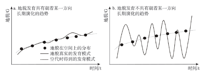
需要注意的是,由于各态遍历性需要服从平稳随机过程,因此,在进行地貌发育的时空代换之前,应当首先保证该种地貌具有朝着某一方向长期演化的趋势,也即函数G = F(A, M, T)随着t的变化呈现单调变化(或近似单调)的特征,否则会导致基于空代时的方法得到的地貌发育模式与真实的情况大相径庭(图2)。
3.2 地貌学空代时方法的基本类型
按照一定的科学原则与依据对研究对象进行类型划分,是深化对事物认知与理解的重要手段。本文从地貌发育的本质特征入手,以科学性、系统性、实用性以及可表达性为原则,从时空演替的成因机理、分析过程中的空间尺度以及模型的表达方式3个角度,对地貌学空代时方法进行类型划分。3.2.1 基于成因机理分类 根据形成地貌发育时空演替现象的成因机理,划分为内营力差异为主型、外营力差异为主型、地表组成物质差异为主型和发育时间差异为主型(表1)。
Tab. 1
表1
表1基于成因机理的地貌学空代时方法分类
Tab. 1The classification of space-for-time substitution based on landform forming process
| 类型 | 基本特征 | 典型案例 |
|---|---|---|
| 内营力差异为主型 | 地貌发育的空间差异性主要由地壳运动的幅度和规模的空间差异性导致,其所涉及的空间尺度往往较大。 | 由于地壳抬升幅度的不均一性,导致局部地区流域地势产生显著的空间差异 |
| 外营力差异为主型 | 由于降雨、风力等外动力的空间差异,导致所塑造的地貌特征在形态、类型与组合上亦出现与之对应的空间差异性。 | 在黄土高原重点水土流失区,在地表物质组成和下伏基岩类型相对一致的某些区域,由于降雨侵蚀力的空间变化,导致黄土地貌的分布在这些区域呈现出相应的变化 |
| 组成物质差异为主型 | 地表的各种岩石因其矿物成分、硬度、交接程度、水理性质、结构与产状不同,其抗外力剥蚀的能力常表现出很大差别,形成地貌类型或地表形态的空间差异性。 | 软硬相间分布的岩石在水平方向上常导致河谷盆地与峡谷相间分布,在垂直方向上则形成陡缓更替的阶状山坡 |
| 发育时间差异为主型 | 在其它地貌形成作用相似的情况下,发育时间越长,同一种地貌将显现出更为“年长”的形态与类型特征。 | 由于板块碰撞沿某一特定方向传播,导致在碰撞传播方向分布的流域地势呈现渐进变化 |
新窗口打开
3.2.2 基于分析尺度分类 地貌的演化通常具有不同的空间与时间尺度,不同空间尺度下的地貌过程对应着不同的时间尺度。因而,将空间变量转化与代换为时间变量的过程中必然首先涉及到空间尺度选择的问题。基于分析尺度的地貌学空代时方法类型可划分为坡面尺度空代时、局地尺度空代时以及区域尺度空代时。
以黄土地貌为例,坡面尺度可以对应黄土坡面上细沟、浅沟的发育过程;局地尺度对应黄土小流域中不同级别切沟与冲沟的发育过程;而区域尺度则对应同一发育模式下,不同空间位置黄土小流域的发育过程。
3.2.3 基于模型表达方式分类 在得到了地貌演化的时间序列后,需要对其演化模式进行科学的表达。基于模型表达方式的类型可划分为对地貌发育过程的定性描述、对地貌发育规律的定量表达以及定性与定量相结合表达方法。
定性描述主要依据研究者的直觉、经验或根据地貌实体的过去和现在的延续状况及最新的信息资料,对地貌现象的性质、特点和发展变化做出判断,通常运用自然语言或图形化语言进行表述,它既有可能是在对某一地貌现象认识的初级阶段,对于该现象的简单描述,也有可能是在深入研究地貌现象后对其进行的规律性总结;定量表达往往是在定性分析的基础之上,通过数理方法,对地貌现象进行定量化的描述与表达;在实际分析中,往往通过定性与定量分析的有机结合来实现研究目标。其中,集“形”、“数”、“理”为一体的地学信息图谱方法,可发挥重要的作用。
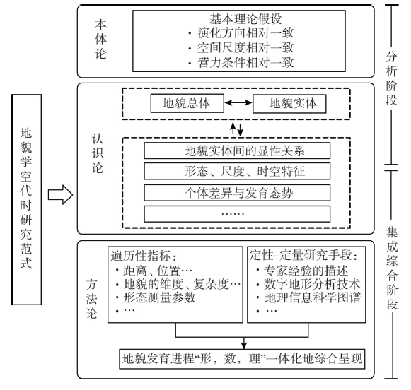
3.3 地貌学空代时研究范式的思考
系统论观点认为,事物都是由要素所构成的系统,其整体性能大于部分之和,且系统是不能还原、自动演进的。作为地貌系统的组成部分,地貌实体在空间上具有不同的延展性和衰变性,而在时间上则具有历史的记忆性和继承性。同时,由地理学第一定律可知,在一定尺度下的地貌具有其时空相似性。以上均是利用空代时方法进行地貌演化发育研究的理论基础。地貌学空代时不仅仅是一种研究方法,更应升华为一种理论乃至研究范式,从而扩展地貌学研究的方法与理论体系。科学范式被认为是科学的本体论、认识论和方法论,是科学体系的基本模式、基本结构与基本功能[39]。简而言之,它是科学研究群体针对某一领域开展研究时所要共同遵守的准则。研究范式可以用来界定什么应被研究、什么问题应被提出、如何对科学问题进行质疑与解释[39-40]。从这个角度出发,地貌学空代时研究范式的主要目标是通过全面比较和分析一定空间尺度内,不同发育年龄、不同发育阶段的一系列相似地貌实体,推测地貌综合体的长期演化过程。此外,① 从本体论角度,地貌学空代时研究范式应遵循一定的理论假设,即地貌体应具有相对一致的演化方向、相对一致的空间尺度以及相对一致的营力条件。② 从认识论角度,系统科学观点认为,不同地理事物以及地理现象之间是相互关联的。通过分析各地貌体的形态特征、结构特性等,需要充分厘清:这些地貌实体具有什么样的显性关系?其形态和结构特点具有怎样的层次性和尺度关系?又具有怎样的时空特征?地貌个体的差异性如何系统揭示地貌综合体的整体发育态势?这些问题都是地貌学空代时理论需要研究和探讨的。此外,地貌总体的空间尺度和所要推测的地貌演化时间尺度都会影响推测的精度。一般来说,地貌总体所涉及的空间尺度越大,演化推测的时间尺度越长,所引入的干扰因素就越多,基于空代时方法所建立的地貌演化序列的可信度就越低。③ 从方法论角度,空代时的研究方法常利用遍历性指(ergodic indicator)来表示研究对象在空间序列以及时间序列上的变化特征。不同于在生态学研究中将物种组成、物种优势度、丰富度指数、多样性指数、均匀度等作为遍历性指标,在地貌演化的研究往往以距离、位置、地貌的维度或复杂度等形态测量参数作为遍历性指标。近15年来,随着遥感、地理信息技术以及其他数据获取方法的迅速发展,使得研究者们能够用精确的定量化指标来表达地貌的演变特征,以进行更加严格的时空统计检验。同时,地学信息图谱作为地理信息科学的一种研究理论与方法,将其引入地貌学空代时研究范式,有助于厘清地貌发育演化“形”、“数”、“理”的全局关系。
简言之,利用地貌学空代时研究范式进行科学研究可概括为两个阶段(图3):① 分析阶段。确定该种地貌是否具有朝着某一方向长期演化的趋势,其次明确研究对象的空间尺度,确定在该尺度下的地貌形成作用,包括内外营力、原始地形、地表物质组成等,在此基础上,按照相对一致的地貌形成作用确定地貌总体。需要特别注意的是,地貌体是否具有同一方向长期演化趋势,以及是否具有相对一致的地貌形成作用,是利用空代时理论进行地貌学研究的前提。② 集成综合阶段。根据具体子地貌体的特点,确定以一系列不同形态特征的地貌个体作为其时间序列的真实代表,并以模型化或图形化的语言进行科学合理地表达,对地貌总体的发育过程进行综合系统地呈现。
 显示原图|下载原图ZIP|生成PPT
图3地貌学空代时研究范式基本框架图
-->Fig. 3Frame diagram of paradigm of space-for-time substitution in geomorphology
-->
4 结论
地貌学的重要科学命题之一即探究地球表面形态的发生、发展规律。空代时方法基于各态遍历性假设,是研究某种对象在时间序列上的变化特征的一种重要方法手段,被广泛地应用于生态学、地貌学等领域。空代时作为一种科学研究范式,在不同的学科应用中具有一定的共性特征,即通过特定的遍历性指标,采用统计学方法,反演出系统的时空演化过程。而该方法应用于特定的学科,又具有一定的个性差异。本文提出了地貌学空代时方法的适用条件、影响因素及基本类型,以期为地貌发育过程和演化机理的研究提供借鉴和参考。地貌学研究的其中一个重要手段就是类比分析,外界条件相似的不同区域的地貌,以及相同地貌类型所指示的相似外界条件之间的类比,都为地貌发育规律的认识提供了有效的手段。而地貌学空代时方法则另辟蹊径,是一种在时间和空间序列发展趋势上相互演替、相互预测的方法。随着今后研究的进一步深入,地貌学空代时方法通过与遥感图像处理、数字地形分析和地学信息图谱等研究方法相结合,有望完善其基本研究范式,更加深入地理解地貌发育演化的过程与机理。
The authors have declared that no competing interests exist.
参考文献 原文顺序
文献年度倒序
文中引用次数倒序
被引期刊影响因子
| [1] | The evolution of loess-covered landforms is largely controlled by the pre-Quaternary underlying bedrock terrain, which is one of the most important factors in understanding the formation mechanism of the landforms. This study used multiple data sources to detect 1729 outcropping points of underlying terrain, in order to construct a digital elevation model (DEM) of the paleotopography of an area of the Loess Plateau subject to severe soil erosion. Four terrain characteristics, including terrain texture, slope gradient the hypsometric curve, and slope aspect, were used to quantify topographic differences and reveal the loess-deposition process during the Quaternary. A loess thickness map was then created to show the spatial distribution of loess deposits in the test area. Finally, the geomorphological inheritance characteristics of the loess-covered landforms were evaluated in different landform divisions. The results showed the significant inheritance of modern topography from the underlying topography with a similar general relief trends. The average thickness of loess deposits was computed to be 104.6 m, with the thickest part located in the Xifeng loess tableland area. In addition, the slope aspects of the North and Northwest seem to have favored Quaternary loess deposition, which supported the hypothesis of an eolian origin for loess in China. The modem surface has lower topographic relief compared to the underlying terrain due to loess deposition. Crown Copyright (C) 2013 Published by Elsevier B.V. All rights reserved. |
| [2] | 黄土区沟谷侵蚀与气候变化有密切关系。黄土是干冷气候环境中堆积的地质体,只有在干冷时期才是稳定的。气候变湿润时黄土区发生冲沟侵蚀。洛川黄土塬区20万年以来至少出现过五次明显的侵蚀时期,该区河流的侵蚀与堆积过程恰好和冲沟发育过程相反,但两者在时间上可以较好地对比。 . 黄土区沟谷侵蚀与气候变化有密切关系。黄土是干冷气候环境中堆积的地质体,只有在干冷时期才是稳定的。气候变湿润时黄土区发生冲沟侵蚀。洛川黄土塬区20万年以来至少出现过五次明显的侵蚀时期,该区河流的侵蚀与堆积过程恰好和冲沟发育过程相反,但两者在时间上可以较好地对比。 |
| [3] | <p>阿尔泰山喀纳斯河流域在第四纪期间发生过多次冰川进退,丰富的侵蚀与堆积地貌为区域地貌演化过程分析提供了重要依据,同时,该区的第四纪冰川作用对全球环境变化研究具有重要的科学意义。通过对喀纳斯湖口以下主谷内古冰川地貌的实地考察,测定不同地段多级U型谷底(台地)的海拔高度以及冰川漂砾的上限与分布位置,并对主谷内不同地段不同期次的冰碛物进行电子自旋共振(ESR)测年,研究发生在主谷内的古冰川作用系列、规模及演化过程。结果表明:喀纳斯湖到驼颈湾地区的谷地中主要发生过4次冰川作用,时代分别对应中梁贛冰期(MIS12)、MIS8/10、倒数第二次冰期(MIS6)以及末次冰期。末次冰期冰川作用又可细分为3个阶段,分别对应MIS4、MIS3中期与MIS2;根据三级U型谷的分布特征推断,古冰川作用规模呈现渐次变小的规律,自冰川站至下游接近冰川末端,中梁贛冰期时冰川厚度达50~395 m,覆盖范围包括主谷及两侧的山梁和支谷,延伸的长度和宽度都最大,MIS8/10以及倒二冰期时的厚度分别在102~199 m和88~269 m之间,冰川末端到达驼颈湾附近;鸭泽湖附近坡地上保存完好的多级台地,说明发生在河谷内的古冰川活性大,流动性和连续性较强,具有温冰川的性质;喀纳斯主谷有明显的不对称性,与局部小气候和地形对冰川的发育影响有关。</p> . <p>阿尔泰山喀纳斯河流域在第四纪期间发生过多次冰川进退,丰富的侵蚀与堆积地貌为区域地貌演化过程分析提供了重要依据,同时,该区的第四纪冰川作用对全球环境变化研究具有重要的科学意义。通过对喀纳斯湖口以下主谷内古冰川地貌的实地考察,测定不同地段多级U型谷底(台地)的海拔高度以及冰川漂砾的上限与分布位置,并对主谷内不同地段不同期次的冰碛物进行电子自旋共振(ESR)测年,研究发生在主谷内的古冰川作用系列、规模及演化过程。结果表明:喀纳斯湖到驼颈湾地区的谷地中主要发生过4次冰川作用,时代分别对应中梁贛冰期(MIS12)、MIS8/10、倒数第二次冰期(MIS6)以及末次冰期。末次冰期冰川作用又可细分为3个阶段,分别对应MIS4、MIS3中期与MIS2;根据三级U型谷的分布特征推断,古冰川作用规模呈现渐次变小的规律,自冰川站至下游接近冰川末端,中梁贛冰期时冰川厚度达50~395 m,覆盖范围包括主谷及两侧的山梁和支谷,延伸的长度和宽度都最大,MIS8/10以及倒二冰期时的厚度分别在102~199 m和88~269 m之间,冰川末端到达驼颈湾附近;鸭泽湖附近坡地上保存完好的多级台地,说明发生在河谷内的古冰川活性大,流动性和连续性较强,具有温冰川的性质;喀纳斯主谷有明显的不对称性,与局部小气候和地形对冰川的发育影响有关。</p> |
| [4] | Landscapes on Earth retain a record of the tectonic, environmental and climatic history under which they formed. Landscapes tend towards an equilibrium in which rivers attain a stable grade that balances the tectonic production of elevation and with hillslopes that attain a gradient steep enough to transport material to river channels. Equilibrium low-relief surfaces are typically found at low elevations, graded to sea level. However, there are many examples of high-elevation, low-relief surfaces, often referred to as relict landscapes, or as elevated peneplains. These do not grade to sea level and are typically interpreted as uplifted old landscapes, preserving former, more moderate tectonic conditions. Here we test this model of landscape evolution through digital topographic analysis of a set of purportedly relict landscapes on the southeastern margin of the Tibetan Plateau, one of the most geographically complex, climatically varied and biologically diverse regions of the world. We find that, in contrast to theory, the purported surfaces are not consistent with progressive establishment of a new, steeper, river grade, and therefore they cannot necessarily be interpreted as a remnant of an old, low relief surface. We propose an alternative model, supported by numerical experiments, in which tectonic deformation has disrupted the regional river network, leaving remnants of it isolated and starved of drainage area and thus unable to balance tectonic uplift. The implication is that the state of low relief with low erosion rate is developing in situ, rather than preserving past erosional conditions. |
| [5] | ABSTRACT River networks evolve as migrating drainage divides reshape river basins and change network topology by capture of river channels. We demonstrate that a characteristic metric of river network geometry gauges the horizontal motion of drainage divides. Assessing this metric throughout a landscape maps the dynamic states of entire river networks, revealing diverse conditions: Drainage divides in the Loess Plateau of China appear stationary; the young topography of Taiwan has migrating divides driving adjustment of major basins; and rivers draining the ancient landscape of the southeastern United States are reorganizing in response to escarpment retreat and coastal advance. The ability to measure the dynamic reorganization of river basins presents opportunities to examine landscape-scale interactions among tectonics, erosion, and ecology. |
| [6] | ABSTRACT Geomorphology is currently in a period of resurgence as we seek to explain the diversity, origins and dynamics of terrain on the Earth and other planets in an era of increased environmental awareness. Yet there is a great deal we still do not know about the physics and chemistry of the processes that weaken rock and transport mass across a planet's surface. Discovering and refining the relevant geomorphic transport functions requires a combination of careful field measurements, lab experiments, and use of longer-term natural experiments to test current theory and develop new understandings. Landscape evolution models have an important role to play in sharpening our thinking, guiding us toward the right observables, and mapping out the logical consequences of transport laws, both alone and in combination with other salient processes. Improved quantitative characterization of terrain and process, and an ever-improving theory that describes the continual modification of topography by the many and varied processes that shape it, together with improved observation and qualitative and quantitative modelling of geology, vegetation and erosion processes, will provide insights into the mechanisms that control catchment form and function. This paper reviews landscape theory in the form of numerical models of drainage basin evolution and the current knowledge gaps and future computing challenges that exist. Copyright 2010 John Wiley & Sons, Ltd. |
| [7] | This paper reviews the main physical laws proposed in landscape evolution models (LEMs). It discusses first the main partial differential equations involved in these models and their variants. These equations govern water runoff, stream incision, regolith-bedrock interaction, hillslope evolution, and sedimentation. A synthesis of existing LEMs is proposed. It proposes three models with growing complexity and with a growing number of components: two-equation models with only two components, governing water and bedrock evolution; three-equation models with three components where water, bedrock, and sediment interact; and finally models with four equations and four interacting components, namely water, bedrock, suspended sediment, and regolith. This analysis is not a mere compilation of existing LEMs. It attempts at giving the simplest and most general physically consistent set of equations, coping with all requirements stated in LEMs and LEM software. Three issues are in particular addressed and hopefully resolved. The first one is a correct formulation of the water transport equation down slopes. A general formulation for this equation is proposed, coping not only with the simplest form computing the drainage area but also with a sound energy dissipation argument associated with the Saint-Venant shallow water equations. The second issue arises from the coexistence of two competing modes, namely the detachment-limited erosion mode on hillslopes, and the transport-limited sediment transport on river beds. The third issue (linked to the second) is the fact that no conservation law is available for material in these two modes. A simple solution proposed to resolve these issues is the introduction, as suggested by several authors, of an additional variable for suspended sediment load in water. With only three variables and three equations, the above-mentioned contradictions seem to be eliminated. Several numerical experiments on real digital elevation models (DEMs) illustrate the discussion and show results of landscape evolution with the proposed synthetic models. (C) 2014 Elsevier B.V. All rights reserved. |
| [8] | Abstract Cellular automata (CA) have been used increasingly to simulate complex geographical phenomena. This paper proposes a CA model for simulating the evolution of dynamic positive and negative (P–N) terrains in a small loess watershed. The CA model involves a large number of attributes, including the state of P–N terrains, distance to the shoulder-line, neighbourhood condition and topographic factors. Topographic factors include the slope gradient, aspect, slope length, slope variation, aspect variation, plan curvature, profile curvature, relief amplitude and flow accumulation. The CA model was applied to simulate the evolution of P–N terrains in an indoor, small loess watershed under artificial rainfall. The transition rules for CA were constructed automatically using a decision-tree algorithm. The derived transition rules are explicit for decision-makers and helpful for generating more reliable terrains. The simulation produces encouraging results in terms of numeric accuracy and spatial distribution, in agreement with natural P–N terrains. The iterative processes show that loess negative terrains continuously erode positive terrains. The development of a loess sinkhole near the centre gully head was reproduced as well, which shows the function of loess sinkholes in the formation of loess channel systems. |
| [9] | <p>元胞自动机是一个时空离散的动力学模型,是复杂系统的研究方法之一。从80年代后期开始,在许多领域都得到广泛的应用与发展。地貌是一个非线性动态复杂系统,元胞自动机模型(或更广意义上的元胞模型)为研究复杂地貌系统的动态演化提供了新的方法论工具。本文根据近些年国内外该领域的研究成果,对元胞模型在地貌演化模拟中的应用及进展进行了探讨,并分析了元胞模型方法在地貌演化模拟中的优势和不足。</p> . <p>元胞自动机是一个时空离散的动力学模型,是复杂系统的研究方法之一。从80年代后期开始,在许多领域都得到广泛的应用与发展。地貌是一个非线性动态复杂系统,元胞自动机模型(或更广意义上的元胞模型)为研究复杂地貌系统的动态演化提供了新的方法论工具。本文根据近些年国内外该领域的研究成果,对元胞模型在地貌演化模拟中的应用及进展进行了探讨,并分析了元胞模型方法在地貌演化模拟中的优势和不足。</p> |
| [10] | <p>从海面-地面系统出发,对三角洲地貌演变模拟模型进行了完整构建,它是包括地面高程、沉积厚度、地壳垂直运动速率与古海面波动等在内的多变量地学过程模拟模型。根据长江三角洲地区的实际资料,运用该模型对长江三角洲全新世时期的地貌演变过程进行了初步模拟,从模型输出的各时期古地貌图来看,效果良好。模拟结果表明:以太湖平原为主体的长江三角洲平原南部区域的地貌演进过程可大致以7000 a BP和3000 a BP为界划分为早期快速海侵,中期岸线反复摆动,晚期迅速海退三个阶段;太湖平原核心区始终未曾遭受过大规模海侵,基本保持为陆地环境,但太湖平原西缘和太湖湖盆等部分区域可能曾数度受到过海侵的影响。分别利用304个分文化期考古点数据和73个考古点测年数据对模拟结果进行了定性和定量验证,验证结果表明:模型对全新世长江三角洲古地貌和海陆关系演变的模拟结果有较好的可信度。</p> . <p>从海面-地面系统出发,对三角洲地貌演变模拟模型进行了完整构建,它是包括地面高程、沉积厚度、地壳垂直运动速率与古海面波动等在内的多变量地学过程模拟模型。根据长江三角洲地区的实际资料,运用该模型对长江三角洲全新世时期的地貌演变过程进行了初步模拟,从模型输出的各时期古地貌图来看,效果良好。模拟结果表明:以太湖平原为主体的长江三角洲平原南部区域的地貌演进过程可大致以7000 a BP和3000 a BP为界划分为早期快速海侵,中期岸线反复摆动,晚期迅速海退三个阶段;太湖平原核心区始终未曾遭受过大规模海侵,基本保持为陆地环境,但太湖平原西缘和太湖湖盆等部分区域可能曾数度受到过海侵的影响。分别利用304个分文化期考古点数据和73个考古点测年数据对模拟结果进行了定性和定量验证,验证结果表明:模型对全新世长江三角洲古地貌和海陆关系演变的模拟结果有较好的可信度。</p> |
| [11] | <p>中国东北黑土资源以土壤肥沃、有机质含量高、土质疏松、最适宜耕作而闻名于世。长期以来,由于人类的过度垦殖和不合理耕作, 造成大规模的水土流失,侵蚀沟不断切割地表,蚕食耕地,冲走沃土,降低了大型机械的耕作效率。侵蚀沟研究是土壤侵蚀研究的重要组成部分,在遥感和GIS 技术支持下,选取黑龙江克拜地区作为典型研究案例,以侵蚀沟密度为主要指标,分析了研究区侵蚀沟密度的动态变化、侵蚀沟变化的高程分异特征、坡度分异特征、坡向分异特征以及侵蚀沟变化与地貌类型的关系,揭示了典型黑土区50多年来侵蚀沟的动态变化特点和空间分异规律。</p> . <p>中国东北黑土资源以土壤肥沃、有机质含量高、土质疏松、最适宜耕作而闻名于世。长期以来,由于人类的过度垦殖和不合理耕作, 造成大规模的水土流失,侵蚀沟不断切割地表,蚕食耕地,冲走沃土,降低了大型机械的耕作效率。侵蚀沟研究是土壤侵蚀研究的重要组成部分,在遥感和GIS 技术支持下,选取黑龙江克拜地区作为典型研究案例,以侵蚀沟密度为主要指标,分析了研究区侵蚀沟密度的动态变化、侵蚀沟变化的高程分异特征、坡度分异特征、坡向分异特征以及侵蚀沟变化与地貌类型的关系,揭示了典型黑土区50多年来侵蚀沟的动态变化特点和空间分异规律。</p> |
| [12] | <p>运用钻探和浅地层探测等最新调查成果, 对近20 年的辽河三角洲潮流沉积进行了研 究。根据不同时期水深地形和卫星影像资料对比分析了现代辽河三角洲潮流地貌变化。现代辽河三角洲的沉积主体位于双台子河口。研究区10 m 深度内的地层主要包括: 潮滩相、潮 道相和浅海相沉积, 其下为古三角洲相。潮滩相沉积物以砂和粉砂为主, 分选中等, 跳跃和悬浮组分各占50%左右; 浅海相和潮道相沉积物主要为软弱的粘土质粉砂和粉砂质粘土, 以悬浮组分为主。全新世以来至1896 年, 研究区为古辽河、古大凌河和绕阳河之间的小海湾。 1896 年, 双台子河被人工开挖为分洪河道以来, 口门外形成盖州滩等潮滩, 并快速发育。 1958 年, 双台子河建闸后, 入海径流量和输沙量减小。目前, 双台子河口整体处于淤积状态, 潮滩面积不断增加, 整体向南、西、北3 个方向扩展。潮滩最大淤进速率为87~683 m/a, 平均淤积速率为0.189 m/a。潮滩东侧局部发生侵蚀, 平均侵蚀速率为0.122 m/a。潮道面积缩小, 具有向西、向北迁移的趋势, 最大迁移速率为48~200 m/a。双台子河口地貌发育受径流、海洋动力和人类活动的影响, 沉积物的主要来源由双台子河河流输沙演变为潮流和沿岸流输沙。</p> . <p>运用钻探和浅地层探测等最新调查成果, 对近20 年的辽河三角洲潮流沉积进行了研 究。根据不同时期水深地形和卫星影像资料对比分析了现代辽河三角洲潮流地貌变化。现代辽河三角洲的沉积主体位于双台子河口。研究区10 m 深度内的地层主要包括: 潮滩相、潮 道相和浅海相沉积, 其下为古三角洲相。潮滩相沉积物以砂和粉砂为主, 分选中等, 跳跃和悬浮组分各占50%左右; 浅海相和潮道相沉积物主要为软弱的粘土质粉砂和粉砂质粘土, 以悬浮组分为主。全新世以来至1896 年, 研究区为古辽河、古大凌河和绕阳河之间的小海湾。 1896 年, 双台子河被人工开挖为分洪河道以来, 口门外形成盖州滩等潮滩, 并快速发育。 1958 年, 双台子河建闸后, 入海径流量和输沙量减小。目前, 双台子河口整体处于淤积状态, 潮滩面积不断增加, 整体向南、西、北3 个方向扩展。潮滩最大淤进速率为87~683 m/a, 平均淤积速率为0.189 m/a。潮滩东侧局部发生侵蚀, 平均侵蚀速率为0.122 m/a。潮道面积缩小, 具有向西、向北迁移的趋势, 最大迁移速率为48~200 m/a。双台子河口地貌发育受径流、海洋动力和人类活动的影响, 沉积物的主要来源由双台子河河流输沙演变为潮流和沿岸流输沙。</p> |
| [13] | <p>本文研究盐城串场河一线至黄海60 km宽的海积平原海岸演变过程。对1975 年的MSS影像,进行遥感匀光处理、阈值分割等影像解译,获取了盐城海积平原古海岸演变解译图,即“斑马条纹”二值图;对19 个实测底质样品进行分析,发现海积平原呈现砂质(粗颗粒) 与淤泥质(细颗粒) 沉积相间平行的分布规律,而这一空间交替分布特征与解译图上“斑马条纹”的二值条带具有良好的对应关系;同时,搜集整理了近几十年来的盐城古海岸调查资料与研究成果,发现前人历史岸线的空间分布与“斑马条纹”整体趋势相同。综上所述,“斑马条纹”应为盐城海岸演变标志,解译出砂冈10 条,冈间低地10 条,形成了对盐城海积平原地貌沉积及海岸演变过程的新认识。</p> . <p>本文研究盐城串场河一线至黄海60 km宽的海积平原海岸演变过程。对1975 年的MSS影像,进行遥感匀光处理、阈值分割等影像解译,获取了盐城海积平原古海岸演变解译图,即“斑马条纹”二值图;对19 个实测底质样品进行分析,发现海积平原呈现砂质(粗颗粒) 与淤泥质(细颗粒) 沉积相间平行的分布规律,而这一空间交替分布特征与解译图上“斑马条纹”的二值条带具有良好的对应关系;同时,搜集整理了近几十年来的盐城古海岸调查资料与研究成果,发现前人历史岸线的空间分布与“斑马条纹”整体趋势相同。综上所述,“斑马条纹”应为盐城海岸演变标志,解译出砂冈10 条,冈间低地10 条,形成了对盐城海积平原地貌沉积及海岸演变过程的新认识。</p> |
| [14] | 通过对长江口潮间带宽度、表层和浅地层柱状样沉积物、典型水下岸坡剖面的现场测量,以及对潮间带宽度及水下岸坡剖面的多幅历史海图分析,研究近30 年长江口岸滩演变特征及岸滩演变的主要原因。结果表明:(1) 岸滩沉积物整体上呈“北细南粗”的变化特征,横沙东滩北岸、长江和东海大桥下等主要大型工程附近潮间带柱状样粒序向上显著变粗;(2) 长江口部分潮间带宽度减少90%以上;水下岸坡由1980 年的“S”形向凹形、斜坡形等侵蚀型形态转变,岸坡明显变陡,侵蚀型岸滩特征凸显;南汇嘴至芦潮港岸段水下岸坡闭合水深1978-2004 年为-8 m,近10 年来滩底发生侵蚀,刷深约1 m;(3) 流域来沙量锐减导致长江口侵蚀型水下岸滩格局的形成;河口大面积围垦、青草沙水库和长江与东海大桥等大型工程建设是造成潮间带大面积损失和局部沉积物粗化的主要原因;沙体变迁是狭长型河槽局部岸滩演变的主要影响因素。 . 通过对长江口潮间带宽度、表层和浅地层柱状样沉积物、典型水下岸坡剖面的现场测量,以及对潮间带宽度及水下岸坡剖面的多幅历史海图分析,研究近30 年长江口岸滩演变特征及岸滩演变的主要原因。结果表明:(1) 岸滩沉积物整体上呈“北细南粗”的变化特征,横沙东滩北岸、长江和东海大桥下等主要大型工程附近潮间带柱状样粒序向上显著变粗;(2) 长江口部分潮间带宽度减少90%以上;水下岸坡由1980 年的“S”形向凹形、斜坡形等侵蚀型形态转变,岸坡明显变陡,侵蚀型岸滩特征凸显;南汇嘴至芦潮港岸段水下岸坡闭合水深1978-2004 年为-8 m,近10 年来滩底发生侵蚀,刷深约1 m;(3) 流域来沙量锐减导致长江口侵蚀型水下岸滩格局的形成;河口大面积围垦、青草沙水库和长江与东海大桥等大型工程建设是造成潮间带大面积损失和局部沉积物粗化的主要原因;沙体变迁是狭长型河槽局部岸滩演变的主要影响因素。 |
| [15] | An experimental study was undertaken to document the evolution of a drainage basin and to identify hydrologic changes. A 9 by 15 m facility was built and filled with a homogeneous mixture of sand, silt, and clay. A sprinkling system was established along the sides of the container, and it provided four intensities of rainfall to the nearly 140 sq. m drainage basin. Two experiments were performed each of which documented the evolution of the drainage system on gently sloping surfaces. The initial conditions (relief and initial surface slope) of each experiment were different, and these initiated differences in the mode of network growth. Nevertheless, during both experiments drainage patterns evolved through the sequence of network initiation, extension of the network to maximum extension, and, finally, to abstraction. Sediment yields from the basin undergoing erosional evolution show an exponential decline with time. This overall trend is characterized by high variability. Hydrographs generated as basin evolution progressed suggest that runoff produced by lower precipitation intensities is most influenced by the geomorphology of the basin. The ratio of peak discharge to the equilibrium discharge shows a dramatic increase during early basin development. The efficiency of the hydrologic response, appears to increase to a maximum as drainage density and/or relief increases. Further increases in drainage density do not increase the efficiency of the hydrologic system. (Author) |
| [16] | The authors bring together the results of several years of experimental work in drainage basin evolution, hydrology, river-channel morphology, and sedimentology. These investigations are related to real-world applications, particularly geological exploration and mapping. This text shows how awareness of natural phenomena can improve management of the natural environment, such as the control of rivers and eroding gullies. |
| [17] | Four experiments in alluvial drainage basin evolution were carried out in the Rainfall Erosion Facility (REF) at Colorado State University to investigate the dependence of basin evolution on initial topography. Basins were initially undissected. Each experiment began with a unique initial condition representing various end-members of relief and hypsometry. Drainage network development, hillslope processes, basin denudation, and basin response to base-level lowering all depended strongly on the initial topography. No classic model of drainage network evolution was found to be generally applicable. Initially, planar slopes first developed subparallel channels that extended headward dendritically during an early phase of extension. Channel incision occurred first in the interior of the basin where saturation overland flow was greatest, not at the basin outlet as assumed in most classic models of network development. Channels widened over time, initiating lateral migration and drainage capture in the downslope portion of the watershed before transferring lateral migration upslope. Planar basins of larger initial gradient grew headward more quickly and become more deeply entrenched, inhibiting late-stage lateral migration. An experiment with initial relief concentrated at a plateau edge evolved in several unique ways. A high ratio of subsurface-to-surface flow gave rise to mass movements at the plateau edge and outlet channels. Deep channels were quickly cut initially but did not extend far upslope because slope instability undermined channel head migration, leaving the plateau undissected and hence very slow to erode. These results suggest that the distribution of relief within a basin exerts an important control on drainage network pattern and basin denudation. In addition, erosional basins may evolve in several distinct modes characterized by particular combinations of hypsometry, hillslope processes, and mean denudation rate. |
| [18] | |
| [19] | [D]. [D]. |
| [20] | . |
| [21] | Abstract It sometimes seems natural to separate ecologists by a dichotomy of data- collecting, direct-observation oriented scientists and computer-oriented modelers. However, in the most general sense, any ecologist regularly uses conceptual models to structure scientific endeavor. It is these models that give intrinsic meaning to ecological data. Most scientists realize that the reason one collects the information needed for a particular study comes from a long tradition of concepts built over some number of years. The importance of conceptual models to scientists should not be underestimated in any ecological studies, long- term or otherwise. |
| [22] | Geomorphology and time. Post a Comment. CONTRIBUTORS: Author: Thornes, JB. Author:Brunsden, D. PAGES (INTRO/BODY): xvi, 208 p. SUBJECT(S): Geomorphology; Geological time;Methodology. DISCIPLINE: No discipline assigned. LC NUMBER: GB400.4 .T46 1977b. |
| [23] | The variational lower bound v>0.39 pi(2) determined by Ivers (1984) for the infimum decay rate v of axisymmetric poloidal magnetic fields is corroborated numerically and an upper bound v<0.66 pi(2) established. This is achieved by correcting and extending results for certain flows considered by Chandrasekhar (1956). |
| [24] | |
| [25] | . |
| [26] | The arc-continent collision in Taiwan has resulted in surface uplift, high relief and high rates of erosion. Because the collision is older in the north and has propagated southward, Taiwan offers the opportunity to study the evolution of topography as it evolves towards a large-scale steady state. In this paper, we analyze a 40-m digital elevation model of Taiwan to determine how topographic steady state is expressed in the landscape; particular attention is paid to the eastern Central Range, where major drainage basins are approximately aligned in the direction of the collision propagation. Analyses of orogen size, regional topographic slope, drainage basin hypsometry, and local topographic slope reveal a geomorphological transition 100 125km north of the southern tip of the island. To the south of this transition, topographic characteristics change with distance along the island; to the north, these characteristics are relatively constant, which we interpret as representing large-scale topographic steady state. Assuming that the collision has propagated southward at a rate of 55mm/yr, the time to topographic steady state is 1.8 2.3Myr after emergence above sea level. Within the steady state region, we evaluate regional variability in the topography and find that the most prominent deviations from a steady form are associated with large-scale structures, though our analyses of local topographic slope and river profile form suggest that spatial variations in rock strength and rock uplift rate also contribute to regional topographic variability. |
| [27] | We used high-resolution topography, geomorphic mapping of activesurface processes, and geologic mapping to study the topographicand erosional response of small drainage basins to rock upliftalong the Dragon's Back pressure ridge along the San Andreasfault in the Carrizo Plain, California. We infer the historyof deformation experienced by ~40 small drainage basins formedin poorly consolidated sedimentary rocks. A space-for-time substitutiondirectly images the erosional and topographic responses to deformation.Progressive deformation and rock uplift are accompanied by increasesin channel steepness and basin relief. As uplift ceases, channelconcavity rapidly increases, causing channels to undercut hillslopes hisundercutting promotes the consumption of hillslopes by landsliding.This undercutting also causes basin relief to be greatest afteruplift has stopped. This analysis indicates that channels ofthe Dragon's Back pressure ridge respond to changes in rockuplift rates over thousands of years, whereas hillslope processesmay take more than an order of magnitude longer to adjust tochanges in rock uplift rates. Our study directly measures changesin erosional processes due to the initiation and cessation ofrock uplift, which can typically only be inferred using numericalmodels, by direct field observations. |
| [28] | ABSTRACT A morphometric comparison of valleys has been made for the Ben Ohau Range in the central Southern Alps of New Zealand. The range is undergoing rapid tectonic transport and uplift. The humid north of the range is a glacial trough-and-arête landscape, with a temperate glacial climate. The dry south has rounded divides and plateau remnants dissected by fluvial valleys. Assuming that space–time substitution allows today's spatial valley-form transition to represent evolutionary stages in valley development, the tectonic history allows time constraints to be placed on the rate of transition to an alpine glacial landscape. Morphometric change has been quantified using hypsometric curves, and distance–elevation plots of cirque and valley-floor altitudes. Ancestral fluvial valleys have less concave long profiles but are stepped at altitude owing to the presence of high-level cirques and remnant plateau surfaces, and possess a low proportion of land area at low elevation. Increasing glacial influence is manifest as smoother, more deeply concave long profiles and U-shaped cross-profiles associated with a higher proportion of the land area at lower elevation. The full morphological transition has involved up to 2.4 km of vertical denudation over the 4 Ma lifetime of the mountain range, of which 80 per cent would have occurred by preglacial fluvial erosion. Combining the trajectory of tectonic transport with reconstructed glaciation limits and climatic history, it is indicated that about 200 ka of temperate glacial erosion produces recognizable trough-and areête topography. Mean and modal relief increase where glacial activity is confined to cirques, but decrease when trough incision by ice becomes established as a dominant process in the landscape. 08 1997 by John Wiley & Sons, Ltd. |
| [29] | 运用过程响应模型实验方法 ,在游荡型模型小河塑造过程中 ,分析了游荡河型发育过程中出现的时间和空间演变过程 ,发现其时、空演替过程可以相互替代 ,从而在实验室内证实了空代时假说的存在性 ,为空代时假说提供了新的证据。并据此把复杂响应过程分为时间复杂响应过程和空间复杂响应过程 ,分析了游荡河型发育过程中出现的时空复杂响应现象 . 运用过程响应模型实验方法 ,在游荡型模型小河塑造过程中 ,分析了游荡河型发育过程中出现的时间和空间演变过程 ,发现其时、空演替过程可以相互替代 ,从而在实验室内证实了空代时假说的存在性 ,为空代时假说提供了新的证据。并据此把复杂响应过程分为时间复杂响应过程和空间复杂响应过程 ,分析了游荡河型发育过程中出现的时空复杂响应现象 |
| [30] | 在概述河流自然模型试验定义和前人众多试验研究的基础上,讨论了试验时间的确定对河流自然模型试验的意义。结合对概化水槽试验的分析,论述了河流自然模型试验时效的定义、实质及其影响因素,初步得出试验时效与河床组成、河谷比降以及流量的关系,并提出时效的判定指标。通过相似理论以及河段裁弯概化模型试验与天然河流的对比,对其合理性进行了初步验证。最后,引入“空代时”假说,分析了该假说在时效验证中的可行性。 . 在概述河流自然模型试验定义和前人众多试验研究的基础上,讨论了试验时间的确定对河流自然模型试验的意义。结合对概化水槽试验的分析,论述了河流自然模型试验时效的定义、实质及其影响因素,初步得出试验时效与河床组成、河谷比降以及流量的关系,并提出时效的判定指标。通过相似理论以及河段裁弯概化模型试验与天然河流的对比,对其合理性进行了初步验证。最后,引入“空代时”假说,分析了该假说在时效验证中的可行性。 |
| [31] | 在实测资料和前人研究的基础上,引入"空代时"假说,分析研究了 丹江口建库后汉江下游河流再造床过程的时空演替现象.分析表明,河流再造床过程在冲刷延展、河床粗化、含沙量及其特征、岸滩侵蚀以及河型变化等方面具有较 典型的时空演替现象.产生时空演替现象的根源在于河流自调整作用在同一变源下空间和时间响应的一致性,是过程的相似.输入水沙条件的变化、水库下游河道支 流入汇、河床边界条件的变化以及因此导致的不同调整方式是引起时空演替复杂响应的主要原因.如能排除干扰、建立时空演替现象的数学模式将有助于水库下游河 流调整的分析和预测. . 在实测资料和前人研究的基础上,引入"空代时"假说,分析研究了 丹江口建库后汉江下游河流再造床过程的时空演替现象.分析表明,河流再造床过程在冲刷延展、河床粗化、含沙量及其特征、岸滩侵蚀以及河型变化等方面具有较 典型的时空演替现象.产生时空演替现象的根源在于河流自调整作用在同一变源下空间和时间响应的一致性,是过程的相似.输入水沙条件的变化、水库下游河道支 流入汇、河床边界条件的变化以及因此导致的不同调整方式是引起时空演替复杂响应的主要原因.如能排除干扰、建立时空演替现象的数学模式将有助于水库下游河 流调整的分析和预测. |
| [32] | ABSTRACT. On the basis of a space–time substitution, rates of cliff retreat and talus development overthe pasttens ofthousands of years were quantified for valley-side slopes along the Shomyo River with a known rate of waterfall recession. Detailed profiles of the valley-side slopes were obtained at 19 sites along the river by map reading and field survey, and the morphologic characteristics of the slopes were then measured. By combining the locations of the slopes with the recession rate of Shomyo Falls, it is estimated that the growth rate of the talus slope is 3.9–7.2 mm/yr, the rate of decline of the cliff is 2.0–4.0 × 10deg/yr, and the retreat rate of the cliff top is 6.2–11.6 mm/yr. |
| [33] | ABSTRACT Applications of ergodic reasoning (or location for time substitution) aid efforts at environmental reconstruction and prediction, providing a useful tool to analyse and communicate stages of landscape evolution. Analysis of the historical range of behaviour and change that a river system has experienced can be used to interpret thresholds that have been breached, and underlying controls and/or triggers for adjustment and change. This information can be used to forecast future trajectories of adjustment and provide target conditions for management activities. This paper uses a case study from upper Wollombi Brook, New South Wales, Australia to demonstrate how ergodic reasoning can be used to assess river behaviour, change and responses to natural and human-disturbances. The 'river evolution diagram' developed by Brierley and Fryirs (Geomorphology and River Management: Applications of the River Styles Framework. Blackwell Publishing: Oxford, 2005) is presented as a means for depicting the range of behaviour and evolutionary variability of this river. These approaches can be readily applied in other systems. Implications for approaches to analysis of river evolution and management are outlined. |
| [34] | Abstract This book outlines a generic set of procedures, termed the River Styles Framework, which provides a set of tools for interpreting river character, behavior, condition, and recovery potential. Applications of the framework generate a coherent package of geomorphic information, providing a physical template for river rehabilitation activities. management and restoration of rivers is a rapidly growing topic for environmental scientists, geologists and ecologists - this book provides a learning tool with which to approach geomorphic applications to river management describes the essential geomorphological principles underlying river behaviour and evolution demonstrates how the River Styles Framework can turn geomorphic theory into practice, to develop workable strategies for restoration and management based on real case studies and authors extensive experience applicable to river systems worldwide synthesises fluvial geomorphology, ecology and management. |
| [35] | Abstract The distribution and morphology of submarine canyons off the eastern United States between Hudson and Baltimore Canyons have been mapped by long-range sidescan sonar. In this area canyons are numerous, and their spacing correlates with overall slope gradient; they are absent where the gradient is less than 3°, are 2 to 10 km apart where the gradient is 3° to 5°, and are 1.5 to 4 km apart where the gradient exceeds 6°. Canyons range from straight to sinuous; those having sinuous axes indent the edge of the continental shelf and appear to be older than those that head on the upper slope and have straighter axes. A difference in canyon age would suggest that canyons are initiated on the continental slope and only with greater age erode headward to indent the shelf. Shallow gullies on the middle and upper slope parts of the canyon walls suggest that submarine erosion has been a major process in a recent phase of canyon development. *Present address: British Petroleum, Moorgate, London EC2Y 9BU, England |
| [36] | Mid-range side-scan sonar images of the US Middle Atlantic continental margin show the presence of a variety of erosional features. We propose a preliminary explanation of evolution of canyons on the middle Atlantic slope. In this model, localized slope failure begins the process of canyon formation. By headward erosion, these depressions extend upslope and form linear sediment chutes. These slope canyons represent the youthful phase in canyon evolution. Slope canyons begin the transition to a mature phase when the canyon heads breach the shelfbreak. Access to the continental shelf leads to the transport of shelf-derived materials through the canyon. During the youthful phase, the dominant mechanism of canyon erosion is the failure of the slope itself. In the mature phase, entrenchment is augmented by the episodic cutting by turbulent sediment suspensions enroute from the shelf to the continental rise and abyssal plain.-from Authors |
| [37] | Incised coastal channels are a specific form of incised channel that are found in locations where stream channels flowing to cliffed coasts have the excess energy required to cut down through the cliff to reach the outlet water body. The southern coast of the Isle of Wight, southern England, comprises soft cliffs that vary in height between 15 and 100 m and which are retreating at rates 1.5 m a , due to a combination of wave erosion and landslides. In several locations, river channels have cut through the cliffs to create deeply (鈮 45 m) incised gullies, known locally as 'Chines'. The Chines are unusual in that their formation is associated with dynamic shoreline encroachment during a period of rising sea-level, whereas existing models of incised channel evolution emphasise the significance of base level lowering. This paper develops a conceptual model of Chine evolution by applying space for time substitution methods using empirical data gathered from Chine channel surveys and remotely sensed data. The model identifies a sequence of evolutionary stages, which are classified based on a suite of morphometric indices and associated processes. The extent to which individual Chines are in a state of growth or decay is estimated by determining the relative rates of shoreline retreat and knickpoint recession, the former via analysis of historical aerial images and the latter through the use of a stream power erosion model. |
| [38] | ABSTRACT Space-for-time substitution is a concept that has been widely applied, but not thoroughly tested, in some fields of geomorphology. The objective of this study is to test whether the concept of space-for-time substitution is valid in reconstructing the evolution of a submarine canyon–channel system in a passive progradational margin. We use multibeam echosounder data and in situ measurements from the south Ebro Margin to analyse the morphology and morphometry of a sequence of submarine valleys ordered in terms of increasing valley thalweg length. The morphological model of submarine valley evolution that we can propose from this analysis is very similar to established models in the literature, which leads us to conclude that time can be substituted by space when reconstructing the evolution of submarine canyon and channel systems in the south Ebro Margin. By extracting morphometric information from the application of the space-for-time substitution model to our data, we identify a series of morphological patterns as a submarine canyon evolves in a passive progradational margin. These include the geometric similarity of canyon planform shape, an increase in canyon draining efficiency and in the influence of flank slope failures, and an evolution towards equilibrium between canyon form and imposed water and sediment load without net erosion or deposition taking place. We also observe that canyon elongation is higher downslope and that the canyon undergoes an early stage of rapid incision similar to the process of “erosion narrowing” reported in terrestrial rivers. We demonstrate that the conclusions of our study are not limited to submarine valleys in the south Ebro Margin but are applicable to othermargins around the world. |
| [39] | 本书从方法论层面系统论述了自然地理学的研究范式。全书共分8章,梳理了自然地理学研究范式及其嬗变过程,明晰了自然地理学的一般研究过程和步骤,阐述了自然地理学研究中的分类与分区、预测、格局与过程、尺度推绎等研究方法与技术,概括与总结了自然地理学中的系统综合及复杂性等研究范式。 本书从方法论层面系统论述了自然地理学的研究范式。全书共分8章,梳理了自然地理学研究范式及其嬗变过程,明晰了自然地理学的一般研究过程和步骤,阐述了自然地理学研究中的分类与分区、预测、格局与过程、尺度推绎等研究方法与技术,概括与总结了自然地理学中的系统综合及复杂性等研究范式。 |
| [40] | 地理学主要关注陆地表层自然和人文要素的空间分异规律研究,针对这一复杂系统的不同问题应该选择不同的研究方式.本文在思考以往地理学研究方式的基础上,将地理学研究范式概括为:地理经验科学研究范式、地理实证科学研究范式、地理系统科学研究范式和地理大数据研究范式.对不同地理科学问题应选取不同的范式加以研究,对有些复杂科学问题应采用多种研究范式加以解决. . 地理学主要关注陆地表层自然和人文要素的空间分异规律研究,针对这一复杂系统的不同问题应该选择不同的研究方式.本文在思考以往地理学研究方式的基础上,将地理学研究范式概括为:地理经验科学研究范式、地理实证科学研究范式、地理系统科学研究范式和地理大数据研究范式.对不同地理科学问题应选取不同的范式加以研究,对有些复杂科学问题应采用多种研究范式加以解决. |
