 , 李秀彬
, 李秀彬Progress and prospect on farmland abandonment
LIShengfa, LIXiubin通讯作者:
收稿日期:2015-09-21
修回日期:2015-11-20
网络出版日期:2016-03-25
版权声明:2016《地理学报》编辑部本文是开放获取期刊文献,在以下情况下可以自由使用:学术研究、学术交流、科研教学等,但不允许用于商业目的.
基金资助:
作者简介:
-->
展开
摘要
关键词:
Abstract
Due to rapid urbanization in China, there will be a high probability of abandonment expansion in the near future. However, few researches focused on this rapid land-use trend in China, leading to inadequate understandings of dynamic mechanism and consequences of this phenomenon. Thus, in the end of the paper, some directions of future research in China were presented: regional and national monitoring of abandonment dynamics, trend and risk assessment, social-economic effects assessment and informed policymaking.
Keywords:
-->0
PDF (815KB)元数据多维度评价相关文章收藏文章
本文引用格式导出EndNoteRisBibtex收藏本文-->
1 引言
区域的土地利用形态是与其经济和社会发展阶段相对应,并随着经济和社会发展阶段的变化而发生转型[1].在城镇化和工业化的起步阶段,人口和经济的不断增长导致了食物与木材,薪柴等需求的增加,从而引起耕地和建设用地的扩张以及林地的退缩,这一土地利用变化阶段通常被称为"国家土地利用转型"(national land use transition)[2].之后,随着城镇化和工业化进程的进一步推进,整个国家的森林退缩态势出现减缓直至停止,并开始转变为扩张,这个阶段的土地利用变化过程被称为"国家森林转型"(national forest transition).森林转型概念最早是由英国地理学家Mather所提出[3-4],近20多年来,森林转型现象已被广泛证实发生在欧洲,美国和日本等发达国家和地区以及中国,越南,印度,菲律宾等发展中国家[3].一般认为,发达国家的森林转型是经由"经济增长路径"实现,而发展中国家的森林转型经由"森林稀缺路径"实现[4-5]."经济增长路径"是指经济发展增加非农就业机会,促使大量农业劳动力脱离农业生产,继而造成劣质耕地退耕并实现森林恢复;而"森林稀缺路径"是指社会对森林产品需求增加,价格上涨驱动人工林扩张.在森林转型过程,除了以森林为代表的生态用地从退缩扭转为扩张之外,还包括一个与之相反的土地利用变化过程,即以耕地为代表的农地收缩[6].以经济增长为驱动力的森林转型过程,耕地收缩是耕地不断被撂荒的结果,而耕地撂荒后的自然植被恢复是森林扩张的主要原因.耕地边际化是耕地利用的净收益从多到少的过程,而耕地撂荒是耕地边际化的极端表现.在城市化和工业化进程中,农村人口的减少往往造成边际地区的耕地被边际化[7],从而导致边际土地发生大规模的撂荒现象.耕地撂荒已经成为了发达国家的普遍现象[8].许多研究表明中国在20世纪80年代左右发生森林转型,并普遍认为中国的转型是采用"森林稀缺路径"[7].然而,中国的森林转型将有可能从政策驱动的"森林稀缺路径"逐渐转为社会经济发展所驱动的"经济增长路径".原因是随着中国工业化和城镇化进程的快速发展,农业劳动力向二,三产业迅速转移,导致农村地区农业劳动力大量减少,继而在山地丘陵等边际地区出现大范围的耕地撂荒现象.西南财经大学中国家庭金融调查与研究中心对全国29个省,262个县市的住户跟踪调查发现,2011年和2013年分别有13.5%和15%的农用地处于闲置状态[9].随着中国工业化和城镇化进程的继续深入推进,农村劳动力进一步析出,以坡耕地为代表的农业劳动密集型利用方式,被边际化的可能性越来越高[7],很可能加剧目前耕地撂荒的范围和程度,需要更深入认识耕地撂荒发展规律及其影响以制定更合理,有效的应对政策.
耕地撂荒以及随后的自然植被演替恢复改变农村土地利用状况,农业景观和农户生计,并带来了巨大的生态环境和社会经济效应[10],尤其是扭转了经济增长引致的森林面积下降趋势以及改变生态系统所带来的生态环境效应[11],使耕地撂荒受到了越来越多的关注[12].耕地撂荒已成为LUCC(Land Use and Land Cover Change)研究的重要方向,国内外****围绕耕地撂荒发生的驱动力和机制,撂荒地空间分布特征及影响因子(决定因子),撂荒的生态环境和社会效应,应对撂荒的政策等问题进行了大量探讨和分析,而目前的研究区主要集中于发达国家,尤其是耕地撂荒广泛发生的欧洲[12].然而,目前关于耕地撂荒的国内外研究成果仍缺乏系统梳理和总结.为全面了解目前的研究成果,本文参照LUCC研究的一般思路,以"土地利用变化--驱动机制--环境效应--政策响应"为框架,系统梳理国内外当前耕地撂荒在驱动力,影响因子,环境效应,政策制定及其效果等方面的主要研究成果,并探讨中国耕地撂荒研究未来开展的重点,以期促进未来中国山区土地资源的可持续利用.
耕地撂荒研究,特别是以欧洲地区作为研究区域的研究,其研究对象通常是涵盖了耕地(cultivated land/cropland/arable land)和牧场(meadow)两部分在内的相对广义的耕地(farmland/agricultural land)撂荒,强调农业用地被利用和管理状态的终止[13]和农田设施退化以至难以再被利用[14],并伴随着植被自然恢复的过程[15].为了更全面系统地了解撂荒现象,本文以相对广义的耕地撂荒作为综述对象.
2 发达国家是耕地撂荒主要发生地区
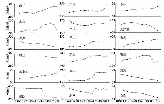
尽管耕地撂荒在过去半个多世纪呈全球性的扩散,但耕地撂荒的渐变性,复杂性和不稳定性以及空间分布的零散性等特征,使得"实际撂荒耕地"变得难以定义,识别和预测[16],采用遥感方法提取撂荒地块信息也较其他土地利用变化信息的获取更为困难.通过连续时相的遥感数据提取植被指数时间序列曲线能更有效地提取撂荒地信息[17],Alcantara等利用MODIS时序数据对中欧和东欧一带撂荒耕地进行制图,结果显示该地区2005年的耕地撂荒规模高达52.5万 km2,约为现有耕地面积的1/5[18].由于混合像元的存在[18],大范围的撂荒地解译精度不高(用户精度40%~75%),山地丘陵地区的解译精度更低[19].目前仍然没有较为准确的全球耕地撂荒数据,各国官方的相关统计数据和资料更是缺乏,仅有日本对全国耕地撂荒开展跟踪调查,显示2010年日本全国总撂荒率为10.6%[20].从现有研究来看,欧洲,美国,澳大利亚及日本等发达国家是耕地撂荒分布最为广泛的地区[3, 12],中国山区[7, 21],拉美[22],东南亚[5, 23]等部分地区也有明显耕地撂荒现象.另外,在各个国家和地区内部,耕地撂荒分布并不均衡,例如美国的耕地撂荒集中在东部[24-25],而中欧山区,地中海地区,东欧地区是欧洲耕地撂荒最为明显的地区[8, 13, 18, 26].基于历史耕地空间数据重建的估算,1700-1990年间,全球耕地撂荒面积为235万km2,绝大部分的撂荒发生在1900-1990年间[27].另一项基于HYDE 3.0和SAGE的历史耕地数据集研究测算,全球在20世纪撂荒的耕地面积为385~472万km2 [28],占全球2012年耕地面积的8%~10%左右.为更好地反映全球耕地撂荒的分布和发展过程,本文以FAO的历年农地面积数据从侧面反映耕地撂荒变化(图1).结果显示,1961-2011年间,亚洲,非洲和拉丁美洲等发展中地区的农地面积均呈现上升趋势;西欧,南欧,北美,大洋洲等发达地区的农地面积处于明显且持续减少的过程中,过去50年间共减少农地面积379万km2,而森林面积不断增加.一般认为,发达地区的森林转型由经济增长路径驱动[4, 6],农地面积的减少过程大致反映这些地区在1960以后所经历的耕地撂荒发展过程和趋势.亚洲发达国家日本和韩国也从20世纪60年代开始先后经历类似欧美发达国家的耕地收缩过程.受苏联解体的突变性影响,东欧地区的农地面积在1990s初以极其迅速的速度减少,表现出与发达国家渐进式的耕地撂荒发展过程有明显区别[29],意味着撂荒主要驱动力的不同.
 显示原图|下载原图ZIP|生成PPT
图11961-2011年世界各大洲农地面积变化(数据来源:FAO,其中南亚地区2000-2005年期间出现的农地面积急剧下降是因伊朗农地面积在2004-2005年突减所致,伊朗农地面积的突减可能与其不稳定的政治环境有关.)
-->Fig. 1Farmland area changes in all continents from 1961 to 2011
-->
3 耕地撂荒驱动力和原因
3.1 社会经济要素变化是撂荒的主要驱动力
根据现有研究,耕地撂荒驱动力基本都可归结到宏观层面的社会经济要素的变 化[30],总结归纳可分为以下几个方面:① 城镇化和工业化发展引起农村人口的外迁和非农化,导致山区农业劳动力大量减少;② 市场需求变化,国际贸易发展以及农资价格上涨等多种原因导致际土地利用纯收益下降;③ 农业相关政策调整;④ 土地制度改革;⑤ 农业技术升级和农业商品化等(表1).Tab. 1
表1
表1主要撂荒国家和地区的代表性撂荒驱动力
Tab. 1Typical drivers of farmland abandonment in main research areas
| 研究地区 | 地形 | 撂荒驱动力/原因 | 研究时间 | 文献 |
|---|---|---|---|---|
| 西班牙东北部 | 山区 | 人口减少,生计变化 | 1984-2007年 | [48] |
| 葡萄牙东南部 | 丘陵 | 欧盟共同农业政策(CAP)的实施,农村人口外迁,耕地利用边际化 | 1985-2000年 | [34] |
| 法国庇里牛斯山 | 山区 | 市场需求变化,耕地利用边际化 | 1950-2000年 | [49] |
| 法国中南部 | 山区 | 人口减少 | 1975-1998年 | [50] |
| 瑞士山区 | 山区 | 人口外迁,农户兼业化比例上升 | 1980s-1990年 | [51] |
| 俄罗斯西部 | 平原 | 社会经济体制变革,补贴停止 | 1984-2010年 | [52] |
| 阿尔巴尼亚东部 | 山区 | 大量低价农产品进口,导致农产品收益的下降,促使大规模的农民就业非农化和人口迁出 | 1988-2003年 | [53] |
| 波罗的海北部 | 平原 | 苏联解体,中央政府停止农业补贴 | 1989-1998年 | [54] |
| 喀尔巴阡山区 | 山区 | 社会经济体制变革,土地制度改革 | 1986-2000年 | [55] |
| 拉脱维亚中部 | 丘陵 | 农业劳动力缺失,土地私有化 | 1990年以后 | [56] |
| 斯洛伐克 | 山区 | 市场经济条件下进口增加导致本地农产品需求和价格的下降,引起耕地利用边际化;其他次要原因包括青年劳动力缺失,劳动力老龄化,生计多样化等. | 1990-2010年 | [57] |
| 乌克兰西部 | 山区 | 政治体制崩溃,不完全的土地制度改革,务工机会增加 | 1989-2008年 | [29,58] |
| 波兰南部 | 山区 | 农业经济转型 | 1823-2001年 | [31] |
| 美国山麓地区南部 | 山地丘陵 | 土地边际化(贫瘠土地需要大量肥料,成本过高) | 1935-1975年 | [35] |
| 泰国北部 | 山区 | 土地退化,林业承包到户政策,经济体制改革,取消粮食省内自给自足政策 | 1990s以后 | [5, 59] |
| 拉丁美洲 | 山区 | 二,三产业快速发展,农村人口外迁,农业劳动力非农化,平原地区农业现代化和规模化,国际贸易发展 | 1980s以后 | [22] |
| 波多黎各 | 山区 | 沿海地区工业化和航空业发展促进大量农业劳动力流向沿海和北美地区的非农产业部门 | 1950-1990年 | [60] |
| 智利Acud岛 | 丘陵 | 城镇化和工业化 | 1985-2007年 | [15] |
| 日本本州岛西部 | 山区 | 青年劳动力外出务工,人口减少 | 1950s-1990s | [61] |
| 菲律宾巴拉望岛 | 山区 | 沿海平原地区水田灌溉技术发展提高了复种指数,能够提供更高的工资,导致山区农民务农机会成本上升 | 1990s | [23] |
| 尼泊尔喜马拉雅 南麓 | 山区 | 交通条件改善,非农就业机会增加,农村人口大量外迁导致农业劳动力不足,家庭务工收入比重增加降低对土地依赖,边际土地比较收益偏低,土壤肥力下降,土地改革法案修正案实施妨碍土地流转 | 1970s-2000年 | [62] |
| 川西大渡河上游 | 山区 | 土地制度改革,农业劳动力外出务工,耕地利用边际化 | 1967-2000年 | [63] |
| 宁夏南部 | 山区 | 务农机会成本上升,农业劳动力析出,耕地利用边际化 | ~2008年 | [64] |
| 重庆 | 山区 | 务农机会成本上升,农业劳动力析出 | ~2010/2012年 | [21, 65] |
| 江西省 | - | 务农机会成本上升,农业劳动力析出 | 1990-2005年 | [66] |
| 贵州省毕节市 | 山区 | 农业收益低下,生产条件差,农业劳动力不足 | ~2012年 | [67] |
新窗口打开
城镇化和工业化发展被认为是许多地区耕地撂荒的最根本驱动力,尤其是在欧洲和日本等发达国家和地区[8, 31-32].二,三产业的快速发展提供了大量的收入更高且工作时间更短的岗位,务工机会增加,城乡收入和生活水平差距扩大,吸引农村地区的农业劳动力不断地转移到城镇非农部门;随着农村人口和农业劳动力减少,质量差,产出低的耕地就被撂荒[4, 30, 33].市场需求减少[34],农资价格上涨[35]以及国际贸易发展[22, 36]都会导致原有农产品价格下降或成本上升,使耕地净收益减损,推动农民脱离农业向非农产业部门转移,促进耕地撂荒.农业补贴政策增加了耕地收益,在一定程度上减缓撂荒发展[15].在欧盟国家,共同农业政策和休耕地补贴政策是影响欧洲边际土地撂荒发展的重要因素[19, 33].
不同于西欧,南欧等经济驱动原因,东欧地区的耕地撂荒主要动力来自于制度的变革.1991年苏联解体后,受前苏联影响的东欧地区的土地产权制度从公有制向私有制转变,导致大量私有化土地被没有农业生产经验或没有兴趣参与农业生产的人所获得,这不仅造成耕地权属和经营管理的联系弱化,而且还由于土地所有权碎化而增加交易成本.加上农业补贴减少甚至取消,缺乏农业技术指导,市场竞争加剧等因素影响,东欧地区农业发展严重衰退,农村失业率飙升.在城市化和工业化发展的拉动作用下,大量的农村劳动力,尤其是青年劳动力向城市转移,最终造成大量耕地撂荒[29, 37].其中,俄罗斯是受苏联解体影响而撂荒发展最为严重的国家[18].
中国土地管理制度被认为是促进耕地撂荒发生的重要原因之一.在农村社会保障制度不完善的背景下,尽管土地养老功能在减弱,但"恋土情结"使得农民宁愿撂荒也不愿意把土地流转[38].部分地区存在种粮补贴与粮食生产脱节,撂荒耕地也享受种粮补贴,降低农民种田和转出土地的积极性[39],从而增加耕地撂荒的可能.土地承包权固化客观上增加了交易成本,在一定程度上限制土地流转市场的发展[40],因此,进一步提高土地租赁的市场化程度可以有效避免优质耕地撂荒[41-42].但从另一角度来看,土地流转制度的不完善阻碍了农村劳动力转移,以及部分地区兼业经营的盛行也在某种程度上减缓了撂荒发生[43].
农业技术的发展提高了粮食单产,减少耕地需求,从而可能促使耕地发生撂荒.Rudel等发现1935-1975年间,美国南部亩产增加较快的农业县发生了边际土地撂荒,但亩产增加缓慢的农业县仍处于毁林开垦阶段[44].Mather等的耕地配置模型认为,即便没有技术进步,农民通过不断学习也可实现优质耕地利用的集约化和贫瘠土地的弃耕[45].实际上,耕地利用的集约化是一直农业的主要发展方向[46],集约度的提高促进粮食增产,在全球粮食需求不断增长的态势下,农业技术进步为耕地空间收缩提供可能,增加耕地撂荒发生的可能性.
除社会经济要素外,不合理的土地经营方式使土壤遭到严重侵蚀,导致土地质量严重退化,也会引起撂荒的发生[30],但土地退化造成的影响通常是局部的.此外,气候的变化也可能增加或降低耕地撂荒风险[16, 47]
3.2 耕地边际化是撂荒的根本原因
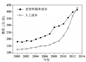
新古典经济学认为在市场经济条件下土地资源趋向于利润最大的可供选择的用途[68],所以土地利用的变化源于各种用途的可能性发生变化和比较效益的变化[69].当一块土地只有一种用途可供选择的时候,由于投入要素和产出的价格变化使得耕地的利润下降至零或者负值,亦即耕地处于无租边际以外,而且农户无论如何调整要素投入这块土地都处于无租边际外,理性的农民失去了继续经营这块土地的动力,于是耕地便会被撂荒.城镇化和工业化带来的经济发展创造了大量的非农就业机会,吸引农村人口不断向城镇迁移[7, 70];非农就业收入和机会的增加,带动农民的务农机会成本不断上升,继而造成农业劳动力价格快速上升;农业劳动力价格的上升增加了种田成本,从而压缩了农业生产利润,导致劣质耕地被边际化和撂荒[33, 66].发达国家城镇化和工业化进程中所经历的大规模耕地撂荒根本原因在于务农机会成本增加引起的耕地利用边际化[33].从根本上来说,市场需求变化[57],国际贸易发展[71],农资价格上涨[35],农业补贴减少[52],农业技术进步[23],生态保护政策[72]等因素驱动的耕地撂荒也是耕地被边际化,地租不断减少至零或以下所引起.耕地边际化是耕地撂荒发生的必要条件,但在耕地边际化过程中,如果有另外一种土地利用类型(例如林地)的地租上升,耕地就会被这种土地利用所取代,而并非一定会造成撂荒[70],例如在中国南方地区农民在边际土地改种桉树,核桃或果树等.有****认为中国在2003年左右到达刘易斯转折点[73],尽管刘易斯转折是否到来仍存争议,但中国劳动力工资水平呈现出快速上升的态势.从2003年开始,中国农民工工资每年以约10%的增速上涨[74-75],引起农业生产中劳动力成本的快速上升(图2).2003-2013年间农业劳动力的雇工工价增长了6.1倍,而种子费,化肥,农药,农膜价格和农产品售价分别增长了2.9,2.5,2.9,1.8和2.1倍,均远低于雇工工价增长速度.因此,在亩均农业生产成本中,人工成本以高于农资和服务成本的速度增长.2013年,亩均人工成本达到了430元/亩,并首次超过了农资和服务成本.劳动力成本的迅速攀升和收益的有限增长大大压缩农业生产的利润[64].为应对劳动投入成本增加带来的利润减损,农民会采取规模化,集约化耕地经营方式,利用省工性机械替代日益昂贵的农业劳动力[76-77],或增加劳动生产率较高的作物种植,达到劳动生产率最大化目的[64],从而减低由于农业劳动力价格上升带来的成本增加.然而,部分地区的耕地受制于地形等条件无法快速提高劳动生产率以减少劳动投入成本,随着劳动力成本的上升,这些地区的耕地便逐渐被边际化和撂荒[7, 33].
 显示原图|下载原图ZIP|生成PPT
图22000年以来中国三种主粮人工成本,农资和服务成本变化(数据来源:《全国农产品成本收益资料汇编》.)
-->Fig. 2Labor, materials and service costs of three main grain crops in China since 2000
-->
3.3 劳动力析出是撂荒的直接原因
农村人口的减少和农业劳动力的析出是城镇化过程中一种必然的趋势.由于农业劳动力的析出,农民必须提高劳动生产率才能维持现有耕地的经营.在务农机会成本快速上升的背景下,机械替代是提高劳动生产率最为有效的方式.然而,在边际耕地生产条件地区(例如丘陵山区),由于难以实现机械的有效替代,农户会选种植劳动力生产率高的作物,减少其他劳动投入高的作物的种植面积[64].但通过农业种植结构调整所提高劳动生产率的程度毕竟有限,劳动力在持续析出过程中最终农户无暇顾及所有土地,部分土地便被撂荒[33].由于丘陵山区的土地质量并非是同质的,农户通常按照好,中,差的顺序投入土地,相应地劣等土地边际收益将会以更大的幅度递减,从而随着劳动投入减少,劣等地首先被撂荒[72].农业劳动力析出不仅仅是劳动力数量的减少,而且还包括青年劳动力外迁引起农业劳动力老龄化所带来的农业劳动能力下降[32, 37].对于一些落后地区,经济条件改善和人们传统观念的转变提高了农村家庭对儿童教育的关注,也造成了农业劳动力的减少,成为促进耕地撂荒的原因之一.例如,在尼泊尔的喜马拉雅山南麓,5~14岁的少年儿童占当地人口总量比重超过1/5,他们曾直接或间接地参与农业生产活动,成为农业劳动力中的重要组成部分,所以,在少年儿童入学率明显升高后,耕地撂荒情况更为严重[62].因此,在劳动力不断析出的情况下,如果无法采取有效手段提高劳动生产率,部分土地将不可避免的退出生产.
3.4 耕地撂荒是多驱动力综合作用的结果
人类任何土地利用活动是发生在自然,经济和体制系统的三重相互联系和作用框架内[68],某一系统要素的变化会引起土地利用变化的同时促使其他系统要素的变化,而其他系统要素发生变化时,可能会促进或抑制这种土地利用变化的发展,亦即正反馈和负反馈过程.例如,在耕地撂荒后,森林的恢复促进野猪,野牛等野生动物的频繁活动,使农作物在收成时更容易遭受减产,这不仅增加了农业生产的风险成本,而为了驱赶野生动物防止农作物被损害,农民的劳动投入成本也大大增加,从而加速耕地边际化发展.野生动物的影响已成为了中国山区耕地撂荒的重要原因[10, 78].耕地撂荒之后可能引发的水土流失[62, 79],森林恢复之后的种子雨[51]等因素都会对农业收成带来负面影响,加大了耕地撂荒的可能性.此外,政府出台支持边际地区的发展政策,需求增长或劳动力价格上涨传导下的粮食价格上涨,新型省工性技术发展,能源作物推广种植等因素都会制约或减缓耕地边际化和撂荒的发展[7, 28, 43, 80-81].因此,耕地撂荒是经济发展,政策制度,自然因素,技术发展等多种驱动力的综合作用结果.4 耕地撂荒分布特点及影响因子
在撂荒或边际化驱动力作用下,那些阻碍耕地利用方式有效调整以适应驱动力带来的成本增加或产出减少的土地边际化影响因子,构成了撂荒风险和撂荒率空间分布差异的决定因子[10, 42, 82].撂荒影响因子的识别有助于理解耕地撂荒的形成机理,为区域土地利用格局变化模型构建和撂荒风险空间评价提供科学依据.4.1 耕地撂荒高度集中于山区
从宏观地貌单元来看,在经济社会发展水平和政策制度等条件相对一致的区域内,耕地撂荒在山区的发生率更高[21, 45].例如,日本农业部的调查数据显示,即便山区和半山区有农业直接补贴政策[83],日本山地农业区耕地撂荒率依然为平原农业区的3倍左右,半山农业区耕地撂荒率约为平原农业区的2.5倍[20].造成山地农业区耕地更容易撂荒的原因是山区存在了阻碍农业机械化和规模化发展的因素,例如地块破碎度高,坡度大,通勤距离远,交通不便等[84].因此,相对于平地,山区的坡耕地需要更多的劳动投入,额外成本增加压缩利润空间[62].中国大城市近郊耕地,因交通便利,耕作条件好,基本没有撂荒的现象,而丘陵,山区和离城较远的地区由于土地贫瘠,农业基础设施薄弱,位置偏远,耕地撂荒现象较严重[85].落后的经营方式和传统观念也是造成山区耕地撂荒概率更高的原因之一.小农式粗放化经营方式是欧洲山区主要的耕地利用方式[84],这种经营方式严重限制了技术和结构可调整空间,而且山区农民根深蒂固的传统观念使他们更难适应新的农业技术,因此撂荒风险更大[86].已有研究表明,仅东欧地区的耕地撂荒主要是发生在平原,与地形条件关系不大[87],其他地区的撂荒基本发生在山地丘陵区(表1).东欧耕地撂荒原因有其特殊性,与其土地制度和农业政策改革密切相关,因此这种发生在平原地区的耕地边际化过程可能会发生扭转.2000-2012年间,东欧地区撂荒耕地复耕面积远大于同期新增撂荒面积[19].总之,由于山区存在多种不利于耕地生产的条件,耕地撂荒可能性更高[62],撂荒后复耕的可能性也更低.
4.2 撂荒地分布受到多尺度多因素综合影响
从中观和微观尺度来看,同一地貌单元内,不同村落,不同类型农户和不同地块之间的耕地撂荒风险和程度也不相同.不少****对耕地撂荒空间分布格局影响因子进行了总结.Baumann等认为乌克兰的耕地撂荒空间分布格局主要受自然环境,地块区位,人口变化,区域农业发展水平四类因子影响[29].Gellrich等认为耕地撂荒和森林恢复出现在耕作成本高但产出低的地方,因此他将影响耕地撂荒和森林恢复分布的因素按照耕作成本和收益进行划分[51].欧盟JRC(Joint Research Center)的研究报告将欧洲地区耕地撂荒的影响因子分为三类:农业生产的自然环境适宜性,农场经济生存能力,区域社会经济条件[82].从上述总结可看出,耕地撂荒空间分布受到自然条件,劳动力特征,农业发展水平,区位条件,经济发展水平和农业政策等多方面的影响.从前文驱动力和撂荒原因分析得出,城镇化和工业化等社会经济要素变化是耕地撂荒的主要驱动力,地租下降是耕地撂荒的根本原因,留守农业劳动力能力不足是耕地撂荒的直接原因,因此,本文根据这三方面将撂荒影响因子分为三类:劳动力特征,农业生产条件和社会经济状况(表2).Tab. 2
表2
表2不同尺度上耕地撂荒的影响因素/决定因子
Tab. 2Determinants of farmland abandonment in different scales
| 空间尺度 | 劳动力特征 | 农业生产条件 | 社会经济状况 |
|---|---|---|---|
| 区域/村镇尺度 | 农业劳动力数量(-) 劳动参与率(-) 劳均耕地面积(+) 非农劳动力占比(+) 全职农场/农户比重(-) | 机械化水平(-) 平均高程(+) 平均坡度(+) 气温(~) 降水(~) 日照(~) 破碎化程度(+) 户均地块数量(+) 农田基础设施条件(-) 土壤平均质量(-) 平均通勤距离 (+) 地块到公路平均距离(±) 地块到森林边缘平均距离(-) 野生动物影响(+) 耕地平均产出(-) | 务农机会成本(+) 务工收入(+) 非农就业比重(+) 非农产业产值占比(+) 人均GDP(+) 劳动力/人口变化速率(+) 城镇化率(+) 到最近行政中心距离(±) 道路密度(+) 土地流转率(-) 农业补贴政策(-) |
| 农户/农场尺度 | 农业劳动力数量(-) 劳均耕地面积(+) 劳动力平均年龄(+) 老年劳动力比重(+) 男性劳动力比重(-) 农场主/户主年龄(+) 家庭抚养比(+) 兼业程度(+) 受教育水平(±) 农户类型 | 农业机械拥有数量(-) 地块数量(+) 地块平均面积(-) 耕作半径(+) 耕地质量(-) 耕地平均产出 (-) | 人均收入(+) 农业收入(-) 非农收入(+) 非农收入比重 (+) |
| 地块尺度 | 地块大小(-) 地块形状指数(+) 地块坡度(+) 地块高程(+) 土壤质量(-) 耕地产出 (-) 地块通勤距离(+) 地块到公路距离(±) 地块到森林边缘距离(-) |
新窗口打开
劳动力特征包括劳动力数量和质量(年龄结构,性别比例,文化程度),而家庭抚养比和劳均耕地也是影响或反映劳动力供给的指标,所以也划为这一类.劳动力数量和质量决定总劳动力能力,一般而言,农业劳动力数量越少,老龄化程度越深,男性农业劳动力比重越低,抚养比越高,全职农场/农户数量越少,农业劳动力有效数量越少,撂荒可能性越高[65, 78].劳均耕地或亩均耕地劳动力是反映劳动力资源的相对丰富程度,劳均耕地面积越多,劳动力相对稀缺,撂荒的可能性越高[42, 66, 88].不同类型农户和劳动力中,受教育水平对耕地撂荒有着不同的作用[65, 88].
农业生产条件涵盖了影响农业产出效益和投入成本的因素,包括与产出效益相关的气候因子,土壤质量,农田水利设施,地块到森林边缘距离等因子,与生产成本相关的高程,坡度,地块破碎度,通勤距离/耕作半径(耕作便捷性),机械化水平等因子.海拔高,坡度大,破碎度高,通勤距离远,土层薄,土壤质量差,积温低的耕地因劳动投入高,产出低而更容易发生撂荒[34, 51, 66, 84, 89-90].农田基础设施条件改善和机械化发展有利提高农业收益,减少劳动投入,因此有助于减少撂荒.到森林边缘越近的耕地,受到树荫和种子雨影响,农作物减产可能和减产程度越大,撂荒可能性越高[51, 66].作物单产是反映产出收益更为直接而综合的因子,它是俄罗斯西部平原地区耕地撂荒空间分布最重要的解释因子[52].
社会经济状况是反映耕地撂荒驱动力的强弱,包括城镇化和工业化发展等引起的务农机会成本上升,土地流转率和农业补贴政策.务农机会成本核算相对困难,尤其是缺少农户调查数据的情况下,通常利用其他间接指标来反映.务农机会成本与务工机会,务工工资多寡有关,在区域层面上,这些指标包括非农就业比重/农业就业比重,农村劳动力/农村人口减少比率,非农产业产值占比,城镇化率,人均GDP等[29, 51, 66].到最近行政中心距离,道路密度等也在一定程度上反映出农民外出务工成本的高低,但关联度较低[52].土地流转率既反映土地市场完善程度,也在一定程度反映土地的价值,因此,土地流转率越高,撂荒程度越低[41, 82, 91].
劳动力特征,农业生产条件和社会经济状况因素在不同尺度有不同的表现形式.村镇尺度和地块尺度的影响因素可以解释撂荒空间分布差异,撂荒地块分布规律符合杜能--李嘉图地租理论[5, 52].农户是耕地利用方式的决策单元,耕地撂荒是农户对劳动力配置的结果,因此,农户尺度研究是撂荒机理研究的重要视角[64].面对务农机会成本上升,农户会根据自身拥有的资源和资产状况,以追求家庭利益最大化为目标优化配置劳动力和耕地资源,所以不同类型农户对边际土地有不同的处理方式,且撂荒原因,程度和影响因素也不同[34, 65, 78].不同尺度上的影响因子对撂荒的贡献程度也不相当.Zhang等采用多层次回归模型的方法对多尺度的耕地撂荒影响因子进行分析,结果发现地块尺度的影响因子对耕地撂荒空间分布差异的解释能力高达80%,农户尺度和村级尺度影响因子的解释能力仅为7%和13%[42].
4.3 撂荒影响因子的区域响应不一
耕地撂荒是多尺度多因素综合作用的结果,其影响因素的复杂性导致不同地区的耕地对撂荒影响因子的响应不一,并可能导致普遍有效的撂荒指示因子失灵.例如,土地破碎化被认为是导致耕地撂荒的重要因素之一.地块小而分散不仅阻碍了机械有效替代,而且增加通勤成本,导致生产成本的增加和生产效率的低下[92-93],所以破碎度越高,撂荒可能性越大[94-95].但是,土地破碎化并不是总是导致生产效率低下的原因,它可能是农户应对经济危机和社会动荡而采取多样化的种植策略,以规避农业生产风险的结果[96].因此,有些破碎化程度越高的地区,耕地撂荒率反而越低[53].再如,耕地撂荒概率既可以是随耕地到公路距离增大而增加,也可以是随距离增大而减少.前者原因在于靠近公路可以节约运输成本和时间[58],所以距离越远,耕地撂荒发生概率越大[42, 78].后者原因在于靠近公路意味着农民外出务工的机会更多,所以距离越远,撂荒发生的概率反而越低[26].然而,从根本上来说,地块到公路的距离并不是影响撂荒分布的直接因素,因为它既无法反映真实的耕种通勤距离,也难以有效反映农民务农机会成本,而且对不同类型农业,道路作用大小也不相等[51].在乌克兰西部喀尔巴阡山区,由于山区的耕地质量优于平原以及其他因素影响,导致平原地区的撂荒率反而高于山区[29].另外,区域农业政策的存在也可能会干扰地形等主要撂荒影响因子的指示效果[10].总之,撂荒影响因素的复杂性和区域差异性决定了在选取撂荒影响因子进行撂荒风险评价或撂荒空间格局模拟的时候,必须从研究区撂荒原因着手,选择与撂荒驱动力和原因密切相关的因子.5 耕地撂荒效应
5.1 生态环境效应存在显著的区域差异
耕地停止耕种后,缺少管理的半自然人工生态系统随时间逐渐演替为自然生态系统,这不仅彻底改变了传统的农业景观,而且带来深刻的生态环境效应[8, 30, 97].目前,耕地撂荒的生态环境效应研究主要集中在生物和景观多样性,碳汇功能,土壤侵蚀和恢复,森林火灾等[30],其中关于撂荒对生物多样性影响的研究最为丰富[30, 97].案例研究表明撂荒生态效应存在明显地区差别,但目前仍存在较大争议.有观点认为耕地撂荒对半自然生境是一种威胁,某些地区的半自然生境有着较高的自然保护价值,应当维持农业生产状态[98];另一些观点认为耕地撂荒是促进自然生态系统恢复和生物多样性保护的好契机[22, 99-100].耕地撂荒对景观和生物多样性影响的争议最为激烈[12].世界农业发展历史非常悠久,粗放式的农业经营方式形成了重要的生态群落和生态系统,其物种多样性甚至超过自然植被[8].欧洲超过50%的重要生物群落生活在粗放式经营的耕地[101],这类耕地被认为具有极高的自然价值,能够促进生物多样性[102].因此,这类耕地撂荒后,农田生态系统发生自然演替,致使物种丰富的栖息地遭受破坏,具有较高保护价值的传统农业景观也发生退化[98],而原先生活在农田系统部分物种随之消失,对鸟类,节肢动物的生存威胁尤为严重[102-103],最终造成野生种群数量大量减少[104]以及生态,美学价值的下降[101]等问题.欧洲地区的案例研究持这种消极效应观点的比例更大[8, 10];日本[105],墨西哥[106]等地区的研究也认为维持传统农业生产方式和景观有利于保护濒危的物种.此外,撂荒后自然演替造成撂荒地植被均质化,不仅增加火灾风险[30, 107],而且还因促进耐火植物的生长减少生物多样性[30].
也有不少研究认为撂荒对生物多样性的积极作用更大.Navarro等质疑粗放式耕地经营方式的"环境友好性",认为耕地撂荒及森林恢复有利于促进生物多样性,并且能够增强区域的碳汇,休闲等生态服务功能,所以应该促进山区耕地撂荒和森林恢复[108].Queiroz等通过综述276篇文献发现耕地撂荒对生物多样性产生消极影响的研究主要集中在欧洲和亚洲,而南北美洲的研究更多地持相反观点,这种区域的差异主要取决于研究者关注的测度,物种和时间段[12].就物种多样性变化而言,耕地撂荒会导致适应开阔生境的物种数量减少,但会增加适应林地的物种数量[109];而且撂荒后自然恢复的植被群落其多样性指数随着退耕年限的增加而增加[110].
土地利用变化对陆地生态系统碳循环有着重要的影响.一般认为耕地撂荒之后的自然植被恢复是碳封存过程[89],农田转变为次生林可使土壤碳储量增加[111],因此土地撂荒后的森林恢复具有较大的碳汇作用,有利于改善全球生态环境[58]和温室效应.Kuemmerle等对苏联解体之后在乌克兰出现的大规模耕地撂荒和森林恢复的固碳潜力进行了评估,结果表明1988-2007年间,乌克兰的耕地撂荒及其森林扩张具有150 TgC的固碳潜力[112].Vuichard等对1991-2000年间苏联的耕地撂荒固碳潜力评估也有类似的研究结果[113].2001-2008年间中国年因生态退耕增加碳汇5.87 Mt [114].
在不同类型气候区,耕地撂荒后自然植被恢复时间差异很大[131],而植被恢复速度对土壤的影响很大.耕地撂荒之后,植被若能及时恢复将增加土壤入渗率,减少地表水流和增加土壤田间持水量[115],有效减轻土壤侵蚀和水土流失[116-117],提高土壤肥力[118].但在半干旱地区,由于植被恢复速度较慢,生物土壤结皮导致土壤下渗率降低,反而增加撂荒地地表径流[107, 119].坡耕地或梯田撂荒后管护措施缺位和放牧活动的增强,会增加地表粗糙度和地表,地下水流,因此,在短期内会加大水土流失,洪水和山体滑坡等自然灾害风险[62, 79].此外,耕地撂荒也会对土壤的微生物群落结构和生物量造成影响[120].
5.2 社会经济效应研究较薄弱
与生态环境效应研究相比,耕地撂荒的社会经济效应研究较少,而且缺乏有效的定量评估.对于耕地撂荒的社会经济影响,不同人群持不同的态度.从经济学角度来说,耕地撂荒是农民的理性选择[38, 121],但欧洲的农村居民对耕地撂荒则普遍持消极态度,认为撂荒是对土地资源的低效利用[107],相较于正在经营的耕地和林地,无论是经济价值还是美学价值撂荒地都是最低[122].耕地撂荒促使土地景观的野生化,更是使农民对这种野生环境感到陌生和无所适从[123].耕地撂荒最为直接的影响是减少农作物的播种面积,这可能会造成局地粮食产量大幅减少[124],带来撂荒发生地区的粮食短缺等问题[62, 125].但是,探讨粮食安全问题的意义更多在于国家尺度而言,所以耕地撂荒是否带来粮食安全隐患需要更广泛地探讨.例如,多个研究表明,中国大规模以坡耕地为主的退耕还林工程造成的全国粮食减产程度有限[126],总体影响程度估计只有2%~3%[125].主要原因是退耕地和撂荒地多是质量较差,产出较低的土地,所以对粮食产量的真实影响程度要比面积减少的程度要小.当然,值得注意的是,耕地撂荒只是土地边际化的一种极端形式,耕地边际化的表现还包括"双改单","水改旱",集约度下降等季节性,隐性撂荒[70],所以在讨论耕地撂荒对粮食安全影响程度的时候,从耕地利用边际化的全过程来考虑更为合理.
与土地利用转型相似,耕地利用的功能也随着社会经济发展而发生转型[127],除了生产功能外,还具有景观美学,休闲旅游,文化传承等其他功能,而且这些非生产功能的重要性日益凸显[123, 128-129].因此,耕地撂荒比较显著的消极影响是造成农业景观的退化和村庄的衰败,进而带来传统农耕文化和美学价值的流失[130]以及旅游吸引力的下降[131-132].更为不利的是,耕地边际化与农村边际化相互影响,耕地撂荒通常由于农村人口减少所引起,而耕地撂荒往往会进一步促进农村地区的边际化,形成恶性循环[10, 133],严重制约农村地区的可持续发展,以及加剧了边际地区低收入农户的贫困程度[62].
6 耕地撂荒的应对政策和措施
欧洲地区的耕地撂荒出现时间早并且发展迅速,引起各国政府和欧盟的关注.为缓解撂荒,欧洲多国出台了相关政策,其中影响最为广泛的是欧盟FLA(Less-Favoured Areas)农业发展政策,现已更名为ANC(Areas of Natural Constraint)政策.欧盟FLA农业发展政策于1970年起源法国,起初仅指偏远山区,后来逐步扩展到非山区的边际地区,是指土壤贫瘠,人口密度低,发展落后的农村地区.欧盟国家中54%的农业区划入了FLA.FLA政策的主要目的是通过财政支援,增强落后地区的农业发展能力和竞争能力,刺激农户继续耕作耕地,维护乡村景观和促进环境友好型的可持续农业体系,促进农村可持续发展[134].FLA政策的实施减少了FLA地区的耕地撂荒规模,但具体到每个国家,由于每个国家获得支援的力度不同,该政策效果国别差异甚大[135].随着农村人口的外迁,农业劳动力减少和人口老龄化,耕地撂荒成为日本农业发展面临的主要问题之一,山区和半山区的撂荒问题尤为突出[20].为了解决山区半山区农业发展问题,日本政府在2000年出台了山区半山区直接补贴政,用于阻止这些地区的农林业衰退[83].政府规定每个山区农户可以享受的补贴上限平均约8万日元/hm2(相当于欧盟一般的面积补贴两倍还多),而且制定了稻作安定经营策略,对种稻农民进行收入补贴[136].随着这一政策的出台,耕地撂荒增长趋势开始减缓,2000-2005年间,日本山区半山区的撂荒增长率降至与平原地区持平的水平[20].
在亚洲和拉丁美洲,由于人口的大量增长导致耕地扩张和森林退缩,森林面积的减少已引发了各类自然生态环境问题和灾害,重新唤起了人们对森林生态服务功能的需求,因此,土地利用政策更偏向于如何促进森林转型,避免耕地继续侵占森林.耗工性,增产性技术的发展提高了优质耕地的集约度和利润,降低农民对坡耕地的依赖,促进山区边际土地撂荒和森林恢复[22, 59].通过平原地区单产和复种指数的提高,使山区低产耕地退耕还林还草,有利于在不影响粮食安全的前提下改善中国生态环境[137].但是,由于中国人均耕地占有量少,坡耕地比重大,必须在"粮食安全与生态保护"之间建立适度平衡,切忌采取"一刀切"的措施[21].中国在2004开始取消了农业税,并增加农业补贴以提高农民种粮积极性[138],但由于农业补贴对象和标准并没有地域上的差别,无法有效减缓中国山区耕地撂荒趋势[42].
欧洲和日本的经验表明山区农业补贴能缓解耕地利用边际化,从而减缓耕地撂荒的发展速度.尽管如此,由于耕地撂荒效应存在显著的区域差异,耕地撂荒应对政策不应只考虑维持边际土地的种植状态[139],而应着眼于如何减轻耕地撂荒带来的负面影响[140].FAO曾提出要分类应对耕地撂荒的建议,Renwick等对此进行的总结,认为耕地撂荒的应对政策设计应综合考虑土地生产率和人口密度:人多地差的边际地区应采取多种经营方式(例如乡村旅游),人少地好的边际地区应当促进农业发展,人少地差的边际地区应该推进生态退耕[21, 140-141].
减缓耕地撂荒,除了出台边际地区的农业补贴或扶持政策外,还可以采取以下措施:① 提高农村土地租赁的市场化程度,提高耕地资源的配置效率,减少优质耕地的撂荒[91];② 开展土地整理,道路和农田基础设施建设,改善农业生产条件[21];③ 随着生活水平的提高,人们对食物的品质提出更高的要求,绿色有机产品更受青睐,实行农产品原产地名称保护制度可提高山区农产品价值,缓解耕地利用边际化[33, 84];④ 种植其他边际内作物,例如生物燃料作物等[28, 81].
耕地撂荒的效应研究结果会影响到区域生态保护政策和管护措施的制定[12],而撂荒效应的区域差异性要求在政策制定的时候要考虑各地撂荒的综合效应,制定合理的预防和治理措施尽量减轻耕地撂荒带来的不利影响,并对有代表性的山区农耕文化或具有较高生态价值的山区农村进行保护,采取特殊农业补贴或支持旅游发展等措施以维持生态适宜,人地和谐的农耕文化和景观,促进山区农村的可持续发展.
7 中国耕地撂荒研究展望
7.1 撂荒空间信息提取技术的开发和监测
遥感解译和农户调查是获取耕地撂荒数据两种方法.遥感技术在获取大范围的耕地撂荒信息方面有较大的优势,能较好反映耕地撂荒的整体和时空演变过程[19, 142],为区域土地利用模拟和政策制定提供重要的基础数据[140].尽管农户调查在解释耕地撂荒机理具有优势[42, 78],但难以准确地获取总体撂荒情况以及反映空间分布差异.基于农户调查所得的撂荒率很大程度受到调查户数,空间抽样调查方法和调查技术影响,在反映全局情况存在不足.由于撂荒话题的敏感性,在农户调查过程中,农民可能会少报或不报,因此调查获取的撂荒率可能低于实际撂荒率[143].当前国内的研究大部分采用农户调查方法获取耕地撂荒信息,利用遥感影像获取撂荒信息的较少[66, 144].当然,由于山区撂荒耕地地块细碎和零散,一般的遥感调查难以识别,因此,为摸清中国撂荒地规模和空间分布,亟需开展大范围多源遥感调查,尤其是开发适用于获取山区撂荒耕地信息的遥感调查技术,提高撂荒信息提取的准确度和时效性.7.2 时空模拟,趋势预测及风险评价
随着耕地撂荒趋势不断蔓延,耕地撂荒的变化趋势也引起了****们和政府的关注.不少****利用CAPRI,CLUE-s,Dyna-CLUE对欧洲地区的耕地撂荒时空变化趋势进行了模拟和预测[16, 82, 145],为欧洲地区的农业发展政策制定提供参考.当前,中国仍处于快速城镇化阶段,农村劳动力快速转移仍是一个长期趋势和过程[146],农业劳动力快速且持续减少对中国山区耕地撂荒造成有多大的影响?对哪些地区的影响程度最大?这些都是需要回答的问题.为此,需要在现状耕地撂荒发生机理分析和区域撂荒影响因子识别的基础上,构建山区耕地撂荒规模预测的统计模型和空间显性模型,对耕地撂荒规模,时空演变过程,撂荒风险程度进行模拟和评价.由于中国地域辽阔,山区范围横跨多个气候带,农业区和经济区,各地区撂荒的具体原因或决定因子可能存在明显差别,因此在预测模型构建和风险评价因子选取时,需重点考虑气候因子,种植制度,农业发展水平,土地流转程度,社会经济发展水平等地域差异因素,因而也需要通过大量的实地调研和农户调查上对各地影响耕地撂荒的关键因素进行归纳分析和判断.7.3 耕地撂荒的效应评估和政策设计
耕地撂荒是中国当前耕地变化的重要趋势,其研究的落脚点在于这种撂荒会产生怎样的效应,对生态环境和社会经济发展带来怎样的影响.耕地撂荒效应的研究结果在很大程度上决定政策和措施如何制定,究竟是促进撂荒以加快自然生态系统恢复还是应当缓解撂荒进程维持边际土地的耕种状态.因此,耕地撂荒研究的重点内容是评估耕地撂荒生态环境和社会经济效应以及这些效应的区域差异,以使耕地撂荒应对政策设计因地而异,更有针对性,并不是要一味地维持边际耕地的种植状态或使其处于放任状态.The authors have declared that no competing interests exist.
参考文献 原文顺序
文献年度倒序
文中引用次数倒序
被引期刊影响因子
| [1] | . 区域土地利用形态与其经济和社会发展阶段相对应,它随着某个区域所处的经济和社会发展阶段的变化而变化。区域土地利用转型,即区域土地利用形态在时序上的变化,它通常与经济和社会发展阶段的转型相对应。论文在划分长江沿线样带土地利用变化的区域类型基础上,结合社会经济统计数据,分析了各区段耕地和建设用地的变化。研究表明,长江沿线样带区域农村建房用地的转型基本上能反映整个样带的区域土地利用转型,且各区段所处的农村建房用地转型阶段非常明显。此外,还发现样带各区段所处的农村建房用地转型阶段与整个样带的社会经济发展水平相吻合。 . 区域土地利用形态与其经济和社会发展阶段相对应,它随着某个区域所处的经济和社会发展阶段的变化而变化。区域土地利用转型,即区域土地利用形态在时序上的变化,它通常与经济和社会发展阶段的转型相对应。论文在划分长江沿线样带土地利用变化的区域类型基础上,结合社会经济统计数据,分析了各区段耕地和建设用地的变化。研究表明,长江沿线样带区域农村建房用地的转型基本上能反映整个样带的区域土地利用转型,且各区段所处的农村建房用地转型阶段非常明显。此外,还发现样带各区段所处的农村建房用地转型阶段与整个样带的社会经济发展水平相吻合。 |
| [2] | . This paper proposes a generalised theory of the forest transition that links it with the national land use transition and forest replenishment period. It argues that the mechanisms underlying the two transitions are not identical, and that the entire forest replenishment period following the transition should be recognised as a major land use process equivalent to the national land use transition. It proposes that Mather's original model of the forest transition be modified to explicitly allow for a delay between when deforestation ends and national forest cover starts to rise. |
| [3] | . |
| [4] | . forest transition; deforestation; forest cover change; land use |
| [5] | . <h2 class="secHeading" id="section_abstract">Abstract</h2><p id="">The concept of land use transition highlights that land use change is non-linear and is associated with other societal and biophysical system changes. A transition in land use is not a fixed pattern, nor is it deterministic. Land use transitions can be caused by negative socio-ecological feedbacks that arise from a depletion of key resources or from socio-economic change and innovation that take place rather independently from the ecological system. Here, we explore whether the sources of land use transitions are mostly endogenous socio-ecological forces or exogenous socio-economic factors. We first review a few generic pathways of forest transition as identified in national case studies, and evaluate the varying ecological quality of expanding forests associated with these pathways. We then discuss possible explanatory frameworks of land use transitions. We use the case of the recent forest transition in Vietnam as an illustration. Socio-ecological feedbacks seem to better explain a slowing down of deforestation and stabilization of forest cover, while exogenous socio-economic factors better account for reforestation. We conclude by discussing the prospects of accelerating land use transitions in tropical forest countries.</p> |
| [6] | . <h2 class="secHeading" id="section_abstract">Abstract</h2><p id="">Building on the contributions of Mather and others, this paper offers an approach for developing a more comprehensive theory of the forest transition. We argue that long-run changes in forest cover in a country or region cannot be separated from the overall pattern of land use changes. Moreover, this pattern is determined by relative land values; forest cover changes over time as the value of one land use relative to the value of its competing use changes over time. However, the actual values that are used to allocate land may be far from optimal; that is, the presence of market, policy and institutional failures can distort economic and political incentives that can lead to bias in favour of one type of land use over the other, and may ultimately explain why a forest transition may be delayed unnecessarily in some countries and regions.</p> |
| [7] | 中国20世纪80年代迎来了国家土地利用形态的转型,即代表自然生态空间的森林面积降至低谷 后反转向上,代表人类干扰较强的耕地面积从扩张到收缩。这是生态状况从整体恶化向整体改善转变的最直接原因。森林转型对应着国家经济社会发展的阶段性演进 过程,存在着必然性。其直接原因,是农林交错带的农业在与森林竞争±地资源的过程中失去优势。伴随工业化和城市化的劳动力价格上升,生活水平提高带来的林 木产品需求增加。是森林竞争力提高和农业竞争力下降的经济驱动力;而转型前农业扩张引起的生态退化,则是其政策驱动力。在中国森林转型初期,政策起到了关 键的促进作用。随着城市化的加速发展,人口年龄结构向老年型转变,中国迎来了劳动力工资持续上涨的阶段。以坡耕地为代表的劳动力密集型农地利用方式,由于 难以实现机械化。劳动生产率与平原区农业的差距将越来越大.被“边际化”的可能性越来越高。这给森林面积或自然生态空间的进一步扩张提供了机会。 . 中国20世纪80年代迎来了国家土地利用形态的转型,即代表自然生态空间的森林面积降至低谷 后反转向上,代表人类干扰较强的耕地面积从扩张到收缩。这是生态状况从整体恶化向整体改善转变的最直接原因。森林转型对应着国家经济社会发展的阶段性演进 过程,存在着必然性。其直接原因,是农林交错带的农业在与森林竞争±地资源的过程中失去优势。伴随工业化和城市化的劳动力价格上升,生活水平提高带来的林 木产品需求增加。是森林竞争力提高和农业竞争力下降的经济驱动力;而转型前农业扩张引起的生态退化,则是其政策驱动力。在中国森林转型初期,政策起到了关 键的促进作用。随着城市化的加速发展,人口年龄结构向老年型转变,中国迎来了劳动力工资持续上涨的阶段。以坡耕地为代表的劳动力密集型农地利用方式,由于 难以实现机械化。劳动生产率与平原区农业的差距将越来越大.被“边际化”的可能性越来越高。这给森林面积或自然生态空间的进一步扩张提供了机会。 |
| [8] | . Agricultural abandonment reflects a post war trend in western Europe of rural depopulation to which isolated and poorer areas are most vulnerable. The commercialisation of agriculture, through technological developments, and the influence of Common Agricultural Policy have increased productivity and focused agricultural activity on more fertile and accessible land thus transforming traditional approaches to farming. In many areas this has lead to a decline in traditional labour intensive practices and marginal agricultural land is being abandoned. The problems that these trends create are particularly marked in mountain areas. The social and economic impacts of these changes have been well documented. However, the implications for environmental policy are less well recognised. This paper reviews the literature on abandonment and gives a comparative analysis of European mountain case studies to assess the environmental impacts of land abandonment and decline in traditional farming practices. It finds abandonment is widespread and that, while the influence of environmental changes is unpredictable due to environmental, agricultural and socio-economic contextual factors, abandonment generally has an undesirable effect on the environmental parameters examined. The application of agri-environment policy measures in relation to abandonment is discussed and suggestions for future policy are proposed. Copyright 2000 Academic Press |
| [9] | |
| [10] | Publication » Analysis of Farmland Abandonment and the Extent and Location of Agricultural Areas that are Actually Abandoned or are in Risk to be Abandoned. |
| [11] | . <p id="">Environmental and socio-economic changes are leading to increased levels of land abandonment worldwide. The assembly of plant communities on old fields has informed much ecological theory, which in turn has facilitated efforts at ecological restoration. The interaction of the cultivation legacy with inherent soil and vegetation characteristics will determine the dynamics of plant community assembly on old fields and indicate the level of effort required to restore historical vegetation states. The abandonment of traditional agricultural lands in some areas will create old fields that require limited or no restoration. Yet intensification of agriculture and rapid environmental change will lead to increasing numbers of old fields that show little recovery towards an historic vegetation state. The restoration of these old fields will pose significant scientific and policy challenges.</p> |
| [12] | . ABSTRACT Farmland abandonment is changing rural landscapes worldwide, but its impacts on biodiversity are still being debated in the scientific literature. While some researchers see it as a threat to biodiversity, others view it as an opportunity for habitat regeneration. We reviewed 276 published studies describing various effects of farmland abandonment on biodiversity and found that a study's geographic region, selected metrics, assessed taxa, and conservation focus significantly affected how those impacts were reported. Countries in Eurasia and the New World reported mainly negative and positive effects of farmland abandonment on biodiversity, respectively. Notably, contrasting impacts were recorded in different agricultural regions of the world that were otherwise similar in land-use and biodiversity characteristics. We showed that the conservation focus (pre- or post-abandonment) in different regions is an important factor influencing how scientists address the abandonment issue, and this may affect how land-use policies are defined in agricultural landscapes. Read More: http://www.esajournals.org/doi/abs/10.1890/120348 |
| [13] | . |
| [14] | |
| [15] | . |
| [16] | . 1.1 Background Substantial areas of the EU have been affected by agricultural abandonment and progressive loss of management over recent decades mainly as a result of declines in the viability of extensive (low input) and small-scale agriculture systems ( |
| [17] | . Agriculture is expanding and intensifying in many areas of the world, but abandoned agriculture is also becoming more widespread. Unfortunately, data and methods to monitor abandoned agriculture accurately over large areas are lacking. Remote sensing methods may be able to fill this gap though, especially with the frequent observations provided by coarser-resolution sensors and new classification techniques. Past efforts to map abandoned agriculture relied mainly on Landsat data, making it hard to map large regions, and precluding the use of phenology information to identify abandoned agriculture. Our objective here was to test methods to map abandoned agriculture at broad scales with coarse-resolution satellite imagery and phenology data. We classified abandoned agriculture for one Moderate Resolution Imaging Spectroradiometer (MODIS) tile in Eastern Europe (~1,236,000km 2 ) where abandoned agriculture was widespread. Input data included Normalized Difference Vegetation Index (NDVI) and reflectance bands (NASA Global MODIS Terra and Aqua 16-Day Vegetation Indices for the years 2003 through 2008, ~250-m resolution), as well as phenology metrics calculated with TIMESAT. The data were classified with Support Vector Machines (SVM). Training data were derived from several Landsat classifications of agricultural abandonment in the study area. A validation was conducted based on independently collected data. Our results showed that it is possible to map abandoned agriculture for large areas from MODIS data with an overall classification accuracy of 65%. Abandoned agriculture was widespread in our study area (15.1% of the total area, compared to 29.6% agriculture). We found strong differences in the MODIS data quality for different years, with data from 2005 resulting in the highest classification accuracy for the abandoned agriculture class (42.8% producer's accuracy). Classifications of MODIS NDVI data were almost as accurate as classifications based on a combination of both red and near-infrared reflectance data. MODIS NDVI data only from the growing-season resulted in similar classification accuracy as data for the full year. Using multiple years of MODIS data did not increase classification accuracy. Six phenology metrics derived with TIMESAT from the NDVI time series (2003鈥2008) alone were insufficient to detect abandoned agriculture, but phenology metrics improved classification accuracies when used in conjunction with NDVI time series by more than 8% over the use of NDVI data alone. The approach that we identified here is promising and suggests that it is possible to map abandoned agriculture at broad scales, which is relevant to gain a better understanding of this important land use change process. |
| [18] | . The demand for agricultural products continues to grow rapidly, but further agricultural expansion entails substantial environmental costs, making recultivating currently unused farmland an interesting alternative. The collapse of the Soviet Union in 1991 led to widespread abandonment of agricultural lands, but the extent and spatial patterns of abandonment are unclear. We quantified the extent of abandoned farmland, both croplands and pastures, across the region using MODIS NDVI satellite image time series from 2004 to 2006 and support vector machine classifications. Abandoned farmland was widespread, totaling 52.5 Mha, particularly in temperate European Russia (32 Mha), northern and western Ukraine, and Belarus. Differences in abandonment rates among countries were striking, suggesting that institutional and socio-economic factors were more important in determining the amount of abandonment than biophysical conditions. Indeed, much abandoned farmland occurred in areas without major constraints for agriculture. Our map provides a basis for assessing the potential of Central and Eastern Europe鈥檚 abandoned agricultural lands to contribute to food or bioenergy production, or carbon storage, as well as the environmental trade-offs and social constraints of recultivation. |
| [19] | . Farmland abandonment is a widespread land-use change in temperate regions, due to increasing yields on productive lands, conservation policies, and the increasing imports of agricultural products from other regions. Assessing the environmental outcomes of abandonment and the potential for recultivation hinges on incomplete knowledge about the spatial patterns of fallow and abandoned farmland, especially at broad geographic scales. Our goals were to develop a methodology to map active and fallow land using MODIS Normalized Differenced Vegetation Index (NDVI) time series and to provide the first European-wide map of the extent of abandoned farmland (cropland and grassland) and recultivation. We used a geographically well-distributed training dataset to classify active and fallow farmland annually from 2001 to 2012 using a Random Forests classifier and validated the maps using independent observations from the field and from satellite images. The annual maps had an average overall accuracy of 90.1% (average user's accuracy of the fallow class was 73.9%), and we detected an average of 128.7 million hectares (Mha) of fallow land (24.4% of all farmland). Using the fallow/active time series, we mapped fallow frequency and hotspots of farmland abandonment and recultivation of unused farmland. We found a total of 46.1聽Mha of permanently fallow farmland, much of which may be linked to abandonment that occurred after the dissolution of the Eastern Bloc. Up to 7.6聽Mha of farmland was additionally abandoned from 2001 to 2012, mainly in Eastern Europe, Southern Scandinavia, and Europe's mountain regions. Yet, recultivation is widespread too (up to 11.2聽Mha) and occurred predominantly in Eastern Europe (e.g., European Russia, Poland, Belarus, Ukraine, and Lithuania) and in the Balkans. We also tested the robustness of our maps in relation to different abandonment and recultivation definitions, highlighting the usefulness of time series approaches to overcome problems when mapping transient land-use change. Our maps provide, to our knowledge, the first European-wide assessment of fallow, abandoned and recultivated farmland, thereby forming a basis for assessing the environmental outcomes of abandonment and recultivation and the potential of unused land for food production, bioenergy, and carbon storage. |
| [20] | |
| [21] | . 利用SPOT-5 影像、1:1 万地形图、退耕还林和森林工程图、社会经济统计等数据,分析了重庆市石柱县耕地边际化的特征和发生原因。结果发现:① 10 年间研究区耕地边际化率16.18%,主要分布于七曜山的北部高山区和南部中山区,而且伴随农村劳动力的非农化和留守劳动力的老龄化,边际化在很大程度上还会加剧。② 海拔、地块相对村庄的分布半径和道路连接度对耕地边际化的发生影响较大。边际化率随海拔升高而增加,特别是≥1000 m集中边际化的60.88%,在坡度和地块相对村庄的分布半径上也有类似规律。③ 劳均耕地面积和务农劳均年龄是影响耕地边际化的主要因素,耕地流转和微型农机台数是从适度规模经营、提高劳动生产率上影响耕地边际化。④“比较劣势主导边际化”分布最广,占总边际化的55.32%,其次是“区位主导边际化”,占33.80%。⑤“地形主导边际化”实施类似退耕还林继续扩大的“顺边际化”政策,“区位主导边际化”从合理安排新居点、完善农村道路体系上实施“反边际化”,“比较劣势主导边际化”从提高适度规模经营、微型机械化程度上开展“反边际化”。 . 利用SPOT-5 影像、1:1 万地形图、退耕还林和森林工程图、社会经济统计等数据,分析了重庆市石柱县耕地边际化的特征和发生原因。结果发现:① 10 年间研究区耕地边际化率16.18%,主要分布于七曜山的北部高山区和南部中山区,而且伴随农村劳动力的非农化和留守劳动力的老龄化,边际化在很大程度上还会加剧。② 海拔、地块相对村庄的分布半径和道路连接度对耕地边际化的发生影响较大。边际化率随海拔升高而增加,特别是≥1000 m集中边际化的60.88%,在坡度和地块相对村庄的分布半径上也有类似规律。③ 劳均耕地面积和务农劳均年龄是影响耕地边际化的主要因素,耕地流转和微型农机台数是从适度规模经营、提高劳动生产率上影响耕地边际化。④“比较劣势主导边际化”分布最广,占总边际化的55.32%,其次是“区位主导边际化”,占33.80%。⑤“地形主导边际化”实施类似退耕还林继续扩大的“顺边际化”政策,“区位主导边际化”从合理安排新居点、完善农村道路体系上实施“反边际化”,“比较劣势主导边际化”从提高适度规模经营、微型机械化程度上开展“反边际化”。 |
| [22] | . |
| [23] | |
| [24] | . The classic story of historical land-cover change in the United States suggests that agricultural clearing in the 1800s was followed by agricultural abandonment at the turn of the twentieth century and subsequent forest regrowth - often referred to as a forest transition. Most descriptions present statistical data from historical censuses and surveys to make this case. Here we show that the his... |
| [25] | . Abstract. In order to understand the magnitude, direction, and geographic distribution of land-use changes, we evaluated land-use trends in U.S. counties during the latter half of the 20th century. Our paper synthesizes the dominant spatial and temporal trends in population, agriculture, and urbanized land uses, using a variety of data sources and an ecoregion classification as a frame of reference. A combination of increasing attractiveness of nonmetropolitan areas in the period 1970鈥2000, decreasing household size, and decreasing density of settlement has resulted in important trends in the patterns of developed land. By 2000, the area of low-density, exurban development beyond the urban fringe occupied nearly 15 times the area of higher density urbanized development. Efficiency gains, mechanization, and agglomeration of agricultural concerns has resulted in data that show cropland area to be stable throughout the Corn Belt and parts of the West between 1950 and 2000, but decreasing by about 22 % east of the Mississippi River. We use a regional case study of the Mid-Atlantic and Southeastern regions to focus in more detail on the land-cover changes resulting from these dynamics. Dominating were land-cover changes associated with the timber practices in the forested plains ecoregions and urbanization |
| [26] | . Abstract<br/>Abandonment of arable land is often assumed to happen mostly in marginal areas where the conditions for arable cultivation are relatively unfavorable, whereas arable expansion is expected to occur mostly in areas with favorable conditions. This assumption, used in many land-use change forecasts, was never properly tested, mainly because the relatively short period of full-coverage land-use inventories did not allow a systematic analysis of the phenomena. With the recent release of CORINE 2006 this has changed. In this article, we explore the typical locations of abandonment and expansion of arable land in Europe during the period 1990–2006 by means of logistic regressions. More specifically, we test whether or not locations of abandonment and expansion can be inferred from the location characteristics of arable land in 1990. If the above assumption holds, this should be the case. We demonstrate that although arable expansion indeed happens in locations that resemble the bulk of arable land in 1990 (the presumably favorable locations), arable abandonment does not necessarily happen in locations that resemble the bulk of uncultivated land (that is, the presumably unfavorable locations). In other words, the assumption does not hold. Particularly, areas close to the road network were found to be associated with both high abandonment rates and high expansion rates, which suggest that abandonment is not limited to areas that are marginal in terms of agricultural production.<br/> |
| [27] | . Baethge C, Marx C. |
| [28] | . Converting forest lands into bioenergy agriculture could accelerate climate change by emitting carbon stored in forests, while converting food agriculture lands into bioenergy agriculture could threaten food security. Both problems are potentially avoided by using abandoned agriculture lands for bioenergy agriculture. Here we show the global potential for bioenergy on abandoned agriculture lands to be less than 8% of current primary energy demand, based on historical land use data, satellite-derived land cover data, and global ecosystem modeling. The estimated global area of abandoned agriculture is 38561472 million hectares, or 6661110% of the areas reported in previous preliminary assessments. The area-weighted mean production of above-ground biomass is 4.3 tons hay, in contrast to estimates of up to 10 tons hayin previous assessments. The energy content of potential biomass grown on 100% of abandoned agriculture lands is less than 10% of primary energy demand for most nations in North America, Europe, and Asia, but it represents many times the energy demand in some African nations where grasslands are relatively productive and current energy demand is low. |
| [29] | . <h2 class="secHeading" id="section_abstract">Abstract</h2><p id="spar0015">Farmland abandonment restructures rural landscapes in many regions worldwide in response to gradual industrialization and urbanization. In contrast, the political breakdown in Eastern Europe and the former Soviet Union triggered rapid and widespread farmland abandonment, but the spatial patterns of abandonment and its drivers are not well understood. Our goal was to map post-socialist farmland abandonment in Western Ukraine using Landsat images from 1986 to 2008, and to identify spatial determinants of abandonment using a combination of best-subsets linear regression models and hierarchical partitioning. Our results suggest that farmland abandonment was widespread in the study region, with abandonment rates of up to 56%. In total, 6600 km<sup>2</sup> (30%) of the farmland used during socialism was abandoned after 1991. Topography, soil type, and population variables were the most important predictors to explain substantial spatial variation in abandonment rates. However, many of our <em>a priori</em> hypotheses about the direction of variable influence were rejected. Most importantly, abandonment rates were higher in the plains and lower in marginal areas. The growing importance of subsistence farming in the transition period, as well as off-farm income and remittances likely explain these patterns. The breakdown of socialism appears to have resulted in fundamentally different abandonment patterns in the Western Ukraine, where abandonment was a result of the institutional and economic shock, compared to those in Europe's West, where abandonment resulted from long-term socio-economic transformation such as urbanization and industrialization.</p><h4 id="secGabs_N1b2060b0N24a00940">Graphical abstract</h4><p><dl class="figure" id="fig0005"><dt ><img class="figure large" id="gabsImg" border="0" alt="Full-size image (37K)" src="http://ars.els-cdn.com/content/image/1-s2.0-S0264837710001146-fx1.jpg" data-thumbsrc="http://ars.els-cdn.com/content/image/1-s2.0-S0264837710001146-fx1.sml"></dt><dd id="labelCaptionfig0005"><p class="caption"><!--caption--></p></dd></dl> |
| [30] | ABSTRACT Agricultural activities and their complex effects on nature conservation, and the services that ecosystems deliver to humans are controversial. We present an overview of land abandonment, its driving forces and its consequences for landscape, biodiversity and humans. A descriptive meta- analysis of independently published studies highlighted the fact that the abandonment of agri- cultural land is a phenomenon mostly driven by socio-economic factors such as immigration into areas where new economic opportunities are offered to rural people. Ecological drivers such as elevation and land mismanagement leading to soil erosion are of secondary importance. We identi03ed the major problems related to abandonment of agricultural land and quanti03ed their relative importance. In order of decreasing importance, they were biodiversity loss, increase of 03re frequency and intensity, soil erosion and deserti03cation, loss of cultural and/or aesthetic values, reduction of landscape diversity and reduction of water provision. The impacts of these problems were not equally relevant in all regions of the world. The abandonment of agricultural land may also bene03t humans. The bene03ts include passive revegetation and active reforestation, water regulation, soil recovery, nutrient cycling and increased biodiversity and wilderness. In a world that is becoming less natural and more intensively exploited by humans, we suggest that (1) farmland must be viewed in a context of multi-functionality to take advantage of ecosystem goods and services, (2) at the global scale, the abandonment of agricultural land is mostly positive for humans and (3) there is a need for the implementation of policies based on the payments for environmental services that encourage human societies to reconcile agricultural use, nature conservation and ecological restoration. |
| [31] | . A study was conducted to assess the forest cover change in the Czarna Orawa watershed, Orawa region of Poland, using historical maps and contemporary satellite data. Forest cover change was analysed with reference to elevation, under the assumption that it reflects a transformation of the vertical land use system developed in the 17th and 18th centuries. For the past 180 years, the proportion o... |
| [32] | . <h2 class="secHeading" id="section_abstract">Abstract</h2><p id="">Land use has changed dramatically over the last 30–40 years throughout the Mediterranean. Much of this change has been driven by shifts in agricultural and socio-economic policy. This paper explores landscape dynamics in the SPA ‘Encinares del r??o Alberche y Cofio’ Central Spain between 1984 and 1999 in an area of approximately 83,000 ha. Categorical land cover maps, derived from three (1984, 1991 and 1999) remotely sensed Landsat images, are analyzed using a suite of landscape pattern metrics, and a simple transition matrix model of landscape change is developed. As with other landscapes in the Mediterranean a key trend is that of the abandonment of agricultural land and its subsequent succession to scrubland and woodland. Although there were significant composition changes in the landscape over the study period configurational changes are less evident. The transition matrix model suggests that there were differences in landscape dynamics between 1984–1991 and 1991–1999—most importantly an increase in the rate of land abandonment is evident. The model predicts a steady state landscape containing a higher abundance of scrubland and woodland, and a corresponding decline in pastureland and cropland. Finally, the underlying socio-economic and other drivers of landscape change in the Encinares del r??o Alberche y Cofio and some of the implications of recent changes are discussed in terms of increased wildfire risk. Sustainable management of landscapes to protect biodiversity requires the type of study described here. A necessary pre-requisite of such management activities or planning is an assessment of changes in landscape pattern and process, the social and economic pressures driving them, and their possible effects on ecosystem structure and function.</p> |
| [33] | . <h2 class="secHeading" id="section_abstract">Summary</h2><p id="">This article analyses the mechanisms behind changes in agricultural land use. Intensification of land use on the one hand, and abandonment on the other have had important consequences for landscape and biodiversity. The basic mechanism behind it is a change in the relative prices of inputs and output. In this sense the general economic developments have been determining the changes in agricultural land use. In Western Europe, the rapid increase in the opportunity costs of labour was the main factor behind mechanisation and intensification of agriculture. Also, the Common Agricultural Policy of the EU has stimulated intensification. Recent policy developments have cut down important incentives for further intensification. This, however, does not solve the problem of the decline of low input agricultural systems in Europe. The only way to maintain them is by specific nature-enhancing policies.</p><h2 class="secHeading" id="section_abstract">Zusammenfassung</h2><p id="">Dieser Artikel analysiert die Veränderungsmechanismen landwirtschaftlicher Bodenbewirtschaftung. Intensivierung von Bodenbewirtschaftung einerseits und das Wegziehen vom Land anderseits hatten bedeutende Konsequenzen für Landschaft und Biodiversität. Der Grundmechanismus dahinter ist eine Veränderung in den relativen Preisen von Inputs und Output. In diesem Sinne haben die allgemeinen wirtschaftichen Entwicklungen die Veränderungen landwirtschaftlicher Bodenbewirtschaftung bestimmt. In West-Europa war der schnelle Anstieg der Opportunitätskosten von Arbeit der Hauptfaktor hinter Mechanisierung und Intensivierung der Landwirtschaft. Auch die gemeinsame Agrarpolitik der EU hat Intensivierung stimuliert. Rezente politische Entwicklungen haben wichtige Anreize für weitere Intensivierung reduziert. Diese Tatsache jedoch löst das Problem der Abnahme landwirtschaftlicher Low-input-Syteme in Europa nicht. Der einzige Weg, diese Systeme aufrechtzuerhalten, sind spezifisch auf Natur bezogene Maßnahmen.</p> |
| [34] | . <a name="Abs1"></a>This research attempts to investigate what drives three conversions of arable land during the period 1985–2000 in a marginal agricultural landscape in Southern Portugal: afforestation of arable land, abandonment of arable land and regeneration of the agro-silvo-pastoral system. This was done by exploring the associations between these changes and a selection of both biophysical and socio-economic variables in a study area of 44 square km. For each conversion of arable land into one of the three other land use types the descriptive power of the various independent variables were evaluated using logistic regression. By comparing different statistical models (one containing only the biophysical attributes, another model containing only the socio-economic variables and finally a model containing both types of variables) the relative importance of socio-economic and biophysical variables was evaluated. The results show that both the biophysical and socio-economic variables were significantly associated with the occurrences of the land use changes. However, the models containing only the socio-economic variables were stronger related to occurrences of afforestation and regeneration of the montado, whereas the biophysical variables were more related to land abandonment. The landowner type was a significant descriptive variable across all land use change models. The results suggest that local socio-economic factors are significant in explaining the pattern of the conversion of arable land in the study area and for this reason the variety of landowners’ response to the physical conditions deserves more attention in land use change modelling. |
| [35] | . The article addresses the reforestation efforts of southern regionalists during the 1930s and 1940s in the United States. Between 1925 and 1943, the regionalists produced a series of studies of living conditions among the poor, predominantly agricultural people living in the South. Like their Chicago school contemporaries, the southern regionalists located and analyzed social facts in specific contexts. The regionalists focused on rural places, defined in ecological, geophysical, and cultural terms. In contemporary terms the southern regionalists sought sustainable development. To this end they pushed for more diverse crop mixes on southern farms. They also wanted to establish a balance between people and the land which might entail moving poor farmers off of sub-marginal lands. The regionalists emphasized the importance of naturally occurring variables like topography, soil composition, and climate in defining the way of life in a natural area. Because these variables have a direct impact on the viability of agriculture in a region, they should have an important effect on the probability of land abandonment and subsequent reforestation in a place. |
| [36] | The impact of globalization on trade, production and land use was key to the Doha development round. Although many studies have shown the positive influence of liberalization on trade and production, the environmental questions remain unanswered in most studies. Here we present a combination of an economic (Global Trade Analysis Project, GTAP) and a biophysical (IMAGE) model. The methodology is innovative as it combines state of the art knowledge from both the economic and biophysical worlds. First, the treatment of agriculture and land use is improved in the economic model. For example, information from the OECD Policy Evaluation Model (PEM) was incorporated to improve the agricultural production structure and a new land allocation methodology was introduced using regional land supply curves to facilitate the conversion of idle land to productive land while giving consideration to the level of intensification. Secondly, the adapted economic model is linked to the biophysical modeling framework IMAGE allowing feedbacks of detailed heterogeneous information on land productivity to the economic framework. While often a rather pessimistic picture is portrayed for future developments of the agricultural sector in the EU (especially in liberalizing scenarios), our results show that no drastic decrease in land for agricultural purposes is expected for the EU25 the coming 30 years, since the global food market will experience an increase in demand because of expected growth in GDP and population in many developing countries. Moreover, the negative impact of liberalization of agricultural policies on European agricultural land use is small because on the one hand loss in EU's competitiveness leads partly to extensification instead of land abandonment, and secondly, the recent agricultural reforms of the EU changed the protection from market to income support which has less production effects. Changes in land use will be more outspoken in developing countries like Africa. |
| [37] | |
| [38] | 本文从经济理论方面分析了农户 耕地撂荒行为,并对近年来我国农民从事农业生产与外出务工收益进行对比分析,剖析影响我国特殊国情下农民撂荒耕地行为的自然、经济和社会等因素。认为我国 社会经济环境对农户撂荒耕地现象的影响要远大于自然因素的影响,所以从土地利用制度、政府宏观战略调控和经济方面提出解决我国农户耕地撂荒问题的主要政策 措施。 本文从经济理论方面分析了农户 耕地撂荒行为,并对近年来我国农民从事农业生产与外出务工收益进行对比分析,剖析影响我国特殊国情下农民撂荒耕地行为的自然、经济和社会等因素。认为我国 社会经济环境对农户撂荒耕地现象的影响要远大于自然因素的影响,所以从土地利用制度、政府宏观战略调控和经济方面提出解决我国农户耕地撂荒问题的主要政策 措施。 |
| [39] | 近些年我国农业耕地抛荒现象卷土重来,呈现愈演愈烈之势,且出现一些新的特点。就土地承包者个体而言是否抛荒土地取决于其和种地的成本与收益比较,而土地抛荒是否产生资源错配,则取决于农业生产中的外部性问题。我国新一轮的土地抛荒源于农业生产中社会收益与私人收益不等所产生的外部经济问题。 近些年我国农业耕地抛荒现象卷土重来,呈现愈演愈烈之势,且出现一些新的特点。就土地承包者个体而言是否抛荒土地取决于其和种地的成本与收益比较,而土地抛荒是否产生资源错配,则取决于农业生产中的外部性问题。我国新一轮的土地抛荒源于农业生产中社会收益与私人收益不等所产生的外部经济问题。 |
| [40] | . <h2 class="secHeading" id="section_abstract">Abstract</h2><p id="">Although the importance of land rental for overall economic development and development of the non-agricultural economy has long been recognized in theory, empirical evidence on factors that can promote or impede operation of such markets and their productivity and equity impacts, especially in rapidly developing economies with rather equal land endowments, remains limited. A large household level panel is used to illustrate the large contribution of land markets to occupational diversification, productivity of land use, and household welfare. Factors affecting land market participation are derived from a household model with transaction cost and individual ability. Results suggest that, by transferring land from less able and more affluent households who joined the non-farm sector to poorer ones with ample family labor, land markets are critical not only for non-agricultural growth but, by allowing more effective use of potentially idle land can contribute to significant productivity gains. Policy implications are derived.</p> |
| [41] | . . |
| [42] | . Cropland abandonment accompanying economic development has been observed worldwide. China has experienced a large amount of land abandonment in recent years. However, the reasons for it are not entirely clear. Although abandonment decisions are made by individual households, the underlying conditions reflect processes operating at multiple levels. Therefore, we aimed to detect the influences on land abandonment at the parcel, household and village levels. We developed and employed a multi-level statistical model using farm household survey data and geographical maps of Wulong County. Our model revealed that of the variance in occurrence of land parcel abandonment, 7% and 13% can be explained at the household and village levels, respectively, while the remnant 80% can be explained at the land parcel features itself. We found that land abandonment is more prone to occur on parcels that are on steep slopes, have poor quality soil, or are remote from the laborers鈥 residences. Households with less agricultural labor per unit land area showed a high probability of land abandonment. We also found a nonlinear influence of labor age on land abandonment, with households comprising middle-aged laborers having a low land abandonment probability. Parcels in villages with high elevation, far from the county administrative center or with low prevalence of leased land are inclined to abandonment. We also found, surprisingly, that the household proportion of males among its agricultural laborers did not significantly influence the occurrence of land abandonment at the parcel level, probably due to the male agricultural laborers being overwhelmingly old (average age greater than 56 years). To alleviate land abandonment, we suggest improving land tenure and transfer security to ensure stable access to the land rental market, and also improving infrastructure in remote regions. |
| [43] | . 借鉴已有的农地边际化和森林转型的研究成果,分析了在“林进粮 退”的发展趋势下阻碍农地边际化发展的影响因素,以加深对农地边际化和森林转型的认识。结果表明,市场机制的有效性是农地边际化的后拉因素之一,主要包括 粮食交易的贸易壁垒、能源替代、省工性劳动替代、农产品价格升高等,除此之外,还有国家政策性因素、农户的社会心理行为选择也是制约农地边际化的主要后拉 因素。 . 借鉴已有的农地边际化和森林转型的研究成果,分析了在“林进粮 退”的发展趋势下阻碍农地边际化发展的影响因素,以加深对农地边际化和森林转型的认识。结果表明,市场机制的有效性是农地边际化的后拉因素之一,主要包括 粮食交易的贸易壁垒、能源替代、省工性劳动替代、农产品价格升高等,除此之外,还有国家政策性因素、农户的社会心理行为选择也是制约农地边际化的主要后拉 因素。 |
| [44] | The increase in forest cover in the southern USA during 1935-70 is described in relation to technological change in agriculture and government support programmes, and the relevance of this reforestation to the current situation in developing tropical countries is discussed. |
| [45] | . Summary A theoretical basis for the forest transition (the change from contraction to expansion of national forest area) is suggested in terms of increasing agricultural adjustment to land quality. This adjustment, operating through a process of learning by farmers, results in the concentration of agricultural production in smaller areas of better land, and the agricultural abandonment of larger areas of poorer land, which are then available for reforestation through natural regeneration or planting. |
| [46] | . Land use has generally been considered a local environmental issue, but it is becoming a force of global importance. Worldwide changes to forests, farmlands, waterways, and air are being driven by the need to provide food, fiber, water, and shelter to more than six billion people. Global croplands, pastures, plantations, and urban areas have expanded in recent decades, accompanied by large increases in energy, water, and fertilizer consumption, along with considerable losses of biodiversity. Such changes in land use have enabled humans to appropriate an increasing share of the planet's resources, but they also potentially undermine the capacity of ecosystems to sustain food production, maintain freshwater and forest resources, regulate climate and air quality, and ameliorate infectious diseases. We face the challenge of managing trade-offs between immediate human needs and maintaining the capacity of the biosphere to provide goods and services in the long term. |
| [47] | . |
| [48] | . |
| [49] | Research studies aimed at integrating socio-economic and geo-bio-physical factors are increasingly being used in order to improve our understanding of the causes and effects of land-use change and to support sustainable landscape . In line with such approaches, the study reported in this paper addresses land-use change and its drivers in the peripheral area of the Pyrenees National Park (PNP), France. The focus is land-use change on private farmland currently utilised by the farmers. The method relies on a Geographic Information System (GIS), including a digital terrain model, a digital cadastre map and a farm survey addressing current and past land use. For every parcel of land, data on current land-use practices and land-use histories since 1950 were collected during interviews with the farmers. An increase in land-use intensity occurred on some of the parcels in the late 1980s and 1990s, in contrast with the global processes of abandonment or extensification since the early 1960s. This intensification process appears to be related not only to the application of agri-environmental policies but also to specific local factors, in particular to the building of an access road to the highest part of the village. The respective roles of bio-physical factors (slope and elevation) and farm socio-economic factors (farmland spatial pattern, land-tenure system) on land-use change at parcel level have also been investigated. The impact of slope and elevation on land-use type appears overall to have been greater in 2003 than in 1950. However, these factors impact differently according to the types of landscape unit: they are not determining factors in the units remote from the village, but they do have an important role in the units close to the village. The distances of the parcels from the farmstead and their access facilities appear to be the two major farm-related factors in the local context. These results confirm the important role of land-management units' spatial arrangement in land-use dynamics and landscape change, as has already been found in other regions. They are seen as a valuable addition to studies aimed at supporting sustainable management of traditional mountain landscapes for multifunctional purposes. |
| [50] | . The example of the Massif Central, which is the largest mountain area of France, illustrates a widespread type of European mountain: those located at middle altitudes (less than 2000 m), with a past economy based almost exclusively on agriculture and which today offer restricted tourist potential. Such mountains are severely affected by depopulation which controls contemporary landscape change ... |
| [51] | Natural forest re-reflects a decline in traditional agricultural practices that can be observed worldwide. Over the last few decades, natural forest re-has replaced much of the agricultural land in the Swiss mountains. This is a region where forms of traditional cultivation have preserved unique landscapes and habitats of high ecological value. This study aimed to characterise the locations in the Swiss mountains where agricultural land has been abandoned and overgrown by trees and bushes. Therefore, multivariate statistical models based on geo-physical and socio-economic variables were developed. Land-use change data were taken from two nationwide land-use surveys carried out in the 1980s and 1990s. In order to obtain reliable models, neighbourhood effects and the group structure in our data were accounted for. For the latter a robust estimation technique known as cluster-adjustment was used. Results show that forest re-is largely restricted to former alpine pastures, land with grass and scrub vegetation and agricultural land with groups of trees at mid to high altitudes, steep slopes, stony ground and a low temperature sum. Some relationships were not as expected, e.g. many of the new forest areas were found to be relatively close to roads. A new finding from this study was that forest re-is largely restricted to regions with immigration, higher proportions of part-time farms as opposed to full-time farms and high farm abandonment rates. By accounting for neighbourhood effects, the model fit was improved. The considerable residual deviance of the models was interpreted as the result of undetected local characteristics, such as poor availability, small-scaled topographic peculiarities (e.g. small trenches, stonewalls, soil damages by ) and the individual's motivation to abandon or maintain cultivation. The conclusion made was that general policy measures for the whole mountain area are not suitable for the prevention of land abandonment and forest re-, and that policy measures must pay more attention to local characteristics and needs. |
| [52] | . The breakdown of socialism caused massive socio-economic and institutional changes that led to substantial agricultural land abandonment. The goal of our study was to identify the determinants of agricultural land abandonment in post-Soviet Russia during the first decade of transition from a state-controlled economy to a market-driven economy (1990-2000). We analyzed the determinants of agricultural land abandonment for approximately 150,550 km(2) of land area in the provinces (oblasts) of Kaluga, Rjazan. Smolensk, Tula and Vladimir in European Russia. Based on the economic assumptions of profit maximization, we integrated maps of abandoned agricultural land from five similar to 185 km x 185 km Landsat TM/ETM+ footprints with socio-economic, environmental and geographic variables, and we estimated logistic regressions at the pixel level to identify the determinants of agricultural land abandonment. Our results showed that a higher likelihood of agricultural land abandonment was significantly associated with lower average grain yields in the late 1980s and with higher distances from the nearest settlements, municipality centers, and settlements with more than 500 citizens. Hierarchical partitioning showed that the average grain yields in the late 1980s had the greatest power to explain agricultural land abandonment in our models, followed by the locational attributes of the agricultural land. We hypothesize that the termination of 90% of state subsidies for agriculture from 1990 to 2000 was an important underlying cause for the decrease of cultivation in economically and environmentally marginal agriculture areas. Thus, whereas the spatial patterns corresponded to the land rent theory of von Thunen, it was primarily the macro-scale driving forces that fostered agricultural abandonment. Our study highlighted the value of spatially explicit statistical models for studying the determinants of land-use and land-cover change in large areas. (C) 2012 Elsevier Ltd. All rights reserved. |
| [53] | . <h2 class="secHeading" id="section_abstract">Summary</h2><p id="">This paper critiques state-led strategies for land consolidation in Central and Eastern Europe. The critique builds on empirical research about the dynamics of land fragmentation and its presumable effects on cropland abandonment in Albania. Research results indicate that cropland abandonment was driven by a massive turn to non-farm opportunities, especially migration. Land fragmentation was not a rigid constraint on production but resulted from producers’ strategic risk spreading. The negotiated nature of land tenure questions the emphasis on state initiatives and administrative procedures in post-socialist land consolidation. Central and Eastern European states instead need to support desirable adaptations initiated by local communities.</p> |
| [54] | . The dramatic decay of agriculture observed, was induced by the breakdown of the Soviet state farm system, which heavily depended on huge subsidies from the central government. Our findings prove that environmental impacts caused by agriculture, like destruction of natural habitats, salinisation of soils, pasture degradation and wind erosion, have diminished considerably in the last decade, while ecological rehabilitation and the preservation of bio-diversity values are favoured by this development. This seems to apply to large areas in the southern part of the former USSR that have undergone a comparable decline of state ruled agriculture. |
| [55] | . <a name="Abs1"></a>Agricultural areas are declining in many areas of the world, often because socio-economic and political changes make agriculture less profitable. The transition from centralized to market-oriented economies in Eastern Europe and the former Soviet Union after 1989 represented major economic and political changes, yet the resulting rates and spatial pattern of post-socialist farmland abandonment remain largely unknown. Remote sensing offers unique opportunities to map farmland abandonment, but automated assessments are challenging because phenology and crop types often vary substantially. We developed a change detection method based on support vector machines (SVM) to map farmland abandonment in the border triangle of Poland, Slovakia, and Ukraine in the Carpathians from Landsat TM/ETM+ images from 1986, 1988, and 2000. Our SVM-based approach yielded an accurate change map (overall accuracy = 90.9%; kappa = 0.82), underpinning the potential of SVM to map complex land-use change processes such as farmland abandonment. Farmland abandonment was widespread in the study area (16.1% of the farmland used in socialist times), likely due to decreasing profitability of agriculture after 1989. We also found substantial differences in abandonment among the countries (13.9% in Poland, 20.7% in Slovakia, and 13.3% in Ukraine), and between previously collectivized farmland and farmland that remained private during socialism in Poland. These differences are likely due to differences in socialist land ownership patterns, post-socialist land reform strategies, and rural population density. |
| [56] | . Since land reform in the 1990s, following the restoration of Latvian independence, when land-ownership was restored to the original owners or their descendants, much of the farmland in the Vidzeme Uplands has become abandoned or is used less intensively. As a result of ecological succession, by the gradual colonisation of agricultural land by shrubs and trees, the landscape structure has changed. Initially, increased landscape heterogeneity has been observed, which may later change to become a more homogeneous landscape pattern. This paper considers the current socio-economic conditions in the area and their anticipated impact on landscape structure. |
| [57] | . Traditional agricultural landscapes (TAL) in Slovakia represents a mosaic of unique small-scale arable fields and permanent agricultural cultivations such as grasslands, vineyards and high-trunk orchards, which did not change during the collectivization of agriculture from the 1950s to the 1980s. After the change to a market-oriented economy in 1989, the management of these valuable structures decreased rapidly. The aim of this study is to investigate the distribution of TAL in Slovakia and to analyse the driving forces behind their accelerated abandonment. The study was conducted at two scales, i.e. country-wide and in three case-studies. 3013 TAL polygons encompassing 44,464ha were mapped from aerial photos, recording basic characteristics such as land-cover composition or degree of management. A detailed field study concerning the attitude of local people to the management of TAL was conducted in three case study areas. The results from the country-wide mapping shows, that 50% of the TAL area is regularly managed, 34% is partly abandoned, and 16% is abandoned. Abandonment occurs most intensively on steep slopes and on less fertile soils. The distance from settlements is important in the case of TAL with dispersed settlements and TAL with arable land and grasslands. Interviews at the case study level showed that financial profit is the main factor, which would motivate the local people to farm the TAL. Around 30% of respondents showed no interest in management. Local farmers identified the financial instruments in agriculture, in the form of unfavourable subsidies and the financial inaccessibility of modern tools and machinery as the main barriers in ideal management, together with an inadequate market and the weak support of local government. In addition, there are other cultural factors that play a role in their abandonment such as changes in the rural culture, attractivity and diversity of other ways of living, lack of successors, health and age constraints, as well as a number of persisting problems regarding unresolved land ownership in some areas. |
| [58] | . This paper uses remote sensing data from 1989 to 2000 to examine the impacts of price liberalization, land tenure, and biophysical characteristics on farmland abandonment in the border region of Poland, Slovakia, and Ukraine. Using regression analysis and matching estimators, we find that differences in biophysical characteristics, rather than in tenure systems, best explain the variation in abandonment rates within Poland. The difference in abandonment rates between Poland and Slovakia partially results from differences in land reform strategy, and abandonment in Ukraine takes a unique trajectory because of the incompleteness of the land reform and the lack of outside opportunities for residents. |
| [59] | . By Towa Tachibana, Trung M. Nguyen and Keijiro Otsuka; Agricultural Intensification versus Extensification: A Case Study of Deforestation in the Northern-Hill Region of |
| [60] | . During the past 50 years forests have recolonized extensive areas of Puerto Rico. Between 1950 and 1990 forest cover increased from 9% to 37% of the island's land area. In proportional terms more land has reverted to forest in Puerto Rico than anywhere else on earth during the second half of the twentieth century. This paper explores the geography of this process by matching changes in land cover with the characteristics of the land and communities in Puerto Rico. The reversion of agricultural lands to forest occurred most frequently in humid, upland, coffee-growing regions characterized by heavy out-migration and populations of smallholders who earned some of their income from off-farm sources. These findings suggest that changes in non-farm labor markets, as well as changes in the political economy of agriculture, have important impacts on the prospects for converting agricultural lands into forests. |
| [61] | . The landscapes of two different mountainous farm villages. Higashi-Iyayama in Shikoku and Hiwa in western Honshu, Japan, have been studied to clarify both the causes for change and the changes in landscape heterogeneity in relation to traditional land uses and the ensuing changes in land use. Until the 1950s, agriculture was the most important factor in the creation of landscape heterogeneities; grass mowing produced organic fertilizer in both villages and slash-and-burn agriculture was carried out in Higashi-Iyayama. These usages have been almost abolished over the last 40 years, owing to social changes such as depopulation. Some areas of grassland and slash-and-burn agricultural fields have been transformed into conifer plantations. Other areas have been completely abandoned and changed into deciduous forests, through the process of succession. A mosaic landscape, composed of conifer plantations and deciduous forests, has become established in the abandoned agricultural areas. |
| [62] | . ABSTRACT This paper examines the extent, causes, and consequences of abandonment of agricultural land near the village of Sikles in the Nepal Himalaya. Socioeconomic information was collected in a household survey. Abandoned agricultural land and geomorphic damage were mapped at plot level for an area of 149.6 ha. Plot-level analysis showed that nearly 49% of all khet land and 37% of all bari land had been abandoned. About 10% of all khet land had been completely damaged by landslides and floods. Nearly 41% of all abandoned plots were subjected to different forms of geomorphic damage. The amount of geomorphic damage on plots abandoned earlier is greater than that on plots abandoned recently. Abandonment of agricultural land does not automatically lead to plant colonization because geomorphic damage is intensified prior to colonization. Abandoned land requires further management for plant colonization as well as for reducing the risk of geomorphic hazards. Prevailing government policies and acts are not effective in managing abandoned land. The phenomenon of abandoned agricultural land observed in the Nepal Himalaya is not unique; it is common in many mountain areas in the world. However, this phenomenon has recently led to pronounced socioeconomic and environmental problems in Nepal. |
| [63] | . 目前常用的土地覆被分类系统没有反映植被演替过程, 不能与生态调查数据有效整合来分析区域土地覆被变化的环境效应. 文中以大渡河上游地区为例, 在4年野外考察的基础上, 依据植被演替过程对土地覆被进行详细分类, 建立了新的土地覆被分类系统, 并采用多时相数据源, 分别生成3期(1967, 1986, 2000年)土地覆被数据库,为土地利用/覆被变化、环境效应研究和生态建设提供了平台. 结果表明: (1) 土地覆被变化反映了云冷杉林采伐、自然演替和人工更新, 高山栎林和圆柏林在砍伐和放牧干扰下的大面积退化, 草甸退化、干旱河谷草地扩张、耕地撂荒和转变为果园等人为驱动的生态过程. 1967~2000年, 大渡河上游森林面积减少9.43%, 以草甸和草地、原始林和高寒灌丛为主的景观演变为草甸和草地、次生天然林、高寒灌丛、残次原始林、人工林和次生灌丛组成的景观, 景观破碎化程度加剧. (2) 大渡河上游的森林采伐迹地逐步恢复. 31年的森林采伐对象以云冷杉林为主, 其迹地仅6.86%自然演替为灌丛、草甸和草地或被开发为耕地, 其余均更新为人工林或自然演替为次生天然林, 采伐区的生态功能逐步恢复. (3) 在薪材砍伐、木炭烧制和牲畜过度放牧的驱动下, 自然恢复能力弱的高山栎林、圆柏林、亚高山草甸大面积退化,干旱河谷草地扩张, 严重削弱了区域生态屏障功能, 急需解决人为干扰问题并寻找有效的退化植被恢复途径与方法. 由于现有的天然林保护和生态重建措施忽视农牧民基本的生计问题, 要逆转干旱河谷与高山林线的植被覆盖与生态退化趋势, 关键在于帮助农牧民改变生计方式, 减轻或消除干扰压力. . 目前常用的土地覆被分类系统没有反映植被演替过程, 不能与生态调查数据有效整合来分析区域土地覆被变化的环境效应. 文中以大渡河上游地区为例, 在4年野外考察的基础上, 依据植被演替过程对土地覆被进行详细分类, 建立了新的土地覆被分类系统, 并采用多时相数据源, 分别生成3期(1967, 1986, 2000年)土地覆被数据库,为土地利用/覆被变化、环境效应研究和生态建设提供了平台. 结果表明: (1) 土地覆被变化反映了云冷杉林采伐、自然演替和人工更新, 高山栎林和圆柏林在砍伐和放牧干扰下的大面积退化, 草甸退化、干旱河谷草地扩张、耕地撂荒和转变为果园等人为驱动的生态过程. 1967~2000年, 大渡河上游森林面积减少9.43%, 以草甸和草地、原始林和高寒灌丛为主的景观演变为草甸和草地、次生天然林、高寒灌丛、残次原始林、人工林和次生灌丛组成的景观, 景观破碎化程度加剧. (2) 大渡河上游的森林采伐迹地逐步恢复. 31年的森林采伐对象以云冷杉林为主, 其迹地仅6.86%自然演替为灌丛、草甸和草地或被开发为耕地, 其余均更新为人工林或自然演替为次生天然林, 采伐区的生态功能逐步恢复. (3) 在薪材砍伐、木炭烧制和牲畜过度放牧的驱动下, 自然恢复能力弱的高山栎林、圆柏林、亚高山草甸大面积退化,干旱河谷草地扩张, 严重削弱了区域生态屏障功能, 急需解决人为干扰问题并寻找有效的退化植被恢复途径与方法. 由于现有的天然林保护和生态重建措施忽视农牧民基本的生计问题, 要逆转干旱河谷与高山林线的植被覆盖与生态退化趋势, 关键在于帮助农牧民改变生计方式, 减轻或消除干扰压力. |
| [64] | . 目前我国农业劳动力机会成本上升趋势明显。于是劳动力资源成为农业生产决策的最关键因子;农户倾向于选择劳动生产率高的土地利用类型,同时促使部分劣质土地退出农业生产(即出现农地边际化)。论文以宁夏回族自治区为例,利用统计数据和农户调查数据来验证上述推断。研究结果表明劳动力机会成本上升对农地利用变化产生明显影响。具体为:①2003年以来,宁夏劳动生产率高的农作物(马铃薯、水稻、玉米)种植面积扩大,劳动生产率低的农作物(小麦)种植面积则缩小;②农地利用结构趋于单一化;③部分劣质土地退出农业生产。 . 目前我国农业劳动力机会成本上升趋势明显。于是劳动力资源成为农业生产决策的最关键因子;农户倾向于选择劳动生产率高的土地利用类型,同时促使部分劣质土地退出农业生产(即出现农地边际化)。论文以宁夏回族自治区为例,利用统计数据和农户调查数据来验证上述推断。研究结果表明劳动力机会成本上升对农地利用变化产生明显影响。具体为:①2003年以来,宁夏劳动生产率高的农作物(马铃薯、水稻、玉米)种植面积扩大,劳动生产率低的农作物(小麦)种植面积则缩小;②农地利用结构趋于单一化;③部分劣质土地退出农业生产。 |
| [65] | . 运用参与式农村评估法、Logistic分析法,基于农户兼业活动探讨不同类型农户弃耕特点及原因,为破解生态脆弱的贫困地区农地资源低效利用问题提供参考。结果表明:①重庆市农户兼业普遍,根据非农收入比重、劳动力配置状况和生计策略,将农户划分为纯农户、I兼农户和II兼农户;②农户耕地转出行为普遍,无偿转出比重偏高。II兼农户弃耕及有偿转出比重均最高,与I兼农户相比,纯农户耕地转出的户数多,但转出面积少且多为无偿转出;旱地撂荒较水田普遍,撂荒的多为地块破碎、耕作条件差的地块;③由于家庭成员年龄偏老、劳动能力偏弱等的局限,纯农户会放弃对区位偏远、零星分散地块的耕种;I兼农户更关注土地经济收益,将资本投入到耕作条件好的地块;II兼农户主要基于收益最大化原则,倾向于将要素投入到非农产业,有偿转出耕地。研究认为,根据不同类型农户弃耕特点及原因制定相应政策措施来引导其土地利用行为,是整合区域土地资源、提高农地利用效率的有效途径。 . 运用参与式农村评估法、Logistic分析法,基于农户兼业活动探讨不同类型农户弃耕特点及原因,为破解生态脆弱的贫困地区农地资源低效利用问题提供参考。结果表明:①重庆市农户兼业普遍,根据非农收入比重、劳动力配置状况和生计策略,将农户划分为纯农户、I兼农户和II兼农户;②农户耕地转出行为普遍,无偿转出比重偏高。II兼农户弃耕及有偿转出比重均最高,与I兼农户相比,纯农户耕地转出的户数多,但转出面积少且多为无偿转出;旱地撂荒较水田普遍,撂荒的多为地块破碎、耕作条件差的地块;③由于家庭成员年龄偏老、劳动能力偏弱等的局限,纯农户会放弃对区位偏远、零星分散地块的耕种;I兼农户更关注土地经济收益,将资本投入到耕作条件好的地块;II兼农户主要基于收益最大化原则,倾向于将要素投入到非农产业,有偿转出耕地。研究认为,根据不同类型农户弃耕特点及原因制定相应政策措施来引导其土地利用行为,是整合区域土地资源、提高农地利用效率的有效途径。 |
| [66] | . Farmland abandonment has important impacts on biodiversity and ecosystem recovery, as well as food security and rural sustainable development. Due to rapid urbanization and industrialization, farmland abandonment has become an increasingly important problem in many countries, particularly in China. To promote sustainable land-use management and environmental sustainability, it is important to understand the socioeconomic causes and spatial patterns of farmland abandonment. In this study, we explored the dynamic mechanisms of farmland abandonment in Jiangxi province of China using a spatially explicit economical model. The results show that the variables associated with the agricultural products yield are significantly correlated with farmland abandonment. The increasing opportunity cost of farming labor is the main factor in farmland abandonment in conjunction with a rural labor shortage due to rural-to-urban population migration and regional industrialization. Farmlands are more likely to be abandoned in areas located far from the villages and towns due to higher transportation costs. Additionally, farmers with more land but lower net income are more likely to abandon poor-quality farmland. Our results support the hypothesis that farmland abandonment takes place in locations in which the costs of cultivation are high and the potential crop yield is low. In addition, our study also demonstrates that a spatially explicit economic model is necessary to distinguish between the main driving forces of farmland abandonment. Policy implications are also provided for potential future policy decisions. |
| [67] | . . |
| [68] | |
| [69] | . 用途转移和集约度变化构成土地利用变化的两种基本类型。土地特性自身的变化、土地使用者个体经济行为分析及社会群体土地管理行为分析 ,构成土地利用变化解释的理论框架。从土地特性考察 ,多宜性和限制性是土地利用发生变化的基本条件。人类对土地利用的结果 ,总是趋向于使土地的多宜性降低和功能类型减少。竞租曲线、转移边际点以及打破土地利用空间均衡的条件分析 ,是土地利用变化经济分析的理论基础 ;“土地利用 -环境效应 -体制响应”反馈环的作用机制 ,构成社会群体土地管理行为分析的理论框架。土地利用变化的机理模型 ,目前主要以新古典经济学和地租理论为基础。多视角的探索可能是土地利用变化机理综合分析的有效途径。 . 用途转移和集约度变化构成土地利用变化的两种基本类型。土地特性自身的变化、土地使用者个体经济行为分析及社会群体土地管理行为分析 ,构成土地利用变化解释的理论框架。从土地特性考察 ,多宜性和限制性是土地利用发生变化的基本条件。人类对土地利用的结果 ,总是趋向于使土地的多宜性降低和功能类型减少。竞租曲线、转移边际点以及打破土地利用空间均衡的条件分析 ,是土地利用变化经济分析的理论基础 ;“土地利用 -环境效应 -体制响应”反馈环的作用机制 ,构成社会群体土地管理行为分析的理论框架。土地利用变化的机理模型 ,目前主要以新古典经济学和地租理论为基础。多视角的探索可能是土地利用变化机理综合分析的有效途径。 |
| [70] | . <p>本文对农地边际化与边际土地的概念与本质、农地边际化在区域土地利用中的表现特征及其诊断标准进行了理论探讨。农地边际化是一种受社会、经济、政治和环境等因素综合驱动作用的过程,一种在现有的土地利用和社会-经济结构条件下,农地变得不再具有经济生产能力的过程。在农地边际化过程中,农户会有不同的行为响应,从而导致区域土地利用在“集约度、播种面积、用途转移与土地经营制度”等方面发生重大变化;农地利用的“边际收益指标”、“集约度指标”与“播种面积指标”是诊断农地边际化的三大指标。一般而言,如果该农地利用的“边际收益”为负,且在随后的土地利用过程中出现了“集约度下降、播种面积缩小,甚至弃耕撂荒”等变化特征,可以初步判断该农地利用出现了边际化现象。但不同类型农地边际化,其诊断标准也有差异。</p> . <p>本文对农地边际化与边际土地的概念与本质、农地边际化在区域土地利用中的表现特征及其诊断标准进行了理论探讨。农地边际化是一种受社会、经济、政治和环境等因素综合驱动作用的过程,一种在现有的土地利用和社会-经济结构条件下,农地变得不再具有经济生产能力的过程。在农地边际化过程中,农户会有不同的行为响应,从而导致区域土地利用在“集约度、播种面积、用途转移与土地经营制度”等方面发生重大变化;农地利用的“边际收益指标”、“集约度指标”与“播种面积指标”是诊断农地边际化的三大指标。一般而言,如果该农地利用的“边际收益”为负,且在随后的土地利用过程中出现了“集约度下降、播种面积缩小,甚至弃耕撂荒”等变化特征,可以初步判断该农地利用出现了边际化现象。但不同类型农地边际化,其诊断标准也有差异。</p> |
| [71] | . This article has no associated abstract. ( fix it ) |
| [72] | . <p>农地集约度下降、季节性闲置和常年撂荒是农地边际化现象之一。即使在当前惠农政策背景下,我国中部丘陵山区依然大量存在这种农地边际化现象。经过理论分析与实证,其原因如下:1.在工业化城镇化进程中,由于农业劳动存在较高的机会成本,导致丘陵山区农民非农化现象突出,农地集约利用程度下降;2.丘陵山区农业生态条件较差,农地边际收益较低;3.国家惠农政策的激励作用在丘陵山区存在相对失灵;生态政策与农业政策的不协调,对农业生产存在负外部性,从而加剧了当地的农地边际化。解决丘陵山区农地边际化问题的途径在于农业技术和组织制度的创新,改善农业生产环境,发展合作经济组织和特色农业,提高农地的边际效益;国家农业政策要因地制宜,并与生态政策协调一致。</p> . <p>农地集约度下降、季节性闲置和常年撂荒是农地边际化现象之一。即使在当前惠农政策背景下,我国中部丘陵山区依然大量存在这种农地边际化现象。经过理论分析与实证,其原因如下:1.在工业化城镇化进程中,由于农业劳动存在较高的机会成本,导致丘陵山区农民非农化现象突出,农地集约利用程度下降;2.丘陵山区农业生态条件较差,农地边际收益较低;3.国家惠农政策的激励作用在丘陵山区存在相对失灵;生态政策与农业政策的不协调,对农业生产存在负外部性,从而加剧了当地的农地边际化。解决丘陵山区农地边际化问题的途径在于农业技术和组织制度的创新,改善农业生产环境,发展合作经济组织和特色农业,提高农地的边际效益;国家农业政策要因地制宜,并与生态政策协调一致。</p> |
| [73] | . <h2 class="secHeading" id="section_abstract">Abstract</h2><p id="sp0130">In the past several years, labor shortage in China has become an emerging issue. However, there is heated debate on whether China has passed the Lewis turning point and entered a new era of labor shortage from a period of unlimited labor supply. Most empirical studies on this topic focus on the estimation of total labor supply and demand. Yet the poor quality of labor statistics leaves the debate open. In this paper, China's position along the Lewis continuum is examined though primary surveys of wage rates, a more reliable statistic than employment data. Our results show a clear rising trend of real wages rate since 2003. The acceleration of real wages even in slack seasons indicates that the era of surplus labor is over. This finding has important policy implications for China's future development model.</p><h4 id="secGabs_N1b35acd8N30fa82d8">Highlights</h4><p>? This paper examines the Lewis turning point using primary village surveys over different periods. ? Rural wage has accelerated since 2003 in both harvest and slack seasons. ? Male and female wages have experienced the same trend – slow growth prior to 2003 and a rapid increase since 2003. ? The era of surplus labor is over.</p> |
| [74] | |
| [75] | . . |
| [76] | . 利用农村固定观察点数据、《全国农产品成本收益资料汇编》、全国农业统计数据等,对近年来我国普通劳动者工资的变化特征及其对我国农地利用的影响进行了分析。结果表明:近年来我国普通劳动者工资的增长速度和幅度明显要快于农产品和农业生产资料价格的增长速度。我国东部发达地区的部分省份,其复种指数已经出现了明显的下降趋势,物质和服务投入中,省工性投入比重增加,农业种植结构向蔬菜作物和茶果园转变明显。这种趋势有逐渐蔓延全国之势。从原因上分析,主要是面对非农工资的上升,农户只有提高农业劳动生产率才能达到与非农工资匹配的目标。要保证农业生产的稳定和持续,提高农业生产效益和劳动生产率是唯一途径,其具体的政策建议是:持续增加农业补贴,继续鼓励劳动力非农迁移,以扩大农业生产规模。 . 利用农村固定观察点数据、《全国农产品成本收益资料汇编》、全国农业统计数据等,对近年来我国普通劳动者工资的变化特征及其对我国农地利用的影响进行了分析。结果表明:近年来我国普通劳动者工资的增长速度和幅度明显要快于农产品和农业生产资料价格的增长速度。我国东部发达地区的部分省份,其复种指数已经出现了明显的下降趋势,物质和服务投入中,省工性投入比重增加,农业种植结构向蔬菜作物和茶果园转变明显。这种趋势有逐渐蔓延全国之势。从原因上分析,主要是面对非农工资的上升,农户只有提高农业劳动生产率才能达到与非农工资匹配的目标。要保证农业生产的稳定和持续,提高农业生产效益和劳动生产率是唯一途径,其具体的政策建议是:持续增加农业补贴,继续鼓励劳动力非农迁移,以扩大农业生产规模。 |
| [77] | . 近年来,随着社会经济的快速发展和市场经济的不断完善,我国耕地利用中,农户利益最大化的个体追求逐步由耕地产出最大化向劳动力效益最大化方向发展,粮食生产对于农户的重要性在下降,导致我国粮食生产中耕地、资本和劳动力投入在1998年后出现下降趋势,北京、天津、上海、浙江、福建、江西、湖北、广东等省(市)区甚至出现耕地利用集约度总体下降的情况。耕地利用集约度的这一变化对我国粮食安全将产生深远的影响。文章在分析上述情况后认为,为实现我国粮食安全的国家目标,需要在耕地保护政策的基础上,进一步采取政策措施提高粮食生产的规模效益,以缓解粮食安全的国家目标与个体利益最大化的农户目标之间的冲突。 . 近年来,随着社会经济的快速发展和市场经济的不断完善,我国耕地利用中,农户利益最大化的个体追求逐步由耕地产出最大化向劳动力效益最大化方向发展,粮食生产对于农户的重要性在下降,导致我国粮食生产中耕地、资本和劳动力投入在1998年后出现下降趋势,北京、天津、上海、浙江、福建、江西、湖北、广东等省(市)区甚至出现耕地利用集约度总体下降的情况。耕地利用集约度的这一变化对我国粮食安全将产生深远的影响。文章在分析上述情况后认为,为实现我国粮食安全的国家目标,需要在耕地保护政策的基础上,进一步采取政策措施提高粮食生产的规模效益,以缓解粮食安全的国家目标与个体利益最大化的农户目标之间的冲突。 |
| [78] | . 近年来,耕地撂荒因与耕地流失及粮食安全紧密联系而备受关注。反映撂荒现状并揭示其影响因素,有利于政府制定科学的政策、规划和计划。现有的研究多将农户作为一个整体,较少考虑到不同类型农户撂荒的差异。以重庆市12 个典型村为例,在农户类型划分的基础上,分析不同类型农户撂荒的差异,运用多元线性回归模型定量分析不同类型农户撂荒的影响因素。研究表明:① 不同类型农户撂荒的差异主要体现在撂荒户数比重、户均撂荒面积、撂荒面积占承包地面积比重随耕作半径的变化情况、撂荒地现状及不同时间段撂荒面积;② 野生动物影响和人均耕地面积是影响不同类型农户撂荒的共同原因。此外,影响基本型农户的因素包括户主外出经历、耕作半径和房屋离集镇距离;影响自然资产型农户的因素包括农业劳动力比重、户主外出经历、地块平均面积和耕地收益;影响人力资产型农户的因素包括家庭人口、非农收入、耕地转出面积和耕作半径。 . 近年来,耕地撂荒因与耕地流失及粮食安全紧密联系而备受关注。反映撂荒现状并揭示其影响因素,有利于政府制定科学的政策、规划和计划。现有的研究多将农户作为一个整体,较少考虑到不同类型农户撂荒的差异。以重庆市12 个典型村为例,在农户类型划分的基础上,分析不同类型农户撂荒的差异,运用多元线性回归模型定量分析不同类型农户撂荒的影响因素。研究表明:① 不同类型农户撂荒的差异主要体现在撂荒户数比重、户均撂荒面积、撂荒面积占承包地面积比重随耕作半径的变化情况、撂荒地现状及不同时间段撂荒面积;② 野生动物影响和人均耕地面积是影响不同类型农户撂荒的共同原因。此外,影响基本型农户的因素包括户主外出经历、耕作半径和房屋离集镇距离;影响自然资产型农户的因素包括农业劳动力比重、户主外出经历、地块平均面积和耕地收益;影响人力资产型农户的因素包括家庭人口、非农收入、耕地转出面积和耕作半径。 |
| [79] | . Although accelerated rainfall runoff and soil erosion in inhabited mountain regions are often linked to cultivation practices on steep hillsides, fields that have been abandoned can pose an even greater risk of rapid runoff and soil erosion. This paper presents new evidence of land degradation resulting from land abandonment in the Ecuadorian Andes and examines the Andean case in light of recent research on land abandonment from the Pyrenees and Himalaya. The Ecuadorian data, based on 109 field rainfall simulation experiments, indicate that runoff and erosion rates on abandoned/fallow fields are significantly higher than those of cultivated lands. Analyses of total percent carbon show abandoned/fallow field soil samples to contain significantly less organic matter than those under other land uses. Continued degradation and high runoff coefficients in abandoned/fallow fields in both the Andes and the Pyrenees are linked to the ongoing, informal use of these lands for grazing. Active management strategies are required to reverse the resulting scenario of increasing land degradation. |
| [80] | . |
| [81] | . The demand for agricultural products continues to grow rapidly, but further agricultural expansion entails substantial environmental costs, making recultivating currently unused farmland an interesting alternative. The collapse of the Soviet Union in 1991 led to widespread abandonment of agricultural lands, but the extent and spatial patterns of abandonment are unclear. We quantified the extent of abandoned farmland, both croplands and pastures, across the region using MODIS NDVI satellite image time series from 2004 to 2006 and support vector machine classifications. Abandoned farmland was widespread, totaling 52.5 Mha, particularly in temperate European Russia (32 Mha), northern and western Ukraine, and Belarus. Differences in abandonment rates among countries were striking, suggesting that institutional and socio-economic factors were more important in determining the amount of abandonment than biophysical conditions. Indeed, much abandoned farmland occurred in areas without major constraints for agriculture. Our map provides a basis for assessing the potential of Central and Eastern Europe鈥檚 abandoned agricultural lands to contribute to food or bioenergy production, or carbon storage, as well as the environmental trade-offs and social constraints of recultivation. |
| [82] | |
| [83] | 2000年开始在山区半山区实施的直接补贴制度,是日本政府在WTO框架内调整农业保护方式 的最初尝试,也是日本农业保护实现从价格支持向直接补贴方式转变的转折点。直接补贴政策是依据各种土地生产条件差异而将补贴直接支付给农户,该政策不仅是 促进山区半山区农业发展的手段,也是强调农业的自然环境保护功能和强化村落集体功能的重要措施,从各种调查数据看,该制度已成为影响日本山区半山区农业发 展最重要的政策。 2000年开始在山区半山区实施的直接补贴制度,是日本政府在WTO框架内调整农业保护方式 的最初尝试,也是日本农业保护实现从价格支持向直接补贴方式转变的转折点。直接补贴政策是依据各种土地生产条件差异而将补贴直接支付给农户,该政策不仅是 促进山区半山区农业发展的手段,也是强调农业的自然环境保护功能和强化村落集体功能的重要措施,从各种调查数据看,该制度已成为影响日本山区半山区农业发 展最重要的政策。 |
| [84] | |
| [85] | |
| [86] | . The three kinds of pluriactivity are very unlike. They show that, in France, agricultural development will in future be linked to rural development to a far greater extent. |
| [87] | . Many terrestrial biomes are experiencing intensifying human land use. However, reductions in the intensity of agricultural land use are also common and can lead to agricultural land abandonment. Agricultural land abandonment has strong environmental and socio-economic consequences, but fine-scale and spatially explicit data on agricultural land abandonment are sparse, particularly in developing countries and countries with transition economies, such as the post-Soviet countries of Eastern Europe. Remote sensing can potentially fill this gap, but the satellite-based detection of fallow fields and shrub encroachment is difficult and requires the collection of multiple images during the growing season. The availability of such multi-seasonal cloud-free image dates is often limited. The goal of our study was to determine how much “missing” Landsat TM/ETM02+ images at key times in the growing season affect the accuracy of agricultural land abandonment classification. We selected a study area in temperate Eastern Europe where post-socialist agricultural land abandonment had become widespread and analyzed six near-anniversary cloud-free Landsat images from “Spring”, “Summer” and “Fall” agriculturally defined seasons for a pre-abandonment-time I (1989) and post-abandonment-time II (1999/2000). Using a factorial experiment, we tested how the classification accuracy and spatial patterns of classified abandonment changed over all possible 49 image-date combinations when mapping both “abandoned arable land” and “abandoned managed grassland”. The conditional Kappa of our best overall classification with support vector machines (SVM) was 90% for “abandoned arable land” and 72% for “abandoned managed grassland” when all six images were used for the classification. Classifications with fewer image dates resulted in a substantial decrease of the conditional Kappa (from 93 to 54% for “abandoned arable land” and from to 75 to 50% for “abandoned managed grassland”). We also observed substantial decrease in accurate detection of land abandonment patterns when we compared our best overall classification with the other 48 image date combinations (the Fuzzy Kappa, a measure of spatial similarity, ranged from 25.8 to 76.3% for “abandoned arable land” and from 30.4 to 79.5% for “abandoned managed grassland”). While the accuracy of the different abandonment classes was most sensitive to the number of image dates used for the classification, the seasons captured also mattered, and the importance of specific seasonal image dates varied between the pre- and post-abandonment dates. For “abandoned arable land” it was important to have at least one “Spring” or “Summer” image for pre-abandonment and as many images as possible for post-abandonment, with a “Spring” image again being most important. For “abandoned managed grassland” no specific seasonal image dates yielded statistically significantly more accurate classifications. The factor that influenced the accurate detection of “abandoned managed grassland” was the number of multi-seasonal image dates (the more the better), rather than their exact dates. We also tested whether SVM performed better than the maximum likelihood classifier. SVM outperformed the maximum likelihood classifier only for “abandoned arable land” and only in image-date-rich cases. Our results showed that limited image-date availability in the Landsat record placed substantial limits on the accuracy of agricultural abandonment classifications and accurately detected agricultural land abandonment patterns. Thus, we warn to use agricultural land abandonment maps produced with the sub-optimal image dates with caution, especially when the accurate rates and the patterns of agricultural land abandonment are crucial (e.g., for LULCC models). The abundance of agricultural abandonment in many parts of the world and its strong ecological and socio-economic consequences suggest that better monitoring of abandonment is necessary, and our results illustrated the image dates that were most important to accomplishing this task. |
| [88] | 我国农村土地经营制度决定了耕 地经营单位为农户家庭,耕地抛荒的决策单位是农户家庭而非农民个体,因此农户家庭成员特征对耕地抛荒会产生交互作用。在分析农户家庭成员的职业分布、年龄 分布、教育程度和收入来源对耕地抛荒影响的基础上,本文提出了"收入效用临界点"假说,并运用该假说阐述了上述特征对耕地抛荒的影响机制,认为这些特征在 耕地抛荒决策中存在的两种效应:"迁跃效应"与"涓流效应";"迁跃效应"具有突然性与爆发性等特点,而"涓流效应"具有持续性的特点。结合四川丘陵地区 9个行政村的实地调研数据,运用分位数回归验证影响耕地抛荒的"收入效用临界点"假说。研究结果表明,农户家庭特征对耕地抛荒产生不同性质、不同程度的影 响:1农业劳动力的年龄、教育程度与劳动力数量通过"涓流效应"对耕地抛荒产生不同程度的抑制作用,此外农业产出也存在抑制作用;2非农业劳动力的年龄、 教育程度、劳动力数量与非农收入比重通过"迁跃效应"对耕地抛荒产生不同程度的促进作用,同时,耕地面积对耕地抛荒也存在推动作用。最后,根据农户家庭特 征对耕地抛荒的影响性质与影响程度,本文提出了如下政策建议:注重对农户家庭成员的人力资本投资;增加农业科技投入;提高耕地对农户家庭的保障作用;进一 步完善土地流转制度。 . 我国农村土地经营制度决定了耕 地经营单位为农户家庭,耕地抛荒的决策单位是农户家庭而非农民个体,因此农户家庭成员特征对耕地抛荒会产生交互作用。在分析农户家庭成员的职业分布、年龄 分布、教育程度和收入来源对耕地抛荒影响的基础上,本文提出了"收入效用临界点"假说,并运用该假说阐述了上述特征对耕地抛荒的影响机制,认为这些特征在 耕地抛荒决策中存在的两种效应:"迁跃效应"与"涓流效应";"迁跃效应"具有突然性与爆发性等特点,而"涓流效应"具有持续性的特点。结合四川丘陵地区 9个行政村的实地调研数据,运用分位数回归验证影响耕地抛荒的"收入效用临界点"假说。研究结果表明,农户家庭特征对耕地抛荒产生不同性质、不同程度的影 响:1农业劳动力的年龄、教育程度与劳动力数量通过"涓流效应"对耕地抛荒产生不同程度的抑制作用,此外农业产出也存在抑制作用;2非农业劳动力的年龄、 教育程度、劳动力数量与非农收入比重通过"迁跃效应"对耕地抛荒产生不同程度的促进作用,同时,耕地面积对耕地抛荒也存在推动作用。最后,根据农户家庭特 征对耕地抛荒的影响性质与影响程度,本文提出了如下政策建议:注重对农户家庭成员的人力资本投资;增加农业科技投入;提高耕地对农户家庭的保障作用;进一 步完善土地流转制度。 |
| [89] | . <h2 class="secHeading" id="section_abstract">Abstract</h2><p id="">In many European mountain regions, agricultural land abandonment and the related consequences for the environment are issues of increasing concern. During the last few decades, natural forest re-growth has steadily replaced agricultural land in the Swiss mountains. This is a region where forms of traditional cultivation have preserved unique landscapes and habitats of high ecological value. The aim of this study was to investigate the recent regional-scale pattern of agricultural land abandonment, as indicated by forest re-growth, in the Swiss mountains. For this, we developed multivariate spatial statistical models on the basis of mountain-wide land-use change data, evaluated between the 1980s and 1990s, and selected geo-physical and socio-economic variables. Results show that regions with shallow soils, steep slopes and under-developed road infrastructure were favoured in terms of land abandonment and forest re-growth. These regions were also characterised by low proportions of full-time farms. In some regions, strong labour markets were related to higher abandonment rates, but this is not a general trend in Swiss mountainous regions. We found no relationship between land abandonment and migration, which contrasts with findings in other European mountain regions. One model suggests a spatial ‘spillover’ effect, causing similar abandonment rates in adjacent regions, although this could not be proven in this study. We conclude that decision-makers should consider non-linearity in the pattern of land abandonment and the fact that part-time farming is related to land abandonment when designing measures to react to land abandonment and its consequences.</p> |
| [90] | . The study discusses the tempo of the fragmentation process, which accelerates exponentially in countries with the equal inheritance system. It goes on to discuss defragmentation, social impacts of the dominance of the land rental market, and environmental impacts of significant homogenization of the land-use pattern. The serious negative impacts of extreme land-ownership fragmentation show that this phenomenon can be considered as a significant form of land degradation. |
| [91] | . <p>耕地撂荒是目前山区发展较快的一种土地利用变化,耕地流转能否缓解这一过程,促进土地资源有效配置,以避免耕地资源浪费,是一个值得探讨的课题。借助前期研究成果,使用多视角两因素散点分析和单因素相关分析方法,旨在查明山区耕地流转对缓解耕地撂荒的作用,结果表明:① 在村级尺度上,样区耕地流转与耕地撂荒间呈现显著负相关关系,流转率高的村庄,撂荒率低,尤其在优等耕作条件的耕地中表现更为突出,说明耕地流转可以减少优等耕作条件的耕地撂荒;② 在地块尺度上,优等耕作条件的耕地撂荒率显著低于劣等耕作条件,样区耕地的撂荒主要由Ⅳ等耕作条件的耕地所贡献;③ 在村级尺度上,样区耕作条件对耕地撂荒率的作用较弱,村样本间耕作条件对撂荒率差异的解释能力不强,优等耕作条件的耕地撂荒仍然存在,说明以耕地流转率代表的土地租赁市场尚不发育;④ 但是,样区耕地流转率高的村庄,优等耕作条件的耕地撂荒率低,说明耕地撂荒仍然受到土地租赁市场的完善程度所左右,且土地租赁市场在优化耕地资源利用方面的作用已有一定程度的显现;⑤ 进一步完善土地租赁的市场化程度,有助于减少或降低耕地撂荒现象的发生,可以避免优等耕作条件的耕地浪费。</p> . <p>耕地撂荒是目前山区发展较快的一种土地利用变化,耕地流转能否缓解这一过程,促进土地资源有效配置,以避免耕地资源浪费,是一个值得探讨的课题。借助前期研究成果,使用多视角两因素散点分析和单因素相关分析方法,旨在查明山区耕地流转对缓解耕地撂荒的作用,结果表明:① 在村级尺度上,样区耕地流转与耕地撂荒间呈现显著负相关关系,流转率高的村庄,撂荒率低,尤其在优等耕作条件的耕地中表现更为突出,说明耕地流转可以减少优等耕作条件的耕地撂荒;② 在地块尺度上,优等耕作条件的耕地撂荒率显著低于劣等耕作条件,样区耕地的撂荒主要由Ⅳ等耕作条件的耕地所贡献;③ 在村级尺度上,样区耕作条件对耕地撂荒率的作用较弱,村样本间耕作条件对撂荒率差异的解释能力不强,优等耕作条件的耕地撂荒仍然存在,说明以耕地流转率代表的土地租赁市场尚不发育;④ 但是,样区耕地流转率高的村庄,优等耕作条件的耕地撂荒率低,说明耕地撂荒仍然受到土地租赁市场的完善程度所左右,且土地租赁市场在优化耕地资源利用方面的作用已有一定程度的显现;⑤ 进一步完善土地租赁的市场化程度,有助于减少或降低耕地撂荒现象的发生,可以避免优等耕作条件的耕地浪费。</p> |
| [92] | . A hybrid plasmid, TpIF319, has been shown to contain the sequence for human fibroblast interferon mRNA [Taniguchi, T., Sakai, M., Fujii-Kuriyama, Y., Muramatsu, M., Kobayashi, S. & Sudo, T. (1979) Proc. Jpn. Acad. 55, Ser. B, 464-469]. This conclusion was confirmed by a hybridization-translation assay, using rabbit globin mRNA and its cDNA-containing plasmid as a control. Plasmid TpIF319 was used as probe and another recombinant plasmid, TpIF319-13, whose cDNA insert consists of about 800 base pairs, was isolated. Nucleotide sequence analysis of the cDNA revealed that the DNA in fact codes for human fibroblast interferon. |
| [93] | ABSTRACT iv, 39 p. The 1945 agrarian reform in Albania changed the distribution of landownership. The land of the largest landlords was distributed to 70,000 families who either did not own any land or owned very little. Since this agrarian reform, land tenure structures have continually changed according to the organizational form of the agricultural sector. In the early 1990s, when the centralized economy was transformed into a market economy, landownership also had to change. Through the application of a 1991 law, approximately 383,000 families received about 500,000 hectares from the ex-cooperatives. In 1992, state-farm workers' families obtained the state-farm land. As a result of privatization, 480,000 farms were created. Land fragmentation is a relatively new phenomenon in Albania, but when privatization of agricultural land was concluded each family had a farm holding that was fragmented into many different parcels. Land fragmentation in Albania appears to be a spatial and territorial phenomenon, which means subdivision into many parcels of farmland that cannot support rational utilization of land. This paper concerns land fragmentation and consolidation in Albania after land privatization. The objectives of the paper are to provide information on the level of land fragmentation in the districts included in this study, determine the impacts of land fragmentation, explore methods of land consolidation based on both Albanian and foreign experience, and disseminate the information and conclusions throughout the country. |
| [94] | . Land abandonment is an important cause of changes in landscape patterns in the Mediterranean area. There is a need to monitor land use and land cover changes in order to provide quantitative evidence of the relationship between land abandonment and the formation of new landscape patterns. Appropriate management policies to encourage sustainable development can then be developed. This paper describes how to monitor landscape dynamics using different temporal land use and land cover data generated from field survey and airborne information. The results showed that the abandonment of agricultural land generally results in an increase of vegetation biomass. This process leads to homogenization of the landscape. In addition, abandonment promotes fragmentation of agricultural land. Based on these results, the paper discusses the implications for rural management policies concerning the abandonment of agricultural land and suggests recommendations for the development of such policies. |
| [95] | . We analyze the factors driving land use within and outside riparian zones in four small (about 800ha) watersheds in Brittany. The results show a difference between riparian and non-riparian zones (less used for grassland), but other factors are also important, such as field size or farm management type. In large farms, small fields are easily abandoned. A multivariate analysis with farm and field characteristics explains 30% of land use variation. Our results suggest that farm type deflects land use from the regional mode, so it is important, in the implementation of environmental zoning, to assess constraints at the farm level. |
| [96] | . Albania’s radical farmland distribution is credited with averting an economic crisis and social unrest during the transition. But many believe it led to a holding structure too fragmented to be efficient, and that public efforts to consolidate plots are needed to lay the foundation for greater rural productivity. Farm-level data from the 2005 Albania LSMS allow us to explore this quantitatively. We find no support for the argument that fragmentation reduces productivity. However, producers fail to utilize about 10% of the country’s productive land, and this land has, in the majority of cases, been idle for at least 502years. Farmers quote inefficiently-small plots as the reason for this in very few cases, casting doubt on the scope for land consolidation to solve this issue. Instead, the data are consistent with the notion of land market imperfections, which can be traced to gaps in the legal and policy framework, as well as inefficiencies in registry operations, leading to land abandonment on a large scale. To maintain the productive potential of Albania’s rural economy and, if and when needed, the ability to conduct consolidation in a cost-effective and sustainable manner, it will be critical to complement the emphasis on consolidation with an effort to address those gaps and inefficiencies on a priority basis. |
| [97] | Studies in animals have shown that the amygdala receives highly processed visual input, contains neurons that respond selectively to faces, and that it participates in emotion and social behaviour. Although studies in epileptic patients support its role in emotion, determination of the amygdala's function in humans has been hampered by the rarity of patients with selective amygdala lesions. Here, with the help of one such rare patient, we report findings that suggest the human amygdala may be indispensable to: (1) recognize fear in facial expressions; (2) recognize multiple emotions in a single facial expression; but (3) is not required to recognize personal identity from faces. These results suggest that damage restricted to the amygdala causes very specific recognition impairments, and thus constrains the broad notion that the amygdala is involved in emotion. |
| [98] | . Abstract Top of page Abstract Introduction Acknowledgments References Many traditional farming landscapes have high conservation value. Conservation policy in such landscapes typically follows a “preservation strategy,” most commonly by providing financial incentives for farmers to continue traditional practices. A preservation strategy can be successful in the short term, but it fails to acknowledge that traditional farming landscapes evolved as tightly coupled social–ecological systems. Traditionally, people received direct benefits from the environment, which provided a direct incentive for sustainable land use. Globalization and rural development programs increasingly alter the social subsystem in traditional farming landscapes, whereas conservation seeks to preserve the ecological subsystem. The resulting decoupling of the social–ecological system can be counteracted only in part by financial incentives, thus inherently limiting the usefulness of a preservation strategy. An alternative way to frame conservation policy in traditional farming landscapes is a “transformation strategy.” This strategy acknowledges that the past cannot be preserved, and assumes that direct links between people and nature are preferable to indirect links based on incentive payments. A transformation strategy seeks to support community-led efforts to create new, direct links with nature. Such a strategy could empower rural communities to embrace sustainable development, providing a vision for the future rather than attempting to preserve the past. |
| [99] | . Despite continued forest conversion and degradation, forest cover is increasing in countries across the globe. New forests are regenerating on former agricultural land, and forest plantations are being established for commercial and restoration purposes. Plantations and restored forests can improve ecosystem services and enhance biodiversity conservation, but will not match the composition and structure of the original forest cover. Approaches to restoring forest ecosystems depend strongly on levels of forest and soil degradation, residual vegetation, and desired restoration outcomes. Opportunities abound to combine ambitious forest restoration and regeneration goals with sustainable rural livelihoods and community participation. New forests will require adaptive management as dynamic, resilient systems that can withstand stresses of climate change, habitat fragmentation, and other anthropogenic effects. |
| [100] | . |
| [101] | . 1. The historical role of agriculture in creating semi-natural vegetation is still not fully appreciated by many ecologists, conservationists, policy-makers or the general public. Nor is the fact that for many European landscapes and biotopes of high nature conservation value, the only practicable, socially acceptable and sustainable management involves the continuation of low-intensity farming. Consequently, too much emphasis is placed on attempting to ameliorate damaging effects of agricultural management rather than supporting ecologically sustainable low-intensity farming practices. 2. More than 50% of Europe's most highly valued biotopes occur on low-intensity farmland. However, most of this farmland has no environmental policy directly affecting it; most management decisions are taken by farm businesses and determined primarily by European and national agricultural officials. As a result, there continues to be intensification or abandonment of traditional practices, changes which are equally damaging to the nature conservation value. 3. However, the nature conservation importance of low-intensity farming systems is gradually being recognized. Reforms and reviews of agriculture policy are providing a variety of potential opportunities for maintaining such systems. Unfortunately, initiating change through policy is a slow process. There is therefore also a pressing need to look for other opportunities to maintain surviving systems and, where possible, to reinstate those recently lost. 4. Although these systems may be considered low-intensity in terms of chemical inputs and productivity, they are usually high-intensity in terms of human labour. Therefore, the processes that make the low-intensity farmed countryside biologically rich and diverse must be understood, but at the same time mechanisms to make life easier and more rewarding for the people who work such farmland must be found. 5. Ecologists and conservationists should think less of 'remnants of habitat being left amongst farmland' and more of a farmland biotope for which optimum management practices need to be developed. At the same time the current emphasis on site-based conservation should be complemented by strategic initiatives that promote wise management of the wider countryside. |
| [102] | . Summary Top of page Summary Introduction Materials and methods Results Discussion Acknowledgements References Supporting Information 1. 68Farmland biodiversity continues to decline mainly because of agricultural intensification and land abandonment. Agri-environment schemes can be designed to halt this loss by favouring extensification of agricultural practices and through sympathetic management of field boundaries and fallow land. In Europe, High Nature Value (HNV) farmland is defined as low-intensity farmland supporting or associated with a high rate of biodiversity, in terms of species richness or habitat diversity and therefore plays a crucial role in the maintenance of European biodiversity. However, no large-scale analysis has explored the role of these areas in achieving conservation goals. 2. 68We analysed information from widely used indicators in order to describe the impact of low-intensity agriculture on farmland biodiversity in France. We used the HNV farmland indicator, based on agricultural statistics such as the Farm Structure Survey and the grassland survey, and common bird indicators, i.e. the Farmland Bird Indicator (FBI), the Community Specialization Index (CSI) and species richness indexes, based on the French Breeding Bird Survey. 3. 68Temporal trends in the farmland bird indicator showed that populations of farmland birds were more likely to increase inside HNV areas compared to non-HNV areas. Although species richness is not higher within HNV farmland, bird communities are composed by more specialist species than in non-HNV areas. In addition, these specialist bird species are significantly more abundant in HNV areas. 4. 68 Synthesis and applications . Further farmland biodiversity decline is potentially reversible through an appropriate management of HNV areas. Existing and future agri-environment schemes should focus on preserving and extending HNV farmland, by favouring the maintenance of low-intensity agriculture and landscape complexity. Priority should be given to preserving diversity at the community level, with the help of adequate indicators, such as the ones presented here. The role of HNV farmland or similar concepts in combining agriculture and biodiversity goals should be further analysed and further used as large-scale conservation tools. |
| [103] | . Green alder is a widespread shrub species in the Alps. The intense grazing practices of the last centuries relegated it to avalanche tracks on wet and steep slopes. However, it is currently colonizing abandoned meadows and pastures on relatively wet and drained soils at the subalpine and the montane belts, creating a dense shrub cover. The aim of this study is to assess the biodiversity changes induced during alder expansion by taxonomic and functional traits, using two representative taxa, i.e. vegetation and arthropods. The results show that the alder expansion strongly affects the 0.5-1m vegetation layer and the plant species richness as well as the biomass and composition of the arthropods active on the soil surface. Hymenoptera, Orthoptera and Coleoptera, which compose the major part of the arthropod biomass, decline significantly as the green alder canopy grows. Such changes in specific and functional diversity may have strong effects on the ecosystem functioning and particularly on the maintenance of the habitat of several endangered species such as the black grouse (Tetrao tetrix L.). The impact of green alder on biodiversity must be taken into account as well as its functional role in the ecosystem before leading any management against its expansion. |
| [104] | . Although arable landscapes have a long history, environmental problems have accelerated in recent decades. The effects of these changes are usually externalised, being greater for society as a whole than for the farms on which they operate, and incentives to correct them are therefore largely lacking. Arable landscapes are valued by society beyond the farming community, but increased mechanisation and farm size, simplification of crop rotations, and loss of non-crop features, have led to a reduction in landscape diversity. Low intensity arable systems have evolved a characteristic and diverse fauna and flora, but development of high input, simplified arable systems has been associated with a decline in biodiversity. Arable intensification has resulted in loss of non-crop habitats and simplification of plant and animal communities within crops, with consequent disruption to food chains and declines in many farmland species. Abandonment of arable management has also led to the replacement of such wildlife with more common and widespread species. Soils have deteriorated as a result of erosion, compaction, loss of organic matter and contamination with pesticides, and in some areas, heavy metals. Impacts on water are closely related to those on soils as nutrient and pesticide pollution of water results from surface runoff and subsurface flow, often associated with soil particles, which themselves have economic and ecological impacts. Nitrates and some pesticides also enter groundwater following leaching from arable land. Greatest impacts are associated with simplified, high input arable systems. Intensification of arable farming has been associated with pollution of air by pesticides, NOand CO, while the loss of soil organic matter has reduced the system s capacity for carbon sequestration. International trade contributes to global climate change through long distance transport of arable inputs and products. The EU Rural Development Regulation (1257/99) provides an opportunity to implement measures for alleviating ecological impacts of arable management through a combination of cross-compliance and agri-environment schemes. To alleviate the problems described in this paper, such measures should take account of opportunities for public/private partnerships and should integrate social, cultural, economic and ecological objectives for multifunctional land use. |
| [105] | . is a traditional agricultural landscape in Japan. It contains many kinds of organisms, including endangered species.is composed of several habitat types, including paddy fields, secondary forests, secondary grasslands, ponds, and streams. High species richness has been sustained in most habitats by anthropogenic disturbances of intermediate impact, mainly activities related to agriculture. The variety of habitats and connectivity among them have contributed to the high species diversity within. These factors allow organisms to move among habitats and use different habitat types to obtain different resources. The connectivity among habitats is often more vulnerable than the specific habitats themselves under anthropogenic influences. In, species that require connectivity among habitats (e.g., grey-faced buzzard [] and Genji firefly []) have tended to decrease. The grey-faced buzzard is categorized as a “vulnerable” species in the Japanese Red List. It usually nests in forest trees and forages in habitats such as paddy fields, grasslands, and forests. Its foraging locations shift seasonally depending on food availability. It is thought that the degradation of either paddy fields or forests in a landscape may result in the disappearance of this species. The Genji firefly spends its larval period in stream water, pupates underground along streams, and flies near streams after emergence. This species requires not only the integrity of streams and nearby areas, but also connectivity between these areas. The ecology of these species suggests that the variety of habitats and connectivity among them are critical factors for their survival. |
| [106] | . |
| [107] | . <a name="Abs1"></a>In mountainous Mediterranean regions, land abandonment processes in past decades are hypothesized to trigger secondary vegetal succession and homogenization, which in recent years has increased the size of burned areas. We conducted an analysis of temporal changes in landscape vegetal spatial pattern over a 15-year period (1984–1998) in a rural area of 672.3 km<sup>2</sup> in Eastern Spain to investigate the relationship between local landscape heterogeneity and wildfire occurrence. Heterogeneity was analyzed from textural metrics derived from non-classified remote sensing data at several periods, and was related to wildfire history in the study area. Several neural network models found significant relationships between local spatial pattern and future fire occurrence. In this study, sensitivity analysis of the texture variables suggested that fire occurrence, estimated as probability of burning in the near future, increased where local homogeneity was higher. |
| [108] | . Abstract<br/>For millennia, mankind has shaped landscapes, particularly through agriculture. In Europe, the age-old interaction between humans and ecosystems strongly influenced the cultural heritage. Yet European farmland is now being abandoned, especially in remote areas. The loss of the traditional agricultural landscapes and its consequences for biodiversity and ecosystem services is generating concerns in both the scientific community and the public. Here we ask to what extent farmland abandonment can be considered as an opportunity for rewilding ecosystems. We analyze the perceptions of traditional agriculture in Europe and their influence in land management policies. We argue that, contrary to the common perception, traditional agriculture practices were not environmentally friendly and that the standards of living of rural populations were low. We suggest that current policies to maintain extensive farming landscapes underestimate the human labor needed to sustain these landscapes and the recent and future dynamics of the socio-economic drivers behind abandonment. We examine the potential benefits for ecosystems and people from rewilding. We identify species that could benefit from land abandonment and forest regeneration and the ecosystem services that could be provided such as carbon sequestration and recreation. Finally, we discuss the challenges associated with rewilding, including the need to maintain open areas, the fire risks, and the conflicts between people and wildlife. Despite these challenges, we argue that rewilding should be recognized by policy-makers as one of the possible land management options in Europe, particularly on marginal areas.<br/> |
| [109] | . Abstract: |
| [110] | . 分别采用物种丰富度指数、多样性指数、Pielou均匀度指数J 、Sorenson指数(Cs)和Bray-Curtis指数(CN)对黄土丘陵沟壑区退耕地自然恢复群落的多样性进行了初步研究.结果表明:(1)除丰富度指数变化不明显外,其它3个α多样性指数都反映出基本一致的变化趋势,即随着退耕年限的啬,多样性指数和均匀指数的总趋势都是啬的但变化比较平缓;(2)相似性系数Sorenson指数(Cs)的测度表明,每一群落类型总是与退耕年限最邻近的群落具有最高的相似度.随着退耕年限的增加,植物群落进一步发育,群落物种组成差异不断增加,群落之间的生态距离逐渐变远.而Bray-Curtis指数(CN)的测度结果与Cs不同.这种差异在一定程度上是对生境破碎化的一种反映. . 分别采用物种丰富度指数、多样性指数、Pielou均匀度指数J 、Sorenson指数(Cs)和Bray-Curtis指数(CN)对黄土丘陵沟壑区退耕地自然恢复群落的多样性进行了初步研究.结果表明:(1)除丰富度指数变化不明显外,其它3个α多样性指数都反映出基本一致的变化趋势,即随着退耕年限的啬,多样性指数和均匀指数的总趋势都是啬的但变化比较平缓;(2)相似性系数Sorenson指数(Cs)的测度表明,每一群落类型总是与退耕年限最邻近的群落具有最高的相似度.随着退耕年限的增加,植物群落进一步发育,群落物种组成差异不断增加,群落之间的生态距离逐渐变远.而Bray-Curtis指数(CN)的测度结果与Cs不同.这种差异在一定程度上是对生境破碎化的一种反映. |
| [111] | This paper reviews current knowledge on changes in carbon stocks upon land use conversion in the Brazilian Cerrado. First, we briefly characterize the savanna ecosystem and summarize the main published data on C stocks under natural conditions. The effects of increased land use pressure in the Cerrado and current uncertainties of estimations of changes in land cover and land use are reviewed next. Thereafter, we focus on soil organic carbon (SOC) dynamics due to changes in land use, particularly conversion to pastures and soybean-based cropping systems, and effects of management practices such as soil fertilization, crop rotations and tillage practices. Most studies considered here suggest that more intensive agriculture, which include no-till practices and the implementation of best or recommended management practices (RMP), reduces SOC losses after land use conversion from conventional tillage-based, monocropping systems; however, these studies focussed on the first 0.3m of soil, or less, and seldom considered full carbon accounting. To better estimate possible global warming mitigation with agriculture in the Cerrado more comprehensive studies are needed that analyse fluxes of the biogenic greenhouse gases (GHG; CO 2 , N 2 O and CH 4 ) to determine the net global warming potential (GWP). Follow up studies should include the application of an integrated modelling system, comprised of a Geographic Information System (GIS) linked to dynamic modelling tools, to analyse SOC dynamics and make projections for possible changes in net C flows in the Cerrado region upon defined changes in soil use and management. |
| [112] | . Abstract Land use is a critical factor in the global carbon cycle, but land-use effects on carbon fluxes are poorly understood in many regions. One such region is Eastern Europe and the former Soviet Union, where land-use intensity decreased substantially after the collapse of socialism, and farmland abandonment and forest expansion have been widespread. Our goal was to examine how land-use trends affected net carbon fluxes in western Ukraine (576500065km) and to assess the region's future carbon sequestration potential. Using satellite-based forest disturbance and farmland abandonment rates from 1988 to 2007, historic forest resource statistics, and a carbon bookkeeping model, we reconstructed carbon fluxes from land use in the 20th century and assessed potential future carbon fluxes until 2100 for a range of forest expansion and logging scenarios. Our results suggested that the low-point in forest cover occurred in the 1920s. Forest expansion between 1930 and 1970 turned the region from a carbon source to a sink, despite intensive logging during socialism. The collapse of the Soviet Union created a vast, but currently largely untapped carbon sequestration potential (up to6515065Tg65C in our study region). Future forest expansion will likely maintain or even increase the region's current sink strength of 1.4865Tg65C65yr. This may offer substantial opportunities for offsetting industrial carbon emissions and for rural development in regions with otherwise diminishing income opportunities. Throughout Eastern Europe and the former Soviet Union, millions of hectares of farmland were abandoned after the collapse of socialism; thus similar reforestation opportunities may exist in other parts of this region. |
| [113] | . [1] The end of the Soviet Union and the collapse of its agricultural structures in the early 1990s has induced the abandonment of a large croplands area, which have been recovered by herbaceous plants. This widespread unintended and abrupt land use change took place over 200,000 km 2 , a large enough scale to impact the continental and global carbon budgets. The goal of this study is to estimate the net biome productivity (NBP) of the abandoned croplands and to assess the soil C storage dynamics due to recent land conversion. The soil C balance and its input (net primary productivity) and output (heterotrophic respiration) fluxes is simulated in a spatially explicit manner with the process-driven natural vegetation/crop model Organizing Carbon and Hydrology in Dynamic Ecosystems-Supra-Thermal Ion Composion Spectrometer prescribed with successive area changes of abandoned croplands during the 1990s. We estimate that regional agricultural abandonment is responsible of a cumulated carbon sink over 1991–2000 of 373 gC m 612 , or 64 TgC over the domain considered, which defines a mean annual C sink of 46.7 g C m 612 a 611 . Agricultural practices during the former cultivation phase determine a legacy on the C sink following abandonment, which impacts by +37% to 6125% according to the practice considered (no tillage, no fertilization, and export of some crop residues). We conclude that futures studies of this regional change in the C cycle should better consider management information in order to refine the NBP estimate. |
| [114] | . . |
| [115] | Differing perceptions of the impacts on hydrological functions of tropical forest clearance and conversion to other land uses have given rise to growing and often heated debate about directions of public environmental policy in southeast Asia. In order to help bring more balance and clarity to such debate, this paper reviews a wide range of available scientific evidence with respect to the influence exerted by the presence or absence of a good forest cover on regional climate (rainfall), total and seasonal water yield (floods, low flows), as well as on different forms of erosion and catchment sediment yield under humid tropical conditions in general and in southeast Asia in particular. It is concluded that effects of forest disturbance and conversion on rainfall will be smaller than the average decrease of 8% predicted for a complete conversion to grassland in southeast Asia because the radiative properties of secondary regrowth quickly resemble those of the original forest again. In addition, under the prevailing ‘maritime’ climatic conditions, effects of land-cover change on climate can be expected to be less pronounced than those of changes in sea-surface temperatures. Total annual water yield is seen to increase with the percentage of forest biomass removed, with maximum gains in water yield upon total clearing. Actual amounts differ between sites and years due to differences in rainfall and degree of surface disturbance. As long as surface disturbance remains limited, the bulk of the annual increase in water yield occurs as baseflow (low flows), but often rainfall infiltration opportunities are reduced to the extent that groundwater reserves are replenished insufficiently during the rainy season, with strong declines in dry season flows as a result. Although reforestation and soil conservation measures are capable of reducing the enhanced peak flows and stormflows associated with soil degradation, no well-documented case exists where this has also produced a corresponding increase in low flows. To some extent this will reflect the higher water use of the newly planted trees but it cannot be ruled out that soil water storage opportunities may have declined too much as a result of soil erosion during the post-clearing phase for remediation to have a net positive effect. A good plant cover is generally capable of preventing surface erosion and, in the case of a well-developed tree cover, shallow landsliding as well, but more deep-seated (>302m) slides are determined rather by geological and climatic factors. A survey of over 60 catchment sediment yield studies from southeast Asia demonstrates the very considerable effects of such common forest disturbances as selective logging and clearing for agriculture or plantations, and, above all, urbanisation, mining and road construction. The ‘low flow problem’ is identified as the single most important ‘watershed’ issue requiring further research, along with the evaluation of the time lag between upland soil conservation measures and any resulting changes in sediment yield at increasingly large distances downstream. It is recommended to conduct such future work within the context of the traditional paired catchment approach, complemented with process-based measuring and modelling techniques. Finally, more attention should be paid to the underlying geological controls of catchment hydrological behaviour when analysing the effect of land use change on (low) flows or sediment production. |
| [116] | . |
| [117] | . |
| [118] | . Most of the scientific studies of forest impacts on stream flows have been conducted in North America. Many were primarily concerned with felling effects. These have generally found forests to be associated with reducing both peak and low flows. Their results, however, may not necessarily be directly applicable to European forests due to differences in tree species, forest management, catchment physiography and climate. Forests are a major land cover in Europe, and there are plans to promote and further expand the area of European forests. The recent droughts and floods in different parts of Europe have heightened interest in the role of forests on river flow regimes, particularly flood peak and dry weather baseflows. This paper presents the hydrological results from 28 basins across Europe sampling a wide range of forest types, climate conditions and ground conditions. The aim was to determine if forestry can have significant impacts on stream flows and to identify particularly critical situations. The findings highlighted coniferous plantations on poorly drained soils in NW Europe and eucalyptus in Southern Europe as the situations where the most marked changes to flows are likely to occur. In contrast, other forest types, and changes in forest cover at a regional scale will be likely to have a relatively small effect on peak and low flows. |
| [119] | |
| [120] | . We studied the factors which regulate microbial community organization in soils of managed ecosystems. Soil microbial biomass C and N (SMBC, SMBN), E C /E NIN ratio, ergosterol, and phospholipid fatty acids (PLFA) were determined in organically fertilised meadows and grasslands with abandoned management at three sites (Stubai Valley, Passeier Valley, and Monte Bondone) to study the relative importance of the factors site and management in governing the variability of soil microbial biomass and community structure in subalpine grasslands of the European Alps. Our data provide evidence that management abandonment has important effects on the structure of the soil microbial biomass, namely an increase in the fungal biomass. SMBC, SMBN, E C /E NIN ratio and ergosterol contents differed significantly between sites. SMBC was similar in abandoned and managed grasslands, whereas SMBN was lower and ergosterol contents were higher in abandoned grasslands as compared to managed meadows. We concluded that the impact of management abandonment on soil microbial biomass was of relatively less importance than effects of site and sampling time, and the effect of abandonment may be better detected at the community scale of resolution. |
| [121] | 随着我国城市化进程的加快,工 业和城市占用土地快速增加,导致耕地面积不断减少,同时,农村劳动力不断流向城市,全国各地农村出现了土地抛荒日益严重的现象,不仅造成土地资源的极大浪 费,而且增加了我国的粮食安全隐患。本文认为,农地抛荒是市场经济条件下农民自主选择的结果,是"经济人"的理性选择,农业的比较效益低、"劣等地"提供 较低的级差地租、土地流转交易成本高是当前农地抛荒的主要原因。建议通过调整农村产业结构,推进农业产业化进程;推广农业科学技术,改善农业生产条件,提 高农业生产力;推进土地流转和集中,促进农地适度规模经营;实行农地抛荒责任追究制度等措施,有效遏制农地抛荒现象。 随着我国城市化进程的加快,工 业和城市占用土地快速增加,导致耕地面积不断减少,同时,农村劳动力不断流向城市,全国各地农村出现了土地抛荒日益严重的现象,不仅造成土地资源的极大浪 费,而且增加了我国的粮食安全隐患。本文认为,农地抛荒是市场经济条件下农民自主选择的结果,是"经济人"的理性选择,农业的比较效益低、"劣等地"提供 较低的级差地租、土地流转交易成本高是当前农地抛荒的主要原因。建议通过调整农村产业结构,推进农业产业化进程;推广农业科学技术,改善农业生产条件,提 高农业生产力;推进土地流转和集中,促进农地适度规模经营;实行农地抛荒责任追究制度等措施,有效遏制农地抛荒现象。 |
| [122] | . <h2 class="secHeading" id="section_abstract">Abstract</h2><p id="">In spite of its importance in some agricultural landscape, abandoned farmland remains relatively little studied. Yet it is central to several land management issues: ecological (biodiversity), economic (agricultural or forest productivity) and landscape issues. In order to better address these issues, this study proposes to define how abandoned farmland is perceived in an intensive agricultural landscape. Using photographs, the perceptions of abandoned farmland (herbaceous and shrub dominated) and 5 other land uses (hay fields, corn fields, pastures, woodlots and plantations) were measured from a sample of 33 abandoned farmland owners in order to compare and rank the perceptions of abandoned farmland to that of other types of land use. Perceptions of landscape changes and the importance of abandoned farmland within properties were studied. The statistical analyses used allowed us to establish relationships between the different perceptions and the socio-economic characteristics and value indicators of the land owners. The analyses establish that abandoned farmland produces the most negative perceptions, followed by corn fields. Conversely, woodlots are the land use that is the most appreciated. The attitude towards the environment was one of the variables most often significant in explaining the perceptions encountered. Analysis of landscape evolution reveals an intensification of agricultural practices that may lead to the conversion of abandoned farmlands into cultivated land. Finally, abandoned farmland is perceived, at the scale of the individual property, as the land use having the least value (as opposed to corn fields) and being the least appreciated (as opposed to forests).</p> |
| [123] | . <a name="Abs1"></a>The idea that landscape has been created by human activities on a biophysical basis allows for clear cause–effect reasoning. However, landscape planning and management practice learns that it is impossible to neglect the social perception of landscape, i.e. the ways people think about nature and landscape. It is the result of social research and human sciences of the last decade that a differentiation in views of nature and landscape can be identified in the different groups of social actors in the landscape. Case studies from France and the Netherlands show a marked change in values attributed to nature and landscape in the end of the last century. Social demand for landscape is growing and a shift from a functional image of nature and landscape to a more hedonistic image like the Arcadian and wilderness images has taken place. Comparing the Netherlands with France and rural with urban inhabitants, the influence of urbanisation is evident in this process. It is further shown that images of nature vary considerably between for example farmers, urban residents, hunters and conservationists. The way people perceive landscape seems determined by their functional ties with the landscape and the social praxis in which they encounter the landscape. It is concluded that the concept of landscape is nearer to the lifeworld of people than the abstract notions of nature and biodiversity. This implies a big challenge both for national and international landscape policies and for local landscape management initiatives to be developed, taking into due consideration both the material and immaterial nature of landscape. |
| [124] | . 基于对重庆某县某镇农地抛荒现 象的调查统计,从农地边际效益、城市化进程、农村土地制度3个方面对农村农地抛荒产生的原因进行深入剖析。指出只有通过产权制度改革,促进土地流转,促进 规模化、产业化发展,深化农产品流通体制改革,提高农业生产技术水平等方式才能从根本上解决农地抛荒现象以及由此可能产生的粮食危机等问题。 . 基于对重庆某县某镇农地抛荒现 象的调查统计,从农地边际效益、城市化进程、农村土地制度3个方面对农村农地抛荒产生的原因进行深入剖析。指出只有通过产权制度改革,促进土地流转,促进 规模化、产业化发展,深化农产品流通体制改革,提高农业生产技术水平等方式才能从根本上解决农地抛荒现象以及由此可能产生的粮食危机等问题。 |
| [125] | . 中国科学院机构知识库(中国科学院机构知识库网格(CAS IR GRID))以发展机构知识能力和知识管理能力为目标,快速实现对本机构知识资产的收集、长期保存、合理传播利用,积极建设对知识内容进行捕获、转化、传播、利用和审计的能力,逐步建设包括知识内容分析、关系分析和能力审计在内的知识服务能力,开展综合知识管理。 |
| [126] | . By Zhigang Xu, Jintao Xu, Xiangzheng Deng, Jikun Huang, Emi Uchida and Scott Rozelle; Grain for Green versus Grain: Conflict between Food Security and Conservation Set-Aside in China |
| [127] | . 耕地功能变化具有明显的阶段性。日本、韩国、美国及欧洲发达国家耕地功能已普遍转型。中国农业发展及土地利用需求变化与以上国家颇为相似。那么,目前中国耕地功能变化是否也在发生转型?对此,在构建耕地功能变化分析框架与度量方法的基础上,分析1949年以来中国耕地功能变化过程。结果表明,中国耕地功能总体上于2006 年开始转型,转型前后耕地功能供需协调与供需错位、供给滞后、形态扭曲并存。在综合考虑以上发达国家经验与中国耕地功能变化过程的基础上,尝试提出耕地多功能管理建议。此外,从耕地功能变化研究框架出发探讨了土地利用转型的研究路径。 . 耕地功能变化具有明显的阶段性。日本、韩国、美国及欧洲发达国家耕地功能已普遍转型。中国农业发展及土地利用需求变化与以上国家颇为相似。那么,目前中国耕地功能变化是否也在发生转型?对此,在构建耕地功能变化分析框架与度量方法的基础上,分析1949年以来中国耕地功能变化过程。结果表明,中国耕地功能总体上于2006 年开始转型,转型前后耕地功能供需协调与供需错位、供给滞后、形态扭曲并存。在综合考虑以上发达国家经验与中国耕地功能变化过程的基础上,尝试提出耕地多功能管理建议。此外,从耕地功能变化研究框架出发探讨了土地利用转型的研究路径。 |
| [128] | As an important approach to the realization of agricultural sustainable development, multifunctionality has become a hot spot in the field of urban agriculture. Taking 13 agricultural counties of Beijing City as the assessing units, this study selects 10 assessing index from ecological, economic and social aspects, determines the index weight using Analytic Hierarchy Process (AHP) method, and establishes an index system for the integrated agricultural function. Based on standardized data from agricultural census and remote sensing, the integrated function and multifunctionality of urban agriculture in Beijing City are assessed through the index grade mapping. The results show that agricultural counties with the highest score in ecological, economic, and social function are Yanqing, Changping, and Miyun, respectively; and the greatest disparity among those counties is economic function, followed by social and ecological function. Topography and human disturbance may be the factors that affect integrated agricultural function. The integrated agricultural function of Beijing rises at the beginning then drops later with the increase of mean slope, average altitude, and distance from the city. The whole city behaves balance among ecological, economic, and social functions at the macro level, with 8 out of the 13 counties belonging to ecology–society–economy balanced areas, while no county is dominant in only one of the three functions. On the micro scale, however, different counties have their own functional inclination: Miyun, Yanqing, Mentougou, and Fengtai are ecology–society dominant, and Tongzhou is ecology–economy dominant. The agricultural multifunctionality in Beijing City declines from the north to the south, with Pinggu having the most significant agricultural multifunctionality. The results match up well with the objective condition of Beijing's urban agriculture planning, which has proved the methodological rationality of the assessment to a certain extent. |
| [129] | . 农业多功能性指农业在满足人类基本食物生产功能基础上同时具备经 济、生态、文化等多项功能的特性。随着城镇化发展和新农村建设的不断深入,功能多元化已经成为现代农业系统的主要特征之一。基于农业多功能性理论和分析方 法,统筹协调农业多种功能效用,已成为实现农业整体效益最大化和均衡可持续发展的重要途径。目前,国内外对农业多功能性基本概念及其理论体系等基础研究较 为完善,但在农业多功能性评价相关的功能分类、指标构建、定量化方法等方面的研究有待加强。该文在系统梳理农业多功能性概念内涵及农业功能分类体系的基础 上,从农业单功能、综合功能及多功能性的定量评价三方面综合探讨了国内外农业多功能性评价的近今进展,并提出农业多功能性评价的重点研究方向,即农业多功 能性定量表征及其空间化、农业多功能相互作用机理解析、农业多功能性动态演变及趋势预测、农业多功能性多层次关联。 . 农业多功能性指农业在满足人类基本食物生产功能基础上同时具备经 济、生态、文化等多项功能的特性。随着城镇化发展和新农村建设的不断深入,功能多元化已经成为现代农业系统的主要特征之一。基于农业多功能性理论和分析方 法,统筹协调农业多种功能效用,已成为实现农业整体效益最大化和均衡可持续发展的重要途径。目前,国内外对农业多功能性基本概念及其理论体系等基础研究较 为完善,但在农业多功能性评价相关的功能分类、指标构建、定量化方法等方面的研究有待加强。该文在系统梳理农业多功能性概念内涵及农业功能分类体系的基础 上,从农业单功能、综合功能及多功能性的定量评价三方面综合探讨了国内外农业多功能性评价的近今进展,并提出农业多功能性评价的重点研究方向,即农业多功 能性定量表征及其空间化、农业多功能相互作用机理解析、农业多功能性动态演变及趋势预测、农业多功能性多层次关联。 |
| [130] | . <h2 class="secHeading" id="section_abstract">Abstract</h2><p id="">In spite of its importance in some agricultural landscape, abandoned farmland remains relatively little studied. Yet it is central to several land management issues: ecological (biodiversity), economic (agricultural or forest productivity) and landscape issues. In order to better address these issues, this study proposes to define how abandoned farmland is perceived in an intensive agricultural landscape. Using photographs, the perceptions of abandoned farmland (herbaceous and shrub dominated) and 5 other land uses (hay fields, corn fields, pastures, woodlots and plantations) were measured from a sample of 33 abandoned farmland owners in order to compare and rank the perceptions of abandoned farmland to that of other types of land use. Perceptions of landscape changes and the importance of abandoned farmland within properties were studied. The statistical analyses used allowed us to establish relationships between the different perceptions and the socio-economic characteristics and value indicators of the land owners. The analyses establish that abandoned farmland produces the most negative perceptions, followed by corn fields. Conversely, woodlots are the land use that is the most appreciated. The attitude towards the environment was one of the variables most often significant in explaining the perceptions encountered. Analysis of landscape evolution reveals an intensification of agricultural practices that may lead to the conversion of abandoned farmlands into cultivated land. Finally, abandoned farmland is perceived, at the scale of the individual property, as the land use having the least value (as opposed to corn fields) and being the least appreciated (as opposed to forests).</p> |
| [131] | |
| [132] | . <h2 class="secHeading" id="section_abstract">Abstract</h2><p id="">Provision of landscape amenities produced by farmers, in addition to their economic function of producing food and fibre, has contributed to a reassessment of the role of agriculture in society. In this paper, we examine whether agricultural landscape provision really responds to a social demand as is argued by those in favour of multifunctionality. Thus, the aim of the present work is two-fold. First, we evaluate rural landscape preferences of citizens from a range of choices in the mountain area of the Alpujarras (south-eastern Spain), and second, we estimate their willingness to pay (WTP) to enjoy each of the landscape characteristics existing in the area. For the empirical analysis, based on a survey of public preferences due to the good public characteristics of landscape amenities, we applied two stated preference methods: Conjoint Analysis (CA) and Contingent Valuation (CV). Three landscape attributes were considered for this analysis: type of vegetation layer, density of rural buildings, and level of slope. Several levels were also considered for each attribute: abandoned fields, dryland farming, irrigated farming, and natural lands were included for the vegetation layer; three levels (low, intermediate and intense) were considered for the level of slope and three levels (none, little and intense) for rural buildings.</p><p id="">The empirical findings from the CA and CV confirm that the agricultural-landscape component (first irrigated lands, followed by dryland farming, within the attribute “vegetation layer”), plays an important role in public preferences on the landscape and WTP. Maintaining local agricultural activities, preventing future migration from agricultural lands, recovering abandoned fields, and including elements of rural landscape observation and appreciation of existing recreational programmes for rural tourism in the area, were among the strategies to take full advantage of this aesthetic landscape potential, and to foster sustainable development of the region.</p> |
| [133] | |
| [134] | |
| [135] | |
| [136] | 农业补贴政策长期以来是WTO成员国进行多边贸易谈判的焦点.发 达国家一直对农业实行强大的支持和保护,本文主要介绍了美国、欧盟、日本、韩国、瑞士、加拿大的农业补贴政策的主要形式,它们的政策对我国农业补贴政策的 调整有如下启示:逐步建立灵活多样的农业补贴政策体系;在对农民进行收入补贴时应强调环境保护问题;扩大一般农业政府服务的投入;要有选择、有主次顺序的 对农业实行补贴. 农业补贴政策长期以来是WTO成员国进行多边贸易谈判的焦点.发 达国家一直对农业实行强大的支持和保护,本文主要介绍了美国、欧盟、日本、韩国、瑞士、加拿大的农业补贴政策的主要形式,它们的政策对我国农业补贴政策的 调整有如下启示:逐步建立灵活多样的农业补贴政策体系;在对农民进行收入补贴时应强调环境保护问题;扩大一般农业政府服务的投入;要有选择、有主次顺序的 对农业实行补贴. |
| [137] | . . |
| [138] | In 2004, China entered a new era in its approach to agricultural policy, as it began to subsidize rather than tax agriculture. China introduced direct subsidies |
| [139] | . <h2 class="secHeading" id="section_abstract">Abstract</h2><p id="spar0005">Regional distinctiveness is supported by the European Union in rural development policy. However, there is little information about the spatial distribution of the potential for rural development across Europe. The concept of territorial capital is used to consider spatial characteristics in assessing the capacity for rural development. Expert-based descriptions of territorial capital are translated into mappable proxies to locate regions with development capacities in intensive agriculture, off-farm employment, rural tourism and conservation. Combining these potentials, the capacity for multiple functions within regions is assessed. A partial validation of the expert-based weighing of territorial capital is done by comparison with an empirical approach based on logistic regression. The results indicate strong variation between regions in rural development potentials. In Western Europe, regions with high rural tourism probability also share a high potential for conservation while opportunities for intensive agriculture and off-farm employment are generally low. In other parts of Europe these correlations are less pronounced. Several regions offer limited potential in all four considered functions while few regions have potential in all four functions. The assessment provides policymakers with assistance in identifying competitive rural development projects. Targeting rural development policies to high potential areas may increase policy efficiency.</p> |
| [140] | . This paper examines the potential impact of agricultural and trade policy reform on land-use across the EU focussing particularly on the issue of land abandonment. Using a novel combined application of the well established CAPRI and Dyna-CLUE models it estimates the extent of change across Europe under removal of Pillar 1 support payments and trade liberalisation. Overall, it is estimated that around 8 per cent less land will be farmed under these reforms than under the baseline situation. However, some regions, areas and farm types face more significant reductions. The reforms are particularly felt on livestock grazing farms situated in the more marginal areas of Europe, which also coincide with areas of high nature value. Therefore, farmland biodiversity is likely to be reduced in these areas. However, using a range of environmental indicators, relating to nutrient surpluses, GHG emissions, soil erosion and species abundance, an overall improvement in the environmental footprint of agriculture is likely. In addition, the economic efficiency of the agricultural sector will probably improve. The paper considers several possible options available to deal with any negative aspects of land abandonment. Following the FAO (2006), it is argued that untargeted, rather general agricultural policy measures which maintain land in production are likely to be an ineffective and inefficient way to address the perceived negative consequences of abandonment. A more holistic approach to rural development is required, tailored to the specific context within each area. (C) 2012 Elsevier Ltd. All rights reserved. |
| [141] | . |
| [142] | . <聽0.001). The scarcity of high quality remaining agricultural land available for agricultural expansion in Mato Grosso could be contributing to the slowdown in agricultural expansion observed there over 2006 to 2011. Land use policy analyses should control for land scarcity constraints on agricultural expansion. |
| [143] | . 以福建省长汀县农区为研究区域,依据1978-2008年社会统计资料和农户调查数据,构建农业劳动力非农转移对农户耕地撂荒影响的多项式回归分析模型,采用社会统计和比较分析方法,研究长汀县农业劳动力非农转移对于农户耕地撂荒的影响.结果表明:近30年来,长汀县农业劳动力非农转移与农户耕地撂荒之间存在非线性关系,即自改革开放至20世纪90年代中后期,农业劳动力非农转移程度虽逐渐提高,而农户耕地开垦面积却呈现上升趋势;但自2000年以来,农户从耕地净开垦转向耕地净撂荒,农业劳动力非农转移推动着农户耕地撂荒面积的不断增加.同时发现,与外出务工以及本地雇佣劳动相比,从事传统农业较高的务农机会成本是农户耕地撂荒的根本原因,也是农业劳动力非农转移对耕地撂荒产生影响的主要中介. . 以福建省长汀县农区为研究区域,依据1978-2008年社会统计资料和农户调查数据,构建农业劳动力非农转移对农户耕地撂荒影响的多项式回归分析模型,采用社会统计和比较分析方法,研究长汀县农业劳动力非农转移对于农户耕地撂荒的影响.结果表明:近30年来,长汀县农业劳动力非农转移与农户耕地撂荒之间存在非线性关系,即自改革开放至20世纪90年代中后期,农业劳动力非农转移程度虽逐渐提高,而农户耕地开垦面积却呈现上升趋势;但自2000年以来,农户从耕地净开垦转向耕地净撂荒,农业劳动力非农转移推动着农户耕地撂荒面积的不断增加.同时发现,与外出务工以及本地雇佣劳动相比,从事传统农业较高的务农机会成本是农户耕地撂荒的根本原因,也是农业劳动力非农转移对耕地撂荒产生影响的主要中介. |
| [144] | . The Mid-eastern Inner Mongolia of China, a typical agro-pastoral transitional zone, has undergone rapid agricultural land use changes including land reclamation and cropland abandonment in past decades due to growing population and food demand, climatic variability, and land use policy such as the "Grain for Green" Project (GFG Project). It is significant to the regional ecology and sustainability to examine the pattern and its rationality of land use change. The processes of land reclamation and cropland abandonment were accessed by using land use change dataset for four periods of 1990, 1995, 2000, and 2005, derived from the interpretation of Landsat TM images. And then the rationality of land reclamation and cropland abandonment was analyzed based on the habitat suitability for cultivation. The results indicated that: (1) land reclamation was the dominant form of agricultural land use change from 1990 to 2005, the total cropland area increased from 64,954.64 km(2) in 1990 to 76,258.51 km(2) in 2005; However, the speed of land reclamation decreased while cropland abandonment increased around 2000. The Land Reclamation Degree decreased from 1995-2000 to 2000-2005, meanwhile, Cropland Abandonment Degree increased. (2) As for the habitat suitability levels, moderately and marginally suitable levels had largest areas where cropland was widespread. Pattern of agricultural land use trended to become more rational due to the decrease of land reclamation area in low suitable levels and the increase of cropland abandonment in unsuitable area after 2000. (3) The habitat suitability-based rationality analysis of agricultural land use implicated that the GFG Project should take cultivation habitat suitability assessment into account. |
| [145] | . <a name="Abs1"></a>Land use change is the result of interactions between processes operating at different scales. Simulation models at regional to global scales are often incapable of including locally determined processes of land use change. This paper introduces a modeling approach that integrates demand-driven changes in land area with locally determined conversion processes. The model is illustrated with an application for European land use. Interactions between changing demands for agricultural land and vegetation processes leading to the re-growth of (semi-) natural vegetation on abandoned farmland are explicitly addressed. Succession of natural vegetation is simulated based on the spatial variation in biophysical and management related conditions, while the dynamics of the agricultural area are determined by a global multi-sector model. The results allow an exploration of the future dynamics of European land use and landscapes. The model approach is similarly suitable for other regions and processes where large scale processes interact with local dynamics. |
| [146] | . . |
