HTML
--> --> -->The data assimilation systems developed at major numerical weather prediction (NWP) centers have undergone more than 50 years of research. Optimal interpolation was initially utilized by NWP centers (until the early 1990s) to assimilate all the observations. Most of the ingested data (> 90%) into numerical models come from satellites, and the highest impacts of satellite data on global medium-range forecasts result from direct assimilation of satellite microwave and infrared sounding radiance data. Since the radiances are not atmospheric-state variables produced by forecast models, a relationship between the state variable and the satellite radiances is required and this relationship is based on the radiative transfer model or observation operator. In addition, the derivative of radiance relative to the state variable or radiance Jacobian is required in satellite data assimilation. Thus, it is important that the observation operator be executed fast and accurately in NWP models in order for a sheer volume of satellite data to be ingested within a limited assimilation time window.
A fast radiative transfer model is effective for assimilation of satellite radiance data into NWP models. The United States and Europe have developed their respective fast models through satellite missions and NWP programs. The Community Radiative Transfer Model (CRTM) was proposed at the US Joint Center for Satellite Data Assimilation in the early 2000s (Weng et al., 2003; Weng, 2007) and has undergone nearly two decades of scientific and software-engineering improvements. The Radiative Transfer for TOVS (RTTOV) model was also developed for simulating satellite radiances at variable wavelengths (Saunders et al., 2018) and is now widely used in the NWP community. In the past, Chinese NWP development has benefited from using RTTOV in its data assimilation systems (Yu et al., 2019). Indeed, both CRTM and RTTOV are performing quite well for NOAA and for European satellite instruments. However, the scientific priority in upgrading CRTM and RTTOV is driven by the United States and European satellite missions. Thus, for the plethora of observation data from Chinese satellites, it is imperative that an independent radiative transfer system be developed to accelerate the use of Chinese satellite data in NWP models and for many other applications. This article describes the ongoing development of such a system, named the Advanced Radiative Transfer Modeling System, or ARMS.
Figure 1 illustrates ARMS, whose development is currently underway and is being designed with a modular structure that allows for new “plug and play” software modules. The ARMS forward model computes the emissivity and reflectivity at surfaces, the particle optical parameters, and the radiances at the top of the atmosphere. The ARMS tangent linear module is derived from the forward module, and the adjoint module is then a translation of the tangent linear module. The tangent linear and adjoint modules and their performance evaluations are conducted according to the training materials (Angela Benedetti, 2016, https://earth.esa.int/documents/973910/2642313/AB2b.pdf).
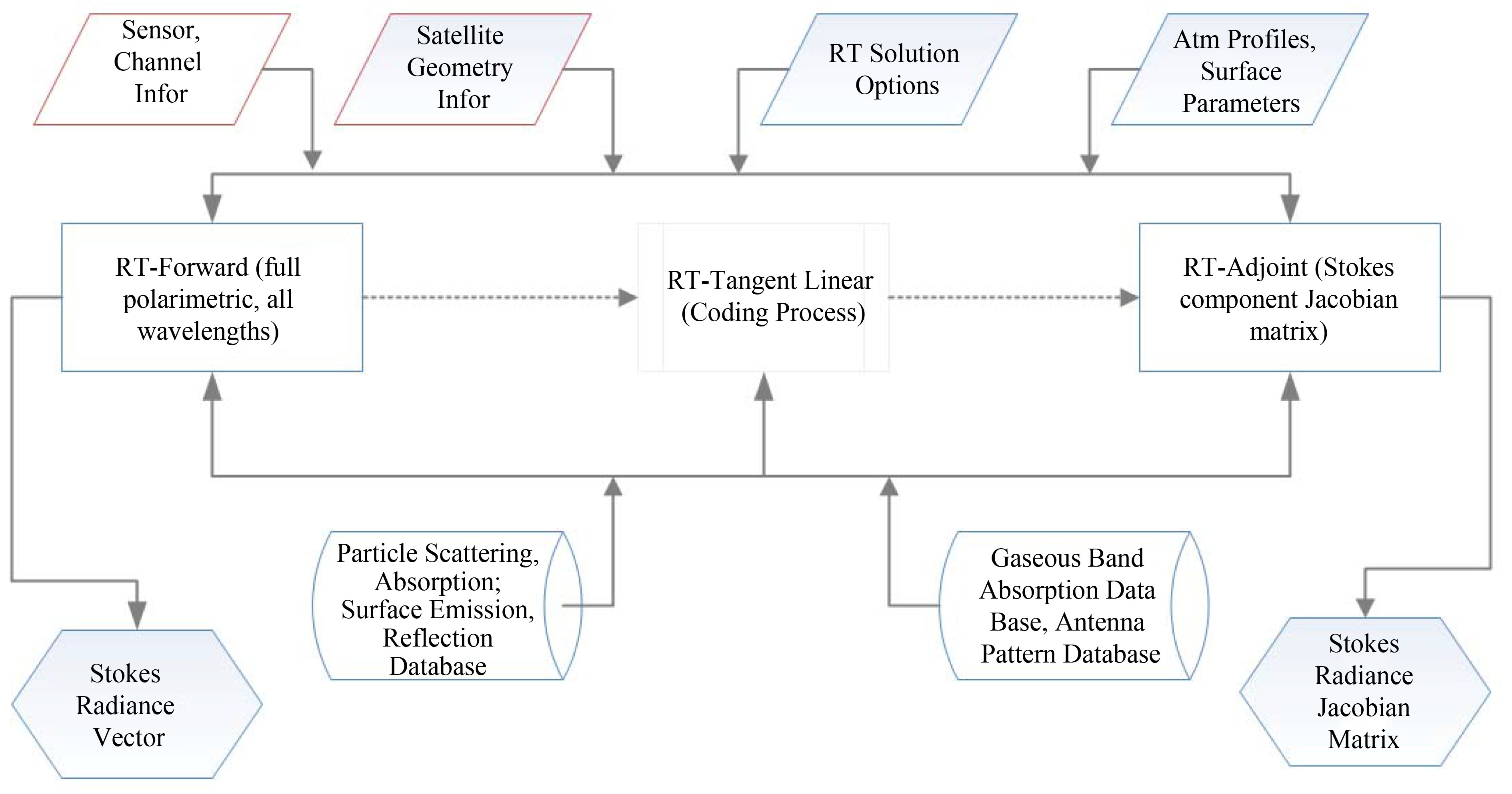 Figure1. ARMS, for fast and accurate calculations of satellite radiances and Jacobians at the top of atmospheres.
Radiative transfer simulation requires atmospheric optical parameters as inputs. Atmospheric optical thickness varies with atmospheric conditions and is often derived by using a spectroscopic database that has line-by-line (LBL) absorption coefficients. The LBL models are accurate but take a long time to calculate the atmospheric optical thickness profiles. In order to provide accurate optical parameters in the short time allotted in the operational forecast process, we have developed fast models that approximate the LBL calculations for each frequency at the specific satellite viewing angle. In LBLRTM, molecular line absorption parameters are selected from the HITRAN database (Rothman et al, 2013), and the self- and foreign-broadened water vapor continuum model of MT_CKD (Clough et al., 1992) as well as continuum absorption of carbon dioxide are also incorporated. The approach for a fast atmospheric transmittance calculation was developed by McMillin and Fleming (1976), and some incremental changes have been made by the community since then (Saunders et al., 1999; Han et al., 2007). In ARMS, the parameterized optical modules of each satellite instrument are also derived from the LBL calculation and convolved with the instrument spectral response function, resulting in an instrument-specific observation operator. For a hyperspectral IR instrument like CrIS or HIRAS, the accuracy is typically within 0.1 to 0.3 K within each spectral band.
In ARMS, the optical parameters of five hydrometeors associated with cloud and rain water, cloud ice, snow, and graupel are computed at each model layer. The atmosphere is divided into 100 layers and 101 levels. The liquid-phase hydrometeors are assumed to be spherical in shape and the scattering parameters are derived from Mie theory. The particle size distribution is a modified Gamma function in which the effective radii and a fixed effective variance are chosen. At each atmospheric layer, the total number of particles is derived from the layer water content for a given effective radius. For ice clouds, the scattering by particles similar to or larger than the wavelength of light is treated using a T-matrix (Bi and Yang, 2017) and is stored as a wavelength-consistent scattering database. The T-matrix is also used for computing the scattering parameters of aerosol particles.
The water-surface emissivity at microwave wavelengths is computed with a parameterized two-scale roughness model (Weng, 2017), which is called the Fast Emissivity Model, or FASTEM (Liu et al., 2011). In the two-scale model, the large-scale roughness is simulated from many small facets whose slopes follow the normal and isotropic distribution (Cox and Munk, 1954). The emission and reflection for each facet is approximated as a specular surface and the reflection at the viewing angle is calculated from the Fresnel formula. The effects of wave shadowing and surface reflection are taken into consideration. The small-scale capillary waves have a wavelength comparable to the radiation wavelength and their reflection is modeled through Bragg scattering. At the infrared wavelength, the water emissivity is simulated by the numerous small facets having a Cox?Munk slope distribution (Wu and Smith, 1997).
Land emissivity at the microwave frequency was developed earlier by Weng et al., (2001). It has a two-layer medium with the top layer having the scatters related to vegetation, or snow, and with the bottom soil layer. The soil reflectivities are first computed from the Fresnel formula and are then weighted with roughness and cross polarization factors. The radiation from volumetric scattering of vegetation or snow is derived from a two-stream radiative transfer model (Weng and Grody, 2000). The latest updates in surface roughness in the ARMS land emissivity model result in better simulations of microwave radiances at a wider frequency range (Chen and Weng, 2016). A polarization-dependent soil roughness model (Shi et al., 2005) is being implemented into the ARMS surface emissivity model.
Since the First Workshop on Remote Sensing and Modeling of Surface Properties held in Paris, France in 2006, the assimilation of satellite surface sensitive data in NWP models has been significantly improved. NWP centers have developed their respective strategies from the uses of land emissivity models and land surface products. In RTTOV, a Tool to Estimate Land Surface Emissivities at Microwave frequencies, or TELSEM (Aires et al., 2011) and the Combined ASTER and MODIS Emissivity over Land, or CAMEL (Borbas et al., 2017) at infrared wavelengths are used for simulations. In CRTM, the snow and sea-ice microwave emissivities are derived using satellite brightness temperatures at window channels and are stored as static databases at variable frequencies and viewing angles (Yan et al., 2008; Yan and Weng, 2011). These datasets are used to generate the emissivity spectra according to snow/sea-ice types. The spectrum range covers the frequency ranging from 5 to 200 GHz. These emissivity databases are also utilized in ARMS as an alternative solution to the land emissivity.
Currently, a polarized two-stream model (Liu and Weng, 2002) is implemented as a standard solver in ARMS. In addition, the advanced doubling-adding (or ADA) method (Weng and Liu, 2003; Liu and Weng, 2006), the vector double and adding (or VADA) scheme (Evans and Stephens, 1991), a vector discrete-ordinate radiative transfer model (or VDISORT) (Weng, 1992, 2017; Schulz et al., 1999) are also considered as alternative solvers in ARMS. These advanced solvers are designed for more accurate simulations in UV to visible wavelengths where scattering from molecules and aerosols can exhibit high anisotropic behaviors and require more streams in radiative transfer simulations. Users can also plug their own solvers into ARMS while taking full advantage of the system’s surface and atmospheric optical calculations.
| US | Europe | China | Japan |
| CrIS | IASI | HIRAS | AMSR-2 |
| ATMS | AMSU | GIIRS | |
| AMSU | MHS | MWTS | |
| MHS | AVHRR | MWHS | |
| HIRS | MWRI | ||
| MSU | MERSI | ||
| SSU | MERSI-II | ||
| AVHRR | |||
| MODIS | |||
| AMSR-E | |||
| AIRS | |||
| HSB | |||
| SSM/I | |||
| SSM/T1 | |||
| SSM/T2 | |||
| SSMIS | |||
| ABI | SEVERI | AGRI | AHI |
| GOES-Imager | GIIRS | ||
| GOES-Sounder | GOMIS |
Table1. Instrument-specific fast transmittance model developed for ARMS applications (instruments in italic are onboard polar-orbiting satellite systems and the rest are onboard geostationary satellite systems).
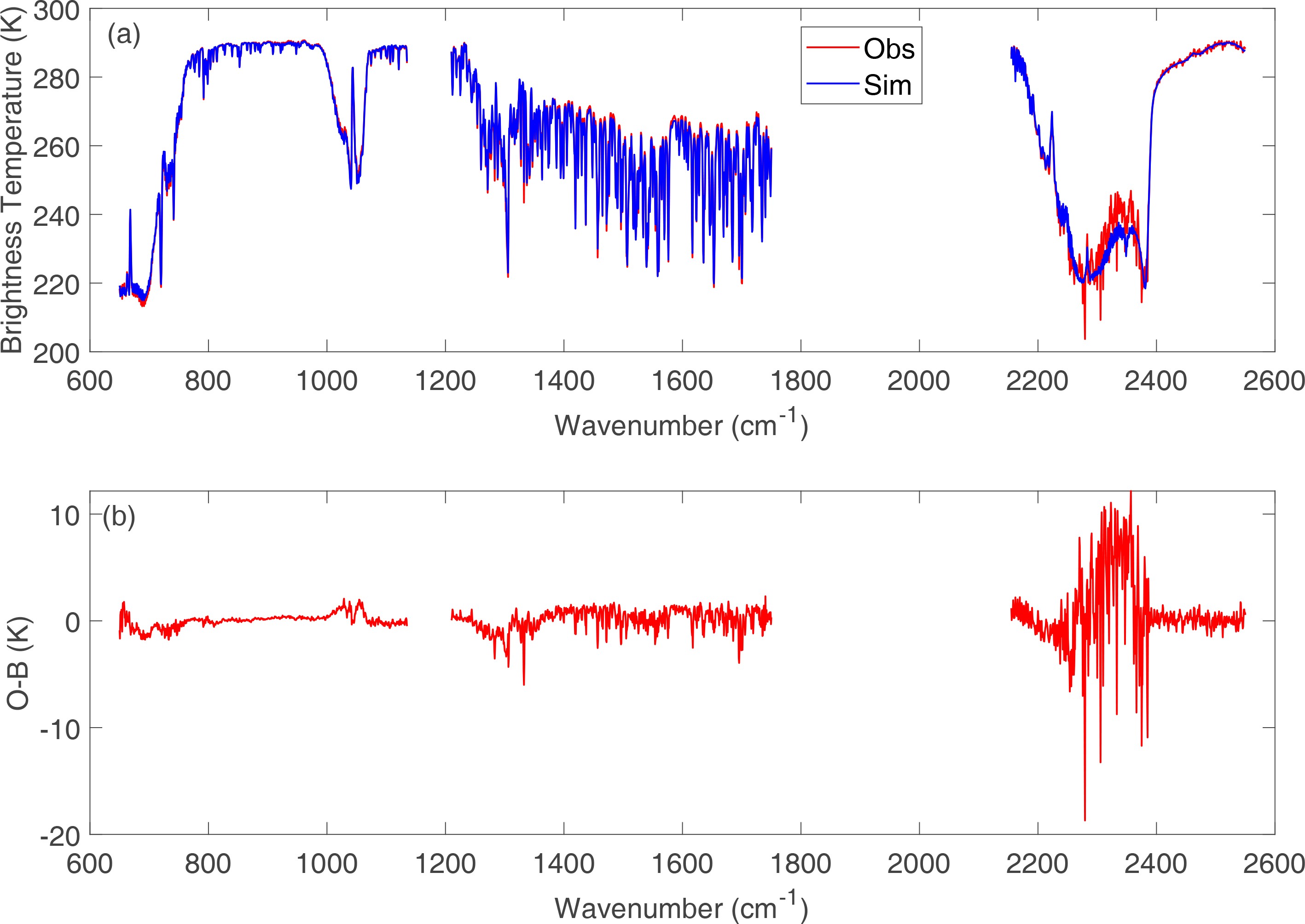 Figure2. (a) Simulated brightness temperature spectrum for the HIRAS instrument onboard the FY-3D satellite and comparison with (b) the difference between observations (O) and simulations (B)
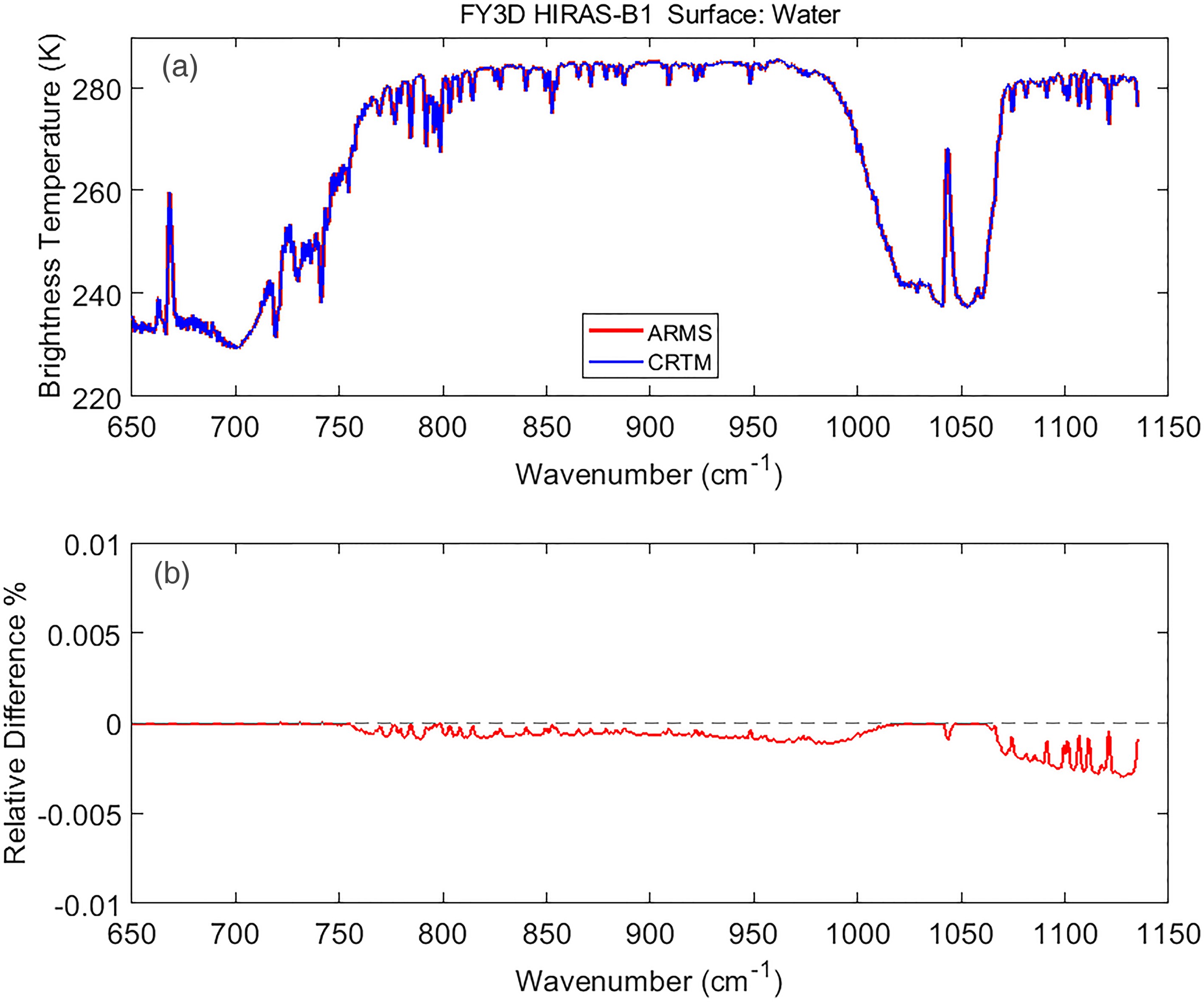 Figure3. (a) Simulation accuracy of HIRAS from ARMS and (b) difference between CRTM and ARMS.
The NOAA data assimilation system takes a three-dimensional variational (3D-Var) approach and has inherited the Gridpoint Statistical Interpolation (GSI) analysis system (Wu et al., 2002). GSI is a community data assimilation system with a comprehensive user guide and can be installed and compiled on various computer systems. CRTM is part of GSI and supports a large number of sensors onboard historical GOES/POES satellites. Unfortunately, CRTM does not support the new generation of FengYun satellites. Thus, we are now integrating ARMS into GSI so that all its users can perform assimilations of satellite data from global observing systems.
While ARMS is now ready for assimilating radiance data from satellite sounding instruments, it requires more scientific refinements to many modules. The near-term priority is to improve the simulation accuracy of satellite sounding instruments. In clear conditions, atmospheric optical models should consider trace gas components as NWP models start using more satellite measurements that are sensitive to them. For upper-air microwave sounding channels having weighting functions peaking above 40 km, Zeeman splitting absorption will be considered in ARMS (Han et al., 2007). At infrared wavelengths near 4 μm, absorbing aerosols can have significant effects on radiance simulation. Volcanic gases and aerosols can affect the radiance simulation at longwave infrared regions and should be fully considered in the transmittance calculation. At UV and visible wavelengths, the atmospheric gases also have scattering and create strong polarization. These features must also be accurately simulated in fast radiative transfer models. ARMS will include Rayleigh scattering of molecules and rotational Raman scattering when the UV hyperspectral data are ready for NWP data assimilation.
The gaps in our knowledge regarding surface emissivities must be filled. In ocean emissivity models, the water dielectric constant affected by salinity was updated earlier in FASTEM (Liu et al., 2011), but has been found to be incomplete at lower frequencies (Lawrence et al., 2017). Sea-ice emissivity is also limited. Over land, an infrared emissivity model has not yet been fully developed for operational fast and accurate radiative transfer models.
Acknowledgements. We would like to thank the support of the National Key Research and Development Program of China “Development of Meteorological Satellite Remote Sensing Technology and Platform for Global Monitoring, Assessments and Applications under the funding code of 2018YFC1506500”.
