 ,, 王姣, 马丽, 迪丽拜尔·吐尔孙新疆大学教育部绿洲生态重点实验室,乌鲁木齐 830046
OSL chronology reveals Late Pleistocene floods and the impact on landform evolution at the lower reaches of the Keriya River in the Taklamakan Desert
ZHANG Feng,, WANG Jiao, MA Li, TURSUN·DilibaierKey Laboratory of Oasis Ecology (Xinjiang University) Ministry of Education, Urumqi 830046, China收稿日期:2020-09-30修回日期:2021-06-30
| 基金资助: |
Received:2020-09-30Revised:2021-06-30
| Fund supported: |
作者简介 About authors
张峰(1973-), 男, 山东人, 博士, 副教授, 主要从事干旱区环境演变研究。E-mail:

摘要
关键词:
Abstract
Keywords:
PDF (4758KB)元数据多维度评价相关文章导出EndNote|Ris|Bibtex收藏本文
本文引用格式
张峰, 王姣, 马丽, 迪丽拜尔·吐尔孙. 克里雅河下游沉积物的光释光年龄与晚更新世末以来沙漠的形成. 地理学报, 2021, 76(9): 2240-2252 doi:10.11821/dlxb202109014
ZHANG Feng, WANG Jiao, MA Li, TURSUN·Dilibaier.
1 引言
塔克拉玛干沙漠是中国面积最大的沙漠[1,2,3,4,5,6,7]。关于其形成,舒莫夫认为是海成平原[2,6,8],那琳和西尼村等认为是古湖[2,6,8]。朱震达[9]深入研究了克里雅河下游的干三角洲,并以此提出这一带的沙漠是“就地起沙”形成于河流冲洪积平原之上,这一观点之后还得到来自沙漠内部的年代学数据[10,11,12]的支持。关于沙漠形成的时代,有****获得了沙漠下风向昆仑山北缘黄土的沉积年龄[4,5],并依据塔里木盆地现代环流格局[3]认为沙漠起源于中更新世[4]及第三纪的晚期[5]。沙漠中的沉积岩层还获得了晚新生代[13]和中新世的年龄[7]。但这都不意味着过去就存在一个如现在这般的沙漠,直接来自塔克拉玛干沙漠内部,牙通古斯河与安迪尔河下游地表亚粘土层下的沙质沉积物的光释光(Optical Stimulated Luminescence, OSL)年龄[14]显示,河流曾于约40 ka发生沉积并可能为沙漠提供了物源,现代沙漠景观形成的时代距今似乎并不那么遥远,塔里木盆地南缘其它河流下游的沙漠是否也与此相类似呢?克里雅河是一条发源于昆仑山并深入到塔克拉玛干沙漠腹地的河流[9, 15-17](图1),其流域范围北可至塔里木河,其下游河流与沙漠地貌发育[9-10, 16, 18-19],绿洲遗迹丰富[20],是认识沙漠内部的理想地带。中国科学院兰州沙漠研究所组织的沙漠考察[2, 21],第一次塔克拉玛干沙漠综合考察等[22],均将克里雅河下游列为了重点地区。相关成果为认识塔克拉玛干沙漠形成与演化问题提供了重要基础,其中曹琼英和夏训诚[10]、周兴佳[23]、李保生[11, 24]与靳鹤龄[25]等测定了沙漠沉积14C与热释光断代数据,获取了有关该地区沙漠演化的梗概。但早期的14C年龄对碳库效应[26]讨论较少,热释光年龄也或因晒退不彻底存在误差偏大的问题[27],这影响到对该河流及其流域沙漠演变问题的进一步认识。
图1
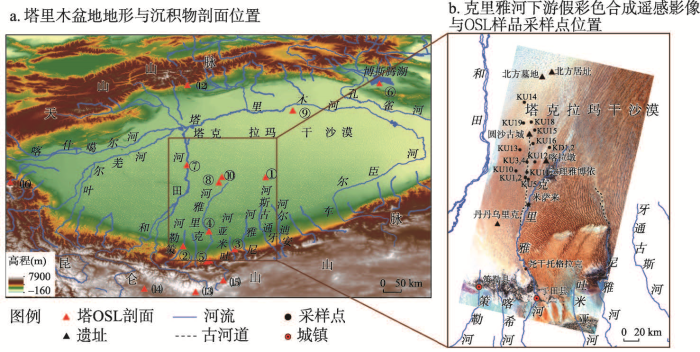 新窗口打开|下载原图ZIP|生成PPT
图1塔里木盆地地形与沉积物剖面位置及克里雅河下游Landsat8 OLI假彩色合成遥感影像(RGB: 7-5-2)与OSL样品采样点位置
注:① 牙通古斯和安迪尔河下游剖面[14]、② 策勒河上游沙楔[14]、③ 吐米亚河下游剖面[14]、④ 尧干托格拉克剖面[10, 14]、⑤ 普鲁羊场阶地[52]、⑥ 博斯腾湖剖面[53]、⑦ 和田河麻扎塔格古河道断面[25]、⑧ 克里雅沙漠腹地剖面[25]、⑨ 塔河中游剖面[50,51]、⑩克里雅剖面[11]、? 阿羌剖面[40]、? 木扎尔特破城子冰碛[43]、? 崇测冰川冰碛[48]、? 甜水海湖泊沉积[41]、? 克里雅冰川冰碛[47]、? 公格尔山冰碛[45,46,47,48,49]
Fig. 1Map showing the elevation of the Tarim Basin (ASTER GDEM). Red solid triangles represent the location of published age sampling sites and processed Landsat8 (Operational Land Imager, OLI) false color image (RGB: 7-5-2) showing the Keriya River lower reaches and sampling sites in this work
光释光技术对于测定年轻地质体的埋藏年代十分理想[28],由于沙漠环境下风沙[29]及河流沉积曝光均良好[30],其成为近来沙漠演化研究的重要手段[31]。然而目前研究区已有的光释光年代学数据较少,且时间主要集中在全新世后期[14, 19]。本文新报道了克里雅河下游沙漠深处更广范围沉积物的光释光年龄,以期为认识克里雅河下游及塔克拉玛干沙漠地貌的形成与演化提供新数据。
2 克里雅河下游概况
克里雅河下游为暖温带沙漠气候[23]。以达理雅博依为例,年均降水不足10 mm/a[23],年均气温约11.8 ℃(2015年)[32]。河流主要受昆仑山山区冰雪融水补给[23],年径流量约 9×10⁸ m3,春、夏各有2个洪水期和枯水期(据新疆和田水文局),在下游沙漠形成时令河[23]。河流年输沙量3.51×10⁶ t[9]。植物主要见胡杨(Populus euphratica)、灰杨(Populus schrenk)、柽柳(Tamarix spp.)、芦苇(Phragmites australis)等[17]。克里雅河下游大致可分为2段,上段自于田县至米萨来一带,下段为米萨来以北(图1b)。上段河道较为固定,在尧干托格拉克、于田克里雅大桥与米萨来等地留有自老至新的阶地[10, 14, 23-24, 33]。尾闾的达理雅博依荒漠河岸林绿洲形成于约0.4 ka[33,34]。在达理雅博依乡政府以西20 km有一处干三角洲,存有形成于约汉至唐代的喀拉墩古城[20]。遥感影像中,在米萨来以西(图1b)可见另处干三角洲及古河道通向春秋战国至魏晋的圆沙古城[19-20, 35]。圆沙古城以北约80 km的沙漠更深处,存有2处更老的青铜器时代遗址[36]。唐代丹丹乌里克遗址[9]及所在的干三角洲则位于河流下游上段。在这些干三角洲上,古河网、新月形沙丘与新月形沙丘链密布,外围则多分布较大规模沙垄(图1b)。
3 材料与方法
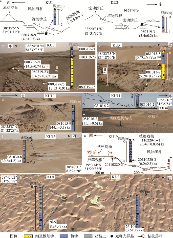
本文采样点大致覆盖了克里雅河下游的西部,特别是在现代和田河与克里雅河之间沙漠深处也有分布,但暂未涉及克里雅河下游以东地区。在16个剖面获得共18件OSL年代学样品(图1、图2),剖面多具亚粘土和粉沙互层的二元沉积旋迴结构(图2)。其中剖面KU1、KU2、KU3与KU16位于通往圆沙古城的古河道一带,KU1为风蚀阶地,KU2为风蚀河谷,2处剖面相距约2.5 km。KU3为风蚀露头。KU5、KU11与KU12位置在现代克里雅河与通往圆沙古城的古河道间,其中KU5为人工开挖露头,其上部为风成沙,其下沉积物(081013-7)见波状层理,底部为具有斜层理的风成沙(081013-7)。KU16、KU11与KU12皆位于风蚀河谷谷坡。剖面KU18与KU19为圆沙古城东部风蚀河漫滩残存,剖面均见亚粘土及下部粉沙,胡(灰)杨等植物残存。KD1与KD2剖面位于喀拉墩一带,KD1为风蚀河床,KD2为河床西侧一柽柳沙堆。KU10与KU13剖面为古河床的风蚀露头,位置接近和田河(图1b)。图2
 新窗口打开|下载原图ZIP|生成PPT
图2克里雅河下游沉积物剖面与OSL年龄样品
Fig. 2Sampled section: lithology and sediment OSL samples
光释光年龄样品均取自亚粘土层之下新开挖的沙质沉积物,样品埋藏深度与剖面剥离深度均大于50 cm。使用不锈钢罐避光条件下采集,铝箔迅速密封。实验室编号首序号12009样品5件OSL年龄由中国科学院寒区旱区环境工程研究所给出,2009年测。由内嵌90Sr/Y放射源Riso-TL/OSL-DA-15光释光年代分析仪测定(丹麦)等效剂量,其中除080319-25测定矿物为长石外其它皆为石英,含水率最高为3.1%,误差按50%计。首序号10G(2010年测)与11G(2011年测)样品13件年龄由中国地质科学院水文地质环境地质研究所光释光实验室给出,用Daybreak 2200(美国)光释光仪、801E辐照仪(β放射源90Sr-Y),剂量率约(0.103871Gy/Secβ)。所测矿物为石英,其中样品11G-228与11G-234选用粗颗粒(90~125 μm)单片再生法测量,预热温度260 ℃,循环比小于5%。其余选细颗粒(8~15 μm)简单多片再生法测得等效剂量,饱和指数法拟合。U、Th和K含量中子活化法测得,宇宙射线贡献据Prescott和Hutton推荐数据估计[37]。首序10G样品含水率按10%,11G按(5±1)%估算,Fleming法修正[38]。各实验室U、Th和K含量测定结果较一致(表1),年龄误差基本在10%内,且所测本区域沉积物光释光年龄与同层位植物14C年龄吻合较好[19],基本可信。KU3剖面底部样品080319-25虽然较之上另外2个样品年轻(图2),但在误差范围内3件样品年龄基本一致,且该样品所测矿物为长石,显示光释光方法在沙漠样品年龄测定方面的可靠。
Tab. 1
表1
表1克里雅河下游沉积物样品光释光年龄
Tab. 1
| 剖面 | 实验室号 | 野外编号 | U(ppm) | Th(ppm) | K(%) | 等效剂量(Gy) | 年剂量(Gy/ka) | 年龄(ka) |
|---|---|---|---|---|---|---|---|---|
| KU1 | 10G-268 | 080318-9 | 2.48±0.09 | 9.64±0.28 | 1.78±0.06 | 16.69±0.80 | 3.63±0.15 | 4.6±0.30 |
| KU2 | 10G-269 | 080319-3 | 2.50±0.09 | 11.1±0.31 | 1.61±0.06 | 12.37±0.56 | 3.62±0.15 | 3.4±0.20 |
| KU4 | 10G-270 | 080321-1 | 1.69±0.07 | 7.50±0.23 | 1.73±0.06 | 23.10±1.09 | 3.13±0.13 | 7.4±0.40 |
| KU11 | 10G-271 | 081016-2 | 3.16±0.11 | 14.2±0.38 | 1.70±0.06 | 47.03±1.46 | 4.23±0.17 | 11.1±0.60 |
| KU12 | 10G-272 | 081022-3 | 2.10±0.08 | 8.00±0.24 | 1.87±0.06 | 30.00±0.57 | 3.44±0.10 | 8.7±0.40 |
| KU13 | 10G-273 | 081030-8 | 2.27±0.09 | 6.91±0.23 | 1.76±0.06 | 138.59±3.03 | 3.30±0.13 | 39.6±1.80 |
| KU14 | 10G-275 | 081104-1 | 1.96±0.08 | 7.75±0.23 | 1.68±0.06 | 20.09±0.22 | 3.20±0.16 | 6.3±0.30 |
| KU15 | 10G-276 | 081106-2 | 1.87±0.07 | 7.12±0.21 | 1.82±0.06 | 24.34±0.24 | 3.25±0.10 | 7.5±0.30 |
| KU10 | 10G-277 | 081015-9 | 1.91±0.07 | 9.55±0.28 | 1.81±0.06 | 153.42±8.79 | 3.48±0.17 | 44.1±3.10 |
| KU18 | 11G-228 | 20110215-4 | 2.27 | 7.77 | 1.67 | 16.73±0.66 | 2.99 | 5.6±0.30 |
| KU19 | 11G-229 | 20110220-3 | 2.07 | 8.52 | 1.69 | 20.38±0.48 | 3.37 | 6.0±0.30 |
| KD1 | 11G-234 | 26-9 | 1.87 | 7.86 | 1.54 | 24.32±1.55 | 2.76 | 8.8±0.70 |
| KD2 | 11G-235 | 26-10 | 1.99 | 6.68 | 1.69 | 11.64±0.33 | 3.21 | 3.6±0.20 |
| KU3 | 12009-28 | 080319-21 | 2.59±0.10 | 6.59±0.20 | 1.78±0.05 | 42.44±1.83 | 2.93±0.08 | 14.50±0.74 |
| KU3 | 12009-29 | 080319-23 | 2.30±0.09 | 8.06±0.23 | 1.58±0.05 | 40.44±1.11 | 2.77±0.09 | 14.59±0.67 |
| KU3 | 12009-30 | 080319-25 | 2.40±0.09 | 8.06±0.23 | 1.73±0.05 | 44.26±2.89 | 3.27±0.12 | 13.53±0.90 |
| KU5 | 12009-32 | 081013-7 | 2.5±0.09 | 9.26±0.26 | 1.8±0.05 | 16.52±0.63 | 3.13±0.09 | 5.28±0.25 |
| KU16 | 12009-37 | 081107-1 | 2.52±0.09 | 8.63±0.25 | 1.72±0.05 | 11.18±1.83 | 3.00±0.08 | 3.72±0.62 |
新窗口打开|下载CSV
4 结果
全新世OSL年龄样品数据量最多(图1b与表1)。自米萨来通往圆沙古城古河道一带,KU2剖面样品080319-3年龄为(3.4±0.2) ka,阶地KU1剖面样品080318-9年龄为(4.6±0.3) ka,阶地KU16样品081107-1在(3.72±0.62) ka;圆沙古城一带干三角洲东部剖面KU18和KU19样品20110215-4与20110220-3年龄分别在(5.6±0.3) ka与(6.0±0.3) ka(图2)。圆沙干三角洲最北剖面KU14样品081104-1与通往圆沙古城的古河道西测剖面KU4的样品080321-1年龄分别为(6.3±0.3) ka和(7.4±0.4) ka。喀拉墩遗址以北古河床剖面KD1沉积物样品26-9年龄为(8.8±0.7) ka,柽柳沙堆剖面KD2样品26-10为(3.6±0.2) ka,均分布在全新世。圆沙古城与喀拉墩古城间的剖面KU5,KU12与KU15的沉积物081013-7,081022-3与081106-2年龄分别为(5.28±0.25) ka、(8.7±0.4) ka和(7.5±0.3) ka。通往圆沙古城古河道西侧剖面KU3的3件样品080319-21、080319-23与080319-25年龄相近,分别为(14.5±0.74) ka、(14.59±0.67) ka和(13.53±0.90) ka,对应于末次盛冰期(Last Glacial Maximum, LGM)的末期。2处距离和田河较近剖面KU10及KU13样品081015-9与081030-8,分别为(44.1±3.1) ka和(39.6±1.8) ka,对应于深海氧同位素3阶段(Marine Isotope Stages 3, MIS3)。5 讨论
5.1 河流的活动
河流沉积样品年龄代表了河流活动的时间。圆沙古城与喀拉墩古城周围三角洲及它们之间河流沉积物的OSL年龄分布于3—11 ka,反映了全新世河流的活动。KU2风蚀古河岸岸坡的样品080319-3年龄(3.4±0.2) ka显示当时河流的经过,而其阶地KU1应为约4.6±0.2 ka河流沉积而成(图2),约3.7 ka古河流或经圆沙古城西侧KU16剖面(样品081007-2年龄(3.72±0.62) ka)所在位置通往了北方墓地一带。剖面KU11与KU12则代表克里雅河在(11.1±0.6) ka与(8.7±0.4) ka的流经。KU5剖面底部风沙081013-7年龄(5.28±0.25) ka与上部河流沉积081013-5年龄(2.78±0.4) ka[19]反映该地区早期的风沙活动与后期河流的到达。KU4、KU14、KU15与KU16均显示全新世河流活动的范围之广。KU18与KU19(图2)沉积物年龄基本一致,反映克里雅河6.0 ka前后经过圆沙以东,14C数据[35]则显示之后2.3 ka河流曾再次流至并有植被发育。喀拉墩一带KD1与KD2(图2)显示约8.8 ka克里雅河流经,之后约3.6 ka到达。OSL年龄的空间分布(图1b)还表明克里雅河全新世期间在圆沙和喀拉墩之间的迁移,KU5、KU11与KU12应分别为河流在(2.78±0.4) ka[19]、(11.1±0.6) ka和(8.7±0.4 ka) 的迁移中留下的记录(图1b、图2)。地势控制着水流方向,和田河与克里雅河下游地势总体向北倾斜,与现代和田河与克里雅河流动方向一致。但研究区位于两河之间洪泛平原,总体较为平坦,特别是在东西方向上(图1)高差并不是很大,河流容易在这里发生改道。但由于沙漠内部河流易遭受下渗和蒸发,策勒河等塔里木盆地南缘的小河在现有径流条件下很难到达到KU10与KU13样品所在位置,而根据遥感影像中OSL样品的空间分布(图1b),克里雅河全新世主要活动于圆沙与喀拉墩一带,据麻扎塔格古河床断面[12],约2万年以来和田河也主要活动于现代河流附近,因此仅大规模洪水时克里雅河或和田河才有可能发生大幅摆动而流动到KU10与KU13剖面位置。同时洪水期地下水水位还会抬升,从而为塔里木盆地南缘小河深入至沙漠提供了条件。剖面KU10与KU13处的河流沉积光释光年龄与牙通古斯河和安迪尔河下游河湖相沉积物[14]较一致,显示MIS3阶段末塔里木盆地南缘可能普遍发生洪泛。
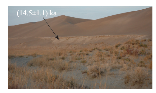
剖面KU3自顶部至底部深度达5 m(图2),顶部1 m沉积物具有上部亚粘土和下部粉沙的二元结构,3件OSL样品的年龄均在14.5 ka前后,该剖面OSL年龄与克里雅河下游上段尧干托格拉克洪水堆积阶地一致[10, 14](图3),显示了克里雅河下游LGM末洪水对下游的影响范围。
图3
 新窗口打开|下载原图ZIP|生成PPT
图3克里雅河下游尧干托格拉克的阶地
注:2008年张峰拍摄;图中数据来自文献[14]。
Fig. 3The sketch showing the terrace at Yohan Tohrak
5.2 气候背景
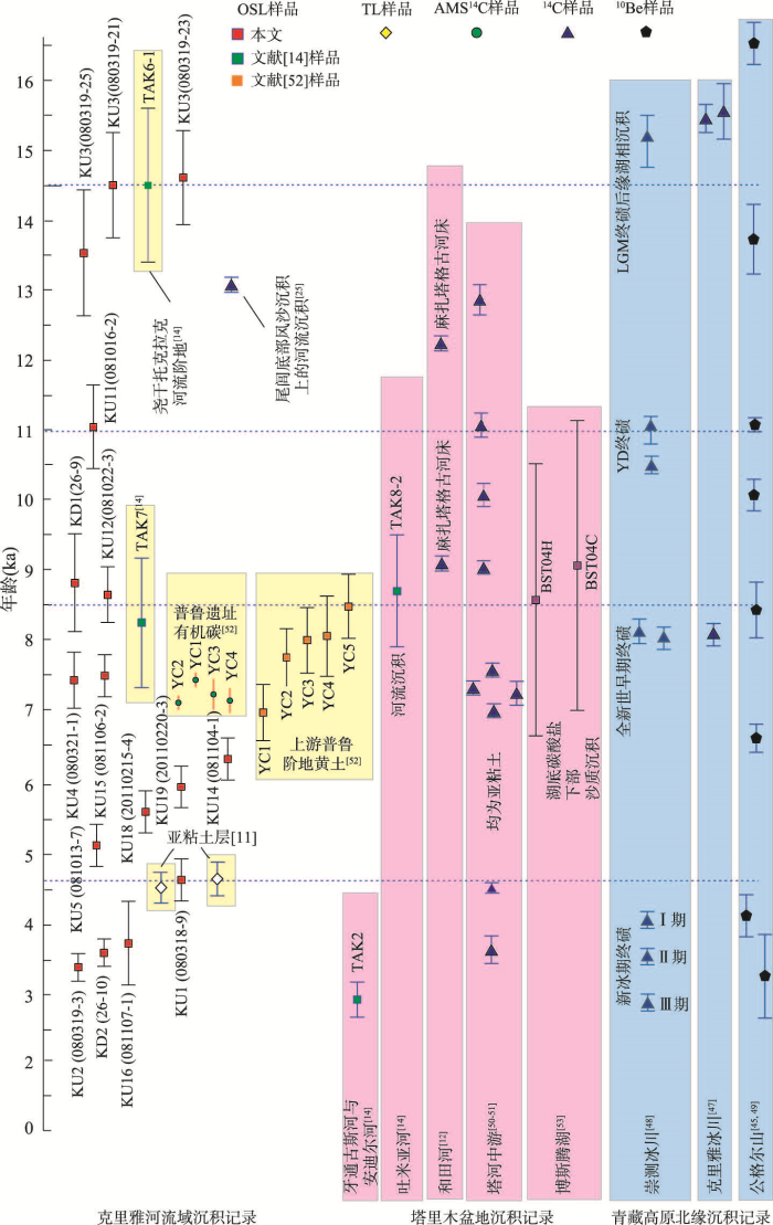
5.2.1 MIS3阶段 塔里木盆地河流洪水的产生有多种原因,如山区溃坝性洪水等突发性事件和降水变率的变化等[39],但总体上受控于气候冷暖干湿变化,如气温增高与太阳辐射增强引起的冰川融化,降水的增加和气候的变湿[14]等。KU10与KU13剖面样品年龄形成于约38—47 ka,据此期间昆仑山北坡黄土记录[40],塔克拉玛干沙漠未发现显著变湿,沙漠腹地KU10与KU13河湖沉积应不是平原区降水增加的结果。与之相应,38—47 ka 前后青藏高原冰川可能消融,克里雅河上游甜水海就获得了(41.706±4.749) ka前后高湖面的铀系测年数据[41,42]。青藏高原北麓冰消引发的河流径流增加或导致了本文KU10与KU13剖面及牙通古斯河与安迪尔河下游河湖沉积[14]在沙漠的形成。亦有天山南麓海拔高约1900 m木扎尔特河出山口测得冰碛物39.5(±10%) ka和40.4(±10%) ka的电子自旋共振(ESR)年龄[43],中亚兴都库什山冰碛物测得(36.6±3.0)—(40.9±3.5) ka的OSL年龄[44],昆仑山西部公格尔山冰碛测得(36.4±3.3)—(48.7±5.7) ka的ESR年龄[45],塔里木盆地南缘策勒河上游阶地沙楔测得(40.6±0.32) ka的OSL年龄[14](图1a、图4)等报道,这均暗示冰川的前进。以上冰川消融与冰进年龄数据的接近,但这并不相悖,MIS3阶段气候波动剧烈,冰消可能紧随冰进而发生。图4
 新窗口打开|下载原图ZIP|生成PPT
图4克里雅河流域沉积物OSL年龄与塔里木盆地河流及周边山脉沉积物测年数据
Fig. 4Plot showing sediment ages along the Keriya River and around the Tarim Basin
5.2.2 LGM末 LGM以来塔克拉玛干沙漠干湿变化似乎并不显著[11]。青藏高原曾可能发育亚极地型冰川[46],克里雅冰川前缘测得了(15.55±0.15) ka和(15.79±0.384) ka的冰碛物14C年龄[47],昆仑山山前策勒河阶地上发现有OSL年龄(18.3±1.3) ka的沙楔[14],破城子第3列终碛垄冰碛物测得13.6 ka(±10%)的ESR年龄[43](图1a、图4)。但LGM之后气温是波动上升的,冰川的融化可能再次在克里雅河发生洪泛,并约14 ka 前后在尧干托格拉克[10, 14]一带形成河湖沉积并深入到本文KU3剖面一带。青藏高原北缘也应发生相应的冰消和高湖面,崇测冰川LGM终碛垄前缘湖相沉积就测得了(14.93±0.37) ka的14C年龄[48]。
5.2.3 全新世 MIS3阶段末与LGM末河洪沉积与冰进之后的冰消有较好的对应,全新世气候冷暖波动显著,也应发生相类似的过程。全新世早期,克里雅上游崇测冰川或在新仙女木期14C年龄(11.087±0.198) ka形成YD终碛垄[48],公格尔山也测得(11.2±0.1) ka与(10.2±0.3) ka 的冰碛物10Be年龄[49](图1a、图4);KU11剖面显示克里雅河于(11.1±0.6) ka在圆沙一带的活动,塔河中游也测得14C年龄(11.19±0.177) ka与(10.6±0.165) ka的湖相亚粘土沉积[50,51]。8.5 ka前后克里雅河一带冰川可能亦发生进退,克里雅冰川和崇测冰川8.5 ka前后形成终碛垄,公格尔山测得(8.4±0.4) ka的10Be 的冰碛物年龄,冰进似乎发生;在克里雅河中游普鲁羊场,一套黄土披覆于河流阶地,黄土底部OSL年龄(8.46±0.46) ka[52],其下部河流沉积或许记录了8.5 ka冰进后冰川消融产生的洪水,这与克里雅河下游喀拉墩和圆沙一带OSL年龄(8.8±0.7) ka和(8.7±0.4) ka的KD1与KU12剖面记录的河流活动,博斯腾湖底部OSL年龄(8.53±0.194) ka和(9.14±2.07) ka风成沙[53]之上湖相沉积开始堆积的时间较一致。4.2—3.8 ka前后北半球气候波动[54],崇测冰川和克里雅河上游冰川均形成终碛垄[47],公格尔山也测得(4.2±0.3) ka前后10Be年龄[49],青藏高原也被认为(3.8±0.6) ka发生冰进[55]。冰进后期往往发生冰消,KU16、KD2与KU2揭示克里雅河曾于(3.72±0.62) ka、(3.6±0.2) ka与(3.4±0.2) ka在沙漠中的发育或暗示了冰进后的消融。
全新世河流下游河洪事件光释光年龄与塔里木盆地周缘冰进冰消并不完全对应。如中游羊场遗址剖面夹层有机质AMS14C测年显示黄土在6.942—7.564 ka前后[52]发生堆积,之后未被河流冲蚀(也存在因构造抬升引起河流下切,后期洪水难再影响黄土堆积的可能),环境似乎开始变干,但本文克里雅河下游OSL年龄显示(7.4±0.4) ka、(7.5±0.3) ka、(6.3±0.3) ka、(6.0±0.3) ka、(5.6±0.3) ka与(5.28±0.25) ka依然有河流活动。此外,KU1阶地OSL年龄(4.6±0.3) ka与前人所测克里雅河下游另两处亚粘土沉积热释光年龄(4.48±0.22) ka与(4.74±0.24) ka[11],及塔河中游一带测得(4.497±0.097) ka亚粘土沉积物的14C年龄[50,51]均暗示4.5 ka前后的洪水泛滥,但塔里木盆地周缘似乎没有较显著的冰川进退记录与之相对应,其原因可能是由于年代学数据的缺少或早期热释光和14C年龄数据误差较大。
5.3 沙丘的形成
三角洲上沙丘发育的影响因素有很多,主要与风有关,但也还受其它如地形地貌[56]与河流等因素的影响[57]。克里雅河下游区域大气环流基本一致[58],地势总体平坦[9, 11-12, 23],河流很大程度上参与了沙丘的形成[12]并可能影响到其建造。在克里雅河下游多见亚粘土和粉沙互层河流沉积的风蚀残存(图5),可见河流沉积为沙丘形成提供了物源[1, 9]。圆沙三角洲一带粒度测定结果亦显示,河流沉积主要为粘土质粉沙,粉沙与极细沙组成,而沙丘沙粒度则总体稍粗,主要由粉沙和极细沙组成[59],显示了沙丘沙由河流沉积经风的分选和改造而成的过程。与牙通古斯河与安迪尔河下游[14]的情况一致,本文克里雅河下游最早河洪沉积记录的OSL年龄在MIS3阶段,自那时起,河流可能就已开始为沙丘发育提供物源了。图5
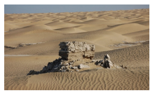 新窗口打开|下载原图ZIP|生成PPT
图5圆沙古城沙丘与河流沉积风蚀残留
注:2008年张峰摄于(38°47′N; 81°35′E);沙质沉积上部具水平层理亚粘土。
Fig. 5A wind-eroded river bed residual near the Yuansha Site
朱震达先生曾根据喀拉墩和丹丹乌里克遗址的年代认为克里雅尾闾干三角洲与河流以西的沙丘形成于“汉唐以来”[9],但当时该区域更早时代的遗址尚未被报道,加之早期年代学数据极少,这一观点或需被重新认识。北方墓地、圆沙古城和喀拉墩遗址的存在说明克里雅河干三角洲曾经发育荒漠河岸林,流动沙丘主要是在河流改道和遗址废弃之后形成的,由于干三角洲为河流堆积形成,其形成主要在全新世,因此沙丘也应在这一时段以来形成。
另一方面,河流活动也可能影响到沙丘规模。圆沙和喀拉墩一带干三角洲上的新月型沙丘和沙丘链的相对低矮,或许是受河流摆动冲涤影响难以长期堆积的结果。在圆沙和喀拉墩之间的区域(KU5、KU11和KU12),及克里雅河与和田河之间的区域发育一定规模的纵向沙垄,可能与受河流作用较少而受风力作用较久有关。部分发育较为高大的沙丘,其下伏沉积年龄也的确较老,如克里雅河东岸尧干托格拉克一带LGM末河流阶地上的沙丘。
塔克拉玛干沙漠中的河流对地貌发育有着较为深刻的影响,而确如此前的讨论,即沙漠腹地克里雅河的河洪沉积与上游冰川进退相关,可认为现代塔克拉玛干沙漠地貌格局的形成是受控于气候变化的。
6 结语
通过发源于塔里木盆地周缘高山的河流在沙区的沉积物年龄,可认识塔克拉玛干沙漠腹地地貌形成与演化相关问题,但理想的数据较少。考察了沙漠深处塔里木盆地南缘克里雅河下游,采集了沉积物光释光样品。所测年龄结果集中分布在MIS3阶段的38—47 ka,LGM末14.5 ka与全新世11 ka、8—9 ka、5—6.5 ka、4.6 ka与3.4—3.7 ka前后。出露于地表河流沉积物年龄差距达数万年。全新世样品多分布于圆沙与喀拉墩干三角洲及其之间的地区,MIS3阶段样品接近和田河,LGM样品则离克里雅河稍远。河流沉积物反映了河洪泛滥,河流活动影响到地貌发育。克里雅河下游干三角洲的沙丘应形成于全新世以来。河流沉积年龄与塔里木盆地周缘山脉的冰进与冰退有一定对应。由于早期发布的沙漠内部河湖沉积14C年龄较少考虑碳库效应,冰碛物年龄测定数据也存在不一致现象,若将全新世塔克拉玛干沙漠洪水活动与冰川进退确定的联系起来,还存在诸多困难。但由于沙漠环境中沙粒具有曝光良好的特点,OSL方法提供了较其它手段更为可靠的年龄。特别是沙漠深处各河洪沉积物出现的时间,均对应着特殊的气候转折,是偶然还是必然,其背后的机制还有待进一步深入。致谢
感谢浙江大学杨小平教授和中国科学院新疆生物与地理所周兴佳研究员对本文的修改建议;中国科学院西北生态环境资源研究院赵晖研究员、中国地质科学院水文地质环境地质研究所赵华研究员和王承敏工程师承担了光释光年龄样品的测定和分析,特表感谢!参考文献 原文顺序
文献年度倒序
文中引用次数倒序
被引期刊影响因子
[本文引用: 2]
[本文引用: 2]
[本文引用: 4]
[本文引用: 4]
[本文引用: 2]
[本文引用: 2]
[本文引用: 3]
[本文引用: 3]
DOI:10.1126/science.1124616URL [本文引用: 3]
DOI:10.1016/j.quascirev.2011.08.009URL [本文引用: 3]
DOI:10.1073/pnas.1424487112PMID:26056281 [本文引用: 2]

As the world's second largest sand sea and one of the most important dust sources to the global aerosol system, the formation of the Taklimakan Desert marks a major environmental event in central Asia during the Cenozoic. Determining when and how the desert formed holds the key to better understanding the tectonic-climatic linkage in this critical region. However, the age of the Taklimakan remains controversial, with the dominant view being from ~ 3.4 Ma to ~ 7 Ma based on magnetostratigraphy of sedimentary sequences within and along the margins of the desert. In this study, we applied radioisotopic methods to precisely date a volcanic tuff preserved in the stratigraphy. We constrained the initial desertification to be late Oligocene to early Miocene, between ~ 26.7 Ma and 22.6 Ma. We suggest that the Taklimakan Desert was formed as a response to a combination of widespread regional aridification and increased erosion in the surrounding mountain fronts, both of which are closely linked to the tectonic uplift of the Tibetan-Pamir Plateau and Tian Shan, which had reached a climatically sensitive threshold at this time.
[本文引用: 2]
[本文引用: 2]
[本文引用: 8]
[本文引用: 8]
[本文引用: 7]
[本文引用: 7]
[本文引用: 6]
[本文引用: 6]
[本文引用: 4]
[本文引用: 4]
[本文引用: 1]
DOI:10.1016/j.quascirev.2005.06.008URL [本文引用: 16]
[本文引用: 1]
[本文引用: 1]
[本文引用: 1]
[本文引用: 2]
[本文引用: 2]
[本文引用: 1]
[本文引用: 1]
[本文引用: 6]
[本文引用: 6]
[本文引用: 3]
[本文引用: 3]
[本文引用: 1]
[本文引用: 1]
[本文引用: 1]
[本文引用: 1]
[本文引用: 7]
[本文引用: 7]
[本文引用: 2]
[本文引用: 2]
[本文引用: 3]
[本文引用: 3]
PMID:16589473 [本文引用: 1]
[本文引用: 1]
[本文引用: 1]
DOI:10.11820/dlkxjz.2013.05.001 [本文引用: 1]
Since its development in the 1980s, optically stimulated luminescence(OSL) dating has been improved significantly. Even though the error is larger(normally 5%~10%), it has obvious advantageous over radiocarbon dating: larger dating range from decadal up to ~700 ka, abundant dating materials(quartz or feldspars), dating directly the sediment, etc. The purpose of the paper is to introduce the method to those geoscientists who intend to use OSL dating for chronological control so that the sampling in the field will satisfy OSL chronologists. We describe the procedures of OSL dating in the luminescence dating laboratory of Qinghai Institute of Salt Lakes, CAS, including sampling, pretreatment, equivalent dose (<i>De</i>) and dose rate determination. We make some suggestions for OSL sampling from strata or drilling cores. In our laboratory we combine the single aliquot regenerative-dose(SAR) and standardised growth curve(SGC) techniques together for De determination, which we call SAR-SGC method with the advantage of reducing machine occupation time for at least 60% compared to that of the SAR method. The abstract of pure quartz of middle grains (38~63 μm) using fluorocilicic acid (H<sub>2</sub>SiF<sub>6</sub>) could be much easier and simpler compared to that of coarse grains(90~120 μm) and fine grains(4~ 11 μm), without the use of dangerous hydrofluoric acid(HF). Our systematic investigations on the use of SAR-SGC method for different sediments(aeolian, lacustrine, marine, and glacial, etc.) have shown that the method is valid, even though some factors may result in complexity, e.g. the contamination of heavy minerals and feldspars, the thermal history of quartz grains, etc. Since 2008, we have been applying, with success, the SAR-SGC method to dating loess, desert, lacustrine, ocean, glacial, earthquake, and archaeological site sediments, etc.
[本文引用: 1]
DOI:10.1016/j.geomorph.2003.07.021URL [本文引用: 1]
[本文引用: 1]
[本文引用: 1]
[本文引用: 1]
[本文引用: 1]
[本文引用: 1]
[本文引用: 1]
[本文引用: 2]
[本文引用: 2]
[本文引用: 1]
[本文引用: 1]
[本文引用: 2]
[本文引用: 2]
[本文引用: 1]
[本文引用: 1]
DOI:10.1016/1350-4487(94)90086-8URL [本文引用: 1]
DOI:10.1016/S1350-4487(97)00204-7URL [本文引用: 1]
[本文引用: 1]
[本文引用: 1]
[本文引用: 2]
[本文引用: 2]
[本文引用: 2]
[本文引用: 2]
DOI:10.11821/xb200002005 [本文引用: 1]
The paleo lake shorelines and lake deposits are widely distributed in the lake basins on the Xizang (Tibetan) Plateau. Deduced from the highest lake shorelines, the lakes area during the last Greatest Lake Period (GLP) was several to tens times larger than their present area. However, there are still divarication on its age, e.g. some thought GLP was formed in the early and middle Holocene, some thought GLP in the Last Glacial Interval, also some thought in the early middle period of Pleistocene. There is no final conclusion related to the last GLP on the total plateau. According to the analyses of the lake deposits and 14 C dating from 12 lakes such as Tianshuihai Lake, etc., the GLP on the Xizang Plateau was formed generally from 50 ka BP to 30~20 ka BP, even some appeared in a little newer time. Because of the difference of climatic environment and lake landform in different areas, there are also differentiation on the end age of GLP and ratio of paleo and present lake area. The GLP in the northern part of the Plateau and the middle west part of Qiangtang Plateau approximately ended at 25 ka BP while the ratio was bigger between paleo and present lake area. It was a little later to the closed time of the lakes in the south and east part of the Plateau. Some big lakes even were exterior lakes in the late Holocene while the ratio was smaller between paleo and present lake area. The GLP that represented a special warm humid stage in Xizang area generally appeared from 40 to 25 ka BP. This corresponded to the third stage of marine oxygen isotope records and Last Glacial Interval. During this period, the lake areas were bigger and lakes levels were higher than those in the best period of the Holocene. Reflected by the relics of high lake level, the climate in the Xizang area was abnormally warm in the Last Glacial Interval compared with the records of environmental change from Antarctica and Greenland. This was also documented by the records from ice core and lake deposits, even reflected in the Tengger Desert to the north of the Plateau and north China area. It may be related to two factors: one was that the incidence solar radiation between 50°N 30°S was higher than that in the high latitude area in GLP; the other was that the powerful Australia high pressure might get across the equator line in that period. This caused the strong summer monsoon on the Plateau that brought plenty of water content from the south to the north interior land.
[本文引用: 1]
[本文引用: 3]
[本文引用: 3]
[本文引用: 1]
[本文引用: 2]
[本文引用: 2]
[本文引用: 2]
[本文引用: 2]
[本文引用: 4]
[本文引用: 4]
[本文引用: 4]
[本文引用: 4]
DOI:10.1130/B26339.1URL [本文引用: 3]
[本文引用: 3]
[本文引用: 3]
[本文引用: 3]
[本文引用: 3]
DOI:10.1016/j.yqres.2014.02.004URL [本文引用: 3]
[本文引用: 2]
[本文引用: 2]
DOI:10.1016/j.yqres.2004.07.001URL [本文引用: 1]
DOI:10.1016/j.quascirev.2013.07.025URL [本文引用: 1]
DOI:10.1016/j.geomorph.2011.08.008URL [本文引用: 1]
[本文引用: 1]
[本文引用: 1]
[本文引用: 1]
[本文引用: 1]
[本文引用: 1]
