 , 周锐
, 周锐Urban hinterworld in Yangtze River Delta: Empirical comparison of two network-based methods
LITao, ZHOURui收稿日期:2015-01-27
修回日期:2015-05-16
网络出版日期:2016-02-25
版权声明:2016《地理学报》编辑部本文是开放获取期刊文献,在以下情况下可以自由使用:学术研究、学术交流、科研教学等,但不允许用于商业目的.
作者简介:
-->
展开
摘要
关键词:
Abstract
Keywords:
-->0
PDF (1705KB)元数据多维度评价相关文章收藏文章
本文引用格式导出EndNoteRisBibtex收藏本文-->
1 引言
区域内中心城市的腹地划分,一直是经济地理和区域规划研究的热点领域.传统的腹地划分方法受中心地理论的影响较大,通常运用城市的属性数据(人口规模,GDP等)和空间距离,通过引力模型,断裂点模型,场强模型等方法,来确定区域的中心与腹地的关系[1-5].这些方法秉承了传统城市体系理论的等级思想,具有明显的规模等级和空间临近性的特点[6].在信息化,全球化的语境下,城市的影响力开始相互重叠,已经没有明显的空间边界[7],以传统,静态的属性数据为基础针对个别城市的研究正在面临巨大挑战.与此同时,关注城市之间相互联系的研究正在逐步兴起[8].城市体系不仅是地理上的相邻性,更重要的是经济上的关联性[9].基于M Castells的网络社会理论,城市区域内包含"流动空间"(space of flows)和"场所空间"(space of places)."流动空间"是指资本,信息,人员,商品等发展资源的流通形成城市之间的关联网络,"场所空间"是指城市作为关联网络的枢纽(hubs)或节点(nodes)[10].在这一理论的指导下,越来越多的****开始通过运用关系数据(relational data)来进行城市网络研究,其中一个重要的研究方向就是网络腹地的划分.Taylor提出在当代全球化背景下,城市的网络影响力可以相互重叠而没有边界,这对传统的具有明确空间边界的腹地(hinterland)概念提出了挑战,他提出用"网络腹地"(hinterworld)来形容城市在网络中的影响范围[7].Hall等也指出,城市网络创造出一种密集的城市空间,称之为"网络腹地",可以理解为城市经济在区域内的影响区域(zones of influence),这种影响通过知识密集型产品的交易在世界范围内拓展并重叠.随着全球经济融合的加快,原有以领土边界为基础的管治模式受到挑战[11].因此,区别于传统中心地理论中的"腹地","网络腹地"不受地理边界的约束,具有空间的重叠性.在城市网络中,每个城市都有自身的网络腹地,并与腹地中的城市保持着较强的网络关联.
基于关联网络的腹地划分有两种方法:一种是根据网络联系的关联强度(connectivity)来界定网络腹地;第二种方法是依据网络联系的相对强度来界定网络腹地.尽管目前国内外****运用这两种方法进行了一系列研究,但是还缺乏针对同一地区分别采用两种方法进行的比较研究,因此不能发现两种方法划分出的网络腹地的异同所在,更不能揭示两种方法本身的异同所在.为此,笔者以长三角地区为研究对象,以企业分支机构数据为基础,采用两种关联网络的分析方法来划分网络腹地,试图揭示两种方法得出的结论以及方法本身的异同所在.
2 网络腹地的两种测度方法
2.1 关系数据的选取
不同于属性数据,限于传统手段的局限,想要获取关系数据是非常困难的.Smith等曾经列举出12种关系数据,但是由于无法获取,被称为"期望的名单"(wish list)[12].从20世纪90年代后期开始,在以英国拉夫堡大学(Loughborough University)为基地的全球化和世界城市网络研究(Globalization and World City Network Research, GaWC)的倡导下,国外****尝试用各类关系数据研究区域和城市问题,取得了一系列成果.根据Beaverstock等的研究[13-15],表征区域内城市间关系的数据可以分为三类:基础设施数据,节点数据和精英空间数据,分别对应流动空间的三个层次.第一类数据运用表征城市间交通流的客运,货运数据和表征信息流的电信数据来测度城市网络;第二类数据运用公司组织,间接信息(新闻与信息流,商务流),商品链等方法来测度城市网络.第三类数据运用精英劳动力的空间分布和流动表征城市网络的特征.相比较而言,第一类数据的交通流体现了城市间的人员流动,其优点是交通班次数据易于获得,缺点是无法区分商务与旅游客流,无法统计上座率等,加之交通班次数据并不等同于真正的人员流动数据,而后者又难以获得,因此该数据常见于早期研究.电信流体现了城市间的信息流动,但是由于数据难以获得而无法推广使用.第三类数据局限性明显,缺点包括样本数量受限,精英空间的作用受质疑等.第二类数据由于兼顾了指标的代表性和数据的可获得性,是研究成果最为丰富的数据源.这其中,新闻和信息流数据能够间接反映城市间的信息联系,具有大样本量和时效性的优点,但是信息流仍然是城市间关系的间接体现,因此多用作辅助分析手段.商务信息流和商品链数据则受到问卷反馈低,样本数量过少的困扰,不能得到广泛应用.值得关注的是,企业分支数据是应用最为广泛的关系数据.国际研究表明,城市关联网络的本质是城市之间的经济联系,而企业是城市关联网络的"作用者"(agents),众多企业的区位策略(location strategy)界定了城市之间的关联网络(interlocking network)[16-18].企业通过直接(设立分支机构)和间接(企业间贸易)的方式,将区域内各类生产要素整合在一起,进而形成区域城市网络.企业间的贸易数据往往由于商业机密难以获得,相比较而言,企业的分支机构数据更易于获得.由于企业分支机构之间,特别是企业总部与分支之间存在着持续的联系,这其中既包括资金联系,商品联系,也包括信息和人员联系,因此企业分支数据能够在相当程度上代表区域内商品,资金,信息和人员的流动.而且随着信息技术的发展,海量数据的搜索和检索也得以实现.这就使得用企业分支数据分析城市间联系成为可以推广的方法.考虑到其大样本量的可获得性,其分析结果也更具可信度,因而企业分支数据已成为目前主流的城市网络分析数据[16-18].基于此,从代表性和可获得性两个角度,笔者选取企业分支数据作为数据源,进行网络腹地分析.2.2 网络关联度法
以Taylor等****领衔的全球化和世界城市网络研究(GaWC)提出,用城市网络关联度(Connectivity)来衡量网络中城市之间的相互联系强度.两座城市间的网络关联度越高,表明其网络距离越小,相互联系越紧密.Derudder和Taylor曾经用"城市派系"(city cliques)的方法,按照网络关联度对每个城市的关联城市进行排序,进而划分城市子群.那些网络关联度较强的"城市对"(city-dyads)构成了每座城市的网络腹地[19].Taylor等进一步将其拓展为差异性指标(Difference),用来比较不同城市对(city-dyads)间网络关联的方向性差异,实质上是一种比较不同城市网络腹地的方法[20].基于企业分支数据的测度方法有两种,一种是以高端生产性服务业(advanced producer services, APS)企业数据为基础,运用服务矩阵法进行计算[21-26];另一种则以所有类型企业数据为基础,运用总部分支法进行计算[6, 9, 27-35].这两种方法在所用数据,运算模型,适用性方面均有所区别[15].总体而言,在全球城市体系中层级较高的城市,其高端生产性服务业较为发达,因此运用服务矩阵法更能体现其在全球和区域中的网络影响力.而对于许多发展中国家,特别是像亚太地区主要通过制造业参与全球劳动分工[36],因此用总部分支法更能体现其网络影响力.与此同时,服务矩阵法模型一直受到质疑,学术界的讨论也一直没有停止[15, 18, 37].所以,本研究将以总部分支法为基础计算网络关联度,该方法用企业总部与分支之间的联系表征城市之间的关联网络.尽管企业分支之间也存在着联系,但是一方面,这种联系通常明显弱于总部与分支之间的联系;另一方面,分支之间的联系会因为行业,地域等因素难以确定.而且,处理海量企业数据时无法对企业分支之间的联系进行一一甄别,Wall等指出企业总部与分支之间的联系构成了城市关联网络的主要结构[38].因此,总部分支法就成为城市网络研究领域的主流方法[6, 9, 27, 31].
基于Alderson,Beckfield,Wall等****的研究,唐子来等将总部分支法概括为[27]:
首先计算网络关联度(Connectivity),用以表征一定区域内城市之间相互联系的强度.Tij是总部在城市i,分支机构在城市j的企业数量;Tji是总部在城市j,分支机构在城市i的企业数量.则城市i和城市j之间的网络关联度Vij定义为:
为了便于比较分析,通常将网络关联度的最大值定义为100,其他城市的网络关联度以最大值的百分比进行标准化处理.
通过计算,可以得出城市i与其他城市的网络关联度.两座城市之间的网络关联度越强,说明两者之间的经济联系越紧密.在此基础上,可以通过设定一定的门槛值,来确定与城市i联系最密切的城市,这些城市构成了城市i的网络腹地.在既有研究中,通常有两种方法设定门槛值.一种方法是设定具体数值作为门槛值[6, 17, 19, 39],这种方法得出的门槛值通常会因为数据源,样本数等因素差异较大;另一种方法则首先对城市i与其他所有城市的网络关联度进行层次聚类(hierarchical cluster),然后根据聚类结果划分层级,那么显然层级较高的城市与城市i保持着更为紧密的联系,通常将第一,第二层级的城市作为城市i的网络腹地[27, 31, 40].
如果将城市i与区域内所有其他城市(j = 1, 2, et al., n)的关联度相加,就可以得到城市i的总关联度Ni,用以表征城市i在区域城市网络中的影响力.计算方法为:
一座城市的总关联度越强,说明该城市与区域内其他城市保持着更为紧密的联系,因而在区域城市网络中具有更大影响力,也就越处于核心地位.为了便于比较分析,通常将城市总关联度的最大值定义为100,其他城市的总关联度以最大值的百分比进行标准化处理.
2.3 相对关联度法
Taylor在研究中发现,尽管网络关联度已经能够体现城市间的联系强度,但是在区域网络格局中,那些较弱的网络联系往往容易被忽略.基于此,他提出一种"相对关联度"的方法来划分城市的网络腹地[17],具体方法为:对于某城市i,将城市i与区域内其他城市j的网络关联度Vij与这些城市自身的总关联度Nj做回归分析,进而分析残差Rij:
式中:如果残差Rij为正,意味着该城市j与城市i间是强关联的(over-linked),反之则为弱关联的(under-linked).图1显示了如何用相对关联度法判定目标城市i的网络腹地.图中纵轴是城市i与区域内其他城市j的网络关联度Vij,横轴是这些城市自身的总关联度Nj.两者做线性回归后,残差Rij即Vij偏离回归线的值.其中,城市a在回归线以上,则Ria为正,同样的还有城市d,f;城市c在回归线以下,则Ric为负,同样的还有城市e.那些与城市i保持强关联并且明显偏离回归值(即残差较大)的城市(图中的a,d,f),组成了城市i的网络腹地.由于各样本的残差数值差异较大,不能很好地显示观测值明显偏离回归值的情况.参照相关研究经验,采用标准残差(Standardized Residual)来进行判断,取标准残差大于1的为强关联单元(相对关联度法划分网络腹地,切入点是找到网络关联度明显偏离回归值的样本城市.由于各样本的残差差异较大,难以界定何为"明显偏离".因此本研究引入标准残差(Standardized Residual),标准残差常用于监测回归分析中明显偏离回归值的样本.参照相关研究经验,以1为门槛值,标准残差大于1意味着观测值明显偏离回归值,以此来界定网络腹地.)
在进行回归拟合时,通常用判定系数R2来衡量拟合优度.判定系数越大(越接近1),自变量引起的变动占总变动的百分比越高,意味着观察点在回归直线附近越密集.因此,判定系数越大,运用相对关联度法划分城市的网络腹地就越有说服力.参照相关研究经验,选取判定系数R2大于0.6的空间单元进行网络腹地划分(在进行回归拟合时,对时间序列数据进行回归分析往往具有较高的判定系数,而本研究所用的网络关联度属于截面关系数据,判定系数往往不高,这意味着自变量对因变量的解释程度较低,进而会影响网络腹地划分的精确性.但是,相对关联度法的目的不是为了预测时间序列数据的应变量值,而是为了进行截面数据分析.考虑到截面关系型数据搜集的局限性,这一方法依然具有实际操作意义.只不过在分析判定系数较低的空间单元时,这一方法的说服力会降低.因此,参照相关研究经验,本文选取判定系数R2大于0.6的空间单元进行网络腹地划分,使得分析更具有说服力.)
Taylor等将这种"相对关联"的方法进一步拓展,提出地方化指数(localism),传统全球化指数(traditional globalization)和新兴全球化指数(new emerging globalization),分别用以表征某城市与城市所在区域的相对关联度,某城市与伦敦,纽约这两个全球首位城市的相对关联度以及某城市与北京,上海,香港三个中国主要城市的相对关联度,这些研究都是相对关联度法的拓展和应用[41].
2.4 两种测度方法的比较
通过比较网络关联度法和相对关联度法可以发现,两者存在着显著的异同所在.在相同点方面,两种方法都以网络关联度计算为前提,从企业分支的角度看,则都是以两座城市互设分支数量来衡量其关联强度的.在不同点方面,网络关联度法强调网络联系的绝对强度,一座城市与其网络腹地中的城市保持着较强的联系,这种联系的绝对值可以用网络关联度来表征;而相对关联度法则强调网络联系的相对强度,一座城市与其网络腹地中的城市保持着相对这些城市总关联度的相对较强的网络联系. 显示原图|下载原图ZIP|生成PPT
图1相对关联度残差分析示意图
-->Fig. 1Residual analysis in relative measurement of connectivity
-->
图1直观地显示了两种测度方法的异同所在.根据网络关联度法,对城市i与其他所有城市的网络关联度(即纵轴Vij)进行层次聚类,处于前两个层级的城市(a, b, c)就是城市i的网络腹地.根据相对关联度法,对城市i与区域内其他城市j的网络关联度Vij与这些城市自身的总关联度Nj做回归分析,Vij明显偏离回归值(标准残差大于1)的城市(a, d, f)就是城市i的网络腹地.可以看出,网络关联度法得出的腹地城市(a, b, c)与城市i的网络关联度Via,Vib,Vic都较大,而城市d,f没有入选,是因为它们与城市i的网络关联度Vid,Vif不够大.相对关联度法得出的腹地城市(a, d, f)与城市i的网络关联度Via,Vid,Vif都明显大于它们按照自身总关联度Na,Nd,Nf回归后的拟合值,它们与城市i保持相对较强的联系.城市b和c没有入选,是因为尽管它们与城市i的网络关联度的绝对值较强,但是与按照总关联度拟合后的回归值相比,这种联系强度并不高(城市b),甚至是相对较低的(城市c).
以上分析的结论,仅限于对计算模型的分析,任何理论模型都需要在实证案例中接受检验,而且实证结论会有更为丰富的地理学意义.因此,运用两种方法,以长三角地区为研究对象进行实证分析,对比两种方法得出结论的异同所在,进而对两种方法进行比较.
3 实证比较研究
3.1 研究对象与研究数据
选取长三角地区内16座核心城市作为研究的空间范围,包括上海市,江苏省的南京,苏州,常州,无锡,镇江,南通,扬州和泰州,浙江省的杭州,宁波,嘉兴,绍兴,湖州,台州和舟山.这16座城市是"长江三角洲城市经济协调会"的核心成员城市.与这些城市相比,江苏北部,浙江南部和安徽部分城市尽管也与长三角地区保持联系,但是处于城市体系相对边缘的位置,而且这一范围有可能随着"泛长三角"的概念而进一步扩大,具有不确定性.因此,以区域内相对稳定和处于核心地位的16个城市作为研究的空间范围.在空间单元的划分上,以2010年末行政区划为标准,将地级市进一步划分为县级单元,具体包括市辖区(包括市区和郊区),县级市和县(以下简称"区市县"),共有88个空间单元.在数据来源方面,以2010年工商局注册公司数据库为基础,运用Access和Excel软件,首先通过编写程序将企业数据转译成标准条目,包括企业名称,地级市,区市县等,然后通过关键词搜索的方式(*公司*公司,*公司*办事处,*集团*公司等),搜集包括总部和分支机构均在长三角地区的跨地域公司联系信息.最后通过人工搜索的方式,增补程序不能涵盖和匹配的企业信息.以此为基础,构建88×88个空间单元的关联网络矩阵,进而进行网络关联度的计算.
3.2 分析结果
3.2.1 长三角地区的城市网络格局在分析各个空间单元的网络腹地之前,首先考察2010年长三角地区的城市网络格局.以总关联度最大的空间单元(上海市区)为100,对数据作标准化处理,各空间单元的总关联度呈现明显的梯度格局.总关联度最高的是上海市区(100);处于第二层级的是杭州市区(42)和南京市区(38);处于第三层级的包括宁波市区(26),苏州市区(23),嘉定(18),无锡市区(16),松江(15)和青浦(13);其余的为第四和第五层级空间单元(图2,表1).
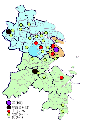 显示原图|下载原图ZIP|生成PPT
图2长三角地区城市网络总关联度
-->Fig. 2Aggregated connectivity of space units in the Yangtze River Delta
-->
Tab. 1
表1
表1长三角地区各空间单元总关联度一览表
Tab. 1Aggregated connectivity of space units in the Yangtze River Delta
| 层级 | 空间单元(总关联度) | ||
|---|---|---|---|
| 市区单元 | 郊区单元 | 县/县级市单元 | |
| 高关联度 | 上海市区(100) | ||
| 较高关联度 | 杭州市区(42),南京市区(38) | ||
| 中关联度 | 宁波市区(26),苏州市区(23),无锡市区(16) | 嘉定(18),松江(15),青浦(13) | |
| 较低关联度 | 南通市区(10),常州市区(9), 嘉兴市区(7),扬州市区(7), 台州市区(6),绍兴市区(6), 湖州市区(5),镇江市区(4), 泰州市区(4) | 金山(9), 奉贤(8),萧山(6), 江宁(4),栖霞(4) | 昆山(9),江阴(5), 常熟(4),宜兴(4), 温岭(4),吴江(4), 张家港(4),崇明(4) |
| 低关联度 | 舟山市区(3) | 余杭(3),六合(3), , et al., et al. | 太仓(3),慈溪(3), , et al., et al. |
新窗口打开
把空间单元按照市区单元,郊区单元,县/县级市单元进行分类,可以发现如下特点:① 市区单元,郊区单元,县/县级市的总关联度依次降低.处于前两个层级的空间单元均为市区单元(上海,南京,杭州的市区),表明市区单元是区域城市网络的核心单元;郊区单元的总关联度最高达到第三层级(嘉定,松江和青浦);县/县级市的总关联度则最高达到第四层级(昆山,江阴等),这体现了不同类型空间单元网络影响力的差异.② 16个市区单元的总关联度呈现明显的梯度格局.上海市区的总关联度遥遥领先,是长三角地区的首位核心;杭州市区和南京市区的总关联度尽管落后于上海市区,但是也明显高于其他空间单元,是长三角地区的次中心城市;宁波市区,苏州市区和无锡市区的总关联度介于第二层级和第四层级之间,是各自省内的次级中心空间单元;舟山市区的总关联度最小.③ 郊区单元的总关联度普遍较高.嘉定(18),松江(15),青浦(13)的总关联度与宁波市区(26),苏州市区(23),无锡市区(16)处于同一水平;金山(9)等空间单元的总关联度则与南通,常州等市区单元处于同一水平.这表明,大都市(上海,南京,杭州)的郊区单元的网络影响力,可以达到区域内地级市市区单元的水平.这也体现了本研究将空间单元划分至区市县的意义所在,如果跳出行政区划的藩篱,将这些郊区单元看作独立的城市功能区域,那么它们和许多地级市市区单元一样,都是区域城市网络中的重要节点.④ 观察总关联度较高的县/县级市单元可以发现,江苏省的空间单元的总关联度普遍高于浙江省,尤其是沪宁线上的县/县级市,其总关联度普遍高于浙江省的县/县级市,说明这些空间单元普遍具有较高的网络影响力,这一区域的城市网络发展更为完善.
以长三角地区网络中的最大关联"上海市区--嘉定"的关联度为100,对数据作标准化处理,然后根据关联度的高低将"城市对"分为5个层级(表2).高关联度是上海市区--嘉定(100);较高关联度包括上海市区--松江(88),上海市区--杭州市区(82)等6组城市对;中关联度包括上海市区--金山(48),上海市区--奉贤(46)等7组城市对.通过观察区域城市网络图,可以发现如下特点(图3):① 上海市域内网络呈现明显的中心地格局,上海市区与市域内郊区单元保持有很高的关联度,同时也与区域内主要单元保持有很高的关联度.② 在江苏省,南京市区是省内的首位核心,它与省内其他市区单元保持紧密关联.沪宁沿线的空间单元,大多同时与南京市区和上海市区保持关联,其中苏州市区和无锡市区是江苏省内的次中心单元.长江以北的空间单元则呈现出明显的本地化倾向,在市域范围内形成明显的中心地网络.③ 在浙江省,杭州市区是省内的首位核心,它与省内其他市区单元保持紧密关联.宁波市区是浙江省内的次中心单元,它与上海市区和杭州市区同时保持紧密关联,其他单元则呈现出很强的本地化特征,在市域范围内形成明显的中心地网络.整体而言,长三角地区内形成了以上海市区为首位核心,以南京市区,杭州市区为区域次中心,以苏州市区,无锡市区,宁波市区为省内次中心的区域城市网络格局.
Tab. 2
表2
表2长三角区城城市网络的关联城市对一览表
Tab. 2Connectivity of city-dyads in the Yangtze River Delta
| 层级 | 关联城市对(网络关联度) |
|---|---|
| 高关联度 | 上海市区--嘉定(100) |
| 较高关联度 | 上海市区--松江(88),上海市区--杭州市区(82),上海市区--青浦(70),上海市区--南京市区(61),上海市区--苏州市区(61),上海市区--宁波市区(59) |
| 中关联度 | 上海市区--金山(48),上海市区--奉贤(46),杭州市区--宁波市区(41),上海市区--无锡市区(38),杭州市区--萧山(27),上海市区--昆山(25),南京市区--苏州市区(25) |
新窗口打开
 显示原图|下载原图ZIP|生成PPT
图3长三角地区城市网络
-->Fig. 3Connectivity of city-dyads in the Yangtze River Delta
-->
3.2.2 基于网络关联度法的网络腹地
由于长三角地区内空间单元较多,本研究挑选出具有代表性的空间单元进行比较.其中,区域内主要空间单元(总关联度位于前三个层级)入选,包括上海市区,南京市区,苏州市区,无锡市区,杭州市区,宁波市区,嘉定和松江,同时在第四层级中选取常州市区,崇明和昆山(在总关联度第四层级单元中选取常州市区,崇明和昆山的主要原因是,用相对关联度法计算这三个单元的网络腹地时,判定系数较大,结果更具有说服力.)
运用网络关联度法,计算长三角地区各个空间单元之间的网络关联度,然后对空间单元i与其他空间单元的网络关联度进行层次聚类,将第一层级,第二层级的单元定义为空间单元i的网络腹地(表3).可以发现如下特点:① 上海市区是大部分空间单元的第一层级关联单元和少量空间单元的第二层级关联单元,表明上海市区是长三角区域的首位核心单元;② 上海市区,南京市区,杭州市区的网络腹地具有相似性,既包括所辖郊区单元(例如上海的嘉定,松江,青浦;南京的江宁,栖霞,六合;杭州的萧山,余杭),也包括区域内总关联度前三个层级的市区单元(杭州市区,宁波市区,南京市区和苏州市区),但是杭州市区和南京市区更倾向于本省的市区单元保持紧密联系(例如南京市区和扬州市区,南通市区和镇江市区保持紧密联系;杭州市区和嘉兴市区,台州市区,绍兴市区和湖州市区保持紧密联系),表现出很强的行政区经济的特点;③ 总关联度处于第三层级的苏州市区,无锡市区,常州市区和宁波市区的网络腹地,与处于第二层级的南京市区,杭州市区的腹地较为类似,也包含所辖郊区单元和区域内主要市区单元,但是关联的省内市区单元较少,表明这些单元在省内的网络影响力要小于南京市区和杭州市区;④ 昆山作为位于苏沪交界位置的单元,首位关联单元是上海市区,次位关联单元是苏州市区和南京市区,表明其网络腹地具有典型的跨区域特征.
Tab. 3
表3
表3长三角地区部分空间单元的网络腹地一览表(网络关联度法)
Tab. 3Hinterworld of some space units in the Yangtze River Delta (Measurement of Connectivity)
| 空间单元 | 网络腹地(网络关联度法) | |
|---|---|---|
| 第一层级关联单元 | 第二层级关联单元 | |
| 上海市区 | 嘉定 | 松江,杭州市区,青浦,南京市区,苏州市区,宁波市区 |
| 嘉定 | 上海市区 | 杭州市区,苏州市区,南京市区 |
| 松江 | 上海市区 | 杭州市区,青浦,苏州市区,南京市区 |
| 崇明 | 上海市区 | 嘉定 |
| 南京市区 | 上海市区 | 苏州市区,江宁,栖霞,六合,无锡市区,常州市区,扬州市区,南通市区,杭州市区,镇江市区 |
| 苏州市区 | 上海市区 | 南京市区,昆山,吴江,无锡市区,常熟,张家港,杭州市区 |
| 无锡市区 | 上海市区 | 南京市区,江阴,苏州市区,宜兴 |
| 常州市区 | 南京市区 | 上海市区,无锡市区,苏州市区 |
| 昆山 | 上海市区 | 苏州市区,南京市区 |
| 杭州市区 | 上海市区 | 宁波市区,萧山,余杭,嘉兴市区,台州市区,绍兴市区,南京市区,湖州市区,苏州市区 |
| 宁波市区 | 杭州市区 | 上海市区,慈溪,余姚,宁海 |
新窗口打开
3.2.3 基于相对关联度法的网络腹地
运用相对关联度法,划分目标空间单元的网络腹地.取标准残差大于1.0的为强关联单元,标准残差小于1.0为弱关联单元,将强关联单元定义为网络腹地(表4).发现如下特点:① 上海市区与郊区单元保持强关联,其网络腹地包括嘉定,松江,青浦,金山,而与其他市区单元(南京市区,杭州市区,宁波市区,南通市区)保持弱关联,这表明,与其他市区单元的总关联度相比,上海市区与这些市区单元的网络关联强度还不够高;② 南京市区和杭州市区与其所辖郊区和省内主要市区单元保持强关联,这些单元构成了它们的网络腹地,而与非同省份的主要市区单元则保持弱关联,包括南京市区与宁波市区,杭州市区保持弱关联,杭州市区与南京市区,南通市区保持弱关联;③ 处于第三层级的苏州市区,无锡市区,常州市区和宁波市区的网络腹地,与处于第二层级的南京市区,杭州市区的腹地较为类似,也包含所辖郊区单元和省内主要市区单元,但是关联的省内市区单元较少,同样表明这些空间单元在省内的网络影响力要小于南京市区和杭州市区;④ 昆山作为位于苏沪交界位置的单元,与苏州市区,上海市区,太仓保持强关联,同样的,作为沪苏边界的崇明,与上海市区,启东保持强关联,它们的网络腹地均具有典型的跨区域特征.
Tab. 4
表4
表4长三角地区部分空间单元的网络腹地一览表(相对关联度法)
Tab. 4Hinterworld of some space units in the Yangtze River Delta (Relative Measurement of Connectivity)
| 空间单元 | 网络腹地(相对关联度法) | |
|---|---|---|
| 强关联单元 | 弱关联单元 | |
| 上海市区 | 嘉定,松江,青浦,金山 | 南京市区,杭州市区,宁波市区,南通市区 |
| 嘉定 | 上海市区 | 南京市区,杭州市区,宁波市区,苏州市区,无锡市区 |
| 松江 | 上海市区 | 南京市区,杭州市区,宁波市区,苏州市区,嘉定,无锡市区 |
| 崇明 | 上海市区,启东 | 南京市区,杭州市区,苏州市区,宁波市区 |
| 南京市区 | 江宁,栖霞,六合,苏州市区,无锡市区,扬州市区,常州市区,浦口,镇江市区,高淳,南通市区,雨花台 | 宁波市区,杭州市区 |
| 苏州市区 | 昆山,吴江,南京市区,常熟,张家港,太仓,无锡市区 | 杭市区州,宁波市区 |
| 无锡市区 | 江阴,南京市区,宜兴,常州市区,苏州市区 | 杭州市区,宁波市区 |
| 常州市区 | 南京市区,无锡市区,金坛,溧阳,宜兴,江阴 | 杭州市区,宁波市区 |
| 昆山 | 苏州市区,上海市区,太仓 | 杭州市区,宁波市区 |
| 杭州市区 | 宁波市区,萧山,余杭,嘉兴市区,绍兴市区,台州市区,湖州市区,富阳 | 南京市区,南通市区 |
| 宁波市区 | 杭州市区,慈溪,余姚,宁海,奉化,象山,舟山市区 | 南京市区,苏州市区 |
新窗口打开
3.2.4 两种测度方法的比较
将两种测度方法得出的结论进行比较,可以发现明显的异同所在.在相同点方面,不管是哪种方法得出的网络腹地,都具有很强的地域性特点,体现在两个方面:第一,行政区经济明显,各个空间单元的网络腹地单元大多分布在各自省域或市域范围内,与其他省市的空间单元的关联度往往相对不高.例如处于第二层级的南京市区,杭州市区的网络腹地,不论用哪种方法,其网络腹地都包含所辖郊区和省内主要城市,而处于第三层级的苏州市区,无锡市区,常州市区和宁波市区,也体现出这一特点.第二,地域邻近性较为明显,这在处于行政边界处的单元表现得尤为明显,例如崇明的网络腹地,用网络关联度法包括上海市区和嘉定,用相对关联度法则包括上海市区和启东,而这三个单元正是在空间上与崇明临近的单元.需要指出的是,以上两个"地域性"的内涵并不相同,前者是行政区经济的体现,在相同省市范围内的单元,尤其是市区与区市县,省会与省内主要城市之间,通常是由于行政区划的原因才保持有强关联;后者则是的市场行为的体现,地理邻近性是公司区位选择的基本原则,这样可以带来降低成本,减少风险,靠近市场和客户等好处.因此,位于行政边界位置的单元,其网络腹地往往体现出较强的跨市跨省联系,例如崇明,昆山等就是很好的例子.
在不同点方面,则要首先聚焦于两种测度方法得出实证结论的区别,这种区别包括:① 上海市区的网络腹地,用网络关联度法得出的结果是所辖郊区单元和区域内主要市区单元(杭州市区,宁波市区,南京市区和苏州市区),而用相对关联度法得出的结果则显示上海市区与郊区单元保持强关联,而与区域内其他市区单元保持弱关联;② 杭州市区,南京市区同样也体现出以上特点,只不过相对关联度法得出的网络腹地中,增加了更多的郊区单元(浦口,高淳,雨花台和富阳),同时也更能体现出省内行政区经济的特点,与此类似的,苏州市区,宁波市区等第三层级的单元也表现出类似特点;③ 处于行政区边界的空间单元,其网络腹地的跨区域特征在相对关联度法的结论中体现的更为明显,例如崇明与启东存在强关联就是很好的例证,这一发现在网络关联度法中被忽略了,其原因在于两个单元之间网络关联度过低,不足以成为区域内的主要关联.但是运用相对关联度法就可以使得这些关联度绝对值不高的单元凸现出来,同样的例子还包括宁波市区与舟山市区,常州市区与江阴,昆山与太仓等.
以上实证结论的差异,能够体现出两种测度方法的主要差异.网络关联度法强调以网络关联度的绝对值为度量指标,因此在其得出的结论中,区域内网络关联度较高的高层级市区单元则更有可能成为大部分空间单元的网络腹地;相对关联度法考虑了之于总关联度的相对关联度,更能够揭示出总关联度较低的空间单元的网络联系格局.与此同时,由于总关联度较低的空间单元往往是郊区,县或县级市单元,而且通常处于行政区边界,因而相对关联度法的结论也往往会更明显的体现出行政区经济特征和跨行政区边界的联系特征.这两种方法的差异实质上也体现出两者的优势和劣势.网络关联度法更能体现网络的主要联系方向和整体格局,有利于把握区域内主要空间单元的网络联系,但是却会忽略绝对值较小,相对值较大的网络联系.而相对关联度法则可以更为深入的揭示区域网络的地域性,尤其是那些总关联度较低的单元(郊区,县,县级市),其网络腹地单元会在前一种方法中被忽略.因此,两者方法互为补充,可以丰富对网络腹地的认识.
实质上,在理论模型分析时已经能够发现两种方法的差别,但是这种差别在现实中表现为何种形式,只有通过实证分析才能够深入了解.通过以上比较已经使我们对两种方法的差别有了更深的理解,而不仅仅局限于理论推演得出的结论.因此,以上实证分析的结论,不仅区分了两种方法的异同所在,更加深了对"中心--腹地"之间辩证关系的理解,即存在绝对联系较强(弱),相对联系较弱(强)的网络格局.只有多角度的分析观察,才能对区域内的中心腹地关系有更深入的了解.
3.2.5 两种测度方法的整合
由于两种测度方法各有优劣,本研究尝试将两种方法相结合.如果用两种方法得出的网络腹地均有某空间单元,那么该单元一定处于网络腹地中,称之为A类腹地单元;如果第一种方法有,第二种方法没有,那么属于关联度绝对值较强,但是相对较弱的单元,称之为B类腹地单元;如有第二种方法有,第一种方法没有,那么属于相对关联度较强,但是绝对值较弱的单元,称之为C类腹地单元.表5中列出了部分空间单元的网络腹地分类情况.可以发现:① A类腹地单元是各个单元的主要网络腹地,由于得到了两种方法的确认,因此这些单元一定处于该单元的网络腹地中;② B类腹地单元以区域内主要市区单元为主,由于以关联度的绝对值为衡量标准,因此更能体现跨省市的网络联系;③ C类腹地单元则大多数是县,县级市或郊区,能够体现出绝对值不高,但是相对值较高的网络联系,行政区经济和地域临近性也有更明显的体现.对比传统基于中心地理论的腹地划分方法可以发现,这一将两种方法结合起来的腹地划分方式,既体现了流动空间中的跨区域网络联系,也与传统腹地一样兼顾了地域性,这样就能够提供多一种视角,来更为深入的理解中心与腹地的辩证关系.
Tab. 5
表5
表5长三角地区部分空间单元的网络腹地分类表
Tab. 5Classification for hinterworld of some space units in the Yangtze River Delta
| 空间单元 | A类腹地单元 | B类腹地单元 | C类腹地单元 |
|---|---|---|---|
| 上海市区 | 嘉定,松江,青浦 | 杭州市区,宁波市区,南京市区,苏州市区 | |
| 嘉定 | 上海市区 | 杭州市区,苏州市区,南京市区 | |
| 松江 | 上海市区 | 杭州市区,青浦,苏州市区,南京市区 | |
| 崇明 | 上海市区 | 嘉定 | 启东 |
| 南京市区 | 苏州市区,江宁,栖霞,六合,无锡市区,扬州市区,常州市区,镇江市区,南通市区 | 上海市区,杭州市区 | 浦口,高淳,雨花台 |
| 苏州市区 | 南京市区,昆山,无锡市区,张家港,常熟,吴江 | 上海市区,杭州市区 | 太仓 |
| 无锡市区 | 南京市区,苏州市区,宜兴,江阴 | 上海市区 | 常州市区 |
| 常州市区 | 南京市区,无锡市区 | 上海市区,苏州市区 | 金坛,溧阳,宜兴,江阴 |
| 昆山 | 上海市区,苏州市区 | 南京市区 | 太仓 |
| 杭州市区 | 宁波市区,萧山,余杭,嘉兴市区,绍兴市区,台州市区,湖州市区 | 上海市区,南京市区,苏州市区 | 富阳 |
| 宁波市区 | 杭州市区,慈溪,余姚,宁海 | 上海市区 | 奉化,象山,舟山市区 |
新窗口打开
其他****也曾经对长三角地区的网络腹地进行过研究[6, 9, 27, 31, 39],表6对划分结果进行了梳理.与本研究相比,已有研究往往以地级市为单元,划分至区市县的研究较少.就结果而言,主要城市的网络腹地单元往往与本研究的A类单元和B类单元部分吻合.以苏州市为例,以往研究结论中其地级市层面的腹地包括上海,南京和无锡,其区市县层面的腹地包括上海市区,南京市区和昆山.而本研究将南京市区,昆山,无锡市区归为A类腹地单元,将上海市区归为B类单元,实质上对这些腹地单元与苏州市区之间的联系赋予了绝对(相对)强弱的属性.本文还将张家港,常熟,吴江归为A类单元,杭州市区归为B类单元,太仓归为C类单元,在区市县层面丰富了对苏州市区腹地单元的认识.再以宁波市为例,在以往研究中,不管是地级市层面还是区市县层面,宁波(市区)的腹地单元均包括上海和杭州(市区).而在本研究中,A类单元除杭州市区外还包括慈溪,余姚和宁海,B类单元为上海市区,C类单元包括奉化,象山和舟山市区,其网络腹地同样具有明确的绝对(相对)强弱的属性.因此,本研究从区市县层面丰富了网络腹地相关研究领域的成果.
Tab. 6
表6
表6已有研究对长三角地区部分城市的网络腹地划分
Tab. 6Classification for hinterworld of some space units in the Yangtze River Delta in the literature
| 空间单元 | 腹地单元 |
|---|---|
| 上海 | 苏州,杭州,南京,宁波 |
| 南京 | 上海,苏州,无锡 |
| 苏州 | 上海,南京,无锡 |
| 苏州市区 | 上海市区,南京市区,昆山 |
| 杭州 | 上海,宁波 |
| 宁波 | 上海,杭州 |
| 宁波市区 | 上海市区,杭州市区 |
新窗口打开
4 结论与讨论
4.1 结论
本研究从城市关联网络的视角,以企业分支数据为基础,以长三角地区16个核心城市的区市县单元为研究对象,将两种网络腹地的划分方式----网络关联度法和相对关联度法进行了实证分析和比较.结果发现,网络关联度法以关联度的绝对值为度量指标,区域内高层级市区单元更有可能成为大部分空间单元的网络腹地;相对关联度法则能够揭示出总关联度较低的空间单元的网络联系格局.与此同时,由于总关联度较低的空间单元往往是郊区,县或县级市单元,而且通常处于行政区边界,因而相对关联度法的结论也会更明显的体现出行政区经济和跨行政区边界联系的特征.综合来看,网络关联度法更能体现区域网络的主要格局,有利于把握区域内主要空间单元的网络联系,但是却会忽略绝对值较小,相对值较大的网络联系;而相对关联度法则可以更为深入的揭示区域网络的地域性,尤其是那些总关联度较低的单元(郊区,县,县级市).在此基础上,本研究尝试将两种方法结合起来,既能够体现流动空间中的跨区域网络联系,也能兼顾腹地的地域性.城市网络腹地的划分具有积极的实践意义.对于长三角地区这一国家级城市群而言,要想确定合理的区域城市体系,实现各城市的协同发展,就需要对区域城市网络格局,特别是对各个城市的职能分工和影响范围有深入的了解.本研究提供的方法和结论,能够为划定城市群的影响边界,特别是上海,南京,杭州等大都市的影响范围提供参考.在网络腹地划分的基础上,可以通过引入联系方向,行业部类,价值链环节等变量进一步分析区域内各城市之间的相互关系,这为深入了解区域城市体系格局提供了新的视角和方法,从而为制定区域协同发展政策提供借鉴.
4.2 讨论
本研究仍然存在一定局限性.由于城市网络研究是以"流动空间"理论为基础的,因此需要选择最能够代表"流动空间"内涵(商品,资金,信息和人员流动)的关系数据进行分析.本研究选取企业分支数据,一方面是因为其综合表征了各类生产要素的流动,具有较好的代表性;另一方面是由于其数据是可以获取的,因此可以加以推广应用.但是数据自身的缺陷也是不能否认的,包括在代表性方面更多体现的是资金和信息流,在商品流和人员流方面的代表性稍弱,忽略了企业间的间接联系(由于企业间贸易数据难以获得)等.但是权衡数据的代表性和可获得性,企业分支数据仍然是研究城市网络的良好的数据源.此外,运用总部分支法进行分析也存在一定局限性,包括更多强调总部与分支的联系,忽略了企业分支之间的联系,未考虑企业规模和产值等要素,关键词的选取会影响数据精度等.但是考虑到企业总部与分支的联系通常远强于分支之间的联系,计算方法便于处理全行业大量数据,可以进一步研究网络联系方向等优点,总部分支法仍然是城市网络研究领域的主流方法,具有一定合理性和较强的可行性.随着城市网络理论和信息技术的不断发展,相信会有更好的数据源和分析方法不断涌现,这也是后续研究的重要方向.中心与腹地的关系,是一个复杂而需要谨慎回答的问题.网络腹地划分的两种方法,其数理模型的区别实质上体现了学术界对于"中心--腹地"关系的辩证理解,而实证分析的结论则丰富了我们对于网络腹地的认识,即存在绝对联系较强(弱),相对联系较弱(强)的网络格局,这为我们提供了描述和分析"中心--腹地"关系的新视角和新途径.在全新的时代背景和理论体系下,只有通过多角度的分析观察,将多种方法相结合,才能对区域内的中心腹地关系有更深入的理解,这也是未来研究值得关注的重要领域.
The authors have declared that no competing interests exist.
参考文献 原文顺序
文献年度倒序
文中引用次数倒序
被引期刊影响因子
| [1] | 以辐射强度最大法和电话流首位 对地法为基础开发研制了城镇势力圈分析计算机系统HAP。并以上虞市为例分析了势力圈的空间特征和动态变化。揭示了势力圈所具有的空间特征 ,包括势力圈边界由圆弧段构成 ;圆弧的位置及凹凸关系由相邻城镇的规模大小决定 ;势力圈之间存在并存、包含和竞争三种关系。 以辐射强度最大法和电话流首位 对地法为基础开发研制了城镇势力圈分析计算机系统HAP。并以上虞市为例分析了势力圈的空间特征和动态变化。揭示了势力圈所具有的空间特征 ,包括势力圈边界由圆弧段构成 ;圆弧的位置及凹凸关系由相邻城镇的规模大小决定 ;势力圈之间存在并存、包含和竞争三种关系。 |
| [2] | . 文章以郑州市为例,主要研究了区域性中心城市辐射力指标体系,采 用层次分析法对所研究指标进行了赋值.以此为基础,用裂点法对郑州与周边相邻、相关城市的不同城市要素相互作用的范围进行了分析.找出了郑州作为区域性中 心城市的影响区域、发展优势和不足,并就提高郑州辐射力的途径、措施进行了研究. . 文章以郑州市为例,主要研究了区域性中心城市辐射力指标体系,采 用层次分析法对所研究指标进行了赋值.以此为基础,用裂点法对郑州与周边相邻、相关城市的不同城市要素相互作用的范围进行了分析.找出了郑州作为区域性中 心城市的影响区域、发展优势和不足,并就提高郑州辐射力的途径、措施进行了研究. |
| [3] | 选取衡量城市实力的四类指标, 用聚类分析方法,确定与广州处于同一级别的中心地城市;用主成分分析法提取影响主因子,采用影响力指数计算2004年广州腹地的断裂点,并结合流态分析, 将广州城市腹地划分为包括广东、广西、湖南、云南、贵州、四川、海南在内的直接腹地以及包括重庆、江西、福建和湖北在内的竞争腹地。其范围与泛珠江三角洲 的省区基本相当。然后用同样方法计算广州1985、1994年的断裂点,比较改革开放近20年来广州城市腹地的变化,分析了变化的原因;最后,探讨了未来 广州腹地拓展的策略,并认为推进泛珠江三角洲一体化建设对拓展广州腹地具有重要意义。 选取衡量城市实力的四类指标, 用聚类分析方法,确定与广州处于同一级别的中心地城市;用主成分分析法提取影响主因子,采用影响力指数计算2004年广州腹地的断裂点,并结合流态分析, 将广州城市腹地划分为包括广东、广西、湖南、云南、贵州、四川、海南在内的直接腹地以及包括重庆、江西、福建和湖北在内的竞争腹地。其范围与泛珠江三角洲 的省区基本相当。然后用同样方法计算广州1985、1994年的断裂点,比较改革开放近20年来广州城市腹地的变化,分析了变化的原因;最后,探讨了未来 广州腹地拓展的策略,并认为推进泛珠江三角洲一体化建设对拓展广州腹地具有重要意义。 |
| [4] | . <p>一个明确而又合理的城市腹地范围, 是保证一定区域内各城市实现合理功能整合的关 键, 也是对城市经济区进行各项研究的基础。通过构建衡量城市综合规模的指标体系, 运用 主成分分析法计算中国283 个地级及以上城市的规模值。在GIS 软件支持下, 将中国划分为 5 km×5 km 的格网, 利用场强模型, 对2004 年283 个地级及以上城市的腹地进行了划分, 比较腹地的范围及相互关系, 并与省域和市域行政范围进行了叠合分析, 实现了城市腹地测 定、分析的可视化。结果表明: 中国地级及以上城市规模值差异较大, 最大和最小城市规模 相差达284 倍。场强值分布呈现明显的东、中、西递减的分异特征, 与经济发展的梯度差异 一致。中、东部的城市影响力的弱势区域全部分布在省域交界地带, 在场强值大于12 的级别 上, 东、中部城市的场强影响范围连成一片。各城市腹地范围相差亦较大, 最大和最小城市 腹地相差达5488 倍。各城市在地理位置上不一定位于其腹地的几何中心, 偏移比较大的城市 往往成对分布。城市腹地与省域行政范围吻合度较差, 根据腹地在市域行政范围内的面积比 例, 将城市分为4 类, 并提出相应的空间发展策略。依据腹地的分析结果将全国划分为3 个 一级城市经济区、11 个二级区和38 个三级区。</p> . <p>一个明确而又合理的城市腹地范围, 是保证一定区域内各城市实现合理功能整合的关 键, 也是对城市经济区进行各项研究的基础。通过构建衡量城市综合规模的指标体系, 运用 主成分分析法计算中国283 个地级及以上城市的规模值。在GIS 软件支持下, 将中国划分为 5 km×5 km 的格网, 利用场强模型, 对2004 年283 个地级及以上城市的腹地进行了划分, 比较腹地的范围及相互关系, 并与省域和市域行政范围进行了叠合分析, 实现了城市腹地测 定、分析的可视化。结果表明: 中国地级及以上城市规模值差异较大, 最大和最小城市规模 相差达284 倍。场强值分布呈现明显的东、中、西递减的分异特征, 与经济发展的梯度差异 一致。中、东部的城市影响力的弱势区域全部分布在省域交界地带, 在场强值大于12 的级别 上, 东、中部城市的场强影响范围连成一片。各城市腹地范围相差亦较大, 最大和最小城市 腹地相差达5488 倍。各城市在地理位置上不一定位于其腹地的几何中心, 偏移比较大的城市 往往成对分布。城市腹地与省域行政范围吻合度较差, 根据腹地在市域行政范围内的面积比 例, 将城市分为4 类, 并提出相应的空间发展策略。依据腹地的分析结果将全国划分为3 个 一级城市经济区、11 个二级区和38 个三级区。</p> |
| [5] | . 提出从"城市质量"和"吸引惯 性指数"两个方面改进城市引力模型,并以湖南省14个城市作为研究对象,测算了研究区各城市在2002、2007、2010年3个时间点彼此间的吸引力。 同时基于层次聚类法分析了14个城市的经济区空间格局及其演变,结果表明:①2002年湖南省可分为长株潭经济区、环洞庭湖经济区、湘中南经济区和湘西经 济区;②2007年和2010年相比于2002年则增加了一个离心经济区。研究结果可为城市引力测算及区域城市间经济协同发展规划提供参考。 . 提出从"城市质量"和"吸引惯 性指数"两个方面改进城市引力模型,并以湖南省14个城市作为研究对象,测算了研究区各城市在2002、2007、2010年3个时间点彼此间的吸引力。 同时基于层次聚类法分析了14个城市的经济区空间格局及其演变,结果表明:①2002年湖南省可分为长株潭经济区、环洞庭湖经济区、湘中南经济区和湘西经 济区;②2007年和2010年相比于2002年则增加了一个离心经济区。研究结果可为城市引力测算及区域城市间经济协同发展规划提供参考。 |
| [6] | |
| [7] | . |
| [8] | . An Achilles heel of world city research is the lack of available data that quantifies the changing positions of cities in the world city system and hierarchy. This paper begins to address this poverty of data by showing that appropriate data can be identified and analysed to study relations between world cities. The paper contains three distinct sections which deal with the practicalities of the generation, collection and storage of relational data. First, the necessity of standardization, to make comparisons between world cities' relations credible, is advanced. Secondly, three different measurement methodologies (of increasing power, but with specific functions) are advanced (surrogate, labour and organizational), and illustrated through three pieces of research, to specify a world city's external relations. Thirdly, both practical ways of organizing research to obtain relational data, and a World Wide Web initiative designed to store and make available data across the globe, are outlined. |
| [9] | 城市群不仅是地理上的相邻性, 更重要的是经济上的关联性,而企业是城市关联网络的"作用者"。采用企业关联网络的分析方法,在全球、国家、地区三个空间层面上,揭示长三角地区作为国家 级城市群和长江中游地区作为区域性城市群的主要异同所在,解析两个城市群在全球和国家体系中的网络关联格局、以及城市群内部的网络关联格局。 城市群不仅是地理上的相邻性, 更重要的是经济上的关联性,而企业是城市关联网络的"作用者"。采用企业关联网络的分析方法,在全球、国家、地区三个空间层面上,揭示长三角地区作为国家 级城市群和长江中游地区作为区域性城市群的主要异同所在,解析两个城市群在全球和国家体系中的网络关联格局、以及城市群内部的网络关联格局。 |
| [10] | . |
| [11] | . ABSTRACT Book description: 'Large polycentric city-regions pose perplexing problems to social scientists and policy-makers. Not only do they represent complex socio-economic systems in their own right, but they also increasingly function as the main locational anchors of wider globalization processes. This book provides a masterful analysis of these issues, with a particular focus on the emergence, dynamics, and planning of polycentric city-regions in contemporary Europe' Allen Scott of University of California, and author of Global City-Regions. A new 21st century urban phenomenon is emerging: the networked polycentric mega-city region. Developed around one or more cities of global status, it is characterized by a cluster of cities and towns, physically separate but intensively networked in a complex spatial division of labour. This book describes and analyses eight such regions in North West Europe. For the first time, this work shows how businesses interrelate and communicate in geographical space - within each region, between them, and with the wider world. It goes on to demonstrate the profound consequences for spatial planning and regional development in Europe - and, by implication, other similar urban regions of the world. The Polycentric Metropolis introduces the concept of a mega-city region, analyses its characteristics, examines the issues surrounding regional identities, and discusses policy ramifications and outcomes for infrastructure, transport systems and regulation. Packed with high quality maps, case study data and written in a clear style by highly experienced authors, this will be an insightful and significant analysis suitable for professionals in urban planning and policy, environmental consultancies, business and investment communities, technical libraries, and students in urban studies, geography, economics and town/spatial planning. |
| [12] | . |
| [13] | . An Achilles heel of world city research is the lack of available data that quantifies the changing positions of cities in the world city system and hierarchy. This paper begins to address this poverty of data by showing that appropriate data can be identified and analysed to study relations between world cities. The paper contains three distinct sections which deal with the practicalities of the generation, collection and storage of relational data. First, the necessity of standardization, to make comparisons between world cities' relations credible, is advanced. Secondly, three different measurement methodologies (of increasing power, but with specific functions) are advanced (surrogate, labour and organizational), and illustrated through three pieces of research, to specify a world city's external relations. Thirdly, both practical ways of organizing research to obtain relational data, and a World Wide Web initiative designed to store and make available data across the globe, are outlined. |
| [14] | . Information on air passenger flows is potentially a prime data source for assessing spatial patterns in the world city network, but previous analyses of this issue have been hampered by inadequate and/or partial data. The ensuing analytical deficiencies have reduced the overall value of these analyses. Therefore, this paper examines how some of these deficiencies might be rectified. First, it reviews the rationale for using airline data to analyse the world city network. Secondly, it assesses the problems encountered by previous research. The third section elaborates on the construction of a global intercity matrix based on the so-called Marketing Information Data Transfer database and explains how this matrix can circumvent some previously identified problems. |
| [15] | . A number of researchers have recently tried to map the contours of a transnational urban network. Although these empirical studies have great merits in making a closer connection to theoretical ideas on a genuine urban network, they sometimes fail to recognise that the whole idea of cities as 'nodes' in a transnational urban network is a heuristic at best. To assess this underdeveloped analytical connection, a taxonomy of dominant empirical and theoretical approaches is constructed. Contrasting both taxonomies reveals a mismatch between theory and measurement. This mismatch is addressed in more detail through four separate but entwined examples of conceptual conflation: a lack of rigour in the employed terminologies; inappropriate discussions of results against the background of other concepts; the inadequate delineation of the urban area; and, the limited analytical value of infrastructure-based analyses. |
| [16] | This classic work chronicles how New York, London, and Tokyo became command centers for the global economy and in the process underwent a series of massive and parallel changes. What distinguishes Sassen's theoretical framework is the emphasis on the formation of cross-border dynamics through which these cities and the growing number of other global cities begin to form strategic transnational networks. All the core data in this new edition have been updated, while the preface and epilogue discuss the relevant trends in globalization since the book originally came out in 1991. |
| [17] | . Space syntax is a technique for measuring the relative accessibility of different locations in a spatial system which has been loosely partitioned into convex spaces. These spaces are approximated by straight lines, called axial lines, and the topological graph associated with their intersection is used to generate indices of distance, called integration, which are then used as proxies for accessibility. The most controversial problem in applying the technique involves the definition of these lines. There is no unique method for their generation; hence different users generate different sets of lines for the same application. In this paper we explore this problem, arguing that to make progress, there need to be unambiguous, agreed procedures for generating such maps. The methods we suggest for generating such lines depend on defining viewsheds, called isovists, which can be approximated by their maximum diameters, these lengths being used to form axial maps similar to those used in space syntax. We propose a generic algorithm for sorting isovists according to various measures, approximating them by their diameters and using the axial map as a summary of the extent to which isovists overlap (intersect) and are accessible to one another. We demonstrate our techniques for the small French town of Gassin used originally by Hillier and Hanson in a 1984 book to illustrate the theory, exploring different criteria for sorting isovists, and generating different axial maps by changing the level of resolution. |
| [18] | . |
| [19] | . Abstract Through an exploratory analysis of the world city network, we confront the dearth of studies on inter-urban networks on a global scale. In the first section, we outline how a formal theoretical specification of the world city network as a social network has guided an extensive data gathering effort. Through this specification it becomes possible to apply standard techniques of network analysis to world cities. In the second section we outline a framework within which to explore the complex patterns that arise from the formal specification of the world city network. The conjectural use of connectivity, world city cliques and clique-by-clique comembership is then used in the third section as the input to an exploratory analysis of the measures of connectivity at different thresholds. The main findings are the two city dominance of the New York鈥揕ondon dyad, and the observation that inter-city links at the global level retain an important regional dimension. Exemplary cases are the thorough interrelatedness of North American, Pacific Asian and European world cities. |
| [20] | . Abstract Sassen's identification of global cities as “strategic places” is explored through world city network analysis. This involves searching out advanced producer service (APS) firms that constitute “strategic networks,” from whose activities strategic places can be defined. Twenty-five out of 175 APS firms are found to be strategic, and from their office networks, 45 cities out of 526 are designated as strategic places. A measure of “strategicness” of cities is devised, and individual findings from this are discussed by drawing on existing literature about how APS firms use specific cities. A key finding shows that New York and London have different levels of strategicness, and this is related to the former's innovation prowess and the latter's role in global consumption of services. Other cases of strategicness discussed in terms of the balance between production and consumption of APSs are Beijing, Hong Kong, and Shanghai; Palo Alto; Mexico City; Johannesburg; and Dubai and Frankfurt. |
| [21] | . Although there is a general consensus on which are the leading world cities, there is no agreed-upon roster covering world cities below the highest level. This paper reports the construction of an inventory of world cities based upon their level of advanced producer services. Global service centres are identified and graded for accountancy, advertising, banking/finance and law. Aggregating these results produces a roster of 55 world cities at three levels: 10 Alpha world cities, 10 Beta world cities and 35 Gamma world cities. These are found to be largely geographically concentrated in three “globalization arenas”, northern America, western Europe and Pacific Asia. |
| [22] | . In consideration of the local-global nexus it is commonplace to emphasise multiple 'locals'; in this paper, we introduce multiple 'globals' in the sense of differences in firm's globalisation strategies. Building upon the collection of a unique set of data showing advanced producer service office networks for 46 major firms in 55 world cities, the major dimensions of variability in this geography are explored using principal components analyses. An R-mode analysis shows similarities in firm's location patterns and 14 distinctive cross-city profiles of firms are identified. A key finding is that different producer services tend to have different cross-city profiles. A Q-mode analysis groups world cities in terms of similar corporate locations and 9 corporate service mixes are identified. A key finding is that most cities group into regional or interregional clusters; London and New York (but not Tokyo) are exceptional in forming their own distinctive 'global city' dimension. The overall conclusion is that world city formation, a core process of globalisation, has created a rich and informative geographical complexity. Since there is order to the complexity, the paper finishes with a multifarious research agenda derived from this first comprehensive, comparative analysis of world cities. |
| [23] | . Drawing on previous specification and measurement of the world city network, this paper develops an exploratory research design using principal components analyses. Multiple solutions are used to explore the structure of a matrix defined by 123 cities and 100 global service firms in which the cells indicate the value of the firm's office in that city. Principal components analysis produces clusters of cities based upon similar profiles of service firms. Using 13 separate analyses, the main finding is a prime structure consisting of Outer cities, US cities, Pacific Asian cities, Euro-German cities and Old Commonwealth cities. Other secondary structures are also found. The end-result is a new geography of globalisation as indicated by configurations of the world city network. |
| [24] | . @misc{4303836, author = {Taylor, PJ and Derudder, Ben and Hoyler, M and Ni, P and Witlox, Frank}, keyword = {globalization,world city network,city-dyads,advanced producer services,China cities}, language = {eng}, pages = {16}, publisher = {Loughborough University. Department of Geography, Globalization and World Cities Study Group and Network}, series = {GaWC Research Bulletin}, title = {City-dyad analyses of China's integration into the World City Network}, url = {http://www.lboro.ac.uk/gawc/rb/rb407.html}, volume = {407}, year = {2012}, } |
| [25] | . Taylor P. J. and Aranya R. A global 'urban roller coaster'? Connectivity changes in the world city network, 2000-2004, Regional Studies. A network model is used to assess the nature of change in intercity relations from 2000 to 2004. Data are collected for 2004 on the office networks of the same global service firms that were used to describe global connectivities for 315 cities in 2000. This allows a new cross-sectional geography of connectivities to be produced for 2004, and for changes in connectivities between 2000 and 2004 to be computed. Simple visualization and statistical techniques are used to explore the data. A distinction is made between 'normal change' and 'exceptional change' and only two cases of the latter are definitely identified: cities in both the USA and sub-Saharan Africa are generally losing global connectivity in relation to the rest of the world. Thus 'normal change' predominates and the paper concludes that contemporary intercity change does not correspond to Castells' image of an 'urban roller coaster'. [image omitted] Taylor P. J. et ARANYA R. Des 'montagnes russes urbaines' mondiales? Les changements de la connectivite du reseau de grandes villes a l'echelle mondiale, Regional Studies. On se sert d'un modele de reseau pour evaluer le caractere du changement dans les rapports intervilles de 2000 a 2004. On recueillit des donnees pour 2004 aupres des reseaux de bureau pour les services aux entreprises mondialises qui ont ete employes afin de decrire la connectivite mondiale de 315 grandes villes en 2000. Cela permet la realisation d'une nouvelle geographie transversale de la connectivite pour 2004 et le calcul des changements de la connectivite entre 2000 et 2004. On emploie de simples techniques de visualisation et statistiques pour examiner les donnees. On fait une distinction entre le 'changement normal' et le 'changement exceptionnel', et on n'identifie indubitablement que deux cas de ce dernier: en regle generale, les grandes villes aux Etats-Unis et en Afrique-Noire perdent de la connectivite mondiale par rapport au reste du monde. Ainsi, le 'changement normal' predomine et on conclut que le changement interville contemporain ne correspond pas a l'image des 'montagnes russes urbaines' d'apres Castells. Mondialisation Grandes villes a l'echelle mondiale Reseau de villes a l'echelle mondiale Changement mondial Taylor P. J. und Aranya R. 'Eine weltweite ,urbane Achterbahn'? Anderungen im Weltstadt-Netzwerk, 2000-04, Regional Studies. Mit Hilfe eines Netzwerkmodells bewerten wir die Art der Veranderungen in zwischenstadtischen Beziehungen im Zeitraum von 2000 bis 2004. Erfasst wurden Daten des Jahres 2004 uber die Niederlassungsnetzwerke derselben weltweit tatigen Dienstleistungsfirmen, die im Jahr 2000 zur Beschreibung der weltweiten Verknupfungen fur 315 Stadte genutzt wurden. Hierdurch konnte eine neue, sektionsubergreifende Geografie der Verknupfungen fur 2004 erstellt werden, und die Veranderungen der Verknupfungen zwischen 2000 und 2004 liessen sich berechnen. Zur Analyse der Daten kamen einfache Visualisierungs- und Statistiktechniken zum Einsatz. Unterschieden wurde zwischen einer ,einfachen' und einer ,aussergewohnlichen' Veranderung; von der letzteren liessen sich nur zwei Falle definitiv identifizieren: Die Stadte in den USA und im subsaharischen Afrika verlieren generell an weltweiten Verknupfungen im Verhaltnis zum Rest der Welt. Die ,normalen' Veranderungen herrschen also vor, und wir ziehen den Schluss, dass zeitgenossische zwischenstadtische Veranderungen nicht Castells' Bild einer ,urbanen Achterbahn' entsprechen. Globalisierung Weltstadte Weltstadt-Netzwerk Globale Veranderung Taylor P. J. y Aranya R. Una 'montana rusa urbana' global? Cambios de conexion en la Red Urbana Mundial, 2000-04, Regional Studies. Con ayuda de un modelo de redes evaluamos la naturaleza de cambio en las relaciones interurbanas de 2000 a 2004. Recogimos datos para 2004 en las redes de oficinas de las mismas empresas de servicios globales que se utilizaron para describir las conexiones mundiales para 315 ciudades en 2000. Esto nos permite crear una nueva geografia transversal de conexiones para 2004 y calcular los cambios en las conexiones entre 2000 y 2004. Para explorar estos datos utilizamos tecnicas sencillas de visualizacion y estadistica. Se distingue entre 'cambio normal' y 'cambio excepcional' y solo dos casos de este ultimo se han identificado de modo definitivo: las ciudades en los Estados Unidos y en Africa subsahariana estan perdiendo normalmente conexion global con relacion al resto del mundo. De este modo predomina el 'cambio normal'. Terminamos argumentando que el cambio interurbano contemporaneo no se corresponde con la imagen que da Castells de un 'montana rusa urbana'. Globalizacion Ciudades del mundo Red urbana mundial Cambio global |
| [26] | [EB/OL]. [ |
| [27] | . 伴随着经济全球化的进程,长三角区域越来越纳入全球经济网络,城市体系演化表现出新的特征.从经济全球化的视角,采用关联网络和价值区段的分析方法,揭示了长三角区域的城市体系演化的3个主要特征:①上海作为长三角区域的"门户城市",发挥向外连接全球网络和向内辐射区域腹地的"两个扇面"作用:②长三角区域内部的城市之间关联网络具有层级和地域的双重属性,企业是城市之间关联网络的"作用者":③经济全球化进程中的国际劳动分工导致长三角区域的城市体系正在从以"行业类型"为特征的空间经济结构转变成为以"价值区段"为特征的空间经济结构.<dt><strong><t>Abstract:</t></strong></dt><dd>In the process of economic globalization, development of Yangtze River Delta Region has been increasingly linked with global economy, leading to new trends in the transformation of urban system.This paper discusses economic global-ization and urban transformation, using approaches of interlocking network and val-ue-added hierarchy.Three features have been identified.First, Shanghai is playing the role of gateway city with both outward orientation to the global network and inward orientation to the regional hinterland.Secondly, within the region, firms are the agents to interlock cities into a network of both hierarchy and hinterland dimen-sions.Thirdly, spatial division of labor in the process of economic globalization has brought about the transformation of spatial configuration of regional economy from an industrial composition into a value-added hierarchy. . 伴随着经济全球化的进程,长三角区域越来越纳入全球经济网络,城市体系演化表现出新的特征.从经济全球化的视角,采用关联网络和价值区段的分析方法,揭示了长三角区域的城市体系演化的3个主要特征:①上海作为长三角区域的"门户城市",发挥向外连接全球网络和向内辐射区域腹地的"两个扇面"作用:②长三角区域内部的城市之间关联网络具有层级和地域的双重属性,企业是城市之间关联网络的"作用者":③经济全球化进程中的国际劳动分工导致长三角区域的城市体系正在从以"行业类型"为特征的空间经济结构转变成为以"价值区段"为特征的空间经济结构.<dt><strong><t>Abstract:</t></strong></dt><dd>In the process of economic globalization, development of Yangtze River Delta Region has been increasingly linked with global economy, leading to new trends in the transformation of urban system.This paper discusses economic global-ization and urban transformation, using approaches of interlocking network and val-ue-added hierarchy.Three features have been identified.First, Shanghai is playing the role of gateway city with both outward orientation to the global network and inward orientation to the regional hinterland.Secondly, within the region, firms are the agents to interlock cities into a network of both hierarchy and hinterland dimen-sions.Thirdly, spatial division of labor in the process of economic globalization has brought about the transformation of spatial configuration of regional economy from an industrial composition into a value-added hierarchy. |
| [28] | . 近年来,中国城市之间的联系越 来越密切,基于各种"流"的联系正在促使一个新的中国城市网络格局的形成。在回顾国内外研究城市之间相互联系的相关文献和借鉴世界城市网络研究方法的基础 上,试图通过全国主要金融服务业企业布局对中国城市网络进行定量分析。研究结果表明:中国城市的网络连接度与城市的重要性有关,城市在网络中的连接率随城 市的重要性下降而递减;中国城市网络具有区域特性,基本形成了环渤海、长三角、珠三角等"三大两小"五个城市区域;北京、上海、深圳是网络中最重要的节 点,共同构成了基于金融业的中国城市网络的基本框架。 . 近年来,中国城市之间的联系越 来越密切,基于各种"流"的联系正在促使一个新的中国城市网络格局的形成。在回顾国内外研究城市之间相互联系的相关文献和借鉴世界城市网络研究方法的基础 上,试图通过全国主要金融服务业企业布局对中国城市网络进行定量分析。研究结果表明:中国城市的网络连接度与城市的重要性有关,城市在网络中的连接率随城 市的重要性下降而递减;中国城市网络具有区域特性,基本形成了环渤海、长三角、珠三角等"三大两小"五个城市区域;北京、上海、深圳是网络中最重要的节 点,共同构成了基于金融业的中国城市网络的基本框架。 |
| [29] | . Globalization has renewed interest in the place and role of cities in the international system. Recent literature proposes that the fate of cities (and their residents) has become increasingly tied to their position in international flows of investment and trade. Data on the branch locations of the world’s 500 largest multinational enterprises in 2000 are subjected to two broad types of network analytic techniques in order to analyze the “world city system.” First, 3,692 cities are analyzed in terms of three measures of point centrality. Second, blockmodeling techniques are employed to generalize further about the positions and roles played by cities in the system. These techniques are used to trace out the structure of the world city system, locate cities in the context of a global urban hierarchy, and explore the degree to which this diverges from a simple one‐to‐one matching of cities onto nation‐states in the world system. Sociology |
| [30] | . abstractToday the existence of the ‘network society’ is often asserted. However, there is a lack of empirical understanding of what these networks actually are, especially concerning networks between cities worldwide. Therefore, this study contributes to economic geography because it is empirically based on actual data concerning global multinational networks. Based on this, the network characteristics of temporality, structure, scale, competition and performance are explored using network analysis techniques. In the temporal study the historical process of network formation is discussed. In the study on structure the contemporary worldwide corporate network is empirically exposed. In this, the hierarchies, interdependencies and distribution of the network is revealed. For instance, it is demonstrated that the majority of corporate activity takes place ‘between’ cities and not ‘within’ their municipal boundaries. The study on corporate scale shows how differences in firm types (global, European and Dutch), will reveal variations in city hierarchies and interdependencies. In the competition study a new measure has been introduced to assess competition based on the economic ties between cities. The study on network performance shows that although the reach of corporate activity between nations is global, the scope of this activity remains particularly constrained between nations of the developed world. Hence, contrary to popular belief, the corporate world is not flat but highly polarized. Based on this, it is shown that network hegemony is strongly associated with the global competitivity levels of nations. This study demonstrates the utility of network analysis to understand cities within an increasingly global world - in which the methods, techniques and results can be of interest to scientists, policymakers, planners and developers alike.text |
| [31] | . 以地域间企业分支机构数据为基础,采用从理论引介到实证检验的研究方法,通过分析长三角区域的城市问企业网络,描述城市间的流量、网络的结节性等特征,并度量了区域多核心化的趋势,利用网络连接度对中心城的腹地范围进行划分。文章的主要创新性体现在:以企业为分析客体,从实证的角度完成了长三角区域连线、节点、面域的网络特征描述。研究结果显示,网络节点方面长三角区域呈现出明显极化的等级特征,地区间网络流量方面各地往上海流向非常明显,并具有多核化的趋势;腹地方面,大多数中心城的腹地与其所在地区的行政区划边界不一致,上海、杭州和南京属于区域网络的极核,其腹地均超过了行政区划的范围。 . 以地域间企业分支机构数据为基础,采用从理论引介到实证检验的研究方法,通过分析长三角区域的城市问企业网络,描述城市间的流量、网络的结节性等特征,并度量了区域多核心化的趋势,利用网络连接度对中心城的腹地范围进行划分。文章的主要创新性体现在:以企业为分析客体,从实证的角度完成了长三角区域连线、节点、面域的网络特征描述。研究结果显示,网络节点方面长三角区域呈现出明显极化的等级特征,地区间网络流量方面各地往上海流向非常明显,并具有多核化的趋势;腹地方面,大多数中心城的腹地与其所在地区的行政区划边界不一致,上海、杭州和南京属于区域网络的极核,其腹地均超过了行政区划的范围。 |
| [32] | 城市群不仅是地理上的相邻性,更重要的是经济上的关联性,而企业 是城市关联网络的“作用者”。在全球、国家和地区3个空间层面上,采用企业关联网络的分析方法,揭示了京津冀、长三角和珠三角地区的城市体系的主要异同所 在。北京、上海、广州和深圳既是全国的核心城市,也分别是3个地区的“门户城市”,发挥向外连接全球经济网络和向内辐射区域腹地的“两个扇面”作用。3个 地区的门户城市、主要城市和一般城市在各个层面的关联网络中都形成明显的梯度格局。在地区层面上,珠三角地区的城市体系以两个核心和单一层级(省域)为特 征,显然不同于京津冀地区和长三角地区的城市体系以单一核心和两个层级(区域和省域)为特征。 城市群不仅是地理上的相邻性,更重要的是经济上的关联性,而企业 是城市关联网络的“作用者”。在全球、国家和地区3个空间层面上,采用企业关联网络的分析方法,揭示了京津冀、长三角和珠三角地区的城市体系的主要异同所 在。北京、上海、广州和深圳既是全国的核心城市,也分别是3个地区的“门户城市”,发挥向外连接全球经济网络和向内辐射区域腹地的“两个扇面”作用。3个 地区的门户城市、主要城市和一般城市在各个层面的关联网络中都形成明显的梯度格局。在地区层面上,珠三角地区的城市体系以两个核心和单一层级(省域)为特 征,显然不同于京津冀地区和长三角地区的城市体系以单一核心和两个层级(区域和省域)为特征。 |
| [33] | |
| [34] | . . |
| [35] | |
| [36] | . Pain K. Examining 'core-periphery' relationships in a global city-region: the case of London and South East England, Regional Studies. This paper examines the interdependencies between the London 'core' and the South East England 'Mega-City Region'. London's description as a monocentric city in the European Spatial Development Perspective belies functional connectivities that make a wide area to the west of the capital a web of dense inter-urban linkages. How are advanced business services creating a functional geography that differs from binary territorial representations? What are the implications for policy and theorization? This paper addresses these questions with specific reference to South East England and the 'core-periphery' thesis. [image omitted] Pain K. Examiner le rapport 'centre-peripherie' dans une cite-region mondiale: etude de cas de Londres et de l'Angleterre du Sud-Est, Regional Studies. Cet article cherche a examiner les interdependances entre le 'centre', a savoir Londres, et la mega-cite-region' de l'Angleterre du Sud-Est. Dans le European Spatial Development Perspective (perspective sur le developpement geographique europeen) la description de Londres comme ville mono-centrique dissimule les connectivites fonctionnelles qui font d'une grande zone a l'ouest de la capitale un grand reseau de liens interurbains. Comment les services aux entreprises haut de gamme peuvent-ils creer une geographie fonctionnelle qui se distingue des representations territoriales binaires? Quelles sont les implications quant a la politique et a la theorisation? Cet article cherche a aborder ces questions-la specifiquement en ce qui concerne l'Angleterre du Sud-Est et la these 'centre-peripherie'. Mega-cite-region Polycentrisme-monocentrisme Centre-peripherie Services aux entreprises haut de gamme Binaire Specialisation fonctionnelle Pain K. Untersuchung der 'Kern-Peripherie'-Beziehungen in einer globalen Stadtregion: der Fall von London und Sudostengland, Regional Studies. In diesem Beitrag werden die Interdependenzen zwischen dem 'Kern' London und der 'Megastadtregion' Sudostengland untersucht. Aus der europaischen Raumentwicklungsperspektive wird London als monozentrische Stadt beschrieben, wobei aber die funktionalen Verknupfungen ignoriert werden, die ein grosses Gebiet westlich der Hauptstadt in ein Netz enger interurbaner Verknupfungen verwandeln. Wie schaffen gehobene Wirtschaftsdienstleistungen eine funktionale Geografie, die sich von den binaren territorialen Reprasentationen unterscheidet? Welche Auswirkungen hat dies auf Politik und Theoretisierung? Diese Fragen werden in diesem Aufsatz unter besonderer Berucksichtigung von Sudostengland und der 'Kern-Peripherie'-These behandelt. Megastadtregion Polyzentrizitat-Monozentrizitat Kern-Peripherie Wirtschaftsdienstleistungen Binar Funktionale Spezialisierung Pain K. Analisis de las relaciones 'centro-periferia' en una region-ciudad global: el caso de Londres y el sureste de Inglaterra, Regional Studies. En este articulo examino las interdependencias entre el 'nucleo' de Londres y la 'region mega-ciudad' al sureste de Inglaterra. En la descripcion de Londres como ciudad monocentrica en la Perspectiva de Desarrollo Espacial Europeo se ignoran las conectividades funcionales que convierten una amplia zona hacia el oeste de la capital en una red de densos enlaces interurbanos. 锟紺omo crean los servicios comerciales avanzados una geografia funcional que difiere de las representaciones territoriales binarias? 锟紺uales son las repercusiones en la politica y la teorizacion? En este articulo abordo estas cuestiones con referencia especifica al sureste de Inglaterra y la tesis de 'centro-periferia'. Region mega-ciudad Policentralidad-monocentralidad Centro-periferia Servicios avanzados de productores Binario Especializacion funcional |
| [37] | . 城市网络链接是考察区域空间组织的重要途径,基于高级生产性服务业(APS)的城市网络算法分析更是国际上该领域方法论研究的热点。本文以区域空间和企业层级为视角,在新近出现的分区核心算法的基础上提出了在全计算过程中对单一公司进行网络分析的改进方法,实现了网络分析中地理和层级的特征表达,同时规避了原算法中公司—城市的二模网络数据合并为城市—城市的一模网络数据所导致的信息损失,并以此实现了社会网络统计工具在这一算法的拓展应用。实证研究中,运用该算法对中国两大典型城市区域——长三角、珠三角的25 个城市进行了网络检验,结果表明:与连锁模型算法相比,改进后的分区核心算法不但呈现出明显的层级特征和地理空间特征,并且邻近性、中间性、出度、入度等统计量得以运用,拓宽了生产性服务业城市网络的研究视野;另一方面,也发现,由于理论模型假说的演绎分析决定了城市网络的实际形态,因此,后续的生产性服务业城市网络研究的一个创新途径即在于多类型城市流的实证归纳。 . 城市网络链接是考察区域空间组织的重要途径,基于高级生产性服务业(APS)的城市网络算法分析更是国际上该领域方法论研究的热点。本文以区域空间和企业层级为视角,在新近出现的分区核心算法的基础上提出了在全计算过程中对单一公司进行网络分析的改进方法,实现了网络分析中地理和层级的特征表达,同时规避了原算法中公司—城市的二模网络数据合并为城市—城市的一模网络数据所导致的信息损失,并以此实现了社会网络统计工具在这一算法的拓展应用。实证研究中,运用该算法对中国两大典型城市区域——长三角、珠三角的25 个城市进行了网络检验,结果表明:与连锁模型算法相比,改进后的分区核心算法不但呈现出明显的层级特征和地理空间特征,并且邻近性、中间性、出度、入度等统计量得以运用,拓宽了生产性服务业城市网络的研究视野;另一方面,也发现,由于理论模型假说的演绎分析决定了城市网络的实际形态,因此,后续的生产性服务业城市网络研究的一个创新途径即在于多类型城市流的实证归纳。 |
| [38] | . |
| [39] | 城市网络结构的认知与测度一直 是城市区域研究的重点相对"中心"或"核心",中心性(centrality)、控制力(power)从不同的侧面反映城市在网络中的地位和作用,加深对 城市网络的认识研究选取2001年、2009年长三角企业分支机构的数据,试图通过分析企业联系网络来研究长三角城市网络的区域空间组织特征结果显示由 200l-2009年,长三角大部分城市的中心性提升,尤其是与上海市区联系强度较高的城市提升更快,表明长三角城市间联系更加紧密,网络扩展到了更大的 范围、更深的程度;控制力的分析结果表明,大部分城市的控制力也是上升的,但控制力较高的城市仍是地级市以上层级的城市,尤其是上海市区、杭州市、南京市 综合对长三角城市网络的中心性和控制力的认识,认为由200l-2009年长三角域市网络整体上呈现扁平化、均匀化发展态势,但控制性城市仍为地级市及以 上层级城市其中,浙江城市在网络中的地位增强较为明显,尤其是杭州市、宁波市、温州市 城市网络结构的认知与测度一直 是城市区域研究的重点相对"中心"或"核心",中心性(centrality)、控制力(power)从不同的侧面反映城市在网络中的地位和作用,加深对 城市网络的认识研究选取2001年、2009年长三角企业分支机构的数据,试图通过分析企业联系网络来研究长三角城市网络的区域空间组织特征结果显示由 200l-2009年,长三角大部分城市的中心性提升,尤其是与上海市区联系强度较高的城市提升更快,表明长三角城市间联系更加紧密,网络扩展到了更大的 范围、更深的程度;控制力的分析结果表明,大部分城市的控制力也是上升的,但控制力较高的城市仍是地级市以上层级的城市,尤其是上海市区、杭州市、南京市 综合对长三角城市网络的中心性和控制力的认识,认为由200l-2009年长三角域市网络整体上呈现扁平化、均匀化发展态势,但控制性城市仍为地级市及以 上层级城市其中,浙江城市在网络中的地位增强较为明显,尤其是杭州市、宁波市、温州市 |
| [40] | . 借鉴世界城市网络(WCN)的 概念框架,从三个层面分析了中国大陆地区生产性服务业的城市网络体系。基于中国城市网络(CCN)的计算结果,研究认为:生产性服务业企业的区位竞争不再 仅依赖于线性地拓展腹地赢取空间垄断地位,而是以网络化的布局模式在核心城市设立分支机构以实现利润的最大化;在城市节点层面,上海、北京成为主要的生产 性服务业集聚城市,沿海的城市群则成为生产性服务业的主要集聚区域,内地的大部分城市处于生产性服务业链接程度相对较低的外围;在城市网络层面,城市之间 关联网络中的首位效应(北京—上海的关联)非常明显,三大城市群中核心城市(北京、上海、广州、深圳)之间的网络构成了中国大陆地区生产性服务业的核心链 接。 . 借鉴世界城市网络(WCN)的 概念框架,从三个层面分析了中国大陆地区生产性服务业的城市网络体系。基于中国城市网络(CCN)的计算结果,研究认为:生产性服务业企业的区位竞争不再 仅依赖于线性地拓展腹地赢取空间垄断地位,而是以网络化的布局模式在核心城市设立分支机构以实现利润的最大化;在城市节点层面,上海、北京成为主要的生产 性服务业集聚城市,沿海的城市群则成为生产性服务业的主要集聚区域,内地的大部分城市处于生产性服务业链接程度相对较低的外围;在城市网络层面,城市之间 关联网络中的首位效应(北京—上海的关联)非常明显,三大城市群中核心城市(北京、上海、广州、深圳)之间的网络构成了中国大陆地区生产性服务业的核心链 接。 |
| [41] |
