HTML
--> --> --> The 1st Chinese carbon dioxide monitoring satellite mission, TanSat, which was supported by the Ministry of Science and Technology of China, the Chinese Academy of Sciences, and the China Meteorological Administration, launched in December 2016 (Liu and Yang, 2016; Ran and Li, 2019). The objective of the TanSat mission is to monitor carbon dioxide (CO2) concentrations in the atmosphere over the globe to better understand carbon cycle processes. Since CO2 has been recognized as the most important anthropogenic greenhouse gas owing to its significant impact on global warming and climate change, there are a substantial number of studies that have focused on investigating the status of CO2 in the atmosphere in the past and present, and how it will change in the future. In support of the upcoming global stocktake in 2023, we require a new method to verify how much human emissions impact the global carbon cycle and climate change. The lack of global high-precision measurements of the CO2 content in the atmosphere is a major limiting factor. Satellite measurements coordinated with ground-based observations will eventually lead to an improved anthropogenic CO2 emissions MVS (monitoring and verification support) capacity (Pinty et al., 2017).In order to improve our measurement of atmospheric CO2, multiple satellite missions have been launched. The European Space Agency (ESA) Scanning Imaging Absorption Spectrometer for Atmospheric Chartography (SCIAMACHY) onboard ENVISAT which carried a space-based shortwave infrared CO2 spectrometer and is recognized as a pathfinder of greenhouse satellites (Bovensmann et al., 1999). The first dedicated greenhouse gas satellite missions were the Japanese Greenhouse Gases Observing Satellite (GOSAT) and the U.S. Orbiting Carbon Observatory-2 (OCO-2), launched in 2009 (Kuze et al., 2009) and 2014 (Crisp et al., 2008) respectively. The TanSat mission is the 3rd mission launched that has the capability to provide CO2 space-based measurements. The CO2 instrument, the atmospheric carbon dioxide grating spectrometer, measures backscattered sunlight (Wang et al., 2018) in two CO2 bands at 1.61 and 2.06 μm respectively. In addition, a 0.76 μm oxygen A-band channel is on-broad in order to correct the light path modification by atmospheric scattering from aerosols and thin clouds (Chen et al., 2017).
The Institute of Atmospheric Physics Carbon Dioxide Retrieval Algorithm for Satellite Remote Sensing (IAPCAS) has been developed for space-based satellite measurement of greenhouse gases (Yang et al., 2015), and has been applied to TanSat retrieval. In IAPCAS, a well-known physical quantity, the column-averaged CO2 dry-air mixing ratio (XCO2), is retrieved using the Optimal Estimation Method (OEM) by iteratively analyzing and optimizing the spectrum residual between the simulation and measurement. We use a full-physics strategy in IAPCAS to ensure the retrieval accuracy. The 1st TanSat XCO2 global map has been released (Yang et al., 2018), followed by the version 1 (v1) XCO2 data product (Liu et al., 2018), which can be publicly accessed from the China GEO data service archive, the Cooperation on the Analysis of Carbon Satellites Data (CASA) at www.chinageoss.org/tansat, which is hosted by the International Reanalysis Cooperation on Carbon Satellites Data (IRCSD). Global validation by the Total Carbon Column Observing Network (TCCON) indicates a 2.11 ppmv (parts per million by volume) accuracy on average from March to July 2017 (Liu et al., 2018). Unfortunately, it is not accurate enough to estimate the anthropogenic CO2 emissions in cities due to the fact that it only has a 1–1.5 ppm gradient across the urban area as shown in the ground-based measurements in Paris (Vogel et al., 2019).
This XCO2 retrieval makes use of only the CO2 weak band (1.61 μm) without any correction of aerosol and thin cloud scattering, which means the uncertainty of the light path modification directly induces retrieval errors, especially in areas highly impacted by aerosols, e.g., industrial regions and megacities. On the other hand, carbon flux inversion by assimilating the XCO2 data, which is a popular technique to estimate land–atmosphere carbon exchange, also requires strict accuracy and precision of the XCO2 data product (Miller et al., 2007).
A new approach has been developed to improve the retrieval accuracy by optimizing the TanSat measured spectrum, particularly, a wavelength-dependent continuum gain effect in O2 A band, and hence we successfully include the O2 A band in retrieval (Yang et al., 2020). Analysis of the fitting residuals and validation against TCCON measurements show that this new approach leads to a significant improvement in the retrieval quality, with an average bias of ?0.08 ppmv and RMSE of 1.47 ppmv. Also, the retrieval precision is 53.6% better than for the TanSat v1 data product in individual validation studies (Yang et al., 2020). This new technique is used in TanSat IAPCAS V2 data processing.
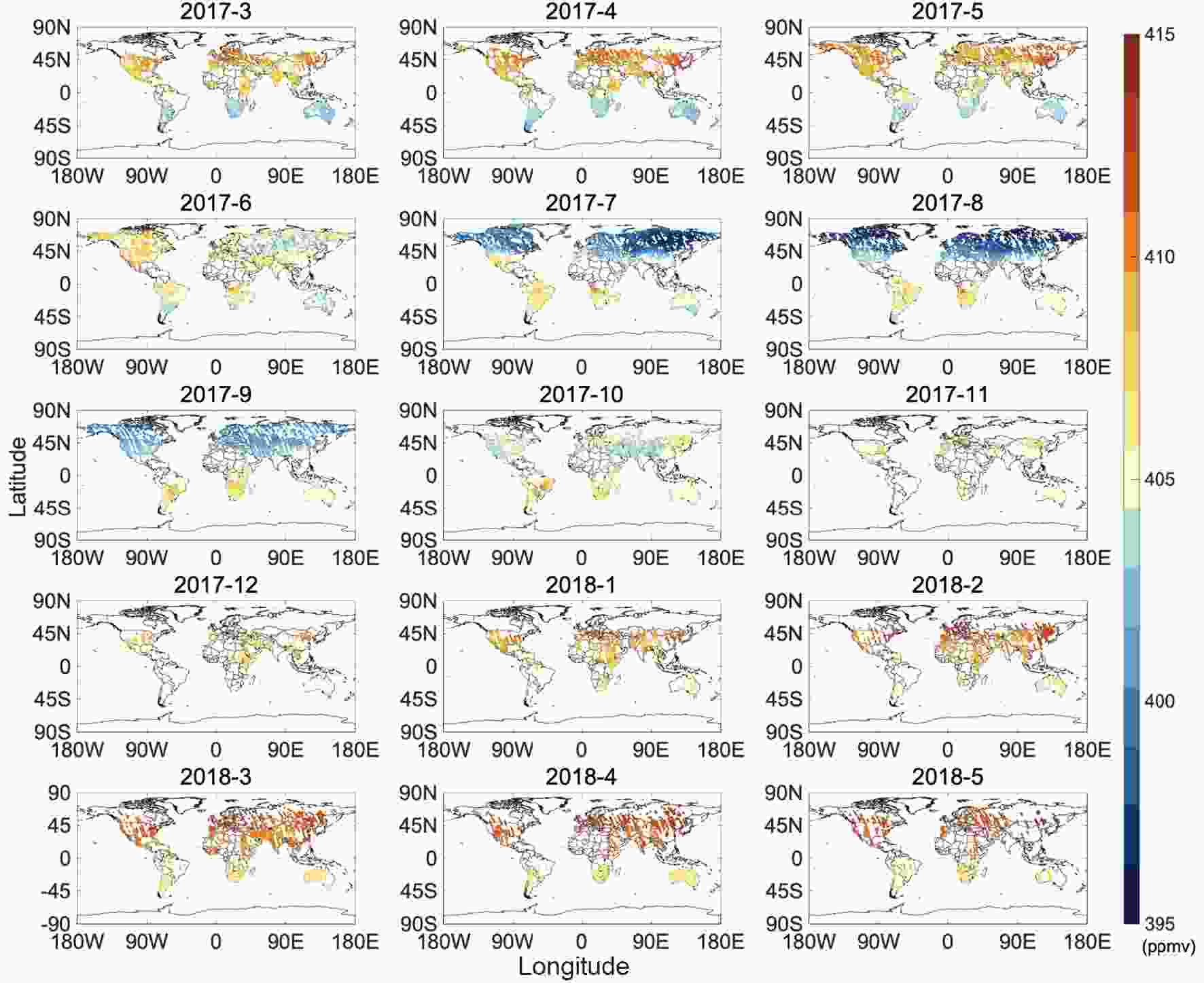
The new TanSat XCO2 data product is now retrieved by IAPCAS using the O2 A-band and CO2 weak band together. Fifteen months of the global XCO2 distribution (Fig. 1; land only) is shown for each month, indicating the CO2 seasonal variations in the Northern Hemisphere and the continually increasing CO2 values in the Southern Hemisphere. The anthropogenic impact is visible in winter and spring around China, Europe and the U.S. The TanSat v2 XCO2 data product can be obtained from the CASA TanSat data and science service (www.chinageoss.org/tansat). Information on measurement and retrieval quality, such as cloud clearing and post screening, is also provided in the data. Top-down carbon flux estimation research will be one of main objectives of the TanSat CO2 data, and hence we produce a special lite version with only core elements (e.g., XCO2, averaging kernel, and a priori CO2 profile) toward climate change studies.
 Figure1. Global TanSat v2 XCO2 distribution from March 2017 to May 2018 (land only). Colors indicate the values of XCO2 in ppmv.
In January 2020, a protocol was signed between the National Remote Sensing Center of the China Ministry of Science and Technology of China (MOST/NRSCC) and the ESA regarding the intended coordination of their activities in the Remote Sensing of Greenhouse Gases and Related Missions. MOST/NRSCC and ESA intend TanSat to be a third-party mission of ESA, and TanSat data have been included in key ESA programs such as the Climate Change Initiative plus (CCI+) (Buchwitz et al., 2015) and Earthnet Data Assessment Pilot (EDAP). The preliminary CCI+ TanSat XCO2 data product has been processed by the University of Leicester Full Physics Retrieval Algorithm (UoL-FP) (B?sch et al., 2006) for TCCON overpasses only, to evaluate the retrieval strategy and data quality, and is available to the public on the CCI+ data archive at http://cci.esa.int/data. Future plans will focus on the production of global TanSat retrievals, and those data will be part of the CCI+ data product.
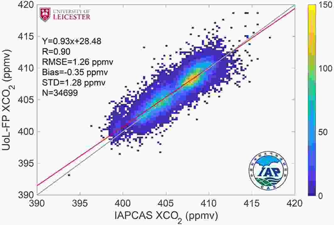
The IAPCAS and UoL-FP algorithms use a similar OEM (Optimal Estimation Method) technique but a different forward model, physical module and strategy (e.g., pre-screening, post-screening and state vectors) in their retrieval. The intercomparison of TanSat XCO2 retrieval between the two algorithms shows a good agreement for all TCCON overpass measurements with 34 699 individual measurements (Fig. 2). The dispersion between the two data products has a standard deviation of 1.28 ppmv, which mostly comes from noise error. There is a ?0.35 ppmv overall bias between both, and this systematic error is probably induced by the differences of the two algorithms and bias correction method.
 Figure2. Intercomparison of individual XCO2 retrievals between the IAPCAS TanSat v2 data product (horizontal axis) and the CCI+ TanSat product (vertical axis) for a total number of 34 699 individual data points. Color coding is the number density of the data. The solid gray line indicates the 1:1 line, and the red dashed line shows the linear regression results, with quantitative results given in the upper-left of the plot. RMSE and STD denote the root-mean-square error and standard deviation of the differences of the two data products.
Acknowledgements. This work was supported by the National Key R&D Program of China (Grant No. 2016YFA0600203), the Key Research Program of the Chinese Academy of Sciences (Grant No. ZDRW-ZS-2019-1), the International Partnership Program of the Chinese Academy of Sciences (Grant No. GJHZ201903), the National Natural Science Foundation of China (Grant No. 41905029), ESA Climate Change Initiative CCI+ (GhG theme), Earthnet Data Assessment Pilot (EDAP) project and ESA-MOST Dragon-4 programme (ID 32301). HB is supported by the UK NERC National Centre for Earth Observation (NCEO) (Grant Nos. nceo020005 and NE/N018079/1). The TanSat L1B data service is provided by IRCSD and CASA (131211KYSB20180002). We also thank the Fengyun Satellite Data Center of the National Satellite Meteorological Center, who provide the TanSat L1B data service. This research used the ALICE High Performance Computing Facility at the University of Leicester. The authors thank the TanSat mission, and the support from everyone involved with the TanSat mission is highly appreciated.
