 , 刘媛
, 刘媛兰州大学西部教育部重点实验室 兰州大学资源环境学院 兰州大学干旱区水循环与水资源研究中心,兰州 730000
The response of lake records to the circulation system and climate zones in China since the Last Glacial Maximum
LIYu, LIUYuan收稿日期:2016-05-17
修回日期:2016-07-23
网络出版日期:2016-11-25
版权声明:2016《地理学报》编辑部本文是开放获取期刊文献,在以下情况下可以自由使用:学术研究、学术交流、科研教学等,但不允许用于商业目的.
基金资助:
作者简介:
-->
展开
摘要
关键词:
Abstract
Keywords:
-->0
PDF (2992KB)元数据多维度评价相关文章收藏文章
本文引用格式导出EndNoteRisBibtex收藏本文-->
1 引言
湖泊是陆地水圈的重要组成部分,在一定的地质、地理背景下形成,其水位的变化蕴含着丰富的环境信息,是气候变化的良好指示器[1-3]。末次盛冰期以来中国气候变化存在一定的复杂性,不同区域湖泊水位变化过程也存在明显差异。为了探讨中国长时间尺度湖泊演化的规律和机制,前人做了大量的研究。2000年,于革等[4]提出末次盛冰期时期,中国西部地区高湖面与中东部地区的低湖面存在巨大反差,并通过国际古气候模型进行模拟,揭示西部地区高湖面主要是由于西风带位置的南移引起。薛滨等[5]分析了30 ka BP、18 ka BP和6 ka BP等3个特征时期有效降水与大气环流的总体格局,得出这3个特征时期湖泊水位的变化主要受控于大气环流的影响。Chen等[6]和Li等[7]分别选择了11个和8个湖泊来研究季风区和中亚干旱区内湖泊全新世演化历史,认为在季风区或中亚干旱区内的湖泊演化具有相似的历史。这些研究均说明长时间尺度湖泊演化受控于千年尺度大气环流特征的影响。由于中国地理地形复杂,下垫面类型丰富,影响气候的环流因素比较多,使得气候类型非常的复杂[8]。有研究表明[9-10],在不同的气候区内湖泊演化具有明显的分异性。本文基于柯本气候分类法,将中国气候划分为4个气候带、6个气候型和28种气候副型,根据NCEP/NCAR 0.5°×0.5° 1900-2015年的月降水数据集对中国传统季风—非季风区进行验证,同时在柯本气候分区和中国季风—非季风区的划分基础上,对中国34个具有可靠定年,湖泊水位变化记录从末次盛冰期到晚全新世具有一定连续性的湖泊运行CCSM 3.0气候模拟系统、能量平衡模型和水量平衡模型对其水位进行模拟,试图分析末次盛冰期以来中国湖泊水位演化及其潜在的驱动机制。
2 中国气候与环流
2.1 柯本分类法
柯本气候分类法由于其标准严格、界限明确、应用方便等特点,广泛的应用于全球,是世界上应用最广、影响最大的气候分类法之一[11-13]。它以气温、降水和季节变化作为分类依据,以月平均气温和降水作为分类指标,参考植被分布的规律以确定气候类型之间的界线指标值[14],将全球划分为5种基本气候带,12种主要气候类型(表1)。Tab. 1
表1
表1柯本气候符号及定义标准
Tab. 1Description of K?ppen climate symbols and definition criteria
| 气候带 | 气候型 | 气候副型 | 特征 |
|---|---|---|---|
| A热带 | Tcold ≥ 18β℃ | ||
| Af 热带雨林气候 | Pdry ≥ 60βmm | ||
| Aw 热带疏林草原气候 | Pdry ≤ 60βmm & Pdry ≥ (100-MAP/25) mm | ||
| Am 热带季风气候 | Pdry ≤ 60βmm & Pdry ≤ (100-MAP/25) mm | ||
| B干带 | MAP < 10βPth | ||
| Bs 草原气候 | MAP ≥ 5βPth | ||
| Bw 沙漠气候 | MAP < 5βPth | ||
| h | MAT ≥ 18β℃ | ||
| k | MAT < 18β℃ | ||
| C温暖带 | Thot >10β℃ & 0β℃< Tcold < 18β℃ | ||
| Cs 夏干温暖气候 | Psdry < 40βmm & Psdry <Pwwet/3 | ||
| Cw 冬干温暖气候 | Pwdry < Pswet/10 | ||
| Cf 常湿温暖气候 | 既非Cw也非Cf | ||
| a | Thot ≥ 22β℃ | ||
| b | Thot < 22β℃ & count (Tmon > 10β℃) ≥ 4 | ||
| c | Tcold ≥-38β℃ & count(Tmon > 10β℃) < 4 | ||
| D冷温带 | Thot >10β℃ & Tcold ≤ 0β℃ | ||
| Df 常湿冷温气候 | Pwdry ≥ Pswet/10 | ||
| Dw 冬干冷温气候 | Pwdry < Pswet/10 | ||
| a | Thot ≥ 22β℃ | ||
| b | Thot < 22β℃ & count (Tmon > 10β℃) ≥ 4 | ||
| c | Tcold ≥-38β℃ & count (Tmon > 10β℃) < 4 | ||
| d | Tcold < -38β℃ | ||
| E极地带 | Thot < 10β℃ | ||
| ET 苔原气候 | Thot ≥ 0β℃ | ||
| EF 冰原气候 | Thot < 0β℃ | ||
| G | H ≥ 2500βm |
新窗口打开
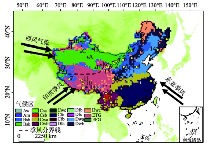
本文使用地面降水月值0.5°×0.5°格点数据集、中国地面气温月值0.5°×0.5°格点数据集,中国高程0.5°×0.5°格点数据,基于柯本气候分类法将中国气候划分为4个气候带、6个气候型和28种气候副型,中国大陆几乎没有热带气候分布,仅有很少的热带疏林草原气候和热带季风气候分布在海南南部;气候带有干带(B)、温暖带(C)、冷温带(D)和以高地气候为主的极地带(E),主要气候型有草原气候(Bs)、沙漠气候(Bw)、冬干温暖气候(Cw)、常湿温暖气候(Cf)、冬干冷温气候(Dw)、苔原气候(ET)(图1)。
 显示原图|下载原图ZIP|生成PPT
图1中国气候系统图示和各气候区所选湖泊分布
注:中国的气候系统包括西风气流、印度季风以及东亚季风,A~L共12个湖泊位于中亚干旱区,1~22共22个湖泊位于亚洲季风区,虚线代表亚洲季风在中国的边界。
-->Fig. 1Map showing the dominant circulation systems and the lake sites selected in this study for different climate zones
-->
2.2 季风区的划分
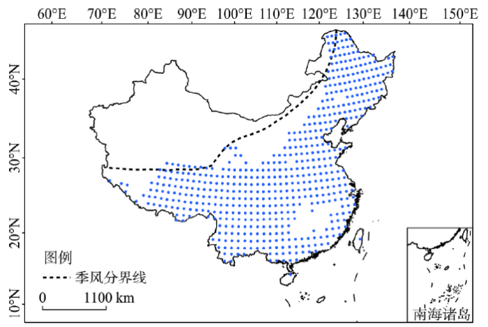
由于年际太阳辐射的变化,季风会随着时间的变化在全球范围内发生变化[15],因此季风区的定义非常的复杂。2006年,Wang等[16]认为年夏季降水量与冬季降水量的差值大于180 mm,同时夏季降水量超过年降水量35%的地区是季风区;Wang等[17]在2008年时将季风区定义为,年夏季降水量与冬季降水量差值大于300 mm,同时季风降水指数超过0.5的区域;Liu等[18]和Wang等[19]认为夏季与冬季降水之差超过2 mm/天,并且夏季降水超过年降水量55%的地区是季风区,其中夏季指每年的5-9月,冬季指每年的11-3月;Chen等[6]和Li等[7]依据水汽输送场对季风区进行划分。本文利用NCEP/NCAR 0.5°×0.5° 1900-2015年的月降水数据集,参考Liu等[18]和Wang等[19]季风区定义对中国的季风区进行模拟,同时对Chen等[6]和Li等[7]按水汽输送划分的主要受夏季季风环流影响的季风区和受西风控制的中亚干旱区进行验证(图2),可以看出两种方法所划分的季风区具有明显的相似性,但由于水汽输送场综合考虑水汽、风场和高度场等资料[20],因此两种定义方法存在一些误差。本文引用Chen等[6]和Li等[7]季风区定义方法做后续研究。
 显示原图|下载原图ZIP|生成PPT
图2根据1900-2015年降水月值数据集所模拟中国季风分布
注:蓝色点代表据1900-2015年降水月值数据集所模拟的中国季风区域,虚线是按水汽输送定义的亚洲季风在中国的边界。
-->Fig. 2Monsoon area obtained from monthly precipitationdataset for the period 1900-2015
-->
3 方法
3.1 中国湖泊记录
湖泊的形成没有明显的规律性,可以分布在任何海拔高度,从5000 m以上(青藏高原湖泊)到海平面以下155 m(艾丁湖),也可以分布在任何一个气候区内[21]。根据柯本气候分类法划分结果,在每个气候区内选择具有代表的典型湖泊(图1,表2),其中A~L共12个湖泊位于中亚干旱区,其余湖泊位于亚洲季风区。这些湖泊都具有可靠的定年,湖泊水位变化的记录从末次盛冰期到晚全新世具有一定的连续性,运用了孢粉、硅藻、沉积物岩性、湖泊岸堤定年和地球化学指标等指标,有效的显示湖泊水位变化。Tab. 2
表2
表2中国所选择的34个湖泊末次盛冰期以来湖泊资料
Tab. 2The data of selected lakes in China since the Last Glacial Maximum
| 序号 | 湖泊名 | 纬度 | 经度 | 21-8.5 ka | 21-6 ka | 21 ka-PI | 8.5-6 ka | 8.5 ka-PI | 6 ka-PI | 气候带 | 气候型 | 气候副型 | 环流气候区 | 参考文献 |
|---|---|---|---|---|---|---|---|---|---|---|---|---|---|---|
| A | 罗布泊 | 40.29 | 90.8 | 高 | 高 | 高 | 低 | 低 | 高 | 干带 | 沙漠气候 | k | 中亚干旱区 | Chao等[22]; Yan等[23] |
| B | 艾比湖 | 44.9 | 82.7 | 高 | 高 | 高 | 低 | 高 | 高 | 干带 | 沙漠气候 | k | 中亚干旱区 | Wu等[24]; 靳等[25] |
| C | 博斯腾湖 | 42 | 87 | 低 | 低 | 低 | 低 | 低 | 高 | 干带 | 沙漠气候 | k | 中亚干旱区 | Wu¨nnemann等[26]; Huang等[27] |
| D | 班公错 | 33.7 | 79.42 | 高 | 不变 | 高 | 低 | 高 | 高 | 干带 | 沙漠气候 | k | 中亚干旱区 | Fontes等[28]; 李元芳等[29] |
| E | 青海达布逊湖 | 36.97 | 95.11 | 低 | 低 | 低 | 低 | 高 | 高 | 干带 | 沙漠气候 | k | 中亚干旱区 | 江德昕等[30] |
| F | 玛纳斯湖 | 45.75 | 86 | 低 | 低 | 低 | 高 | 不变 | 低 | 干带 | 沙漠气候 | k | 中亚干旱区 | Rhodes等[34] |
| G | 乌伦古湖 | 47.2 | 87.29 | 低 | 低 | 低 | 低 | 低 | 高 | 干带 | 草原气候 | k | 中亚干旱区 | Mischke等[32]; 安成邦等[33] |
| H | 巴里坤湖 | 43.66 | 92.8 | 高 | 高 | 高 | 低 | 低 | 高 | 干带 | 草原气候 | k | 中亚干旱区 | Ma等[35]; Lu等[36] |
| I | 台错 | 33.72 | 80.7 | 低 | 高 | 高 | 高 | 高 | 高 | 干带 | 草原气候 | k | 中亚干旱区 | Zheng等[37] |
| J | 呼伦湖 | 48.9 | 117.4 | 低 | 低 | 低 | 高 | 高 | 低 | 干带 | 草原气候 | k | 中亚干旱区 | 王苏民等[38]; Zhai[39] |
| K | 哈拉湖 | 38.28 | 97.58 | 低 | 低 | 低 | 低 | 低 | 低 | 极地带 | 苔原气候 | G | 中亚干旱区 | Yan等[40] |
| L | 赛里木湖 | 44.5 | 81.2 | 低 | 低 | 低 | 低 | 高 | 高 | 冷温带 | 冬干冷温气候 | c | 中亚干旱区 | Jiang等[41]; 陈明勇等[42] |
| 1 | 查干淖尔湖 | 43.27 | 112.9 | 高 | 高 | 高 | 不变 | 高 | 高 | 干带 | 沙漠气候 | k | 季风区 | 江德昕等[43] |
| 2 | 猪野泽 | 39.05 | 103.85 | 低 | 高 | 高 | 高 | 高 | 不变 | 干带 | 沙漠气候 | k | 季风区 | Zhang等[44]; Pachur等[45] |
| 3 | 吉兰泰盐湖 | 39.7 | 105.09 | 低 | 低 | 低 | 高 | 高 | 低 | 干带 | 沙漠气候 | k | 季风区 | Jia等[46]]; Geng等[47] |
| 4 | 宁晋泊 | 37.25 | 114.75 | 低 | 低 | 高 | 低 | 高 | 高 | 干带 | 草原气候 | k | 季风区 | Zhang等[48] |
| 5 | 萨拉乌苏古湖 | 37.7 | 108.6 | 低 | 低 | 高 | 不变 | 高 | 高 | 干带 | 草原气候 | k | 季风区 | Zhang等 [49] |
| 6 | 盐海子湖 | 40.2 | 108.4 | 高 | 高 | 高 | 高 | 高 | 不变 | 干带 | 草原气候 | k | 季风区 | Chen等[50]; 钱作华等[51] |
| 7 | 扎布耶盐湖 | 31.35 | 84.07 | 高 | 高 | 高 | 低 | 高 | 高 | 干带 | 草原气候 | k | 季风区 | Wang等[52]; 刘俊英等[53] |
| 8 | 沉错 | 28.93 | 90.6 | 高 | 高 | 不变 | 高 | 高 | 高 | 极地带 | 苔原气候 | G | 季风区 | Zhu等[54] |
| 9 | 乱海子湖 | 37.58 | 101.33 | 低 | 低 | 低 | 高 | 高 | 高 | 极地带 | 苔原气候 | G | 季风区 | Herzschuh等[55] |
| 10 | 班戈错 | 31.75 | 89.57 | 不变 | 高 | 高 | 高 | 高 | 不变 | 极地带 | 苔原气候 | G | 季风区 | 赵希涛等[56] |
| 11 | 纳木错 | 30.65 | 90.5 | 低 | 低 | 低 | 低 | 高 | 高 | 极地带 | 苔原气候 | G | 季风区 | Mügle等 [57]; Witt等[58] |
| 12 | 岱海 | 40.58 | 112.7 | 低 | 低 | 低 | 低 | 高 | 高 | 冷温带 | 冬干冷温气候 | b | 季风区 | 王苏民等[59]; Wang等[60] |
| 13 | 兴凯湖 | 45.2 | 132.2 | 低 | 低 | 不变 | 低 | 高 | 高 | 冷温带 | 冬干冷温气候 | b | 季风区 | 吴健等[61] |
| 14 | 二龙湾玛珥湖 | 42.3 | 126.37 | 低 | 低 | 低 | 低 | 高 | 高 | 冷温带 | 冬干冷温气候 | b | 季风区 | 刘玉英等[62] |
| 15 | 青海湖 | 37.5 | 100.5 | 低 | 低 | 低 | 高 | 高 | 不变 | 冷温带 | 冬干冷温气候 | c | 季风区 | Madsen等[63]; Colman等[64]; |
| 16 | 若尔盖湖 | 33.13 | 103.65 | 低 | 低 | 低 | 不变 | 高 | 高 | 冷温带 | 冬干冷温气候 | c | 季风区 | Zhou等[65]; 唐领余等[66] |
| 17 | 大湖 | 24.25 | 115.033 | 低 | 低 | 高 | 不变 | 高 | 高 | 温暖带 | 常湿温暖气候 | a | 季风区 | Xiao等[67] |
| 18 | 太湖 | 31.5 | 120.5 | 低 | 低 | 高 | 不变 | 高 | 高 | 温暖带 | 常湿温暖气候 | a | 季风区 | 薛滨等[68]; 王建等[69] |
| 19 | 洱海 | 25.84 | 99.98 | 高 | 高 | 高 | 不变 | 高 | 高 | 温暖带 | 夏干温暖气候 | b | 季风区 | Madsen等[70] |
| 20 | 湖光岩玛尔湖 | 21.15 | 110.28 | 低 | 低 | 低 | 高 | 高 | 高 | 温暖带 | 冬干温暖气候 | a | 季风区 | Mingram等[71] |
| 21 | 星云湖 | 24.5 | 102.88 | 低 | 低 | 低 | 不变 | 高 | 高 | 温暖带 | 冬干温暖气候 | b | 季风区 | Hodell等[72] |
| 22 | 泸沽湖 | 27.72 | 100.79 | 低 | 低 | 高 | 低 | 高 | 高 | 温暖带 | 冬干温暖气候 | b | 季风区 | Wang等[73]; Xiao等[74] |
新窗口打开
3.2 CCSM气候模拟系统
通用气候系统模式(Community Climate System Model, CCSM 3.0)是美国NSF、能源部、NASA、NCAR和NOAA共同开发的完全耦合的全球气候模式。CCSM 3.0有别于传统的大气环流模式(General Circulation Models, GCMs),是一个大气、海洋、陆地和海冰完全耦合模式,并且可以在3种不同的模式分辨率下运行,得到了非常广泛的应 用[75],本文根据气候系统模式模拟了中国末次盛冰期以来的气候变化。系统中,海洋和海冰模型水平分辨率为1°,大洋系统40个垂直分层,大气和陆地板块部分的水平分辨率为2.8°,大气环流模型板块垂直26层,陆地模型板块土壤分为10层。本文选取模拟的时间段分别为21 ka BP、8.5 ka BP、6 ka BP和PI(Pre-Industrial, 1800AD)。21 ka BP(末次盛冰期)是2万年来距人类环境最近、与现代反差最大的气候时期;8.5 ka BP是早全新世的代表时段,处于“8.2 ka BP全球性冷事件”之前,不受这一全球性冷事件的影响;6.0 ka BP是中全新世的代表时段;PI处于工业革命之前,受人类活动影响较弱。表3中列出4个时间段的边界条件,包括轨道参数[15]、大气中微量气体含量[76-78]、大陆冰盖[79]以及植被组成。
Tab. 3
表3
表321 ka BP、8.5 ka BP、6.0 ka BP和PI 4个时段的模拟边界值
Tab. 3Boundary conditions used for CCSM 3 model experiments at 21 ka BP, 8.5 ka BP, 6 ka BP and PI
| Pre-Industrial | 6 ka | 8.5 ka | 21 ka | |
|---|---|---|---|---|
| 离心率 | 0.016724 | 0.018682 | 0.019199 | 0.018994 |
| 倾角(°) | 23.45 | 24.1 | 24.22 | 22.949 |
| 近日点经度(°) | 102.04 | 0.87 | 319.5 | 114.42 |
| CO2 (ppm) | 280 | 280 | 260 | 185 |
| CH4 (ppb) | 760 | 650 | 660 | 350 |
| N2O (ppb) | 270 | 270 | 260 | 200 |
| 大陆冰川 | Peltier (2004) 0 ka | Peltier (2004) 0 ka | Peltier (2004) 8.5 ka | Peltier (2004) 21 ka |
| 植被组成 | 同现代 | 同现代 | 同现代 | 同现代 |
新窗口打开
3.3 湖泊能量平衡模型
本文运用Hostetler等[80]研究的湖泊能量平衡模型,对全国的湖泊进行能量平衡计算。在这个平衡模型中,湖泊表层的能量平衡由湖泊表层的蒸发量控制,普遍假设湖泊深度为1 m,湖泊水垂直方面之间并不混合。如下:式中:cw为水比热(J kg-1 K-1);ρw为水体密度(kg m-3);z为湖泊深度(m);T为湖泊表层温度(K);t为时间(s);φs、φld分别为被水体吸收的短波和长波辐射;φlu为湖泊发出的长波的长波辐射;Qe为潜在热通量;Qh为感热通量。
3.4 湖泊水量平衡模型
本文假设CCSM 3.0系统中,全国每一个陆面的网格单元为一个单独的湖泊,每个湖泊处于水文平衡态,同时也不存在气候变化过程不稳定的情况。因此稳定条件下的湖泊水量平衡公式如下:式中:V为湖泊水量的变化(m3/year);AB、AL分别为流域面积(m2)、湖泊面积(m2);R为流域径流量(m/year);PL为降水量(m/year);EL为湖泊表面蒸发量(m/year)。由于方程(2)对于假想的湖泊需要AB、AL确定的数值,因此不能很好的计算湖泊水量变化过程。这是由于PL-EL ≥ 0网格单元代表的湖泊是开放的湖泊,无论湖泊水量是如何变化,开放的湖泊都会通过湖水的排放来调节水量平衡,而PL-EL < 0的网格单元代表的湖泊水净损失需要径流来弥补。因此,将方程(2)进行简化如下:
根据方程(2)、(3)可以模拟末次盛冰期以来每个单独网络的湖泊水位变化情况。
4 湖泊演化规律及驱动机制的探讨
4.1 湖泊水量能量平衡模拟结果与湖泊记录对比
根据水量能量平衡模型模拟中国湖泊自末次盛冰期以来21 ka BP、8.5 ka BP、6.0 ka BP和PI 4个时段湖泊水位高低的变化以及引起湖泊水位变化的原因(图3)。末次盛冰期时期中国大部分地区湖泊水位与全新世相比处于低水位状态,而高水位主要位于中国西北内陆干旱区西部地区。全新世湖泊水位模拟结果显示季风区湖泊水位在早全新世(8.5 ka BP)时期达到峰值(图3d、3e、3f),中全新世(6.0 ka)水位次之,PI期间水位最低。这与季风区所选择的23个湖泊全新世演化资料显示的演化记录具有很好的一致性。在中亚干旱区,PI期间湖泊水位高于8.5 ka BP和6.0 ka BP,中全新世6.0 ka BP的湖泊水位高于早全新世8.5 ka BP。该区域的湖泊演化资料显示,早全新世湖泊水位较低,中全新世期间湖泊水位达到峰值,这与模拟结果非常匹配,但是湖泊演化记录显示,晚全新世期间湖泊水位出现下降的趋势,这与模拟结果不同,模拟结果显示晚全新世期间中亚干旱区湖泊水位持续上升。虽然大部分的湖泊在晚全新世期间显示湖泊水位比较低,但是个别的湖泊显示高湖面[31, 38-39, 41-42],这一差异可能是由于人类活动以及模型误差引起的。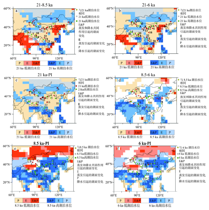 显示原图|下载原图ZIP|生成PPT
图3根据水量能量平衡模型模拟的中国自末次盛冰期以来湖泊水位高低的变化及其原因
注:浅蓝色、蓝色和深蓝色分别表示由降水增加,湖泊表面蒸发量降低以及降水和表面蒸发共同引起的湖泊水位上升;粉色、橘色和深橘色分别表示由降水减少,湖泊表面蒸发量增加,降水和表面蒸发共同引起的湖泊水位下降;白色表示没有水位变化。
-->Fig. 3The results and reasons of lake-level changes based on the lake energy& water balance model and CCSM 3 since the Last Glacial Maximum
-->
4.2 中国末次盛冰期以来湖泊水位变化及可能性因素
根据古湖泊记录,末次盛冰期以来湖泊水位的变化规律可以分为4类(图4):① 中、晚全新世期间湖泊水位相对较高;② 末次盛冰期和中全新世湖泊水位均较高;③ 早、中全新世湖泊水位相对较高;④ 末次盛冰期和早全新世湖泊水位均较高。从图4可以看出,末次盛冰期以来中国湖泊水位的变化在各柯本气候区内没有明显的规律,而在季风区和西风带控制的中亚干旱区具有明显的空间分异性,说明中国长时间尺度的湖泊演化受控于千年尺度大气环流特征的影响。末次盛冰期以来,季风区中国湖泊演化规律主要有2种,早中全新世湖泊水位相对较高以及末次盛冰期和早全新世湖泊水位均较高,而在西风带控制的中亚干旱区湖泊演化规律主要有以下2种,中晚全新世期间湖泊水位相对较高以及末次盛冰期和中全新世湖泊水位均较高。其中青海达布逊湖、哈拉湖、台错和扎布耶盐湖这4个湖泊位于中亚西风带控制区与亚洲季风区的交汇过渡地带,气候受亚洲季风系统与西风带气流的共同影响[81],其气候演变可能并非遵循某一单一模式,而主要取决于两大气候系统在该区的相对强弱对比[82],因此末次盛冰期以来该区域湖泊演化和气候变化比较复杂,其中青海达布逊湖、哈拉湖、台错这3个湖泊显现出季风区湖泊演化特点,而扎布耶盐湖显现出中亚干旱区湖泊演化的特征。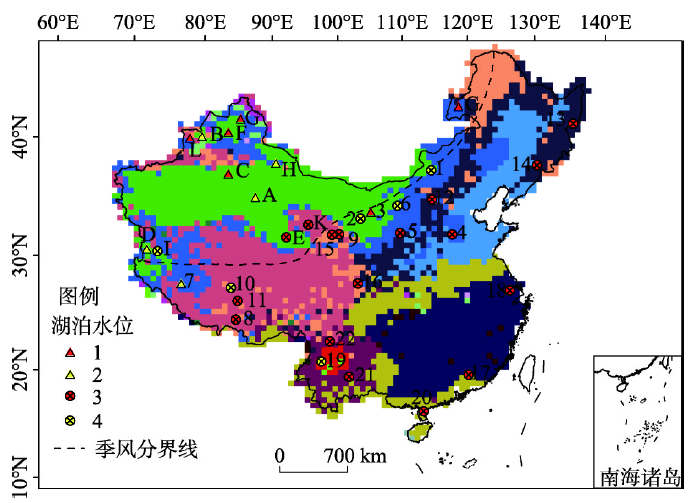 显示原图|下载原图ZIP|生成PPT
图4末次盛冰期以来中国湖泊演化类型
注:各数字代表湖泊演化类型:1.中晚全新世期间湖泊水位相对较高;2.末次盛冰期和中全新世湖泊水位均较高;3.早中全新世湖泊水位相对较高;4.末次盛冰期和早全新世湖泊水位均较高。
-->Fig. 4Types of lake evolution in China since the Last Glacial Maximum
-->
在季风区,从图3a、3b和3c可以看出末次盛冰期相对于全新世而言,低湖泊水位主要是由于降水量较少引起的,而高湖泊水位主要是由于降水和湖泊表面蒸发量共同作用引起的。Li等[83]利用4个气候模拟系统对季风区和中亚干旱区末次盛冰期和晚全新世(PI)期间的湖泊水位变化进行模拟,认为末次盛冰期低湖泊水位主要由于降水量较少引起。Qin等[84]认为冰期气候比较寒冷使得蒸发量显著减少,季风区的湖泊在降水减少的情况下显现出湖泊水位升高的特点。从图3d、3e和3f可以看出高降水和低湖泊表面蒸发量共同作用导致早中全新世湖泊水位比较高。这是由于北半球夏季太阳辐射增强,增加的太阳辐射加剧了海陆温差,使吹向陆地的偏南气流得以加强,带来了大量的降水,使得季风区早中全新世的湖面水位升高,中全新世以后夏季太阳辐射开始减弱,季风开始萎缩,湖泊水位开始下降[7, 85-86]。
在中亚干旱区,从水量平衡模拟结果(图3a、3b、3c)可看出,末次盛冰期湖泊低湖面主要是由于低降水量引起的,而高湖泊水面主要是由于低蒸发量引起的。于革等[4]利用气候模式对末次盛冰期风场、降水和有效降水进行模拟,认为末次盛冰期时期北半球高纬度地区亚洲大陆西侧大陆冰流比较强盛,迫使西风带向南迁移,海陆温差缩小,东亚夏季风萎缩, 可能诱使西风带全年强盛,同时冰期中的低温引起了蒸发量降低,可能导致湖水损失比较少,形成末次盛冰期的高湖面。中全新世湖泊水位高于末次盛冰期的湖泊水位,主要是由于末次盛冰期降雨量较少(图3d、3e、3f)。中亚干旱区的水汽输送主要来自西风带,该地区西风带的水汽源是大西洋、北冰洋、地中海以及黑海[87],该地区的冬季降水占全年降水的比例非常大。从全球范围来看,虽然北半球总太阳辐射量从早全新世到PI期间一直在减少,但是冬季太阳辐射量却从早全新世到PI期间一直增加[15],使得该地区的降雨量从早全新世到晚全新世一直增加。从图3d可以看出,在中亚干旱区,早全新世期间的低湖泊水位主要是由于降水量较少引起的,而中全新世的高湖面主要是由于降水的增加以及早全新世到晚全新世期间北半球冬季太阳辐射减少。
5 结论
本文基于柯本分类法将中国划分为4个气候带、6个气候型和28种气候副型,在每个气候型中选择具有清晰水位变化资料的湖泊,分析湖泊在21 ka BP、8.5 ka BP、6 ka BP和PI 4个特征时期演化过程。同时应用CCSM 3.0气候模拟模式、能量和水量平衡模型模拟末次盛冰期以来中国湖泊水位变化情况及其驱动机制。结果表明,末次盛冰期以来中国湖泊演变主要受千年尺度大气环流的驱动影响,在各个柯本气候区内没有明显的规律性。末次盛冰期以来,在季风主导的季风区中国湖泊演化主要有2种类型,包括早中全新世湖泊水位相对较高以及末次盛冰期和早全新世湖泊水位均较高;在西风带控制的中亚干旱区湖泊演化也有2种类型,包括中晚全新世期间湖泊水位相对较高以及末次盛冰期和中全新世湖泊水位均较高。The authors have declared that no competing interests exist.
参考文献 原文顺序
文献年度倒序
文中引用次数倒序
被引期刊影响因子
| [1] | . Spatial and temporal patterns in lake-level data from 38 sites in Australia and Papua New Guinea provide a basis for reconstructing changes in water balance and atmospheric circulation during the past 30,000 years. The reconstructions are consistent with hydrological changes inferred from pollen analysis and palaeowind directions inferred from dunes. Generally wetter conditions between 30,000 and 24,000 BP are consistent with a strong Walker Circulation with the STA near its present position. General aridity at the glacial maximum until 12,000 BP with higher than present lake levels in the southeastern interior of Australia, implies that the southern margin of the subtropical anticyclone belt was expanded southward and the southern Westerlies were correspondingly displaced. This southward shift appears in all GCM simulations of the 18,000 BP climate and may be a result of the increased vigour of the northern hemisphere circulation. A northward migration of the belt of high lake levels between 11,000 and 6000 BP suggests that the STA shifted back equatorward to north of its present position. Relaxation to modern conditions occurred after 6000 BP interrupted by an unexplained dry phase (6000-5000 BP) in Tasmania and Queensland. |
| [2] | late Pleistocene; lake level; Tengger Desert; NW China; C-14 data |
| [3] | . 天山北坡乌鲁木齐河1号冰川与土尤克苏冰川物质平衡观察表示80年代比以前出现大的亏损。青海湖与伊赛克湖在近百年一直处于萎缩状态。从小冰期最盛时以来,乌鲁木齐河谷中冰川面积已缩去44%。上述及其他冰川与湖泊变化证据清楚地指示本世纪气候干暖化趋势增强了,并可能延续到下世纪初。但如由于CO_2及其他痕量气体增加所致的温室效应使下世纪重现全新世早、中期那样的高温,则亚洲中部有可能转为潮湿。 . 天山北坡乌鲁木齐河1号冰川与土尤克苏冰川物质平衡观察表示80年代比以前出现大的亏损。青海湖与伊赛克湖在近百年一直处于萎缩状态。从小冰期最盛时以来,乌鲁木齐河谷中冰川面积已缩去44%。上述及其他冰川与湖泊变化证据清楚地指示本世纪气候干暖化趋势增强了,并可能延续到下世纪初。但如由于CO_2及其他痕量气体增加所致的温室效应使下世纪重现全新世早、中期那样的高温,则亚洲中部有可能转为潮湿。 |
| [4] | . <p>根据中国古湖泊数据库提供的湖泊水量空间信息和系统分析, 发现我国西部地区在末次盛冰期(LGM)时期存在着湖面比现代高面积比现代大水质体比现代淡化的湖泊. 这与中国中东部的低湖面或干枯湖盆有着巨大的反差. 这些高湖面与中亚和地中海地区的高湖面连成一带, 但南与印度中南部的低湖面北与中西伯利亚若干个低湖面皆形成反差. 根据国际古气候模型对 LGM 时期模拟, 我国西部地区有效降水有所增加, 变化幅度70 95 mm/a. 模型揭示了西风带不仅位置向南移动, 其强度也有所增强, 影响范围东扩. 同时表明欧亚大陆降温幅度在4 16°C, 地表蒸发能力极弱, 有利于在我国西部形成相对冷湿气候.</p> . <p>根据中国古湖泊数据库提供的湖泊水量空间信息和系统分析, 发现我国西部地区在末次盛冰期(LGM)时期存在着湖面比现代高面积比现代大水质体比现代淡化的湖泊. 这与中国中东部的低湖面或干枯湖盆有着巨大的反差. 这些高湖面与中亚和地中海地区的高湖面连成一带, 但南与印度中南部的低湖面北与中西伯利亚若干个低湖面皆形成反差. 根据国际古气候模型对 LGM 时期模拟, 我国西部地区有效降水有所增加, 变化幅度70 95 mm/a. 模型揭示了西风带不仅位置向南移动, 其强度也有所增强, 影响范围东扩. 同时表明欧亚大陆降温幅度在4 16°C, 地表蒸发能力极弱, 有利于在我国西部形成相对冷湿气候.</p> |
| [5] | . 正 单个湖泊的水位波动是流域范围内水量平衡的综合体现,而区域一致的湖泊水位波动可以指示区域降水和有效降水的变化,并进而反映水汽输送与大气环流的空间格 局,综合大范围湖泊水位波动数据,建立相应的古湖泊水位数据库,来定性恢复区域乃至全球的古气候状况,这已成为第四纪科学研究领域最有成效的途径之一。 . 正 单个湖泊的水位波动是流域范围内水量平衡的综合体现,而区域一致的湖泊水位波动可以指示区域降水和有效降水的变化,并进而反映水汽输送与大气环流的空间格 局,综合大范围湖泊水位波动数据,建立相应的古湖泊水位数据库,来定性恢复区域乃至全球的古气候状况,这已成为第四纪科学研究领域最有成效的途径之一。 |
| [6] | . We synthesize palaeoclimate records from the mid-latitude arid Asian region dominated today by the Westerlies (“arid central Asia” (ACA)) to evaluate spatial and temporal patterns of moisture changes during the Holocene. Sediment records from 11 lakes with reliable chronologies and robust proxies were selected to reconstruct moisture histories based on a five-class ordinal wetness index with assigned scores from the driest to wettest periods at individual sites for 200-year time slices. The proxies used in these records include pollen and diatom assemblages, sediment lithology, lake levels, and geochemistry (mainly isotope) data. The results of our synthesis show that ACA as a whole experienced synchronous and coherent moisture changes during the Holocene, namely a dry early Holocene, a wetter (less dry) early to mid-Holocene, and a moderately wet late Holocene. During the early Holocene most of the lakes experienced very low water levels and even dried out before ca 802ka (102ka=100002cal02a02BP). Hence the effective-moisture history in ACA is out-of-phase with that in monsoonal Asia as documented by numerous palaeoclimate records. In monsoonal Asia, a strong summer monsoon and humid climate characterized the early Holocene, and a weakened summer monsoon and drier climate prevailed during the late Holocene, which were mainly controlled by changes in low-latitude summer insolation. In contrast, we propose that the pattern of Holocene effective-moisture evolution in the westerly dominated ACA was mainly determined by North Atlantic sea-surface temperatures (SSTs) and high-latitude air temperatures that affect the availability, amount and transport of water vapor. Also, topography of the Tibetan Plateau and adjacent Asian highlands could have contributed to the intensification of dry climate in ACA during the early Holocene, as a result of strengthening the subsidence of dry air masses, associated with stronger uplift motion on the plateau by intense heating under a stronger summer insolation. Summer insolation might have played a key role in directly controlling moisture conditions in ACA but only after the northern hemisphere ice-sheets had disappeared in the mid- and late Holocene. |
| [7] | . Lake-level records provide a rich resource of information about past changes in effective moisture, but water-balance fluctuations can be driven by a number of different climate variables and it is often difficult to pinpoint their exact cause. This understanding is essential, however, for reconciling divergent paleo-records or for making predictions about future lake-level variations. This research uses a series of models, the NCAR CCSM3, a lake energy-balance and a lake water-balance model, to examine the reasons for lake-level changes in monsoonal Asia and arid central Asia between the early (8.5 ka), middle (6.0 ka) and late (ca. 1800 AD) Holocene. Our results indicate that the components of the lake water balance responsible for lake-level changes varied by region and through time. High lake levels at 8.5 and 6.0 ka in the monsoon region were caused by the combined effects of low lake evaporation and high precipitation. The low lake evaporation resulted from low winter solar radiation and high summer cloud cover. Precipitation associated with the mid-latitude westerlies increased from the early to middle Holocene and maintained high lake levels throughout most of arid central Asia ca. 6 ka. The modeled evolution of lake level in arid central Asia from the mid to late Holocene was spatially heterogeneous, due to different sensitivities of the northern and southern parts of the region to seasonally-changing insolation, particularly regarding the duration of lake ice cover. The model results do not suggest that precipitation and lake evaporation changes compete with one another in forcing lake-level change, as has been hypothesized. |
| [8] | . <p>根据全国609个气象站1971-2000年的日气象观测资料,遵循地带性与非地带性相结合、发生同一性与区域气候特征相对一致性相结合、综合性和主导因素相结合、自下而上和自上而下相结合、空间分布连续性与取大去小等5个基本原则,在充分吸纳已有气候区划基本理论与区划方法的基础上,参照中国科学院《中国自然地理》编辑委员会制定的气候区划三级指标体系,对我国气候进行重新区划;结果将我国划分为12个温度带、24个干湿区、56个气候区。与先前区划方案相比发现:20世纪70年代以来,中国气候带、区的总体格局并未发生明显变化,但一些重要的气候分界线却出现了一定程度的移动。其中亚热带北界与暖温带北界均出现了北移,北方地区的半湿润与半干旱分界线也出现了不同程度的东移与南扩,同时中温带、暖温带、北亚热带和中亚热带的三级气候区也出现了一定程度的变动;这种变化可能主要是因为20世纪80年代以后我国大多数地区出现不同程度的增暖及北方一些区域出现干旱化而引起的;且与本区划所采用的资料站点和部分区划原则有一定更新有关。</p> . <p>根据全国609个气象站1971-2000年的日气象观测资料,遵循地带性与非地带性相结合、发生同一性与区域气候特征相对一致性相结合、综合性和主导因素相结合、自下而上和自上而下相结合、空间分布连续性与取大去小等5个基本原则,在充分吸纳已有气候区划基本理论与区划方法的基础上,参照中国科学院《中国自然地理》编辑委员会制定的气候区划三级指标体系,对我国气候进行重新区划;结果将我国划分为12个温度带、24个干湿区、56个气候区。与先前区划方案相比发现:20世纪70年代以来,中国气候带、区的总体格局并未发生明显变化,但一些重要的气候分界线却出现了一定程度的移动。其中亚热带北界与暖温带北界均出现了北移,北方地区的半湿润与半干旱分界线也出现了不同程度的东移与南扩,同时中温带、暖温带、北亚热带和中亚热带的三级气候区也出现了一定程度的变动;这种变化可能主要是因为20世纪80年代以后我国大多数地区出现不同程度的增暖及北方一些区域出现干旱化而引起的;且与本区划所采用的资料站点和部分区划原则有一定更新有关。</p> |
| [9] | . <p>系统地归纳了湖泊环境演变研究的沉积指标体系, 并对其进行适当分类. 综述了末次盛冰期以来我国青藏高原、西北干旱区、云贵高原以及东部平原地区湖泊时空演变的过程与特征, 并从不同时间尺度探讨湖泊环境演变的驱动机制. 提出未来该领域亟待深入开展的工作, 包括加强湖泊环境指标的基础理论研究和科学涵义认识, 拓展高分辨率湖泊环境演变时间序列和空间分异规律的研究, 关注人类活动对湖泊环境的影响, 以及进一步加强中国第四纪湖泊数据库建设等.</p> . <p>系统地归纳了湖泊环境演变研究的沉积指标体系, 并对其进行适当分类. 综述了末次盛冰期以来我国青藏高原、西北干旱区、云贵高原以及东部平原地区湖泊时空演变的过程与特征, 并从不同时间尺度探讨湖泊环境演变的驱动机制. 提出未来该领域亟待深入开展的工作, 包括加强湖泊环境指标的基础理论研究和科学涵义认识, 拓展高分辨率湖泊环境演变时间序列和空间分异规律的研究, 关注人类活动对湖泊环境的影响, 以及进一步加强中国第四纪湖泊数据库建设等.</p> |
| [10] | . 新疆干旱区湖泊水资源变化受自然和人类活动的共同影响,湖泊面积收缩与扩展幅度大而频繁,引起一系列的区域环境问题。然而,不同时期或不同类型的湖泊受这两种因素影响的强度并不一致。在人类活动前,湖泊受气候因素控制,湖泊波动表现出一定的规律性。约6.5~8.0kaBP期间,艾比湖处于近一万年来的最高水位,湖面扩展,当时湖泊流域平均降水比现代高约22%,其他地区不同类型湖泊也处于高湖面时期。随后,在中世纪早期及小冰期前后也都出现了历时百年的气候湿润时期,艾比湖、罗布泊以及博斯腾湖等都处于相对较高的水位。人类活动影响以来,以20世纪六七十年代人为活动对湖泊水资源变化的影响最为强烈。新疆平原区湖泊出现大范围萎缩,艾比湖面积比1950s减少近400km2,罗布泊、台特玛湖以及玛纳斯湖等100km2以上的大湖快速干涸,而赛里木湖等山地湖泊变化相对稳定,受人类活动影响小,与相应的气候变化较一致。从长远分析,新疆湖泊水资源变化以自然因素影响为主,人类活动对湖泊的影响充当气候效应放大器的功能,即人类活动的结果放大了气候对湖泊变化的影响,使得湖泊的变化幅度加剧、频率增加。 . 新疆干旱区湖泊水资源变化受自然和人类活动的共同影响,湖泊面积收缩与扩展幅度大而频繁,引起一系列的区域环境问题。然而,不同时期或不同类型的湖泊受这两种因素影响的强度并不一致。在人类活动前,湖泊受气候因素控制,湖泊波动表现出一定的规律性。约6.5~8.0kaBP期间,艾比湖处于近一万年来的最高水位,湖面扩展,当时湖泊流域平均降水比现代高约22%,其他地区不同类型湖泊也处于高湖面时期。随后,在中世纪早期及小冰期前后也都出现了历时百年的气候湿润时期,艾比湖、罗布泊以及博斯腾湖等都处于相对较高的水位。人类活动影响以来,以20世纪六七十年代人为活动对湖泊水资源变化的影响最为强烈。新疆平原区湖泊出现大范围萎缩,艾比湖面积比1950s减少近400km2,罗布泊、台特玛湖以及玛纳斯湖等100km2以上的大湖快速干涸,而赛里木湖等山地湖泊变化相对稳定,受人类活动影响小,与相应的气候变化较一致。从长远分析,新疆湖泊水资源变化以自然因素影响为主,人类活动对湖泊的影响充当气候效应放大器的功能,即人类活动的结果放大了气候对湖泊变化的影响,使得湖泊的变化幅度加剧、频率增加。 |
| [11] | |
| [12] | . |
| [13] | . |
| [14] | . A comprehensive description is given of the global monsoon as seen through the large-scale overturning in the atmosphere that changes with the seasons, and it provides a basis for delimiting the monsoon regions of the world. The analysis focuses on the mean annual cycle of the divergent winds and associated vertical motions, as given by the monthly mean fields for 1979--93 reanalyses from the National Centers for Environmental Prediction-National Center for Atmospheric Research (NCEP-NCAR) and European Centre for Medium-Range Weather Forecasts (ECMWF), which are able to reproduce the dominant modes. A complex empirical orthogonal function analysis of the divergent circulation brings out two dominant modes with essentially the same vertical structures in all months of the year. The first mode, which depicts the global monsoon, has a simple vertical structure with a maximum in vertical motion at about 400 mb, divergence in the upper troposphere that is strongest at 150 mb and decays to zero amplitude above 70 mb, and convergence in the lower troposphere with a maximum at 925 mb (ECMWF) or 850 mb (NCEP). However, this mode has a rich three-dimensional spatial structure that evolves with the seasons. It accounts for 60% of the annual cycle variance of the divergent mass circulation and dominates the Hadley circulation as well as three overturning transverse cells. These include the Pacific Walker circulation; an Americas-Atlantic Walker circulation, both of which comprise rising motion in the west and sinking in the east; and a transverse cell over Asia, the Middle East, North Africa, and the Indian Ocean that has rising motion in the east and sinking toward the west. These exist year-round but migrate and evolve considerably with the seasons and have about a third to half of the mass flux of the peak Hadley cell. The annual cycle of the two Hadley cells reveals peak strength in early February and early August in both reanalyses. A second monsoon (...). |
| [15] | . A contribution to a global a priori model of climatic changes for the Quaternary Ice Age is tentatively proposed. Special emphases are put on the astronomical problem and on the insolation available in the assumption of a perfectly transparent atmosphere. It is shown that for these two steps an accurate solution can be obtained, limiting the cumulative effect of computational approximation and allowing input to a climatological model to be of real value. For the earth's orbital elements, the proposed solution includes terms dependent to the second degree on disturbing masses, to third degree on planetary eccentricities and inclinations and, for the obliquity and the annual general precession in longitude, also to the second degree on earth's eccentricity. Improvements introduced by this solution upon the insolation computed through the Milankovitch series are deduced from the differences between Vernekar's results and present ones. The relative agreement between results clearly shows that the new astronomical solution is probably close to the ideal one from a paleoclimatological point of view. |
| [16] | . Changes in the global monsoon rainfall over land were examined using four sets of rain-gauge precipitation data sets compiled for the period of 1948-2003 by climate diagnostic groups around the world. Here, we define a global monsoon rain domain according to annual precipitation range, using simple objective criteria; then, we propose metrics for quantifying the intensity of the global monsoon precipitation. The results suggest an overall weakening of the global land monsoon precipitation in the last 56 years, primarily due to weakening of the summer monsoon rainfall in the Northern Hemisphere. However, since 1980, the global land monsoon rainfall has seen no significant trend, which contrasts with the rapid intensification of global warming during the same period. Meanwhile the oceanic monsoon precipitation shows an increasing trend after 1980. The results provide a rigorous test for climate models that will be used in future climate-change assessment. |
| [17] | . |
| [18] | . The authors investigate how the global monsoon (GM) precipitation responds to the external and anthropogenic forcing in the last millennium by analyzing a pair of control and forced millennium simulations with the ECHAM and the global Hamburg Ocean Primitive Equation (ECHO-G) coupled ocean-atmosphere model. The forced run, which includes the solar, volcanic, and greenhouse gas forcing, captures the major modes of precipitation climatology comparably well when contrasted with those captured by the NCEP reanalysis. The strength of the modeled GM precipitation in the forced run exhibits a significant quasi-bicentennial oscillation. Over the past 1000 yr, the simulated GM precipitation was weak during the Little Ice Age (1450 1850) with the three weakest periods occurring around 1460, 1685, and 1800, which fell in, respectively, the Sp rer Minimum, Maunder Minimum, and Dalton Minimum periods of solar activity. Conversely, strong GM was simulated during the model Medieval Warm Period (ca. 1030-1240). Before the industrial period, the natural variations in the total amount of effective solar radiative forcing reinforce the thermal contrasts both between the ocean and continent and between the Northern and Southern Hemispheres resulting in the millennium-scale variation and the quasi-bicentennial oscillation in the GM index. The prominent upward trend in the GM precipitation occurring in the last century and the notable strengthening of the global monsoon in the last 30 yr (1961-90) appear unprecedented and are due possibly in part to the increase of atmospheric carbon dioxide concentration, though the authors' simulations of the effects from recent warming may be overestimated without considering the negative feedbacks from aerosols. The simulated change of GM in the last 30 yr has a spatial pattern that differs from that during the Medieval Warm Period, suggesting that global warming that arises from the increases of greenhouse gases and the input solar forcing may have different effects on the characteristics of GM precipitation. It is further noted that GM strength has good relational coherence with the temperature difference between the Northern and Southern Hemispheres, and that on centennial time scales the GM strength responds more directly to the effective solar forcing than the concurrent forced response in global-mean surface temperature. |
| [19] | . |
| [20] | . 利用ECMWF所分析的1980~1989年每日各层的水汽和风场资料分析了东亚季风区夏季风的水汽输送特征,并与印度季风区夏季水汽输送进行比较。分析结果表明了东亚季风区夏季水汽输送特征明显不同于印度季风区夏季水汽输送,东亚季风区夏季水汽输送经向输送要大于纬向输送,而印度季风区夏季水汽输送则以纬向输送为主。分析结果还表明东亚季风区由于夏季水汽分布是南边大、北边小,偏南季风气流所引起的水汽平流是湿平流。因此,水汽的辐合主要由季风气流所引起的水汽平流所造成,而印度季风区季风气流所引起的水汽平流是干平流,它利于水汽输送的辐散,水汽的辐合主要是由于风场的辐合所造成。 . 利用ECMWF所分析的1980~1989年每日各层的水汽和风场资料分析了东亚季风区夏季风的水汽输送特征,并与印度季风区夏季水汽输送进行比较。分析结果表明了东亚季风区夏季水汽输送特征明显不同于印度季风区夏季水汽输送,东亚季风区夏季水汽输送经向输送要大于纬向输送,而印度季风区夏季水汽输送则以纬向输送为主。分析结果还表明东亚季风区由于夏季水汽分布是南边大、北边小,偏南季风气流所引起的水汽平流是湿平流。因此,水汽的辐合主要由季风气流所引起的水汽平流所造成,而印度季风区季风气流所引起的水汽平流是干平流,它利于水汽输送的辐散,水汽的辐合主要是由于风场的辐合所造成。 |
| [21] | |
| [22] | . <h2 class="secHeading" id="section_abstract">Abstract</h2><p id="">Climate variability during the Late Pleistocene is studied from the proxies in core CK-2 drilled from the Luobei Depression (91°03′E, 40°47′N), Lop Nur in the eastern Tarim Basin, Xinjiang, China. Geophysical and geochemical properties, including magnetic susceptibility, granularity, chroma, carbonate content, loss on ignition and trace elements, have been determined to reconstruct the environmental evolution of the area during 32–9 ka BP. The chronology is established by uranium–thorium disequilibrium dating techniques.</p><p id="">Our data suggest four paleoclimate stages, indicating glacial variations between cold–humid and warm–arid environments. A period of extreme humidity occurred during 31,900–19,200 yr BP is attributed the last glacial maximum (LGM). The period was followed by a warm–arid episode during 19,200–13,500 yr BP. Then a cold–humid interval during 13,500–12,700 yr BP may correspond to another cooling phases at high latitudes of the Northern Hemisphere. The last stage from 12,700 to 9000 yr BP has a trend that the climate turned warm and arid. The Lop Nur region is characterized by particularly humid stadials and arid interstadials. The climate variability in Lop Nur was constrained by global climate change because it is correlated with Dansgaard–Oeschger and Heinrich events, which were observed at the northern high latitudes. The synchroneity of the palaeoclimatic events suggested that cold air activity at the northern high latitudes was the most important factor that influenced the climate evolution in the Lop Nur region. A probable mechanism that involves the migration of westerly winds is proposed to interpret this synchroneity.</p> |
| [23] | . A drilling core, named K1, was taken from the bottom of the dried up lake of , situated at the east margin of the Tarim Basin. This core, about 100 m long, composed of mainly mud and sands with beds of early Pleistocene and younger, reveals an unconformity between the early Pleistocene and mid-Pleistocene. Pollen analyses show clearly that in the early Pleistocene, the forest-steppe vegetation was dominant in the region, but alternated to desert steppe and desert vegetations since the mid-Pleistocene. The lake was developed probably as early as in the early Pleistocene. High percentage of and total tree pollen suggests the existence of forests and comparatively wet condition near in the early Pleistocene. Arid environment started at the beginning of the mid-Pleistocene and became extremely arid in the Holocene. |
| [24] | . |
| [25] | . <p>选择位于西风区的新疆艾比湖周边灌丛沙堆为研究对象,利用光释光测年初步建立风沙沉积的时间序列,分析了风沙沉积粒度和地球化学元素两个环境代用指标的古气候意义,并通过区域对比和综合分析,初步建立区域风沙气候环境演变序列。结果表明:研究区灌丛沙堆主要发育于晚全新世,缺失早中全新世的风沙沉积。晚冰期以来,艾比湖地区的风沙气候环境演变经历了一系列冷湿(凉湿)-暖干(温干)的变化过程,其中暖干(温干)时期气候干旱,风力强劲,湖滨阶地主要发生风蚀过程,不利于灌丛沙堆的发育。晚全新世以来,艾比湖周边灌丛沙堆发育较普遍,风沙沉积至少记录了3次相对干旱期和3次相对湿润期。灌丛沙堆记录的风沙气候环境演化序列与北疆其他全新世沉积记录有较好的一致性,基本遵循晚次冰期以来气候变化的西风模式,同时也受到局地风沙地貌环境的影响。</p> . <p>选择位于西风区的新疆艾比湖周边灌丛沙堆为研究对象,利用光释光测年初步建立风沙沉积的时间序列,分析了风沙沉积粒度和地球化学元素两个环境代用指标的古气候意义,并通过区域对比和综合分析,初步建立区域风沙气候环境演变序列。结果表明:研究区灌丛沙堆主要发育于晚全新世,缺失早中全新世的风沙沉积。晚冰期以来,艾比湖地区的风沙气候环境演变经历了一系列冷湿(凉湿)-暖干(温干)的变化过程,其中暖干(温干)时期气候干旱,风力强劲,湖滨阶地主要发生风蚀过程,不利于灌丛沙堆的发育。晚全新世以来,艾比湖周边灌丛沙堆发育较普遍,风沙沉积至少记录了3次相对干旱期和3次相对湿润期。灌丛沙堆记录的风沙气候环境演化序列与北疆其他全新世沉积记录有较好的一致性,基本遵循晚次冰期以来气候变化的西风模式,同时也受到局地风沙地貌环境的影响。</p> |
| [26] | . A 9.24 m long sediment record from the Kaidu River delta margin of Bosten Lake, northwestern China, provides evidence for changes in water balance of the lake during the past 8600 calendar years. Quantitative and qualitative analyses of detrital components, authigenic calcite, TOC and Sr/Ca molar ratios as well as comparisons with selected ostracod assemblages show that lake level fluctuations at minimum 5–6 m display changes in effective moisture supply, mainly driven by the west wind system. Distinct periods of negative water balances and thus dry conditions are dated to 8.5–8.1, 7.3–7.1, around 6.0, at 5.4–5.0, 4.6–4.3, 3.9–3.6, 3.4–3.2, 2.6–2.5, 1.9–1.1, 0.5–0.3 and 0.18–0.05 cal. ky BP and match the regional and global pattern of climate shifts during the Holocene. Temporal shifts of moisture availability during mid-Holocene time were recognised as well and may be attributed to regionally different airflow conditions. The last 150 years of rising lake levels are accompanied by strong eutrophication as a result of increased human impact. |
| [27] | . Stratigraphical and chronological investigations of four sediment cores from Bosten Lake, the largest inland freshwater lake in China, provide a reliable regional environmental evolution record since the late-glacial. The stratigraphy of the four cores has been well correlated according to their lithology and chronology (OSL and 14 C dates). Pollen and grain size data from Bosten Lake show evidence for a dry regional climate during late-glacial and early Holocene (16–802cal02ka02BP) indicated by a thick layer of aeolian sand deposit (>10002cm). Although the climate became humid after 802cal02ka02BP, analysis of pollen assemblages (pollen A/C ratio and Ephedra percentage) also indicates that the climate was relatively dry in the Bosten Lake area between 8 and 602cal02ka02BP, while afterwards more humid conditions (ca 6–1.502cal02ka02BP) are assumed. Comparison with other lake records from arid central Asia influenced by the westerly winds generally supports the assumption of late-glacial to early Holocene dry climates in westerly dominated regions. Hence, they contrast the Holocene climate development in monsoon Asia. Relatively wet conditions during the late Holocene (6–1.502cal02ka02BP) might be induced by stronger westerly circulation. |
| [28] | . The eastern basin of Lake Bangong was closed before ≈ 9.6 and after 1.2 ka B.P., in response to aridity on the catchment. Wet/warm conditions, attributed to the monsoon influence, were established suddenly at ≈ 9.6 ka B.P. and maintained until ≈ 6.2 ka B.P., although minor reversal events occurred between ≈ 8.6 and 7.7 ka B.P. The return towards aridity is non linear. Dry spells at ≈ 6.2, ≈ 3.9-3.2, and ≈ 1.3 ka B.P. are alternated with short-term periods with positive precipitation-evaporation balance. |
| [29] | . 班公错以东的塔古图穷地质剖面的样品中,分析出6属15种介形类。就介形类化石组合特征及其古生态以及~(14)C测年资料分析表明,晚更新世晚期此区湖泊发生了明显的变化。在距今40 000—35 000年前,本区为有河流注入的缓慢流动的淡水湖,水温大体与现代接近。在距今35 000—25000年前,由于气候趋于干冷,入湖迳流减少,湖泊相对平静些。在整个剖面所代表的沉积时期,曾出现数次湖水变浅和水体中眼子菜繁茂期,除距今35 000年前左右,在其它数次湖水变浅期,湖水水质可能稍有变化。 . 班公错以东的塔古图穷地质剖面的样品中,分析出6属15种介形类。就介形类化石组合特征及其古生态以及~(14)C测年资料分析表明,晚更新世晚期此区湖泊发生了明显的变化。在距今40 000—35 000年前,本区为有河流注入的缓慢流动的淡水湖,水温大体与现代接近。在距今35 000—25000年前,由于气候趋于干冷,入湖迳流减少,湖泊相对平静些。在整个剖面所代表的沉积时期,曾出现数次湖水变浅和水体中眼子菜繁茂期,除距今35 000年前左右,在其它数次湖水变浅期,湖水水质可能稍有变化。 |
| [30] | . 基于青海柴达木盆地达布逊湖达1井岩芯样品孢粉分析结果,将孢粉谱划分为Q2、Q3和Q4三个孢粉带;并根据孢粉组合特征讨论了过去50万年中研究区植被演化和古气候变化问题。达1井沉积剖面年龄根据古地磁测定。研究结果表明,柴达木盆地中更新世中、晚期(500-130ka BP)气候可能为暖温带半潮湿型,晚更新世(130-10ka BP)气候为温带半干燥型,全新世(10-0ka BP)气候为寒温带干燥型。晚更新世气候变化与青藏高原古里雅冰芯所记录的冷暖事件演变基本一致。 . 基于青海柴达木盆地达布逊湖达1井岩芯样品孢粉分析结果,将孢粉谱划分为Q2、Q3和Q4三个孢粉带;并根据孢粉组合特征讨论了过去50万年中研究区植被演化和古气候变化问题。达1井沉积剖面年龄根据古地磁测定。研究结果表明,柴达木盆地中更新世中、晚期(500-130ka BP)气候可能为暖温带半潮湿型,晚更新世(130-10ka BP)气候为温带半干燥型,全新世(10-0ka BP)气候为寒温带干燥型。晚更新世气候变化与青藏高原古里雅冰芯所记录的冷暖事件演变基本一致。 |
| [31] | . The record suggests a Late Pleistocene humid episode radiocarbon-dated at 37,000–32,000 yr B.P. This episode is followed by a period of extreme aridity, attributed to the Last Glacial Maximum. The Early-Mid Holocene record indicates conditions generally wetter than today, as previously established for western China. However, our results show that the Holocene period is rather complex. After a minor wet/warm pulse estimated to be around 12,000 yr B.P., the most important environmental change is recorded at ≈ 10,000 yr B.P. It led to the establishment of a steppic vegetation cover in the catchment, and of a permanent lake which lasted ≈ 4000 years. Fluvial sedimentation took place between about 6000 and 4500 yr B.P., and it coincided with a decrease in moisture availability for vegetation growth. A second lacustrine episode is recorded from about 4500 to 2500 yr B.P., although the pollen record and a sudden influx in detrital organic matter suggest a short-term dry event around 3800-3500 yr B.P. The last 2500 years show climate unstability and the step-wise establishment of hypersaline conditions in Lake Manas. The major post glacial environmental changes appear to be roughly in phase with those observed in Tibet. |
| [32] | . Ostracod shells in surface sediments from Ulungur Lake (Xinjiang, China) belong mainly to Limnocythere inopinata as the dominant species, and Candona neglecta and Darwinula stevensoni as accompanying, less abundant taxa. Shells of an additional nine species were recorded only sporadically. The three most abundant ostracods have wide tolerance ranges in terms of salinity, substrate and water depth. The similarly recorded bivalve Pisidium subtruncatum, and the gastropods Gyraulus chinensis and Radix auricularia belong to the most tolerant representatives of the genera. The bivalve and gastropods, in addition to the ostracod assemblage, reflect the fact that Ulungur Lake has experienced strong lake level and salinity variations due to water withdrawal in the catchment and the counteracting diversion of river waters to the lake in recent decades. The substrate in Ulungur Lake is typically fine-grained, apart from the delta region of the Ulungur River channel, which is marked by relatively coarse-grained detrital sediments barren of ostracod shells. This channel was created 40 years ago to divert water to Ulungur Lake and support its local fisheries and recreational facilities. A reassessed Holocene ostracod record from the lake shows that a significantly higher salinity and lower lake level existed in the early Holocene before 6.0 ka in response to the regional climate. In contrast, a higher lake level and lowest salinity is inferred for the late Holocene period between ca. 3.6 and 1.3 ka before present. Afterwards, the lake level declined and salinity increased in response to regional moisture reduction, although conditions similar to the early Holocene lake status were not re-established. Our surface-sediment-derived data provide a baseline for analysis of future environmental variations due to global climate change and regional water management. |
| [34] | . 以新疆地区所开展的湖泊研究工作为基础,结合黄土和冰川记录,讨论了新疆地区末次盛冰期气候环境状况。迄今为止,新疆具有LGM记录的湖泊并不多。乌伦古湖、博斯腾湖和巴里坤湖等湖泊钻孔岩心的地层显示,在末次盛冰期期间,这些湖泊岩心的岩性普遍出现砂—粉砂质沉积类型特征、粒度相对较粗;巴里坤湖的孢粉组合以黎科和代表极端环境的菊科为主,孢粉总量较低。结果表明:在末次盛冰期期间新疆地区湖面较低、湖泊萎缩、气候环境极端干旱,不存在之前研究所认为的末次盛冰期期间气候冷湿、湖面上升的状况。对新疆末次盛冰期气候环境的状况及其机制需要重新认识。 . 以新疆地区所开展的湖泊研究工作为基础,结合黄土和冰川记录,讨论了新疆地区末次盛冰期气候环境状况。迄今为止,新疆具有LGM记录的湖泊并不多。乌伦古湖、博斯腾湖和巴里坤湖等湖泊钻孔岩心的地层显示,在末次盛冰期期间,这些湖泊岩心的岩性普遍出现砂—粉砂质沉积类型特征、粒度相对较粗;巴里坤湖的孢粉组合以黎科和代表极端环境的菊科为主,孢粉总量较低。结果表明:在末次盛冰期期间新疆地区湖面较低、湖泊萎缩、气候环境极端干旱,不存在之前研究所认为的末次盛冰期期间气候冷湿、湖面上升的状况。对新疆末次盛冰期气候环境的状况及其机制需要重新认识。 |
| [35] | . The U-series dating method was used to date the sediment core B 1 94 from Balikun Lake, Xinjiang, northwestern China. The samples were extracted with acids of different concentrations, and 230 Th/ 232 Th and 234 U/ 232 Th ratios of each sample were measured. Contamination with non-radiogenic 230 Th can be overcome in most instances using an isochron correction scheme for a sequential acid-leach procedure. The method can provide the most reliable dates from samples in lake of the arid–semiarid regions, where carbonate is assumed close to uranium and thorium after deposition. Where three known ages of palaeomagnetic reversals have already been obtained in the same core, the U-series ages appear to compare reasonably well with palaeomagnetic event ages. Based on the U-series chronology and stable isotope records, lake level history was reconstructed, which suggests that Balikun has been a shallow saline lake since 150ka BP, and its level frequently changed in response to climate changes. Arid climates occurred between 129–71ka BP and at 62–25ka BP, corresponding to marine oxygen isotopic stages (OIS) 5 and 3, during which times Balikun Lake approached playa conditions. After 13ka BP, the lake shrank and became a saline field and mudflat with a water table at or below the lake bed. Three major high lake stands were identified at about ca. 138–132, 69–65, and 25–18ka BP, and the three high stand periods correspond to OIS 6, 4 and 2. Rising lake levels during the penultimate glaciation and both stades of the Last Glaciation might have resulted from the location of the lake in an arid region, where the climate was controlled mainly by the westerly winds. |
| [36] | . Mechanism of arid central Asia climate dynamics is still an open question even it has been studied for a long time. Interpreting climatic proxy data properly is crucial for better understanding the paleoclimate in such a sensitive area and its role in the earth system. According to the analysis of water stable isotope (δ 18 O and δD), Lake Barkol catchment obeys the typical isotopic model of a hydrologically closed lake: Lake input water inherits the feature of the weighted mean annual isotopes in precipitation, and lake water isotopes move along the local evaporation line from the start point of input water isotopes, modulated by the regional effective moisture. Based on the modern water isotopes and its relation to the climate, sediment carbonate oxygen isotope (δ 18 O carb ) record re-interpretation suggests that the Asian monsoon incursion to arid central Asia area alone is unlikely the reason for the early Holocene δ 18 O carb negative, as the calculated extreme summer rainfall δ 18 O change to compensate the more negative δ 18 O carb in the early Holocene is far beyond our knowledge of precipitation isotopes in the real world. Besides, a 40% of winter precipitation increase could explain the δ 18 O negative change in the early Holocene, which does, more importantly, reconcile the contradiction between the pollen Aretemisia /Chenopodiaceae effective moisture and δ 18 O records. |
| [37] | . Two sedimentary sections were measured at Tai Co (Co means lake in Tibetan) in western Tibet,China.The two sections are almost all composed of clay carbonate beds except in their lower parts where there are carbonized plants at 10 cm depths and dark-colored carbonate clay and clay at 50-70 cm depths,yielding abundant gastropods,ostracods,and charophytes.The carbon and oxygen stable isotope values of carbonate,ostracods,and charophytes and ecological features of microfossil communities indicate the following climatic change in the area from 41.4 to 4.5 ka BP:at 41.4-26.2 ka BP,the climate was relatively wet; at 26.2-25.5 ka BP,it was slightly warm-dry; at 25.5-22.5 ka BP,it was warm-wet; at 22.5-21.0 ka BP,it was slightly cold-wet; at 20.5-17.5 ka BP,it became cold abruptly and slightly wet,implying the climate of the last glacial maximum; at 17.5-16.0 ka BP,it was slightly cold-dry; at 16.0-11.8 ka BP,it was slightly warm-wet; at 11.8-10.4 ka BP,it was relatively cold-dry,roughly equivalent to the climate of the Younger Dryas,and at 10.4 ka BP,the temperatures began to rise again; at 10.4-9.4 ka BP,it was slightly warm-wet; at 9.4-8.5 ka BP,there occurred short warm-wet oscillations; at 8.5-7.9 ka BP,it was slightly dry-cold,representing a strong temperature-lowering and drying event in the postglacial stage; at 7.8-6.3 ka BP,it was slightly warm-wet; at 6.3-4.5 ka BP,the climate tended to be cold-dry.4.5 ka BP recorded the maximum aridity since the late part of the late Pleistocene. |
| [38] | . 对内蒙古呼伦湖盆地扎赉诺尔地区晚第四纪湖泊沉积物进行了沉积学(沉积构造、结构、垂向层序 等)和^14C年代地层学研究,并逐层识别出地层剖面的各种沉积相类型,包括开阔湖、近岸带、滨岸沙滩、滨岸沼泽和滨岸沙丘等不同类型沉积,依此恢复了 30kaB.P.以来的湖泊演化和湖面波动历史。其中13 ̄11kaB.P.是湖面最高时期;10.9 ̄10.6kaB.P.的低湖面可能与新仙女木事件 有关。 . 对内蒙古呼伦湖盆地扎赉诺尔地区晚第四纪湖泊沉积物进行了沉积学(沉积构造、结构、垂向层序 等)和^14C年代地层学研究,并逐层识别出地层剖面的各种沉积相类型,包括开阔湖、近岸带、滨岸沙滩、滨岸沼泽和滨岸沙丘等不同类型沉积,依此恢复了 30kaB.P.以来的湖泊演化和湖面波动历史。其中13 ̄11kaB.P.是湖面最高时期;10.9 ̄10.6kaB.P.的低湖面可能与新仙女木事件 有关。 |
| [39] | . A sediment core from Hulun Lake. Inner Mongolia was analyzed for species assemblages and shell chemistry of ostracodes to investigate changes in the hydrology and climate of the East Asian summer monsoon margin during the Holocene. Darwinula stevensoni was abundant, Ilyocypris spp. scarce, littoral ostracodes absent and Mg/Ca, Sr/Ca and delta O-18 were low 11,100 to 8300 yr ago, indicating high lake levels and cool/fresh waters. Darwinula stevensoni declined largely. Ilyocypris spp. throve, littoral ostracodes were rare and chemical indicators remained in low values 8300 to 6200 yr ago, suggesting that the lake continued high stands but water became warm. The lake then contracted and water became cool/brackish 6200 to 4300 yr ago. Littoral ostracodes flourished 4300 to 3350 yr ago, marking the lowest lake levels of the entire Holocene. The lake level recovered and water salinity decreased 3350 to 1900 yr ago. From 1900 to 500 yr ago, the lake maintained the preceding status albeit lowered stands and increased salinities 1100 to 800 yr ago. During the recent 500 yr, the lake expanded and water salinity decreased. The data imply that the East Asian summer monsoon did not intensify until 8300 yr ago and weakened dramatically 4300 to 3350 yr ago. (C) 2011 University of Washington. Published by Elsevier Inc. All rights reserved. |
| [40] | . Late Pleistocene and Holocene climate dynamics along the marginal belt of the East Asian Summer Monsoon in China and their responses to hydrological cycles in lake basins of the Tibetan Plateau are still a matter of scientific discussion. Hala Lake, a closed 65 m deep lake basin in the western Qilian Mountains, Qinghai Province, is considered a monitor of climate-driven hydrological and environmental changes during the past 24 kyr BP. The distribution patterns of ostracod assemblages, stable isotopes, sediment-geochemical properties in four sediment records from different water depths and their combination with the unique limnological setting enabled us to reconstruct four major phases of centennial-scale water depth fluctuations from the global Last Glacial Maximum (ca 24 kyr BP) to the Present. |
| [41] | . Changes in the vegetation and climate of the westerly-dominated areas in Central Asia during the Holocene were interpreted using pollen-assemblages and charcoal data from a 300-cm-long sediment core of the Sayram Lake,northern Xinjiang.Accele-rator Mass Spectrometry(AMS) radiocarbon dating methods were applied to bulk organic matter of the samples.Artemisia spp./Chenopodiaceae ratios and results from principal component analysis were used to infer that the lake basin was dominated by desert vegetation before ca.9.6 cal.ka BP,which suggests a warm and dry climate in the early Holocene.Desert steppe/steppe expanded during 9.6-5.5 cal.ka BP,indicating a remarkable increase both in the precipitation and temperature during the mid-Holocene.Desert vegetation dominated between 6.5 and 5.5 cal.ka BP,marking an extreme warmer and drier interval.The steppe/meadow steppe recovered,and temperatures decreased from 5.5 cal.ka BP in the late Holocene,as indicated by the increased abundance of Artemisia and the development of meadows.Holocene temperatures and moisture variations in the Sayram Lake areas were similar to those of adjacent areas.This consistency implies that solar radiation was the main driving factor for regional temperature changes,and that the effect of temperature variations was significant on regional changes in humidity.The evolution of climate and environment in the Sayram Lake areas,which were characterized as dry in the early Holocene and relatively humid in the middle-late Holocene,are clearly different from those in monsoonal areas.Dry conditions in the early Holocene in the Sayram Lake areas were closely related to decreased water vapor advection.These conditions were a result of reduced westerly wind speeds and less evaporation upstream,which in turn were caused by seasonal changes in solar radiation superimposed by strong evaporation following warming and drying local climate. |
| [42] | . 在对西天山赛里木湖盆地进行第四纪地质调查与5万填图基础上,发现沿该湖泊的不同湖岸阶地上都不同程度地发育了可指示湖面变化的湖滩岩。水准测量结果表明,典型的湖滩岩最常见于高出现今湖面7.1-9.4 m和33.4-39.4 m的低、高两级湖积台地上。对湖滩岩样品进行岩石学和矿物学研究进一步揭示,湖滩岩主要由内碎屑、藻团块、陆源碎屑、胶结物和填隙物等构成,胶结物主要为亮晶方解石,夹少量文石,表明赛里木湖周边的湖滩岩为典型的方解石胶结砂屑砾屑岩。湖滩岩样品的U系年代测试结果表明,低、高两级台地上的湖滩岩主要形成于距今24.8±1.5 ka至27.6±1.5 ka和55.4±3.8 ka的晚更新世晚期,大致对应末次冰期间冰阶MIS3阶段早期和末期的相对暖湿气候阶段。湖滩岩及其测年结果指示,赛里木湖最近一期最高湖面出现在距今55.4 ka左右末次间冰阶早期,其后由于气候的干旱化,湖面整体处于逐步下降过程,在相对暖湿期间经历了多次湖面相对稳定期并形成湖滩岩。 . 在对西天山赛里木湖盆地进行第四纪地质调查与5万填图基础上,发现沿该湖泊的不同湖岸阶地上都不同程度地发育了可指示湖面变化的湖滩岩。水准测量结果表明,典型的湖滩岩最常见于高出现今湖面7.1-9.4 m和33.4-39.4 m的低、高两级湖积台地上。对湖滩岩样品进行岩石学和矿物学研究进一步揭示,湖滩岩主要由内碎屑、藻团块、陆源碎屑、胶结物和填隙物等构成,胶结物主要为亮晶方解石,夹少量文石,表明赛里木湖周边的湖滩岩为典型的方解石胶结砂屑砾屑岩。湖滩岩样品的U系年代测试结果表明,低、高两级台地上的湖滩岩主要形成于距今24.8±1.5 ka至27.6±1.5 ka和55.4±3.8 ka的晚更新世晚期,大致对应末次冰期间冰阶MIS3阶段早期和末期的相对暖湿气候阶段。湖滩岩及其测年结果指示,赛里木湖最近一期最高湖面出现在距今55.4 ka左右末次间冰阶早期,其后由于气候的干旱化,湖面整体处于逐步下降过程,在相对暖湿期间经历了多次湖面相对稳定期并形成湖滩岩。 |
| [43] | . 本文基于内蒙古二连盆地查干诺尔盐湖83-CK1井岩芯样品孢粉分析结果,将孢粉谱划分为Ⅰ,Ⅱ,Ⅲ,Ⅳ四个孢粉带;根据孢粉组合特征讨论了晚更新世晚期以来研究区植被发展和气候演变以及盐湖沉积形成环境等问题。83-CK1井沉积剖面年龄根据^14C测定。研究结果表明,晚更新世晚期和全新世早期气候相对温暖湿润,为盐类矿床形成的预备阶段;晚更新世末期和全新世晚期气候干燥寒冷,是内蒙古盐湖的主要成盐期。 . 本文基于内蒙古二连盆地查干诺尔盐湖83-CK1井岩芯样品孢粉分析结果,将孢粉谱划分为Ⅰ,Ⅱ,Ⅲ,Ⅳ四个孢粉带;根据孢粉组合特征讨论了晚更新世晚期以来研究区植被发展和气候演变以及盐湖沉积形成环境等问题。83-CK1井沉积剖面年龄根据^14C测定。研究结果表明,晚更新世晚期和全新世早期气候相对温暖湿润,为盐类矿床形成的预备阶段;晚更新世末期和全新世晚期气候干燥寒冷,是内蒙古盐湖的主要成盐期。 |
| [44] | . late Pleistocene; lake level; Tengger Desert; NW China; C-14 data |
| [45] | . Climatic changes inferred from lacustrine deposits and lake-level fluctuations in northwestern and central China are mainly based on paleoclimatic records from the Tibetan Plateau, while there is still a lack of data relating to the semiarid/arid desert regions of Inner Mongolia. In the Tengger Desert, different paleolake levels at Baijian Hu are documented by six paleoshorelines and stratified lake carbonates. The highest lake level occurred ca. 39,000 14 C yr B.P. and prevailed over about 16,000 km 2 . From sediment structure, geochemical composition, and ostracods we infer humid/cool conditions until 23,000 14 C yr B.P. In the northern Badanjilin Desert at Gaxan Nur/Sogu Nur, high lake levels can be deduced from mollusc-bearing paleobeaches and lake carbonates, which have been dated to 34,000 14 C yr B.P. and indicate a lake that covered some 32,000 km 2 . After ca. 20,000 yr B.P. the climate became dry with increased eolian activity and decreasing lake levels. Reestablishment of wet conditions occurred ca. 13,000 yr B.P. The Holocene is represented by stratified lake deposits that alternate with fluvial and eolian deposits, indicating a longterm oscillating trend toward arid conditions. The existence of widespread freshwater lakes during the late Pleistocene indicates a semihumid climate without an accompanying fall in temperature to arctic conditions. |
| [46] | . <p>This study is trying to reconstruct the lake status and regional palaeoclimate character based on XRD data and <em>Pediastrum</em> algae from the core JLT11-A of Jilantai Salt Lake during the Last Glaical Maximum (LGM). The result suggested that the main minerals of the sediments were clastics (~85%) dominated by Quartz and Albite and about 10% of carbonates (mainly calcite), and both of them could be transported from land by strong winds, thus indicated a cold-dry climate as other palaeoclimatic records suggested. Although the sum of Chloride and sulfate minerals were generally less than 5%, its continuous appearance of Chloride suggested a basically high salinity. Therefore, the <em>Pediastrum</em> was not possible from the lake, but was transported by rivers. Mineral assemblage of Jilantai Lake is more connected with terrestrial material input and it is difficult to directly trace the lake water salinity. By comparing to the other records from neighboring regions, the LGM summer precipitation was higher than deglaciation period, while, it was lower comparing to the late MIS3 stage. The pattern of Jilantai Salt Lake evolution from LGM to the Last Deglaciation suggested that the mineral assemblage variations and lake status were strongly affected by the summer insolation, global and regional temperature, and Asian summer monsoon intensity.</p> |
| [47] | . 吉兰泰盐湖的演化过程有着明显的阶段性。根据地貌结构、沉积特征、盐化学特征以及人为活动对盐湖的影响,可以认为:全新世以来,吉兰泰盐湖演化大致经历了五个发展阶段:早全新世的咸水湖、中全新世早期的硫酸盐型盐湖、中全新世晚期的硫酸盐-氯化物型盐湖、晚全新世的氯化物型盐湖和现代干盐湖。现今由于人为活动的影响,盐湖正向沙下盐湖转化。 . 吉兰泰盐湖的演化过程有着明显的阶段性。根据地貌结构、沉积特征、盐化学特征以及人为活动对盐湖的影响,可以认为:全新世以来,吉兰泰盐湖演化大致经历了五个发展阶段:早全新世的咸水湖、中全新世早期的硫酸盐型盐湖、中全新世晚期的硫酸盐-氯化物型盐湖、晚全新世的氯化物型盐湖和现代干盐湖。现今由于人为活动的影响,盐湖正向沙下盐湖转化。 |
| [48] | . 宁晋泊是河北平原南部三大古湖群之一,通过LN42.5m厚沉积剖面的孢粉分析,获得古植物替达近20次,反映古气候变化具有明显减暖气候旋回5次以上,其中有2次寒冷期,3次湿暖期。结合6.4m以上^14C年龄数据推断计算更更新世与全新世界线在7.5m,这一界线与隐的群,古气候与古环境等分异界线非常吻合,因此作者推断宁晋泊的形成,发展与消亡时代相应在晚更新世早期的温暖,全新世高温期再次复兴,后被河流沉积所 . 宁晋泊是河北平原南部三大古湖群之一,通过LN42.5m厚沉积剖面的孢粉分析,获得古植物替达近20次,反映古气候变化具有明显减暖气候旋回5次以上,其中有2次寒冷期,3次湿暖期。结合6.4m以上^14C年龄数据推断计算更更新世与全新世界线在7.5m,这一界线与隐的群,古气候与古环境等分异界线非常吻合,因此作者推断宁晋泊的形成,发展与消亡时代相应在晚更新世早期的温暖,全新世高温期再次复兴,后被河流沉积所 |
| [49] | . The palaeo-mobile dune sands and fluvio-lacustrine facies with palaeosols in Milanggouwan stratigraphic section of the Salawusu River valley situated at the southeast of the Mu Us Desert experienced abundant remarkable alternative changes of coarse and fine rhythms in grainsize since 150 ka BP, and the grain-size parameters — Mz, σ, Sk, Kg and SC/D also respond to the situation of multi-fluctuational alternations between peak and valley values. Simultaneity the grainsize eigenvalues — 015, 0116, 0125, 0150, 0175, 0184 and 0195 are respondingly manifested as greatly cadent jumpiness. Hereby, the Milanggouwan section can be divided into 27 grain-size coarse and fine sedimentary cycles, which can be regarded as a real and integrated record of climate-geological process of desert vicissitude resulted from the alternative evolvement of the ancient winter and summer monsoons of East Asia since 150 ka BP. |
| [50] | . The paleoclimate since 14 kyr BP ( 14 C age) was reconstructed based on a 16.22-m-long sediment core collected from Lake Yanhaizi, a saline lake located near the northern limit of the East Asian summer monsoon in Inner Mongolia. Coarse sediments were deposited there during a shrinkage phase of the lake when sand dunes reactivated. These sediments have low organic carbon contents but high maturity indices, indicating that they were deposited in an arid environment. By contrast, based on high organic contents and low maturity indices, fine sediments were deposited during periods of high lake stand in a humid environment. It was in general dry between 8.0 and 4.3 kyr BP. The above dry and wet phases are consistent with those recovered from the arid emiarid transition zone elsewhere, but are unlike the widely perceived humid Holocene Megathermal reported in east China and the newly reconstructed record in the alpine Retreat Lake in Taiwan. The discrepancy may be due to a relative insensitivity to humidity changes in these two areas since they have both been under the total influence of the summer monsoon. On the other hand, much enhanced evaporation over higher monsoon precipitation at Lake Yanhaizi reduces the effective humidity in the warm climate near the northern boundary of the summer monsoon. This also accounts for the fact the high-temperature Holocene Megathermal, as revealed in the Okinawa Trough and the northern South China Sea, is correlated to the dry phases at Lake Yanhaizi. Conversely, the 4 2-kyr BP coldest period in the Holocene corresponds to a wet phase at Lake Yanhaizi. |
| [51] | . 从内蒙古伊盟盐海YaO2孔氧 碳同位素资料中可以看到:东亚季风气候在22 000aBP时由第四纪末次冰期气候开始转入末次间冰期气候。东亚季风带第四纪末次冰期时的气候环境是湿冷的淡化期。而末次间冰期的气候环境是热干的成盐 期。其次,末次冰期以来,气候由湿冷转变为热干,5400aBP时气候达到热干的大暖期的最热点。之后又逐级降至现代暖趋冷的气候特征。东亚季风气候带的 末次间冰期开始界线在22 000aBP左右。δ18O资料告诉我们内蒙古高原第四纪末次冰期曾有过冰川或冰盖地貌景现,在22000aBP以后才消融进入第四纪末次间冰期。 . 从内蒙古伊盟盐海YaO2孔氧 碳同位素资料中可以看到:东亚季风气候在22 000aBP时由第四纪末次冰期气候开始转入末次间冰期气候。东亚季风带第四纪末次冰期时的气候环境是湿冷的淡化期。而末次间冰期的气候环境是热干的成盐 期。其次,末次冰期以来,气候由湿冷转变为热干,5400aBP时气候达到热干的大暖期的最热点。之后又逐级降至现代暖趋冷的气候特征。东亚季风气候带的 末次间冰期开始界线在22 000aBP左右。δ18O资料告诉我们内蒙古高原第四纪末次冰期曾有过冰川或冰盖地貌景现,在22000aBP以后才消融进入第四纪末次间冰期。 |
| [52] | . We present a time series of carbon and oxygen stable isotope records of the last 3064000 14 C years throughout the last glacial–postglacial cycle from western Qinghai–Xizhang (Tibet) Plateau. A 20-m core drilled in the south basin of Zabuye Salt Lake was analyzed for inorganic and organic carbon and total sulfur contents, δ 13 C and δ 18 O values of carbonates. Our results indicate that climatic changes have led to a drastic negative shift of stable isotope ratios at the transition between the Last Full Glacial and the postglacial phase during Later Pleistocene times (6516.2 kyr BP), and a rapid positive shift at the transition from Pleistocene to Holocene (6510.6 kyr BP). The first shift is marked by the drop of δ 18 O carb values of about 10‰ (from +2 to 618‰) and δ 13 C carb values of about 3‰ (from 5 to 2‰). The second shift which occurred at the transition from Pleistocene to Holocene was of similar magnitude but in the opposite direction. Isotope data, combined with total organic and inorganic carbon contents and the lithological composition of the core, suggest this lake was an alluvial pre-lake environment prior to ca. 28 14 C kyr BP. During ca. 28–16.2 14 C kyr BP, Zabuye Lake was likely a moderately deep lake with limited outflow. The cool and arid glacial climate led the lake level to drop drastically. Extended residence time overwhelmed the lower temperature and caused a steady increase of δ 13 C carb and δ 18 O carb values and total inorganic carbon content in the sediments. During ca. 16.2–10.6 14 C kyr BP, this lake probably overflowed and received abundant recharge from melting glaciers when the deglaciation was in its full speed. A spike of markedly enhanced δ 13 C carb and δ 18 O carb is seen at 6511.5 kyr BP, probably due to the isotopic effects left behind by the short but severe Younger Dryas (YD) event. After ca. 10.6 14 C kyr BP, Zabuye Lake probably closed its surface outflow, due to strong desiccation and drastic climate warming. The Early and Middle Holocene were characterized by unstable climatic conditions with alternating warmer/cooler episodes as indicated by the severe fluctuations of total organic carbon, δ 13 C and δ 18 O values. A hypersaline salt lake environment was finally formed at Zabuye after 655 14 C kyr BP when the mirabilite and halite concentrations steadily increased and became the dominant minerals in the sediments. Severe imbalance of inflow/outflow resulted in the drastic increase of total sulfur, δ 13 C carb and δ 18 O carb values and dominance of halite in the lake since ca. 3.8 kyr BP to present. |
| [53] | . 本文主要根据西藏扎布耶湖区SZK02孔所揭露的近84 m剖面的沉积物特征与其产的介形类6属20种,轮藻类2属3种,结合14C、ESR、U-series地层测年等,初步认为该区128~1.4 ka至少存在5个较明显的气候变化时期.①在128~76.7 ka (83.63~57.0 m)处于我国末次间冰期时段,气候凉湿,湖盆扩展,在90~81 ka期间湖面最高,水质最淡.② 76.7~58.6 ka (57.0~38.13 m)为我国末次冰期早冰阶时期,湖盆收缩,水温低,早期76.7~69.7 ka (57.0~47.5 m)偏冷湿,中期69.7~65.0 ka (47.52~42.64 m)气候温干,正逢早冰阶时期;晚期65.0~58.6 ka (42.64~38.13 m)气候干燥度下降.③ 58.6~29.1 ka (38.13~13.75 m)处于我国末次冰期间冰阶时段,早期58.6~51.6 ka (38.13~33.07 m)偏温湿,为3c暖期;中期51.6~42.5 ka (33.07~26.13 m)气候干冷,为3b冷期,正临末次冰期中冰阶时;晚期42.5~36.0 ka (26.13~20.16 m)偏凉湿,湿度更大,再次出现高湖面,为3a暖期;末期36.0~29.1 ka (20.16~13.75 m),趋向温干.④ 29.1~11.8 Cal. ka (13.75~4.83 m),气候趋向干冷,处于末次盛冰期(LGM)、末次晚冰阶时期,湖盆萎缩,水温低.早期29.1~16.6 Cal. ka (13.75~6.98 m)偏温湿;晚期16.6~13.1 Cal. ka (6.98~5.76 m)寒冷干燥;至末期13.1~11.7 Cal. ka (5.76~4.83 m),进一步干燥寒冷,全球新仙女木事件在本区发生.⑤ 11.7~1.4 Cal. ka (4.83~0.65 m),大致进入全新世气候期,气候波动大,凉湿与干冷交替频繁发生.在11.7~10.7 Cal. ka (4.83~4.42 m)时较温湿;10.7~9.5 Cal. ka (4.42~4.07 m)转向干冷;9.5~9.1 Cal. ka (4.07~3.7 m)更干冷,湖盆进一步萎缩;9.1~6.3 Cal. ka (3.7~2.86 m)向温干过渡;6.3~3.6 Cal. ka (2.86~1.77 m)干冷,湖泊已成盐湖;3.6~1.4 Cal. ka (1.77~0.65 m),气候趋向冷湿. . 本文主要根据西藏扎布耶湖区SZK02孔所揭露的近84 m剖面的沉积物特征与其产的介形类6属20种,轮藻类2属3种,结合14C、ESR、U-series地层测年等,初步认为该区128~1.4 ka至少存在5个较明显的气候变化时期.①在128~76.7 ka (83.63~57.0 m)处于我国末次间冰期时段,气候凉湿,湖盆扩展,在90~81 ka期间湖面最高,水质最淡.② 76.7~58.6 ka (57.0~38.13 m)为我国末次冰期早冰阶时期,湖盆收缩,水温低,早期76.7~69.7 ka (57.0~47.5 m)偏冷湿,中期69.7~65.0 ka (47.52~42.64 m)气候温干,正逢早冰阶时期;晚期65.0~58.6 ka (42.64~38.13 m)气候干燥度下降.③ 58.6~29.1 ka (38.13~13.75 m)处于我国末次冰期间冰阶时段,早期58.6~51.6 ka (38.13~33.07 m)偏温湿,为3c暖期;中期51.6~42.5 ka (33.07~26.13 m)气候干冷,为3b冷期,正临末次冰期中冰阶时;晚期42.5~36.0 ka (26.13~20.16 m)偏凉湿,湿度更大,再次出现高湖面,为3a暖期;末期36.0~29.1 ka (20.16~13.75 m),趋向温干.④ 29.1~11.8 Cal. ka (13.75~4.83 m),气候趋向干冷,处于末次盛冰期(LGM)、末次晚冰阶时期,湖盆萎缩,水温低.早期29.1~16.6 Cal. ka (13.75~6.98 m)偏温湿;晚期16.6~13.1 Cal. ka (6.98~5.76 m)寒冷干燥;至末期13.1~11.7 Cal. ka (5.76~4.83 m),进一步干燥寒冷,全球新仙女木事件在本区发生.⑤ 11.7~1.4 Cal. ka (4.83~0.65 m),大致进入全新世气候期,气候波动大,凉湿与干冷交替频繁发生.在11.7~10.7 Cal. ka (4.83~4.42 m)时较温湿;10.7~9.5 Cal. ka (4.42~4.07 m)转向干冷;9.5~9.1 Cal. ka (4.07~3.7 m)更干冷,湖盆进一步萎缩;9.1~6.3 Cal. ka (3.7~2.86 m)向温干过渡;6.3~3.6 Cal. ka (2.86~1.77 m)干冷,湖泊已成盐湖;3.6~1.4 Cal. ka (1.77~0.65 m),气候趋向冷湿. |
| [54] | . <a name="Abs1"></a>Climatic and environmental changes since the last glacial period are important to our understanding of global environmental change. There are few records from Southern Tibet, one of the most climatically sensitive areas on earth. Here we present a study of the lake sediments (TC1 core) from Lake Chen Co, Southern Tibet. Two sediment cores were drilled using a hydraulic borer in Terrace 1 of Lake Chen Co. AMS <sup>14</sup>C dating of the sediments showed that the sequence spanned >30,000 years. Analyses of present lake hydrology indicated that glacier melt water is very important to maintaining the lake level. Sediment variables such as grain size, TOC, TN, C/N, Fe/Mn, CaCO<sub>3</sub>, and pollen were analyzed. Warm and moderately humid conditions dominated during the interval 30,000–26,500 cal year BP. From 26,500 to 20,000 cal year BP, chemical variables and pollen assemblages indicate a cold/dry environment, and pollen amounts and assemblages suggest a decline in vegetation. From 20,000 to 18,000 cal year BP, the environment shifted from cold/dry to warm/humid and vegetation rebounded. The environment transitioned to cold/humid during 16,500–10,500 cal year BP, with a cold/dry event around 14,500 cal year BP. After 10,500 cal year BP, the environment in this region tended to be warm/dry, but exhibited three stages. From 10,500 to 9,000 cal year BP, there was a short warm/humid period, but a shift to cold/dry conditions occurred around 9,000 cal year BP. Thereafter, from 9,000 to 6,000 cal year BP, there was a change from cold/dry to warm/humid conditions, with the warmest period around 6,000 cal year BP. After 6,000 cal year BP, the environment cooled rapidly, but then displayed a warming trend. Chemical variables indicate that a relatively warm/dry event occurred around 5,500–5,000 cal year BP, which is supported by time-lagged pollen assemblages around 4,800 cal year BP. Our lake sediment sequence exhibits environmental changes since 30,000 cal year BP, and most features agree with records from the Greenland GISP2 ice core and with other sequences from the Tibetan Plateau. This indicates that environmental changes inferred from Lake Chen Co, Southern Tibet were globally significant. |
| [55] | . The history (45–0 ka BP) of the aquatic vegetation composition of the shallow alpine Lake Luanhaizi from the NE Tibetan Plateau is inferred from aquatic plant macrofossil frequencies and aquatic pollen and algae concentrations in the sediments. C/N (range: 0.3–100), C (range: −28 to −15‰), and-alkane measurements yielded further information on the quantitative composition of sedimentary organic matter. The inferred primary production of the former lake ecosystem has been examined in respect of the alternative stable state theory of shallow lakes [Scheffer, M., 1989. Alternative stable states in eutrophic, shallow freshwater systems: a minimal model. Hydrobiological Bulletin 23, 73–83]. Switches between clear and turbid water conditions are explained by a colder climate and forest decline in the catchment area of Lake Luanhaizi. The macrofossil-based reconstruction of past water depth and salinity ranges, as well as other organic matter (OM) proxies allowed climatic inferences of the summer monsoon intensity during the late Quaternary. Around 45 ka BP, conditions similar to or even moister than present-day climate occurred. The Lake Luanhaizi record is further evidence against an extensive glaciation of the Tibetan Plateau and its bordering mountain ranges during the Last Glacial Maximum. Highest lake levels and consequently a strong summer monsoon are recorded for the early Holocene period, while gradually decreasing lake levels are reconstructed for the middle and late Holocene. |
| [56] | . 班戈错是因湖面阶段性下降而于晚更新世末期从母湖色林错东部分离出来的小离湖。2003年5—7月,我们对班戈湖沿岸进行了详细的地貌与第四纪地质调查,湖面高程及6条剖面湖岸阶地的水准测量,并采集了沿岸及邻区的湖相沉积物样品进行U系年龄测定。研究结果表明,班戈错湖岸阶地共6级,其中T1为与色林错分离后所形成,T2至T6的拔湖高度与U系年龄分别为:T2,11.8~29.8m/10.9±1.9~14.8±1.1ka BP;T3,32.4~59.8m/31.1±2.5ka BP;T4,52.4~83.7m/36.3±3.1~38.8±3.7ka BP;T5,82.2~112.9m/35.1±2.9ka B.P.;T6,121.8~139.8m/47.9±3.8ka B.P.,色林错各阶地的高度则应减去与班戈错湖面的高差9m。色林错—班戈错沿岸与纳木错沿岸的6级湖岸阶地在形成时代上可以很好地对比。此外,在藏北高原东南部,还发现了多处晚更新世早中期的高位湖相沉积。据此,可以将藏北高原东南部自MIS5以来的末次大湖期的湖泊演化,划分为125~30ka BP/MIS5e~MIS3a的羌塘大湖期和30~0ka BP/MIS2~1的藏北湖群期。前者又可进一步划分为125~96ka BP/MIS5e~c的羌塘大湖亚期,96~75ka BP/MIS5b~a的羌塘东湖亚期,75~37ka BP/MIS4~MIS3a的大湖退缩亚期及37~30ka BP/MIS3a残留大湖亚期。后者则可分为30~10ka BP/MIS2的湖泊咸化亚期和10~0ka BP/MIS1的盐湖发育亚期。本文还根据自1959年以来历年所测的地形图、遥感图像或数据、水位观测记录、三次水深测量和2003年5月26日的湖水位高程测量等资料,勾绘了班戈错近50年来的湖岸线变迁和湖面高程变化曲线图。研究表明,自1959年至2003年9月的近50年间,班戈错湖面总体上升,但其间经历了先降后升再略有下降的过程,即自1959年至1973年或稍晚,班戈错一直收缩、湖面下降了0.25m,此后湖面总体上升,其幅度可达1.75m。 . 班戈错是因湖面阶段性下降而于晚更新世末期从母湖色林错东部分离出来的小离湖。2003年5—7月,我们对班戈湖沿岸进行了详细的地貌与第四纪地质调查,湖面高程及6条剖面湖岸阶地的水准测量,并采集了沿岸及邻区的湖相沉积物样品进行U系年龄测定。研究结果表明,班戈错湖岸阶地共6级,其中T1为与色林错分离后所形成,T2至T6的拔湖高度与U系年龄分别为:T2,11.8~29.8m/10.9±1.9~14.8±1.1ka BP;T3,32.4~59.8m/31.1±2.5ka BP;T4,52.4~83.7m/36.3±3.1~38.8±3.7ka BP;T5,82.2~112.9m/35.1±2.9ka B.P.;T6,121.8~139.8m/47.9±3.8ka B.P.,色林错各阶地的高度则应减去与班戈错湖面的高差9m。色林错—班戈错沿岸与纳木错沿岸的6级湖岸阶地在形成时代上可以很好地对比。此外,在藏北高原东南部,还发现了多处晚更新世早中期的高位湖相沉积。据此,可以将藏北高原东南部自MIS5以来的末次大湖期的湖泊演化,划分为125~30ka BP/MIS5e~MIS3a的羌塘大湖期和30~0ka BP/MIS2~1的藏北湖群期。前者又可进一步划分为125~96ka BP/MIS5e~c的羌塘大湖亚期,96~75ka BP/MIS5b~a的羌塘东湖亚期,75~37ka BP/MIS4~MIS3a的大湖退缩亚期及37~30ka BP/MIS3a残留大湖亚期。后者则可分为30~10ka BP/MIS2的湖泊咸化亚期和10~0ka BP/MIS1的盐湖发育亚期。本文还根据自1959年以来历年所测的地形图、遥感图像或数据、水位观测记录、三次水深测量和2003年5月26日的湖水位高程测量等资料,勾绘了班戈错近50年来的湖岸线变迁和湖面高程变化曲线图。研究表明,自1959年至2003年9月的近50年间,班戈错湖面总体上升,但其间经历了先降后升再略有下降的过程,即自1959年至1973年或稍晚,班戈错一直收缩、湖面下降了0.25m,此后湖面总体上升,其幅度可达1.75m。 |
| [57] | . Holocene lake level fluctuations were reconstructed from a 2.7-m sediment core from Nam Co, Central Tibet, China dating to >7.2 cal ka BP. Results were compared to existing lake records from the Tibetan Plateau to infer variations in the strength of the Asian Monsoon. Geomorphological features in the Nam Co catchment, such as beach ridges and lake terraces, indicate high lake stands during the late Glacial. A major low stand is suggested for the Last Glacial Maximum (LGM). Sands and sandy silts at the base of the core are transgressive facies, with material transported by melt water and deposited under rising lake level conditions that followed the LGM low stand. Variations in grain size, major elements, biomarker stable isotopes and minerals in the core suggest a climate evolution reflected in at least five depositional units and subunits. Sediments in <i>Unit I</i> (~7.2 to ~5.4 cal ka BP) were deposited at highest lake levels. Large amounts of allogenic minerals and allochthonous organic matter suggest high precipitation and melt water input, implying positive water balance. Increasing aquatic productivity points to favourable environmental conditions. <i>Unit II</i> (~5.4 to ~4.0 cal ka BP) marks a transition between favourable, stable hydrological conditions and lake level decrease. Lower lake levels were a consequence of drier climate with less monsoonal precipitation, higher evaporation rates, and increased moisture recycling in the catchment. <i>Unit III</i> (~4.0 to ~1.4 cal ka BP) reflects the driest periods recorded, at ~3.7 cal ka BP and 1.6 cal ka BP. Lake shrinkage and salinization was interrupted as suggested by the deposition of <i>Unit IV</i> (~1.4 to ~0.8 cal ka BP), when increased precipitation and runoff that might be related to the Medieval Warm Period, led to a stable, but still low lake level. <i>Unit V</i> (800 cal years BP—present) is characterized by progressive lake shrinkage due to intense evaporation. Large fluctuations in geochemical variables indicate humid and arid periods, respectively, at Nam Co between ~450 and ~200 cal years BP, with the latter assumed to correspond to the Little Ice Age. Modern hydrological data indicate the lake level is rising. Comparison of the Nam Co record with other lake records from the Tibetan Plateau suggests general agreement with the broader picture of Holocene environmental evolution. The timing of dry and wet climate conditions at lake sites across Tibet indicates a gradually decreasing influence of the southern monsoon during the Holocene, from NW to SE. Nevertheless, further research is needed to improve our understanding of Holocene spatio-temporal hydrological variations across the Asian continent. |
| [58] | . Improved knowledge of deglaciation processes during the termination of the Last Glacial Maximum on the Tibetan Plateau can provide important information for understanding deglaciations in climate-sens |
| [59] | . <p>内蒙古岱海是半干旱地区的封闭湖泊,通过周围湖泊阶地和钻孔沉积物中孢粉、介形类、自生矿物的分析,结合测年数据,重建了末次冰期以来湖泊环境演化过程和特点,讨论了全新世气候最适宜期的开始、终结时间和湖泊气候波动的准周期,并依据重力岩芯的粒度和元素含量探讨近期历史时期气候波动的短周期,论证预测湖泊环境变化趋势的可能性。</p> . <p>内蒙古岱海是半干旱地区的封闭湖泊,通过周围湖泊阶地和钻孔沉积物中孢粉、介形类、自生矿物的分析,结合测年数据,重建了末次冰期以来湖泊环境演化过程和特点,讨论了全新世气候最适宜期的开始、终结时间和湖泊气候波动的准周期,并依据重力岩芯的粒度和元素含量探讨近期历史时期气候波动的短周期,论证预测湖泊环境变化趋势的可能性。</p> |
| [60] | . Black carbon (BC) content in a sediment core from Daihai Lake, Inner Mongolia, was analyzed to reconstruct a high-resolution history of fires occurring in northern China during the Holocene and to examine the impacts of natural changes and human activities on the fire regime. The black carbon mass sedimentation rate (BCMSR) was disintegrated into two components: the background BCMSR and the BCMSR peak, with the BCMSR peak representing the frequency of fire episodes. Both the background BCMSR and the magnitude of the BCMSR peak display a close relation with the percentage of tree pollen from the same sediment core, suggesting that regional vegetation type would be a factor controlling the intensity of fires. The inferred fire-episode frequency for the Holocene exhibits two phases of obvious increases, i.e., the first increase from <5 to 10 episodes/1000 yrs occurring at 8200 cal. yrs BP when the vegetation of the lake basin shifted from grasses to forests and the climate changed from warm/dry to warm/humid condition, and the further increase to a maximum frequency of 13 episodes/1000 yrs occurring at 2800 cal. yrs BP when herbs and shrubs replaced the forests in the lake basin and the climate became cool/dry. Both increases in the fire frequency contradict the previous interpretation that fires occurred frequently in the monsoon region of northern China when steppe developed under the cold/dry climate. We thus suggest that human activities would be responsible for the increased frequencies of fires in the Daihai Lake region in terms that the appearance of early agriculture and the expansion of human land use were considered to take place in northern China at ca 8000 and 3000 cal. yrs BP, respectively. |
| [61] | . 结合孢粉分析,对兴凯湖一根长269cm的沉积岩芯研究表明:沉积物粒度分布特征可以较好地反映区域气候变化,即粗粉砂和砂增多对应于降水减少的低湖面时 期,细粉砂增多对应于降水增加的高湖面时期,而粘土增加则对应于气候干燥的静水沉积环境.约27740-25540cal aBP时期,沉积物颗粒较粗,湖区处于低湖面的冷干气候;而随后25540-23650cal aBP时期,中粉砂增加,牯土较少,分选性较好,湖区处于冷湿气候环境.23650-19940cal aBP阶段,湖面封冻期长,沉积物粘土较多,湖区气候冷干,对应于末次盛冰期.19940-14510cal aBP阶段,细粉砂增加,比前期降水增多,温度也有所升高.14510-10800cal aBP时期,本地区进入晚冰期,沉积物粒径波动频繁,依次出现较高含量的细粉砂-粗粉砂-粘土阶段,反映了暖湿到干燥的气候变化,对应于北欧的 B(o)lling/Older Dryas/Aller(o)d/Younger Dryas气候波动期.10800-1050cal aBP,总体上沉积物粒径变化不大,中粗粉砂含量基本保持低值,细粉砂逐渐增加,粘土逐渐减少,显示深水稳定沉积环境,降水逐渐增多,处于全新世暖湿期; 其中8330-7000cal aBP阶段,粗颗粒迅速增加较多,对应于8.2cal kaBP冷事件.约1050cal aBP以来,沉积物中值粒径大幅度增加,湖面水位下降幅度较大,气候变凉干,也反映了人类活动增强造成水土流失加剧. . 结合孢粉分析,对兴凯湖一根长269cm的沉积岩芯研究表明:沉积物粒度分布特征可以较好地反映区域气候变化,即粗粉砂和砂增多对应于降水减少的低湖面时 期,细粉砂增多对应于降水增加的高湖面时期,而粘土增加则对应于气候干燥的静水沉积环境.约27740-25540cal aBP时期,沉积物颗粒较粗,湖区处于低湖面的冷干气候;而随后25540-23650cal aBP时期,中粉砂增加,牯土较少,分选性较好,湖区处于冷湿气候环境.23650-19940cal aBP阶段,湖面封冻期长,沉积物粘土较多,湖区气候冷干,对应于末次盛冰期.19940-14510cal aBP阶段,细粉砂增加,比前期降水增多,温度也有所升高.14510-10800cal aBP时期,本地区进入晚冰期,沉积物粒径波动频繁,依次出现较高含量的细粉砂-粗粉砂-粘土阶段,反映了暖湿到干燥的气候变化,对应于北欧的 B(o)lling/Older Dryas/Aller(o)d/Younger Dryas气候波动期.10800-1050cal aBP,总体上沉积物粒径变化不大,中粗粉砂含量基本保持低值,细粉砂逐渐增加,粘土逐渐减少,显示深水稳定沉积环境,降水逐渐增多,处于全新世暖湿期; 其中8330-7000cal aBP阶段,粗颗粒迅速增加较多,对应于8.2cal kaBP冷事件.约1050cal aBP以来,沉积物中值粒径大幅度增加,湖面水位下降幅度较大,气候变凉干,也反映了人类活动增强造成水土流失加剧. |
| [62] | . 东北二龙湾玛珥湖孢粉记录显示,34 ka B.P.以来,该区植被和气候经历了以下变化:34-29.3 ka B.P.,发育山地寒温性针叶林,气候冷湿.29.3-12.6 ka B.P.,该区以寒温性针叶林、桦树林为主,气候转向冷干发展,尤其在20.6-18.7 ka B.P.(LGM)时,表现最为突出.12.6-8.9 ka B.P.,该区植被为针阔叶混交林,气候由冷干向温湿逐渐过渡,8.9-4.6 ka B.P.,为落叶阔叶林,气候温暖湿润.4.6 ka B.P.至今,发育针阔叶混交林,气候向温凉转干方向发展.研究表明,MIS3a阶段,以二龙湾为代表的中国东北东部气候以冷湿为主要特征,而末次冰期对 该区的影响直到12.6 ka B.P.以后才结束. . 东北二龙湾玛珥湖孢粉记录显示,34 ka B.P.以来,该区植被和气候经历了以下变化:34-29.3 ka B.P.,发育山地寒温性针叶林,气候冷湿.29.3-12.6 ka B.P.,该区以寒温性针叶林、桦树林为主,气候转向冷干发展,尤其在20.6-18.7 ka B.P.(LGM)时,表现最为突出.12.6-8.9 ka B.P.,该区植被为针阔叶混交林,气候由冷干向温湿逐渐过渡,8.9-4.6 ka B.P.,为落叶阔叶林,气候温暖湿润.4.6 ka B.P.至今,发育针阔叶混交林,气候向温凉转干方向发展.研究表明,MIS3a阶段,以二龙湾为代表的中国东北东部气候以冷湿为主要特征,而末次冰期对 该区的影响直到12.6 ka B.P.以后才结束. |
| [63] | . <h2 class="secHeading" id="section_abstract">Abstract</h2><p id="">Dating and geomorphology of shoreline features in the Qinghai Lake basin of northwestern China suggest that, contrary to previous interpretations, the lake likely did not reach levels 66–140 m above modern within the past ∼ 90,000 yr. Maximum highstands of ∼ 20–66 m above modern probably date to Marine Isotope Stage (MIS) 5. MIS 3 highstands are undated and uncertain but may have been at or below post-glacial highs. The lake probably reached ∼ 3202–3206 m (+ 8–12 m) during the early Holocene but stayed below ∼ 3202 m after ∼ 8.4 ka. This shoreline history implies significantly different hydrologic balances in the Qinghai Lake basin before ∼ 90 ka and after ∼ 45 ka, possibly the result of a more expansive Asian monsoon in MIS 5.</p> |
| [64] | . During Terminations I and II, strengthening of the summer monsoon in China's interior was delayed compared with sea level and insolation records, and it did not reach the western Tibetan Plateau and the Tarim Basin. Lacustrine carbonate δ 18 O records reveal no climatic anomaly during MIS3, so that high terraces interpreted as evidence for extremely high lake levels during MIS3 remain an enigma. Following the Last Glacial Maximum (LSM), several lines of evidence from Lake Qinghai and elsewhere point to an initial warming of regional climate about 140250002cal02yr02BP, which was followed by a brief cold reversal, possibly corresponding to the Younger Dryas event in the North Atlantic region. Maximum warming occurred about 100200002cal02yr02BP, accompanied by increased monsoon precipitation in the eastern Tibetan Plateau. Superimposed on this general pattern are small-amplitude, centennial-scale oscillations during the Holocene. Warmer than present climate conditions terminated about 400002cal02yr02BP. Progressive lowering of the water level in Lake Qinghai during the last half century is mainly a result of negative precipitation–evaporation balance within the context of global warming. |
| [65] | . Through the use of reliable AMS dating of high resolution (15鈥30 years) peat and the establishment of monsoon climate proxies sequence, we have been able to recognize several cold, dry events in the Tibetan Plateau during the Holocene. The more obvious ones occurred around 12800, 11300, 10200, 9580, 8900, 6400, 4400, 3700, 2800 and 1500 cal. aBP. These events correlate well with both ice rafting events recorded in high latitude North Atlantic Ocean sediment cores and cooling events in the low latitude SST. Spectral analysis indicates high frequency climate variation on centennial-millennial time scale during the Holocene. This further reflects Holocene climate instability and the existence of centennial-millenium scale rhythm in mid latitude areas as well. |
| [66] | 正 青藏高原东北部若尔盖盆地的RM孔的连续的花粉记录提供了最后两个冰期一间冰期旋回植被和气候变化情况。在间冰期和间冰段亚高山云杉—冷杉林广泛分布于若尔盖盆地,这说明在这些时期盛行温暖湿润的气候。在倒数第二冰期和末次盛冰期冷干的气候条件下分别存在着高山冰缘荒漠(流石滩植被)和干旱荒漠。在MIS4,盆地景观主要是高山草甸。在MIS3,亚高山云杉—冷杉—再的扩张和收缩表明存在一 正 青藏高原东北部若尔盖盆地的RM孔的连续的花粉记录提供了最后两个冰期一间冰期旋回植被和气候变化情况。在间冰期和间冰段亚高山云杉—冷杉林广泛分布于若尔盖盆地,这说明在这些时期盛行温暖湿润的气候。在倒数第二冰期和末次盛冰期冷干的气候条件下分别存在着高山冰缘荒漠(流石滩植被)和干旱荒漠。在MIS4,盆地景观主要是高山草甸。在MIS3,亚高山云杉—冷杉—再的扩张和收缩表明存在一 |
| [67] | . Sporopollen analysis on a 346 cm peat record at Dahu, Jiangxi, chronologically constrained by 16 AMS 14C datings, provides an opportunity to reconstruct the vegetation evolution stages responding to cli-mate change in South China since the last glacial maximum. The result shows that during 18330-156 |
| [68] | . 本文根据西太湖3.96m长湖泊岩芯沉积物的地球化学、微体古生物的综合分析,讨论了太湖距今1400多年来的演化过程,结果表明:14300-13000aBP气候干旱,西太湖尚未形成:1300-11030aBP降水增加,湖泊形成,但气候偏凉;11030-10200aBP是一个较显著的冷偏湿期,湖泊水位相对较深;10200-9500aBP为一温干时期;9500-7200aBP是偏暖湿的过渡阶段,内部波动剧 . 本文根据西太湖3.96m长湖泊岩芯沉积物的地球化学、微体古生物的综合分析,讨论了太湖距今1400多年来的演化过程,结果表明:14300-13000aBP气候干旱,西太湖尚未形成:1300-11030aBP降水增加,湖泊形成,但气候偏凉;11030-10200aBP是一个较显著的冷偏湿期,湖泊水位相对较深;10200-9500aBP为一温干时期;9500-7200aBP是偏暖湿的过渡阶段,内部波动剧 |
| [69] | . 通过对太湖钻孔岩芯岩性,结构,构造的剖析及粒度,磁化率的测试,发现冰后期东太湖形成于跑今6500年前,在距今6500-5800年,为一水深约2-3m的,经常受到流水作用影响的浅水湖泊,距今约5800-5700年,东太湖曾一度干枯或接近于干枯,距今5700年以来湖泊变浅,平均水深只有1m左右,由于湖泊变浅,湖底经常遭受波浪的扰动,形成波状层理或透镜状层理。西太湖局部洼地集水成湖的时间比东太湖早,并且 . 通过对太湖钻孔岩芯岩性,结构,构造的剖析及粒度,磁化率的测试,发现冰后期东太湖形成于跑今6500年前,在距今6500-5800年,为一水深约2-3m的,经常受到流水作用影响的浅水湖泊,距今约5800-5700年,东太湖曾一度干枯或接近于干枯,距今5700年以来湖泊变浅,平均水深只有1m左右,由于湖泊变浅,湖底经常遭受波浪的扰动,形成波状层理或透镜状层理。西太湖局部洼地集水成湖的时间比东太湖早,并且 |
| [70] | . <h2 class="secHeading" id="section_abstract">Abstract</h2><p id="">Dating and geomorphology of shoreline features in the Qinghai Lake basin of northwestern China suggest that, contrary to previous interpretations, the lake likely did not reach levels 66–140 m above modern within the past ∼ 90,000 yr. Maximum highstands of ∼ 20–66 m above modern probably date to Marine Isotope Stage (MIS) 5. MIS 3 highstands are undated and uncertain but may have been at or below post-glacial highs. The lake probably reached ∼ 3202–3206 m (+ 8–12 m) during the early Holocene but stayed below ∼ 3202 m after ∼ 8.4 ka. This shoreline history implies significantly different hydrologic balances in the Qinghai Lake basin before ∼ 90 ka and after ∼ 45 ka, possibly the result of a more expansive Asian monsoon in MIS 5.</p> |
| [71] | . A series of seven piston cores from the Huguang maar lake situated near the South China Sea coastline provides insight into regional palaeoenvironmental and palaeoclimatic changes in southern China over the last 78,000 years. The data set comprises a high-resolution record of magnetic susceptibility, dry density and water content, total organic carbon and inorganic carbon, total nitrogen, biogenic silica (BSiO 2 ), and palynological results. The time scale was developed by AMS 14 C dating of 17 terrestrial plant macro-fossils. During the Last Glacial the Huguang record is characterised by an alternation of more temperate and humid periods (from 78 to 58 and 48 to 40.5kaBP) and periods with predominance of grassland vegetation and possibly lowered lake level (from 58 to 48 and ca 40.5 to 15kaBP). The Huguang data have been compared to regional marine and terrestrial records in order to discuss variability of the South-East Asian monsoon system. For most of the Last Glacial period the Huguang proxies do not exhibit marked millennial-scale variability as known from some long SE Asian and many North Atlantic records. This picture changes at about 15calkaBP when the Huguang and Greenland records appear to correlate well. A short climatic reversal which is assumed to reflect a Younger Dryas-type event is well recorded in the Huguang record. During the Holocene the Huguang multi-proxy data show a much higher variability than during the Last Glacial stage probably reflecting, at least for the early mid-Holocene, fluctuations in monsoon activity. However, the last 4000 years of the sediment record are clearly influenced by enhanced human activity and thus difficult to interpret in terms of palaeoclimate change. |
| [72] | . CiteSeerX - Scientific documents that cite the following paper: Paleoclimate of southwestern China for the past 50,000 yr inferred from lake sediment records |
| [73] | . The Yunnan Plateau of southwest China is strongly influenced by the Asian monsoon and is a critical area in terms of determining its development and variability since the Last Glacial Maximum. High-resolution diatom analysis of a 14 C-dated sediment core retrieved from Lugu Lake, Yunnan provides a detailed history of palaeoenvironment changes from 30,000 to 10,000cal. yr BP. A model of climate–diatom interactions (linking thermal stratification, ice cover and catchment-derived nutrients) isproposed to explain the observed changes. Prior to 24,500cal. yr BP the dominance of the planktonic Cyclotella rhomboideo-elliptica indicates a period of stable stratification and low nutrient levels, with a moderate change of temperature and precipitation in the southwest monsoon region. During the LGM (24,500–14,500cal. yr BP), the loss of the planktonic diatoms and a switch to small Fragilaria spp. suggest an altered thermal regime in the lake (i.e. weaker stratification and possibly ice cover). From 6518,000cal. yr BP, the expansion of planktonic taxa ( Stephanodiscus and the Asterionella formosa ) and increased %TOC are indicative of increased nutrient availability reflecting altered vegetation and soil processes due to rising regional temperatures. After 14,500cal. yr BP, a rapid reversal to dominance by planktonic diatoms indicates a further increase in temperature and continued development of catchment vegetation and soils. The abrupt changes in diatom species composition around 24,500 and 14,500cal. yr BP suggest that the ecological status of the lake exceeded limnological thresholds. Interestingly, however, the Younger Dryas event is not clearly recognizable in either the diatom or pollen records in the Lugu Lake sediment record. In a partial redundancy analysis, 44.2% of the variability in the total diatom assemblages in the period 30,000–10,000cal. yr BP was accounted for by changes in summer solar radiation. The relationships between the diatom assemblages and the C/N and pollen data are further evidence of climate–catchment–vegetation interactions and their impact on lake functioning. The composition of diatom assemblages in the Lugu Lake sediment core reflects direct and indirect (i.e. via catchment processes) climate forcing and in particular, the strength of the southwest monsoon, which in turn corresponds to orbitally-induced variability in Northern Hemisphere summer solar insolation from 30,000cal. yr BP to 10,000cal. yr BP. |
| [74] | . Reconstructing past changes of the summer monsoon in southwestern China is key to understanding the paleoclimatic dynamics of the Indian summer monsoon (southwest monsoon), a major tropical system with impacts beyond the region. High-resolution pollen and conifer stoma data are presented from a sediment core (Tiancai Lake), located just below treeline in the Hengduan Mountains, northwestern Yunnan Province of China. These data record changes in vegetation and climate for the latest Pleistocene and Holocene (c. the last 12,230cal.yrBP), and by comparing these results with the pollen records from the nearby Erhai Lake and Lugu Lake, a regional climate history in Yunnan Province can be inferred. During the period of 12,230 11,510cal.yrBP, open alpine meadow around Tiancai Lake indicates a relatively cold and dry climate, corresponding to the Younger Dryas cold event (YD). Between 11,510 and 10,000cal.yrBP, the vegetation types around Tiancai Lake changed into Picea and Abies forest and alpine Rhododendron shrubland, reflecting increases in the temperature and humidity. From 10,000 to 6100cal.yrBP, Tsuga forest expanded persistently toward Tiancai Lake, indicating further climate changed towards warmer and wetter conditions. Between 6100 and 3410cal.yrBP, Tsuga forest was the dominant vegetation type nearest to Tiancai Lake, denoting warm and humid climatic conditions, corresponding to the Holocene climatic optimum in the northwestern Yunnan Province. Tsuga forest in mountains around Lugu Lake shrank quickly at 3410cal.yrBP, reflecting significant decline of humidity. Since 2930cal.yrBP, Tsuga forest around Tiancai Lake shrank gradually, indicating a fluctuating decrease of temperature. These climatic changes reflect changes of the southwest monsoon, namely, warm and humid climate indicating strong southwest monsoon, cold and dry climate denoting weak southwest monsoon. |
| [75] | . |
| [76] | . |
| [77] | . Nitrous oxide (NO) concentration records exist for the last 1000 years and for time periods of rapid climatic changes like the transition from the last glacial to today's interglacial and for one of the fast climate variations during the last ice age. Little is known, however, about possible NO variations during the more stable climate of the present interglacial (Holocene) spanning the last 11 thousand years. Here we fill this gap with a high-resolution NO record measured along the European Project for Ice Coring in Antarctica (EPICA) Dome C Antarctic ice core. On the same ice we obtained high-resolution methane and carbon dioxide records. This provides the unique opportunity to compare variations of the three most important greenhouse gases (after water vapor) without any uncertainty in their relative timing. The COand CHrecords are in good agreement with previous measurements on other ice cores. The NO concentration started to decrease in the early Holocene and reached minimum values around 8 ka (<260 ppbv) before a slow increase to its preindustrial concentration of ~265 ppbv. |
| [78] | . High resolution records of atmospheric CO 2 concentration during the Holocene are obtained from the Dome Concordia and Dronning Maud Land (Antarctica) ice cores. These records confirm that the CO 2 concentration varied between 260 and 280 ppmv in the Holocene as measured in the Taylor Dome ice core. However, there are differences in the CO 2 records most likely caused by mismatches in timescales. Matching the Taylor Dome timescale to the Dome C timescale by synchronization of CO 2 indicates that the accumulation rate at Taylor Dome increased through the Holocene by a factor two and bears little resemblance to the stable isotope record used as a proxy for temperature. This result shows that different locations experienced substantially different accumulation changes, and casts doubt on the often-used assumption that accumulation rate scales with the saturation vapor pressure as a function of temperature, at least for coastal locations. |
| [79] | . |
| [80] | . A physically based eddy diffusion model for simulating the seasonal variation in lake temperature and evaporation is presented and validated. Because no lake-specific fitting of the parameters of the model is necessary, the model can be used to simulate evaporation in studies of climate change and lake hydrology in a variety of settings. The eddy diffusion model is used to simulate evaporation for input to a simple lake level model that is applied to reconstruct recent fluctuations in the level of Harney-Malheur Lake caused by climatic variations. |
| [81] | |
| [82] | . <p>对中国北方干旱区329个古土壤和湖泊沉积物的14C年龄数据的时空分布及频数统计分析表明, 从末次盛冰期至冰消期, 我国整个干旱区受控于西风带;在全新世, 干旱区东部环境变化主要受控于东亚季风系统, 而其西部仍属西风控制区。全新世以来, 中国干旱区存在至少4次百年至千年级的干旱事件, 且干湿变化基本上与全球西风模式区的气候变化相反, 而与低纬非洲干旱区气候变化有很好的对应关系 。由于我国干旱区和非洲干旱区的干湿变化均受控于来自低纬热带海洋的夏季风的强弱, 因此 两区干旱事件的同时发生可能与低纬热带海洋的气候变化有关。同时, 本文利用14C年龄的时空分布和其它地质资料, 初步恢复了末次盛冰期和全新世最适宜期我国干旱区的沙漠分布状况。</p> . <p>对中国北方干旱区329个古土壤和湖泊沉积物的14C年龄数据的时空分布及频数统计分析表明, 从末次盛冰期至冰消期, 我国整个干旱区受控于西风带;在全新世, 干旱区东部环境变化主要受控于东亚季风系统, 而其西部仍属西风控制区。全新世以来, 中国干旱区存在至少4次百年至千年级的干旱事件, 且干湿变化基本上与全球西风模式区的气候变化相反, 而与低纬非洲干旱区气候变化有很好的对应关系 。由于我国干旱区和非洲干旱区的干湿变化均受控于来自低纬热带海洋的夏季风的强弱, 因此 两区干旱事件的同时发生可能与低纬热带海洋的气候变化有关。同时, 本文利用14C年龄的时空分布和其它地质资料, 初步恢复了末次盛冰期和全新世最适宜期我国干旱区的沙漠分布状况。</p> |
| [83] | . Using monsoonal and arid Central Asia as a case study, we have compiled lake level information from proxy records for the Last Glacial Maximum (LGM) and compared these to the simulated hydrologic cycle from four 21ka model experiments completed for the Paleoclimate Modeling Intercomparison Project, phase 2 (PMIP2). Our new review of proxy records indicates that lake levels were nearly all lower at LGM compared to the pre-industrial across Asia. This water-balance pattern is largely reproduced by all four models and results from decreased precipitation during the LGM. An offline lake energy balance model forced with output from the PMIP2 models shows that lake evaporation also significantly decreased at LGM, but that in most areas the change in lake evaporation is overshadowed by changes in precipitation. Based on the model experiments, higher LGM lake levels only existed in the dryland regions of Pakistan, Afghanistan and north of monsoonal East Asia (6545°N, 6590–120°E), which differs from previous studies that suggested that higher lake levels prevailed during the LGM in western China and arid Central Asia. A detailed atmospheric water budget analysis performed with output from the Community Climate System Model version 3 (CCSM3) indicates that a combination of atmospheric dynamics (i.e., convergence) and thermodynamics (i.e., the Clausius–Clayperon relationship) were responsible for decreases in LGM precipitation in Siberia and monsoonal Asia. Our results support the idea that monsoonal Asia will become wetter in the future due to increased atmospheric greenhouse gas concentrations, though more than atmospheric thermodynamics may be at play. The situation is more complex for arid Central Asia, though current trends towards wetter conditions there might be consistent with the pattern we observe and model for LGM. |
| [84] | . The inland lake level changes in arid or semi-arid mainland Asia at 6 ka and 18 ka have been reconstructed by means of survey of literature through compilations of sedimentological, biogeological and hydrological data. The results show that most lakes identical in low water stands at present. But the lakes from East and South Asia are characterised by a lower water levels at full glaciation while the lakes in Northwest Asia are registered higher stands. Conversely, comparative higher lake levels are registered in East and South Asia and lower lake levels appeared in Northwest Asia at 6 ka. Between above two regions, there occurred a climatic transitional zone centred in the area ranged from Central Asia north-eastward to west Mongolian Plateau and south-westward to the Middle East, where the lake behaviors are close to the lakes from Southeast Asia at 6 ka but change to be similar to the lakes from Northwest Asia at 18 ka. This lake level changes in temporal and spatial pattern indicated the global-scale alternation of atmospheric circulation associated with the shifts of westerlies and variation of summer monsoon intensity. The interpretation of changes in lake level and the reconstructions of atmospheric circulation are comparable with GCMs simulated moisture change induced by the change of internal and external forcing during last glacial maximum and mid-Holocene. |
| [85] | . Changes in solar radiation arising from changes in the orientation of the earth's axis had pronounced effects on tropical monsoons and mid-latitude climates as well as on ice-sheet configuration during the last 18,000 years. COHMAP (Cooperative Holocene Mapping Project) has assembled a global array of well-dated paleoclimatic data and used general-circulation models to identify and evaluate causes and mechanisms of climatic change. Comparisons of paleoclimatic data with the model simulations are important because models provide a theoretical framework for evaluating mechanisms of climatic change, and such comparisons help to evaluate the potential of general circulation models for predicting future climates. |
| [86] | . 介绍了正在建设中的全球湖泊数据库的情况,以及该数据库的水位资料所反映的晚更新世末期以来全球湿润状况的变化。通过大尺度湖水位变化的时空分析,结果显示当今湖泊水位状态较历史时期而言,位于低纬干旱或半干旱地区的湖泊水位较低,而中纬及高纬湿润地区的湖泊水位较高。自末次冰盛期以来,北美大陆中南部地区湖泊水位自高至低,反映出该地区气候条件由湿变干,至早、中全新世达最干旱。而在非洲及南亚季风地区,冷期偏干,暖期偏湿。特别是在早、中全新世的温暖时期,为历史上最湿润时期。北半球中纬度地带的气候干湿变化与北半球冰盖的存在及其消融导致的西风带的南北摆动有关;而北半球季风区在早、中全新世出现的高潮面与北半球夏季辐射的 . 介绍了正在建设中的全球湖泊数据库的情况,以及该数据库的水位资料所反映的晚更新世末期以来全球湿润状况的变化。通过大尺度湖水位变化的时空分析,结果显示当今湖泊水位状态较历史时期而言,位于低纬干旱或半干旱地区的湖泊水位较低,而中纬及高纬湿润地区的湖泊水位较高。自末次冰盛期以来,北美大陆中南部地区湖泊水位自高至低,反映出该地区气候条件由湿变干,至早、中全新世达最干旱。而在非洲及南亚季风地区,冷期偏干,暖期偏湿。特别是在早、中全新世的温暖时期,为历史上最湿润时期。北半球中纬度地带的气候干湿变化与北半球冰盖的存在及其消融导致的西风带的南北摆动有关;而北半球季风区在早、中全新世出现的高潮面与北半球夏季辐射的 |
| [87] | . <FONT face=Verdana>利用1951-1999年NCEP/NCAR(2.5°×2.5°)再分析逐月资料,分析了我国西北地区的水汽输送和收支的平均状况。结果表明:我国西北地区的水汽输送主要集中在夏季,西风气流是西北地区水汽输送的主要载体,大西洋、北冰洋、黑海和里海是西北地区水汽输送的主要源地;西风气流输入到西北地区的大部分水汽继续向东扩散,最后从东边界输出. 选择夏季,根据设计的区域西风指数研究了区域西风指数对西北地区水汽输送以及收支的指示性,经检验,区域西风指数对西北地区的水汽输送和收支有良好的指示性,夏季区域西风指数异常强(弱)年份西风气流输入西北地区的水汽量大(小),同时水汽净收支大(小),有(不)利于降水的形成. </FONT> . <FONT face=Verdana>利用1951-1999年NCEP/NCAR(2.5°×2.5°)再分析逐月资料,分析了我国西北地区的水汽输送和收支的平均状况。结果表明:我国西北地区的水汽输送主要集中在夏季,西风气流是西北地区水汽输送的主要载体,大西洋、北冰洋、黑海和里海是西北地区水汽输送的主要源地;西风气流输入到西北地区的大部分水汽继续向东扩散,最后从东边界输出. 选择夏季,根据设计的区域西风指数研究了区域西风指数对西北地区水汽输送以及收支的指示性,经检验,区域西风指数对西北地区的水汽输送和收支有良好的指示性,夏季区域西风指数异常强(弱)年份西风气流输入西北地区的水汽量大(小),同时水汽净收支大(小),有(不)利于降水的形成. </FONT> |
